MEMO 1. INTRODUCTION APPLICANT INFO REQUEST SUMMARY OF PETITION
|
|
|
- Ashley Golden
- 5 years ago
- Views:
Transcription

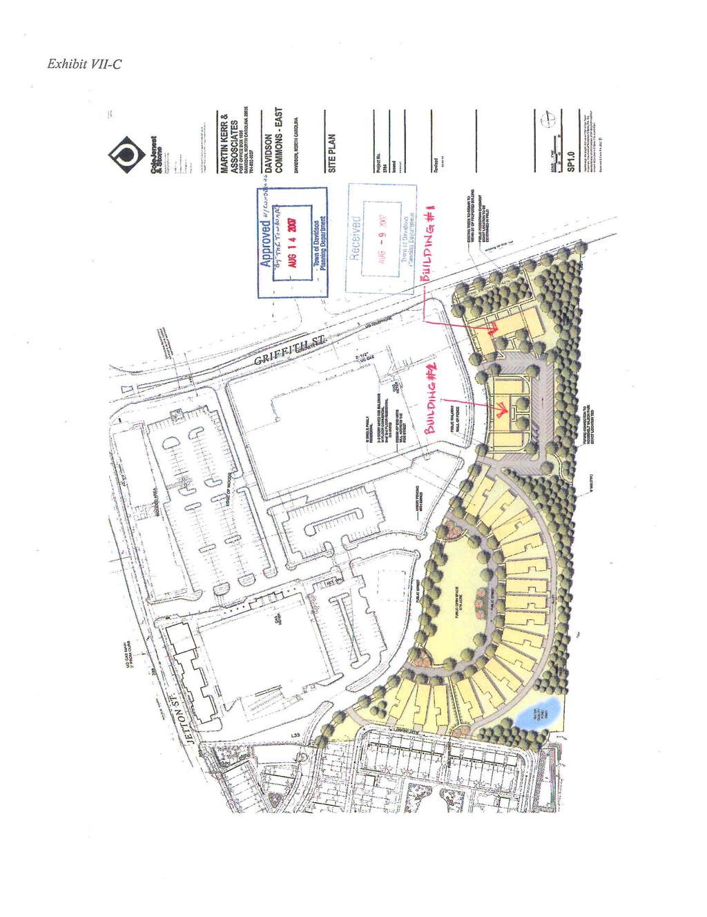
1 MEMO Date: July 31, 2017 To: Board of Commissioners & Planning Board From: Jason Burdette, Planning Director Re: Davidson Commons East Hotel, Preliminary Staff Analysis for Joint Work Session Conditional Master Plan Amendment 1. INTRODUCTION APPLICANT INFO Developer: Nish Patel, Beacon IMG, Inc. Owner: Davidson Commons East Condominium Associates Attorney: Susan K. Irvin Site Designer: Geoscience Group, Inc. Architect: The RBA Group Location: 131 Davidson Gateway Drive (Parcel IDs # , # ) Area: 2.1 acres REQUEST The applicant requests a Conditional Master Plan Amendment to develop a commercial hotel on 2.1 acres. The proposed hotel size would be approximately 74,500 square feet, four stories in height, and feature +/- 115 rooms. The proposal includes a pedestrian plaza along Griffith St. and a retail space on the site s northwest corner at the intersection of Griffith St. and Davidson Gateway Dr. SUMMARY OF PETITION The applicant requests specific conditions pertaining to: PROPOSED CONDITIONS 1. Building Type: The type of buildings permitted to be constructed on-site. 2. Height: The structure s overall height. 3. Impervious Coverage: The amount of hardscape permitted on the site. 4. Uses: The specific uses permitted on-site. 5. Setbacks: The proposed building/uses distance from surrounding properties or right-of-way. 6. Parking: The amount of on-site and off-site parking, and parking lot walking area, to be provided by the project. 1
2 7. Bicycle Parking: The amount of short- and long-term parking to be provided by the project. 8. Tree Canopy: The amount of tree canopy cover to be replaced on site. REMOVED CONDITIONS - The pedestrian trail shown on the Master Plan from the eastern portion of the Site to the Town of Davidson property should be removed. A complete list of the proposed conditions is included as Attachment A. 2. PLANNING STAFF REVIEW BACKGROUND The proposal seeks to replace an existing conditional master plan approved in 2006 and which has since been amended multiple times. Common law vested rights for these lots were established through a series of actions, including a public charrette and plan amendments, taken from Originally, the four lots along Davidson Gateway Drive (Lots 4A-D) were part of the Davidson Commons Master Plan and envisioned to become 42 townhomes. In 2007, the Davidson Commons East Conditional Master Plan proposed to replace these 42 townhomes with 16 single-family detached homes on Lots 4C- D and two commercial buildings consisting of 24 office/retail/residential condominiums on Lots 4A-B (Attachment B). The commercial buildings were approved to be two to three stories in height. In response to market conditions the owner requested a plan amendment in 2008 that allowed a greater proportion of commercial uses, though the overall building and site designs remained unchanged. Architectural designs for the two mixed-use buildings were approved by the Design Review Board in 2008, but the individual site plans for these lots were not submitted for review and therefore the projects did not move forward through the development process. In 2010 the Davidson Commons East Conditional Master Plan was once again amended, with the 16 single-family detached homes on Lots 4C-D evolving to become two mixed-use buildings of two- to three-stories and an athletic field (Attachment C). The commercial building on Lot 4C, Woodies Automotive, was approved in 2013 via another Conditional Master Plan amendment and constructed in The proposed hotel site comprises Lots 4A-B, the two northernmost lots along Davidson Gateway Dr., with Lot 4A fronting both Davidson Gateway Dr. and Griffith Street. Currently, Lots 4A-B function as a surface parking lot and Lot 4D is largely a graded, grassy plain. The Conditional Master Plan seeks to replace the existing, approved plan for two mixed-use commercial/residential buildings of two to three stories each to permit a hotel featuring four stories. PROCESS/TIMELINE The applicant met with town staff at various times during 2016 to discuss the development of the 2.1 acre tract of land as a commercial hotel. During those conversations, staff and the applicant discussed the process to move the project forward. The property s current designation as a Conditional Planning Area and the site/building s proposed features, some of which do not fully comply with the planning ordinance, led the applicant to request a Conditional Master Plan amendment (DPO 14.5). 2
3 In August 2016 the applicant officially filed a concept plan, which was deemed to be a complete submittal on 8/26/16. Based on the concept plan submittal date, this staff analysis considers compliance with the Davidson Planning Ordinance in effect on August 26, The concept plan was reviewed by Mecklenburg County staff and the Davidson Planning Department, who made comments prior to the October 3, 2016 Public Input Session (PIS). About 75 citizens attended the PIS, providing feedback on the proposed plan. Some of this feedback was incorporated in the latest design (see Public Comment discussion below). Subsequently, the developer performed a Transportation Impact Analysis (TIA) so that the proposal s effects on traffic were more clearly understood; this was required because the estimated building s size at the time of the sketch plan submittal exceeded 75,000 SF, the threshold over which commercial projects must perform a TIA. From November 2016 February 2017 the TIA was performed by a consultant, reviewed, and accepted by Planning Dept. staff (see the TIA discussion below). The TIA and PIS Report were posted to the project webpage in March In late February the project team re-engaged the Planning Dept. staff with revised designs based on the PIS and TIA. From February to May the applicant worked to provide further revisions and clarifications, officially submitting a Conditional Master Plan on 5/31/17. The application and requested revisions were again reviewed by Mecklenburg County staff and the Davidson Planning Dept., and were deemed complete on 7/7/17. Additional information regarding the project timeline and schedule can be found on the project webpage. CONTEXT As noted earlier, the proposed hotel lies on two parcels at the corner of Davidson Gateway Dr. and Griffith Street. The site slopes eastward toward an intermittent stream, across which is a Town-owned property and low-density residential homes. Woodies Automotive is immediately adjacent to the south, and across Davidson Gateway Drive to the west is the Community School of Davidson s elementarymiddle school campus (CSD). Across Griffith St. to the north is Spinnaker Cove, a low-density residential development. Moving beyond the immediately adjacent uses, the site lies on the eastern edge of a targeted growth node (described in greater detail below). This area, known as the 30, features a mix of uses including hotel, office, retail, restaurant, and higher-density residential buildings. The site is nearly equidistant between both I-77 and downtown, lying roughly one-half mile from each. PLANNING AND DEVELOPMENT STANDARDS Below is a summary of general planning and development standards relating to this proposal. Note: For the purpose of this analysis, the Lakeshore Planning Area is considered to be the underlying planning area for the proposed site. LAND USE The existing, approved plan permitted the development of two, three-story mixed-use buildings one fronting Davidson Gateway Dr. and one fronting Griffith Street. This plan allowed commercial, office, retail, and residential uses to be located in each building. These uses are consistent with the overall pattern of uses in the 30 area. The proposed plan updates and clarifies the specific uses allowed on Lots 4AB by utilizing the 2015 DPO terms. The specific uses requested are: Hotel/Inn; Commercial Services; Restaurant; and, Retail, Primary 3
4 & Secondary. Examples of each of these uses exist both near and in the broader vicinity of the subject site. The proposed hotel use, including a bistro and retail component, would be consistent with the existing and future land uses envisioned for the 30 area. BUILDING TYPE, HEIGHT, & SETBACKS Building types vary throughout the 30 area and range from detached, attached, and multifamily residential buildings to retail and office buildings that fit with the current DPO s Storefront and Workplace building types. The plan amendment proposes the construction of a Workplace building. This building type requires features such as principal entries fronting primary streets, a minimum level of 65% façade transparency on the ground floor, and architecturally-distinguished floor levels and entryways. This building type is permitted by-right in the Lakeshore Planning Area, with an allowable height of two to four stories. When surveying other buildings in the immediate and broader vicinity, the proposed height is consistent with that of existing buildings. For comparison, approximate height values for nearby buildings are: One Harbor Place (Sabi Restaurant) is three stories, or 51 to parapet; Two Harbor Place (Dunkin Donuts) is three stories, or 57 to parapet; The Linden is four stories, or 48 to parapet; Woodies Automotive is two stories, or 36 to parapet; and, Homewood Suites is five stories, or 59. Notably, these buildings are adjacent to other commercial or high-density residential areas. Where the buildings approach the higher-density residential blocks there is a transition, or step-down, in height that occurs across a right-of-way. This transition typically spans less than two stories in height differential between the commercial building and adjacent residential property. Lastly, the project proposes 0 setbacks. This is consistent with the permitted setbacks for Storefront and Workplace buildings in the Lakeshore Planning Area as well as existing buildings close by (Woodies, Davidson Day School, Harbor Place One & Two, Homewood Suites, and The Linden). In this location, where pedestrian mobility is important, buildings with active ground floor uses placed close to the sidewalk activate the streetscape as evidenced by many of the uses in the nearby Davidson Commons and Linden buildings along Jetton Street. On Davidson Gateway Dr. the building will be adjacent to the sidewalk; along Griffith St., the building will be setback approximately 20 or more behind a pedestrian plaza. STREETSCAPE With its location on a corner, the proposed hotel will front two streets: Griffith St. and Davidson Gateway Drive. The site s location in a highly-walkable area means that close attention should be paid to the pedestrian experience along each of these streets. At 10 wide, the sidewalk along Davidson Gateway Dr. continues and expands the established pathway from Woodies to Griffith St., and includes a low-rise wall to screen surface-level parking from pedestrians. Along Griffith St., the sidewalk width increases to approximately 13. Additionally, the plan proposes a decorative brick wall along this walkway, which must meet a three foot maximum height in the front setback permitted by DPO D. Behind this area lies a plaza intended to function as an inviting, semi-public space. It is designed to be ADA-accessible and to allow easy access from Griffith St. via low-rise steps and an at-grade ramp originating near the retail component. These features, in combination with additional landscaping, decorative paving, and fountains, aim to create a permeable, engaging public realm. Along both frontages street trees and landscaping must be provided in accordance with DPO
5 PARKING, ACCESS, & TRANSPORTATION The plan proposes to utilize a mix of parking formats including off-street surface parking (69), on-street parking (30), and a shared parking arrangement with the adjacent Woodies Automotive building (14), for a total of 113 spaces. For commercial properties, DPO Table 8-1 lists a minimum parking requirement of two spaces per 1,000 SF of commercial floor area. At 74,500 SF in total building area, this results in a required parking minimum of 149 spaces (which translates to 1.3 spaces per room). This table considers only gross commercial floor area and does not distinguish between different uses that may generate different trip patterns. Nearby jurisdictions utilize a one parking space per hotel room requirement while also factoring in parking for meeting spaces included within the building; in mixed-use districts the ratio is 0.5 spaces per room. Continuing, DPO D allows for adjacent non-residential uses to share up to 50% of the required off-street parking spaces available, which in this case would allow for use of existing spaces on the Woodies property (14 have been indicated by the developer). The current proposal represents a 36-space difference in the required (149) and proposed parking (113). However, as noted above, usage patterns vary depending on the nature of each commercial space. In this case, assigning one parking space to each hotel room may not accurately reflect actual parking demand. Based on their experience developing and operating the nearby Homewood Suites Hotel, the developer believes that parking area to be over-built after observing actual usage patterns the parking lot at this site is only 84% full on sold out nights, with peak demand occurring after 6:00 pm. The developer noted that many visitors do not arrive at that hotel in their own private car but instead utilize taxis, corporate transportation, or ride-sharing services that do not require their use of parking facilities. Their experience in this local context informed the current proposal. At 113 spaces, the proposed parking ratio is 0.98 spaces per room; if the Homewood Suites experience is an accurate indicator, then on sold out nights the hotel could anticipate needing 97 parking spaces. Regarding access, the proposal eliminates the first curb cut off of Davidson Gateway Dr. and instead utilizes the existing shared driveway with Woodies to provide site access. This provides two benefits: 1. It affords a better pedestrian experience along Davidson Gateway Dr. by eliminating a potential conflict point between vehicles and pedestrians; and, 2. It satisfies the requirements of Table 8-2, which discourages off-set driveways. Lastly, concerning other transportation requirements listed in the DPO, Section 6.10 deals with Transportation Impact Analysis (TIA). These exercises are used to evaluate whether the scale of development is appropriate for a particular site and what improvements may be necessary on- and offsite to provide safe and efficient access and traffic flow. These studies assist in understanding travel patterns in and around the site, which is especially helpful considering the project s proximity to schools uses which generate a very high amount of traffic, both motorized and non-motorized, during certain periods of time each weekday. Based on the estimated building s size at the time of the sketch plan submittal, the developer was required to perform a Transportation Impact Analysis (TIA) so that the proposal s effects within its land use context were more clearly understood. From November 2016 February 2017 the TIA was performed by a consultant, reviewed, and accepted by the Planning Dept. staff (see the project webpage for the full report). The analysis compared the proposed hotel with the previously-approved master plan, which allowed two mixed-use buildings to be constructed on the same site. At all locations, the impacts of the previously approved development were projected to be much greater than the proposed hotel use (Pg. iii). The report concluded that the proposed development will not have a significant impact on the surrounding roadways or multi-modal infrastructure in the project vicinity. It 5
6 did note that the intersection at Davidson Gateway Dr. and Griffith St. is expected to experience a slight up-tick in wait time during the morning (iv). However, the report stated that this should be anticipated for any level of development that occurs on the subject site and characterized the delay as minimal (iii). Notwithstanding these points, pedestrian safety throughout this area remains imperative given the site s proximity to nearby schools. The proposal presents the opportunity to secure improvements at select locations, a topic discussed in greater detail in the Staff Recommendation section below. OPEN SPACE/PARKS The Lakeshore Planning Area requires a minimum of 5% of the development to be dedicated open space. For this site, that equates to roughly 4,500 SF of open space. Per DPO 7.2.2, development within 0.25 miles of an existing public park may receive a reduction in the required open space area, not to exceed 25%. This site s proximity to Roosevelt Wilson Park enables a reduction of up to 1,125 SF, leaving 3,375 SF of required open space. At 7,311 feet and considering the illustrated design, the proposed plaza area along Griffith St. meets the criteria listed in DPO 7.4. WATER QUALITY The site is located in the Lake Norman Watershed Critical Area. This means that it is limited in the total amount of impervious coverage it can provide on-site (i.e. hardscape surfaces). Based on prior approvals, the total allowed amount for Lots 4A-D is 120,521 SF. Over the years, the various plans and plan amendments associated with this site have allocated the allowed impervious coverage in different ways. For example, Woodies Automotive is now constructed and that site s impervious coverage has been subtracted from 120,521, leaving Lots 4A, B, and D to split the remaining value. The chart included as part of the proposed project conditions specifies these values (see Attachment A). Lots 4AB are allocated 52,360 SF, collectively, and the proposed plan illustrates 52,336 SF of impervious coverage, which meets the requirement. ADDITIONAL CONSIDERATIONS Two additional topics relevant to this site s development have been identified and are introduced below. These are worth careful study by the Planning Board and Board of Commissioners. ADJACENT USES To the site s southeast lies low-density residential development. Unlike properties to the north, these properties are not separated from the project by a street. Moreover, these properties elevation sits below that of the project site. Although the Town s form-based code favors well-scaled transitions between uses rather than isolating buffers (especially in non-rural areas), in some cases wherein the rear properties adjoin different uses vegetated cover may be appropriate. To address this issue and compensate for the removal of tree canopy cover along Griffith St., the proposal includes replanting the site s eastern buffer with additional large, mature tree cover. Specifically, the east/southeastern area of the site adjacent to residential uses will include: Eight trees along the parking lot perimeter, as required per ordinance; six new trees below the parking lot that will assist in screening the retaining wall; and, five existing, mature trees that will be retained as part of the proposed plan. See Sheet L1.2 for planting details. 6
7 TREE CANOPY/GRIFFITH STREET Currently the site features stands of mature trees along Griffith Street. Along with trees on the north side of the street, these create a canopy that frames the street. The stands are less formalized than the trees one block west along Griffith that line the street for the length of the CSD campus. The 2007 Conditional Master Plan revision included a 0.21-acre public open space along Griffith St. with the intent of preserving the existing tree stands. However, the 2010 amendment removed this provision. Retaining the tree stands means that the building must be set back further from the roadway, which potentially results in the following tradeoffs: 1. A building setback that is inconsistent with the DPO s setback standards for the Lakeshore Planning Area as well as new construction that has occurred throughout the 30 area. However, pedestrian features such as plazas, walkways, and sidewalk cafes may be included as part of the front setback area. 2. A less viable commercial retail location at the corner of Davidson Gateway Dr. and Griffith Street. 3. A less formalized streetscape than occurs on adjacent properties and that is required throughout new development in the 30 area. 4. Limitations on the building and site design, including the amount of parking able to be provided on-site. These tradeoffs were carefully considered throughout the site design process, including with regards to feedback about amenities received at the 10/3/17 PIS; the tradeoffs noted above; and, town-adopted plans and goals (listed below in Plans & Policies). The revised plan reflects a building location consistent with town requirements and aims for targeted growth nodes, resulting in the replacement of the existing Griffith St. canopy with a plaza, formalized streetscape, and retail component. To address the loss of trees along Griffith St., the formalized streetscape contains mature tree plantings consistent with other development and, to the site s south/southeast, the plan proposes replantings as described above in the Adjacent Uses section. PRELIMINARY PROPOSED CONDITIONS The applicant requests specific conditions as part of this conditional rezoning. Please see Attachment A for a copy of the proposed conditions. Based upon public input and work session discussion, staff may propose additional conditions. 3. PUBLIC PLANS AND POLICIES Below is a list of town-adopted plans and a brief summary of each plan s applicability to the proposed Davidson Commons East Conditional Planning Area Hotel: The General Principles for Planning in Davidson (2015) include tenets to guide development in Davidson. Principles relevant to this proposed development are listed below. They can be summarized as: Davidson should focus on appropriately-scaled, high-quality infill development that balances residential and commercial uses, and in all cases strives to create vibrant pedestrian environments and public spaces. 1. We must preserve Davidson s character and sense of community. 3. We must encourage alternative means of active transportation. - Development and redevelopment in walkable, mixed-use, connected neighborhoods. - Planning commercial centers so walking, bicycling, and riding public transit to these destinations are viable options. 7
8 4. We must use our scarce land resources wisely. - Encouraging development that uses green design, energy conservation, and flexible spaces. - Ensuring that development builds up and not out. 6. We must manage growth so the town can provide public facilities and services apace with development. - Encouragement of economic growth without jeopardizing our sense of community. - Decisions based on the long-term goals of the comprehensive plan rather than a short term benefit. 7. We must enhance our quality of life through architecture and design. Livable environments include well-designed buildings, a dynamic public realm, and seamless connections between the two. This means that: - Private buildings and public infrastructure must work together to shape public space and to build community character. - The design of our public spaces, parks, and plazas will encourage social interaction, cultural experiences, and recreational opportunities. - Public art will animate our civic spaces. The Davidson Comprehensive Plan (2010) establishes a wide-ranging set of goals for the community to pursue, many of which are listed below. The Core Values and Goals emphasize Davidson s smalltown character; the creation of commercial business opportunities; safe, interesting pedestrian areas and public spaces; and, prioritizing development in designated growth areas. CORE VALUES Core Values, Character: Davidson s traditional character is that of a small town, so land planning will reflect its historic patterns of village-centered growth, with connection of neighborhoods, reservation of rural area, and provision of public spaces (Pg. 4). Core Values, Economy: Davidson s economic health is essential to its remaining a sustainable community, so town government will judiciously encourage and guide the location of new business opportunities (Pg. 4). GOALS & RECOMMENDATIONS Diverse Business/Job Opportunities: - Goal 1: Encourage independent and/or specialty retail in downtown and the Exit 30 area (Pg. 47). - Goal 2: Support and expand hotel and conferencing capabilities (48). Safe & Vibrant Public Spaces: - Vision: Eyes on the street and lively community gathering spaces provide safe places for children, pedestrians, and visitors. The town and private developers should continue to design, build, and manage public spaces (such as streets, greenways, parks, civic buildings, and commercial centers) that allow people of all ages and abilities to interact, create, and learn (49). - Goal 1: Continue to require human-scale, pedestrian-friendly architecture, brick sidewalks, attractive lamp posts and welcoming store fronts (50). - Goal 2: Ongoing Initiatives: New amenities such as public art, play equipment, and landscaping will energize existing transportation corridors, the transit station area, and 8
9 park properties (50); Provide venues to display Davidson College student and faculty sculpture exhibits off campus (50). - Goal 3: Consider traffic access management policies such as limited driveways along major roads; Improve crosswalk and lane marking visibility (50-51). Enable Faithful Stewardship: - Goal 3: Encourage rainwater capture and reuse in all new developments (61). Safe & Efficient Public Services: - Goal 2: Anticipate greater public safety concerns during the development review process (63). Maintain Quality Design & Sound Planning Principles: - Goal 1: Prioritize infill and mixed-use development within or near already developed areas (65); Provide additional mixed use centers close to existing neighborhoods (65). - Goal 2: Ensure compatibility and connectivity of new development with the surrounding context (66); Promote the use of green and local materials in new development (66); Coordinate new development proposals with approved small area plans (66); Continue to discourage franchise architecture (66). TARGETED GROWTH PLAN Preferred Growth Framework Criteria (71): - Growth should create a balance of commercial and residential development. - Development should be walkable and vibrant public spaces. - Growth should create a full range of employment and housing opportunities. - Growth should result in a more balanced local property tax base. - Growth should create high-quality pedestrian environments. Regional Commercial Center - Circles at 30 Area (72): - The Exit 30 area offers development potential for larger footprint development that may not be accommodated in the downtown. The visibility and proximity of the Exit 30 area to I-77 and waterfront will provide opportunities for employment growth. The 30 Small Area Plan (2013) aims to create a new, vibrant town center built according to the same principles as the historic downtown. Although not adopted, the plan contains several points that speak directly to the subject site. Recommendations relevant to this proposed development include: Continued two to four story mixed-use development along Griffith Street (pg. 9); Required retail frontage on Griffith Street (10); Smaller-scale development along Davidson Gateway Drive (i.e. two to three stories, 16); Consideration of angled parking on Davidson Gateway Drive (17). 4. PUBLIC INPUT SESSION On October 3, 2016 about 75 citizens attended a Public Input Session to learn more about the proposal and share feedback. Staff collected feedback from conversations as well as from the comment cards 9
10 submitted (49) and provided them to the applicant, who produced a PIS Report accepted by staff on 10/26/17. The report summarized the breadth of the comments as follows: Transportation: Concern about increased traffic and regarding the amount and type of parking provided, including whether on-street parking should be provided or whether parking could be shared with Woodies. Safety: Concern about the hotel s proximity to nearby schools as well as the town s public safety units ability to respond to a four- to six-story hotel fire. Environmental: Concern for impacts on the intermittent stream along the eastern boundary, and a desire to maintain existing trees along Griffith St. Aesthetics: Concern regarding the proposed six story building height and compatibility with surrounding uses. Amenities: Positive interest in the proposed amenities, including additional meeting spaces, lodging for visitors to the town (including businesses and the college), and potential restaurant and/or retail facilities on-site. In the report the applicant provided a response to each of these items, which is posted on the project webpage. Notably, the revised plan responds directly to several of the issues raised, including: The completion of a Transportation Impact Analysis outlining the traffic impacts; the provision of a variety of parking arrangements to meet the projected demand; a reduction in height and the completion of advanced architectural renderings for clearer illustration of the building s character; and, additional landscaping to replace mature tree canopy cover and provide a buffer to adjacent residential uses. Additional opportunities for public feedback with identified stakeholder groups are planned for August, and public hearings with the Board of Commissioners and Planning Board are scheduled for September. 5. STAFF RECOMMENDATION The purpose of the Joint Work Session Staff Analysis is to assess the updated, proposed plan against existing standards; provide the public, Planning Board, and Board of Commissioners with the known facts; and, offer direction on which topics have been addressed and/or should be further explored. PREVIOUSLY IDENTIFIED TOPICS After reviewing the application and documentation, staff offers the following commentary from October 2016 and present: 1. Transitions: October 2016: The General Statement of Intent states that the building will be respectful of the surrounding uses, including neighborhoods, and will feature innovative design solutions. Further information is needed regarding how the building will be respectful of surrounding uses, such as creating suitable transitions to surrounding properties. Nor have innovative design solutions been specified. July 2017: Addressing context, the revised plans include a reduced building height, formalized streetscape with trees and spacious sidewalks, and proposed mature tree replantings along the eastern boundary. Worth exploring further:» Context/Connections: For a project that anticipates many visitors arriving without an automobile, within walking distance of the 30 amenities and downtown, along with its location close to schools and a park, the improvement of existing/inadequate 10
11 2. Height: pedestrian facilities should be explored. A list of potential improvements is listed in the Additional Topics section below.» Innovative Design Solutions: Both the 2016 and 2017 General Statements of Intent assert that the building will incorporate innovative design solutions. The plaza represents a space that accommodates a variety of uses; but, beyond this feature, the application or plans do not specify what other innovative features are proposed. A better understanding of these proposed innovations is needed.» October 2016: The Davidson Planning Ordinance (DPO), documented plans, and existing uses/buildings all support multi-story, mixed-use development at this site. However, each of these indicates a range of two to four stories is most appropriate. The proposed height of 68 exceeds the permitted height of similar by-right development and the height of existing buildings. Certain sites in the 30 area may justify taller buildings locations near the interstate or at key junctures such as each traffic circle, for example. The merits of such an increase as proposed at the subject site must be carefully examined in light of surrounding uses/buildings, future benefits, and Comprehensive Plan goals.» July 2017: The revised plans illustrate a significant reduction in height from six to four stories, although the linear height of the building has not been specified. A clearer understanding of the proposed linear height is needed. 3. Tree Canopy:» October 2016: The DPO contains a variety of definitions for trees, including mature, canopy, and specimen trees. It s possible that the site, including Griffith St. frontage, contains several mature and perhaps a few canopy trees (i.e. those with a shade coverage greater than 1,200 SF), but it does not appear to contain any specimen trees. As noted earlier in the analysis, the existing tree stand creates attractive canopy coverage along Griffith Street, but this is not without tradeoffs. The potential benefits of a formalized streetscape (including new street trees and landscaping), building frontage consistent with the Town s principles, and ability to support active retail at the site s NW corner should be evaluated against the retention of the existing, informal tree stand along Griffith Street.» July 2017: The revised plans illustrate the building sited near the streets, which affords an array of benefits as described above. To address the existing trees lost, the proposal includes replantings as described earlier in the analysis Adjacent Uses section. 4. Active Uses/Ground Floor:» October 2016: Continuing from Item 3, the DPO, existing plans, and precedent all support the inclusion of at least one retail use at this site. The building s NW corner seems a natural location for this use, and the Comprehensive Plan s emphasis on engaging focal points/public space afford a unique opportunity at this site. Practically speaking, to be viable small-scale corner retail uses need: 1. Prominent placement on a primary street and/or corner; 2. A minimum of 10,000 vehicles per day (NCDOT current vehicle counts for Griffith Street range between 11,000-21,000 per day); and, 3. Convenient access (Principles of Urban Retail, Robert Gibbs, 3). Factors such as nearby residences or schools, both of which are adjacent to the site, augment the potential success of small-scale retail uses. The location of the building away from the primary street frontage along Griffith diminishes the viability of such uses. 11
12 Furthermore, although the developer has indicated that it s possible for the building to shift some of its planned in-house services such as a small coffee station towards the NW corner, the details of this arrangement and what type of public space it would yield are unclear. With the building set back significantly from Griffith Street, the opportunity for seamless pedestrian interaction with a potential retail use greatly diminishes. A continuous experience where a pedestrian may stop to look at sidewalk or interior merchandise displays, or browse a menu without leaving their walking course is a hallmark feature of good urban design and is integral to the success of buildings downtown and at Davidson Commons along Jetton Street. Significant building setbacks or unengaging uses such as passive or empty spaces (i.e. meeting rooms, gyms) aren t consistent with this approach. The building s placement on the site and uses along its primary and secondary streets must be judiciously studied.» July 2017: The revised plans include a retail component at the site s NW corner. Coupled with the inviting and accessible plaza design, the location positions this feature for success. Further thoughts on how to ensure the viability of this retail space as intended are included in the Additional Topics section below. 5. Public Spaces:» October 2016: This site presents a special opportunity to create a distinct, attractive public space at the corner of Davidson Gateway Drive and Griffith Street: An inviting focal point that marks the next punctuation in a vibrant streetscape extending from the second traffic circle on the way to Roosevelt Wilson Park. As detailed above, the building s placement on the site plays a critical role in achieving a pleasant, coherent pedestrian experience. A wellpositioned retail use would certainly strengthen the corner s appeal; but, regardless of this result, great effort should be put into constructing an attractive, publicly-accessible public space and a unified, interesting pedestrian experience along both of this site s primary and secondary streets.» July 2017: The revised plans include a unique plaza that distinguishes this site from typical hotel plans. Its balanced design with a variety of internal spaces, features, and accessibility options holds the potential to set the standard for engaging semi-public spaces in town. As suggested below, exploration of public art components would further enhance this appealing space. 6. Transportation:» October 2016: The site s proximity to the Community School of Davidson s elementarymiddle school campus merits exploring the potential transportation impacts of the proposed hotel. This is because of the high peak-hour trips generated by schools at certain times of day, as well as the developer s local experience with hotel guests transportation choices and parking requirements. In some contexts commercial uses such as hotels may generate less trips than other commercial or residential uses (such as medical offices or detached single-family residential dwellings). Therefore, a detailed Transportation Impact Analysis (TIA) should be conducted to understand the potential on- and off-site impacts of this development.» July 2017: Beginning in late 2016 through early 2017 the applicant worked with town staff to produce a TIA, described in fuller detail in the Parking, Access, & Transportation section of this analysis. Overall, the report did not anticipate significant impacts from the proposal. However, the revised plans reflect citizens concerns over parking through the provision of parking in a variety of formats to meet the projected demand. Moreover, as cited often in 12
13 this analysis and the TIA, Davidson places a premium on attractive, safe, and walkable streets. To that end, various ideas to further enhance the site and surrounding area have been included in the following section s potential improvements list. ADDITIONAL TOPICS FOR CONSIDERATION As noted throughout this report, the updated plans include targeted responses to many of the issues raised by the PIS Staff Analysis, citizens, and elected officials in the fall of Nonetheless, staff offers the following topics for consideration based on the latest plans: 1. Retail Space: A guarantee should be provided that the proposed retail component must meet the DPO definition of Retail Primary or Retail Secondary (DPO 16.3). 2. Public Art: The proposal should consider reserving space within the plaza or sidewalk areas along Griffith St. for public art, and the applicant should work with the town to provide a physical or financial contribution to public art (DPO B.6, General Planning Principle 7, Comp. Plan Safe & Vibrant Public Spaces). 3. Building Design: The proposal should reflect the highest design standards, including a commitment to green building as articulated in the Comprehensive Plan (Maintain Quality Design & Sound Planning Principles, Goal 2). The project should consider pursuit and achievement of LEED certification under the USGBC s LEED Rating System, or an equivalent standard. 4. Eastern Buffer: The proposed plan includes replanting of the buffer area along the project s eastern boundary. Consideration should be given to the replanting of the eastern buffer of Woodies Automotive with mature plantings to create continuous coverage (DPO 9.7.1). 5. Infrastructure: a. Pedestrian Crossings and Crosswalks: Four opportunities exist to improve connections to and from the project site: i. Mid-Block Crossing: Construction of or contribution towards a pre-designed crossing with a pedestrian refuge from Spinnaker Cove Dr. across Griffith St. (Walks & Rolls Plan Figure 4-2/Approximate to Grocery Lane). ii. Crosswalks: Construction of two textured/patterned crosswalks across Davidson Gateway Dr. at its intersection with Griffith St. and at the parking lot entrance (DPO H). iii. Stream Crossing: Construction of a 10 multi-use bridge along Griffith St. to cross the stream on the property s eastern boundary and connect to Roosevelt Wilson Park (DPO B, A; Walks & Rolls Plan Figure 4-2). b. Benches: As part of the plaza design, installation of at least two benches along Griffith St. (DPO B.5). c. Transit Amenities: As part of the mid-block crossing, on the north side of Griffith St., installation of a transit stop in accordance with CATS Standard 60.03C. Additionally, the establishment of a transit stop along Griffith St. at the project site (i.e. signage, bench per DPO B.5). d. Parking: Construction of on-street parking spaces and streetscape improvements on Griffith St. west of Davidson Gateway Dr. extending to Grocery Ln. 6. ATTACHMENTS/RESOURCES Attachment A: Applicant s Proposed General Notes & Conditions Attachment B: 2007 Davidson Commons East Conditional Master Plan 13
14 Attachment C: 2010 Davidson Commons East Conditional Master Plan Amendment ATTACHMENT A: GENERAL NOTES & CONDITIONS GENERAL NOTES 1. Zoning: The zoning of Tracts 4-A, 4-B, 4-C and 4-D of Davidson Commons East, consisting of 6.4 acres, more or less (the Site ), is CPA (Conditional Planning Area), as shown on the Davidson Commons East Conditional Master Plan, as amended November 10, 2010 and April 9, 2013 (the Plan ). The Site is to be developed in two phases. Phase II of the Plan was approved for a Change of Use on November 10, 2010 and an amendment to the conditions of Tract 4-C within Phase II was approved on April 9, Building & Site Design: The building configurations, placements, and sizes shown on the Master Plan are schematic in nature and may be altered and/or modified during design development and construction document phases in accordance with the approved plan. Parking layouts and open spaces may also be modified to accommodate final building configurations in accordance with the Planning Ordinance. 3. Ordinance Modifications: If, at some point, modifications are made to the Ordinance by the Board of Commissioners, the Applicant may voluntarily agree to apply such modifications to the Plan in a manner consistent with the Ordinance as it changes from time to time. Such modifications to the Ordinance shall in no way impact the Applicant's vested rights established per the Ordinance once the Plan is approved. 4. Amendments: The Applicant may request an amendment to the Plan and approved zoning without the written consent of any other owner of all or any portion of the property shown on the Plan so long as the recorded Declaration of Protective Covenants for the property contains a valid and enforceable provision with the stated purpose of granting power of attorney to the Declarant to execute an amendment to the Plan and approved zoning on behalf of such owners. Developer understands that the Town cannot waive the rights of property owners. 5. Plat Notes: In the event the event of an amendment to the plat of the Site, entitled Davidson Commons East Map 1, recorded in Map Book 49, Pages , Mecklenburg County Public Registry, as amended in Map Book 55, Pages 623, Mecklenburg County Public Registry (the Plat ), the notes included on the Plat shall be included on the subdivision plat of the Site; provided, however, Note 3 of the plat shall be revised to reflect the conditions provided below. CONDITIONS 1. Building Type: The hotel building shall be a Workplace building type in accordance with DPO Height: The Tract 4-A and 4-B Height Restriction is hereby amended to provide that the height allowed for the building located on Tracts 4-A and 4-B, as shown on the amended Master Plan, is a Minimum of Two (2) Stories and a Maximum of Four (4) Stories. 14
15 3. Impervious Coverage: Impervious Calculations Approved % of Total Existing Tract 4-A 26, % 12, Tract 4-B 26, % 12, Tract 4-C 34, % 34,161 Tract 4-D 34, % Unimproved Total 120, % 59,580 The 52,360 square feet of impervious cover allocated to Tracts 4-A and 4-B may be distributed among such Tracts in accordance with the approved amended Master Plan and may also be redistributed between Tracts if requested by the Applicant and approved by the Planning Director was modified prior to completion of such improvements. After completion, modifications of such improvements shall be permitted with Planning Director approval if such modifications do not exceed the total permitted impervious area for the combined Tracts and do not constitute a major amendment. 4. Uses: Permitted uses on Tracts 4-A and 4-B shall include Hotel, Commercial Services, Restaurant and Retail, Primary and Secondary. 5. Setbacks: The hotel building shall front on Griffith Street with minimum front and side setbacks of Open Space: [At this time the amount is not known. Once determined, this condition will be revised to state that XX acres or feet of open space is provided in accordance with DPO 7, as shown on the plan. The open space type - plaza, paseo, etc. should be specified per DPO 7.4.] 7. Parking: The parking requirement for lots 4-A and 4-B is 2 spaces per 1,000 square feet of building area, or 149 spaces; however, typical parking for a Hotel is 1 space per hotel room, or 115 spaces for this hotel. Parking provided on the plan totals 139 spaces, which is 120% of the typical requirement for a hotel. By comparison, at Homewood Suites in Davidson, the number of parking spaces typically used on a sold out night is approximately 84% of the number of hotel rooms. The majority of the Homewood Suites guests will need the parking spaces after 6:00 PM. Parking provided includes the shared parking in accordance with the Reciprocal Easement Agreement recorded in Book 30349, Page 645, Mecklenburg County Public Registry. This easement parking allows use of the additional spaces, which would only be required on sold out nights. 8. Bicycle Parking: Bicycle Parking provided is 6 long term spaces and 12 short-term spaces because hotel occupants typically are not using bicycles. This bicycle parking is provided for shoppers and workers. By comparison, at the Homewood Suites hotel, only one employee currently rides his bike to work. Therefore, even with shoppers and workers, the bicycle parking provided should be more than sufficient. 15
16 9. Tree Canopy: In order to fulfill the tree canopy requirements of 9.3.1A, Minimum Tree Coverage Requirements, 1.5 times the deficient trees, or 6 trees, will be planted in the southeast area of the property to help screen residential properties. 10. Walkway: DPO Pedestrian Access, provides, that in large parking lots (36 spaces or greater), a sidewalk perpendicular to the main building shall be put in place. This cannot be accomplished due to the proximity to the eastern buffer and the impervious requirements. REMOVED CONDITIONS - The pedestrian trail shown on the Master Plan from the eastern portion of the Site to the Town of Davidson property is removed. 16
17

18 ATTACHMENT C: 2010 Davidson Commons East Conditional Master Plan Amendment
MEMO 1. INTRODUCTION PURPOSE & PROCESS REQUEST
 MEMO Date: August 22, 2017 To: Board of Commissioners From: Jason Burdette, Planning Director Re: Davidson Commons East Hotel Stakeholder Feedback 1. INTRODUCTION PURPOSE & PROCESS This memorandum summarizes
Town Center (part of the Comprehensive Plan)
") Town Center (part of the Comprehensive Plan) Mercer Island Town Center Looking North (2014) In 1994, a year-long process culminated in a set of design guidelines and code requirements for the Town Center
Town Center (part of the Comprehensive Plan) Mercer Island Town Center Looking North (2014) In 1994, a year-long process culminated in a set of design guidelines and code requirements for the Town Center
4.1.3 LAND USE CATEGORIES
 4.1.3 LAND USE CATEGORIES a. City Center District The City Center District incorporates the existing character and mix of uses in downtown Belmont to encourage redevelopment and new development in keeping
Policies and Code Intent Sections Related to Town Center
 Policies and Code Intent Sections Related to Town Center The Town Center Vision is scattered throughout the Comprehensive Plan, development code and the 1994 Town Center Plan. What follows are sections
Lehigh Acres Land Development Regulations Community Planning Project
 Lehigh Acres Land Development Regulations Planning Effort Summary In July, 2010 Commissioner Frank Mann invited the Lehigh Acres community to start discussing how to achieve their recently adopted community
City of Farmington. Downtown Plan. Amendment to the 1998 Master Plan Adopted October 11, 2004
 City of Farmington Amendment to the 1998 Master Plan Adopted October 11, 2004 Introduction Planning Background 1 Scope and Components of the Plan Amendment 2 Concept Introduction 3 Plan Concepts 3 Conceptual
Mark-up of the effect of the proposed Bronte Village Growth Area OPA No.18 on the text of section 24, Bronte Village, of the Livable Oakville Plan
 Mark-up of the effect of the proposed Bronte Village Growth Area OPA No.18 on the text of section 24, Bronte Village, of the Livable Oakville Plan Notes: This document is provided for information purposes
EXISTING COMPREHENSIVE PLAN
 EXISTING COMPREHENSIVE PLAN Town Center Land Use Element: V. LAND USE POLICIES Town Center Mercer Island's business district vision as described in "Your Mercer Island Citizen-Designed Downtown" was an
ARLINGTON COUNTY, VIRGINIA
 ARLINGTON COUNTY, VIRGINIA County Board Agenda Item Meeting October 15, 2005 DATE: September 28, 2005 SUBJECT: Request to Advertise the adoption of the 2005 Clarendon Sector Plan C. M. RECOMMENDATION:
Uptown Rideau Street Secondary Plan [Amendment #166, January 12, 2016]
![Uptown Rideau Street Secondary Plan [Amendment #166, January 12, 2016]](/thumbs/76/73760497.jpg "Uptown Rideau Street Secondary Plan [Amendment #166, January 12, 2016]") [Amendment #166, January 12, 2016] The policies of this Secondary Plan are in effect, save and except for the property at 560 Rideau Street, for which there remains a site specific appeal to this Secondary
[Amendment #166, January 12, 2016] The policies of this Secondary Plan are in effect, save and except for the property at 560 Rideau Street, for which there remains a site specific appeal to this Secondary
13 THORNHILL YONGE STREET STUDY IMPLEMENTATION CITY OF VAUGHAN OPA 669 AND TOWN OF MARKHAM OPA 154
 13 THORNHILL YONGE STREET STUDY IMPLEMENTATION CITY OF VAUGHAN OPA 669 AND TOWN OF MARKHAM OPA 154 The Planning and Economic Development Committee recommends the adoption of the recommendations contained
A. Background Summary of Existing Challenges and Potential Possibilities. 1. Summary of Existing Assets and Potential Opportunities
 A. Background 1 A Main Street Master Plan Study was performed and completed in October of 2007. The study was initiated to review current land uses and development patterns along Main Street, from Parrish
Gold Line Bus Rapid Transit Transit Oriented Development (BRTOD) Helmo Station Area Plan
 Helmo Station Area Plan") Appendix F Gold Line Bus Rapid Transit Transit Oriented Development (BRTOD) Helmo Station Area Plan Introduction and Purpose of the Plan The Gold Line Bus Rapid Transit facility is an eleven-mile dedicated
Appendix F Gold Line Bus Rapid Transit Transit Oriented Development (BRTOD) Helmo Station Area Plan Introduction and Purpose of the Plan The Gold Line Bus Rapid Transit facility is an eleven-mile dedicated
ARTICLE 6: Special and Planned Development Districts
 ARTICLE 6: Special and Planned Development Districts 6-10 Traditional Neighborhood Development (TND) District 6-10.10 Purpose and Intent The Traditional Neighborhood Development (TND) District provides
MIXED-USE VILLAGE OVERLAY FLOATING DISTRICT
 MIXED-USE VILLAGE OVERLAY FLOATING DISTRICT Zoning regulations developed by committee to the Planning Board for the Town of DeWitt, NY Issue date: 13 July 2017 revised 3/12/2018, revised 4/26/2018, 5/9/2018
Westwind Developments Ltd. PIONEER LANDS AREA STRUCTURE PLAN - PROPOSED AMENDMENT
 FEBRUARY 2013 TABLE OF CONTENTS 1.0 BACKGROUND... 1 1.1 Amendment... 1 2.0 LOCATION & CONTEXT... 2 2.1 Land Ownership... 2 3.0 POLICY CONTEXT... 3 3.1 Municipal Development Plan... 3 3.2 Capital Region
Secrest Short Cut and Monroe Expressway Small Area Plan AUGUST 29, 2018
 Secrest Short Cut and Monroe Expressway Small Area Plan AUGUST 29, 2018 Background and Process Monroe Expressway will be open by the end of 2018 Union County and Indian Trail identified a need to revisit
Official Plan Review: Draft Built Form Policies
 PG.30.1 REPORT FOR ACTION Official Plan Review: Draft Built Form Policies Date: May 15, 2018 To: Planning and Growth Management Committee From: Chief Planner and Executive Director, City Planning Division
PINE CURVE REZONING. BACKGROUND Purchased as two parcels in 2001 and 2002
 BACKGROUND Purchased as two parcels in 2001 and 2002 WHAT THE PROJECT IS AND IS NOT A Rezoning establishes the land use standards for Annexed and Zoned Greater Downtown District Historic Center September
REQUEST Current Zoning: O-15(CD) (office) Proposed Zoning: TOD-M(CD) (transit oriented development mixed-use, conditional)
 (office) Proposed Zoning: TOD-M(CD) (transit oriented development mixed-use, conditional)") Rezoning Petition 2016-117 Zoning Committee Recommendation January 4, 2017 REQUEST Current Zoning: O-15(CD) (office) Proposed Zoning: TOD-M(CD) (transit oriented development mixed-use, conditional) LOCATION
Rezoning Petition 2016-117 Zoning Committee Recommendation January 4, 2017 REQUEST Current Zoning: O-15(CD) (office) Proposed Zoning: TOD-M(CD) (transit oriented development mixed-use, conditional) LOCATION
VILLAGE OF CLEMMONS PLANNING BOARD DRAFT STAFF REPORT
 VILLAGE OF CLEMMONS PLANNING BOARD DRAFT STAFF REPORT PETITION INFORMATION Docket # C-226 Staff Megan Ledbetter Petitioner(s) JBJH Properties, LLC Owner(s) JBJH Properties, LLC Subject Property 5892-49-1766
Staff Report to the North Ogden City Planning Commission
 Staff Report to the North Ogden City Planning Commission SYNOPSIS / APPLICATION INFORMATION Application Request: Concept review on a legislative application to rezone land located at approximately 1750
URBAN DESIGN BRIEF URBAN DESIGN BRIEF 721 FRANKLIN BLVD, CAMBRIDGE August 2018
 URBAN DESIGN BRIEF URBAN DESIGN BRIEF 721 FRANKLIN BLVD, CAMBRIDGE August 2018 DESIGN BRIEF CONTENTS PART A 1.0 INTRODUCTION 2.0 DESCRIPTION & ANALYSIS OF SITE CONTEXT 3.0 DESIGN CONSTRAINTS AND OPPORTUNITIES
Developer s Program. The Station at East 54
 Developer s Program The Station at East 54 Existing Conditions The Station at East 54 is proposed for a 1.12 acre site at the northeast corner of Hamilton Road and Prestwick Road, tucked between the East
MIDTOWN MIXED-USE VILLAGE. TECHNICAL DATA SHEET COMPONENT C-1 FOR PUBLIC HEARING - PETITION NUMBER Project No RZ1.1. Issued.
 N MIDTOWN MIXED-USE VILLAGE TECHNICAL DATA SHEET COMPONENT C- FOR PUBLIC HEARING - PETITION NUMBER 04-00 Project No. 496 Issued Revised SCALE: " = 0' N 0 0 0 40 RZ. c GENERAL PROVISIONS: a. SITE LOCATION.
SUBJECT: Waterfront Hotel Planning Study Update TO: Planning and Development Committee FROM: Department of City Building. Recommendation: Purpose:
 Page 1 of Report PB-23-18 SUBJECT: Waterfront Hotel Planning Study Update TO: Planning and Development Committee FROM: Department of City Building Report Number: PB-23-18 Wards Affected: 2 File Numbers:
DRAFT PLAN PRESENTATION
 DRAFT PLAN PRESENTATION 1.23.2018 AGENDA Process Project Schedule Results from Visioning Workshop Draft Plan Highlights Concept Plans Feedback Next Steps PROJECT SCHEDULE KICK-OFF WORKSHOP August 29 th
CITY OF PUYALLUP. Background. Development Services
 CITY OF PUYALLUP Development Services 333 South Meridian Puyallup WA 98371 To: City Council From: Katie Baker, AICP, Planning Division Re: South Hill Neighborhood Plan Adoption Date: (Meeting date: February
Tonight s Agenda. Summary Presentation Open House. Group Discussion Next Steps: online community wide survey
 Community Open House February 22, 2018 Tonight s Agenda Summary Presentation Open House Station 1: Project Overview and Community Input Station 2: Draft Vision and Guiding Principles Station 3: Western,
D1 September 11, 2013 Public Hearing APPLICANT:
 D1 September 11, 2013 Public Hearing APPLICANT: BEACH MUNICIPAL FEDERAL CREDIT UNION PROPERTY OWNER: SISTERS II, LLC STAFF PLANNER: Karen Prochilo REQUEST: Conditional Change of Zoning (AG-2 Agriculture
CITY OF MERCER ISLAND DESIGN COMMISSION STAFF REPORT
 CITY OF MERCER ISLAND DESIGN COMMISSION STAFF REPORT Agenda Item: 2 March 9, 2011 Project: Description: Applicant: DSR11-004 The applicant is requesting approval to replace the existing exterior wood framed
MONTGOMERY COUNTY PLANNING DEPARTMENT THE MARYLAND-NATIONAL CAPITAL PARK AND PLANNING COMMISSION
 MONTGOMERY COUNTY PLANNING DEPARTMENT THE MARYLAND-NATIONAL CAPITAL PARK AND PLANNING COMMISSION MCPB Item No. Date: 3.10.2016 Site Plan 820160040 Nora School Parker Smith, Planning Technician, Area 1,
Gateway commercial MIXED USE MASTER SITE PLAN. CITILAND AIrDRIE GATEWAY VENTURE INC. airdrie GATEWAY COMMERCE CENTRE. airdrie, ALBERTA FEBRUARY 2012
 Gateway commercial MIXED USE MASTER SITE PLAN 1914 CENTRE STREET NORTH CALGARY, AB CANADA T2E 2S8 T. 403.264.7177 F. 403.264-7175 WWW.CITILAND.CA CITILAND AIrDRIE GATEWAY VENTURE INC. airdrie GATEWAY COMMERCE
FORMER CANADIAN FORCES BASE (CFB) ROCKCLIFFE SECONDARY PLAN. Official Plan Amendment XX to the Official Plan for the City of Ottawa
 ROCKCLIFFE SECONDARY PLAN. Official Plan Amendment XX to the Official Plan for the City of Ottawa") FORMER CANADIAN FORCES BASE (CFB) ROCKCLIFFE SECONDARY PLAN Official Plan Amendment XX to the Official Plan for the City of Ottawa 1 INDEX THE STATEMENT OF COMPONENTS PART A THE PREAMBLE PAGE Purpose...
FORMER CANADIAN FORCES BASE (CFB) ROCKCLIFFE SECONDARY PLAN Official Plan Amendment XX to the Official Plan for the City of Ottawa 1 INDEX THE STATEMENT OF COMPONENTS PART A THE PREAMBLE PAGE Purpose...
DRAFT Northeast Quadrant of Kipling Avenue and Highway 7 DRAFT AUGUST 29, Goals Land Use. The goals of this Plan are to:
 AUGUST 29, 2017 12.15 Northeast Quadrant of Kipling Avenue and Highway 7 12.15.1 Goals 12.15.2 Land Use The goals of this Plan are to: 12.15.2.1 General Provisions: a) Ensure the development of a compact
FLORIN ROAD CORRIDOR Site Plan and Design Review Guidelines Checklist
 FLORIN ROAD CORRIDOR Site Plan and Design Review Guidelines Checklist Applicant s Name: Project Address: Phone: Email: Applicant shall fill out the design guidelines checklist for all guidelines applicable
Section 9 NEIGHBORHOOD DESIGN
 Section 9 NEIGHBORHOOD DESIGN City of Lancaster Comprehensive Plan D u n k i n, S e f k o & A s s o c i a t e s, I n c. NEIGHBORHOOD DESIGN INTRODUCTION There are many ways in which a neighborhood can
SECTION UNIFIED DEVELOPMENT ORDINANCE SECTION Part 1 Ordinance. ARTICLE 1 Zoning Districts
 SECTION 1-100 UNIFIED DEVELOPMENT ORDINANCE SECTION 1-300 Part 1 Ordinance SECTION 1-100. Introduction. ARTICLE 1 Zoning Districts Crystal Lake strives to maintain a balance of various land uses for a
Rezoning Petition Final Staff Analysis June 18, 2018
 Rezoning Petition 2018-028 Final Staff Analysis June 18, 2018 REQUEST Current Zoning: MX-1 LLWPA (mixed use district, Lower Lake Wylie Protected Area), R-3 LLWPA (single family residential, Lower Lake
PINE CURVE REZONING. Property does not meet criteria for open space preservation and is not a candidate for a park
 PINE CURVE REZONING BACKGROUND Purchased as two parcels in 2001 and 2002 Annexed and Zoned Greater Downtown District Historic Center September 25, 2002 and October 7, 2002 WHAT THE PROJECT IS AND IS NOT
Application Number: SD Project Name: Walton Farms Preliminary Subdivision (acting as Master Plan)
") STAFF REPORT Town of Clayton Planning Department 111 E. Second Street, Clayton, NC 27520 P.O. Box 879, Clayton, NC 27528 Phone: 919-553-5002 Fax: 919-553-1720 Planning Board May 22, 2017 Application Number:
STAFF REPORT Town of Clayton Planning Department 111 E. Second Street, Clayton, NC 27520 P.O. Box 879, Clayton, NC 27528 Phone: 919-553-5002 Fax: 919-553-1720 Planning Board May 22, 2017 Application Number:
ARLINGTON COUNTY, VIRGINIA
 ARLINGTON COUNTY, VIRGINIA County Board Agenda Item Meeting of April 23, 2019 DATE: April 12, 2019 SUBJECT: SP #413 SITE PLAN AMENDMENT to permit a fixed bar in a private outdoor café space with associated
Applicant Name Phone / Fax / Address City State Zip Code . Property Owner Phone / Fax / Address City State Zip Code
 Master Development Plan Application Community Development Department City of Redmond 411 SW 9 th Street Redmond, Oregon 97756 541-923-7721 541-548-0706 FAX Master Development Plan Fee $38,862.52 File Number
CITY OF KEIZER MASTER PLAN APPLICATION & INFORMATION SHEET
 CITY OF KEIZER MASTER PLAN APPLICATION & INFORMATION SHEET PRE-APPLICATION CONFERENCE Prior to the actual filing of a Master Plan application, it is strongly recommended that the applicant contact Planning
Presentation of the Staff Draft. July 17, 2014 SSRVP Team, Area 3
 Presentation of the Staff Draft July 17, 2014 SSRVP Team, Area 3 Presentation Overview Introduction Plan Framework Plan Recommendations Implementation Next Steps and Request for Public Hearing on September
DRAFT. 10% Common Open Space
 % OF CHARLOTTE IS CATEGORIZED AS A. LAND USES : Placeholder map displaying location of Place Type GOALS: Accommodate XX% of future growth. Provide a concentration of primarily commercial and civic activity
Bourne Downtown Site Planning
 Prepared for: The Town of Bourne, MA In Cooperation with: Bourne Financial Development Corporation Prepared by:, Inc. June 24, 2009 Table of Contents Introduction and Summary... 1 Site Existing Conditions...
3.1 community vision. 3.3 required plan elements
 Chapter 3 Community Form 3.1 community vision 3.2 Parks & landscaping concepts 3.3 required plan elements D R A F T 20 Community Form Chapter 3 3.0 Community form 3.1 community vision The Specific Plan
THAT the attached Terms of Reference for the Thornhill Centre Street Study be approved.
 COMMITTEE OF THE WHOLE AUGUST 18, 2003 THORNHILL CENTRE STREET STUDY PLANNING FILE: 15.92 Recommendation The Commissioner of Planning recommends: THAT the attached Terms of Reference for the Thornhill
Small Area Plan. South Gateway
 Small Area Plan Adopted May 12, 2008 South Gateway Purpose. The South Gateway Small Area Plan defines the City s expectations for the future of the southern entrance to the City at Interstate 85 and Highway
Additional information about land use types is given in Chapter 5. Design guidelines for Centers and Neighborhoods are given in Chapter 7.
 4. Place Types Introduction In Albemarle County s Development Areas, the Neighborhood is the fundamental unit of community planning. The County s Neighborhood Model, an adopted part of the Comprehensive
FUTURE LAND USE ELEMENT
 FUTURE LAND USE ELEMENT GOAL I: To create and sustain a great place to live, play, and prosper Objective 1: The City of Ocala shall incorporate the principles and strategies of the Ocala 2035 Vision into
PART 1: PROJECT SUMMARY. The application is Attachment A. The site plan is Attachment B.
 Belleterre Subdivision Sketch Plan Town Board 8.7.17 Belleterre Subdivision Sketch Plan PART 1: PROJECT SUMMARY Applicant: Bowman Development Project Size: +/- 20.85 acres Parcel Number: 01115104 and 01115121
Complete Neighbourhood Guidelines Review Tool
 Complete Neighbourhood Guidelines Review Tool Prepared By: City of Regina Planning Department October 2014 Page 1 of 14 Community Development Review Checklist for Secondary Plans and Concept Plans The
Living in Albemarle County s Urban Places
 Living in Albemarle County s Urban Places ALBEMARLE COUNTY, VIRGINIA A Closer Look at Albemarle s Approach to Managing Growth and Creating Quality Urban Environments www.albemarle.org Page 2 Living in
BROOKHILL NEIGHBORHOOD MODEL ZONING MAP AMENDMENT PREFACE TO APPLICATION
 BROOKHILL NEIGHBORHOOD MODEL ZONING MAP AMENDMENT PREFACE TO APPLICATION June 15, 2015 Revised: August 1, 2016 I. VISION Brookhill is a proposed community based upon the principles of Albemarle County
The Vision. Photo provided by The Minervini Group. 46 Vision, Objectives & Strategies
 Vision, Objectives & Strategies The is the public framework and guide for future development of the Grand Traverse Commons. The establishes public polices for infrastructure, the preservation of natural
Executive Summary. NY 7 / NY 2 Corridor
 Executive Summary NY 7 / NY 2 Corridor Transportation and Land Use Study December 2005 Prepared for: Town of Colonie Capital District Transportation Committee Prepared by: Introduction: Land use decisions
WELCOME and introduction
 1 WELCOME and introduction Mobility Hub Locations within Burlington STUDY OVERVIEW STUDY OBJECTIVES The City of Burlington is developing four Area Specific Plans, one for each of Burlington s Mobility
(DC1) Direct Development Control Provision DC1 Area 4
 Direct Development Control Provision DC1 Area 4") . General Purpose (DC) Direct Development Control Provision DC Area 4 The purpose of this Provision is to provide for an area of commercial office employment and residential development in support of the
. General Purpose (DC) Direct Development Control Provision DC Area 4 The purpose of this Provision is to provide for an area of commercial office employment and residential development in support of the
ELMVALE ACRES SHOPPING CENTRE MASTER PLAN
 ELMVALE ACRES SHOPPING CENTRE MASTER PLAN Contents 1.0 INTRODUCTION... 2 2.0 LOCATION... 2 3.0 EXISTING CONTEXT... 2 4.0 VISION & GUIDING PRINCIPLES... 2 5.0 LAND USE AND BUILT FORM... 4 5.1 St. Laurent
V. Vision and Guiding Principles
 V. Vision and Guiding Principles The Master Plan for the Powers Ferry Corridor seeks a foundation in the desires of the community. At times, various elements of the community offered opposing viewpoints,
TRANSIT ORIENTED DEVELOPMENT PINELLAS COUNTY MPO LIVABLE COMMUNITIES INITIATIVE PINELLAS COUNTY COMPREHENSIVE PLAN AMENDMENTS
 PINELLAS COUNTY MPO LIVABLE COMMUNITIES INITIATIVE MODEL LAND DEVELOPMENT CODE TRANSIT ORIENTED DEVELOPMENT PINELLAS COUNTY COMPREHENSIVE PLAN AMENDMENTS MPO Livable Communities Initiative Goal: Improve
5.1 Site Plan Guidelines
 5. Community Core Guidelines Development of the Community Core will take place by plan of subdivision and site plan approval. It will occur in a phased manner that will reflect the timing of residential
The University District envisions, in its neighborhood
 Envisioning the University District Link Light Rail in Seattle s neighborhoods CIY OF SEALE CONCEP-LEVEL SAION AREA PLANNING RECOMMENDAION RESOLUION # 30165 EXHIBI L Vision 08.2000 he University District
CHAPTER 3 VISION, GOALS, & PLANNING PRINCIPLES. City of Greensburg Comprehensive Plan. Introduction. Vision Statement. Growth Management Goals.
 CHAPTER 3 VISION, GOALS, & PLANNING PRINCIPLES Introduction The Greensburg Comprehensive Plan is intended as a working community document. A combination of long and short-term goals, this document is intended
Chapter Master Planned Communities (MPC) District
 District") Sections 14.53.010 Purpose and Intent 14.53.020 Applicability 14.53.030 Procedure 14.53.040 MPC Standards 14.53.050 Required Findings 14.53.010 Purpose and Intent Chapter 14.53 Master Planned Communities
Sections 14.53.010 Purpose and Intent 14.53.020 Applicability 14.53.030 Procedure 14.53.040 MPC Standards 14.53.050 Required Findings 14.53.010 Purpose and Intent Chapter 14.53 Master Planned Communities
and services The protection and conservation of environmentally significant and sensitive natural heritage features and functions.
 6. Land Use 6.0 Preamble A healthy and livable city is one in which people can enjoy a vibrant economy and a sustainable healthy environment in safe, caring and diverse neighbourhoods. In order to ensure
WEST LOOP DESIGN GUIDELINES CHECKLIST
 WEST LOOP DESIGN GUIDELINES CHECKLIST Section 1.0 General Strategies 1.1 DESIGN EXCELLENCE: ENCOURAGE HIGH QUALITY AND INNOVATIVE DESIGN OF NEW BUILDINGS WITHIN THE WEST LOOP WITHOUT BEING PRESCRIPTIVE
CHARLES PUTMAN CHARLES PUTMAN AND ASSOCIATES, INC
 MEMORANDUM CHARLES PUTMAN & ASSOCIATES, INC. LAND DEVELOPMENT CONSULTANTS PLANNING ZONING PERMITTING 4722 NW Boca Raton Boulevard, Suite C-106 Boca Raton, Florida 33431 Phone: 561/994-6411 FAX: 561/994-0447
URBAN DESIGN BRIEF 181 Burloak Drive, Oakville
 URBAN DESIGN BRIEF 181 Burloak Drive, Oakville February 2017 Our File: 1730B 230-7050 WESTON ROAD / WOODBRIDGE / ONTARIO / L4L 8G7 / T: 905 761 5588/ F: 905 761 5589/WWW.MHBCPLAN.COM TABLE OF CONTENTS
Chapter 2: Vision, Goals and Strategies
 Chapter 2: Vision, Goals and Lake Elmo Today & Tomorrow Comprehensive Plan 2040 2 VISION, GOALS & STRATEGIES - DRAFT 4-6-2018 INTRODUCTION Comprehensive Plan Purpose Perhapse the most important objective
MONTGOMERY COUNTY PLANNING DEPARTMENT THE MARYLAND-NATIONAL CAPITAL PARK AND PLANNING COMMISSION
 MONTGOMERY COUNTY PLANNING DEPARTMENT THE MARYLAND-NATIONAL CAPITAL PARK AND PLANNING COMMISSION MCPB Item No. Date: 1/26/12 Hanover Shady Grove, Sketch Plan 320120020 Joshua Sloan, Coordinator, Joshua.Sloan@MontgomeryPlanning.org,
Future Five. Design/ Development Guidelines. January 2008 Amended June 08 per City Council motion
 Future Five Design/ Development Guidelines January 2008 Amended June 08 per City Council motion 5-Points Design Guidelines Table of Contents I. Introduction 3 II. Area boundaries 4 III. Review Process
Urban Planning and Land Use
 Urban Planning and Land Use 701 North 7 th Street, Room 423 Phone: (913) 573-5750 Kansas City, Kansas 66101 Fax: (913) 573-5796 Email: planninginfo@wycokck.org www.wycokck.org/planning To: From: City Planning
Table of Contents. Elm Avenue Improvement Plan City of Waco, Texas. Introduction 1. Existing Context 1 Figure 1 2.
 Table of Contents Introduction 1 Existing Context 1 Figure 1 2 Plan Guidelines 3 Future Urban Form 4 The West-End 4 Main Street 6 The East-End 7 Figure 2 9 Public Improvement Recommendations 7 General
Figure 3-1: Public Realm Plan
 3 Public Realm Figure 3-1: Public Realm Plan 3.1 Public Realm Concept The public realm concept for the Little Mountain site integrates a clear and accessible movement network with public spaces for social
Welcome to the Oakridge Centre Open House
 Welcome to the Oakridge Centre Open House Why is the City hosting this event? This open house is to inform you of a rezoning application submitted to the City of Vancouver to amend the existing CD-1 (Comprehensive
PART 1: PROJECT SUMMARY. Proposed Land Use: 120 single-family lots. The application is Attachment A. The site plan is Attachment B.
 PART 1: PROJECT SUMMARY Applicant: JBH Development, LLC and Hopper Communities, INC Project Size: +/- 80.48 acres Parcel Number: 01513107, 01513108, 01513109, 01513113, 01513120, 01513121, 01513122, 01513124,
Rezoning Petition Pre-Hearing Staff Analysis May 21, 2018
 Rezoning Petition 2018-028 Pre-Hearing Staff Analysis May 21, 2018 REQUEST Current Zoning: MX-1 LLWPA (mixed use district, Lower Lake Wylie Protected Area), R-3 LLWPA (single family residential, Lower
S A C R A M E N T O C O U N T Y JACKSON HIGHWAY & GRANT LINE EAST VISIONING STUDY
 JACKSON HIGHWAY & GRANT LINE EAST S A C R A M E N T O C O U N T Y P L A N N I N G D E P A R T M E N T SUMMARY AND WORKBOOK November 19, 2008 History of the Visioning Study Sacramento County has two growth
5 TOWN OF MARKHAM OFFICIAL PLAN AMENDMENT NO. 144 MILLIKEN MAIN STREET SECONDARY PLAN
 5 TOWN OF MARKHAM OFFICIAL PLAN AMENDMENT NO. 144 MILLIKEN MAIN STREET SECONDARY PLAN The Planning and Economic Development Committee recommends the following: 1. The communication from Brendan O Callaghan,
SDOT DPD. SDOT Director s Rule DPD Director s Rule DCLU DR SED DR of 7 CITY OF SEATTLE
 SDOT SDOT Director s Rule 2-07 DPD Applicant: CITY OF SEATTLE Page 1 of 7 Supersedes: DCLU DR 11-93 SED DR 93-4 Seattle Department of Transportation (SDOT) Department of Planning and Development (DPD)
Sheridan Boulevard S TAT I O N A R E A P L A N S H E R I D A N B O U L E VA R D S TAT I O N A R E A P L A N
 Sheridan Boulevard S TAT I O N A R E A P L A N 1 City of Lakewood Adopted November, 2006 S H E R I D A N B O U L E VA R D S TAT I O N A R E A P L A N The Vision The City of Lakewood s overall vision is
Asbury Chapel Subdivision Sketch Plan
 Asbury Chapel Subdivision Sketch Plan PART 1: PROJECT SUMMARY Applicant: NVR Inc. Project Size: +/- 76.13 acres Parcel Numbers: 02101112,02116101,02116112, 02116113 Current Zoning: Transitional Residential
PUBLIC RIGHT-OF-WAY IN THIS CHAPTER PUBLIC REALM
 PUBLIC RIGHT-OF-WAY This section provides design guidelines for improvements in the public right-of-way. The public right-of-way refers to streets, sidewalks, non-vehicular thoroughfares, parks and greenways
Hockessin Community Redevelopment Plan
 Hockessin Community Redevelopment Plan 3.1 Introduction The Community Redevelopment Plan for the Village of Hockessin is the result of the people s vision for a distinct village center that serves as the
Planning Commission Staff Report June 5, 2008
 Owner/Applicant Taylor Village Sacramento Investments Partners, LP c/o Kim Whitney 1792 Tribute Road #270 Sacramento, CA 95815 Staff Recommendation Planning Commission Staff Report Project: File: Request:
Welcome. Walk Around. Talk to Us. Write Down Your Comments
 Welcome This is an information meeting introducing the applications for proposed redevelopment of the Yorkdale Shopping Centre site at 3401 Dufferin Street and 1 Yorkdale Road over the next 20+ years,
What We Heard Report: Westmount Architectural Heritage Area Rezoning Drop-in Workshop
 What We Heard Report: Westmount Architectural Heritage Area Rezoning Drop-in Workshop August 2018 What We Heard Report: Westmount Architectural Heritage Area Rezoning Drop-in Workshop Executive Summary
SCHEDULE 'A' TO BY-LAW as Amended by AMENDMENT NO. 90 TO THE WHITBY OFFICIAL PLAN
 SCHEDULE 'A' TO BY-LAW 6413-10 as Amended by 6553-11 AMENDMENT NO. 90 TO THE WHITBY OFFICIAL PLAN SECTION A: GROWTH PLAN CONFORMITY PURPOSE: LOCATION: BASIS: The purpose of this Amendment is to: conform
4.9 Mendocino Avenue Corridor Plan Design Guidelines
 4.9 Mendocino Avenue Corridor Plan Design Guidelines The Mendocino Avenue Corridor Plan addresses the area between College Avenue and Steele Lane. Mendocino Avenue is a busy arterial that runs parallel
Transportation. Strategies for Action
 Transportation A major priority for the Overlake Neighborhood is to develop a multimodal transportation system. To achieve this system, a balance has to be found among travel, circulation and access needs;
The transportation system in a community is an
 7 TRANSPORTATION The transportation system in a community is an important factor contributing to the quality of life of the residents. Without a sound transportation system to bring both goods and patrons
Planning and Growth Management Committee. Chief Planner and Executive Director, City Planning Division. Pg12013 (File No NNY 34 OZ)
") 865 York Mills Road Official Plan Amendment Application Preliminary Report STAFF REPORT ACTION REQUIRED Date: February 28, 2012 To: From: Wards: Reference Number: Planning and Growth Management Committee
865 York Mills Road Official Plan Amendment Application Preliminary Report STAFF REPORT ACTION REQUIRED Date: February 28, 2012 To: From: Wards: Reference Number: Planning and Growth Management Committee
Today Land & People. Northeast Nampa Gateway District. Employment. Land Use Characteristics. Demographics. Current Zoning
 Today Land & People Employment Major employers include Saint Alphonsus, the College of Western Idaho, the Auto Mall, Sorrento Lactalis and Walmart. 3,004 jobs in 2010 (COMPASS-CIM 2040 TAZ data) 4,345
1.0 Purpose of a Secondary Plan for the Masonville Transit Village
 Report to Planning and Environment Committee To: Chair and Members Planning & Environment Committee From: John M. Fleming Managing Director, Planning and City Planner Subject: Masonville Transit Village
MEMORANDUM. DATE: March 15, Chairman and Members Community Redevelopment Agency. Leif J. Ahnell, C.P.A., C.G.F.O. Executive Director
 MEMORANDUM DATE: March 15, 2019 TO: FROM: Chairman and Members Community Redevelopment Agency Leif J. Ahnell, C.P.A., C.G.F.O. Executive Director SUBJECT: Camino Square, IDA No. CRP-16-02, located at 171
Planning Board Briefing
 Planning Board Briefing Why Now? The Sector Plan Implementation Chapter States: Before Stage 1 begins, the following must occur: Approval of the Sectional Map Amendment. Approval of the Greater Lyttonsville
Silverdale Regional Center
 Silverdale Regional Center Vision for Silverdale Regional Center The Silverdale Regional Center Plan (Plan) will guide the evolution of the Silverdale Regional Center from a collection of strip malls and