Project Goal. RRRC Living Towns Planning Workshp. Town of Halifax Revitalization Project. Dynamic Planning & Management Duo: July 12, 2006
|
|
|
- Madeleine Gregory
- 5 years ago
- Views:
Transcription


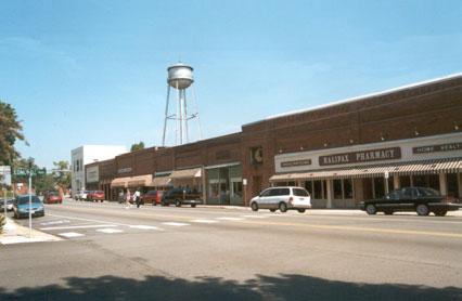
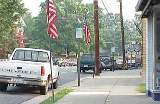
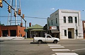
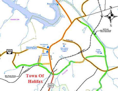
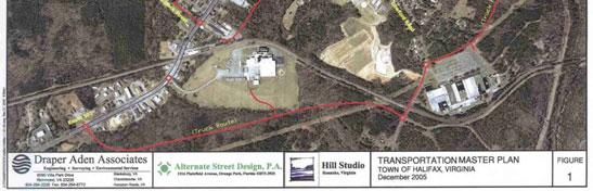
1 Project Goal Town of Halifax Revitalization Project RRRC Living Towns Planning Workshp July 12, 2006 Town of Halifax Halifax County *** Revitalization Project Goal*** To create Economic Opportunity and renew Quality of Life The Town and County of Halifax seek the shared community vision to promote the economic vitality of the Town of Halifax downtown commercial area, its approach corridors and gateways in an effort to provide new employment opportunities, capital investments and civic activities which improve the integrity of the historic county seat. Project Purpose Project Overview Dynamic Planning & Management Duo: Jerry Lovelace-Halifax County & Carl Espy-Town of Halifax Project Area-Regional & Local Setting Project Area-Streetscape Setting 1


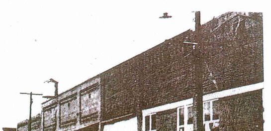
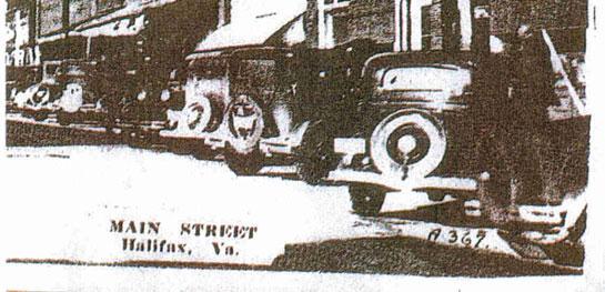
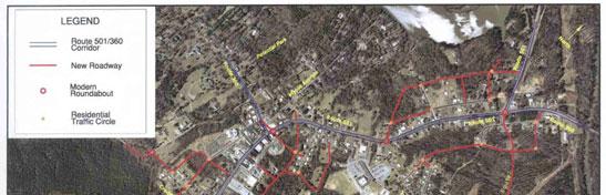
2 Project Area History Vision to Action-1974 Concept Downtown Preservation Sketchbook Recommendations Vision to Action-2003 Reality Community Input & Interaction Halifax County War Memorial Community Inventory Subcommittee Project Issues & Recommendations Signs, Materials and Themes - Carl Espy & David Martin Parking, Walking and Greenspace - Emmy Bass & Carl Espy Traffic -Leon Plaster Water, Sewer, Drainage, Sidewalks - Jack Dunavant, III Overhead Utilities - Bob Greene Land Use - Carol Throckmorton Overall Master Plan Roadway Improvements Streetscape Enhancements Overhead Utilities Parking Pedestrian Circulation Signs and Facades Gateways Phasing and Budget 2


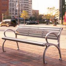
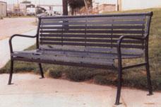
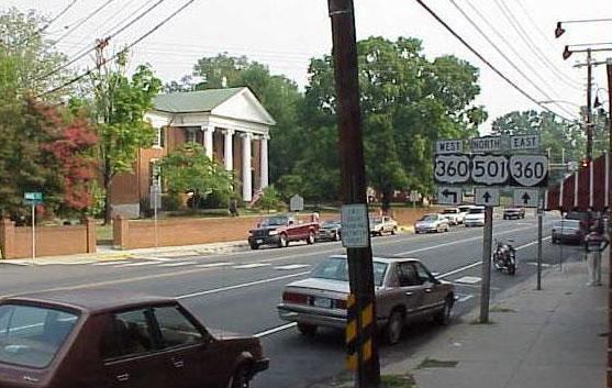
3 Downtown Halifax Master Plan Core Area Master Plan Project Issues Roadway Improvements Core Area Roadway Section Typical and Consistent Road Section Traffic Calming Defined Parking Intersection and Turn Lanes Controlling Access Core Area Roadway Section w/turn Lane Streetscape Enhancements Pressed Concrete Sidewalks in Core Area Colored Asphalt Crosswalks and Center Turn Lane Courthouse Wall Lowered with Historic Treatment Varied Street Furniture Appropriate Street Trees Add Pedestrian Scale Lighting 3


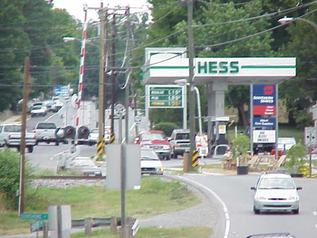
4 Streetscape Enhancements Streetscape Enhancements-Streetlights Project Issues Overhead Utilities Utility Relocation Approach Area Recommendations Approach Area Roadway Section Remove Overhead Utility Crossing Wires Retain Most Curbs and Walks Retain Parallel Parking Both Sides with Bumpouts Add Median Islands Defining Continuous Left Turn Lane Continuous Left Turn Lane Pressed Asphalt Add Pedestrian Scale Lighting 4

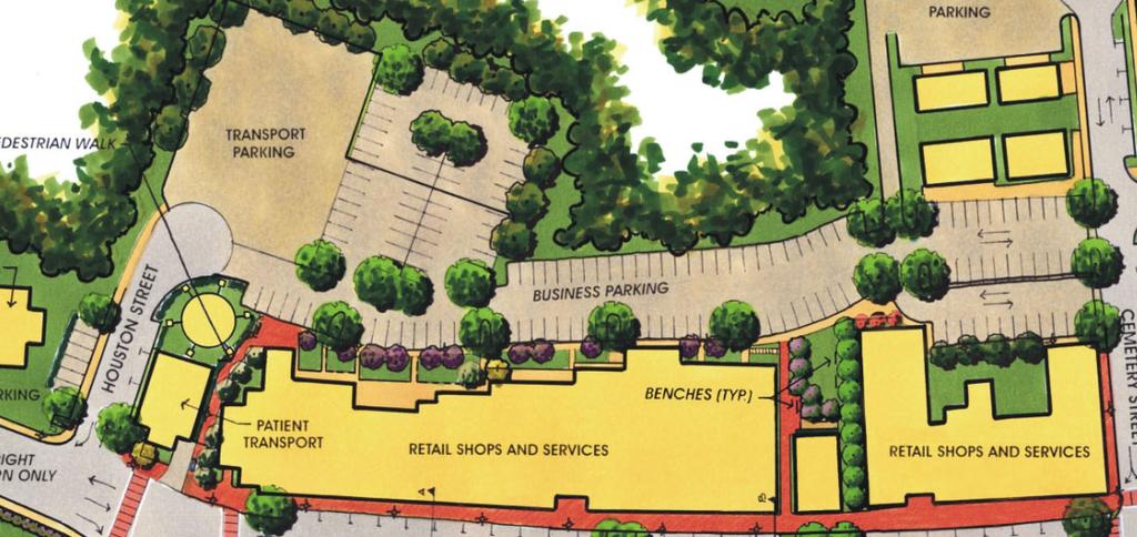
5 Project Issues - Parking Parking Assessment Existing 507 spaces Proposed 525 spaces Houston Street Parking Project Issues Pedestrian Circulation Pedestrian Circulation Recommendations Pedestrian-Parking Hybrid : Town Plaza Improve Sidewalks and Curbs Create Safe Pedestrian Crosswalks Connect Public Parking Areas to Main Street Create Public Plazas Tie to Overall Greenway Plan 5


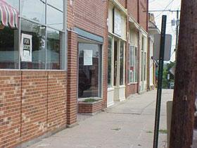
6 Pedestrian Circulation - Greenways Comprehensive Plan Update-Transportation Project Issues Image and Theme Project Issues Private Signs and Facades Preservation Sketchbook Facades Hill Studio Renderings Facades 6


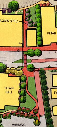
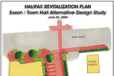
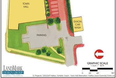
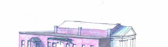
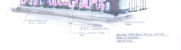
7 Hill Studio Design Guidelines Project Issues Public Signs Recommended Public Signs Northern Gateway Recommendations Sign at Town Limits Organize Existing Signs Add Gateway Sign at each Bridge Mountain Road Gateway Recommendations Southern Gateway Recommendations Improve Roadway Sign Location, Quantity and Organization Relocate Utilities around the War Memorial and Intersection of Mountain Road and Main Street Add Town Parking Lot Greenspace and Trees Improve Site Treatment of Buildings at Intersection Improve Welcome Sign at Town Limits Cleanup area at Toots Creek and Railroad Create Main Gateway Treatment at New Project location Gateway Sign Emphasizes Entrance to Approach Area Slow Traffic with Chokers before Median Planting and Sign Additional $70,000 in CDBG funding secured: Debris & Site Clearing Historic Register Eligibility Adaptive Uses & Cost Estimates 7


8 Southern Gateway Redevelopment-HSPC Halifax Roller Mill Redevelopment-HSPC Community Background Work Community Involvement for Future Activities Downtown Preservation Sketchbook, 1974 Better Models for Development in Virginia, 2001 Downtown Business & Consumer Surveys, 2002 General Greenway/Walking Concepts, 2002 Downtown Revitalization Plan, LandMark Design Group Downtown Historic District Survey, Department of Historic Resources Downtown & Gateway Façade Improvements, Hill Studio Multi-Use Trails & On-Road Bike System, Halifax County Trails Advisory Group Southern Gateway & Rollermill Project, Hill Studio Halifax Courthouse Historic District, Designation Eligibility Halifax County Historical Society Town of Halifax Comprehensive Plan Update, Hill Studio & Town of Halifax Planning Commission Halifax Last Mile Fiber Project, Halifax STEM Academy & Mid-Atlantic Broadband Cooperative Halifax Woman s Club Halifax County Improvement Council Halifax Village Business Association Southside Master Gardeners Association Banister River Garden Club Halifax County Historical Society Halifax County-South Boston Museum Friends of Halifax-South Boston Library Halifax County Tourism Department Halifax County-South Boston Chamber of Commerce Community Project Management Team Revitalization Impact on Town Tourism Beth Ann Gillis Carol Throckmorton Dr. Charles Parker Darnell Abbott Emmy Bass Jack Dunavant, III Rev. Roger Ford Mayor Leon Plaster Supervisor Doug Bowman William H. McCaleb Gerald V. Lovelace Gail P. Moody Tina P. Englebright Carl Espy, IV Interactive Mountain Road Walking Tour 8


9 Revitalization Progress in Boydton, Virginia Revitalization Progress in Halifax, Virginia Revitalization Progress- All in the Timing Revitalization Progress- Town of Halifax Downtown Revitalization Project NEWS RELEASE Streetscape construction will begin July 5, The work will entail the installation of storm drainage improvements, new sidewalks, the removal of the existing paved street surfaces, the installation of decorative streetlights and street resurfacing. Additional improvements to water and sewer facilities which started in the fall of 2005 will be completed during this time as well as the installation of fiber optic conduit as the first phase of the Town of Halifax Fiber Optic Project. The construction time frame will last until November 20, 2006, approximately. Revitalization Project Timeline FACADES Final Drawings Completed April/May 05 Bids Submitted July 05 Construction Begins May/June 06 STREETSCAPE VDOT Review (60-90 days) April 05 Bids Awarded October 05 Construction Begins July 06 9
Project Consulting Team:
 THE DOWNTOWN CHERRYVILLE LAND USE + STREETSCAPE MASTER PLAN WAS FUNDED THROUGH THE GENEROUS DONATIONS OF THE FOLLOWING: The Community Foundation of Gaston County ElectriCities of North Carolina The Cherryville
Johnson Street Bridge Public Realm Update
 Johnson Street Bridge Public Realm Update August 20, 2015 Background Johnson Street Bridge Replacement Project impacts a diverse range of stakeholders In addition to a new bridge, the project also includes
West Dennis Center: Bass River to Old Main Street. West Dennis Business District: Old Main Street to Dennis Commons
 West Dennis Center: Bass River to Old Main Street West Dennis Business District: Old Main Street to Dennis Commons Dennisport Center: Dennis Commons to Division Street Main Street Project Goals Project
Main Street Reconstruction From Ninth Line to Stouffer Street. Town of Whitchurch-Stouffville. Public Information Centre
 Main Street Reconstruction From Ninth Line to Stouffer Street Town of Whitchurch-Stouffville Public Information Centre November 23, 2016 4:30 to 6:00 pm & 7:00 to 8:00 pm 6240 Main Street, Stouffville
Copake Hamlet Plan: Visioning Workshop
 Copake Hamlet Plan: May 2-3 rd 2015 Hamlet Revitalization Task Force Jeffrey Nayer, Town Supervisor Jeanne Mettler, Town Board Chris Quinby Peggy Lewis Jennifer Redman Roberta Roll John Pollok Russ Davis
HOT SPRINGS COMPREHENSIVE PLAN OUTLINE
 HOT SPRINGS COMPREHENSIVE PLAN OUTLINE 7/28/2015 Draft outline - Hot Springs Comprehensive Plan Draft outline of topics to be discussed at public hearings and in planning sessions. Order and topics and
Small Area Plan. South Gateway
 Small Area Plan Adopted May 12, 2008 South Gateway Purpose. The South Gateway Small Area Plan defines the City s expectations for the future of the southern entrance to the City at Interstate 85 and Highway
The Long Road from Planning to Breaking Ground:
 The Long Road from Planning to Breaking Ground: A Collaboration Between Roanoke County and VDOT Megan G. Cronise, AICP VDOT Coordinating Transportation and Land Use Planning Forum May 10, 2018 Where is
The Project. In 2013, construction was completed between 100 Street and 102 Street.
 The Project Jasper Avenue New Vision (JANV) is a major catalyst project identified in the Capital City Downtown Plan (2010) between 92 Street and 109 Street, including the streets half a block north and
PIKE PINE RENAISSANCE: ACT ONE. October 19, 2017
 PIKE PINE RENAISSANCE: ACT ONE October 19, 2017 WATERFRONT SEATTLE PROGRAM PROJECT INTRODUCTION Pike and Pine streets, between First and Melrose avenues Pedestrian and streetscape improvements Budget:
The Auburn Plan Designing the Future of Auburn February 28, 2005
 The Auburn Plan Designing the Future of Auburn February 28, 2005 Block-by-Block Bicycle Tour Aerial survey Focus Group Meetings September 7 and 8 Design Workshops October 11, 14, and 21 Revitalization
Dyersville Downtown Plan. Open House October 24, 2017
 Dyersville Downtown Plan Open House October 24, 2017 What is a Comprehensive Plan? - Vision - Guidance for decisions - Basis for regulations What is a Downtown Plan? - Understand priorities - Identify
GREENING THE BOULEVARD Master Plan Concepts for Venice Boulevard between Lincoln and Sawtelle
 GREENING THE BOULEVARD Katherine Spitz Associates Inc. 4212½ Glencoe Avenue Marina Del Rey, CA 90292 310 574 4460 Fax 574 4462 January 2008 Table of Contents Overview Proposed Design Improvements Illustration
Downtown Papillion. Concepts for the Enhancement and Growth of Papillion s Traditional Town Center
 Downtown Papillion Concepts for the Enhancement and Growth of Papillion s Traditional Town Center Developed for the City of Papillion by RDG Planning & Design T raditional downtown districts occupy a particular
LITTLE ELM CAPTIAL IMPROVEMENT BOND STREET PRESENTATION
 LITTLE ELM 2009-2014 CAPTIAL IMPROVEMENT BOND STREET PRESENTATION Denton Frisco Little Elm Lewisville Legacy Southlake Grapevine Addison DENTON COUNTY & LEWISVILLE LAKE MATCHING FUNDS DENTON COUNTY BOND
10 Implementation. Implementation. Responsibility for Implementation. Blueprint for Bloomsburg. Town of Bloomsburg Comprehensive Plan 10-1
 Implementation 10 Implementation This chapter overviews how to use the comprehensive plan as a land use and programming tool for the Town of Bloomsburg and recommends annual review of the plan by the Town
SOUTH UNIVERSITY Street Design Alternatives in Progress
 1 Alternatives in Progress 2016.01.20 Meeting Agenda 2 1. Progress & Schedule 2. Utilizing the Street Design Manual 3. Site Characteristics and Input Received 4. Street Geometry What can we accomplish
Carlsbad Village Redevelopment Concept Summary of Features
 Carlsbad Village Redevelopment Concept Summary of Features Calthorpe Associates November 5, 2003 The Redevelopment Concept illustrates a vision for the future of Carlsbad Village. The overall vision of
Hockessin Community Redevelopment Plan
 Hockessin Community Redevelopment Plan 3.1 Introduction The Community Redevelopment Plan for the Village of Hockessin is the result of the people s vision for a distinct village center that serves as the
PLACEMAKING & MOBILITY WORKSHOP. January 27, 2016
 PLACEMAKING & MOBILITY WORKSHOP January 27, 2016 Boston needs more housing. But there is no one-size fitsall solution. Every neighborhood has its own character. In some places, density is not only appropriate
STAFF REPORT Agenda Item: J.4 To: Mayor and City Council Date:
 STAFF REPORT Agenda Item: J.4 To: Mayor and City Council Date: 2-14-2007 Thru: Charles McNeely, City Manager Subject: Staff Report: Approval of a project to be submitted for the NDOT 2007-2009 Landscape
CITY OF NORCROSS LILLIAN WEBB PARK REDEVELOPMENT AREAS
 7/2/2016 CITY OF NORCROSS LILLIAN WEBB PARK REDEVELOPMENT AREAS 2016 Potential Development Around Lillian Webb Park The Lillian Webb Park Development Project is located north of Buford Highway; east of
Mississippi Drive Corridor Revitalization. A DestinationTransportation Project...
 Mississippi Drive Corridor Revitalization A DestinationTransportation Project... Mississippi Drive Corridor Revitalization Welcome! Tonight s Agenda: Further define the Scope of the Project Discuss the
Potential Green Infrastructure Strategies May 6, 2015 Workshop
 Potential Green Infrastructure Strategies May 6, 2015 Workshop Background The City of Cortland is developing the Tioughnioga Urban Headwaters Green Infrastructure Action Plan with funding from the National
Main Street Streetscape Plan. Downtown Redevelopment Plan Phase One
 2012 Main Street Streetscape Plan Downtown Redevelopment Plan Phase One Message from Council Council Left to right: Dwight Ganske, Judy Bennett, Darren Badry, Mayor Ken Lemke, Robert Twerdoclib, Pat Hansard,
The Illinois Department of Transportation and Lake County Division of Transportation. Route 173, including the Millburn Bypass
 The Illinois Department of Transportation and Lake County Division of Transportation welcome you to this Public Hearing for U.S. Route 45 from Illinois Route 132 to Illinois Route 173, including the Millburn
THE CIVIC DISTRICT DEVELOPMENT OPPORTUNITIES
 1 THE CIVIC DISTRICT DEVELOPMENT OPPORTUNITIES The Civic District is the physical and emotional heart of the downtown. It is also a major gateway into the central core, establishing the image and identity
A larger version of this map is located on the last page of this PDF.
 MAP Committee Input McLoughlin Area Draft Vision Map A larger version of this map is located on the last page of this PDF. 1. The map above is intended to portray a vision for the McLoughlin area. It highlights
Open House RIVER DES PERES GREENWAY: LANSDOWNE SHREWSBURY METROLINK TO FRANCIS R. SLAY PARK
 Open House 10.12.16 RIVER DES PERES GREENWAY: LANSDOWNE SHREWSBURY METROLINK TO FRANCIS R. SLAY PARK MEETING AGENDA Great Rivers Greenway and Project Partners River des Peres Greenway Overview Project
PROPOSED REDEVELOPMENT OF THE GLEN ABBEY GOLF CLUB. STREETSCAPE DESIGN STUDY (excerpt from the Urban Design Brief) TOWN OF OAKVILLE.
 TOWN OF OAKVILLE.") PROPOSED REDEVELOPMENT OF THE GLEN ABBEY GOLF CLUB STREETSCAPE DESIGN STUDY (excerpt from the Urban Design Brief) TOWN OF OAKVILLE OCTOBER, 2016 for 2.4.2 STREETS Streets are the single largest component
PROPOSED REDEVELOPMENT OF THE GLEN ABBEY GOLF CLUB STREETSCAPE DESIGN STUDY (excerpt from the Urban Design Brief) TOWN OF OAKVILLE OCTOBER, 2016 for 2.4.2 STREETS Streets are the single largest component
TABLE OF CONTENTS. Transportation Chapter 1 - Introduction and Purpose of Planning to 1-3. Utilities
 Chapter 1 - Introduction and Purpose of Planning... 1-1 to 1-3 Pennsylvania Municipalities Planning Code (Act 247)...1-1 Previous County Planning Activities...1-1 Objectives of the Plan...1-2 Elements
Olde Towne Vision Plan
 Olde Towne Vision Plan Introduction In 2016, the City of Bellevue will complete its move of City offices from Olde Towne Bellevue to its new municipal complex on Wall Street. The City intends to sell its
The Lower SaLuda Greenway
 The Lower SaLuda Greenway InITIaTIve a FLourIShInG Greenway. a hub For economic GrowTh. a ConneCTIon BeTween CoMMunITIeS. In April 2017 the Michael J. Mungo Foundation and Lexington County commissioned
Downtown Redevelopment Project Update
 Downtown Redevelopment Project Update The redevelopment project will begin the week of September 4, 2017. It is anticipated that construction will be approximately 565 days, depending on weather. 7-6-18
Status Update (2006 vs. Now) Citizen s Advisory Committee February Plan for Prosperity
 Citizen s Advisory Committee February Plan for Prosperity") Status Update (2006 vs. Now) Citizen s Advisory Committee February 2018 Plan for Prosperity 2000 2017 2000 2017 Gardnerville Population 6,000 5,760 5746 5,500 5,000 5,067 5,550 5,165 5,394 5,412 5,250
Status Update (2006 vs. Now) Citizen s Advisory Committee February 2018 Plan for Prosperity 2000 2017 2000 2017 Gardnerville Population 6,000 5,760 5746 5,500 5,000 5,067 5,550 5,165 5,394 5,412 5,250
Shell Beach Road Streetscape Frequently asked Questions
 Shell Beach Road Streetscape Frequently asked Questions General What is the Shell Beach Road Streetscape Improvements Project? The overall goal of the Shell Beach Road Streetscape Improvement project is
Green Infrastructure The Indianapolis Greenways Connection
 Green Infrastructure The Indianapolis Greenways Connection Fewer things in the transportation industry today make better since than combining the needs for pedestrian and bike trails with the need to locate,
Welcome & Introductions
 Creating a Pedestrian Friendly Street American Public Works Association: 2009 Congress Session 4791 September 16, 2009 Welcome & Introductions Doug Roberts, P.E. Transportation Design Section Manager City
PLAN ELEMENTS WORKSHOP. April 5, 2016
 PLAN ELEMENTS WORKSHOP April 5, 2016 needs more housing. But there is no one-size fits-all solution. Every neighborhood has its own character. In some places, density is not only appropriate it is badly
Urban Design Webpage-Definitions
 Urban Design Webpage-Definitions What is Urban Design? Urban Design addresses the character and quality of the built environment in relation to the human scale. Urban designers are involved with building
appendix and street interface guidelines
 appendix five: building and street interface guidelines appendix 5 building and street interface guidelines BOULEVARDS Boulevards are generally characterized by higher levels of traffic movement at higher
SARANAC LAKE VISION CONCEPTS
 DRAFT SARANAC LAKE VISION CONCEPTS A GENUINE PLACE TO LIVE, WORK, SHOP AND EXPERIENCE CULTURE IN THE HEART OF THE ADIRONDACKS PHOTO COURTESY OF SARANAC LAKE SARANAC LAKE, NEW YORK DECEMBER 2007 SARANAC
2010 Tentative Enhancement Program Allocations (FY11)
") Bristol 10011 Buchanan County Buchanan County project cost $1,190,332 Bull Creek Trail - construction of a pedestrian/bicycle trail along abandoned request amount $240,323 railroad right of way. allocation
Bristol 10011 Buchanan County Buchanan County project cost $1,190,332 Bull Creek Trail - construction of a pedestrian/bicycle trail along abandoned request amount $240,323 railroad right of way. allocation
Abingdon Urban Path System
 Abingdon Urban Path System Transportation Enhancement Program Application (FY 2012-2013) Submitted by: Town of Abingdon,Virginia P. O. Box 789 133 West Main Street Abingdon, VA, 24212 November 1, 2011
July 12, Columbus City Council City Hall 90 West Broad Street Columbus, OH RE: I-70/71 Columbus Crossroads Project
 OHIO DEPARTMENT OF TRANSPORTATION DISTRICT 6 400 EAST WILLIAM STREET DELAWARE, OHIO 43015 800.372.7714 Columbus City Council City Hall 90 West Broad Street Columbus, OH 43215-9015 RE: I-70/71 Columbus
Public input has been an important part of the plan development process.
 Lakewood s Comprehensive Plan recognizes that transportation helps shape the community, and that the way the community provides for the safe and efficient movement of people affects the character of the
Fifth and Detroit Street Design May 2017 Capital Improvements Committee. DOWNTOWN Street Design
 1 Fifth and Detroit Street Design May 2017 Capital Improvements Committee Agenda 2 Review Street Configuration Prior Meeting Review Outreach Synopsis Functional Street Design Refinements Curb Edge, Turning
I-70/71 Innerbelt Project
 I-70/71 Innerbelt Project Project Progress Meeting and Design Enhancement Update November 9, 2009 Ohio Department of Transportation MS Consultants MSI Design Overview of Presentation 1. Recap Recent Project
Agenda Summary December 11, 2017
 Agenda Summary December 11, 2017 Agenda Item No. 5 VT 108 Roadway Master Plan for Mountain Road Village (Including the Luce Hill / Rt.100 Intersection) Summary: David Saladino, vhb Transportation Systems
Route 9 Gateway Project. October 9, 2014 Informational Meeting
 Route 9 Gateway Project NYS DOT P.I.N. 1759.67 Town of Lake George, New York October 9, 2014 Informational Meeting Open House 3:00-3:30 Presentation 3:30-4:15 Introductions Town Representatives Dennis
Welcome to the. Open House
 Welcome to the 5th Street to Kinsman Road Open House November 14 5:30 7:00 p.m. Please sign in Project Overview In December 2016, City Council adopted SW 5th Street as the preferred alignment to connect
Fall 2017 Construction Update
 Fall 2017 Construction Update Ward 4 Southeast Engineering Department Riverwalk Red Multi-Use Trail Bridge Rehabilitation The Riverwalk Red Multi Use Trail Bridge was awarded to Cramer and Associates,
Downtown Lead Revitalization Project Final Recommendations. Three Proposed Options for the Revitalization of Downtown Lead
 Downtown Lead Revitalization Project Final Recommendations Three Proposed Options for the Revitalization of Downtown Lead November 1, 2011 Three Proposed Options for the Revitalization of Downtown Lead
CITY OF BOYNTON BEACH SE 1 ST STREET COMPLETE STREETS IMPROVEMENTS
 CITY OF BOYNTON BEACH SE 1 ST STREET COMPLETE STREETS IMPROVEMENTS N Project Location -Town Square -Villages at Ocean SE 1st St, between E Woolbright Rd and SE 2nd Ave Project Location -Boynton One -Publix
Onondaga County Sustainable Streets Project. Onondaga County Planning Federation June 7, Onondaga County Sustainable Streets Project 1
 Onondaga County Sustainable Streets Project Onondaga County Planning Federation June 7, 2012 Onondaga County Sustainable Streets Project 1 Sustainable Streets 1. Introduction to the SMTC 2. Sustainable
Chain Bridge Road Sidewalk Improvements Citizen Council Work Session
 Chain Bridge Road Sidewalk Improvements Citizen Council Work Session May 10, 2016 Project Location 2 Project Objectives Provide a continuous pedestrian facility (sidewalk) connection from Downtown City
EXISTING COMPREHENSIVE PLAN
 EXISTING COMPREHENSIVE PLAN Town Center Land Use Element: V. LAND USE POLICIES Town Center Mercer Island's business district vision as described in "Your Mercer Island Citizen-Designed Downtown" was an
Table of Contents. Elm Avenue Improvement Plan City of Waco, Texas. Introduction 1. Existing Context 1 Figure 1 2.
 Table of Contents Introduction 1 Existing Context 1 Figure 1 2 Plan Guidelines 3 Future Urban Form 4 The West-End 4 Main Street 6 The East-End 7 Figure 2 9 Public Improvement Recommendations 7 General
Vision Plan. City of Hawthorne Historic Johnson Street. A Strategy for Economic Revitalization
 City of Hawthorne Historic Johnson Street Vision Plan A Strategy for Economic Revitalization Study and Vision Plan Developed by the City of Hawthorne www.cityofhawthorne.net CHW Professional Consultants
McLean Main Street Public Forum Exchange of Ideas
 McLean Main Street Public Forum Exchange of Ideas Sponsored & Hosted by McLean Planning Committee John W. Foust, Dranesville District Supervisor Fairfax County Office of Community Revitalization and Reinvestment
Blue Line LRT Extension
 v e Noble Pkwy Noble Pkwy Xerxes Ave N Shingle Creek Penn Ave N Penn Ave N Fremont Ave N Lyndale Ave N S Washington Ave University Ave NE Blue Line LRT Extension LIGHT RAIL PLATFORM AND STATION DESIGN
This is the East Carolina University Comprehensive Facilities Master Plan Final Draft Plan Review. This workbook reviews the campus draft master plan
 This is the East Carolina University Comprehensive Facilities Master Plan Final Draft Plan Review. This workbook reviews the campus draft master plan first presented on campus on June 29 and June 30, 2011.
Implementation Guide Comprehensive Plan City of Allen
 Implementation Guide 2030 Comprehensive Plan City of Allen DRAFT 2015 Implementation Guide Allen 2030 Comprehensive Plan INTRODUCTION The Comprehensive Plan serves as a guide for the growth and development
ROAD PAVING VARIOUS LOCATIONS LANE KM
 ROAD PAVING VARIOUS LOCATIONS 9.317 LANE KM $1,465,200 General: $1,465,200 BASED ON CONDITION ASSESSMENTS OF THE ENTIRE ROAD NETWORK; USING ASSET MANAGEMENT PRINCIPLES, ROADS THAT ARE SUITABLE FOR REPAVING
WELCOME and introduction
 1 WELCOME and introduction Mobility Hub Locations within Burlington STUDY OVERVIEW STUDY OBJECTIVES The City of Burlington is developing four Area Specific Plans, one for each of Burlington s Mobility
Project Profile BAR HARBOR
 1 BAR HARBOR The Bar Harbor Master Plan merges community vision with design guidelines to preserve the unique character of Bar Harbor Village. PROJECT SUMMARY Overview: The economic vitality of Bar Harbor
PORT CLINTON DOWNTOWN REVITALIZATION PLAN
 The City has been awarded a $2.34 million Ohio Department of Transportation (ODOT), Small Cities Grant for the complete reconstruction of Madison Street AWARD WINNING PROJECT Best of Lake Erie Award Lake
Hamilton Road Corridor Streetscape Master Plan. Open House October 4 th, 2017
 Hamilton Road Corridor Streetscape Master Plan Open House October 4 th, 2017 Agenda 1. Introductions Agenda Overview 2. Project Background 3. Existing Conditions 4. Strengths, Weaknesses, Opportunities
City of Farmington. Downtown Plan. Amendment to the 1998 Master Plan Adopted October 11, 2004
 City of Farmington Amendment to the 1998 Master Plan Adopted October 11, 2004 Introduction Planning Background 1 Scope and Components of the Plan Amendment 2 Concept Introduction 3 Plan Concepts 3 Conceptual
Chapter 14 Streetscape Improvements
 This chapter presents streetscape design concepts for key streets and gateways in the Downtown Specific Plan area. This chapter is organized as follows: 14 Streetscape Improvements 14.1 Streetscape Treatments
Preservation Planning
 Protect and Maintain the Historic Character of your Community Beverly, West Virginia Randolph County HLC PROTECT Purpose of all work done in survey and registration is not to only register properties.
Capital Projects in and near Odenton Town Center
 Capital Projects in and near Odenton Town Center Map ID Anne Arundel County Department of Public Works This project provides for the design, right of way acquisition, and construction of approximately
Planning Districts INTRODUCTION
 INTRODUCTION To facilitate detailed examination of development prospects for all areas of the community, Delano has been divided into 14 planning districts. The location of these planning districts is
Honorable Mayor and Members of the City Council. Submitted by: Eric Angstadt, Director, Planning and Development
 Office of the City Manager ACTION CALENDAR January 29, 2013 To: From: Honorable Mayor and Members of the City Council Christine Daniel, City Manager Submitted by: Eric Angstadt, Director, Planning and
Illustration of Eastlake Farmer s Cooperative Grain Elevator. Chapter 5: implementation 5-1
 Illustration of Eastlake Farmer s Cooperative Grain Elevator Chapter 5: implementation 5-1 chapter 5: implementation Introduction The Eastlake Subarea Plan includes a wide range of recommendations intended
2009 Community Excellence Award DOWNTOWN LANGLEY MASTER PLAN
 2009 Community Excellence Award DOWNTOWN LANGLEY MASTER PLAN A Multi-Phased Strategy for Economic, Physical, and Social Growth Category: Leadership & Innovation, Large Community LAND USE AND PLANNING Submitted
The transportation system in a community is an
 7 TRANSPORTATION The transportation system in a community is an important factor contributing to the quality of life of the residents. Without a sound transportation system to bring both goods and patrons
City of Plattsburgh DRI: Downtown Streetscapes & Riverfront Access. Downtown Streetscape and Riverfront Access Design
 City of Plattsburgh DRI: Downtown Streetscapes & Riverfront Access Welcome Thank you for coming this evening. Agenda PART I - Project Context The Downtown Revitalization Program Our DRI Projects Other
BROOKHILL NEIGHBORHOOD MODEL ZONING MAP AMENDMENT PREFACE TO APPLICATION
 BROOKHILL NEIGHBORHOOD MODEL ZONING MAP AMENDMENT PREFACE TO APPLICATION June 15, 2015 Revised: August 1, 2016 I. VISION Brookhill is a proposed community based upon the principles of Albemarle County
Atlanta BeltLine Subarea 3 Master Plan Update
 Atlanta BeltLine Subarea 3 Master Plan Update April 14, 2018 Workshop Meeting 1 22 miles, connecting 45 neighborhoods 22 MILES of transit 46 MILES of streetscapes and complete streets 33 MILES of urban
COMPREHENSIVE PLAN & UNIFIED DEVELOPMENT ORDINANCE
 Village of Forsyth COMPREHENSIVE PLAN & UNIFIED DEVELOPMENT ORDINANCE Community Planning #6 Prepared by: Vision Statement We envision the Forsyth Community as one which will continue to maintain a small
City of Ann Arbor Page 1
 City of Ann Arbor Text File 301 E. Huron St. Ann Arbor, MI 48104 http://a2gov.legistar.com/cal endar.aspx Agenda # Introduced: Version: 3/3/2014 Current Status: Passed 5 Matter Type: Resolution Resolution
Crozet Implementation Projects
 Implementation Projects COMMUNITY LIFE Advisory Council Included in Relations/CDD / Relations Continue community-county dialogue and community involvement in master plan implementation Periodic meetings
8 October 14, 2015 Public Hearing
 8 October 14, 2015 Public Hearing APPLICANT & PROPERTY OWNER: PRICE S HOLDINGS, LLC STAFF PLANNER: Karen Lasley REQUEST: A. Conditional Use Permit (Automobile Repair Garage) B. Change in Nonconforming
Lambeth Main Street Streetscape Improvements
 Lambeth Main Street Streetscape Improvements Open House October 5th, 2017 Agenda 1. Introduction 2. Project Background 3. Context 4. Project Objectives 5. Design Principles & Approach 6. Streetscape Design
The Center Street Project
 The Center Street Project Mission Statement To develop a vision of how we, the citizens of Folly, want Center Street to be transformed into the Gateway to our city. Then deliver this vision to the City
FDOT D4 Complete Streets
 FDOT D4 Complete Streets Context Sensitive Solutions Directs that complete street solutions will complement the context of the community. Collaborative approach to decision making, project development,
Plan-It Greenville (2009) Comprehensive Plan 5-Year Update
 Comprehensive Plan 5-Year Update") Plan-It Greenville (2009) Comprehensive Plan 5-Year Update What is the comprehensive plan: Collecting communitywide data Projecting future population growth Setting communitywide goals Framing policies
Plan-It Greenville (2009) Comprehensive Plan 5-Year Update What is the comprehensive plan: Collecting communitywide data Projecting future population growth Setting communitywide goals Framing policies
Cottage Grove Road Reconstruction. City of Madison Engineering
 Public Informational Meeting Cottage Grove Road Reconstruction October 8, 2015 Presentation Outline Introduction Project Purpose & Need Proposed Design Overview Environmental Concerns Pedestrian Needs
Status Report: MD 355 Project
 Status Report: MD 355 Project OCTOBER 2006 M-NCPPC MONTGOMERY COUNTY PLANNING DEPARTMENT Summary of Community Comments, and break to the Results of the MD 355 Participation Session Brookside Gardens -
Rt. 29 Solutions Project Delivery Advisory Panel. January 7, 2016
 Rt. 29 Solutions Project Delivery Advisory Panel January 7, 2016 Agenda item 1: Introductions Project Delivery Advisory Panel Technical Team 2 Agenda item 2: Interaction and Feedback Live Streaming Dec
Comprehensive Plan ADOPTED APRIL 2014
 Comprehensive Plan ADOPTED APRIL 2014 8 8. Outstanding Recreational & Cultural Opportunities We are proud of our community s parks and recreation system. Our community will ensure that the legacy of our
Building Great Neighbourhoods. Strathcona
 Building Great Neighbourhoods Strathcona March 21, 2018 Becky Redford Project Manager, Planning & Design Building Great Neighbourhoods Integrated Infrastructure Services Welcome and Purpose To provide
SECTION TWO: Urban Design Concepts
 SECTION TWO: Urban Design Concepts The Gardnerville Plan for Prosperity shapes economic opportunities presented by regional growth. The Urban Design Concepts provide policies and concepts for land use,
2040 Long Range Transportation Plan
 2040 Long Range Transportation Plan Adopted: April 15, 2013 APPENDIX D HIGHWAY NEEDS PLAN PROJECTS FREDERICKSBURG Existing and Committed Projects Fall Hill Avenue/Mary Washington Blvd. (Fredericksburg)
AVONDALE ESTATES GREENSPACE AD-HOC COMMITTEE
 AVONDALE ESTATES GREENSPACE AD-HOC COMMITTEE INVENTORY AND RECOMMENDATIONS REPORT November 7, 2018 Our Mission Statement: To provide assistance and support, through professional expertise in matters of
ARLINGTON COUNTY, VIRGINIA
 ARLINGTON COUNTY, VIRGINIA County Board Agenda Item Meeting October 15, 2005 DATE: September 28, 2005 SUBJECT: Request to Advertise the adoption of the 2005 Clarendon Sector Plan C. M. RECOMMENDATION:
THREE-YEAR CAPITAL IMPROVEMENT PLAN FY
 THREE-YEAR CAPITAL IMPROVEMENT PLAN FY2016 2018 Annual CIP Development Process Public Works & Engineering Divisions Prepare List of Capital Needs and Recommended Deferred Maintenance Public Works & Engineering
Urban Analysis. Downtown Zanesville like any city, has been physically modified through time as it
 Urban Analysis As a part of the consulting team s reconnaissance effort, an urban analysis was performed. Before the future of a place can be envisioned, one must understand the physical characteristics
Creative Village Design Review Committee
 N. Terry Ave. CVDRC Staff Report Creative Village Design Review Committee April 11, 2017 Case Number Agenda Item 4 W. Livingston Street Extension MPL2017-00023 ARB2017-00014 Applicant William Burns, Project