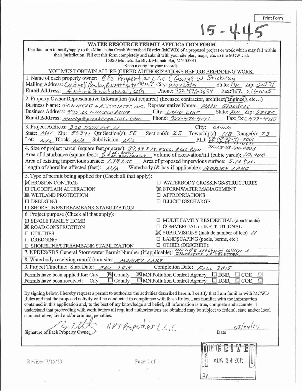
Project: Mooney Lake Preserve Received: Location: 300 Sixth Ave. N., Orono Complete: Noticed:
|
|
|
- Calvin Mosley
- 5 years ago
- Views:
Transcription
1 Permit Application No.: Rules: Erosion Control, Wetland Protection, & Stormwater Management Applicant: BPS Properties, LLC Project: Mooney Lake Preserve Received: Location: 300 Sixth Ave. N., Orono Complete: Noticed: Recommendation: Approval with conditions: Submission of a draft Declaration for maintenance of Wetland Buffers and Stormwater Facilities for MCWD approval, then recordation; Submission of a Financial Assurance in the amount of $11,000.00; Submission of documentation of NPDES permit application and number; and Reimbursement of Fees. And stipulations: The applicant must submit buffer monumentation for approval prior to installation; and The applicant must submit as-built drawings of all stormwater facilities on completion of construction; and The applicant must verify the emergency overflow (EOF) elevation of Wetland 6 against the low opening elevation of the structure to be built on Lot 2 Block 2, to affirm 2 vertical feet of separation from the 100- year high water elevation; Background: BPS Properties, LLC has applied for a Minnehaha Creek Watershed District permit for Erosion Control, Wetland Protection, and Stormwater Management for the construction of an 11-lot subdivision located at 300 Sixth Ave. N. in the City of Orono. The project will result in a 3.72 acre increase in impervious surface on the acre lot, which ultimately drains to Mooney Lake, with 1.55 acres draining to Hadley Lake. The applicant has submitted all exhibits, plans and materials necessary to analyze compliance with the MCWD rules. No variances from MCWD rule provisions are needed for approval of the permit. Rather this permit is before the Board of Managers for determination at the request of a member of the public. In accordance with Resolution delegating permitting authority to staff, staff attempted to meet with the individual who made the request to address concerns about the proposed work. Since the requesting party is a plaintiff in the suit related to the project that is the subject of the permit, MCWD legal counsel attempted to set up an informal meeting between the requesting party and staff to address concerns, but counsel for the party declined. Erosion Control: The District exercises regulatory authority for erosion control in the City of Orono. The District s Erosion Control rule is applicable for any project exceeding 5,000 square feet of land disturbance or 50 cubic yards of excavation. The proposed project involves approximately 8.0 acres of disturbance within the City of Orono, the rule is triggered. The erosion and sediment control practices proposed for the project meet District standards. Erosion and sediment control best management practices (BMPs) provided include: silt fence, bio-logs, rock construction entrances, concrete washout locations, inlet protection, seeding, sodding, and vegetation protection, where applicable. The proposed erosion control plan is consistent with requirements outlined in Section 5 of the District s Erosion Control rule, including: identification of onsite water features; location of trees and vegetation on-site; location of all structures; existing and proposed grading; erosion control measures; existing and proposed stormwater management features; and conforms to all criteria outlined in Section 5(b). The proposed erosion control plan meets the District s Erosion Control rule. Wetland Conservation Act & Wetland Protection: The District exercises regulatory authority for Wetland Protection in the City of Orono. The District administers the Wetland Conservation Act in the City of Orono.
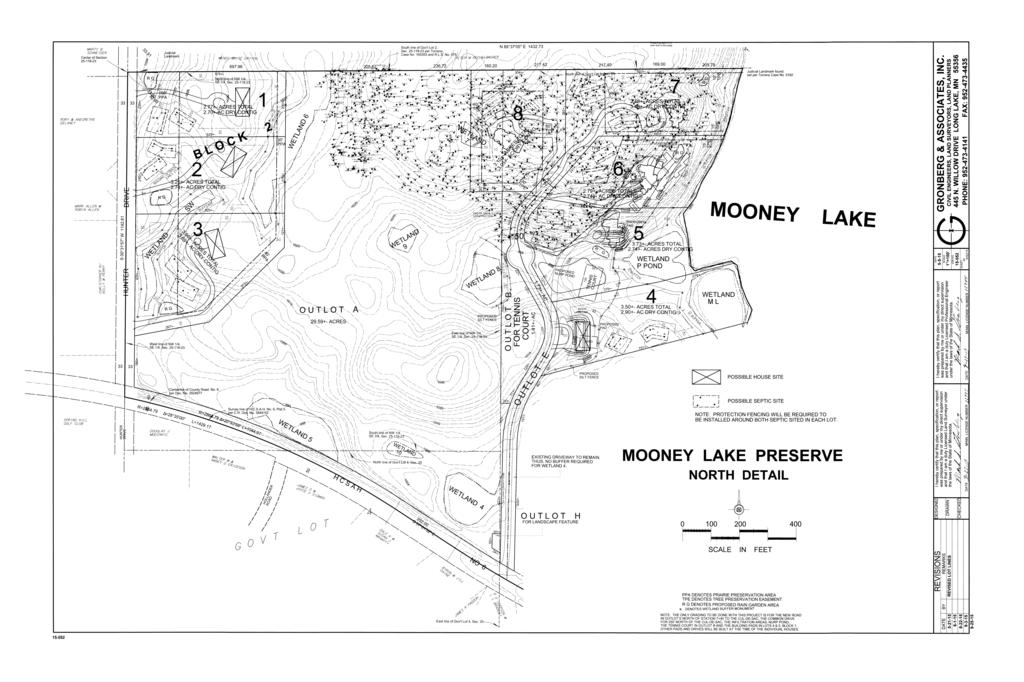
2 A complete Wetland Conservation Act (WCA) wetland boundary & type application (W15-14) for the parcels associated with the above mentioned permit application was submitted to the District on May 21, A WCA Notice of Decision approving the boundaries & types for 14 wetlands on the project parcels was issued on July 10, The proposed redevelopment project does not propose wetland impacts, such as would trigger a need for the applicant to apply for replacement-plan approval under WCA. Because the project triggers the District s Stormwater Management rule, under sections 3(b), 4(a) and 5(a) of the Wetland Protection Rule wetland buffers must be provided on each wetland on the property downgradient from land-disturbing activity to be undertaken for the project. The applicant s plans leave existing wetland buffers undisturbed, therefore the requirements for revegetation of buffer areas in paragraph 7(c) of the rule do not apply. However, in accordance with paragraph 7(a) of the rule, the applicant is required to record a declaration ensuring continued protection and maintenance of the buffer areas. Plans submitted provide for installation of buffer monumentation approved at the required spacing throughout the project area, in accordance paragraph 5(d); the applicant must submit monumentation designs/language for verification by MCWD staff prior to installation. Of the 14 wetlands on the project parcels, eight wetlands are located downgradient of the proposed work. Paragraphs 6(b) and 6(c) of the District s Wetland Protection Rule allow reductions in buffer width when the applicant submits documentation of beneficial slope or soil conditions (Section 6(b)), or demonstrated site constraints (Section 6(c)). The applicant is not proposing reductions in buffer width based on either of these criteria, and is applying the full applicable buffer width as shown in Table 1. The applicant is not utilizing the buffer width averaging provided in paragraph 6(c) of the rule to reduce buffer widths at any location on the project site, and the minimum applied buffer widths in paragraph 6(a) of the rule 16 feet for Manage 3 wetlands, 24 feet for manage 2 wetlands is maintained throughout the project area. Wetland Management Class Base Buffer Width Provided Buffer Width Wetland 1 Manage Wetland 2 Manage Wetland 6 Manage Wetland 7* Manage Wetland 8 Manage Wetland SW Manage Wetland ML Manage Wetland P Manage Table 1:Wetland Buffer Widths *The management class of Wetland 7 was not listed on the District s Functional Assessment of Wetlands inventory; thus, in accordance with the Wetland Protection rule, on August 27 th, 2015 the applicant submitted a Minnesota Routine Assessment Method (MnRAM) report evaluating the management class. The District reviewed and approved the output of the report, which classified the wetland as Manage 2. All wetlands and corresponding buffer areas are depicted in Attachment 5 & 6. The plan meets the District s Wetland Protection rule. Stormwater Management: The District exercises regulatory authority for stormwater management in the City of Orono. The District s Stormwater Management rule is applicable for any project proposing new or replacing existing impervious surface. Because the proposed work constitutes redevelopment involving the addition of 3.72 acres (162,043 square feet) of new impervious surface to the present 1.38 acres of impervious area on a site larger than
3 one acre, paragraph 5(b) of the rule requires the applicant to provide stormwater management meeting the District s stormwater criteria for the entire site area. The table below summarizes the impervious surface increase on-site: Size of Site (ac) Site Drains To Existing Impervious (ac) Proposed Impervious (ac) (8.0 disturbed) Mooney Lake and Hadley Lake Table 2: Increase in Impervious Surface The proposed project will construct two new stormwater ponds (one containing a filtration bench), two infiltration basins, and 9 lot-specific raingardens. All proposed BMPs are designed and will be installed in accordance with generally accepted design practices and guidance of the Minnesota Pollution Control Agency s Minnesota Stormwater Manual. In accordance with Section 3(d) of the District s Stormwater Management rule, BMPs have been incorporated to provide the necessary volume of abstraction through on-site infiltration and peak flow control and to limit pollutant discharge from the site. Paragraph 3(c)(1) of the District s Stormwater Management rule requires an applicant s stormwater management plan to provide for the abstraction of the first one inch of rainfall from the site s impervious surface. Here, that calculation results in a required 18,513 cubic feet of abstraction (i.e., stormwater retained onsite). The submitted stormwater management plan for the project provides an abstraction volume of 20,625 cubic feet of runoff, as shown in Table 3 below. The abstraction volume is provided by the following stormwater practices: Source of Impervious Surface Area (ac) Required Abstraction (cf) Provided Abstraction (cf) BMP Proposed Existing Drive ,333 1,350 Infiltration Basin (south) New West Road and 2 Houses w/ Driveways ,233 3,450 Infiltration Basin (north) New East Road ,300 1,650 Filtration Bench 9 Houses with Driveways ,646 14,175 Raingardens Totals ,513 20,625 Table 3: Abstraction by Stormwater Practice All infiltration practices were designed and sized to draw down within 48 hours. The District s engineer analyzed the design and sizing of the proposed infiltration practices based on the infiltration rates through the soil media, and determined the applicant has met the volume control criteria. The infiltration rates were based on soil information provided by the applicant and soil borings, which match the infiltration rates prescribed by MPCA guidelines. The stormwater-management plan for the project provides phosphorus control by virtue of its meeting the volume control requirement in 3(c)(1). The rate control requirement in paragraph 3(b) of the District s Stormwater Management rule requires no net increase in the peak runoff rate for the 1-, 10-, and 100-year over the site s impervious surface. The proposed stormwater ponds and infiltration practices will reduce runoff below the existing rates for the 1-, 10-, and 100-year TP40 rain events. Thus, in accordance with Section 3(b)(2), no rate increase will occur within any drainage area of the site. The applicant has shown that the criteria of Stormwater rate and volume control were met. After review of HydroCAD calculations, the grading plan, and the location of proposed impervious surfaces, the project as proposed will not increase the bounce and inundation of any wetland or waterbody beyond the limits
4 outlined in the Stormwater Management rule Section 8(b)(1-2). Also, the project does not propose any changes to runout control elevations for any waterbody or wetland which satisfies the criteria of Rule 8(b)(3). Table 4 below lists the pre- and post-construction runoff rates for the proposed disturbed areas at the downgradient site boundaries and discharge locations: Drainage Area 1-year event 10-year event 100-year event Pre- Post- Pre- Post- Pre- Post- Hadley Lake Mooney Lake Total (Disturbed) Table 4: Existing and Proposed Runoff Rates The applicant has also provided analysis showing that the raingardens would provide phosphorus, rate, and volume for each lot. Based upon the elevation of the proposed building pads in relation to adjacent stormwater facilities, wetlands or other waterbodies, all low openings of structures are proposed to have two feet of vertical separation from the 100- year high water elevations, with the exception of the building pad located on Lot 2, Block 2. The criteria of the rule will be met on the stipulation that, the emergency overflow (EOF) elevation of wetland 6 be verified and maintained and the low openings on Lot 2 Block 2 be verified to show 2 feet of vertical separation. The proposed peak runoff rates meet the District s rate-control requirements. The proposed stormwater management system satisfies the District s requirements. Summary: BPS Properties, LLC is proposing an 11-lot subdivision project that will trigger the District s Erosion Control, Wetland Protection, and Stormwater Management rules. The project as proposed meets applicable requirements under each of these District rules. Staff recommends approval of this application with the conditions provided above. Attachments: 1. Permit Application 2. Site Plan North Detail 3. Site Plan South Detail 4. Notice of Decision Approved July 10, Wetland Buffer Plan North 6. Wetland Buffer Plan South Tom Dietrich Date: 10/22/15
5
6
7
8
9
10
11
12
13

14 Memo To: Board of Managers From: Tom Dietrich, Permit & Compliance Coordinator Date: October 19 th, 2015 Re: Board Packet Material for Permit #15-445: Mooney Lake Preserve Managers, Attached is an affidavit and memo that were filed Friday, October 16, on behalf of the plaintiffs in the Healy/Mooney Lake Preserve litigation. (As you know, Minnehaha Creek Watershed District is a defendant.) The affidavit and memo are from Cecilio Olivier of Emmons and Olivier Resources and relate to stormwater management for the proposed redevelopment, which is the subject of permit on the managers agenda for the October 22 meeting. Staff and the MCWD engineer have reviewed the Olivier memo and are preparing a response for the managers review. The responsive memo will be uploaded/delivered as soon as possible, prior to the meeting. In addition, another affidavit and report were filed in the Mooney Lake Preserve litigation Friday, October 16, from Doug Mensing from Applied Ecological Services. The Mensing memo addresses topics that need not be considered by the managers, but one point from the Mensing memo will be addressed by the staff/engineer response: 15. Wetland 7 represents a vernal pool, also known as an ephemeral pool. This type of wetland plays a critical role in the life cycle of certain species, including uncommon species such as salamanders, as well as commoner toads and frogs. Proposed Lot 8 encroaches on this wetland. Land alteration, tree clearing, and runoff from this lot may adversely impact this sensitive and important wetland type. If you have any questions or concerns prior to the October 22 nd meeting, please feel free to contact me. Sincerely, Tom Dietrich Permit & Compliance Coordinator
15
16
17
18
19
20
21
22
23
24
25
26
SUPPORTING DOCUMENT STORMWATER POLLUTION PREVENTION PLAN (SWPPP) NARRATIVE
 NARRATIVE") SUPPORTING DOCUMENT STORMWATER POLLUTION PREVENTION PLAN (SWPPP) NARRATIVE Please complete this narrative form and submit with your SWPPP drawings. Refer to Kitsap County Stormwater Design Manual Vol.
SUPPORTING DOCUMENT STORMWATER POLLUTION PREVENTION PLAN (SWPPP) NARRATIVE Please complete this narrative form and submit with your SWPPP drawings. Refer to Kitsap County Stormwater Design Manual Vol.
16-198/ W16-18 Erosion Control, Wetland Protection, Waterbody Crossings & Structures, & Stormwater Management Irwin Jacobs ity of Orono
 Permit Application No.: 16-198/ W16-18 Rules: Erosion Control, Wetland Protection, Waterbody Crossings & Structures, & Stormwater Management Applicant: Irwin Jacobs/ City of Orono Received:4/26/2016 Project:
Erosion control practices meet District requirements.
 Permit Application No.: 16-631 Rules: Erosion Control, Stormwater Management, Wetland Protection, and Variance Applicant: Woodridge Church Received:11/23/16 Project: Woodridge Church Building Addition
Rule D Wetland and Creek Buffers
 Rule D Wetland and Creek Buffers 1 Policy It is the policy of the Board of Managers to ensure the preservation of the natural resources, recreational, habitat, water treatment and water storage functions
Chapter 4 - Preparation of Stormwater Site Plans
 Chapter 4 - Preparation of Stormwater Site Plans The Stormwater Site Plan is the comprehensive report containing all of the technical information and analysis necessary for the City to evaluate a proposed
Appendix I. Checklists
 Appendix I Checklists Town of Greenwich Drainage Manual Department of Public Works - Engineering Division Town Hall - 101 Field Point Road, Greenwich, CT 06836-2540 Phone 203-622-7767 - Fax 203-622-7747
CHAPTER 9 STORM DRAINAGE. Minimum Requirements for New Development and Redevelopment
 CHAPTER 9 STORM DRAINAGE 9.01 General The standards established by this chapter are intended to represent the minimum standards for the design and construction of storm drainage facilities. 9.02 Design
MANUAL OF DESIGN, INSTALLATION, AND MAINTENANCE REQUIREMENTS FOR STORMWATER MANAGEMENT PLANS
 MANUAL OF DESIGN, INSTALLATION, AND MAINTENANCE REQUIREMENTS FOR STORMWATER MANAGEMENT PLANS May 2007 SECTION 1 Responsibility of Applicant TABLE OF CONTENTS A. Stormwater Management Plan Required Information
Guidance on Preparation of Construction and Maintenance Costs
 INVER GROVE HEIGHTS Northwest Area Appendix F Guidance on Preparation of Construction and Maintenance Costs Northwest Area (NWA) Inver Grove Heights Stormwater Manual Guidance on Preparation of Construction
STORMWATER SITE PLAN INSTRUCTIONS AND SUBMITTAL TEMPLATE Medium and Large Projects
 DEPARTMENT OF COMMUNITY DEVELOPMENT 621 Sheridan Street, Port Townsend, WA 98368 Tel: 360.379.4450 Fax: 360.379.4451 Web: www.co.jefferson.wa.us/communitydevelopment E-mail: dcd@co.jefferson.wa.us STORMWATER
City of Waco Stormwater Management Regulations
 1.0 Applicability: City of Waco Stormwater Management Regulations These regulations apply to all development within the limits of the City of Waco as well as to any subdivisions within the extra territorial
CITY OF TUMWATER 555 ISRAEL RD. SW, TUMWATER, WA (360) (360) (FAX)
 (360) (FAX)") CITY OF TUMWATER 555 ISRAEL RD. SW, TUMWATER, WA 98501 (360) 754-4180 (360) 754-4126 (FAX) Email: cdd@ci.tumwater.wa.us APPENDIX II-C SHORT FORM CONSTRUCTION STORMWATER POLLUTION PREVENTION PLAN (SWPPP)
CITY OF TUMWATER 555 ISRAEL RD. SW, TUMWATER, WA 98501 (360) 754-4180 (360) 754-4126 (FAX) Email: cdd@ci.tumwater.wa.us APPENDIX II-C SHORT FORM CONSTRUCTION STORMWATER POLLUTION PREVENTION PLAN (SWPPP)
Draft Rhode Island Stormwater Design and Installation Standards Manual
 Draft Rhode Island Stormwater Design and Installation Standards Manual Summary The May 2009 Public Review Draft version of the RI Stormwater Design and Installation Standards Manual consists of approximately
Huntington Stormwater Utility
 Huntington Stormwater Utility Stormwater Management & Sediment and Erosion Control Requirements for Construction Sites Authorized by Huntington City Code Articles: 971, 970, 930, 935, 955, Revised April
City of Stoughton Erosion Control Permit Application (effective 2/6/2018)
") City of Stoughton Erosion Control Permit Application (effective 2/6/2018) Incomplete applications will not be accepted Project Name: Address of subject property: Landowner Name(s): Applicant Name: Landowner
City of Stoughton Erosion Control Permit Application (effective 2/6/2018) Incomplete applications will not be accepted Project Name: Address of subject property: Landowner Name(s): Applicant Name: Landowner
STORMWATER PERMIT SUBMITTAL REQUIREMENTS
 STORMWATER PERMIT SUBMITTAL REQUIREMENTS Most development within the City of Bellingham that involves disruption of soils, or construction of buildings, streets, parking lots, etc. requires a Stormwater
Planning the BMP. Region 2000 Planning District Commission Lynchburg, VA December 13, 20013
 Planning the BMP Region 2000 Planning District Commission Lynchburg, VA December 13, 20013 PLANNING THE BMP AGENDA BMP Selection BMP Design SWM Plan Preparation 2 BMP SELECTION Types of BMPs Structural
 Stormwater Management Plan Narrative Quality Fleet Services, Inc. SITE RE-DEVELOPMENT 548 New Ludlow Road South Hadley, MA The project proposed by Quality Fleet Services, Inc. consists of the site improvements
Project Applicant Checklist for NPDES Permit Requirements SAN MATEO COUNTYWIDE STORMWATER POLLUTION PREVENTION PROGRAM
 Project Applicant Checklist for NPDES Permit Requirements SAN MATEO COUNTYWIDE STORMWATER POLLUTION PREVENTION PROGRAM I. PROJECT DATA Project Name Bay Meadows Development Phase II Project Address 2600
TOWNSHIP OF LOGAN SOIL & FILL IMPORTATION AND PLACEMENT APPLICATION SUBMITTAL CHECKLIST
 TOWNSHIP OF LOGAN SOIL & FILL IMPORTATION AND PLACEMENT APPLICATION SUBMITTAL CHECKLIST Applications: 5 copies of application - Applicant will reproduce the copies at his/her costs. The Township Clerk
STORMWATER MANAGEMENT CODES ANALYSIS RICHLAND COUNTY, SC SITE PLANNING ROUNDTABLE
 STORMWATER MANAGEMENT CODES ANALYSIS RICHLAND COUNTY, SC SITE PLANNING ROUNDTABLE Codes analyses for each subcommittee were completed to assist participants of the Richland County Site Planning Roundtable.
5/22/2012. Low Impact Development through NPDES Permits TAKE AWAY MESSAGES. Municipal Stormwater NPDES Permits
 Low Impact Development through NPDES Permits Ed O Brien eobr461@ecy.wa.gov 360/407-6438 TAKE AWAY MESSAGES Municipal SW permits will require LID on new and redevelopment projects Site LID: necessary but
Chapter 3 Site Planning and Low Impact Development
 CHAPTER 3 Site Planning and Low Impact Development Chapter 3 Site Planning and Low Impact Development 3.0 Introduction The City of Charleston requires that major residential, large commercial (>1 acre),
4. Contractor (and subcontractors if applicable) certification statement(s)
 certification statement(s)") CHEMUNG COUNTY STORMWATER COALITION STORMWATER POLLUTION PREVENTION PLAN (SWPPP) SUBMITTAL CHECKLIST GENERAL INFORMATION: 1. Owner/Operator name, legal address, phone number 2. Copy of signed Notice of
CHEMUNG COUNTY STORMWATER COALITION STORMWATER POLLUTION PREVENTION PLAN (SWPPP) SUBMITTAL CHECKLIST GENERAL INFORMATION: 1. Owner/Operator name, legal address, phone number 2. Copy of signed Notice of
STORMWATER REPORT FOR WALMART SUPERCENTER STORE # SIOUX FALLS, LINCOLN COUNTY, SOUTH DAKOTA BFA PROJECT NO
 STORMWATER REPORT FOR WALMART SUPERCENTER STORE # 2443-00 SIOUX FALLS, LINCOLN COUNTY, SOUTH DAKOTA BFA PROJECT NO. 3286 March 1, 2012 I hereby certify that this engineering document was prepared by me
HIGHLAND LAKES WATERSHED ORDINANCE WATER QUALITY MANAGEMENT TECHNICAL MANUAL
 Effective July 1, 2007 HIGHLAND LAKES WATERSHED ORDINANCE WATER QUALITY MANAGEMENT TECHNICAL MANUAL EFFECTIVE JULY 1, 2007 FIFTH EDITION Lower Colorado River Authority TABLE OF CONTENTS DESIGN SPREADHEET
What is stormwater runoff? Why is it a problem? Available Financial Incentives for Stormwater BMP s Downspout Disconnection - up to $20
 What is stormwater runoff? Stormwater is any form of natural precipitation (including ice and snow melt) that flows across undeveloped or developed land. In a natural setting, a majority of the water seeps
Appendix D - Technical Design Criteria for BMPs
 Appendix D - Technical Design Criteria for BMPs City of Wayzata Page 3 On-site infiltration features Definitions and Scope: Infiltration facilities are constructed basins or depressions located in permeable
New Development Stormwater Guidelines
 New Development Stormwater Guidelines CITY OF MOUNTLAKE TERRACE Table of Contents Introduction... 2 Ecology s Minimum Requirements for stormwater management... 2 Description of the 9 Minimum Requirements...
The Restoration of Reading Creek & Model Stream Buffer Ordinances/ Zoning Regulations for Alabama Streams
 The Restoration of Reading Creek & Model Stream Buffer Ordinances/ Zoning Regulations for Alabama Streams Charlene LeBleu, AICP, ASLA, Associate Professor of Landscape Architecture Auburn University Auburn,
ATTACHMENT 1 WILSON MINE LECROY AREA SEMIPERMANENT DEWATERING SYSTEM
 ATTACHMENT 1 WILSON MINE LECROY AREA SEMIPERMANENT DEWATERING SYSTEM Reclamation plans for the Wilson Mine Lecroy area were approved by the Arkansas Department of Environmental Quality with a passive barrier
Zoning Ordinance Article 3
 Article 3 Natural Resources Protection Section 301 Natural Resources Protection 301.1. Purpose - The following natural resources protection standards are established to protect the public health, safety
APPENDIX A SIMPLIFIED APPROACH TO STORMWATER MANAGEMENT FOR SMALL PROJECTS. In West Sadsbury Township, Chester County, Pennsylvania
 APPENDIX A SIMPLIFIED APPROACH TO STORMWATER MANAGEMENT FOR SMALL PROJECTS In West Sadsbury Township, Chester County, Pennsylvania TABLE OF CONTENTS I. Introduction 3 II. Importance of Stormwater Management
5. LOW IMPACT DEVELOPMENT DESIGN STANDARDS
 5. LOW IMPACT DEVELOPMENT DESIGN STANDARDS Low Impact Development (LID) requires a shift in stormwater management away from conveying runoff to a small number of downstream points through hydraulically
CHAPTER 102 REQUIREMENTS CRITCAL STAGES DURING CONSTRUCTION ACTIVITIES
 CHAPTER 102 REQUIREMENTS CRITCAL STAGES DURING CONSTRUCTION ACTIVITIES TOPICS Steps Prior to construction Pre-Construction Meeting Defining the Critical Stages with the Contractor Brady s Run Lake Site
City of Sun Prairie Wetland Buffer Reduction Request
 City of Sun Prairie Wetland Buffer Reduction Request Westside Development Area January 9, 2017 Prepared by: City of Sun Prairie 300 E. Main Street Sun Prairie, WI 53590 BACKGROUND The City of Sun Prairie
PROPOSED DRAINAGE PATTERNS
 1121 1118.50 Basin Floor 1120 1119 0 N 100 200 PROPOSED DRAINAGE PATTERNS Deroiser Drive Riverwood Drive County 260 0 100 200 Project Name: Riverwood Drive LITTLE FALLS TOWNHOMES Project Location: LITTLE
West Virginia Stormwater Management Manual: Methods.
 West Virginia Stormwater Management Manual: Methods Created to deliver targeted training on new tools and practices to improve the quality of stormwater runoff. www.cbstp.org www.chesapeakestormwater.net
Review Zone Application for D&R Canal Commission Decision
 Review Zone Application for D&R Canal Commission Decision MEETING DATE: July 20, 2016 DRCC #: 16-4803 Latest Submission Received: June 13, 2016 Applicant: Robert McCarthy, PE PSE&G 4000 Hadley Road, 2
Action Plan for Retrofitting Structural BMPs
 Action Plan for Retrofitting Structural BMPs Hawaii State Department of Transportation Highways Division, Oahu District Storm Water Management Program NPDES Permit No. HI S000001 August 2014 Action Plan
GENERAL ASSEMBLY OF NORTH CAROLINA SESSION 2007 SESSION LAW SENATE BILL 1967
 GENERAL ASSEMBLY OF NORTH CAROLINA SESSION 2007 SESSION LAW 2008-211 SENATE BILL 1967 AN ACT TO PROVIDE FOR IMPROVEMENTS IN THE MANAGEMENT OF STORMWATER IN THE COASTAL COUNTIES IN ORDER TO PROTECT WATER
CITY OF ST. AUGUSTA STEARNS COUNTY MINNESOTA ORDIANCE NO AN ORDINANCE ESTABLISHING REGULATIONS FOR STORMWATER MANAGEMENT
 CITY OF ST. AUGUSTA STEARNS COUNTY MINNESOTA ORDIANCE NO. 2017-05 AN ORDINANCE ESTABLISHING REGULATIONS FOR STORMWATER MANAGEMENT In the interest of the health, safety, and welfare of its citizens, the
Tour of Nonpoint Source Pollution Reduction Projects in the Western Lake Superior Watershed
 Tour of Nonpoint Source Pollution Reduction Projects in the Western Lake Superior Watershed On September 8 th, 2006 Minnesota's Lake Superior Coastal Program and the South St Louis Soil and Water Conservation
SECTION 11.07: WETLAND BUFFER ORDINANCE
 11.07. Wetland Buffer Ordinance 1.0 Council Findings, Purpose, and Means. SECTION 11.07: WETLAND BUFFER ORDINANCE Section 11.07: Wetland Buffer Ordinance Subdivision 1.0: Council Findings, Purpose, and
WHATCOM COUNTY LID CODE INTEGRATION PROJECT WCC (DEFINITIONS)
") Chapter 20.97 DEFINITIONS Sections: 20.97.029 Best management practice (BMP). 20.97.171.1 Hard surface. 20.97.171.1 2 Hazard tree. 20.97.187 Impervious surface. 20.97.194.1 Land disturbing activity. 20.97.220.1
Chapter 20.97 DEFINITIONS Sections: 20.97.029 Best management practice (BMP). 20.97.171.1 Hard surface. 20.97.171.1 2 Hazard tree. 20.97.187 Impervious surface. 20.97.194.1 Land disturbing activity. 20.97.220.1
Stormwater Drainage Assessment For Single Family Residence
 Stormwater Drainage Assessment For Single Family Residence Project Name: SEADER SFD Project Address: 2301 NE Perkins Way, Lake Forest Park, King County WA. Parcel Number(s): Tax Parcel No. 86659-00181
Minnesota Department of Natural Resource - Natural Resource Guidance Checklist Conserving Natural Resources through Density Bonuses
 Minnesota Department of Natural Resource - Natural Resource Guidance Checklist Conserving Natural Resources through Density Bonuses NRDB Why Use Density Bonuses & This Checklist Local units of government
Coffee Creek Park Development Low Impact Development (LID)
") Coffee Creek Park Development Low Impact Development (LID) City of Duluth, St. Louis County, MN Presented By: Christopher J. Rousseau, P.E. February 27, 2008 Developer / Owner Information Trinity Development
Coffee Creek Park Development Low Impact Development (LID) City of Duluth, St. Louis County, MN Presented By: Christopher J. Rousseau, P.E. February 27, 2008 Developer / Owner Information Trinity Development
Storm Water Quality and Shoreline Restoration Improvements - Grant Funding Request City of Mound Carlson Park Bolton & Menk Project No.
 September 15, 2016 Brett Eidem Cost Share Grant Administrator Minnehaha Creek Watershed District 15320 Minnetonka Boulevard Minnetonka, MN 55345 RE: Storm Water Quality and Shoreline Restoration Improvements
3. Are there any projects exempt from the definition of Regulated Projects?
 STORMWATER REQUIREMENTS: OVERVIEW OF PROVISION C.3 Background: On October 14, 2009, the Regional Water Quality Control Board, San Francisco Bay Region, issued a municipal regional stormwater permit (MRP)
RESIDENTIAL STORM WATER PERMIT & CREDIT APPLICATION WORKSHEET AND CHECKLIST
 Engineering Department - Phone: (651) 792-7004 Fax: (651) 792-7040 2660 Civic Center Dr. Roseville, MN 55113 RESIDENTIAL STORM WATER PERMIT & CREDIT APPLICATION WORKSHEET AND CHECKLIST This application
General Information. Site Conditions. 9b 9b. 9a 1b. Best Management Practices Illustration
 Model Construction SWPPP Planning & Development Services 1800 Continental Place Mount Vernon WA 98273 voice 360-416-1320 inspections 360-416-1330 www.skagitcounty.net/stormwaterpermitting Permit #: General
NPDES - PCSM. Permit Preparation
 NPDES - PCSM National Pollutant Discharge Elimination System Post Construction Stormwater Management Permit Preparation Jim Pillsbury, PE Engineer s Workshop - March 4 and 5, 2010 Who needs NPDES? Earth
Section 3 Non-Structural BMPs
 3.1 Stream Buffers A stream buffer or stream setback is a designated area around a stream, lake, or wetland left in a natural, densely vegetated state so as to protect the receiving water quality and provide
Use of Best Management Practices
 Use of Best Management Practices Presented at the ANJEC Flood Hazard Workshop Bordentown, NJ March 13, 2008 Stormwater BMPs "a technique, measure or structural control that is used for a given set of conditions
PAVING PARKING AREAS AND ROADS DESCRIPTION. Alternate Names: Pavement Practices, Impervious Paving
 4.2-i PAVING PARKING AREAS AND ROADS Alternate Names: Pavement Practices, Impervious Paving DESCRIPTION All roads, driveways, and parking lots proposed for year-round use shall be paved with a hard plowable
SEMSWA s Role in the Land Development Process
 SEMSWA s Role in the Land Development Process One of SEMSWA s responsibilities is to ensure that any new development or redevelopment within its service area is designed and constructed in compliance with
SOP 6: Erosion and Sedimentation Control SOP 6: EROSION AND SEDIMENTATION CONTROL
 Standard Operating Procedures Central Massachusetts Regional Stormwater Coalition SOP 6: Erosion and Sedimentation Control SOP 6: EROSION AND SEDIMENTATION CONTROL Erosion and sedimentation from land-disturbing
LID CASE STUDY DESIGN WORKSHOP HSG B/D SOIL EXAMPLE SINGLE FAMILY SUBDIVISION WITH OUTPARCEL
 LID CASE STUDY DESIGN WORKSHOP HSG B/D SOIL EXAMPLE SINGLE FAMILY SUBDIVISION WITH OUTPARCEL B Y : M A R T Y W A N I E L I S T A A N D E R I C L I V I N G S T O N August, 2016 ACKNOWLEDGEMENTS The Low
Stormwater Retrofitting: The Art of Opportunity. Presented by the Center for Watershed Protection
 Stormwater Retrofitting: The Art of Opportunity Presented by the Center for Watershed Protection What Are Stormwater Retrofits? Retrofits are stormwater management measures inserted in an urban or ultra-urban
Stormwater Technical Guide
 Stormwater Technical Guide Compliance with Stormwater Post-Construction Requirements in Santa Barbara County Dan Cloak, Principal Dan Cloak Environmental Consulting January 9, 2014 Introduce yourself Name
Drainage Control Plans
 2016 Drainage Design and Erosion Control Manual - Guide Sheet 1C Drainage Control Plans A Drainage Control Plan is the comprehensive submittal package containing all of the technical information, analysis,
County of Fairfax, Virginia
 County of Fairfax, Virginia To protect and enrich the quality of life for the people, neighborhoods, and diverse communities of Fairfax County DATE: July 16, 2007 TO: SUBJECT: All Architects, Attorneys,
ARTICLE VI: SITE PLAN REVIEW
 Section 6.01 - Site Plan Review (All Districts) ARTICLE VI: SITE PLAN REVIEW Site plans give the Planning commission an opportunity to review development proposals in a concise and consistent manner. The
Pennsylvania Stormwater Best Management Practices Manual
 Pennsylvania Stormwater Best Management Practices Manual DRAFT - JANUARY 2005 Section 4 Comprehensive Stormwater Management: Integrating Site Design, Non-Structural, and Structural BMP's This page intentionally
Pennsylvania Stormwater Best Management Practices Manual. Chapter 4. Integrating Site Design and Stormwater Management
 Pennsylvania Stormwater Best Management Practices Manual Chapter 4 Integrating Site Design and Stormwater Management 363-0300-002 / December 30, 2006 Chapter 4 Integrating Site Design and Stormwater Management
SITE PLAN REVIEW APPLICATION AND CHECKLIST
 SITE PLAN REVIEW APPLICATION AND CHECKLIST PROJECT SUMMARY: Project Name: City/ETA Location: City ETA (Application fee & number of copies needed are based on location) Property Location (Legal Description
4. CONCEPT PLAN DEVELOPMENT
 4. CONCEPT PLAN DEVELOPMENT Concept Plan Step 1: Identify Site Constraints and Opportunities Review the existing site to identify constraints and opportunities for GI Practices to meet the RRv. Constraints
SIMPLIFIED APPROACH TO STORMWATER MANAGEMENT FOR SMALL PROJECTS
 SIMPLIFIED APPROACH TO STORMWATER MANAGEMENT FOR SMALL PROJECTS Introduction As required by federal and state law, the Borough of Swarthmore has adopted regulations that affect stormwater runoff and surface
STORMWATER GREEN INFRASTRUCTURE AND PLANNING/ZONING BOARDS
 STORMWATER GREEN INFRASTRUCTURE AND PLANNING/ZONING BOARDS Source: Center for Watershed Protection, 2007 Southern Tier Central Regional Planning & Development Board Chemung County Stormwater Team OUTLINE
The Engineer/Developer s Perspective on Storm Water Management
 The Engineer/Developer s Perspective on Storm Water Management CASE STUDY: An Innovative Approach to Storm Water Management for Small Parcel Site Development Presented by: James B. Leedom, P.E. The Sigma
Town of Windham. Planning Department 8 School Road Windham, ME voice fax
 Town of Windham Planning Department 8 School Road Windham, ME 04062 voice 207.864-5960 fax 207.892.1916 MEMO DATE: TO: Staff Review Committee FROM: Amanda Lessard, Planner Cc: Ellen Rathbone, St. Germain
Article 20 Stormwater Management
 Article 20 Section 20.01 Intent Article 20 The purpose of this Article is to protect the health, safety, and general welfare of the citizens by requiring compliance with accepted standards and practices
Lincoln 270. City of Lincoln. Stormwater Management Plan. April 2, 2013
 Lincoln 270 City of Lincoln Stormwater Management Plan April 2, 2013 # 2005.48 Prepared By: Civil Engineering Solutions, Inc. 590 E Street Lincoln, Ca 95648 (916) 645 5700 1.0 Background: The project site
ROGUE VALLEY SEWER SERVICES STORMWATER MANAGEMENT PROGRAM (SWMP)
") ROGUE VALLEY SEWER SERVICES STORMWATER MANAGEMENT PROGRAM (SWMP) 1.0 INTRODUCTION This Stormwater Management Program (SWMP) for Rogue Valley Sewer Services (RVS) has been developed to meet the Municipal
ROGUE VALLEY SEWER SERVICES STORMWATER MANAGEMENT PROGRAM (SWMP) 1.0 INTRODUCTION This Stormwater Management Program (SWMP) for Rogue Valley Sewer Services (RVS) has been developed to meet the Municipal
TOWN OF NORTH CASTLE WESTCHESTER COUNTY 17 Bedford Road Armonk, New York R E S O L U T I O N
 PLANNING BOARD John P. Delano, Chair TOWN OF NORTH CASTLE WESTCHESTER COUNTY 17 Bedford Road Armonk, New York 10504-1898 R E S O L U T I O N Telephone: (914) 273-3542 Fax: (914) 273-3554 www.northcastleny.com
Slow it, Spread it, Sink it using Green Stormwater Infrastructure
 Milly Archer Water Resources Coordinator Becky Tharp Green Infrastructure Collaborative Slow it, Spread it, Sink it using Green Stormwater Infrastructure Overview Defining LID and GSI Hydrology and impacts
DRAFT DESIGN CRITERIA STORMWATER TREATMENT STANDARDS CITY OF OVERLAND PARK
 DRAFT DESIGN CRITERIA STORMWATER TREATMENT STANDARDS CITY OF OVERLAND PARK A. Authority As set forth in the Overland Park Municipal Code (OPMC), Chapter 16.210, the Director of Planning and Development
A. INTRODUCTION AND SUMMARY OF FINDINGS B. EXISTING CONDITIONS. Table 10-1 Adjacent Storm Drains
 Chapter 10: Stormwater Management A. INTRODUCTION AND SUMMARY OF FINDINGS This chapter describes existing and proposed stormwater management on the Site. Potential impacts to stormwater infrastructure
DRAFT SCOPE FOR THE DRAFT ENVIRONMENTAL IMPACT STATEMENT FOR HUDSON HIGHLANDS RESERVE TOWN OF PHILIPSTOWN, NEW YORK June 5, 2018
 DRAFT SCOPE FOR THE DRAFT ENVIRONMENTAL IMPACT STATEMENT FOR HUDSON HIGHLANDS RESERVE TOWN OF PHILIPSTOWN, NEW YORK June 5, 2018 Project Name: Project Location SEQRA Classification of Project: Lead Agency:
Post - Construction Hydromodification Development Requirements
 Condensed Version - Interim Low Impact Development / Hydromodification Guidelines, City of Lompoc 1 Post - Construction Hydromodification Development Requirements I. PURPOSE A. The purpose of these requirements
Community LID Workgroup Issue Paper #6
 Community LID Workgroup Issue Paper #6 Topic: Hard and Impervious Surface Coverage Limits Objective: Minimize the amount of hard and impervious surfaces in developments to allow more stormwater to infiltrate
Lesson 2: Stormwater Best Management Practices (BMPs)
") Lesson 2: Stormwater Best Management Practices (BMPs) Environmental Stewards Class Christopher C. Obropta, Ph.D., P.E. Extension Specialist in Water Resources 732-932-9800 ext. 6209 obropta@envsci.rutgers.edu
Lesson 2: Stormwater Best Management Practices (BMPs) Environmental Stewards Class Christopher C. Obropta, Ph.D., P.E. Extension Specialist in Water Resources 732-932-9800 ext. 6209 obropta@envsci.rutgers.edu
Storm Water Basics for Construction Sites Presented by Representatives from the City of Grass Valley and Nevada County
 September 22nd, 2015 3:30PM Sign up at: www.stormwaterawareness.org Workshop is free! Nevada County Contractor s Association 149 Crown Point Ct. Grass Valley, CA 95945 Storm Water Basics for Construction
HUDSON VALLEY REGIONAL COUNCIL 3 Washington Center, Newburgh NY
 PROJECT AREA: HYDE PARK HUDSON VALLEY REGIONAL COUNCIL 3 Washington Center, Newburgh NY 12550 http://www.hudsonvalleyregionalcouncil Insert aerial site photo with streets labeled GREEN INFRASTRUCTURE CONCEPT
Methods, approaches, and procedures to minimize active agricultural land impacts during pipeline construction, surface restoration, and pipeline
 Agricultural Impact Minimization Plan Methods, approaches, and procedures to minimize active agricultural land impacts during pipeline construction, surface restoration, and pipeline operation. PennEast
Zoning Ordinance Chapter 10
 CHAPTER 10 - WASHES SECTION 10.0 GENERAL: A. The purpose of this Ordinance is to establish standards for development in or near Major and Minor Washes as defined in Appendix A Glossary of Terms and Definitions
Stormwater Fee Credit Manual
 NORTHEAST OHIO REGIONAL SEWER DISTRICT Stormwater Fee Credit Manual June 30, 2010 NEORSD Stormwater Fee Credit Manual June 30, 2010 Table of Contents I. Introduction 1 What is a Stormwater Fee? 2 What
Technical guidance to meet stormwater management design requirements; and,
 Chapter 1. INTRODUCTION 1.1 Purpose of the Manual The purpose of this Stormwater Management Design Manual is to provide engineers, developers, plan reviewers, inspectors, contractors, property owners,
PRELIMINARY STAFF PLANNING REPORT TO THE WALWORTH COUNTY ZONING AGENCY X CONDITIONAL USE
 This report was prepared prior to the public hearing. This report may be supplemented or amended to reflect the review of additional information presented at the public hearing and written material submitted
TO BE FILLED OUT BY APPLICANT
 CITY OF BAINBRIDGE ISLAND CLEARING PERMIT APPLICATION FORM MUST BE COMPLETED IN INK, PREFERABLY BLUE. PENCIL WILL NOT BE ACCEPTED. DATE STAMP FOR CITY USE ONLY PROJECT NAME: TAX ASSESSOR S NUMBER(S): TO
PLANNING COMMISSION Work Session Meeting Agenda
 PLANNING COMMISSION Work Session Meeting Agenda 5200 85TH AVENUE NORTH BROOKLYN PARK MN 55443 PHONE (763) 424-8000 FAX (763) 493-8391 Wednesday, September 27, 2017-7:00 P.M. Brooklyn Township Room If due
Chapter 1: General Program Information
 Chapter 1: General Program Information 1.1 Introduction The Montgomery County Stormwater Management Resolution (#03-1-5) was adopted by the County Board of Commissioners on January 22, 2003. The purpose
Using Runoff Reduction Practices to Shrink the Water Quality Volume (WQv) September 18, 2018 Jay Dorsey
 September 18, 2018 Jay Dorsey") Using Runoff Reduction Practices to Shrink the Water Quality Volume (WQv) September 18, 2018 Jay Dorsey This Presentation Ohio EPA Post-Construction Criteria/Guidance Runoff Reduction Accounting Green
Using Runoff Reduction Practices to Shrink the Water Quality Volume (WQv) September 18, 2018 Jay Dorsey This Presentation Ohio EPA Post-Construction Criteria/Guidance Runoff Reduction Accounting Green
Rain Garden Site Selection and Design. Andrew Anderson, E.I.T. Extension Associate Engineer Biological & Agricultural Engineering NCSU
 Rain Garden Site Selection and Design Andrew Anderson, E.I.T. Extension Associate Engineer Biological & Agricultural Engineering NCSU Outline What to look for around your property How do the soils drain?
Third Ave CSO Integrated Green Infrastructure
 Third Ave CSO Integrated Green Infrastructure Neil Myers Williams Creek Consulting OWEA Annual Conference June 2013 For growing municipalities to be perceived as world class communities, each must move
Shelbyville, KY Stormwater Best Management Practices. Section 2 EROSION PREVENTION AND SEDIMENT CONTROL PLAN
 Section 2 EROSION PREVENTION AND SEDIMENT CONTROL PLAN 2.1 Requirements The City of Shelbyville, KY will require an Erosion Prevention and Sediment Control (EPSC) Plan for most types of development construction.
WQ-23 MOUNTAINOUS AND STEEP SLOPE SITES
 Greenville County Technical Specification for: WQ-23 MOUNTAINOUS AND STEEP SLOPE SITES 1.0 Mountainous and Steep Slope Sites 1.1 Description The geographic locations of portions of Greenville County are
RAIN GARDEN ILLINOIS URBAN MANUAL PRACTICE STANDARD. (feet) CODE 897 DEFINITION
 CODE 897 DEFINITION") ILLINOIS URBAN MANUAL PRACTICE STANDARD RAIN GARDEN (feet) CODE 897 Source: Kendall County Soil and Water Conservation District DEFINITION Rain gardens are small, shallow, flat bottomed depressions constructed
ILLINOIS URBAN MANUAL PRACTICE STANDARD RAIN GARDEN (feet) CODE 897 Source: Kendall County Soil and Water Conservation District DEFINITION Rain gardens are small, shallow, flat bottomed depressions constructed
Regional Stormwater Management Program
 Business Risk Exposure (BRE) Score BTU Community Cost-Share Program (CCSP) Cistern Condition Rating of RSS Asset Criticality of a RSS asset Detention Basin Education Credit Equivalent Residential Unit