RUTGERS UNIVERSITY TRANSPORTATION MASTER PLAN JULY 19, 2017
|
|
|
- Eustace Ford
- 5 years ago
- Views:
Transcription
1 RUTGERS UNIVERSITY TRANSPORTATION MASTER PLAN JULY 19, 2017
2
3
4
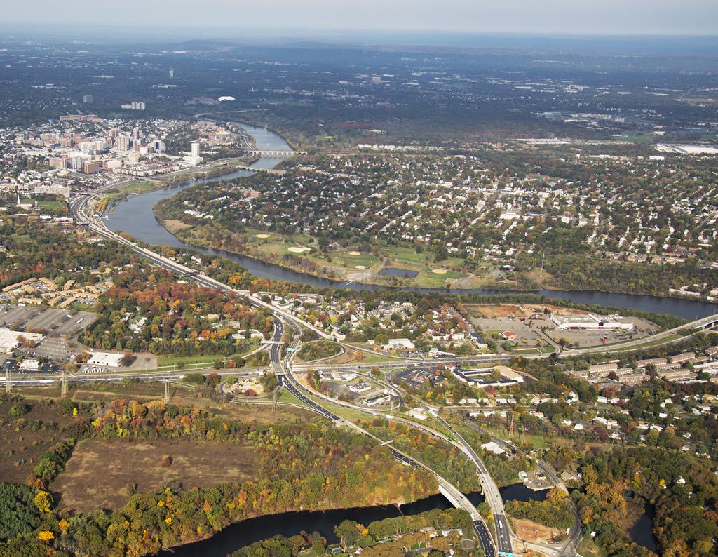
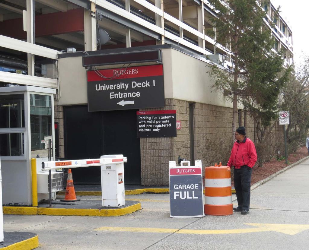
5 On June 18, 2015 Rutgers University s Board of Governors approved a new physical master plan, entitled Rutgers Rutgers 2030 is the first comprehensive master plan to incorporate the Rutgers Biomedical and Health Sciences (RBHS) and was the first comprehensive physical master plan in over a decade for the University. Rutgers 2030 complements the Rutgers University Strategic Plan, and the chancellor-led strategic plans for Rutgers University Camden, Rutgers University Newark, Rutgers University New Brunswick, and Rutgers Biomedical and Health Sciences. Rutgers 2030 envisions development at Rutgers University over a 15 year time frame, , identifies additional development opportunities beyond 2030, and is comprehensive in its scope; taking into account buildings, the natural and constructed landscape, and infrastructure. Rutgers 2030 provides a vision and road map to enhancements that will drive the success of the University into the coming decades. The vision and road map established by Rutgers 2030, with the proposed development, redevelopment and relocations on the campuses have a direct correlation with transportation access, mobility and other transportation related elements such as the university transit service, use of alternate modes of travel, parking demand, among other elements. Integral to the growth envisioned in Rutgers 2030 is how to move people within and among the campuses. Access to, and circulation among and within the campuses is a vital component of the campus experience for students, faculty, staff, and visitors alike. For New Brunswick, the overall size of the campus, spread out locations of various districts, traffic congestion hot spot locations impacting access to and between these districts and geographical features such as the Raritan River, which separates the campus districts are some of the key challenges. For Newark, the congested downtown environment as well as the physical seperation between the Rutgers- and RBHS-Newark are the key challenges. As such, while transportation and mobility are not a core deliverable of the University, they are crucial to meeting academic and research goals. There are many transportation related challenges resulting from distances and connectivity between various campus districts, and these challenges are compounded by regional traffic congestion issues experienced during the peak periods, creating transit service reliability issues and deteriorating user experience. The Rutgers University Transportation Master Plan (RUTMP) focuses on establishing a framework to achieve a holistic resolution of these challenges. It also focuses on advancing various transportation related objectives identified by Rutgers 2030, such as transit hubs and place-making initiatives focused on enhancing student experience such as the Raritan River Multimodal Bridge and Raritan Riverwalk; and by developing conceptual recommendations based on preliminary assessment of various elements (structural and geometric requirements, access considerations, visual /aesthetic effects, and environmental regulatory requirements). The overarching goal of this Rutgers University Transportation Master Plan is to set forth a plan to create a transportation environment that enhances mobility alternatives transit, bicycling, and walking as well as addressing parking for students, faculty, staff and visitors. The transportation planning process examined, in detail, the goals, recommendations, and projects specified in Rutgers 2030 and generated this Transportation Master Plan that assesses existing performance of various transportation elements, estimates the extent of proposed growth and change, identifies the current as well as long-term transportation needs on the Newark and New Brunswick campuses and develops conceptual recommendations to address these needs. The Transportation Master Plan team carefully structured a data-driven analysis and stakeholder outreach based approach as shown in the figure on the following page. ES-3

 CA MP US BUSCH-LIV LA NE ST WE ALLISON ROAD 2-9 BEVIER ROAD 1-6 1-6 12 5 12 4 12 5 12 15 BR ET T RO A D 15 TRANSIT HUB BART")


6 RUTGERS UNIVERSITY TRANSPORTATION MASTER PLAN Transportation Master Plan Approach N TO GS IN TO LIV LIGHTWEIGHT CONC OVERLOOK TERRACE (20 CANTILEVER) ACCESSIBLE ROOF 20 CANTILEVERED GLASS CANOPY BUILT-UP ROOF FOR QUAD ROUTE 18 PEDESTRIAN BRIDGE COLUMN SUPPORT, BEYOND, TYP FOR 2 ROAD RO AD DAVIDSON INGSTON PEDESTRIAN BRIDGE WITH EMBEDDED SNOW-MELT SYSTEM, BEYOND, TYP FOR 2 E BRIDG STATION PYLON AT LEAD BUS DOOR, 18 FROM F.O. CURB ES HO NE W 16-6 (MIN) CA MP US BUSCH-LIV LA NE ST WE ALLISON ROAD 2-9 BEVIER ROAD BR ET T RO A D 15 TRANSIT HUB BART HOLO MEW ROAD LOUNGE AREA 1-6 OFFSET FROM F.O. CURB RO AD BUS QUEUE (5 x 8 ) RAISED 4 MEDIAN PAINTED ASPHALT BIKE LANE RETAIN EXISTING STREET ELEVATION D A RO N FITCH ROAD FR ELIN G HU YS EN EXISTING CENTERLINE OF STREET TO REMAIN BENCH TRASH/RECYCLING RECEPTACLE GEORGE STREET TRANSIT HUB OPTION SECTION ' 0' 4' FEBRUARY 2017 RO AD GEORGE STREET TRANSIT HUB N HE SCARLET KNIGHT WAY CAMPUS Estimate Proposed Growth by Location and Type and Determine Transportation Implications Develop and Refine Transportation and Infrastructure Requirements to Advance Rutgers 2030 Plan Vision Assemble and Review Data Transit Bicycle and Pedestrian Parking Understand Growth and Change Number of Classroom Seats Number of Housing Units/Beds Parking Spaces Recommend Conceptual Transportation/Infrastructure Improvements SU TP Review Rutgers 2030 Plan Assemble and Assess Transportation Data ES-4 Transit Bicycle and Pedestrian Parking

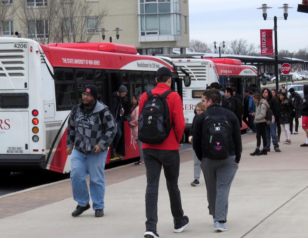
7 Recommendations were centered around the following themes: Transforming the student experience Improving campus connectivity Accommodating all travelers Navigating Rutgers efficiently The recommendations are organized by campus and by travel mode: transit; automobiles and parking; and bicycle and pedestrian improvements. See Section 3 of this report for further details on the Transportation Master Plan approach, themes and stakeholder engagement efforts. It should be noted that the conceptual recommendations contained in this plan are at the master planning level. Further in-depth analysis, review, and design of these recommendations are essential as each of these recommended projects moves through the project development pipeline toward implementation. The Transportation Master Plan is organized by individual districts on the New Brunswick Campus including the RBHS-Downtown New Brunswick and RBHS-Piscataway Districts as well as the Rutgers University-Newark and RBHS-Newark Campuses. The Transportation Master Plan components include: Transit Operations and Infrastructure Existing Transit Operations: assessed existing transit operations based on field observations as well as data analysis using bus boarding video counts; observed actual bus arrival times at key transit stops; identified user wait times; and analyzed NextBus data to understand transit travel times along various routes accompanied by actual travel time runs to determine congestion hotspots and their impacts on transit operations. Existing Transit Ridership: estimated daily transit ridership between campus district pairs based on class schedules and registration data as well as review of actual transit boardings. Future Transit Ridership Projections: estimated based on a quantification of the growth and change anticipated by Rutgers 2030 on various districts and campuses coupled with transit ridership impact assessment of various policy applications such as Course Schedule Planner (CSP) and other technological investments (like synchronous classrooms). Advancement of Rutgers 2030 Transit Infrastructure Vision: assessed geometric, functional and access requirements to develop concept plans and cross-sections for the proposed transit hubs in Rutgers Determination of Transit Infrastructure Improvement Needs: identified conceptual busonly infrastructure needs based on an assessment of reliability issues plaguing existing transit operations caused by external factors, such as traffic congestion, that lead to other issues such as overcrowding on buses. Development Transit Service Improvement Concepts: determined transit service modifications that can improve transit reliability and reduce transit travel time considering the anticipated growth and change proposed by Rutgers 2030 and proposed busonly infrastructure improvements. Identification of Coordination Requirements: identified stakeholders and regulatory agency coordination to advance improvement concepts. ES-5

8 Bicycle Pedestrian Infrastructure and Street Treatments Existing Bicycle and Pedestrian Facilities: identified existing facilities such as bicycle lanes, bicycle parking and repair locations, sidewalks and shared use paths etc. Bicycle and Pedestrian Improvement Concepts: determined location-specific improvement concepts to promote vibrant bicycle and pedestrian activity as envisioned by Rutgers Identification of Coordination Requirements: identified stakeholders and regulatory agencies to advance improvement concepts. Gaps in Bicycle and Pedestrian Networks: determined gaps in bicycle and pedestrian networks that may impact the extent of activity by these modes under existing conditions. Existing Bicycle and Pedestrian Activity: observed existing activity levels during the peak afternoon period on weekdays along with bicycle and pedestrian counts at several key intersections. Development of Street Treatments: developed consistent street treatments across the campuses based on identification of available roadway widths promoting safe accommodation of multiple modes of travel. Advancement of Rutgers 2030 Bicycle and Pedestrian Infrastructure Vision: assessed structural, geometric, functional, access and environmental regulatory requirements to develop Two-Way Separated Bike Lanes 8 Pedestrian Fence Buffer 3 Travel Lane 10 Travel lane 10 Bus Pull Out 8 concept plans and cross-sections for the new Raritan River Multimodal Bridge and Raritan Riverwalk proposed in Rutgers Pedestrian Area ~25 (not to scale) Total Cartway Width 39 ES-6

9 Autos and Parking Intersection Traffic Counts: determined traffic volumes at key intersections during weekday AM and PM peak periods that can be further used to advance roadway improvement concepts into project development and design. Existing Parking Utilization: identified the number of parking spaces by district and campus and assessed existing parking utilization based on weekday afternoon peak period parking utilization surveys. Parking Garage Access: identified appropriate access requirements to streamline vehicular access to the new parking garages to complement the vibrant bicycle and pedestrian friendly district and campus cores envisioned by Rutgers Parking Garage Construction Sequencing: recommended appropriate construction sequencing to ensure availability of sufficient parking supply to meet the parking demand through the construction phase. Identification of Coordination Requirements: identified stakeholders to implement construction of new parking garages. Rutgers 2030 Impacts on Parking: determined impacts on existing parking due to the proposed development in Rutgers 2030 by quantifying number of parking spaces that will either be relocated or will be lost. Future Parking Demand and Supply: estimated future parking demand based on the identified growth and change related to the Rutgers 2030 proposed development and determined how to meet the anticipated demand by providing strategically located parking supplies. Parking Garage Sizing and Location Recommendations: determined the sizing and location for each of the newly proposed parking garages based on future demand estimation and Rutgers 2030 vision. ES-7
10 ES-8
11 Transit: Summary of Conceptual Recommendations Rutgers University- New Brunswick College Avenue, Cook/Douglass, Busch and Livingston Districts RBHS-Downtown New Brunswick and RBHS-Piscataway Rutgers University-Newark RBHS-Newark Initiate coordination with the City of New Brunswick, the County of Middlesex and the New Jersey Department of Transportation (NJDOT) to advance improvement concepts Advance conceptual plans and crosssections prepared for all 5 transit hub locations proposed by Rutgers 2030 to the next phase (final design and engineering) in the implementation process Advance conceptual plans for busonly infrastructure elements (such as Huntington Street Roundabout, NJ Route 18 bus-on-shoulder and busonly ramp etc.) necessary to improve reliability of transit operation by bypassing congestion hotspots to the next phase of project development Initiate transit shuttle service connecting the RBHS Downtown New Brunswick District with potential remote parking locations (such as Busch and/or Livingston Districts) to address surplus parking demand in Downtown New Brunswick Provide a new commuter hub Assess signal coordination improvement potential for University Avenue and Washington Street corridors Continue conducting user surveys at regular intervals to assess future transit service modification needs (recent transit service reorganization is working well) Conduct a detailed origin-destination survey to understand opportunities for improved coordination with Newark Light Rail Initiate coordination with the City of Newark and NJ TRANSIT to advance improvement concepts Provide transit bus stop shelters at the School of Dental Medicine stop and the International Center for Public Health (ICPH) stop Assess potential for providing bus priority treatments for transit service along W. Market Street /Market Street to improve transit travel time and bypass peak period congestion related delays Initiate coordination with the City of Newark and NJ TRANSIT to advance improvement concepts Implement conceptual plans for transit service routing improvements on all districts upon completion of supporting infrastructure improvement needs ES-9
12 ES-10
13 Bicycle and Pedestrian: Summary of Conceptual Recommendations Rutgers University- New Brunswick College Avenue, Cook/Douglass, Busch and Livingston Districts RBHS-Downtown New Brunswick and RBHS-Piscataway Rutgers University-Newark RBHS-Newark Implement street treatment typologies for consistent application across the campus with short-term and longterm applications improving bicycle connectivity within and between districts and pedestrian connectivity within individual districts Advance conceptual plans for the following to the next phases (stakeholder coordination, permitting, design and engineering) towards implementation: Raritan River Multimodal Bridge Raritan Riverwalk College Avenue multimodal improvements Hamilton Street pedestrian improvements Albany Street Bridge improvements for bicycles and pedestrians Implement street treatment typologies for consistent application across the campus with short-term and longterm applications improving bicycle connectivity within and between districts and pedestrian connectivity within individual districts Implement street treatment typologies for consistent application across the campus with short-term and long-term applications improving bicycle connectivity between Rutgers University Newark and Newark Penn Station as well as Rutgers University Newark and RBHS-Newark Advance conceptual plans for the following to the next phases (stakeholder coordination, permitting, design and engineering) towards implementation: Pedestrian upgrades at the intersection of University Avenue and James Street Pedestrian upgrades at the intersection of University Avenue and New Street Bicycle and pedestrian improvements along Central Avenue and at Central Avenue/Park Place and Broad Street intersection Implement street treatment typologies for consistent application across the campus with short-term and long-term applications improving bicycle connectivity between Rutgers University Newark and RBHS- Newark Advance conceptual plans for the following to the next phases (stakeholder coordination, permitting, design and engineering) towards implementation: Bicycle and pedestrian upgrades along 12th Avenue and at the intersection of 12th Avenue and W. Market Street Bicycle and pedestrian upgrades along South Orange Avenue ES-11
14 ES-12
15 Parking: Summary of Conceptual Recommendations Rutgers University- New Brunswick College Avenue, Cook/Douglass, Busch and Livingston Districts RBHS-Downtown New Brunswick and RBHS-Piscataway Rutgers University-Newark RBHS-Newark Provide nine new parking garages with over 5,300 parking spaces as follows: College Avenue District Morell Street Garage: 440 spaces George Street Garage: 375 spaces Student Quadrangle Underground Garage: 375 spaces Cook/Douglass Districts Mason Gross Garage: 625 spaces West Parking Garage: 470 spaces Bush District North Parking Garage: 1,000 spaces South Parking Garage: 750 spaces West Parking Garage: 750 spaces Livingston District Athletics Multiuse Facility Garage: 540 spaces Relocate nearly 3,000 surface parking spaces as a part of Rutgers 2030 Eliminate the need for using leased parking spaces in downtown New Brunswick for RBHS Build 6-level structured parking under the proposed new RBHS expansion space in the RBHS - Downtown New Brunswick District to provide 700 spaces Assess additional need for parking related to increased student presence downtown, to be assessed in subsequent phases of development Accommodate additional parking need for the RBHS - Downtown New Brunswick District with remote parking on Busch and/or Livingston District Provide a new parking garage on Warren Street next to Bradley Hall with1,000 spaces Provide 400 new surface parking spaces identified as a part of the Rutgers 2030 development Accommodate parking need for the proposed private development in the new 12th Avenue Garage with 1,050 spaces Accommodate the parking need for the RBHS development (except the University Hospital and Ambulatory Care Center expansions) by building a parking garage on Parking Lot #1 with 2,250 spaces Parking need for the proposed University Hospital and Ambulatory Care Center expansions is estimated roughly to be 3,000 spaces (locations not identified) - identify locations for additional parking in the subsequent phases of development Any additional parking need to be addressed in the subsequent phases of project development ES-13
Overview and Update of the Rutgers-New Brunswick Physical Master Plan. January 2015
 Overview and Update of the Rutgers-New Brunswick Physical Master Plan January 2015 Failure To Plan, is Planning For Failure Winston Churchill 2 Good Planning; The Key to Success 3 The university physical
Executive Summary. NY 7 / NY 2 Corridor
 Executive Summary NY 7 / NY 2 Corridor Transportation and Land Use Study December 2005 Prepared for: Town of Colonie Capital District Transportation Committee Prepared by: Introduction: Land use decisions
Transportation. Strategies for Action
 Transportation A major priority for the Overlake Neighborhood is to develop a multimodal transportation system. To achieve this system, a balance has to be found among travel, circulation and access needs;
This is the East Carolina University Comprehensive Facilities Master Plan Final Draft Plan Review. This workbook reviews the campus draft master plan
 This is the East Carolina University Comprehensive Facilities Master Plan Final Draft Plan Review. This workbook reviews the campus draft master plan first presented on campus on June 29 and June 30, 2011.
38 Queen s University Campus Master Plan Part 1
 38 Queen s University Campus Master Plan Part 1 46 The Campus at the City Scale Chapter 4 The Campus at the City Scale 39 Queen s is an urban University centrally located in Kingston. Decisions made by
11.0 TRANSPORTATION ELEMENT
 11.0 TRANSPORTATION ELEMENT Transit, Circulation and Parking Sub-Element: For all campuses, FIU's goal is to increase multimodal access. In combination with other measures - such as the development of
Route 1 Corridor Study
 Route 1 Corridor Study Westbrook, Connecticut A Vision for the Connecticut Shoreline Public Informational Meeting July 28, 2015 Lower Connecticut River Valley Council of Governments Fitzgerald & Halliday,
Bus Rapid Transit Backgrounder. December 2016
 Bus Rapid Transit Backgrounder December 2016 Background The City of London is completing the second stage of Shift, its public transit planning exercise. Shift, focuses on rapid transit, along with vehicular
CHAPTER 7: Transportation, Mobility and Circulation
 AGLE AREA COMMUNITY Plan CHAPTER 7 CHAPTER 7: Transportation, Mobility and Circulation Transportation, Mobility and Circulation The purpose of the Transportation, Mobility and Circulation Chapter is to
18 May 2016 CAMPUS MASTER PLAN UPATE
 18 May 2016 CAMPUS MASTER PLAN UPATE Council of the Deans ( Over view) AGENDA Engagement & What We Heard Focus Elements: 1. Development Framework Plan 2. Campus Mobility 3. Campus Guidelines 4. Wayfinding
NorthPoint, Inc. Community-Based Development Concept
 NorthPoint, Inc. Community-Based Development Concept 6.0.01 EXECUTIVE SUMMARY The NorthPoint Community Board Development concept is a community development strategy. It leverages NorthPoint s mission,
New York Avenue Streetscape and Trail Project Public Meeting #1 Summary
 New York Avenue Streetscape and Trail Project Public Meeting #1 Summary I. King Jordan Student Academic Center (SAC) Gallaudet University, Washington, DC February 23, 2017 Table of Contents 1.0 Introduction...
This Review Is Divided Into Two Phases:
 Semiahmoo Town Centre Review The purpose of this review: To review the Semiahmoo Town Centre Concept Plan, originally approved in 1993, to ensure that this centre will continue to serve the needs of South
FDOT D4 Complete Streets
 FDOT D4 Complete Streets Context Sensitive Solutions Directs that complete street solutions will complement the context of the community. Collaborative approach to decision making, project development,
St. Clair Avenue West Area Transportation Master Plan
 1 (Between Keele Street and Old Weston Road) Public Information Centre 1 December 2, 2015 2 Welcome Welcome to the first Public Information Centre for the St. Clair Avenue West Area. The panels will present
Access to the University of North Carolina at Chapel Hill, UNC Hospitals, and Chapel Hill Transit.
 M 1/ 4 1/ 2 E IL M E IL Station Family: County: City: UNC Hospitals WHY THIS STATION? University Village Orange Chapel Hill Access to the University of North Carolina at Chapel Hill, UNC Hospitals, and
Ashland BRT Environmental Assessment: logos of CTA, CDOT, Chicago Department of Housing and Economic Development
 Ashland BRT Environmental Assessment: logos of CTA, CDOT, Chicago Department of Housing and Economic Development Overview The Chicago Transit Authority (CTA), in partnership with the Chicago Department
Shift Rapid Transit Public Participation Meeting May 3, 2017
 Shift Rapid Transit Public Participation Meeting May 3, 2017 Shift Rapid Transit Initiative Largest infrastructure project in the city s history. Rapid Transit initiative will transform London s public
Gold Line Bus Rapid Transit Transit Oriented Development (BRTOD) Helmo Station Area Plan
 Helmo Station Area Plan") Appendix F Gold Line Bus Rapid Transit Transit Oriented Development (BRTOD) Helmo Station Area Plan Introduction and Purpose of the Plan The Gold Line Bus Rapid Transit facility is an eleven-mile dedicated
Appendix F Gold Line Bus Rapid Transit Transit Oriented Development (BRTOD) Helmo Station Area Plan Introduction and Purpose of the Plan The Gold Line Bus Rapid Transit facility is an eleven-mile dedicated
South Davis County COMMUNITY SPOTLIGHT
 South Davis County COMMUNITY SPOTLIGHT Davis/SLC Community Connector Bus Rapid Transit line connecting SLC & Davis County RTP Phase 1 Project Generate 3,100 average weekday riders Relieve congestion on
SPRINGHILL LAKE TRANSIT VILLAGE
 Greenbelt Metro Area Sector Plan - Subarea Design Policies and Guidelines - Springhill Lake Transit Village 113 SPRINGHILL LAKE TRANSIT VILLAGE Residential Neighborhood and Village Center CONCEPT Springhill
Tysons Circulator Study: Process and Preliminary Results Summary. March 2012
 Tysons Circulator Study: Process and Preliminary Results Summary March 2012 Background: 1. The Comprehensive Plan for the Tysons Corner Urban Center calls for a System of Circulators in Tysons Corner to:
12/9/2013. HOLLYWOOD/PINES CORRIDOR PROJECT AMPO 2013 Annual Conference October 24, Our Perspective. Broward.
 HOLLYWOOD/PINES CORRIDOR PROJECT AMPO 2013 Annual Conference October 24, 2013 Our Perspective Broward Fort Lauderdale 1 Broward Metropolitan Planning Organization Fort Lauderdale Fort Lauderdale Skyline
CONNECTING CAMPUS AND COMMUNITY
 CONNECTING CAMPUS AND COMMUNITY Comprehensive Transportation Planning at OSU 2016 Central Ohio Planning and Zoning Workshop // May 20 th Beth Snoke, Director, Transportation and Traffic Management // The
University of Denver Land Use Plan Update I. Executive Summary
 Executive Summary The task of developing a Land Use Plan for the University of Denver has been an exciting collaborative process that engaged a variety of interested people, including members of the University
Welcome. Walk Around. Talk to Us. Write Down Your Comments
 Welcome This is an information meeting introducing the applications for proposed redevelopment of the Yorkdale Shopping Centre site at 3401 Dufferin Street and 1 Yorkdale Road over the next 20+ years,
Chapter 1: Introduction
 Chapter 1: Introduction The Penn Avenue Community Works Corridor Vision and Implementation Framework presents an integrated communitybased vision and a coordinated, long-term implementation framework for
ITEM #8. Regional Smart Growth Program. Regional Smart Growth Program. Presentation Overview. Coast Highway Vision and Stategic Plan.
 Regional Smart Growth Program Economic Development Commission What is Smart Growth? Adopted as part of the Regional Comprehensive Plan (RCP) RCP provides vision for region based on Smart Growth and sustainability
CITY OF CHARLOTTESVILLE, VIRGINIA CITY COUNCIL AGENDA
 CITY OF CHARLOTTESVILLE, VIRGINIA CITY COUNCIL AGENDA Agenda Date: December 16, 2013 Action Required: Adoption of Resolution Presenter: Staff Contacts: Title: James E. Tolbert, AICP, Director of NDS James
City of Farmington. Downtown Plan. Amendment to the 1998 Master Plan Adopted October 11, 2004
 City of Farmington Amendment to the 1998 Master Plan Adopted October 11, 2004 Introduction Planning Background 1 Scope and Components of the Plan Amendment 2 Concept Introduction 3 Plan Concepts 3 Conceptual
Public input has been an important part of the plan development process.
 Lakewood s Comprehensive Plan recognizes that transportation helps shape the community, and that the way the community provides for the safe and efficient movement of people affects the character of the
CAMPUS MASTER PLAN UPATE
 19 MAY 2016 CAMPUS MASTER PLAN UPATE Metropolitan Planning Organization AGENDA Introductions Planning Scope Observation & Analysis: Mobility Systems Campus Development Plan Mobility Planning Scenarios
1.0 INTRODUCTION & BACKGROUND
 1.0 INTRODUCTION & BACKGROUND 1.1 GENERAL The Consulting Team was retained by the City of Edmonton in 2010 to complete a for the replacement of the Walterdale Bridge and the approach roads, as required,
Scope of Services. River Oaks Boulevard (SH 183) Corridor Master Plan
 Corridor Master Plan") Scope of Services River Oaks Boulevard (SH 183) Corridor Master Plan PROJECT AREA The project area consists of the River Oaks Boulevard (SH 183) corridor bounded by SH 199 at the northern end and the Trinity
Scope of Services River Oaks Boulevard (SH 183) Corridor Master Plan PROJECT AREA The project area consists of the River Oaks Boulevard (SH 183) corridor bounded by SH 199 at the northern end and the Trinity
East Bench Master Plan Update
 Community & Economic Development Office of the Director East Bench Master Plan Update To: From: Planning Commission Wayne Mills, Senior Planner Date: November 18, 2015 CC: Re: Nora Shepard, City Planning
John M. Fleming Managing Director, Planning and City Planner. Old East Village Dundas Street Corridor Secondary Plan Draft Terms of Reference
 Report to Planning and Environment Committee To: From: Subject: Chair and Members Planning & Environment Committee John M. Fleming Managing Director, Planning and City Planner Old East Village Dundas Street
TRANSIT-ORIENTED DEVELOPMENT POLICY DRAFT. City Planning and Development Department Kansas City, Missouri
 TRANSIT-ORIENTED DEVELOPMENT POLICY DRAFT City Planning and Development Department Kansas City, Missouri What is Transit Oriented Development (TOD)? Development that focuses land uses around a transit
Issues Requiring Future Study
 Issues Requiring Future Study Transportation planning is an ongoing process that tends to identify new issues as it finds solutions for others. Some issues are so complex that a solution to one problem
Town Center (part of the Comprehensive Plan)
") Town Center (part of the Comprehensive Plan) Mercer Island Town Center Looking North (2014) In 1994, a year-long process culminated in a set of design guidelines and code requirements for the Town Center
Town Center (part of the Comprehensive Plan) Mercer Island Town Center Looking North (2014) In 1994, a year-long process culminated in a set of design guidelines and code requirements for the Town Center
CITY S GOALS DRIVE MODE CHOICE IN WINSTON-SALEM, NC
 CITY S GOALS DRIVE MODE CHOICE IN WINSTON-SALEM, NC Taiwo Jaiyeoba HDR, Transit Principal, Atlanta, GA Claire Brinkley HDR, Transit Planner, Charlotte, NC AGENDA 1. Project Background 2. Project Process
Making Transit Oriented Development Work For Boonton, NJ
 Making Transit Oriented Development Work For Boonton, NJ Bloustein School of Planning and Public Policy Studio Dan Burton Loannie Dao Webster Slater Brandon Williams Ian Watson Maria Laham Nicola Mammes
Gratigny Parkway East Extension Project Development & Environment (PD&E) Study
 Study") Gratigny Parkway East Extension Project Development & Environment (PD&E) Study Session 4: Presentation of Charrette Results December 8, 2010 MDX Work Program #: 92407 ETDM#: 11500 Project Location & Description
Gratigny Parkway East Extension Project Development & Environment (PD&E) Study Session 4: Presentation of Charrette Results December 8, 2010 MDX Work Program #: 92407 ETDM#: 11500 Project Location & Description
Today Land & People. Northeast Nampa Gateway District. Employment. Land Use Characteristics. Demographics. Current Zoning
 Today Land & People Employment Major employers include Saint Alphonsus, the College of Western Idaho, the Auto Mall, Sorrento Lactalis and Walmart. 3,004 jobs in 2010 (COMPASS-CIM 2040 TAZ data) 4,345
Street Flooding Mitigation Plan KYOVA Interstate Planning Commission. Presented to AMPO National Conference October 18, 2017
 Street Flooding Mitigation Plan KYOVA Interstate Planning Commission Presented to AMPO National Conference October 18, 2017 Saleem Salameh, Ph.D., P.E., M.ASCE Chet Parsons, AICP CTP Agenda: Background
Don Mills Crossing Study and Celestica Lands Development Application Community Meeting, Open House, and Breakout Discussions
 Consultation Summary Don Mills Crossing Study and Celestica Lands Development Application Community Meeting, Open House, and Breakout Discussions This report is not intended to provide a verbatim transcript
The Lincoln Neighborhood Corridor Plan. The LiNC
 October 1, 2014 Planning Commission Study Session The Lincoln Neighborhood Corridor Plan The LiNC Purpose of Tonight s Meeting Introduction to The LiNC Review of Existing Conditions and Community Identified
AMITY STATION Revised Concept Plan Review West Rosemary Street Chapel Hill, NC September 27, 2016
 AMITY STATION Revised Concept Plan Review West Rosemary Street Chapel Hill, NC September 27, 2016 DEVELOPER'S PROGRAM Introduction This is a request for review of a Revised Concept Plan by Chapel Hill
WESTERN ILLINOIS UNIVERSITY
 WESTERN ILLINOIS UNIVERSITY Quad Cities Riverfront Campus Preliminary Master Plan Presentation 2 February 1, 2006 Achieving Future Flexibility 1. Monitor space needs as the new buildings come on line and
History: a Grand Urban Boulevard
 History: a Grand Urban Boulevard 1890 1910: At its peak, Euclid Avenue, "Millionaire's Row," was considered the second most beautiful urban street in the country next to Fifth Avenue in Manhattan. 1910-2030:
 Community Workshop #2 December 4, 2014 Team Tonight s Agenda 6:00 pm Welcome! 6:05 pm The Future of Downtown Tustin Ideas, Strategies and Recommendations 6:35 pm Questions and Comments 6:50 pm Open
Town of Oakville Streetscape Strategy
 Town of Oakville Streetscape Strategy Endorsed by PDC on February 10, 2014 (PD-011-14) Town of Oakville Streetscape Strategy [endorsed by PDC February 10, 2014] 0 Town of Oakville Streetscape Strategy
Point A Point B Point C Point D. City of Hapeville Public Meeting July 25, 2017
 City of Hapeville Public Meeting July 25, 2017 Fulton County Transit Master Plan Overview Following last year s ¾-cent TSPLOST effort, the Mayors of the 14 Cities outside of Atlanta and the Fulton County
REPORT TO BOARD ON PREFERENCES tbp/architecture CCSF Facilities Master Plan, October 23, 2016
 PURPOSE The purpose of this report is to update the Board on the Facilities Master Plan initiative. PROCESS The Board conducted a Study Session about Phase 1 Needs on August 18, 2016. Since that time,
The Illinois Department of Transportation and Lake County Division of Transportation. Route 173, including the Millburn Bypass
 The Illinois Department of Transportation and Lake County Division of Transportation welcome you to this Public Hearing for U.S. Route 45 from Illinois Route 132 to Illinois Route 173, including the Millburn
SOUTH UNIVERSITY Street Design Alternatives in Progress
 1 Alternatives in Progress 2016.01.20 Meeting Agenda 2 1. Progress & Schedule 2. Utilizing the Street Design Manual 3. Site Characteristics and Input Received 4. Street Geometry What can we accomplish
FLORIDA STATE UNIVERSITY MASTER PLAN
 TRANSPORTATION ELEMENT NOTE: Unless otherwise noted, the goals, objectives and policies contained in this element shall guide development on the Tallahassee Campus, Southwest Campus and the Panama City
A. INTRODUCTION B. PROJECT LOCATION
 Chapter 1: Project Description A. INTRODUCTION The Lower Manhattan Development Corporation (LMDC), a subsidiary of the New York State Urban Development Corporation, doing business as the Empire State Development
PUBLIC OPEN HOUSE HURONTARIO-MAIN CORRIDOR SECONDARY PLAN
 PUBLIC OPEN HOUSE HURONTARIO-MAIN CORRIDOR SECONDARY PLAN Tuesday, February 28, 2012 6pm 9pm 1 st Floor Atrium, City Hall 2 Wellington Street West, Brampton 1 POLICY FRAMEWORK The 2006 Provincial Growth
LANGAN LANDSCAPE ARCHITECTURE + PLANNING FOR COLLEGES & UNIVERSITIES
 LANGAN LANDSCAPE ARCHITECTURE + PLANNING FOR COLLEGES & UNIVERSITIES CONTACT Philadelphia Pennsylvania 1818 Market Street Suite 3300 Philadelphia PA 19103 215.845.8900 215.845.8901 ST. JOSEPH'S UNIVERSITY
12 February CAMPUS MASTER PLAN UPDATE Focus Group - Wayfinding & Signage
 12 February 2016 CAMPUS MASTER PLAN UPDATE Focus Group - Wayfinding & Signage AGENDA Introductions Planning Scope The 2004 Campus Plan Observations SWOT Exercise Analysis Goals and Advice Questions & Discussion
WELCOME and introduction
 1 WELCOME and introduction Mobility Hub Locations within Burlington STUDY OVERVIEW STUDY OBJECTIVES The City of Burlington is developing four Area Specific Plans, one for each of Burlington s Mobility
Honorable Mayor and Members of the City Council. Submitted by: Eric Angstadt, Director, Planning and Development
 Office of the City Manager ACTION CALENDAR January 29, 2013 To: From: Honorable Mayor and Members of the City Council Christine Daniel, City Manager Submitted by: Eric Angstadt, Director, Planning and
TAC/CAC, TPO Project Update February 2016
 A1A MULTIMODAL CORRIDOR PLANNING AND ENGINEERING ANALYSIS Florida Department of Transportation TAC/CAC, TPO Update February 2016 PRESENTATION FOOTERT Meeting Agenda What We Plan To Discuss Background New
Blue Line LRT Extension
 v e Noble Pkwy Noble Pkwy Xerxes Ave N Shingle Creek Penn Ave N Penn Ave N Fremont Ave N Lyndale Ave N S Washington Ave University Ave NE Blue Line LRT Extension LIGHT RAIL PLATFORM AND STATION DESIGN
Building Great Neighbourhoods. Strathcona
 Building Great Neighbourhoods Strathcona March 21, 2018 Becky Redford Project Manager, Planning & Design Building Great Neighbourhoods Integrated Infrastructure Services Welcome and Purpose To provide
Midtown Corridor Alternatives Analysis. Appendix A - Initially Considered Alternatives Screening
 Midtown Corridor Alternatives Analysis Appendix A - Initially Considered Alternatives Screening Arterial BRT on Lake Street - Overall Rating: RATING Metropolitan Council recommendations stated in the Transportation
Fifth and Detroit Street Design May 2017 Capital Improvements Committee. DOWNTOWN Street Design
 1 Fifth and Detroit Street Design May 2017 Capital Improvements Committee Agenda 2 Review Street Configuration Prior Meeting Review Outreach Synopsis Functional Street Design Refinements Curb Edge, Turning
RESOLUTION NO. R Refining the route, profile and stations for the Downtown Redmond Link Extension
 RESOLUTION NO. R2018-32 Refining the route, profile and stations for the Downtown Redmond Link Extension MEETING: DATE: TYPE OF ACTION: STAFF CONTACT: Capital Committee Board PROPOSED ACTION 09/13/2018
SCTPO Project Summary September 2014
 A1A MULTIMODAL CORRIDOR PLANNING AND ENGINEERING ANALYSIS Florida Department of Transportation SCTPO Project Summary September 2014 PRESENTATION FOOTER Meeting Agenda What We Plan To Do Project Background
Welcome. Comprehensive Plan & Transportation Plan Open House November 7, 2012
 Welcome Comprehensive Plan & Transportation Plan Open House November 7, 2012 Agenda Proposed future land use plan Comprehensive Plan strategies Traffic forecasts Future traffic operations Possible future
TRANSPORTATION ELEMENT
 TRANSPORTATION ELEMENT GOAL I: To create and maintain a safe, efficient and aesthetic transportation system that encourages multi-modal transportation and promotes the mobility strategies of the Ocala
Windsor Locks Transit-Oriented Development Planning Grant Request. Project Background
 Windsor Locks Transit-Oriented Development Planning Grant Request Project Background Downtown Windsor Locks runs along Main Street in the vicinity of the intersection of Routes 159 and 140. The current
REVIEW AND EVALUATION OF REGIONAL LAND USE
 REVIEW AND EVALUATION OF REGIONAL LAND USE AND TRANSPORTATION SCENARIOS #220831 Environmental Justice Task Force October 7, 2014 VISION 2050 Process Development of Guiding Vision for Land Use and Transportation
Phase 1 : Understanding the Campus Context. Phase 2 : APPROACHES - Alternates & Preferred Plan
 Introduction MASTER PLAN PURPOSE WHY A CAMPUS MASTER PLAN? The purpose of the Master Plan at the University of Illinois at Chicago is to translate UIC s strategic goals and objectives into a compelling
This page left intentionally blank.
 July 2012 This page left intentionally blank. Table of Contents Appendix A : Project Development Checklist Appendix B: At-Grade Rail Crossings Appendix C: Maintenance and Operations Examples Appendix D:
Route 347. New York State Department of Transportation Region 10, Long Island. THE GREENING of ROUTE 347
 The GREENING of Route 347 The Greening of Route 347 The Greening of Route 347: History 3 The Greening of Route 347 4 The Greening of Route 347 5 The Greening of Route 347 Smith Haven Mall 6 The Greening
Mississippi Drive Corridor Revitalization. A DestinationTransportation Project...
 Mississippi Drive Corridor Revitalization A DestinationTransportation Project... Mississippi Drive Corridor Revitalization Welcome! Tonight s Agenda: Further define the Scope of the Project Discuss the
Green Line North Centre City Alignment
 Project overview The Green Line will be an important piece of Calgary's transit network, adding 40 kilometres of track to the existing 59 kilometre LRT system. End-to-end, the line will connect North Pointe
The University District envisions, in its neighborhood
 Envisioning the University District Link Light Rail in Seattle s neighborhoods CIY OF SEALE CONCEP-LEVEL SAION AREA PLANNING RECOMMENDAION RESOLUION # 30165 EXHIBI L Vision 08.2000 he University District
Existing Conditions. Planning and Design Principles
 penn s south bank enn s South Bank is located south of the Schuylkill River at the intersection of 4th Street and. This acre former heavy industrial site offers the opportunity to accommodate a variety
GREENING THE BOULEVARD Master Plan Concepts for Venice Boulevard between Lincoln and Sawtelle
 GREENING THE BOULEVARD Katherine Spitz Associates Inc. 4212½ Glencoe Avenue Marina Del Rey, CA 90292 310 574 4460 Fax 574 4462 January 2008 Table of Contents Overview Proposed Design Improvements Illustration
Riverwalk Dreams compiled by Thomas P. Healy November 16, 2017
 Riverwalk Dreams compiled by Thomas P. Healy November 16, 2017 1986 Ripple Village Plan: A neighborhood plan developed by the City of Indianapolis Department of Metropolitan Development s Division of Planning
Study Area. Capitol Way. Greening America s Capitals 11/13/2014. A Greening America s Capitals Project
 Olympia, WA: Greening Capitol Way Supporting Communities move towards sustainability is a priority for the federal government. A Greening America s Capitals Project Office of Sustainable Communities U.S.
10 February CAMPUS MASTER PLAN UPDATE Focus Group - Landscape & Hensel Park
 10 February 2016 CAMPUS MASTER PLAN UPDATE Focus Group - Landscape & Hensel Park AGENDA Introductions Planning Scope The 2004 Campus Plan & Survey Observations 2004 Landscape Plan SWOT Exercise Analysis
July 12, Columbus City Council City Hall 90 West Broad Street Columbus, OH RE: I-70/71 Columbus Crossroads Project
 OHIO DEPARTMENT OF TRANSPORTATION DISTRICT 6 400 EAST WILLIAM STREET DELAWARE, OHIO 43015 800.372.7714 Columbus City Council City Hall 90 West Broad Street Columbus, OH 43215-9015 RE: I-70/71 Columbus
Stadium District Masterplan
 Stadium District Masterplan Masterplan (noun): an evolving long-term planning document that establishes the framework and key elements of a site. It reflects a clear vision synthesizing developer goals
Public Forum. Kelley s Corner: The Corner that Connects Us. The Cecil Group. March 7, Acton 2020 Town of Acton.
 Public Forum Acton 2020 Town of Acton March 7, 2013 AGENDA Purpose of Forum Kelley s Corner Project Examples of the Planning Processes Next Steps Dialogue: Questions and Answers PURPOSE Acton 2020 April
Small Area Plan. South Gateway
 Small Area Plan Adopted May 12, 2008 South Gateway Purpose. The South Gateway Small Area Plan defines the City s expectations for the future of the southern entrance to the City at Interstate 85 and Highway
I-90 ALLSTON INTERCHANGE A MULTIMODAL TRANSPORTATION PROJECT PUBLIC INFORMATION MEETING SEPTEMBER 18, 2014 JACKSON MANN COMMUNITY CENTER
 I-90 ALLSTON INTERCHANGE A MULTIMODAL TRANSPORTATION PROJECT PUBLIC INFORMATION MEETING SEPTEMBER 18, 2014 JACKSON MANN COMMUNITY CENTER 1 Project Need Deteriorating viaduct requiring replacement All Electronic
UNCW CAMPUS MASTER PLAN
 UNCW CAMPUS MASTER PLAN JULY 27, 2017 MASTER PLAN FRAMEWORK RECOMMENDATIONS BOARD OF TRUSTEES PRESENTATION UNCW Campus Master Plan Update Board of Trustees Presentation July 27, 2017 The attached Campus
University of the District of Columbia Van Ness Campus Master Plan Community Open House 3. December 8, 2010
 University of the District of Columbia Van Ness Campus Master Plan Open House 3 December 8, 2010 Introductions Sequence of Work: Campus Master Plan BEGIN: INTRODUCE AND START WORK Project Initiation Team
THAT the attached Terms of Reference for the Thornhill Centre Street Study be approved.
 COMMITTEE OF THE WHOLE AUGUST 18, 2003 THORNHILL CENTRE STREET STUDY PLANNING FILE: 15.92 Recommendation The Commissioner of Planning recommends: THAT the attached Terms of Reference for the Thornhill
UNION STUDIO Greater Kennedy Plaza!
 April May 2013 UNION STUDIO Greater Kennedy Plaza! It s time: Providence s civic plaza and transit hub is re-imagined as a vibrant urban gathering place 1 Kennedy Plaza Reborn THE TEAM Client: The City
CAMPUS MASTER PLAN UPDATE Transportation Element Focus Group Meeting #3
 CAMPUS MASTER PLAN UPDATE 2010-2020 Transportation Element Focus Group Meeting #3 December 2012 5 03 December 2012 1 Campus Master Plan 2010-2020 : Transportation Agenda 1. MMC 2. EC a. Inventory & Analysis
Transit-Oriented Development
 Transit-Oriented Development Path to Sustainability West Windsor February 22, 2007 George S. Hawkins Context for Presentation NJ Future is a non-partisan, 501(c)3 non-profit organization. Offer perspective,
Committee Meeting: Downtown Today & Concept Refinement September 11, 2017
 Committee Meeting: Downtown Today & Concept Refinement September 11, 2017 AGENDA 1. Brief Input Update 2. Comprehensive Plan Principles 3. Downtown Today 4. Concept Updates 5. Future Schedule What is a
LOS ANGELES MISSION COLLEGE MASTER PLAN Master Plan DESIGN & DEVELOPMENT PRINCIPLES
 LOS ANGELES MISSION COLLEGE MASTER PLAN DESIGN & DEVELOPMENT PRINCIPLES 34 Quality Learning Along the Arroyo PROGRAM SUMMARY BY PROJECT The following are program summaries for each of the projects planned
Planning Commission Report
 Planning Commission Report To: From: Subject: Planning Commission Meeting: January 6, 2016 Agenda Item: 8-B Planning Commission David Martin, Planning & Community Development Director Introduction to the
Welcome to the. Open House
 Welcome to the 5th Street to Kinsman Road Open House November 14 5:30 7:00 p.m. Please sign in Project Overview In December 2016, City Council adopted SW 5th Street as the preferred alignment to connect
1 INTRODUCTION Purpose Project Background PROJECT CONTEXT Background The Capital City Downtown Plan...
 Attachment 3 Contents CONTENTS 1 INTRODUCTION... 3 Purpose... 3 Project Background... 3 2 PROJECT CONTEXT... 9 Background... 9 The Capital City Downtown Plan... 9 The LRT Expansion Plan - LRT Downtown