Chain Bridge Road Sidewalk Improvements Citizen Council Work Session
|
|
|
- Julianna Ford
- 5 years ago
- Views:
Transcription


1 Chain Bridge Road Sidewalk Improvements Citizen Council Work Session May 10, 2016

2 Project Location 2
3 Project Objectives Provide a continuous pedestrian facility (sidewalk) connection from Downtown City of Fairfax to Rust Hill Place Eliminate existing erosion/drainage problems and roadside hazards along the west side of Chain Bridge Road within the project limits Provide a context-sensitive design solution that preserves the character of Rust Curve and provides a gateway to the Downtown area 3
4 Progress Overview Design Activities Completed Since Previous Council Presentation in June 2015 Preliminary (50%) Pedestrian Improvement Plan Design Sidewalk, Retaining Wall, Drainage, Barrier Arborist Study & Preliminary Landscape Plan Preliminary Lighting Plan Environmental Coordination & Studies Cultural Resources Study Initial Utility Coordination 4
5 Progress Overview Public Involvement/Community Outreach Three Citizen Committee Meetings September 2015, November 2015, January 2016 Individual Property Owner Meetings City Staff Meetings with Numerous Stakeholders Historic Fairfax City Inc. (HFCI) Fairfax Mews HOA Madison Mews HOA Rustfield HOA Board of Architectural Review (BAR) 5

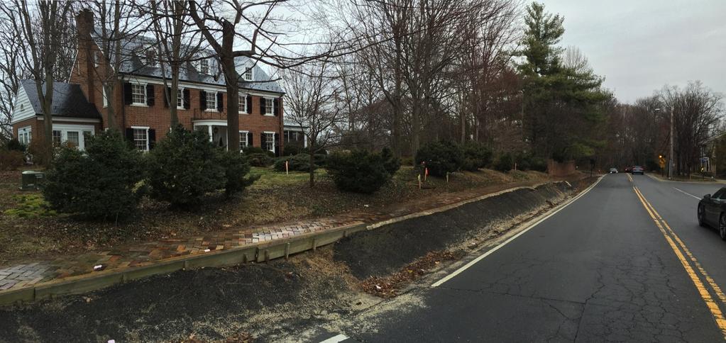
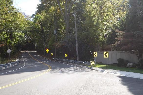
6 Existing Conditions 6

7 Existing Conditions 7

8 Existing Conditions 8

9 Existing Conditions 9
10 Preliminary Design Overview Pedestrian Facilities (Sidewalk) -Americans with Disabilities Act (ADA) compliant sidewalk, curb ramps, and entrance crossings -Typical width of 6 -Variable width buffer separating sidewalk from curb (area for lighting) Drainage Improvements -Curb & gutter and storm sewer system to replace existing roadside ditch, erosion problems, and roadside hazards Utilities -Removal of existing utility poles (west side of road) -Upgrade/replacement of existing waterline 10
11 Preliminary Design Overview Retaining Wall Construction - Required between sidewalk and private properties to minimize property impacts - Aesthetic treatment to enhance visual appearance (brick) - Variable Height (2 to 10 ) Property Impacts - Variable-width Right of Way, Retaining Wall Maintenance, Drainage, and Temporary Construction Easements - Existing trees and landscaping along the roadway frontage 11
12 Preliminary Design Overview Safety Considerations - Buffer between sidewalk and curb - 6 sidewalk adjacent to retaining wall - Barrier between roadway and sidewalk at northern project limits - Pedestrian lighting Project Aesthetics - Treatment for retaining wall - Lighting - Landscaping - Replacement of impacted trees/landscaping/existing fences and walls 12
13 13
14 14

15 Typical Section (Southern End of Project) 15

16 Plan View (Parcel 002 & 003) 16

17 Plan View (Parcel 004 & 005) 17
18 Conceptual Plan Renderings 18
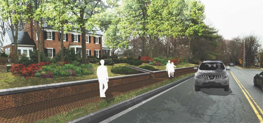
19 Conceptual Plan Renderings 19

20 Typical Section (Middle Section of Project) 20
")
21 Plan View (Parcel 006) 21

22 Conceptual Plan Renderings 22

23 Conceptual Plan Renderings 23

24 Typical Section (Northern End of Project) 24
 25")
25 Plan View (Parcel 008, 009, 010) 25
26 Conceptual Rendering Facing South 26

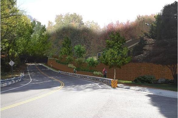
27 Safety Barrier at North End Replace existing guardrail with barrier Aesthetic treatment similar to barrier on Route 123 bridge 27

28 Preliminary Lighting Plan Proposed Gas Street Lights per City of Fairfax PFM to match street lighting in adjacent areas. 28

29 Preliminary Lighting Plan 25 Total Street Lights proposed from parking lot entrance of Moore- McCandlish House to Rust Hill Place. Spaced along the west side of Chain Bridge Road. 29
 April")
30 Cultural Resource Survey Architectural Survey Completed Archaeological Survey Completed 23 Shovel Test Pits (STP) Performed 2 archaeological sites identified No intact features or buried surfaces identified at either site Recommendation of No Adverse Effect submitted to Virginia Department of Historic Resources (VDHR) April

31 Preliminary Planting Plan 31

32 Preliminary Planting Plan 32

33 Preliminary Planting Plan 33

34 Preliminary Planting Plan 34
35 Typical Plant Selection Variety of plantings available Grasses and Perennials Evergreen Shrubs Ornamental Shrubs Small Flowering Trees Large Shade Trees Coordination with individual property owners to occur during final design 35
36 Project Estimate Current Project Estimate is $2.95 M Includes Engineering, Right of Way, Utilities, & Construction Current Project Funding: - RSTP (Federal): $318,317 - Revenue Sharing (State): $1,116,000-30% NVTA (Local Match): $1,116,000 - Total: $2,550,317 (Current Funding Deficit of Approximately $450,000) 36
37 Proposed Project Schedule May 2016 City Council Work Session June 2016 Community Meeting July 2016 City Council Work Session (Optional) September 2016 Formal Public Hearing Winter Finalize Design Summer 2017 Acquire Right of Way/Easements Fall 2017 Utility Relocations Winter Advertise Project for Construction Spring-Fall 2018 Construct Project 37
38 Questions? 38
City of Fairfax, Virginia City Council Work Session
 City of Fairfax, Virginia City Council Work Session Agenda Item # 4a. City Council Meeting 6/2/2015 TO: FROM: SUBJECT: ISSUE(S): SUMMARY: FISCAL IMPACT: RECOMMENDATION: ALTERNATIVE COURSE OF ACTION: RESPONSIBLE
The Illinois Department of Transportation and Lake County Division of Transportation. Route 173, including the Millburn Bypass
 The Illinois Department of Transportation and Lake County Division of Transportation welcome you to this Public Hearing for U.S. Route 45 from Illinois Route 132 to Illinois Route 173, including the Millburn
Project Overview. Get Involved. Public Information Meeting. Contact Information
 Get Involved VDOT representatives will review and evaluate information received as a result of this meeting. Please fill out the comment sheet provided in this brochure if you have any comments or questions.
Citizen Information Meeting
 Prince William County Government Citizen Information Meeting Vint Hill Road Extension May 11, 2016 Benefits: Route 28 Corridor Improvement Program Estimated significant cost savings versus bidding these
IOWA HIGHWAY 57 / WEST 1 ST STREET STUDY PUBLIC INFORMATIONAL MEETING APRIL 22, 2014
 IOWA HIGHWAY 57 / WEST 1 ST STREET STUDY PUBLIC INFORMATIONAL MEETING APRIL 22, 2014 INTRODUCTION The City of Cedar Falls and the Iowa Department of Transportation are conducting a Public Informational
Rt. 29 Solutions Project Delivery Advisory Panel. January 7, 2016
 Rt. 29 Solutions Project Delivery Advisory Panel January 7, 2016 Agenda item 1: Introductions Project Delivery Advisory Panel Technical Team 2 Agenda item 2: Interaction and Feedback Live Streaming Dec
Statement of Intent Proposed Development Five Forks Athletics Scuffletown Rd, Greenville SC
 Statement of Intent Proposed Development Five Forks Athletics Scuffletown Rd, Greenville SC Tax Map #0548020103205 1 P a g e Table of Contents Statement of Intent...page 3-9 Exhibit A Utility Letters Exhibit
Cottage Grove Road Reconstruction. City of Madison Engineering
 Public Informational Meeting Cottage Grove Road Reconstruction October 8, 2015 Presentation Outline Introduction Project Purpose & Need Proposed Design Overview Environmental Concerns Pedestrian Needs
SITE PLAN REVIEW APPLICATION AND CHECKLIST
 SITE PLAN REVIEW APPLICATION AND CHECKLIST PROJECT SUMMARY: Project Name: City/ETA Location: City ETA (Application fee & number of copies needed are based on location) Property Location (Legal Description
PRELIMINARY CONDITIONAL USE SUBMITTAL CHECKLIST REQUIREMENTS
 This checklist must accompany your submittal as the cover page. CONDITIONAL USE Application Submittal Checklist for PRELIMINARY AND FINAL APPROVAL Per Winter Park Land Development Code Sec. 58-90 PRELIMINARY
Highway 12 Sibley Avenue Reconstruction. Project Overview and Progress To Date Litchfield City Council April 17, 2017
 Highway 12 Sibley Avenue Reconstruction Project Overview and Progress To Date Litchfield City Council April 17, 2017 Agenda Item Topic 1) Project Purpose and Need 2) Key Recommendations from Study 3) Preliminary
Prospect Community Plan Update Public Meeting November 2, 2017 OVERVIEW PROSPECT BEAUTIFICATION/CONNECTIVITY PLAN
 Prospect Community Plan Update Public Meeting November 2, 2017 OVERVIEW PROSPECT BEAUTIFICATION/CONNECTIVITY PLAN Presentation Overview Introduction Project History Project Goals/Objectives Project Progress
COMMUNITY DESIGN. GOAL: Create livable and attractive communities. Intent
 COMMUNITY DESIGN Intent An attractive, well-designed County will attract quality development, instill civic pride, improve the visual character of the community, and create a strong, positive image for
SH 199 Corridor Master Plan. Community Meeting No. 2 May 31, 2017
 Community Meeting No. 2 May 31, 2017 Transportation Projects On or Near SH 199 SH 199 from 0.3 miles south of FM 1886 to south end of Lake Worth bridge Construct freeway mainlanes and frontage roads 10-Year
CITY OF DAVIS DESIGN REVIEW INFORMATION CHECKLIST
 CITY OF DAVIS DESIGN REVIEW INFORMATION CHECKLIST The purpose of a design review is comprehensive site plan and architectural review so as to determine compliance with article 40.31 of the Davis Municipal
Urban Planning and Land Use
 Urban Planning and Land Use 701 North 7 th Street, Room 423 Phone: (913) 573-5750 Kansas City, Kansas 66101 Fax: (913) 573-5796 Email: planninginfo@wycokck.org www.wycokck.org/planning To: From: City Planning
VEHICULAR AND PEDESTRIAN CIRCULATION
 This perspective sketch communicates the intended character and quality of a proposed streetscape design. Locate benches near a major intersection where people tend to gather. Seating and lighting provide
Asbury Chapel Subdivision Sketch Plan
 Asbury Chapel Subdivision Sketch Plan PART 1: PROJECT SUMMARY Applicant: NVR Inc. Project Size: +/- 76.13 acres Parcel Numbers: 02101112,02116101,02116112, 02116113 Current Zoning: Transitional Residential
BRADENTON RIVERWALK EXPANSION MASTER PLAN
 BRADENTON RIVERWALK EXPANSION MASTER PLAN INTRODUCTION & AGENDA Process Update Community Engagement Summary Center for Active Design (CfAD) Recommendations Context and Existing Conditions Master Plan Alternatives
Hidden Pointe Landscape Master Plan. June, archi terra
 Hidden Pointe Landscape Master Plan June, 2006 t h e archi terra g r o u p 1 Table of Contents Background Purpose and Goals of the Master Plan Master Plan Process Existing Conditions Entrance Hidden Pointe
7. SITE DESIGN, RETAINING
 7. SITE DESIGN, RETAINING WALLS AND DETENTION 99 CASTLE ROCK DESIGN CASTLE ROCK DESIGN 100 7. SITE DESIGN, RETAINING WALLS AND DETENTION Overview and Goals These guidelines apply to all residential, commercial,
A/E REVIEW CHECKLIST SITE & LANDSCAPE
 A/E REVIEW CHECKLIST SITE & LANDSCAPE Reviewers should - Use Checklists when reviewing any type of VA construction project for the following disciplines: Architectural, Boiler Safety Devices Operation
APPENDIX F: DETAIL DRAWINGS
 APPENDIX F: DETAIL DRAWINGS DRAWING DIVISION 100 GENERAL NOTES 200 ROAD WAYS 300 TRAFFIC CONTROL 400 FENCES 500 SEDIMENT CONTROL 600 SANITARY AND STORM SEWERS 700 WATERMAIN 800 PARKS AND LANDSCAPING 900
November 21, Planning Commission Charter Township of Lyon Grand River Ave. New Hudson, MI 48165
 Planning Commission Charter Township of Lyon 58000 Grand River Ave. New Hudson, MI 48165 Subject: AP-18-68; 11 Mile and Milford Road Park, Site Plan Review #1 Based on site plan dated 11/12/18 Location:
I. DESCRIPTION OF PROPOSED ACTION... 1 A. General Description... 1 B. Historical Resume and Project Status... 2 C. Cost Estimates...
 PROJECT COMMITMENTS SUMMARY... S-1 1. Type of Action... S-1 2. Description of Action... S-1 3. Summary of Purpose and Need... S-1 4. Alternatives Considered... S-2 5. NCDOT Alternatives Carried Forward...
ALLEN CREEK GREENWAY. Citizens Advisory Committee Meeting #5 July 19, Allen Creek Greenway Master Plan. July 2017
 1 ALLEN CREEK GREENWAY MASTER PLAN Citizens Advisory Committee Meeting #5 July 19, 2017 Agenda 2 Final DRAFT Preferred Plan (30 min) Master Plan Document Outline (5 min) Potential Implementation Strategy
The open space system should provide connective elements, relate to natural resources, and enhance the suburban character of the landscape..
 The open space system should provide connective elements, relate to natural resources, and enhance the suburban character of the landscape.. Mixed-use and infill development should maintain or enhance
Public Hearing. Charlotte County-Punta Gorda MPO - Meeting Rooms A and B March 14, open house at 4 p.m., formal presentation at 5 p.m.
 Public Hearing Charlotte County-Punta Gorda MPO - Meeting Rooms A and B March 14, 2019 open house at 4 p.m., formal presentation at 5 p.m. Welcome to the Public Hearing for the Harborview Road (CR 776)
Project Goal. RRRC Living Towns Planning Workshp. Town of Halifax Revitalization Project. Dynamic Planning & Management Duo: July 12, 2006
 Project Goal Town of Halifax Revitalization Project RRRC Living Towns Planning Workshp July 12, 2006 Town of Halifax Halifax County *** Revitalization Project Goal*** To create Economic Opportunity and
Public input has been an important part of the plan development process.
 Lakewood s Comprehensive Plan recognizes that transportation helps shape the community, and that the way the community provides for the safe and efficient movement of people affects the character of the
Maplewood Avenue Downtown Complete Street Project
 Maplewood Avenue Downtown Complete Street Project Second Public Meeting January 24, 2018 Welcome and Introduction of Project Team City Planning and Public Works Staff City of Portsmouth Juliet Walker Planning
WELCOME! 8 8:30 6: TH STREET IMPROVEMENTS. Open House. Presentation & Q&A
 WELCOME! 168 TH STREET IMPROVEMENTS 6:30 Open House 7 8 Presentation & Q&A 8 8:30 Open House WELCOME Todd Pfitzer City of Omaha Engineer Bob Stubbe City of Omaha Public Works Director Jon Meyer Project
PLANNED UNIT DEVELOPMENT & SUBDIVISION STAFF REPORT Date: May 18, 2017
 & PUD-0000102-2017 PLANNED UNIT DEVELOPMENT & SUBDIVISION STAFF REPORT Date: May 18, 2017 NAME SUBDIVISION NAME Dauphin Creek Estates Subdivision Dauphin Creek Estates Subdivision LOCATION CITY COUNCIL
Scope of Services. River Oaks Boulevard (SH 183) Corridor Master Plan
 Corridor Master Plan") Scope of Services River Oaks Boulevard (SH 183) Corridor Master Plan PROJECT AREA The project area consists of the River Oaks Boulevard (SH 183) corridor bounded by SH 199 at the northern end and the Trinity
Scope of Services River Oaks Boulevard (SH 183) Corridor Master Plan PROJECT AREA The project area consists of the River Oaks Boulevard (SH 183) corridor bounded by SH 199 at the northern end and the Trinity
Fairfax County Parkway (Route 286) Widening Project
 Widening Project") Fairfax County Parkway (Route 286) Widening Project Route 29 (Lee Highway) to Route 123 (Ox Road) State Project No. 0286-029-259, P101; UPC 107937 Fairfax Station HOA Meeting January 30, 2018 7:00 to 9:00
Fairfax County Parkway (Route 286) Widening Project Route 29 (Lee Highway) to Route 123 (Ox Road) State Project No. 0286-029-259, P101; UPC 107937 Fairfax Station HOA Meeting January 30, 2018 7:00 to 9:00
SECTION 12 LANDSCAPE
 SECTION 12 LANDSCAPE Landscape and Urban Design provides complete landscape architectural services to the Department for transportation projects. The unit produces landscape design plans, specifications
Toronto Complete Streets Guidelines
 Toronto Complete Streets Guidelines 108 110 7.1 Green Infrastructure Design Principles 112 7.2 Context-Sensitive Green Streets 114 7.3 Key Green Street Elements Green infrastructure refers to natural and
Middlebury RS 0174(8)
") Middlebury RS 0174(8) Preferred Alternative Meeting VT 125 Bridge #13 over Middlebury River August 6, 2012 Presented to Presented by Town of Middlebury VTrans & VHB Introductions: Jennifer Fitch VTrans
Middlebury RS 0174(8) Preferred Alternative Meeting VT 125 Bridge #13 over Middlebury River August 6, 2012 Presented to Presented by Town of Middlebury VTrans & VHB Introductions: Jennifer Fitch VTrans
West Dennis Center: Bass River to Old Main Street. West Dennis Business District: Old Main Street to Dennis Commons
 West Dennis Center: Bass River to Old Main Street West Dennis Business District: Old Main Street to Dennis Commons Dennisport Center: Dennis Commons to Division Street Main Street Project Goals Project
AGENDA ACTION ITEMS INFORMATION ITEMS
 NOACA Bicycle and Pedestrian Advisory Council Meeting Friday, March 21 st, 2014 10:30 a.m. NOACA Office 1299 Superior Avenue Cleveland, Ohio 44114 Phone: (216) 241-2414; website: www.noaca.org AGENDA ACTION
Staff Report Bourbon County Joint Planning Office SPECIAL MEETING September 4, 2018
 Staff Report Bourbon County Joint Planning Office SPECIAL MEETING September 4, 2018 Case Number: DVP 18-05 FINAL Applicant: Josh Cummins Location: Arlington Drive. Request: Car Dealer Parking Lot Zoning:
Century Park to Ellerslie Road Preliminary Engineering
 Century Park to Ellerslie Road Preliminary Engineering South LRT Extension Stakeholder Information Panel Brochure March 2010 www.edmonton.ca/lrtprojects LRT Station (left) and Transit Centre Architectural
City of Manassas Park Proposed Stormwater Management Funding
 City of Manassas Park Proposed Stormwater Management Funding October 5, 2010 State and Federal Storm Water Mandates The State mandates implementation of ordinance, programs, and practices to meet storm
PROJECT SHOWING MINUTES
 PROJECT SHOWING MINUTES North Lynn Street Esplanade Improvements Project No. 0029-000-859, C501, B605 UPC No. 109813 November 1, 2017 10:00 a.m. 1911 North Ft. Myer Drive, LL-10, Arlington, VA Overview
to the Jericho Reservoir Project Open House
 Welcome to the Jericho Reservoir Project Open House is responsible for supplying clean, safe drinking water to over 2.4 million residents in the region. Operating our vast drinking water system with a
The Long Road from Planning to Breaking Ground:
 The Long Road from Planning to Breaking Ground: A Collaboration Between Roanoke County and VDOT Megan G. Cronise, AICP VDOT Coordinating Transportation and Land Use Planning Forum May 10, 2018 Where is
Project Overview. Fairfax County Parkway Widening Fairfax County. Get Involved. Public Information Meeting. Contact Information
 Get Involved VDOT representatives will review and evaluate information received as a result of this meeting. Please fill out the comment sheet provided in this brochure if you have any comments or questions.
The petition proposes the development of five townhomes on a vacant parcel between Charlotte Latin School and Providence Presbyterian Church.
 Rezoning Petition 2017-202 Final Staff Analysis June 18, 2018 REQUEST LOCATION Current Zoning: R-3 (single family residential) Proposed Zoning: UR-2(CD) (urban residential, conditional) with five-year
Alternatives Development Three conceptual alternatives were developed for the Race Road/Jessup Village Planning Study and are described below:
 Race Road/Jessup Village Planning Study (H550601) Project Newsletter Spring 2015 Project Description The Study Team, consisting of staff from Anne Arundel County (Department of Public Works and Department
MEMORANDUM. Jim Tomberlin, Mountain Valley Properties
 MEMORANDUM TO: CC: Jim Tomberlin, Mountain Valley Properties GR Fielding, Pitkin County Engineer Brian Pettit, Pitkin County Public Works Director Dan Cokley, SGM FROM: Lee Barger, SGM DATE: June 16, 2016
The purpose of the requirements in this Article is to provide for landscaping and screening of parking and other outdoor areas that will:
 XIII. LANDSCAPING & SCREENING A. Purpose The purpose of the requirements in this Article is to provide for landscaping and screening of parking and other outdoor areas that will: 1. Protect residential
GPCID Mall Boulevard & Gwinnett Place Drive Complete Street: Sectional View of Concepts
 Sectional View of Concepts PAVEMENT FEATURES PAVEMENTS INTERSECTION INTERSECTION TREATMENTS LANDSCAPE BUFFER LANDSCAPE DESIGN GPCID CD D: GWINNETT P LACE DRIVE & MALL B COMPLETE STREET DESIGN ELEMENTS
SECTION 4(f) DE MINIMIS DOCUMENTATION
 DE MINIMIS DOCUMENTATION") SECTION 4(f) DE MINIMIS DOCUMENTATION Illinois Route 60/83 IL 176 to the intersection of IL 60 (Townline Road) Lake County P-91-084-07 Mundelein Park and Recreation District Project Limit SECTION 4(f)
SECTION 4(f) DE MINIMIS DOCUMENTATION Illinois Route 60/83 IL 176 to the intersection of IL 60 (Townline Road) Lake County P-91-084-07 Mundelein Park and Recreation District Project Limit SECTION 4(f)
Fifth and Detroit Street Design May 2017 Capital Improvements Committee. DOWNTOWN Street Design
 1 Fifth and Detroit Street Design May 2017 Capital Improvements Committee Agenda 2 Review Street Configuration Prior Meeting Review Outreach Synopsis Functional Street Design Refinements Curb Edge, Turning
PLANNING APPROVAL & PLANNED UNIT DEVELOPMENT Date: April 6, 2017
 PLANNING APPROVAL & PLANNED UNIT DEVELOPMENT Date: April 6, 2017 DEVELOPMENT NAME LOCATION Mobile Christian School 5900 Cottage Hill Road (North side of Cottage Hill Road, 230 ± West of Freemont Drive
ROCKAWAY BOARDWALK Community Board 14 Parks Committee Meeting June 4, 2014
 ROCKAWAY BOARDWALK Community Board 14 Parks Committee Meeting June 4, 2014 Introduction 2 Agenda Design Update Construction Update Local Hiring Update 3 Community Input 7 Meeting Date September 17, 2013
4.500 Preston Road Overlay District
 Section 4.500 Preston Road Overlay District 2004 Zoning Ordinance 4.500 Preston Road Overlay District (ZC 98-29; Ordinance No. 98-9-12) 4.501 Purpose To provide appropriate design standards for the use
30% DRAFT GAINSBORO PARK IMPROVEMENT PROJECT THE CITY OF PLEASANT RIDGE CITY OF PLEASANT RIDGE, OAKLAND COUNTY, MICHIGAN
 LEGAL PROPERTY DESCRIPTION SEE NOTES SHEET FOR LEGAL PROPERTY DESCRIPTIONS THE CITY OF PLEASANT RIDGE GAINSBORO PARK IMPROVEMENT PROJECT CITY OF PLEASANT RIDGE, OAKLAND COUNTY, MICHIGAN 4444 Second Avenue
Main Street Reconstruction From Ninth Line to Stouffer Street. Town of Whitchurch-Stouffville. Public Information Centre
 Main Street Reconstruction From Ninth Line to Stouffer Street Town of Whitchurch-Stouffville Public Information Centre November 23, 2016 4:30 to 6:00 pm & 7:00 to 8:00 pm 6240 Main Street, Stouffville
Expo Light Rail Line. Expo Line Community Meeting Phase 2 Design Update November 2011
 Expo Line Community Meeting Phase 2 Design Update November 2011 Meeting Agenda Phase 2 Design Update Meeting Meeting Purpose and Format Project Status Update Overview of Design Progress Next Steps Open
PALO ALTO HIGH SCHOOL Palo Alto Unified School District MEETING NOTES. DATE: 21 September Palo Alto HS Update
 PALO ALTO HIGH SCHOOL Palo Alto Unified School District MEETING NOTES DATE: 21 September 2010 SUBJECT: Landscape Subcommittee Meeting Palo Alto HS Update The purpose of the meeting was to update the Landscape
PLANNING BOARD REPORT PORTLAND, MAINE
 PLANNING BOARD REPORT PORTLAND, MAINE Zero Canal Plaza Development 0 Canal Plaza 2016-162 Cow Plaza 1, LLC Submitted to: Portland Planning Board Date: August 4, 2016 Public Hearing Date: August 9, 2016
The subject site plan amendment proposes the following revisions to the approved site plan:
 PROPOSED AMENDMENT The subject site plan amendment proposes the following revisions to the approved site plan: 1. The building footprint was modified to accommodate the revised architectural design. 2.
Project will Replace: Utilities Curb Pavement Lighting. City of Madison
 Project will Replace: Utilities Curb Pavement Lighting Replace sanitary sewer main & laterals Winnebago: Existing 8 main, 1905 Linden: Existing 6 main, 1915, upsize to 8 main Atwood: Existing 12 main,
SUBMITTAL REQUIREMENTS: FINAL PLAN REVIEW- PROJECT DEVELOPMENT PLAN (PDP)
") 1) Application form and filing fee. Application Form.pdf Development Review Guide STEP 6 of 8 SUBMITTAL REQUIREMENTS: FINAL PLAN REVIEW- PROJECT DEVELOPMENT PLAN (PDP) 2) Transportation Development Review
1) Application form and filing fee. Application Form.pdf Development Review Guide STEP 6 of 8 SUBMITTAL REQUIREMENTS: FINAL PLAN REVIEW- PROJECT DEVELOPMENT PLAN (PDP) 2) Transportation Development Review
MONTGOMERY COUNTY PLANNING DEPARTMENT THE MARYLAND-NATIONAL CAPITAL PARK AND PLANNING COMMISSION
 MONTGOMERY COUNTY PLANNING DEPARTMENT THE MARYLAND-NATIONAL CAPITAL PARK AND PLANNING COMMISSION MCPB Item No. Date: 12-10-15 Leisure World Clubhouse II Addition Fitness Center, Limited Site Plan Amendment
HUNTSVILLE PHYSICAL SERVICES DEPARTMENT
 HUNTSVILLE PHYSICAL SERVICES DEPARTMENT URBAN DEVELOPMENT SITE PLAN CONTROL DRAWING DESIGN GUIDE April, 2000 (Revised June, 2003) TABLE OF CONTENTS Part A. General Information Page 1 Part B. Site Servicing
Capital Projects impacting Odenton Town Center
 Capital Projects impacting Odenton Town Center 1 2 E549700 W801600/ W801602 Anne Arundel County Department of Public Works Manor View Elementary School Transmission Main - MD 32 @ Meade Phase 2 $34,399,000
Item PZ South Lindbergh Project Overview
 Item PZ-042517-01 2001 South Lindbergh Project Overview Project consists of a redevelopment of 2001 South Lindbergh Boulevard, the former Shriner s Hospital site. The site contains 14.871 Acres. The proposed
INFRASTRUCTURE EXISTING INFRASTRUCTURE A. Circulation B. Signals C. Drainage D. Utilities
 7.01. EXISTING INFRASTRUCTURE A. Circulation B. Signals C. Drainage D. Utilities 7.02. PROPOSED INFRASTRUCTURE A. Overall Concept B. Circulation C. Signals D. Drainage 7.03. INFRASTRUCTURE MAP A. Key Infrastructure
P A R K L E T 2016 PILOT PROJECT
 GRAND FORKS, NORTH DAKOTA P A R K L E T 2016 PILOT PROJECT City of Grand Forks Planning & Community Development Department LIVE, LEARN, WORK, PLAY, AND STAY The purpose of the Grand Forks Parklet Application
REPORT TO THE CHIEF ADMINISTRATIVE OFFICER FROM THE DEVELOPMENT AND ENGINEERING SERVICES DEPARTMENT
 REPORT TO THE CHIEF ADMINISTRATIVE OFFICER FROM THE DEVELOPMENT AND ENGINEERING SERVICES DEPARTMENT ON TEMPORARY USE PERMIT NO. TUP00051 DEVELOPMENT PERMIT APPLICATION NO. DPM00557 2793 TRANQUILLE ROAD
VILLAGE OF SPRING LAKE PLANNING COMMISSION. MINUTES REGULAR MEETING April 28, :00 PM
 Page 1 of 6 VILLAGE OF SPRING LAKE PLANNING COMMISSION MINUTES REGULAR MEETING April 28, 2015 7:00 PM Barber School Community Building 102 West Exchange Street Spring Lake, MI 49456 49456 1. CALL TO ORDER
September 28, 2017 Wentworth Avenue (CR 8) Sidewalk Improvements Open House
 Sidewalk Improvements Open House") TIME Anytime from 5:00 PM to 7:00 PM LOCATION City Hall Council Chambers Learn about the project Speak with project representatives Provide input YOU RE INVITED! September 28, 2017 Wentworth Avenue (CR
TIME Anytime from 5:00 PM to 7:00 PM LOCATION City Hall Council Chambers Learn about the project Speak with project representatives Provide input YOU RE INVITED! September 28, 2017 Wentworth Avenue (CR
PLANNED UNIT DEVELOPMENT Date: April 5, 2018
 PLANNED UNIT DEVELOPMENT Date: April 5, 2018 DEVELOPMENT NAME SUBDIVISION NAME LOCATION Robert Myers Robert Myers 2955 and 2989 Dauphin Street (Southeast corner of Dauphin Street and Sage Avenue) CITY
Improve the appearance of off-street parking areas, vehicular use areas, and property abutting public and private roads;
 Bedford Township, MI (Monroe Co.) 2012 http://library.municode.com/index.aspx?clientid=02123 400.1907 - Landscaping and screening. Se 1907. 1. Intent. Landscaping, greenbelts, and screening are necessary
Sanford/Lee County Technical Review Committee (TRC) DEADLINES & MEETING DATES
 DEADLINES & MEETING DATES") Sanford/Lee County Technical Review Committee (TRC) DEADLINES & MEETING DATES The following 2019 information is based on the information available to staff at the time of creation. Dates & time may change
Sanford/Lee County Technical Review Committee (TRC) DEADLINES & MEETING DATES The following 2019 information is based on the information available to staff at the time of creation. Dates & time may change
3.13. Development Guidelines
 3.3 Landscaping Elements Landscaping should be used to frame and soften structures, define site functions, enhance the quality of the environment, and screen undesirable views. Safety, environmental impacts,
I-70/71 Innerbelt Project
 I-70/71 Innerbelt Project Project Progress Meeting and Design Enhancement Update November 9, 2009 Ohio Department of Transportation MS Consultants MSI Design Overview of Presentation 1. Recap Recent Project
CHAPTER 26 LANDSCAPING (Chapter added in its entirety 05-08)
") CHAPTER 26 LANDSCAPING (Chapter added in its entirety 05-08) 26.01 DESCRIPTION AND PURPOSE. Landscaping is an important element of the use, development and preservation of land, and a significant factor
CHAPTER 26 LANDSCAPING (Chapter added in its entirety 05-08) 26.01 DESCRIPTION AND PURPOSE. Landscaping is an important element of the use, development and preservation of land, and a significant factor
DESIGN CRITERIA PACKAGE
 RFQ: 17-C-00003 DESIGN-BUILD SERVICES FOR THE DESIGN CRITERIA PACKAGE PREPARED BY: JAMES E. JACKSON, JR. AIA CITY ARCHITECT CONTRACT ADMINISTRATION DEPARTMENT and INTERFLOW ENGINEERING, L.L.C DESIGN CRITERIA
5.1.1 The streetscape along US Highway 64 (Brevard Road); and, The built environment within new residential developments; and,
; and, The built environment within new residential developments; and,") Article 5. Landscaping 5.1 Purpose The Town of Laurel Park s landscape standards are designed to create a beautiful, aesthetically pleasing built environment that will complement and enhance community
Article 5. Landscaping 5.1 Purpose The Town of Laurel Park s landscape standards are designed to create a beautiful, aesthetically pleasing built environment that will complement and enhance community
Overall Map. Chicago. St. Louis. Summit. Joliet. Dwight. Pontiac. Bloomington-Normal Lincoln. Springfield. Carlinville. Alton EXPERIENCE IT YOURSELF.
 Overall Map Summit Chicago Bloomington-Normal Lincoln New Station Planned New Station Planned Dwight Pontiac Joliet Pedestrian overpass and second platform planned Higher speed service began in this section
HISTORIC LANDMARK COMMISSION STAFF REPORT
 HISTORIC LANDMARK COMMISSION STAFF REPORT Park Strip Raised Planter Boxes Minor Alteration PLNHLC2014-00603 163 D Street Meeting Date: November 6, 2014 Planning Division Department of Community and Economic
STANDARD SPECIFICATIONS Book 2 ENGINEERING DRAWINGS INCLUDES ADDENDUMS
 STANDARD SPECIFICATIONS Book 2 ENGINEERING DRAWINGS INCLUDES ADDENDUMS July 23, 2018 Page 1 of 7 STANDARD LEGEND SYMBOLS (September, 1973)... AS-101A STANDARD LEGEND SYMBOLS (September, 1973)... AS-101B
8 October 14, 2015 Public Hearing
 8 October 14, 2015 Public Hearing APPLICANT & PROPERTY OWNER: PRICE S HOLDINGS, LLC STAFF PLANNER: Karen Lasley REQUEST: A. Conditional Use Permit (Automobile Repair Garage) B. Change in Nonconforming
Neighborhood Conservation (NC) Program CONCEPT DESIGN REVIEW MEETING NOTES
 Program CONCEPT DESIGN REVIEW MEETING NOTES") Neighborhood Conservation (NC) Program CONCEPT DESIGN REVIEW MEETING NOTES PROJECT NAME: PROJECT #: DATE: TO: FROM: 13 th St N Z098 April 8, 2015 (Meeting date March 26 th at 7:00pm) Arlington County Conference
Neighborhood Conservation (NC) Program CONCEPT DESIGN REVIEW MEETING NOTES PROJECT NAME: PROJECT #: DATE: TO: FROM: 13 th St N Z098 April 8, 2015 (Meeting date March 26 th at 7:00pm) Arlington County Conference
To qualify for federal Transportation Enhancement (TE) funds a project must meet two basic federal requirements:
 funds a project must meet two basic federal requirements:") Eligibility Requirements To qualify for federal Transportation Enhancement (TE) funds a project must meet two basic federal requirements: 1) Relate to surface transportation and 2) Be one of the 12 designated
Eligibility Requirements To qualify for federal Transportation Enhancement (TE) funds a project must meet two basic federal requirements: 1) Relate to surface transportation and 2) Be one of the 12 designated
Lower Hill Infrastructure Project Meeting Minutes
 Lower Hill Infrastructure Project Meeting Minutes SUBJECT: Scoping Field View MEETING DATE: January 28, 2014 (Revised 3-17-14 to address comments received from R. Collins, J. Bucher) MEETING TIME: 9:00
Por favor, levanten la mano si necesita traduccion en espanol Please raise your hand if you need Spanish translation
 FEDERAL BOULEVARD CORRIDOR WIDE STUDY PUBLIC MEETING #1 APRIL 27, 2016 Por favor, levanten la mano si necesita traduccion en espanol Please raise your hand if you need Spanish translation HDR DESIGN WORKSHOP
The Community and Transportation Linkage Planning Program
 The Community and Transportation Linkage Planning Program Sandy Misiewicz, AICP Capital District Transportation Committee Senior Transportation Planner II CSS National Dialog 2 October 1, 2013 Capital
Construction and Landscaping on Public Property
 Construction and Landscaping on Public Property City of Manhattan Beach Community Development Department 1400 Highland Avenue 310-802-5504 www.citymb.info January, 2004 Construction and Landscaping on
ROANOKE STREET IMPROVEMENTS CHRISTIANSBURG, VIRGINIA VDOT PROJECT # U R24 UPC #:
 ROANOKE STREET IMPROVEMENTS CHRISTIANSBURG, VIRGINIA VDOT PROJECT # U000-154-R24 UPC #: 108868 VICINITY MAP This project is to be constructed in accordance with the Virginia Department of Transportation
LOCATION AND DESIGN DIVISION
 VIRGINIA DEPARTMENT OF TRANSPORTATION LOCATION AND DESIGN DIVISION INSTRUCTIONAL AND INFORMATIONAL MEMORANDUM GENERAL SUBJECT: Landscape Architecture Program NUMBER: SPECIFIC SUBJECT: Integration of Landscape
Value Engineering Seminar & Design for the Woodroffe Avenue Pedestrian Bridge November 24, 2009
 Value Engineering Seminar & Design for the Woodroffe Avenue Pedestrian Bridge November 24, 2009 Elizabeth Murphy, P.Eng. Sr. Project Manager, City of Ottawa Introduction Algonquin College and the City
REQUEST FOR COUNCIL ACTION 6A AGENDA ITEM
 DATE REQUEST FOR COUNCIL ACTION 6A AGENDA ITEM ORIGINATING DEPT. AGENDA ITEM CITY ADMINISTRATOR APPROVAL Community Development PUD Concept & Development Stage Plan Preliminary Plat & Final Plat PREVIOUS
GREEN SHEET ENVIRONMENTAL COMMITMENTS FOR THE IOWA HIGHWAY 100 EXTENSION
 County: Linn County, IA GREEN SHEET Location: IA 100, from its terminus at Edgewood Rd. to US 30 southwest of Cedar Rapids Route: IA 100 Extension Project No.: NHS-100-1(36) 19-57 OLE Project Managers:
Taché Promenade Tuesday, October 17, 2017
 Welcome to the Public Information Session for the City of Winnipeg s Taché Promenade Tuesday, October 17, 2017 We want to hear from you. Please participate today by: Viewing the recommended design and
APPLICATION BRIEFING Prepared For: Submitted by: Date: Subject:
 Planning & Development APPLICATION BRIEFING Prepared For: Submitted by: Date: Subject: Planning Advisory Committee Jason Fox, Director of Planning & Development Development Agreement application by Godfrey
City of Kearney Capital Improvement Update October 1, TH STREET AND 17TH AVENUE IMPROVEMENTS
 56TH STREET AND 17TH AVENUE IMPROVEMENTS FUNDING: Bonded ESTIMATED COST: $3,885,000 COMPLETION DATE: Fall 2018 SCOPE OF PROJECT: Widening of 56th Street from 6th Avenue to 19th Avenue, and widening 17th