WELCOME! Four Corners and Upper Rio Grande Vulnerability Assessment Webinar Series
|
|
|
- Jared Little
- 5 years ago
- Views:
Transcription


1 WELCOME! Four Corners and Upper Rio Grande Vulnerability Assessment Webinar Series Phone audio: Dial: ; Passcode: # Mute your phone and turn off computer speakers (prevents echo issue). Introduce yourself in the chat box. Webinar recordings will be posted on the Southern Rockies LCC website. Native Fish & Riparian Mule Deer & Elk Sagebrush Ecosystems Pinyon-Juniper Ecosystems


2 United States Department of Agriculture Webinar 3: Results of a Vulnerability Assessment for Sage Steppe Habitat in the Four Corners and Upper Rio Grande Landscapes Mary Williams, Rangeland Ecologist, Rocky Mountain Research Station Megan Friggens, Research Ecologist, Rocky Mountain Research Station

3 Agenda Introduction to Four Corner and Upper Rio Grande Assessments 5 minutes Methods 15 minutes Focal Resource Results 30 minutes Takeaways 5 minutes Q&A 10 minutes

4 Goals for This Webinar Provide overview of assessment results Identify additional datasets/needs Incorporate feedback from today s discussion in preparation for upcoming Adaptation Forums


5 The SRLCC has engaged an adaptive management framework to collaboratively develop shared conservation objectives and landscape scale adaptation strategies Identified Focal Resources and Landscapes Partnered with RMRS to create Vulnerability Assessments for Focal Resources in Two Landscape Spring 2016 Adaptation Forums Fall 2017 Adaptation Forums


6 Focal Resources in 2 Landscapes 1. Streamflow/ Native Fish/ Riparian Corridors 2. Mule Deer & Elk 3. Sage-Steppe Habitat 4. Pinyon-Juniper Woodlands
7 Methods

8 Framework for Landscape Level Vulnerability Assessment of Focal Resources
9 Steps to Quantify Vulnerability 1. Gather data Assess Relevance Assign to Element 2. Create indices 3. Combine E, S, and AC indices to estimate Vulnerability Exposure Impact Sensitivity Vulnerability Adaptive Capacity


10 Step 1. Gather Data Criteria: Spatially explicit Available across focal landscape Meaningful Measurable uncertainty Tried to find datasets used and or produced by LCC stakeholders


11 Challenges with combining existing data Resolution and scale of datasets differ and may not match management needs Uncertainties and assumptions of underlying datasets Uncertainties related to climate projections Linguistic Spatial Scale & Resolution Knowledge Gaps Uncertainties Temporal variation Future trends Method Bias
12 Step 2: Indices Pros Easy to interpret Easy to manipulate on the fly Are able to identify relative differences and more complicated interactions Cons May be biased and/or misleading Not considering differential impacts Assumes equal certainty and quality of underlying data
13 Step 3. From Data to Vulnerability Rank 3. Combine Scaled Impact and Adaptive Capacity Scores Departure T Road density 1. Score each Unit based on original data values Increase=1 Density = top 25 prcnt=1 2. Sum S + E Scores Sensitivity Score Exposure Score Adaptive Capacity Score Potential Impact Vulnerability 1 Very Low 2 Low 3 Moderate 4 High 5 Very High Data Convert (0 1) Add Overlay Map


14 Visualize Vulnerability Vulnerability Impact (E+S) Value Adaptive Capacity Vulnerability Lowest Very Low Low Moderate High Very High

15 Highlight Opportunities Opportunity Adaptive Capacity Impact Opportunity Lowest Intermediate Highest
16 Assessment Results
17 Sagebrush Ecosystems


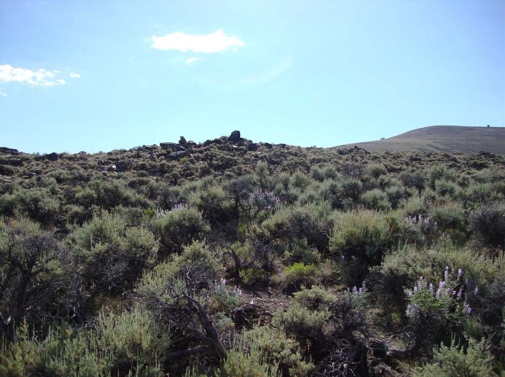
18 BACKGROUND In the focal areas, sagebrush ecosystems represent the southernmost reach of the greater sagebrush biome They are diverse ecosystems of sagebrush, grasses, and forbs; soil crusts are a key element


19 Provide food and cover for wildlife, such as sage grouse, pronghorn, pygmy rabbit, and mule deer Provide cover and nesting sites for obligates, such as sage grouse, Brewer s sparrow, and sagebrush sparrow

20 Existing Conditions Current ecosystems tend to have decadent big sagebrush with cheatgrass understories Overgrazing, invasion by non-native annual grasses, energy development, encroachment by pinyon-juniper, agriculture, and residential development cause departure from desired conditions Shrub removal or thinning, prescribed fire, and revegetation are common practices
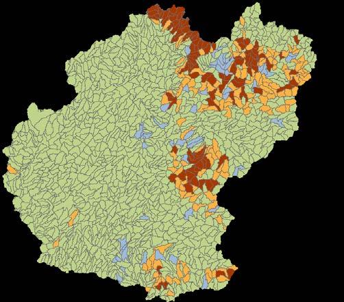
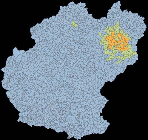
21 Data used Exposure Sensitivity Adaptive Capacity 1. Wildfire Hazard Potential 2. Energy (wells, solar) 3. Change in Development 4. Change in Shrub Cover 5. Change in Crop Cover 6. Vegetation Type Change 1. Terrestrial T and E 2. Wildlife Diversity 3. Pinon-Juniper Interface 4. Development Med-High 5. Road Density 6. Soil Resistance and Resilience, Low 1. Sagebrush Cover 2. Core Areas 3. Public Land Ownership 4. Soil Resistance and Resilience, High
, swisstopo, MapmyIndia, OpenStreetMap")
22 Unit of Analysis Watershed HUC 12 World Topographic Map - Sources: Esri, HERE, DeLorme, Intermap, increment P Corp., GEBCO, USGS, FAO, NPS, NRCAN, GeoBase, IGN, Kadaster NL, Ordnance Survey, Esri Japan, METI, Esri China (Hong Kong), swisstopo, MapmyIndia, OpenStreetMap contributors, and the GIS User Community
23 Relevant data not included in analysis Data/Indicator Conservation Easements Grazing Allotment Departure Population Growth Cropland Conversion Linear Features (fences, power lines) Connectivity Reason Coverage incomplete; some redundancy Coverage incomplete Not compiled yet Not compiled yet; coverage incomplete Not compiled yet Not compiled yet
24 Data: Exposure Description How Used % FC % URG Vegetation Type Change (Peterman et al. 2015) Change in Development, 2040 (USGS 2014) Change in Crop, 2040 (USGS 2014) Change in Shrub, 2040 (USGS 2014) High to Very High Fire Potential (USFS 2014) Energy (oil & gas wells, solar) (ESRI 2015, BLM 2012) Change = Increase = Increase = Decrease = > 20% = Present =


25 Original Data: Exposure, Four Corners


26 Coded Data: Exposure, Four Corners Vegetation type change 0/1 Change in development 0/1 Change in shrub 0/1 Change in crop 0/1 Wildfire hazard potential 0/1 Energy 0/1


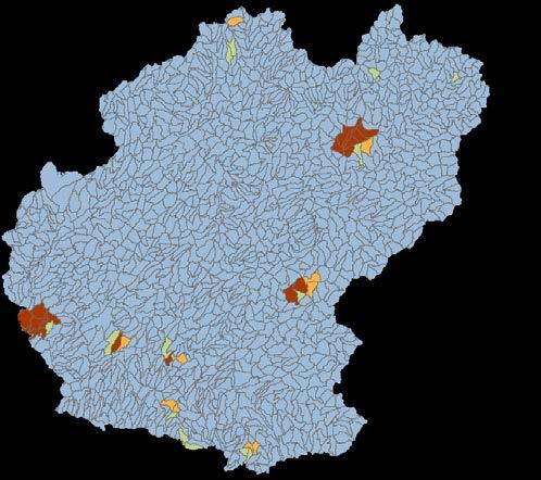
27 Cumulative Exposure: Sagebrush, Four Corners Veg Type Change Fire Hazard Development Change Energy Shrub Change Crop Change

, swisstopo, MapmyIndia, OpenStreetMap")
28 Cumulative Exposure: Sagebrush Four Corners Upper Rio Grande World Topographic Map - Sources: Esri, HERE, DeLorme, Intermap, increment P Corp., GEBCO, USGS, FAO, NPS, NRCAN, GeoBase, IGN, Kadaster NL, Ordnance Survey, Esri Japan, METI, Esri China (Hong Kong), swisstopo, MapmyIndia, OpenStreetMap contributors, and the GIS User Community
29 Data: Sensitivity Description How Used % FC % URG Terrestrial T and E (USFWS 2017) Wildlife Diversity, n=15 (USGS/GAP 2017) Pinon-Juniper Interface (LANDFIRE EVT) Development Med-High (NLCD 2011) Road Density (Tiger 2016) Low Soil Resistance Low Soil Resilience (Chambers 2014,2016, Maestas 2016) Present = > 8 species = > 25 th percentile = 1 (>5%) >25 th percentile = 1 (>0.1%) >25 th percentile = 1 (>0.1 km/km 2 ) Present = 1 Present =


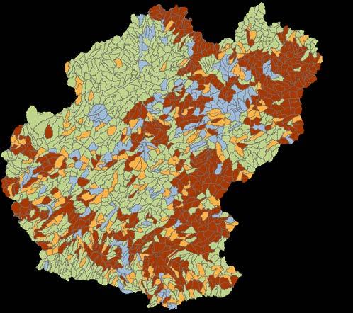
30 Cumulative Sensitivity: Sagebrush Four Corners Upper Rio Grande World Topographic Map - Sources: Esri, HERE, DeLorme, Intermap, increment P Corp., GEBCO, USGS, FAO, NPS, NRCAN, GeoBase, IGN, Kadaster NL, Ordnance Survey, Esri Japan, METI, Esri China (Hong Kong), swisstopo, MapmyIndia, OpenStreetMap contributors, and the GIS User Community
31 Data: Adaptive Capacity Description How Used % FC % URG Sagebrush Cover (LANDFIRE EVT) Core Areas (LANDFIRE EVT) Public Land (USGS PAD 2014) High Soil Resistance High Soil Resilience (Chambers 2014,2016, Maestas 2016) > 25% = >25 th percentile = (>18%) >50% = Present = 1 Present =


32 Cumulative Adaptive Capacity: Sagebrush Four Corners Upper Rio Grande World Topographic Map - Sources: Esri, HERE, DeLorme, Intermap, increment P Corp., GEBCO, USGS, FAO, NPS, NRCAN, GeoBase, IGN, Kadaster NL, Ordnance Survey, Esri Japan, METI, Esri China (Hong Kong), swisstopo, MapmyIndia, OpenStreetMap contributors, and the GIS User Community


33 Calculate Vulnerability Exposure Sensitivity 1. Exposure Score + Sensitivity Score = Impact Score 2. Adaptive Capacity Score + Impact Score = Vulnerability Index Impact Adaptive Capacity World Topographic Map - Sources: Esri, HERE, DeLorme, Intermap, increment P Corp., GEBCO, USGS, FAO, NPS, NRCAN, GeoBase, IGN, Kadaster NL, Ordnance Survey, Esri Japan, METI, Esri China (Hong Kong), swisstopo, MapmyIndia, OpenStreetMap contributors, and the GIS User Community


, swisstopo, MapmyIndia,")
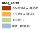
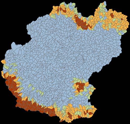
34 Vulnerability Four Corners Upper Rio Grande World Topographic Map - Sources: Esri, HERE, DeLorme, Intermap, increment P Corp., GEBCO, USGS, FAO, NPS, NRCAN, GeoBase, IGN, Kadaster NL, Ordnance Survey, Esri Japan, METI, Esri China (Hong Kong), swisstopo, MapmyIndia, OpenStreetMap contributors, and the GIS User Community
35 Summary: Sagebrush Assessment reveals that >50% of subwatersheds have lower vulnerability scores in each focal area Subwatersheds with higher vulnerability scores occur in the Farmington area and along the Rio Grande corridor Four Corners has slightly more subwatersheds with moderate to high vulnerability scores
36 Takeaways Creating Products to: Estimate Exposure, Sensitivity, and Adaptive Capacity of Focal Resources Assess Vulnerability and Opportunity Identify critical areas of interest, importance, or priority Appropriate Uses: Output cannot support local scale management decisions or conclusions Output can distinguish relative vulnerabilities across landscapes and identify or prioritize: Areas for additional, fine scale study High action needs (e.g. critical threats or sensitivities) Common areas of interest
37 Adaptation Forums Using assessments to identify management priorities How do the results of these assessments match with where you are already working and your current priorities? How do we use this information to move forward to develop collaborative actions and implement LCD?

38 Thank You!
Option 7A Alignment Map. 100-year Floodplain with or without Project
 1-year Floodplain with or without Project New 1-year Floodplain with Project 1-year Floodplain Removed with Project i.e., Benefitted Area) Option 7A Alignment increment P 37ft Corp., GEBCO, USGS,Town FAO,
Transportation Impact Study Technical Working Group (TISTWG) July 1, 2015 Meeting #10 1:30-3:30 PM Agenda
 July 1, 2015 Meeting #10 1:30-3:30 PM Agenda") Transportation Impact Study Technical Working Group (TISTWG) July 1, 2015 Meeting #10 1:30-3:30 PM Agenda 1) Final review and comment on Pro-Rata Share Approach 2) Summary and status of LATR Concepts moving
Transportation Impact Study Technical Working Group (TISTWG) July 1, 2015 Meeting #10 1:30-3:30 PM Agenda 1) Final review and comment on Pro-Rata Share Approach 2) Summary and status of LATR Concepts moving
In November and December, SACOG staff conducted the following Blueprint Implementation land use activities:
 SACOG Board of Directors Item #18-1-16 Receive & File January 11, 2018 Blueprint Implementation Activities The purpose of this item is to regularly inform the Board of SACOG land use related activities
Welcome to the BC Hydro public open house
 Welcome to the BC Hydro public open house West Transmission Project We re here to share the most recent project information and to gather your comments on what we know so far. We hope you ll share your
1 foot of Sea Level Rise
 1 foot of Sea Level Rise Schools Fire Stations Law Enforcement Assisted Living Hospitals 1ft SLR 0 0.35 0.7 1.4 Miles Year 20 Poplation: the 2013 stdy A Geological Perspective U.S. Mid-Atlantic Coast a
water resource specialists
 Vaughn Collins, PE, CFM, Northwest Hydraulic Consultants Brad Livingston, Oregon Department of Transportation Melissa Reich, North Coast Land Conservancy Location Necanicum River 75 sq mi watershed Active
City of Coquitlam Parkland Management Framework
 City of Coquitlam land Management Framework Coquitlam s land Management Framework The City of Coquitlam currently manages approximately 955 hectares (2,359 acres) of parkland that s about double the size
Conservation by Design: Promoting Resilient Coastal Wetlands & Communities. GreatLakesLCC.org
 Conservation by Design: Promoting Resilient Coastal Wetlands & Communities Brent Schleck The Baldwin Group - NOAA Office for Coastal Management ASFPM 6/22/16 GreatLakesLCC.org Overview 2 Great Lakes coastal
Legend. Miles. Fence Removal Location Map for Powdermill 2 and 3. Powdermill Rehab 3 Powdermill Rehab 2 PGC_Roads SGL_Boundary
 ¹ Fence Removal N40.3580 W79.0374 Fence Removal Location Map for Powdermill 2 and 3 SGL 042 Compartment: 2 Cover Stand: 46, 68 Westmoreland County St. Clair Township Hipchain Perimeter 8990 Ft. 42 acres
Information for File # MHK
 Information for File #2014-03555-MHK Applicant: Corps Contact: Wimmer Communities Marie Kopka Address: 250 N. Sunnyslope Road, Suite 296 Brookfield, Wisconsin 53005 E-Mail: Marie.H.Kopka@usace.army.mil
Information for File MVP MMJ; CSAH 10 Reconstruction (Waconia and Watertown Townships)
") Information for File MVP-2014-03830-MMJ; Reconstruction (Waconia and Watertown Townships) Applicant: Carver County Corps Contact: Melissa Jenny Address: 180 Fifth Street East, Suite 700, St. Paul, MN 55101
Information for File MVP-2014-03830-MMJ; Reconstruction (Waconia and Watertown Townships) Applicant: Carver County Corps Contact: Melissa Jenny Address: 180 Fifth Street East, Suite 700, St. Paul, MN 55101
systems is available on the Colorado Wetland Information Center (CWIC) website.
 website.") Colorado Natural Heritage Program Wetland Program Plan -- Dec 2015 Status Update and Addendum -- The Colorado Natural Heritage Program (CNHP) developed a Wetland Program Plan (WPP) in 2010 for the planning
Colorado Natural Heritage Program Wetland Program Plan -- Dec 2015 Status Update and Addendum -- The Colorado Natural Heritage Program (CNHP) developed a Wetland Program Plan (WPP) in 2010 for the planning
New Tools for Land Management: A Quick Introduction to Ecological Site Descriptions
 New Tools for Land : A Quick Introduction to Ecological Site Descriptions Land management agencies have the job of managing natural resources for multiple uses in a sustainable manner. A sound understanding
Next steps Vision and Mission Science Priorities Objective Conservation Framework Actions
 Vision: A conservation community, that while governed by their unique purposes and missions, collaborates on sustaining lands and waters that support natural and cultural resources and the services they
Linked Ecological and Economic State and Transition Model for Adaptive Management of Rangeland Ecosystems
 Linked Ecological and Economic State and Transition Model for Adaptive Management of Rangeland Ecosystems John Ritten 1, Maria E. Fernandez- Gimenez 2, Willow Hibbs 2, Emily Kachergis 3, Windy Kelley 2,
D.M. Wills Associates Limited PARTNERS IN ENGINEERING OSIM Bridge and Culvert Inspection Program. Township of North Frontenac
 2016 OSIM Bridge and Culvert Inspection Program Township of North Frontenac D.M. Wills Project No. 16-9206 D.M. Wills Associates Limited PARTNERS IN ENGINEERING Peterborough February 2017 Prepared for:
BLM s Landscape Approach
 s Landscape Approach s Landscape Approach Conservation Planning in Nevada January 14, 2013 John M Wilson Healthy Landscapes Program Lead, Nevada Purpose of Today s Discussion Provide an overview of the
Great Lakes Conservation Blueprint for Terrestrial Biodiversity on the Canadian Shield
 Great Lakes Conservation Blueprint for Terrestrial Biodiversity on the Canadian Shield Bonnie L. Henson 1, Kara E. Brodribb 2 and John L. Riley 3 1 Ontario Ministry of Natural Resources 2,3 The Nature
CITY OF VACAVILLE PLANNING COMMISSION Item No. 8.A STAFF REPORT July 18, 2016 STAFF CONTACT: Amy Feagans, Contract Planner (707)
") CITY OF VACAVILLE PLANNING COMMISSION Item No. 8.A STAFF REPORT July 18, 2016 STAFF CONTACT: Amy Feagans, Contract Planner (707) 449-5140 TITLE: THE FARM AT ALAMO CREEK ENVIRONMENTAL IMPACT REPORT (EIR)
CITY OF VACAVILLE PLANNING COMMISSION Item No. 8.A STAFF REPORT July 18, 2016 STAFF CONTACT: Amy Feagans, Contract Planner (707) 449-5140 TITLE: THE FARM AT ALAMO CREEK ENVIRONMENTAL IMPACT REPORT (EIR)
Wallace Country Acreage
 Wallace Country Acreage A stunning brick home surrounded by beautiful landscaping and picturesque views of the Nebraska plains Email: Jordan@lashleyland.com Property Highlights List Price $500,000 Location
JOINT PUBLIC NOTICE. 26 June United States Army Corps of Engineers State of Louisiana
 JOINT PUBLIC NOTICE 26 June 2017 United States Army Corps of Engineers State of Louisiana New Orleans District Department of Environmental Quality Regulatory Branch Office of Environmental Services 7400
GIS to Estimate Archaeological Site Loss and Develop Conservation Strategies
 GIS to Estimate Archaeological Site Loss and Develop Conservation Strategies Terry Jackson Office of Decision Support Systems Planning and Environmental Management Division Georgia Department of Community
Mountain Loam STM T2R T2R. Mt. Big Sagebrush- Diverse Understory. Mt. Big Sagebrush- Wheatgrass Shrubland
 Mountain Loam STM T2 Diverse Understory T2R Wheatgrass Shrubland T1 T1R T3 Dense or Eroding Mt. Big Sagebrush- Shrubland Diverse Understory 1934 lbs/acre Species richness: 41.4 Invasives: 0% Erosiveness:
EXHIBIT C. Flow-Control BMP Monitoring Site Selection Technical Memorandum
 EXHIBIT C Flow-Control BMP Monitoring Site Selection Technical Memorandum 550 Kearny Street Suite 800 San Francisco, CA 94108 415.896.5900 phone 415.896.0332 fax www.esassoc.com memorandum date June 26,
Nearby Features (Water body, T&E Habitat, Wetlands, Noxious Weed):
:") Variance Request Form Company: Avangrid Renewables Variance: VAR-016 Address: 1125 NW Couch Street, Suite 700 Request No.: Rev 0 City, State, Zip : Portland, OR, 97209 Date Submit: 07/07/17 Date Agency
Variance Request Form Company: Avangrid Renewables Variance: VAR-016 Address: 1125 NW Couch Street, Suite 700 Request No.: Rev 0 City, State, Zip : Portland, OR, 97209 Date Submit: 07/07/17 Date Agency
Florida Forever Conservation Needs Assessment Overview Maps
 Florida Forever Conservation Needs Assessment Overview Maps Prepared by Florida Natural Areas Inventory, The maps in this document are derived from the Florida Forever Conservation Needs Assessment, an
Northeast Conservation
 Northeast Conservation Framework What is it and why do we need it? National LCC Workshop Denver CO March 2012 Northeast Conservation Framework History Context Future NA Landscape Conservation Cooperative
Coast & Creek Cleanup Cordelia American Canyon Creek
 Rodriguez High School Oakbrook Dr. & Silverado Dr. G:\EnvironmentalComplaince\..\SiteMap_LowerUnionCreek.mxd Cordelia American Canyon Creek Scandia Dan Wilson Creek Subway End of Lookout Hill Rd. off Central
COLORADO S Comprehensive Wildlife Conservation Strategy Linking Conservation and Transportation Planning August 15, 2006
 COLORADO S Comprehensive Wildlife Conservation Strategy Linking Conservation and Transportation Planning August 15, 2006 The Input Process Input from DOW experts List of scientific experts Mailing to 1000
2.0 PROJECT DESCRIPTION
 Brunswick Street Apartment Project SCEA Project Description 2.0 PROJECT DESCRIPTION 2.1 PROJECT LOCATION The proposed project is located in Daly City, San Mateo County, California (Figure 2.0-1). The project
1.16 million KM 2 5 States, 2 Provinces Integrated Partnerships with neighboring LCCs, NW and NC Climate Science Centers, PNW
 GNLCC Goal: Coordinate, facilitate, promote and add value to large landscape conservation to build resource resilience in the face of climate change and other landscape level stressors through: Support
Landscape Conservation Design April, 2014
 Designing Sustainable Landscapes in the Northeast A project of the North Atlantic Landscape Conservation Cooperative & Northeast Climate Science Center Landscape Conservation Design April, 2014 Conceptual
UNIVERSITY OF CALIFORNIA, SAN DIEGO
 UNIVERSITY OF CALIFORNIA, SAN DIEGO BERKELEY DAVIS IRVINE LOS ANGELES MERCED RIVERSIDE SAN DIEGO SAN FRANCISCO SANTA BARBARA SANTA CRUZ PHYSICAL AND COMMUNITY PLANNING Tel. (858) 534-6515 9500 Gilman Drive
FIGURE ELECTRA LAKE TOPOGRAPHIC SITE LOCATION MAP
 PROJECT LOCATION: Township 39 North, Range 25 West, NW¼NW¼ Section 25, NE¼SE¼ Section 26; New Mexico Principal Meridian La Plata County, Colorado. COLORAO Centroid (NA 1983): Latitude: 37.53243 Longitude:
New Tools for Conservation: Ecological Site Descriptions and Their Role in Conservation Planning
 New Tools for Conservation: Ecological Site Descriptions and Their Role in Conservation Planning Creating effective conservation policies and programs requires knowledge of land resources, the ecosystem
Project Title: Landscape Conservation Design in the High Divide. An Analysis of Future Landscape Scenarios and Their Viability Phase 1
 Project Title: Landscape Conservation Design in the High Divide. An Analysis of Future Landscape Scenarios and Their Viability Phase 1 Project Coordinator: Michael Whitfield, Coordinator Heart of the Rockies
Historic Asset Management A Decision Support Process for Balanced Consideration of Mission Utility, Historic Value, and Facility Condition
 Historic Asset Management A Decision Support Process for Balanced Consideration of Mission Utility, Historic Value, and Facility Condition Joe Lockerd; Cardno TEC Kurt Schweigert; Cardno TEC Adriane Fowler
Figure 1. Project Vicinity and Context
 SPK-2003-00670 PN: Figure 1. Vicinity Map Figure 1. Project Vicinity and Context COUNTRY ACRES LN SYMPHONY AVE LOCUST RD LN Y LEW R H O A M RT O N LN PV 19 Phase 1 Development LN PV 19 Phase 1 Backbone
Wildlife Habitat Information as the Foundation of Land Development Regulations. The Local Perspective. RMLUI March 9, 2018
 Wildlife Habitat Information as the Foundation of Land Development Regulations The Local Perspective RMLUI March 9, 2018 EcoConnect Consulting LLC Connecting Ecology and Community Megan A Smith, Owner/
Road Ecology in Practice: Building Resiliency of Urban Ecosystems through Informed Road Network Planning
 Road Ecology in Practice: Building Resiliency of Urban Ecosystems through Informed Road Network Planning Outline What is road ecology? Why is road ecology important? TRCA and road ecology application Peel
.404 acres (approximately 17,600 square feet) Existing Zoning
 Existing Zoning") COMMUNITY DEVELOPMENT DEPARTMENT Planning and Zoning Division 1725 Reynolds Street, Suite 200, Brunswick, GA 31520 Phone: 912-554-7428/Fax: 1-888-252-3726 BOARD OF COMMISSIONERS STAFF REPORT October 25,
COMMUNITY DEVELOPMENT DEPARTMENT Planning and Zoning Division 1725 Reynolds Street, Suite 200, Brunswick, GA 31520 Phone: 912-554-7428/Fax: 1-888-252-3726 BOARD OF COMMISSIONERS STAFF REPORT October 25,
Environmental Impact Assessment (EIA)
") Environmental Impact Assessment (EIA) In December 2016 the states Assembly decided that a new general hospital for Jersey should be built on part of the site of the existing hospital in the centre of St
Environmental Impact Assessment (EIA) In December 2016 the states Assembly decided that a new general hospital for Jersey should be built on part of the site of the existing hospital in the centre of St
New Jersey Habitat Connectivity Project
 Mapping Core Team Meeting Two January 25 th, 10 am - noon Assunpink Wildlife Management Area, Main Office Meeting attendees: Patrick Carr, Margaret Conroy, Karl Figueiredo, Gretchen Fowles, Gylla MacGregor,
Developing Landscape Conservation Designs & Adaptation Strategies for the GCPO LCC
 Developing Landscape Conservation Designs & Adaptation Strategies for the GCPO LCC D. Todd Jones-Farrand Science Coordinator david_jones-farrand@fws.gov 29-30 June 2015 Replace this box with key image
Landscape Conservation Design June, 2014
 Designing Sustainable Landscapes in the Northeast A project of the North Atlantic Landscape Conservation Cooperative & Northeast Climate Science Center June, 2014 Adaptive Establish Conservation Goals
Lower Columbia River and Coastal Landscape Conservation Design
 Today s Presenters: Lower Columbia River and Coastal Landscape Conservation Design John Mankowski, North Pacific Landscape Conservation Cooperative Sara Evans-Peters, Pacific Birds Tom Miewald, US Fish
Landscape Conservation Design:
 SPRING 2016 The Spring 2016 Newsletter highlights how the Appalachian LCC and its partners are addressing landscape issues and bringing together a community to find sustainable solutions. IN THIS ISSUE:
Staff will be providing an overview of the project need, purpose and intent for consideration as part of the Amendment cycle.
 Agenda Item D-2 City of Tacoma Planning and Development Services To: Planning Commission From: Stephen Atkinson, Planning Services Division Subject: Open Space Corridors Project Meeting Date: March 1,
Landscape Considerations in BLM Resource Management Planning. S upporting Text
 Landscape Considerations in BLM Resource Management Planning S upporting Text Rio Grande Organ Mountains-Desert del Norte National PeaksMonument, National Monument, New Mexico NM 1 Overview Landscape and
Mike Lashley Owner Broker Mike s Cell:
 Hershey Equine, Cattle & Wildlife Ranch A fantastic cattle and wildlife property with a beautifully renovated home Property Highlights List Price $790,000 $745,000 Location Legal Description See Exhibit
Towne Park Estates Subdivision Phase II
 Towne Park Estates Subdivision Phase II ENVIRONMENTAL NARRATIVE October 21, 2014 Submitted to: Submitted by: Horner Environmental Professionals, Inc. 4252 Hay Road Lutz, Florida 33559 HEP TOWNE PARK ESTATES
Conservation Corridor Planning and Green Infrastructure Themes
 Conservation Corridor Planning and Green Infrastructure Themes Prepared by the Green Infrastructure Center Inc. and the Northern Virginia Regional Commission February 22, 2011 Brief Overview Project Background
Member Service Plan Sierra Nevada AmeriCorps Partnership
 Member Service Plan Sierra Nevada AmeriCorps Partnership Service plans lay the framework for what each Member will be doing during their service. Service plans detail the major projects and expected results
Collaborative Conservation across Landscapes: Experiences from the Upper Midwest and Great Lakes LCC 2/29/2016. GreatLakesLCC.org
 Collaborative Conservation across Landscapes: Experiences from the Upper Midwest and Great Lakes LCC 2/29/2016 GreatLakesLCC.org Personal introduction Brad Potter - Science Coordinator for the Upper Midwest
Aquatic, Terrestrial and Landscape Conservation Design Tools and Products of the North Atlantic LCC
 Aquatic, Terrestrial and Landscape Conservation Design Tools and Products of the North Atlantic LCC Scott Schwenk Science Coordinator, North Atlantic LCC Chesapeake Bay FWS Partners Meeting Annapolis,
Evaluating Proposals for Ecological Intervention in Wilderness. Beth Hahn Peter Landres
 Evaluating Proposals for Ecological Intervention in Wilderness Beth Hahn Peter Landres How Many NWPS Units Implemented Ecological Intervention Projects 2011-2015? First national scale, statistically rigorous
The MAES implementation at European and national scale - guidance and case studies
 The MAES implementation at European and national scale - guidance and case studies Joachim Maes European Commission, DG Joint Research Centre, Ispra Anne Teller European Commission DG Environment, Brussels
Landscape Conservation Design:
 The Castello Plan (1660) Jacques Cortelyou (ca 1625-1693) Google Maps (2014) Landscape Conservation Design: An adaptation pathway for social transformability in sustainability planning Rob Campellone USFWS,
ORDINANCE NO.:
 ORDINANCE NO.: 2016-003 Granting encroachment to Lisa Hosti for installation and maintenance of an ornamental iron fence within the right of way area of the 2300 block of Blossom Street adjacent to her
Big Picture Protected Areas Strategy Collaborating to Protect and Conserve Nature in Ontario s Carolinian Zone
 Big Picture Protected Areas Strategy Collaborating to Protect and Conserve Nature in Ontario s Carolinian Zone Jarmo Jalava Protected Areas Consultant Carolinian Canada Coalition National Workshop October
ROLE OF LANDSCAPE CONSERVATION COOPERATIVES IN EVERGLADES RESTORATION
 ROLE OF LANDSCAPE CONSERVATION COOPERATIVES IN EVERGLADES RESTORATION GEER April 2017 Steve Traxler 1, Todd Hopkins 1, Beth Stys 2 1 US Fish and Wildlife Service 2 Florida Fish & Wildlife Conservation
SOILS OF SAGE-GROUSE HABITAT: DEGRADATION AND RESTORATION. Jay Norton Extension Soil Scientist, Dept. of Ecosystem Science & Management
 SOILS OF SAGE-GROUSE HABITAT: DEGRADATION AND RESTORATION Jay Norton Extension Soil Scientist, Dept. of Ecosystem Science & Management OVERVIEW Soils of quality sage-grouse habitat; Effects of chronic
I Figure 1. Site Location Map
 ^_ 23 115 Miles Figure 1. Site Location Map Mayo P Project Location Date: 7/23/218 1 2 Miles Sources: Esri, HERE, DeLorme, USGS, ntermap, increment P Corp., NRCAN, Esri Japan, MET, Esri China (Hong Kong),
Community Conservation Workshop. Saranac River Basin Communities
 Community Conservation Workshop Saranac River Basin Communities 2 Community Conservation Program Welcome! We have designed a Community Conservation Program that listens to the needs of community members.
2014 South Atlantic LCC
 2014 South Atlantic LCC Annual Report 1 Allie Stewart, U.S. FWS The South Atlantic LCC s 2014 Annual Report this year of progress and accomplishments is dedicated to South Atlantic LCC Coordinator, Ken
I ll be talking about the Designing Sustainable Landscapes project today. This is a large integrated modeling effort our group at UMass has been
 1 I ll be talking about the Designing Sustainable Landscapes project today. This is a large integrated modeling effort our group at UMass has been working on for the past 5 years, in close collaboration
Rangeland Health (Rangeland only)
") Chapter 20 Rangeland Health (Rangeland only) 20.1 Overview This chapter covers data elements relating to Rangeland Health. Rills Infiltration and Runoff Waterflow patterns Compaction Layer Pedestals and/or
Chapter 20 Rangeland Health (Rangeland only) 20.1 Overview This chapter covers data elements relating to Rangeland Health. Rills Infiltration and Runoff Waterflow patterns Compaction Layer Pedestals and/or
Creating a Walkability Surface for Maricopa County
 Creating a Walkability Surface for Maricopa County Parul Singh and Madison Davis ASU MAS-GIS students Co-Authors: Marc Adams, Jane Hurley, Lu Hao Funding Source #: R01CA198915 Overview Background on Walkability
Conservation Corridor Base and Thematic Maps
 Conservation Corridor Base and Thematic Maps August 20, 2010 This project is funded in part by the Virginia Coastal Zone Management Program at the Department of Environmental Quality through Grant #NAO9NOS4190163
Map Development 5/15/2012. New Virginia Modeling Tools
 Regional Green Infrastructure Base Map Development 5/15/2012 RRRC Land Use & Environment Committee New Virginia Modeling Tools VA Natural Landscape Assessment Forest Habitats Cultural Model Historic Resources
INTEGRATING PROTECTED AREAS INTO THE WIDER LANDSCAPE, SEASCAPE AND RELATED SECTORS. An Overview
 INTEGRATING PROTECTED AREAS INTO THE WIDER LANDSCAPE, SEASCAPE AND RELATED SECTORS An Overview USING AN EXAMPLE FROM NORTHEAST US Relationship of IPAWLS guide to other planning and assessment processes
Consequences of Landscape Patterns on Flows of Energy, Nutrients, Organisms
 Consequences of Landscape Patterns on Flows of Energy, Nutrients, Organisms Consequences of Landscape Patterns on Flows of Energy, Nutrients, Organisms Questions: How does landscape structure influence
Monitoring for Ecological Integrity and State of the Parks Reporting
 Monitoring for Ecological Integrity and State of the Parks Reporting Donald McLennan 1 and Paul Zorn 1 National Monitoring Biologist Parks Canada, Ecological Integrity Branch 25 Eddy Street Gatineau, Québec,
A strategy to identify science priorities for grasslands: Utilizing a Landscape Conservation Design. November 14, 2013
 A strategy to identify science priorities for grasslands: Utilizing a Landscape Conservation Design November 14, 2013 James Broska GPLCC Science Coordinator Overview The Grasslands - Landscape Conservation
Town of Lyons Parks Flood Recovery Planning Process. Photograph courtesy of Ed Bruder
 Town of Lyons Parks Flood Recovery Planning Process Photograph courtesy of Ed Bruder Lyons Parks and Recreation Flood Recovery Update 1. Meadow Park Phase II - Project PW20B1 Estimated Completion: Summer
City of Pittsburg: Billboard Corridor Study
 City of Pittsburg: Billboard Corridor Study Prepared for: City of Pittsburg Economic Development Department 65 Civic Avenue Pittsburg, California 94565-3814 Prepared by: Stantec Consulting Services Inc.
COLIN RUGGIERO CASE FOR SUPPORT ROCKY MOUNTAIN WEST
 COLIN RUGGIERO AARON KINDLE PAT CLAYTON TOM WOODS USDA JACK DYKINGA CASE FOR SUPPORT ROCKY MOUNTAIN WEST AARON KINDLE THE WESTERN WILDLIFE HERITAGE Soaring mountain peaks, free flowing rivers, and roving
Level 1: GIS-based Desktop Assessments. Meghan Burns, Landscape Ecologist
 Level 1: GIS-based Desktop Assessments Meghan Burns, Landscape Ecologist EPA three-tier framework WETLAND AND RIPARIAN MAPPING LEVEL 1 LANDSCAPE ASSESSMENT WETLAND LANDSCAPE PROFILES LEVEL 2 RAPID ASSESSMENT
Preface. Erie. Scranton. Allentown. Pittsburgh. Harrisburg. Philadelphia
 The Southern Alleghenies Region The Southern Alleghenies Region spans the Laurel Highlands and Allegheny Front in the west across the Appalachians to the east. It is comprised of Blair, Bedford, Cambria,
User Advocacy Group. Rohit Gupta
 User Advocacy Group Rohit Gupta Agenda Introduction to User Advocacy Group (UAG) UAG Process User Communities Initiatives User Advocacy Group Mission To enhance the productivity of the user community by
Northwest Basin and Range Synthesis Steering Committee Meeting May 27, 2016 Lake County Library, Lakeview, OR
 Northwest Basin and Range Synthesis Steering Committee Meeting May 27, 2016 Lake County Library, Lakeview, OR Steering Committee Members Cidney Bowman, Wildlife Passage Coordinator, Oregon Department of
Restoration Handbook for Sagebrush Steppe Ecosystems with Emphasis on Greater Sage-Grouse Habitat Part 2. Landscape Level Restoration Decisions
 Prepared in cooperation with U.S. Joint Fire Science Program and National Interagency Fire Center, Bureau of Land Management, Great Northern Landscape Conservation, and Western Association of Fish and
November 2, 2015 at 5:15pm City Council Chambers, 3rd Floor, City Hall, 1737 Main Street Columbia, South Carolina 29201
 Subject Property: PLANNING COMMISSION SITE/SUBDIVISION PLAN CASE SUMMARY 10.21 ACRES, WESTSIDE OF CLIF KINDER BOULEVARD COTTAGES AT BURNSIDE FARM BURNSIDE FARMS ASSOCIATES, LLC November 2, 2015 at 5:15pm
AZ-NM TRIBAL PERSPECTIVES OF EXCESS HORSES ON TRIBAL RANGELANDS
 AZ-NM TRIBAL PERSPECTIVES OF EXCESS HORSES ON TRIBAL RANGELANDS Alvin L. Medina Ecologist PURPOSE Role AZ Section-SRM Native Range Committee 3/11/11 Role SRM Native Range Initiative Feb 2010 SRM commitment
Meta-Analysis of Project Effectiveness: Learning at the Regional Scale
 Western Washington University Western CEDAR Salish Sea Ecosystem Conference 2014 Salish Sea Ecosystem Conference (Seattle, Wash.) May 1st, 10:30 AM - 12:00 PM Meta-Analysis of Project Effectiveness: Learning
National Association of Conservation Districts. Kris Hoellen Vice President, Sustainable Programs The Conservation Fund September 19, 2013
 National Association of Conservation Districts Kris Hoellen Vice President, Sustainable Programs The Conservation Fund September 19, 2013 Our Mission The Conservation Fund forges partnerships to conserve
Goleta Community Plan Update
 Goleta Community Plan Update Ecology, Biology, and Habitats GVPAC Meeting Agenda [Wednesday, December 17, 2008, 6:00PM] Pledge of Allegiance and Roll Call Public Comment Period Administrative December
TOWN OF BETHLEHEM OPEN SPACE CONSERVATION PLAN PUBLIC MEETING: OCTOBER 12, 2017
 TOWN OF BETHLEHEM OPEN SPACE CONSERVATION PLAN PUBLIC MEETING: OCTOBER 12, 2017 Welcome and Agenda 6:00 6:45: Open House, Part One 6:45 7:15: Presentation and Questions 7:15 8:00: Open House, Part Two
Community Conservation Workshop. Lake Placid
 Community Conservation Workshop Lake Placid 2 Community Conservation Program Welcome! We have designed a Community Conservation Program that listens to the needs of community members. We are conducting
CITY OF LONDON COVES ESA CONSERVATION MASTER PLAN COMMUNITY WORKSHOP #1
 CITY OF LONDON COVES ESA CONSERVATION MASTER PLAN COMMUNITY WORKSHOP #1 January 28 th 2014 Welcome! Purpose Reintroduce the Coves Conservation Master Plan (CMP) process; Provide an overview of Phase 1
San Francisco Bay Area Upland Habitat Goals Project
 San Francisco Bay Area Habitat Preserving Biological Diversity for Future Generations A of the Bay Area Open Space Council funding provided by: California State Coastal Conservancy Gordon and Betty Moore
Biodiversity Action Plan Background Information for discussion purposes
 Biodiversity Action Plan Background Information for discussion purposes Our commitment As directed by Council, The City of Calgary has agreed to sign the Durban Commitment, an international agreement on
Modeling Cumulative LID Features for Floodplain Impacts in an Urban Watershed in Houston, TX
 Modeling Cumulative LID Features for Floodplain Impacts in an Urban Watershed in Houston, TX Christina Hughes, Phil Bedient cmhughes@rice.edu May 2, 2014 1 Modeling Cumulative LID Features for Floodplain
An Update on the Air Force Pilot Project: Developing the Florida Strategic Plan for Sustaining Military Readiness through Conservation Partnerships
 An Update on the Air Force Pilot Project: Developing the Florida Strategic Plan for Sustaining Military Readiness through Conservation Partnerships 18 November 2015 Quick Overview Pilot Project Background
Green Infrastructure Policies and Ordinances
 Green Infrastructure Policies and Ordinances October 23, 2013 By Karen Firehock, Green Infrastructure Center 2013 Georgia Urban Forest Council s 23 rd Annual Conference The mission of the nonprofit Green
BLACK/HARMONY/FAREWELL CREEK WATERSHED EXISTING CONDITIONS REPORT CHAPTER 5 IMPERVIOUS SURFACES
 BLACK/HARMONY/FAREWELL CREEK WATERSHED EXISTING CONDITIONS REPORT CHAPTER 5 IMPERVIOUS SURFACES Draft November 2009 TABLE OF CONTENTS 1.0 INTRODUCTION... 3 2.0 STUDY AREA AND SCOPE... 4 3.0 METHODOLOGY...
7. Biodiversity & Conservation Areas
 7. & Conservation Areas 7.1. Objectives The objectives of biodiversity and conservation areas are founded on the need to recognise the importance of biodiversity and acknowledge the need to protect, restore
The New Denver Zoo FACILITY MASTER PLAN
 The New Denver Zoo FACILITY MASTER PLAN March 2015 FACILITY ASSESSMENT 2011: Age of Building & Extent of Construction Building Age + Approximate Extent of Construction Based on construction drawing research,
City of Missoula and Missoula County Open Space Planning Open House
 City of Missoula and Missoula County Open Space Planning Open House FEBRUARY 6, 2018 The following slides contain the display board content from the open house. Please use boards to answer questions in
Land Use Regional Planning in Alberta Collaborating with Stakeholders
 Land Use Regional Planning in Alberta Collaborating with Stakeholders Trevor Lema, Land & Integrated Management Planner September 2018 Overview Why Regional Planning? An Integrated Perspective Integrated