Capitol Hill Transit Oriented Development. Coordinated Development Plan
|
|
|
- Laureen Horn
- 5 years ago
- Views:
Transcription


1 Capitol Hill Transit Oriented Development Coordinated Development Plan
2 Contents 1. TOD Development Sites 2. TOD Development Statistics 3. Site Dimensions 4. Main Station Block Dimensions 5. Affordable Housing 6. Street Treatments 7. Amenity Areas 8. Plaza / Farmer s Market 9. Bike Parking 10. Pedestrian Passages + Plaza 11. Green Factor 12. Public Benefit 13. UDF Vision 14. Vehicle Access 15. Garage Access / Street Site D 16. Garage Plans 17. Garage Plans Table of Contents
 properties in direct response to community sentiment, City of Seattle policies, and Sound Transit requirements.")
3 The Coordinated Development Plan for Capitol Hill Station Sound Transit has prepared this Coordinated Development Plan (CDP) for the future redevelopment of its Capitol Hill Station transit-oriented (TOD) properties in direct response to community sentiment, City of Seattle policies, and Sound Transit requirements. This Plan is authorized for City consideration by Ordinance , amending Seattle Municipal Code , which states that The Director [of the Department of Planning and Development] may recommend that the City Council approve a development agreement for the TOD properties. Development agreements may be approved pursuant to Chapter 36.70B of the Revised Code of Washington, and Ordinance directs that The Director s recommendation shall be informed by a coordinated development plan or urban design framework that the Director has developed through a community involvement process. The Coordinated Development Plan constitutes Sound Transit s land use and development proposal, depicting and describing implementation of the proposed Development Agreement while articulating the benefits of the City s October 2011 Capitol Hill Light Rail Station Sites Urban Design Framework (UDF). The Seattle City Council and the Sound Transit Board of Directors will ultimately decide on the terms and conditions for entering into the Development Agreement. The Development Agreement will re new and clarify the underlying regulatory responsibilities for the TOD sites. The basis for this Plan originated in 2006 with Sound Transit initiating meetings with the Capitol Hill Chamber of Commerce and City staff to begin implementation of the Broadway Economic Vitality Action Agenda. The Action Agenda spoke directly to the importance of ensuring that the redeveloped sites were integrated into the neighborhood and commercial environment. The ensuing mutual effort resulted in a four year process of community meetings, reports prepared by Sound Transit and the community, and agreements in principle about the future disposition of the properties. Sound Transit presented its basic plan to the community in June 2010, which embodied the agency s business and project objectives influenced by federal and state requirements for surplus real property. This Plan represents considerably more detailed redevelopment requirements and preferences as the result of City and Sound Transit staff negotiations leading to the Development Agreement. Much of this speci ficity is inspired by a significant community effort to inform new construction, the Urban Design Framework. This Plan s incorporation of the UDF vision intends that the future developers and owners of the five sites be equal to the opportunity and challenge of combining this unique location with exemplary real estate development and community place-making. The UDF aspirations, combined with the CDP s marketdriven principles will guide redevelopment choices and creativity. Approaches used elsewhere in the city, provided by regulation or as incentives, have been incorporated into this Plan, along with the expectation that they be included in the Development Agreement. As a result, all stakeholders will have an increased level of certainty as to the type and form of development, its uses and purposes, with regulatory approval which runs with the land. This lends an important element of predictability to the property transactions developers will enter into with Sound Transit. Introduction

4 Redevelopment at the Capitol Hill Station TOD sites will follow construction of the below and above grade Link Light Rail s transit facilities, which include station entrances that are independent structures. ew commercial mixed-use development will occur on five sites adjacent to the transit facilities station entrances. This Plan addresses the challenge of making available over 100,000 square feet for five urban in-fill projects, while responding to the Urban Design Framework, City regulations and guidelines, and the Broadway real estate market. Implementation of the CDP combines the goals of sensitive redevelopment, balanced with density that supports increased transit ridership, and the creation of attractive and successful commercial development. To meet those goals, it is important that Sound Transit, the Broadway neighborhood, and the City continue to work cooperatively to effect a predictable, responsible transition from station facility construction to station area development. As the region s high capacity transit provider, Sound Transit s multi-billion dollar investment will be highlighted by the Capitol Hill Station where light rail, street car, and local bus routes converge. Combined with the transit investment, this Plan provides specific commitments to quality design principles to ensure a significant investment in property development, along with extraordinary place making and public amenities to benefit the Broadway community. The CDP, implemented by the Development Agreement and the City s community design review and permitting process will provide future developers with sufficient flexibility and creativity for each site, while ensuring a defined set of unifying design and environmental parameters are followed for the new projects. The Plan s emphasis on specificity of dimensions and design details results from the site characteristics which are determined by the station transit facilities. Even so, the new built environment will include civic opportunities within a privately-owned and shared public realm on the main station block. The CDP and the Development Agreement present Sound Transit s response to all of these factors, within the context of the agency maintaining its core mission as a regional transit agency. Introduction

5 The Coordinated Development Plan for Capitol Hill Station The five Capitol Hill TOD sites span three city blocks above the future light rail station, situated at intersections of Broadway Avenue East and East Denny Way and East John Street intersections. The sites are referenced in this coordinated plan as Sites A and B-orth and B-South (main station block/ orth entrance), Site C (South entrance), and Site D (West entrance). When redeveloped, the sites will be a prominent contribution to the Broadway shopping district which is enjoying a resurgence following the 2006 City of Seattle rezone of the commercial area. Four substantial mixed-use buildings have since been constructed, matching the urban form intended by the rezone. The size and location of future building locations of the TOD sites are dictated by the rail transit facilities, previously approved by the Station Master Use Permit (MUP) issued by the City. o changes to those approved facilities are possible. While the Station MUP references future development, it does not provide regulatory guidance. Each parcel is affected in some way by those facilities, and this Coordinated Development Plan has taken into account the reality of the station s design and construction impact on the future redevelopment. The redevelopment opportunities exist only within the context of Fair Market Value property transactions for market-responsive commercial real estate. A Development Agreement implementing this Plan will provide the needed assurances to the market of regulatory certainty, while setting explicit property encumbrances by Sound Transit along with the applicable City development codes and standards. This will inform individual site Master Use Permit applications, and eventual review of adherence to community design guidelines. Excluding the station facilities, these sites comprise 107,459 square feet, which will equate to more than 424,000 square feet of new commercial development. As part of the overall property redevelopment, two public realm elements are intended: an approximate 7,000 square foot private plaza on Site A, and a woonerf-like private street, agle Place Extension (PE). PE will bisect the main station block northsouth, connecting East John with East Denny, with PE ownership rights shared between Sound Transit and Sites A and B. Additional amenities are planned, such as east-west pedestrian pass-throughs on Sites A and B-South, pooled Green Factor elements, and a variety of public benefits not required by existing code. The station parcels will be in six ownerships: Sound Transit will retain its transit facilities, and perpetual access rights for maintenance and operations adjacent to the station facilities, including agency parking as approved in the Station (MUP). Site A and B-South, are intended to be developed as market-rate buildings; Site B-orth is designated exclusively for affordable housing. These sites will share pedestrian access of the private agle Place Extension. Site C, abutting the South station entrance on agle Place, is also intended to be developed as a marketrate, mixed use building. Sites A and C will adjoin the Denny Festival Street. Site D, abutting the West station entrance on Broadway, may develop as an educational use for the Seattle Central Community College, or as a market-rate mixed use project. This Plan intends that all of the properties will be developed to their highest and best use, as provided by the future approval of the Development Agreement. Each site will be individually reviewed with the context of this Plan and the Agreement through the City s usual development review process that requires environmental, land use and community design review as part of the Master Use Permit and the building permit processes. The Agreement will provide for incentives such as increased height, the designation of specific uses, and the consolidation ( pooling ) of typical development requirements such as Amenity Areas and the Green Factor, particularly on the main station block (Sites A, B-orth and B-South). All five sites are zoned eighborhood Commercial, which allows both mixed-use and residential-only structures. However, on Broadway, the Pedestrian-Designated overlay zone requires ground floor commercial to encourage pedestrian-oriented nonresidential uses that have the potential to animate the sidewalk environment, specifically affecting Sites A, C and D. Sites B-orth and South are not intended to include retail uses, but could include live-work uses, especially Site B-orth facing agle Place Extension. PROPERTY DISPOSITIOS Availability of Sound Transit s property must follow agency disposition policies, in concert with Federal regulations and approval. Federal law generally requires competitive surplus property transactions. Four of the five properties are planned for a competitive Request for Qualifications process scheduled for the fourth quarter of 2013, following approval of the Development Agreement. A Request for Proposals competitive shortlist process will follow in The RFQ/P process must be closely coordinated with site availability based on the completion of station facilities construction. Site B-orth, intended exclusively for affordable housing development, will be competitively offered as such, in cooperation with the City s Office of Housing. Due to a previous property settlement with the Seattle Central Community College, it may receive the right to develop an educational/institutional building by joining college property abutting Sound Transit s Site D. If the College has no timely use of Site D, it will be competitively offered. All property transactions are at the discretion of the Sound Transit Board of Directors and are scheduled to occur in late 2014 or early 2015, as station completion allows. It has been Sound Transit s intention that all sites be under construction as close as possible to when light rail service begins in late TOD Development Sites 1


6 TOD DEVELOPMET SITE STATISTICS Existing regulations would allow all sites to be developed at a maximum Floor Area Ratio of 6.0 FAR. However, site dimensions and other factors such as the transit station facilities prevent the maximum FAR from being achieved. Based on this Plan, all sites are expected to be built at least as the five-over-one (5/1) construction type, at maximum height. An exception could be Sites B-orth and South, which could use the top floor of a garage structure as the podium, if a parking garage is built across both sites. On the Broadway frontage sites (A, C and D), the optimal retail experience for the height of the ground floor is between 15 and 20 feet. This dimension is both financially and aesthetically necessary to achieve a retail window that provides for an inviting experience on the sidewalk as well as the street. This is consistent with new retail constructed in mixed-use buildings on Broadway. This dimension will be most responsive to market rate retail tenant requirements; the CDP provides for a ground floor recess of four feet, creating a wider sidewalk area. As a compliment to ground floor environment, the height of the remaining above floors is equally important to creating buildings that stretch each floor based on an interior ceiling height of ten feet. The overall effect of this vertical dimension creates a visually superior exterior façade, while providing commodious interior living spaces for tenants. Five ten-foot residential floors with a retail street level floor at 15 to 20 feet will be most responsive to excellent design and commercial requirements. The overall height in the Development Agreement is proposed to allow sites constructed at 5-over-2, within 85 feet, allowing for an additional floor including affordable housing. As indicated in the chart on this page, only one of the five sites approaches the allowed maximum floor area ratio (FAR), and only two come close to the allowable 100% lot coverage. Site A, for example, achieves the lowest in both cases in response to providing a larger-than would be required Amenity Area (or open space) for that parcel. The difference between achieving full and partial lot coverage and less than maximum use of FAR has financial considerations. Those considerations are weighed against publicly accessible, privately owned areas for potential use for bicycle parking, mid-block building pass-throughs connecting the Site A plaza with Broadway and 10th Avenue East, and the potential use by the Broadway Farmers Market. On the south side of Site A, the building is set back 12 feet to provide a level plaza to compliment and strengthen the place-making aspects of the adjacent Denny Festival Street, with a link to the Broadway retail activity and the plaza east of the building. This private plaza is atop the first floor building plinth, which provides a uniform plane above the sloping Denny Way. All site dimensions depicted in this Plan are fundamental to meeting the market requirements of building bay depths (standard residential units and corridors), building setbacks necessary to achieve optimal streetscapes, accounting for Amenity Area and Green Factor requirements, and other City codes. Within these detailed dimensions there exist ground level public benefits that are complimentary to the multi-modal transit services at and below street grade. Balcony zones, overhangs above property lines, garden courts, and relationships to curb lines are the same as, or similar to, building construction approved elsewhere by the City. Even with the site constraints, especially when constructing adjacent to the station facilities, designers will have considerable creative latitude. Conformance will be required with design details in the Development Agreement, as depicted in this Plan, and as a result of the community design guidelines process. The extensive community involvement processes conducted by Sound Transit and the City provide a combined vision for these sites which significantly contributes to creating a unique sense of place within the Capitol Hill community. Site A Site Area 45,978 Lot Coverage 34% Building Area 134,328 Retail Area 21,408 Residential Area 112,920 Residential Units 132 MFTE Units 27 Parking Spaces 210 FAR 2.92 Site C Site Area 17,231 Lot Coverage 92% Building Area 96,249 Retail Area 15,784 Residential Area 80,465 Residential Units 94 MFTE Units 19 Parking Spaces 26 FAR 5.09 Site B B orth Site Area 17,158 Lot Coverage 72% Building Area 74,120 Residential Area 74,120 Residential Units 86 Affordable Units 86 FAR 4.33 B South Site Area 16,699 Lot Coverage 74% Building Area 72,810 Residential Area 72,810 Residential Units 85 MFTE Units 17 Parking Spaces 167+ FAR 4.36 Site D Site Area 10,423 Lot Coverage 93% Building Area 46,534 Retail Area 8,774 Residential Area 37,760 Residential Units 44 MFTE Units 9 Parking Spaces 22 FAR 4.46 Site Zoning Minimum Total Lot FAR Classification Height Building Coverage Area A C3P-65 74'11" 134,328 sf 34% 2.92 B-orth C '11" 74,210 sf 72% 4.44 B-South C '11" 72,810 sf 74% 4.36 C C3P-65 74'11" 96,249 sf 92% 5.59 D C3P-65 74'11" 46,534 sf 93% ,131 sf TOD Development Site Statistics 2
 and the authorizing legislation resulting in this Coordinated Development Plan with")
7 Site dimensions The site dimensions on this page, and the next, are fixed due to physical constraints, the requirements and built form of the station transit facilities, the agency s decision to limit construction over the top of the station tunnel and box, previous regulatory approval (U-240 Station MUP) and the authorizing legislation resulting in this Coordinated Development Plan with pooled Amenity Area and Green Factor provisions. It is within this context that specific site development dimensional requirements and guidance are given with feet and inches precision so as to create an environment of certainty and expediency for developers, the community, decision-makers, and Sound Transit. The prior Station MUP approval has defined the eventual TOD building site sizes, as well as sidewalk widths, Denny Festival Street design, points of access and egress, and the relationship of new construction to the station facilities. Those above, below, adjacent, and abutting relationships are dimensionally-driven to ensure the protection of the transit facilities. Subsequent issues and concepts, such as a publicly accessible plaza and suggestions in the Urban Design Framework, have informed practical responses to marketdriven requirements, as expressed by these site dimensions. TOD Site Dimensions 3

8 Main Station Block Dimensions 4
9 AFFORDABLE HOUSIG Sound Transit s goal for the five TOD sites is to maximize density (residential and employment), thereby encouraging increased transit ridership. The Urban Design Framework (UDF) expressed a goal to provide 50% of all housing at affordable rents (50% of Area Median Income), for 50 years. These TOD sites currently have no affordable housing requirement by City code. Sound Transit and the City intend that the Request for Qualifications/ Request for Proposals process will solicit developers responsiveness in meeting that goal. The UDF did not project the number of residential units that may be constructed, and the estimates in this Coordinated Development Plan are only that. While subsidizing affordable housing is not within Sound Transit s transit mission, encouraging the provision for affordable housing at these sites directly benefits ridership. Through negotiations with the City, two different approaches have been arrived at: one is an exclusive site for affordable housing, and a second is an aggressive market-based approach to come close to meeting the affordable housing goal. The CDP s approach for affordable housing includes providing Site B-orth competitively as an exclusive site for affordable housing under City, state and federal financing incentives. Sound Transit intends to require that all market rate sites achieve 20% of all units at or below 80% of Area Median Income, for twelve years by required participation in the City s Multifamily Tax Exemption Program. Sound Transit s 2010 Capitol Hill housing study indicated a substantial unmet demand for below-market rate housing. Convenient and reliable public transit offers greater choice for all households, but especially so for those with limited means, making this an ideal location. Given the traditional high ridership of lower income households, this location s proximity to three transit modes, walking distance to two higher education institutions, and numerous medical and community services, argue strongly for consumer choices that do not require the expense of a private vehicle. While every site may provide some level of parking at or below a ratio of.7 stalls per residential units, the affordable housing unit rents will be unbundled from the cost of vehicular parking. Site B-orth, to be constructed as 100% affordable housing; will be encumbered to ensure that use. The site is sized to accommodate at least 86 units within an foot height. The current allowed height of 40 feet is not conducive to an efficient and economical affordable housing building. Greater density is achieved by Sound Transit making the site available for affordable housing in exchange for increased height on Site B-South. In this way, a Fair Market Value trade between the two parcels can be achieved through the Development Agreement, compatible with state and federal requirements. Based on this Plan s estimate of total residential units (441), Site B-orth potentially provides 20% affordability of all residential units, at or below 60% Area Median Income (AMI). City affordable housing resources will be necessary to support this site. Seattle is fortunate to have numerous affordable housing providers, offering a wide range of residential niches: seniors, women, families, special populations, artists, and veterans. Sound Transit has assumed a conventional unit size which could vary, based on tenant needs, perhaps increasing the site s unit count. For the market-rate sites, Sound Transit intends to require that the developers of A, B-South, C and, potentially D, participate in the Multifamily Tax Exemption Program for the estimated remaining 355 residential units. That program, allowed under state and City law, is currently popular among area developers who are exempted from local property tax for 12 years by providing 20% of unit rents be at or below 80% AMI. Typically, developers may suspend their participation at any time during the 12 years. Sound Transit will require the full 12 years of participation on each market rate site, provided the program remains in existence. This approach has not been tried by a local property owner and represents some risk that financial conditions or unforeseeable events might limit responses to develop under this requirement, which is intended to be an encumbrance on the property title. Sound Transit cannot assume the risk of any current or future financial obligation to subsidize affordable housing. Given the expected desirability of the TOD sites, this combined effort with the City should be successful. With at least 86 affordable housing units on Site B-orth, an additional 72 rent reduced units are expected by using the MFTE/market rate approach, achieving 36% affordability at the Capitol Hill sites. If Site D is developed as 100% student housing, the affordable percentage would increase to 46%. Affordable Housing 5


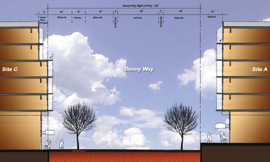
10 BROADWAY & DEY WAY 10th AVEUE At specific locations along Broadway, the Station Master Use Permit requires 22 foot wide sidewalks; City requirements on Broadway set an eighteen foot minimum. The predominant existing sidewalk width for Sites A, C and D along Broadway is 14 feet. To create a uniform and functional sidewalk width, the CDP provides for a retail façade setback of four feet, creating a uniform 18 foot width. Within this 18 foot zone is a five foot planting strip for landscaping and tree canopy, as well as space for intermittent bicycle parking. The openness of this space is a directly related to the height of the retail floor which subsequently determines the height of the residential bay windows, balconies and other elements in the four foot structural overhang of the upper floors. This approach, with a first floor height at approximately 20 foot, provides a 17 foot vertical clear zone that is open and spacious, enhancing the retail façade and the streetscape. In addition to weather protection offered by the retail setback and the residential bay and balcony overhangs, canopies, awnings, or other devices shall extend six to eight feet over the public right of way and constructed between 12 and 20 feet above the sidewalk. The same dimensional treatment occurs on the Denny facades of Sites A and C; however, Site A requires a plinth for the building to accommodate the slope of the site, providing space for a private plaza on the building s south facade, and a publicly accessible walkway on the east facade. 10th Avenue is a residential street with an intentionally different character than Broadway. Sites B, bookended by East John and East Denny, have planting strips within the 66 foot public right of way. By using a pooled Green Factor approach, this Plan s streetscape concept augments the planting strip by locating private gardens and courts in the eight foot setback from the property line. Setting the building façade back from the property line allows larger trees to be provided on this blockface of 10th Avenue, providing a unifying visual theme with the mature vegetation of Cal Anderson Park where 10th intersects Denny. The current curb to curb dimension on 10th Avenue is 23 feet, sufficient for two lanes of traffic, but not for parking. This street treatment provides for two 11 foot lanes (which could be reduced to 10 foot) and a seven foot zone for street parking. The use of curb bulbs will reduce the impact of street parking while providing a generous planting bed for the larger trees. In the portion of 10th Avenue accommodating street parking, the planting bed is seven feet wide, which allows for a smaller tree variety providing for variations in species, color, size and flowering. The sidewalk is six feet in width. This design approach to 10th Avenue contributes a greenscape for the eastern edge of Site B in a manner that enhances the building site, the neighborhood street, and the visual connection with the Park, and will set the standard for the subsequent redevelopment across the street. The pooled Green Factor score of.302 is achieved by these design solutions. Street Treatments 6

11 AMEITY AREA COORDIATED APPROACH The multiple purposes of the central plaza, pass-throughs, and agle Place Extension are achieved by a coordinated or pooled approach to the City s Amenity Area requirement. Given that the main station block provides comparatively greater opportunities for robust public use and civic engagement, this Plan s approach compensates for the limitations of Sites C and D, to the south and west of the main station block. Private Amenity Areas, also Cityrequired, will be accomplished by exterior building façade modulation and internal spaces provided by the developers of each site. DEY WAY FAÇADE SETBACK & PLITH Site A, abutting the Denny Way Festival Street, creates the opportunity for a 12 foot private plaza, set back from the building façade. This terrace area is achieved by using a plinth as the building s foundation to meet the public sidewalk as it falls three feet from west to east. By adding an adjoining 4 first floor retail setback, this space can be generously scaled for outdoor activities associated with the retail frontage, overlooking the festival street. FIRST FLOOR COURTS & STOOPS On Sites B-orth and South, the residential nature of the first floors provide the opportunity for ground floor entrances from agle Place Extension. UPPER FLOOR BALCOY/BAY ZOE Along Broadway and Denny Way on Site A, structural overhangs of four feet provide usable residential space above the ground floor while contributing to façade modulation and creating a weather-protected walking experience adjacent the retail storefronts. This zone can also provide a location for residential balconies, giving scale to the building façade and creating the opportunity for eyes on the street. STATIO ETRACE FAÇADE SETBACK At the north end of Site A (the corner of East John and Broadway) a ground floor diagonal building setback creates an open triangular space as sidewalk, emphasizing the station entrance, improving pedestrian sightlines to the orth Station Entrance, and creating a strong retail presence at this corner. RETAIL FAÇADE SETBACK This Plan s four foot setback from the property lines of Sites A, C and D, creates an 18 foot sidewalk width. This zone should be largely open, with cantilevered structural overhangs, while columns in this zone should be discouraged. This will provide maximum retail façade transparency, while leaving a generous sidewalk area that can accommodate curbside plantings and bike parking. On the west facade of Sites B-orth and B-South (along PE), stoops are allowed at the developers discretion, and Site B north may include live-work units, provided they do not include retail uses. Along the 10th Avenue East facade of the Sites B-orth and B-South, developers are required to provide stoop entrances to the residential units. At both building entry facades, a setback (10 from the sidewalk along PE and eight foot from the property line along 10th) provides space for entries, a private courtyard and private gardens. Along 10th, these private courts and gardens can be augmented by a three foot landscaped planting strip between the property line and the six foot public sidewalk, as a result of the pooled Green Factor. AMEITY AREAS SITE At Grade Amenity Area Balcony Area Roof Top Amenity Area Site A 16,527 s.f. 3,700 s.f. 17,000 s.f. Site B 8,485 s.f. 6,857 s.f. 0 s.f. Site C s.f. 2,500 s.f. 0 s.f. Site D 0 s.f. 1,020 s.f. 0 s.f. TOTAL 26,036 s.f. 14,077 s.f. 17,000 s.f. TOTAL, ALL AMEITY AREAS: 57,113 s.f. Amenity Areas 7


12 PLAZA / FARMERS MARKET A privately-owned, publicly-accessible plaza will occupy the southeastern corner of Site A, adjacent to the Denny Way Festival Street and the agle Place Extension (PE). Public use of the plaza and PE will be determined by the Site A property owner. As buildings on Sites A and B will include residential units fronting the plaza and PE, their use will need to respect the quiet enjoyment of the tenants. Besides public bicycle parking along its edge and as an active gathering area providing a place making element, the plaza and PE potentially could be used by the Broadway Farmers Market. Sound Transit may encumber the property for that purpose and require installation of appropriate utilities to support the Market and other activities. The plaza, at approximately 7,000 square feet, could with the temporary closing of PE, provide the space for approximately 50 farmers market stall tents. Additional farmers market stalls could occupy the Denny Festival Street under a City street use permit. On days when the plaza and/or PE are in active use, the owner of Site A will provide traffic control and limit use of the southern end of the private street. The plaza design and materials will be compatible with the designs of agle Place Extension and the Denny Way Festival Street so as to create a uniform style and functionality of private and public spaces. The plaza will be a unifying link between Broadway and 10th Avenue East, given the east-west pedestrian passthroughs. The plaza is also expected to provide a strong visual connection to Cal Anderson Park, as suggested in the Urban Design Framework. Plaza / Farmers Market 8


13 BICYCLE PARKIG The plaza environment provides an excellent opportunity for bicycle parking and storage, and the property transaction for Site A will ensure that provisions are made for that purpose. Accommodating bicycles will ensure that the plaza is activated, while providing convenient and secure parking for transit-related bike commuting. A plaza-adjacent area along the eastern edge of the Site A plinth is available and will not interfere with plaza activities. Alternately, a bike station-like retail storefront use on Site A may be substituted if it provides parking in the same manner, supply, and convenience. That facility would provide the same 2017 and 2030 rack installation counts and same public accessibility for transit riders. Additional secure bike storage will be provided by Sound Transit in the space west of the Station Vent Shaft, immediately north of the plaza. This bike parking will be in addition to 36 stalls provided by Sound Transit at the West Station Entrance by the Station Master Use Permit. Parking use projections are based on Sound Transit s bicycle demand estimation method 4% of P.M. period 2030 ridership (= 120 spaces in 2017; 120 expansion capacity). Bicycle parking adjacent the plaza will be a mixture of covered secure cages (long-term parking) and covered or uncovered racks (short-term parking). Per City code, TOD site developers will provide bicycle parking for tenants and residents within their buildings. While the Seattle Department of Transportation is responsible for on-street bicycle parking or other bicycle parking strategies, the Coordinated Development Plan s Streetscape concept demonstrates the potential to accommodate up to 75 bikes on Broadway sidewalks at Sites A and C. BICYCLE PARKIG SUPPLY Total Installed Added Site A Plaza: Racks Cage Totals Plaza Bike Parking 9


14 PEDESTRIA PASSAGES & PLAZA PEDESTRIA PASS-THROUGHS As elements of the pooled Amenity Area approach, Sites A and B will have east-west enclosed pedestrian passages, connecting Broadway to the plaza, agle Place Extension, and 10th Avenue East. These passages are to be the full height of the ground floorto-floor dimensions (15-20 feet), of similar width (15-20 feet), located approximately on axis with the Vent Shaft to allow a break in Broadway street façade. The west facade break will have provide an architectural feature to emphasize the pass-through. The passages will have publicly accessibility, but will be managed as private space, subject to compatible building uses, such as residential lobby access. At the discretion of the Site A developer, the pass-through may be open to the sky. PEDESTRIA PLITH The southern building facade of Site A will be set back 12 feet from the property line, providing a generous private space on the plinth adjacent and above the Festival Street. This provides a level surface for retail/restaurant frontage, while connecting to the pedestrian link on the east facade of the building. PEDESTRIA WAY The pedestrian way along Site A s eastern facade provides a connection from the building pass-through to the plaza and Denny Way. Due to the grade change along Denny Way, this pedestrian way on the plinth requires stairs from the plinth to the sidewalk and street, a three-foot change in grade. Pedestrian Passages & Plaza 10
, rather than that of each individual parcel.")

15 Green Factor & Sustainable Design CITY GREE FACTOR requirement The CDP provides for a coordinated or pooled approach to meeting City of Seattle Green Factor requirements. This approach is based on the total square footage of all parcels (107,489 s.f.), rather than that of each individual parcel. This approach provides flexibility and certainty for each developer that by the pooled approach not every site has to satisfy Green Factor requirements. As a result, the sites best able to provide amenities based on lot coverage and unifying design and functional principles, do so. Concepts recommended in the Urban Design Framework informed this approach. The Green Factor Score Sheet ties to the locations and square footages of landscape elements that produce a score of 0.302, exceeding the City requirement of 0.3. Based on the Score Sheet, Site A is intended to have a green roof (Score C.2). However, alternative methods to achieve an equivalent score will be considered if a green roof creates a structural hardship. GREESCAPE GREE BUILDIG REQUIREMET While not a Green Factor requirement, developers will be required by Sound Transit to meet or exceed green building standards. Sound Transit TOD projects must meet at minimum the LEED Silver/Evergreen Standard equivalencies. Bonus points in the RFQ/P process will be considered for development projects proposing to exceed the minimum green building standards. SUSTAIABLE DESIG The recently released Capitol Hill Eco-District report outlines strategies and considerations any developer should evaluate in pursuing sustainable building practices, such as participating in the Seattle 2030 District and providing for district approaches to energy and water management. TREESCAPE Green Factor 11

16 PUBLIC BEEFIT & URBA DESIG FRAMEWORK VISIO PUBLIC BEEFIT Sound Transit TOD policy encourages the agency to demonstrate good transit-oriented design and land use mixes appropriate to their setting, transit mode, and market conditions. An approved Development Agreement would create appropriate regulations, to be further guided by encumbrances and design guidelines by way of this Coordinated Development Plan and City-adopted new community design guidelines that will apply to the TOD sites. In response to the above policy, the public benefits shown in the CDP are voluntary on Sound Transit s part. They exceed any public benefits provided by recent Broadway developments, and are not those typically required by City development regulations. The centerpiece of good transit-oriented design are those amenities that encourage place making and active spaces. Sites A and B, that could accommodate the popular and vibrant Broadway Farmers Market. As previously described, additional public benefits include bicycle parking in excess of code requirements, public access on and through private property, the place-making amenity of the main station block plaza and private plinth plaza adjacent Denny Festival Street. These enhancements, inspired by the UDF, are beyond those typically provided by new development projects. Superior public accessibility occurs east to west on the main station block, through the Site A and B-South buildings, along the eastern facade of Site A, and the full length of agle Place Extension, linking East John and Denny Way, and Broadway and 10th Avenue. The building pass-throughs, plaza and agle Place Extension, while private property, will be encumbered by Sound Transit for managed public use. Design and materials coordination will occur at the interface of agle Place Extension, the plaza and the Denny Way Festival Street. Public Benefit 12

17 URBA DESIG FRAMEWORK The Capitol Hill Light Rail Station TOD Sites Urban Design Framework (UDF) embodies a considerable community effort to create a vision for Sound Transit s future development sites. In response to that effort, this Coordinated Development Plan has endeavored to incorporate numerous design elements and suggestions to be implemented through the Development Agreement. Major subjects addressed in the UDF include: streetscape design, site plan hierarchy, the inclusion of affordable housing, lower than standard parking ratios, inclusion of community and commercial space, increased density, sustainable development practices and improvements for both bicycle and pedestrian access. Specific recommendations also address the creation of a festival street on Denny, limited auto access to the main station site, widened sidewalks on Broadway, and the creation of a private woonerf-type street, agle Place Extension. The UDF calls for a site plan hierarchy that includes: a mid-block pass through from Broadway to 10th Avenue East, a large central plaza intended to house the Broadway Farmers Market, commercial space at the ground floor on Broadway, and possible inclusion of stoops and gardens at the ground level on 10th Avenue East. Sound Transit s CDP includes provisions for all of the elements. The UDF recognizes the importance of traffic circulation in the neighborhood and to the sites, calling for limits to auto access, reduced parking ratios, and no cut-through traffic on agle Place Extension, among other suggestions. on-motorized access is strongly advocated; the importance of plaza access, bicycle parking, and the pass-throughs are reflected in this Plan. The aforementioned coordinated approach for sustainable development practices is evidenced in the green roof and plantings, and LEED building requirements. The UDF calls for increased density on the site, recognizing the construction industry s five over one building type. This CDP, based on conventional market assumptions, anticipates a density equivalent of approximately 180 units per acre, within the limits of the allowed height and floor area ratios. This Plan balances and achieves many of the UDF s recommended features. Urban Design Framework 13

18 VEHICULAR CIRCULATIO PLA This Plan provides a coordinated approach to vehicular traffic circulation, ensuring adequate site access and egress for vehicles, while minimizing conflicts with other modes of travel. This is important in the dense urban neighborhood setting of the Capitol Hill Station where there will be a combined substantial increase in transit service (regional light rail and local street car), and in the context of the needs of existing vehicular traffic. Compared with the former built environment, the new development will create greater demands on the existing street system and its functionality due to a substantial increase in density. Also affecting this neighborhood circulation will be the East Denny Way Festival Street, altering use as an east-west neighborhood connection. The addition of the street car on Broadway, with curb parking eliminated will be major changes. The additional residential tenants and vehicles associated with redevelopment, along with the City s streetscape changes to Broadway, will occur in an environment changed by years of light rail and street car construction. Even with these changes, Sound Transit s 2011 traffic analysis for the TOD sites and immediate neighborhood indicated no significant impact based on the planned development. ew travel circumstances and patterns will occur with the completion of the station, the subsequent development, and new transit service. The coordinated vehicular circulation plan provides for these changes, while protecting the integrity of the neighborhood and enhancing the amenity-creating elements of the new development, including the main station block plaza, agle Place Extension (PE), and the Denny Festival Street. The circulation plan, worked out through negotiations leading to the Development Agreement, indicates how the traffic patterns in the vicinity of the sites will function. Ensuring accessibility to PE is fundamental to the success of the new main station block development and in reducing impacts on the neighborhood. PE is necessary for Site A and B resident access and service requirements including Sound Transit Facilities service parking (see hatched area), as well as for the potential of the farmers market and other plaza uses. PE will not function as a cut-through street between Denny and John Street. Sound Transit will retain access to its facilities for planned and emergency maintenance via the plaza and PE. As allowed by the approved station MUP, agency parking will be provided adjacent the eastern wall of the orth headhouse (hatched area). Implementing the coordinated circulation plan ensures neighborhood vehicular accessibility that contributes to an overall sense of place, functionality and development continuity. Vehicular Access 14

19 VEHICULAR GARAGE ACCESS Vehicular garage access is a fundamental development right for each site, central to their functional and financial success. At each site, a below-grade parking option must be provided to respond to the market and service requirements, such as garbage removal. The access points, as negotiated with Seattle Department of Transportation, are shown with colored arrows. In concert with the coordinated circulation plan, vehicular garage access must address site constraints based on the location of transit facilities, limited points of site access, the economics of underground parking, the surrounding street grid, and the individual and combined uses of the Denny Festival Street and the agle Place Extension. Site A parking garage access is from agle Place Extension (PE), adjacent to the site s retail and service loading dock. Access and egress will be to and from agle Place, Denny Way, and East John Street. For days and times the plaza or festival street is in use, vehicular traffic on the south end of PE will be restricted by the property owner. orth end access for Sites A, B-orth and South will occur on PE. Sites B parking access is required to be off 10th Avenue East because it is more efficient, costs less than access off agle Place Extension, and avoids vehicular conflicts with PE pedestrians, bicyclists, plaza activities, and with Site A service delivery requirements. Site C s required curb cut has only one feasible location, access from agle Place. Similarly, Site D is constrained to a single curb cut location on Broadway that will be fronted with the First Hill Street Car Station track, potentially creating a temporary blocking of the curb cut due to transit operations. That conflict will be resolved when the street car expands northward on Broadway. Garage Access 15
20 GARAGE PLAS Explicit garage plans have been prepared to understand the feasibility, constraints, and potential capacity for each site. The parking space counts in the below table are a conservative indication of how the market might respond, as opposed to any required minimum or maximum. Underground parking will be a considerable expense to developers. However, the City has no minimum parking requirement. There is the potential for developer to work together to create a pooled approach to site parking, as no one site can exceed a residential ratio of.7 stalls per unit. In addition, there is the requirement that parking stalls be unbundled from all affordable housing unit rents. Site A, with its Broadway retail frontage, has the greatest potential need for commercially-related parking. However, the site is constrained somewhat by an inefficient shape for underground parking floors, as well as access off PE. Sites B-orth and B-South will share a parking garage entrance off a 10th Avenue curb cut splitting the property boundary. Each developer will determine the parking required, within the overall average of.7 stalls per residential unit. This concession to a single curb cut creates the potential that the Site B owners may cooperate to find the most efficient and cost-effective way to build, and perhaps share, parking. Sites C and D have below grade constraints making a.7 ratio unlikely. Sound Transit s preferred TOD ratio of.7 spaces per residential unit was not a factor in the market rate feasibility analysis. It is possible that site constraints and cost will reduce the preferred ratio. The requirement to unbundle parking cost from affordable unit rents may further reduce residential parking availability. Sound Transit will encumber all the TOD parcels to prevent on-site parking being used for transit park and ride purposes, or multi-hour commercial parking. SITE CAPACITY (Based on Feasibility Analysis) TOD SCEARIO (Based on 0.7 Residential Ratio Site Flr 1 Flr 2 Flr 3 Total Res. units Retail Res. Ratio TOD Ratio Res Excess/Gap (1) Spaces Available (2) A :1 ` B orth (3) - 1: B South : C D Total (1) Excess/Gap = Total Capacity - Residential Garage Plans 16
21 GARAGE PLAS Garage Plans 17
Future Proposed Development
 Future Proposed Development on and around Link light rail s Capitol Hill Station Meeting September 24, 2012 Tonight s Agenda 6:00 pm Open House 6:30 pm Introductions Richard Conlin, City of Seattle Councilmember/Sound
Policies and Code Intent Sections Related to Town Center
 Policies and Code Intent Sections Related to Town Center The Town Center Vision is scattered throughout the Comprehensive Plan, development code and the 1994 Town Center Plan. What follows are sections
Clairtrell Area Context Plan
 Clairtrell Area Context Plan March 2005 Urban Development Services City Planning Contents 1. Introduction... 4 2. Development Structure... 6 2.1 Streets... 7 2.1.1 Sheppard Avenue and Bayview Avenue...
Town Center (part of the Comprehensive Plan)
") Town Center (part of the Comprehensive Plan) Mercer Island Town Center Looking North (2014) In 1994, a year-long process culminated in a set of design guidelines and code requirements for the Town Center
Town Center (part of the Comprehensive Plan) Mercer Island Town Center Looking North (2014) In 1994, a year-long process culminated in a set of design guidelines and code requirements for the Town Center
WEST LOOP DESIGN GUIDELINES CHECKLIST
 WEST LOOP DESIGN GUIDELINES CHECKLIST Section 1.0 General Strategies 1.1 DESIGN EXCELLENCE: ENCOURAGE HIGH QUALITY AND INNOVATIVE DESIGN OF NEW BUILDINGS WITHIN THE WEST LOOP WITHOUT BEING PRESCRIPTIVE
The transportation system in a community is an
 7 TRANSPORTATION The transportation system in a community is an important factor contributing to the quality of life of the residents. Without a sound transportation system to bring both goods and patrons
EXISTING COMPREHENSIVE PLAN
 EXISTING COMPREHENSIVE PLAN Town Center Land Use Element: V. LAND USE POLICIES Town Center Mercer Island's business district vision as described in "Your Mercer Island Citizen-Designed Downtown" was an
VILLAGE OF SKOKIE Design Guidelines for Mixed-Use Districts NX Neighborhood Mixed-Use TX Transit Mixed-Use CX Core Mixed-Use
 VILLAGE OF SKOKIE Design Guidelines for Mixed-Use Districts NX Neighborhood Mixed-Use TX Transit Mixed-Use CX Core Mixed-Use TABLE OF CONTENTS CHAPTER 1 SITE DESIGN Purpose 1 CHAPTER 2 SITE DESIGN Streetscape
Buildings may be set back to create small plazas provided that these setbacks do not substantially disrupt the street wall s continuity.
 6-22 Community Design Street Walls and Street-front Setbacks The siting of buildings will play a critical role in establishing the character and sense of place for the District. Siting buildings at the
The University District envisions, in its neighborhood
 Envisioning the University District Link Light Rail in Seattle s neighborhoods CIY OF SEALE CONCEP-LEVEL SAION AREA PLANNING RECOMMENDAION RESOLUION # 30165 EXHIBI L Vision 08.2000 he University District
3.0 URBAN DESIGN. December 6, OVERVIEW
 Urban Design 3.0 URBAN DESIGN December 6, 2007 3.1 OVERVIEW The highly urban character of Easton Place is defined by the overall design of the community. The following sections provide an overview of the
Highland Village Green Design Guidelines
 Highland Village Green Design Guidelines Publishing Information Title Highland Village Green Design Guidelins Author The City of Calgary Status DRAFT - Proposed document subject to changes Additional Copies
5.1 Site Plan Guidelines
 5. Community Core Guidelines Development of the Community Core will take place by plan of subdivision and site plan approval. It will occur in a phased manner that will reflect the timing of residential
DRAFT. 10% Common Open Space
 % OF CHARLOTTE IS CATEGORIZED AS A. LAND USES : Placeholder map displaying location of Place Type GOALS: Accommodate XX% of future growth. Provide a concentration of primarily commercial and civic activity
Silverdale Regional Center
 Silverdale Regional Center Vision for Silverdale Regional Center The Silverdale Regional Center Plan (Plan) will guide the evolution of the Silverdale Regional Center from a collection of strip malls and
FREEWAY/TOURIST DISTRICT
 FREEWAY/TOURIST DISTRICT DESIGN STANDARDS FOR THE CITY OF MOUNTLAKE TERRACE March, 2014 MOUNTLAKE TERRACE FREEWAY/TOURIST DESIGN STANDARDS March, 2014 1 TABLE OF CONTENTS Introduction...1 Design Site Design
MIXED-USE VILLAGE OVERLAY FLOATING DISTRICT
 MIXED-USE VILLAGE OVERLAY FLOATING DISTRICT Zoning regulations developed by committee to the Planning Board for the Town of DeWitt, NY Issue date: 13 July 2017 revised 3/12/2018, revised 4/26/2018, 5/9/2018
FRUITVALE TRANSIT VILLAGE (Phase 2) Residential Project
 Residential Project") FRUITVALE TRANSIT VILLAGE (Phase 2) Residential Project DEVELOPER: SIGNATURE PROPERTIES ARCHITECT: HKIT ARCHITECTS April 23, 2010 TABLE OF CONTENTS 3 Vision 4 Description of Site 5 Guiding Concepts 6
FRUITVALE TRANSIT VILLAGE (Phase 2) Residential Project DEVELOPER: SIGNATURE PROPERTIES ARCHITECT: HKIT ARCHITECTS April 23, 2010 TABLE OF CONTENTS 3 Vision 4 Description of Site 5 Guiding Concepts 6
SDOT DPD. SDOT Director s Rule DPD Director s Rule DCLU DR SED DR of 7 CITY OF SEATTLE
 SDOT SDOT Director s Rule 2-07 DPD Applicant: CITY OF SEATTLE Page 1 of 7 Supersedes: DCLU DR 11-93 SED DR 93-4 Seattle Department of Transportation (SDOT) Department of Planning and Development (DPD)
CHAPTER 3. Design Standards for Business, Commercial, Industrial, Recreational and Institutional Uses
 CHAPTER 3 Design Standards for Business, Commercial, Section Number Title Ordinance Number Date of Ordinance 16-3-1 Applicability 2006-11 2008-04 07-01-08 16-3-2 Uniform Standards for Architectural Design
REQUEST Current Zoning: O-15(CD) (office) Proposed Zoning: TOD-M(CD) (transit oriented development mixed-use, conditional)
 (office) Proposed Zoning: TOD-M(CD) (transit oriented development mixed-use, conditional)") Rezoning Petition 2016-117 Zoning Committee Recommendation January 4, 2017 REQUEST Current Zoning: O-15(CD) (office) Proposed Zoning: TOD-M(CD) (transit oriented development mixed-use, conditional) LOCATION
Rezoning Petition 2016-117 Zoning Committee Recommendation January 4, 2017 REQUEST Current Zoning: O-15(CD) (office) Proposed Zoning: TOD-M(CD) (transit oriented development mixed-use, conditional) LOCATION
(DC1) Direct Development Control Provision DC1 Area 4
 Direct Development Control Provision DC1 Area 4") . General Purpose (DC) Direct Development Control Provision DC Area 4 The purpose of this Provision is to provide for an area of commercial office employment and residential development in support of the
. General Purpose (DC) Direct Development Control Provision DC Area 4 The purpose of this Provision is to provide for an area of commercial office employment and residential development in support of the
Uptown Rideau Street Secondary Plan [Amendment #166, January 12, 2016]
![Uptown Rideau Street Secondary Plan [Amendment #166, January 12, 2016]](/thumbs/76/73760497.jpg "Uptown Rideau Street Secondary Plan [Amendment #166, January 12, 2016]") [Amendment #166, January 12, 2016] The policies of this Secondary Plan are in effect, save and except for the property at 560 Rideau Street, for which there remains a site specific appeal to this Secondary
[Amendment #166, January 12, 2016] The policies of this Secondary Plan are in effect, save and except for the property at 560 Rideau Street, for which there remains a site specific appeal to this Secondary
Chapter PEDESTRIAN COMMERCIAL (PC) ZONING DISTRICT
 ZONING DISTRICT") Chapter 11-17 PEDESTRIAN COMMERCIAL (PC) ZONING DISTRICT Sections: 11-17-01 GENERAL PURPOSE 11-17-02 PERMITTED BUILDING TYPES 11-17-03 USES PERMITTED WITH DESIGN REVIEW 11-17-04 USES PERMITTED BY CONDITIONAL
Chapter 11-17 PEDESTRIAN COMMERCIAL (PC) ZONING DISTRICT Sections: 11-17-01 GENERAL PURPOSE 11-17-02 PERMITTED BUILDING TYPES 11-17-03 USES PERMITTED WITH DESIGN REVIEW 11-17-04 USES PERMITTED BY CONDITIONAL
appendix and street interface guidelines
 appendix five: building and street interface guidelines appendix 5 building and street interface guidelines BOULEVARDS Boulevards are generally characterized by higher levels of traffic movement at higher
Gold Line Bus Rapid Transit Transit Oriented Development (BRTOD) Helmo Station Area Plan
 Helmo Station Area Plan") Appendix F Gold Line Bus Rapid Transit Transit Oriented Development (BRTOD) Helmo Station Area Plan Introduction and Purpose of the Plan The Gold Line Bus Rapid Transit facility is an eleven-mile dedicated
Appendix F Gold Line Bus Rapid Transit Transit Oriented Development (BRTOD) Helmo Station Area Plan Introduction and Purpose of the Plan The Gold Line Bus Rapid Transit facility is an eleven-mile dedicated
13 THORNHILL YONGE STREET STUDY IMPLEMENTATION CITY OF VAUGHAN OPA 669 AND TOWN OF MARKHAM OPA 154
 13 THORNHILL YONGE STREET STUDY IMPLEMENTATION CITY OF VAUGHAN OPA 669 AND TOWN OF MARKHAM OPA 154 The Planning and Economic Development Committee recommends the adoption of the recommendations contained
B. Blocks, Buildings and Street Networks
 B. Blocks, Buildings and Street Networks Figure IV.4 A rational block pattern with connected streets Introduction The single most important element in the physical and functional integration of mixed use
The Village. Chapter 3. Mixed Use Development Plan SPECIFIC PLAN
 The Village SPECIFIC PLAN Chapter 3 3.1 INTRODUCTION 3.1.1 Purpose This Chapter describes the development regulations applicable to the Mixed-Use and Transit Center Planning Areas. These form-based regulations
Developer s Program. The Station at East 54
 Developer s Program The Station at East 54 Existing Conditions The Station at East 54 is proposed for a 1.12 acre site at the northeast corner of Hamilton Road and Prestwick Road, tucked between the East
SUBCHAPTER 4-B GUIDELINES FOR THE B-3 COMMERCIAL CHARACTER AREA
 1 SUBCHAPTER 4-B GUIDELINES FOR THE B-3 COMMERCIAL CHARACTER AREA Downtown Bozeman should be the location of buildings of greatest height and intensity in the community. The following guidelines apply
URBAN DESIGN BRIEF URBAN DESIGN BRIEF 721 FRANKLIN BLVD, CAMBRIDGE August 2018
 URBAN DESIGN BRIEF URBAN DESIGN BRIEF 721 FRANKLIN BLVD, CAMBRIDGE August 2018 DESIGN BRIEF CONTENTS PART A 1.0 INTRODUCTION 2.0 DESCRIPTION & ANALYSIS OF SITE CONTEXT 3.0 DESIGN CONSTRAINTS AND OPPORTUNITIES
PUBLIC RIGHT-OF-WAY IN THIS CHAPTER PUBLIC REALM
 PUBLIC RIGHT-OF-WAY This section provides design guidelines for improvements in the public right-of-way. The public right-of-way refers to streets, sidewalks, non-vehicular thoroughfares, parks and greenways
This Review Is Divided Into Two Phases:
 Semiahmoo Town Centre Review The purpose of this review: To review the Semiahmoo Town Centre Concept Plan, originally approved in 1993, to ensure that this centre will continue to serve the needs of South
Design Guidelines. Roosevelt. Mike Podowski DPD Design Guidelines Ordinance ATT 13 August 13, 2012 Version #1
 Roosevelt Design Guidelines The Roosevelt Neighborhood Design Guidelines apply within the Neighborhood Boundary. Map 1 2 Map 2 3 Map 3 4 CS1 Natural Systems and Site Features Citywide Guideline: Use natural
Tyvola & Archdale Transit Station Area Plan. June 5, 2008
 Tyvola & Archdale Transit Station Area Plan Second Public Meeting June 5, 2008 Presentation Outline 1. Purpose and Process 2. Station Area Overview 3. Plan Recommendations 4. Comments Received and Proposed
Wide asphalt driveway abutting school property. garage built with incompatible materials, too close to park. incompatible fencing materials
 Wide asphalt driveway abutting school property incompatible fencing materials garage built with incompatible materials, too close to park Lack of plantings as a buffer between private property and open
Future Five. Design/ Development Guidelines. January 2008 Amended June 08 per City Council motion
 Future Five Design/ Development Guidelines January 2008 Amended June 08 per City Council motion 5-Points Design Guidelines Table of Contents I. Introduction 3 II. Area boundaries 4 III. Review Process
4.1.3 LAND USE CATEGORIES
 4.1.3 LAND USE CATEGORIES a. City Center District The City Center District incorporates the existing character and mix of uses in downtown Belmont to encourage redevelopment and new development in keeping
Incentive Zoning Regulations Florida Municipal City of Orlando
 Topic: Resource Type: State: Jurisdiction Type: Municipality: Year (adopted, written, etc.): 2002 Community Type applicable to: Title: Incentive Zoning Regulations Florida Municipal City of Orlando Document
SECTION TWO: Overall Design Guidelines
 SECTION TWO: Overall Design Guidelines This section provides overall design principles and guidelines for the Gardnerville Mixed-use Overlay. They provide criteria for mixed-use places consisting of residential,
CAPITOL HILL Light Rail Station Sites Urban Design Framework DRAFT. May 9, 2011
 CAPITOL HILL Light Rail Station Sites Urban Design Framework DRAFT May 9, 2011 EXECUTIVE SUMMARY Though a series of engaging workshops, meetings and conversations and the advocacy of many community leaders,
CENTERS AND CORRIDORS
 INITIAL DESIGN STANDARDS AND GUIDELINES for CENTERS AND CORRIDORS City of Spokane Planning Services Third Floor, City Hall 808 W. Spokane Falls Blvd. Spokane, WA 99201-3329 (509) 625-6300 www.spokaneplanning.org
Appendix C: Interim Mixed-Use Evaluation Criteria
 Appendix C: Interim Mixed-Use Evaluation Criteria C-1 Appendix C: Interim Mixed-Use Evaluation Criteria PURPOSE: The implementation of numerous policies contained within the Master Plan hinges on the creation
Urban Design Manual PLANNING AROUND RAPID TRANSIT STATIONS (PARTS) Introduction. Station Study Areas
 Introduction. Station Study Areas") 111111 PLANNING AROUND RAPID TRANSIT STATIONS (PARTS) Introduction The ION rapid transit system will link Waterloo, Kitchener and Cambridge through a central transit corridor (CTC). There are a number
111111 PLANNING AROUND RAPID TRANSIT STATIONS (PARTS) Introduction The ION rapid transit system will link Waterloo, Kitchener and Cambridge through a central transit corridor (CTC). There are a number
MIDTOWN MIXED-USE VILLAGE. TECHNICAL DATA SHEET COMPONENT C-1 FOR PUBLIC HEARING - PETITION NUMBER Project No RZ1.1. Issued.
 N MIDTOWN MIXED-USE VILLAGE TECHNICAL DATA SHEET COMPONENT C- FOR PUBLIC HEARING - PETITION NUMBER 04-00 Project No. 496 Issued Revised SCALE: " = 0' N 0 0 0 40 RZ. c GENERAL PROVISIONS: a. SITE LOCATION.
B L A C K D I A M O N D D E S I G N G U I D E L I N E S for Multi-family Development
 B L A C K D I A M O N D D E S I G N G U I D E L I N E S for Multi-family Development Adopted June 18, 2009 This section of the Design and focuses on site planning and design guidance for new multi-family
5.7 Design Criteria for the Private Realm Organization of Private Realm Design Standards and Guidelines Guidelines vs.
 5.7 Design Criteria for the Private Realm The Private Realm (shown in Exhibit 5.7a) includes the privately owned property not included in the Setback Realm described in the previous section. It encompasses
Figure 3-1: Public Realm Plan
 3 Public Realm Figure 3-1: Public Realm Plan 3.1 Public Realm Concept The public realm concept for the Little Mountain site integrates a clear and accessible movement network with public spaces for social
EXHIBIT A. Tax Increment Reinvestment Zone No. 1 (Town Center) First Amended Project Plan 1
 First Amended Project Plan 1") EXHIBIT A Tax Increment Reinvestment Zone No. 1 (Town Center) First Amended Project Plan 1 1 As amended by Resolution No. 2008-02-001(TR1R) of the Tax Increment Reinvestment Zone No.1, and approved to
EXHIBIT A Tax Increment Reinvestment Zone No. 1 (Town Center) First Amended Project Plan 1 1 As amended by Resolution No. 2008-02-001(TR1R) of the Tax Increment Reinvestment Zone No.1, and approved to
Millbrae TOD #2 Project Analysis
 Millbrae TOD #2 Project Analysis Project Description A Site Development Permit and Conditional Use Permit are proposed to allow for a mixed-use transitoriented development on approximately 9 Acres located
PLAN ELEMENTS WORKSHOP. April 5, 2016
 PLAN ELEMENTS WORKSHOP April 5, 2016 needs more housing. But there is no one-size fits-all solution. Every neighborhood has its own character. In some places, density is not only appropriate it is badly
MIXED-USE ZONING DISTRICT DESIGN GUIDELINES
 MIXED-USE ZONING DISTRICT DESIGN GUIDELINES In addition to the development regulations contained in the Mixed-Use Zoning District, design guidelines are presented here to provide an added level of definition
TRANSIT-ORIENTED DEVELOPMENT POLICY DRAFT. City Planning and Development Department Kansas City, Missouri
 TRANSIT-ORIENTED DEVELOPMENT POLICY DRAFT City Planning and Development Department Kansas City, Missouri What is Transit Oriented Development (TOD)? Development that focuses land uses around a transit
Town of Portola Valley General Plan. Nathhorst Triangle Area Plan
 Town of Portola Valley General Plan Amended December 10, 1997 Table of Contents Introduction... 1 Planning Area... 1 Objectives... 2 Principles... 2 Standards... 4 Description... 4 Community Commercial...
DRAFT. October Wheaton. Design Guidelines
 October 2011 DRAFT Wheaton Design Guidelines 2 Draft - Design Guidelines - Wheaton Sector Plan Contents 04 Section 1: Introduction 06 Section 2: Context 08 Section 3: Design Guidelines 09 Goal 1: Create
TABLE OF CONTENTS 1.0 INTRODUCTION... 3
 TABLE OF CONTENTS 1.0 INTRODUCTION... 3 1.1. BACKGROUND... 3 1.2. THE PROPOSAL... 5 2.0 EXISTING POLICY FRAMEWORK... 5 2.1. PROVINCIAL POLICY STATEMENT (PPS)... 5 2.2. CITY OF LONDON OFFICIAL PLAN (OP)...
ALBEMARLE COUNTY CODE CHAPTER 18 ZONING SECTION 20A NEIGHBORHOOD MODEL - NMD
 CHAPTER 18 ZONING SECTION 20A NEIGHBORHOOD MODEL - NMD Sections: 20A.1 PURPOSE AND INTENT 20A.2 STATUS AS A PLANNED DEVELOPMENT DISTRICT 20A.5 CODES OF DEVELOPMENT 20A.6 PERMITTED USES 20A.7 RESIDENTIAL
Transit Station Area Development Guidelines
 Transit Station Area Development Guidelines Adopted June 2017 Transit Station Area Development Guidelines Table of Contents Development Around Transit Stations Using the Guidelines Thresholds and Procedures
A. WHAT IS A GENERAL PLAN?
 I. Introduction A. WHAT IS A GENERAL PLAN? A general plan is the planning guideline for the future of a city. It contains goals and policies which regulate urban development, the protection of the natural
OPPORTUNITY SITES. A. Introduction. Chapter 5
 OPPORTUNITY SITES A. Introduction As described in Chapter 2, the land use framework establishes an organizing structure for where and how growth within the plan area will occur. The land use framework
Bloor St. W. Rezoning - Preliminary Report
 STAFF REPORT ACTION REQUIRED 1638-1644 Bloor St. W. Rezoning - Preliminary Report Date: April 1, 2008 To: From: Wards: Reference Number: Toronto and East York Community Council Acting Director, Community
lot flankage Y street 16m 6m landscape strip for large site 3m landscape strip for small medium site
 Commercial General Commercial Objectives Create developments compatible with adjacent land uses in scale, function and character Define a consistent and attractive street edge with quality landscaping,
TO: FROM: SUBJECT: Background
 TO: FROM: SUBJECT: Long Range Planning Committee and Zoning Committee of the Planning Commission Kellie Brown and Margaret Rhodes, Planning Division, CPHD DATE: June 8, 2017 Courthouse Square Implementation
CHAPTER 12 IMPLEMENTATION
 CHAPTER 12 IMPLEMENTATION The 2010 Town of Denton Comprehensive Plan is intended to capture a vision of the future of Denton. As such, it provides a basis for a wide variety of public and private actions
REZONING GUIDE. Zone Map Amendment (Rezoning) - Application. Rezoning Application Page 1 of 3. Return completed form to
 - Application. Rezoning Application Page 1 of 3. Return completed form to") Zone Map Amendment (Rezoning) - Application COMMUNITY PLANNING & DEVELOPMENT REZONING GUIDE Rezoning Application Page 1 of 3 PROPERTY OWNER INFORMATION* CHECK IF POINT OF CONTACT FOR APPLICATION Property
Zone Map Amendment (Rezoning) - Application COMMUNITY PLANNING & DEVELOPMENT REZONING GUIDE Rezoning Application Page 1 of 3 PROPERTY OWNER INFORMATION* CHECK IF POINT OF CONTACT FOR APPLICATION Property
Gateway commercial MIXED USE MASTER SITE PLAN. CITILAND AIrDRIE GATEWAY VENTURE INC. airdrie GATEWAY COMMERCE CENTRE. airdrie, ALBERTA FEBRUARY 2012
 Gateway commercial MIXED USE MASTER SITE PLAN 1914 CENTRE STREET NORTH CALGARY, AB CANADA T2E 2S8 T. 403.264.7177 F. 403.264-7175 WWW.CITILAND.CA CITILAND AIrDRIE GATEWAY VENTURE INC. airdrie GATEWAY COMMERCE
40 Years of Smart Growth Arlington County s Experience with Transit Oriented Development in the Rosslyn-Ballston Metro Corridor
 40 Years of Smart Growth Arlington County s Experience with Transit Oriented Development in the Rosslyn-Ballston Metro Corridor A presentation by the Arlington County Department of Community Planning,
CITY OF MERCER ISLAND DESIGN COMMISSION STAFF REPORT
 CITY OF MERCER ISLAND DESIGN COMMISSION STAFF REPORT Agenda Item: 2 March 9, 2011 Project: Description: Applicant: DSR11-004 The applicant is requesting approval to replace the existing exterior wood framed
40 Years of Smart Growth Arlington County s Experience with Transit Oriented Development in the Rosslyn-Ballston Metro Corridor
 40 Years of Smart Growth Arlington County s Experience with Transit Oriented Development in the Rosslyn-Ballston Metro Corridor A presentation by the Arlington County Department of Community Planning,
Pedestrian and Bike Bridge LOGO
 6.2.2 Pedestrian and Bike Bridge The proposed pedestrian and bike crossing re-envisions the existing bridge at Pismo Creek on Cypress Street. The bridge is currently underutilized by vehicular through
PROPOSED WATERFRONT DISTRICT DESIGN STANDARDS
 PROPOSED WATERFRONT DISTRICT DESIGN STANDARDS 20.25 DESIGN REVIEW. 20.25.080 WATERFRONT DISTRICT A. Purpose. This section is intended to implement The Waterfront District Subarea Plan by: 1. Creating a
GUIDING PRINCIPLES IN THIS CHAPTER
 GUIDING PRINCIPLES The guiding principles and design concepts in this chapter work together with the Chapel Hill 2020 Comprehensive Plan to support new public places that can be enjoyed by all while also
NEC of Central Avenue and Indian School Road
 NEC of Central Avenue and Indian School Road For this location, there are two applicable plans that provide guidance on development. The two plans include the Indian School Specific Plan (1991) and the
WINDSOR GLEN DESIGN GUIDELINES
 WINDSOR GLEN DESIGN GUIDELINES Adopted by Council, 2006 WINDSOR GLEN REDEVELOPMENT DESIGN GUIDELINES August 2006 1.0 Master Plan Organization For this area of the Coquitlam Town Centre, a mix of high,
North Downtown Specific Plan MEMORANDUM
 North Downtown Specific Plan MEMORANDUM MEETING DATE: November 13, 2017 TO: Members of the North Downtown Specific Plan Advisory Committee FROM: Jeanine Cavalli, Senior Planner SUBJECT: Materials for the
Official Community Plan Bylaw No. 4360, 2004, Amendment Bylaw No. 4897, 2016 (Sewell s Landing)
") District of West Vancouver Official Community Plan Bylaw No. 4360, 2004, Amendment Bylaw No. 4897, 2016 (Sewell s Landing) Effective Date: 1089612v1 District of West Vancouver Official Community Plan Bylaw
District of West Vancouver Official Community Plan Bylaw No. 4360, 2004, Amendment Bylaw No. 4897, 2016 (Sewell s Landing) Effective Date: 1089612v1 District of West Vancouver Official Community Plan Bylaw
KEIZER STATION PLAN INTRODUCTION
 KEIZER STATION PLAN INTRODUCTION Planning for this area began in 1987 when the Keizer Comprehensive Plan established the Chemawa Activity Center and McNary Activity Center. The first Chemawa Activity Center
V. Vision and Guiding Principles
 V. Vision and Guiding Principles The Master Plan for the Powers Ferry Corridor seeks a foundation in the desires of the community. At times, various elements of the community offered opposing viewpoints,
FUTURE LAND USE ELEMENT
 FUTURE LAND USE ELEMENT GOAL I: To create and sustain a great place to live, play, and prosper Objective 1: The City of Ocala shall incorporate the principles and strategies of the Ocala 2035 Vision into
Status Report: MD 355 Project
 Status Report: MD 355 Project OCTOBER 2006 M-NCPPC MONTGOMERY COUNTY PLANNING DEPARTMENT Summary of Community Comments, and break to the Results of the MD 355 Participation Session Brookside Gardens -
Walnut Creek Transit Village Design Guidelines. Part Three III - 25
 C. General Design Criteria Part Three DRAFT 0/6/ III - 5 Frontage Types Frontage is a semi-public transition zone at the ground level where public and private realms meet. An understanding of various frontage
DRAFT Northeast Quadrant of Kipling Avenue and Highway 7 DRAFT AUGUST 29, Goals Land Use. The goals of this Plan are to:
 AUGUST 29, 2017 12.15 Northeast Quadrant of Kipling Avenue and Highway 7 12.15.1 Goals 12.15.2 Land Use The goals of this Plan are to: 12.15.2.1 General Provisions: a) Ensure the development of a compact
4. INDUSTRIAL 53 CASTLE ROCK DESIGN
 4. INDUSTRIAL 53 CASTLE ROCK DESIGN CASTLE ROCK DESIGN 54 4. INDUSTRIAL Overview Well-designed and attractive industrial centers are the product of blending economic realities with both functional and
Baumgarten MPUD. Exhibit 3 Evaluation Criteria
 Pursuant to LDC subsections 10.02.13 B, 10.02.08 F and Chapter 3 G. of the Administrative Code, staff s analysis and recommendation to the Planning Commission, and the Planning Commission s recommendation
Planning Board Briefing
 Planning Board Briefing Why Now? The Sector Plan Implementation Chapter States: Before Stage 1 begins, the following must occur: Approval of the Sectional Map Amendment. Approval of the Greater Lyttonsville
HIGHLAND VILLAGE GREEN URBAN DESIGN PRINCIPLES/GUIDELINES
 URBAN DESIGN GUIDING PRINCIPLES/GUIDELINES CONTEXT/CHARACTER The City of Calgary s Municipal Development Plan (MDP), Transit-Oriented Development (TOD) Policy Guidelines and Main Street/Corridor policy
2.0 THE PLATINUM TRIANGLE VISION
 2.0 THE PLATINUM TRIANGLE VISION The envisions an exciting future for the area surrounding Angel Stadium of Anaheim, the Honda Center and The Grove of Anaheim. 2.1 Planning Principles In order to further
Resolution : Exhibit A. Downtown District Design Guidelines March 2003
 Resolution 03-011: Exhibit A Downtown District Design Guidelines March 2003 DOWNTOWN DISTRICT DESIGN GUIDELINES CITY OF SOUTHLAKE, TEXAS Adopted March 2003 1 DOWNTOWN DISTRICT DESIGN GUIDELINES Adopted
WATERFRONT DISTRICT DESIGN STANDARDS
 WATERFRONT DISTRICT DESIGN STANDARDS 20.25.080 WATERFRONT DISTRICT A. Purpose. This section is intended to implement The Waterfront District Subarea Plan by: 1. Creating a safe, vibrant mixed-use urban
CHAPTER 1. Ms. Guajardo s Class - Central Elementary CH 1 1
 INTRODUCTION CHAPTER 1 Ms. Guajardo s Class - Central Elementary CH 1 1 1.1 SETTING South Centre City is a linear corridor south of Downtown Escondido paralleling Centre City Parkway and South Escondido
City of Hermosa Beach Administrative Policy #
 City of Hermosa Beach Administrative Policy # SUBJECT: Living Streets Policy Date: Approved by: City Council Authority: Public Works Department & Community Development Department Mayor, PURPOSE The City
University of the District of Columbia Van Ness Campus Master Plan Community Open House 3. December 8, 2010
 University of the District of Columbia Van Ness Campus Master Plan Open House 3 December 8, 2010 Introductions Sequence of Work: Campus Master Plan BEGIN: INTRODUCE AND START WORK Project Initiation Team
Urban Design Manual 2.0 DRIVE-THROUGH FACILITIES. Background. Urban Design Challenges
 222221 2.0 DRIVE-THROUGH FACILITIES Background In recent years, drive-through facilities have grown significantly in popularity with drive-through restaurants, in particular, being established on numerous
CHAPTER 6: Community Design and Appearance
 AGLE AREA COMMUNITY Plan CHAPTER 6 CHAPTER 6: Community Design and Appearance Community Design and Appearance How a community is designed and what a community looks like are attributes fundamental to the
ELMVALE ACRES SHOPPING CENTRE MASTER PLAN
 ELMVALE ACRES SHOPPING CENTRE MASTER PLAN Contents 1.0 INTRODUCTION... 2 2.0 LOCATION... 2 3.0 EXISTING CONTEXT... 2 4.0 VISION & GUIDING PRINCIPLES... 2 5.0 LAND USE AND BUILT FORM... 4 5.1 St. Laurent
GUIDELINES. Transit Oriented Development. Approved by Edmonton City Council on February 15, 2012 in tandem with City Policy C565
 Transit Oriented Development GUIDELINES Prepared by the City of Edmonton Sustainable Development and Transportation Services Departments Approved by Edmonton City Council on February 15, 2012 in tandem
THE GREEN VISION WORKSHOP Friday, November 6, 2009
 THE GREEN VISION WORKSHOP Friday, November 6, 2009 SUSTAINABLE LONG RANGE PLANNING IN SANTA MONICA Eileen Fogarty Director, Planning and Community Development GREEN BUILDINGS Santa Monica has the most
Urban Design Brief to 1557 Gordon Street & 34 Lowes Road West
 Urban Design Brief 1533 to 1557 Gordon Street & 34 Lowes Road West Reid s Heritage Homes Ltd. & 883928 Ontario Ltd. and RHH Property Management Ltd. City of Guelph Zoning By-law Amendment November 2017
Stuart Street Planning Study Development Review Guidelines to supplement Back Bay Downtown IPOD (1987) October 15, Preface
 October 15, Preface") Stuart Street Planning Study Development Review Guidelines to supplement Back Bay Downtown IPOD (1987) October 15, 2015 Preface Background The Stuart Street Planning Study area, bound by St. James Avenue
Stuart Street Planning Study Development Review Guidelines to supplement Back Bay Downtown IPOD (1987) October 15, 2015 Preface Background The Stuart Street Planning Study area, bound by St. James Avenue