CHAPTER 1 Background Information
|
|
|
- Wilfrid Wilkerson
- 5 years ago
- Views:
Transcription
1 CHAPTER 1 Background Information


2 Introduction Antietam Lake Park is located in Berks County, just east of the City of Reading. The 643 acre county park was assembled through several acquisitions in 2005, 2008, and The park s main feature is Antietam Lake, a 13.5 acre impoundment of Antietam Creek which once served as a water supply for the City of Reading. Park land surrounds the lake providing, a scenic setting for nature based recreation. Park Location Antietam Lake Park is located primarily in Lower Alsace Township with a small portion in Alsace Township. These municipalities are located just east of the City of Reading. Access to the park is from Hill Road, Antietam Road, and Angora Road. Berks County Parks Berks County has 12 parks comprising over 1,200 acres. The parks include historic sites, traditional park facilities, and the Union Canal Bicycle and Walking Trail. Antietam Lake Park is the county s newest parkland acquisition. At 643 acres, Antietam Lake Park doubled the acreage of the park system and expanded opportunities for enjoyment of the scenic resources of the county. The majority of the county parks are located northwest of the City of Reading with four additional parks dispersed throughout the county. Antietam Lake Park provides a county park on the eastern side of the City of Reading and adds horseback riding to the mix of recreation opportunities available in county parks. Background and History Berks County Berks County was formed in 1752 from parts of Chester County, Lancaster County, and Philadelphia County and named after William Penn's family home of Berkshire, England. Likewise, Reading was named after the main town in Berkshire, England. Berks County began much larger than it is today, with Northumberland County and Schuylkill County breaking off to form separate counties and Berks County reaching its current size in Early growth was largely influenced by the Schuylkill River, which made Antietam Lake Park Master Plan Chapter 1 1
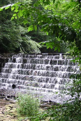
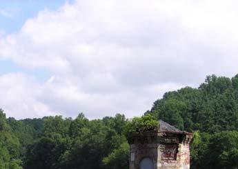
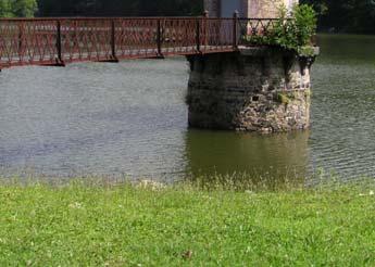
3 navigation of flat bottom boats possible to carry agricultural products to the markets of Philadelphia, and later by the county's early lead in steam railroad growth. Reading's industrial complex attracted a considerable amount of immigrant labor during the late 19 th and early 20 th centuries, an era of great industrial growth for Berks County. Today, the City of Reading remains the county's largest municipality, based on population. There are 29 boroughs, and 44 townships in the county with approximately half of these boroughs located within the urbanized area surrounding Reading. 1 Lower Alsace Township The history of Lower Alsace shows the Lenni Lenape Indians were the first occupants. By 1710, a group of Germans settled the area. In 1888, Alsace Township was divided into two parts; Alsace Township and Lower Alsace Township. Through the 19 th and early 20 th century Lower Alsace was a rural community with orchards, vineyards, small farms and many resort stops and picnic groves along the Gravity Trolley Railroad route on Mt. Penn Mountain. The suburban boom of the 1920's and 1930's brought on intense residential development to the Pennside and Stony Creek areas. 2 Antietam Lake The origins of Antietam Lake date back to 1865 when the City of Reading purchased a dam and gristmill on Antietam Creek as a water supply for the City. The location was favored for a water supply because water could flow by gravity to the City. The dam was enlarged in 1872 and again in 1880 to a capacity of 101,000,000 gallons. The new dam was constructed of huge dressed boulders and the sides of the entire reservoir were riprapped to prevent erosion. The maximum depth of the lake was 45 feet. In 1915, the dam was reconstructed to add a 30 foot wide spillway. Water flows over the 60 foot high solid rock wall which was designed as a natural waterfall. The rock of the waterfall has been studied by generations of geologists and their students and is thought to be billion years old. A unique feature of Antietam Lake is the octagonal brick valve house on a stone foundation set within the lake. This structure was built in 1880 to house the valve controls for the dam. A wooden bridge extends from the shore to the structure. A caretaker s house was also developed in 1880 across Angora Road from the valve house. In 1894, studies found that water from Lake Antietam was contaminated as a result of barnyard runoff. The City of Reading Board of Water Commissioners addressed the crisis by purchasing all surrounding farms within the area and removing the buildings. This was the first purchased primary watershed in the United States. The only remaining buildings were the Bingaman house and barn located on Hill Road. This building has seen many uses since that time, most recently as the City of Reading Department of Recreation Nature Center. Additional improvements were undertaken to enhance water quality of the lake. The Hinnershitz mill dam on Antietam Creek was rebuilt in 1888 to include a settling basin to collect sediment and prevent it from reaching Antietam Lake. The wall below this dam was straightened. A second settling basin was constructed at the mouth of the lake in This basin was configured with a dam of seven stone steps. Water flows over the steps into Antietam Lake. A third settling basin was developed where Bingaman s Run flows into the lake. 1 Scogna, Kathy M. The Birth of a County Berkshistory.org November 9, About Us, History. latownship.org November 9, Chapter 1 2 Antietam Lake Park Master Plan

4 The land surrounding Antietam Lake was reforested in the early 1900 s to prevent soil erosion. A tree nursery was developed on site to provide evergreen seedlings for transplanting throughout the Antietam Lake watershed. Antietam Lake was officially closed as a water reservoir in In 1989, the spillway of the lake was lowered 4 6 for safety concerns. The lower elevation left the Bingaman s Run settling basins higher than the lake, allowing Bingaman s Run to bypass the basins and discharge directly into the lake. In 1998, Antietam Lake was among several properties considered for sale by the City of Reading. The possibility of Antietam Lake property being developed spurred citizens to mobilize as Friends of Antietam Lake in Finally, in 2008, the Antietam Lake property was sold by the City of Reading to the County of Berks. Source: Antietam Lake history summarized from: Historical Review of Berks County, volume 74, number 1, Winter, , The City s Oasis: Antietam Dam, Beulah B. Fehr. Schuylkill River National & State Heritage Area Antietam Lake Park is located within the Schuylkill River National and State Heritage Area. The Schuylkill River National Heritage Area celebrates the rich culture and history of the Schuylkill River watershed as one of America's most significant cultural and industrial regions. The boundaries of the heritage area cover the Schuylkill River watershed in Schuylkill, Berks, Chester, Montgomery, and Philadelphia Counties. The region is nationally significant for the role that its people, places, and events played in the American, Industrial, and Environmental Revolutions. 3 A National Heritage Area is a place designated by the United States Congress where natural, cultural, historic and recreational resources combine to form a cohesive, nationally distinctive landscape. The Schuylkill River received this designation from Congress in The Schuylkill River watershed was designated a Pennsylvania Heritage Area by the Department of Conservation and Natural Resources in National Heritage Areas work to revitalize and restore the region through natural and cultural resource preservation, education, recreation, community revitalization, and heritage tourism The Berks County Greenway, Park and Recreation Plan In 2007, Berks County adopted a Greenway, Park and Recreation Plan. The plan sets specific goals for the direction Berks County should take to provide future open space, greenway, and recreation for its citizens and provides recommendations for the preservation of the county's historic sites and districts. The plan addressed Antietam Lake and outlined the following initiatives: Develop Antietam Preserve as a County Park to preserve ecological resources, while promoting passive recreational, environmental education, and scenic resources. Specific actions steps that 3 About Us: Schuylkill River Heritage Area, schuylkillriver.org/about_us, November 23, 2010, 4 Ibid. Antietam Lake Park Master Plan Chapter 1 3
5 have been completed include the acquisition and preparation of boundary survey and GIS assessment, while other actions are currently moving forward to include this master plan, repair of the dam, signage, and preparation of a brochure and map. Berks Vision 2020 The Future Land Use Plan for the Berks Vision 2020, the county s comprehensive plan consists of six major categories of land use. The following future land use vision pertains to Antietam Lake Park: Permanent Open Space and Recreation create a permanent network of adequate and diverse open space, park and recreational resources for the use of all County residents. A wide range of recreational experiences should be provided, which consist of active recreation, passive park opportunities, and natural open space and conservation environments that secure irreplaceable, unique or threatened natural features and resources. A countywide greenway system interconnecting the County s major park, recreation and open space resources through a network of open space corridors and linear parks and trails is advocated. Rural Conservation Natural features and resources to be conserved include, but are not limited to prime timber stands or large contiguous tracts of woodland (especially in combination with steep slopes), moderate to steep slopes, ridgelines, headwaters for streams, springs, rock outcrops, identified natural areas and locations of animal and plant species of special concern, and wildlife habitat. Demographics The 2000 U.S. Census population for Berks County increased 11 percent from 1990 and estimates show that that growth has continued into the next decade. Alsace Township and the City of Reading both gained population from 1990 and 2000, but at a modest rate relative to the county as a whole. Lower Alsace Township lost population in the same time period. Government Subdivision 2006 Estimated Population 2000 Population 1990 Population Percent Change Lower Alsace Township 4,487 4,478 4, % Alsace Township 3,758 3,689 3, % City of Reading 81,183 81,207 78, % Berks County 401, , , % Berks County s population is diverse racially with the Hispanic population comprising 9.7 percent of the overall population and white population comprising 88.2 percent of the total county population. The 2000 median household income for Berks County was $44,714 which is above the Commonwealth of Pennsylvania s median income of $40,106 per household. The median age of Berks County residents is 37.4 years which compares closely to the statewide median age of 38.0 years. Countywide, 24.6 percent of the population is under 18 years of age and 15.0 percent is 65 years old or older. These statistics illustrate the county base from which the county parks will draw local visitors. A full Demographic Profile Table is provided in Appendix A. Chapter 1 4 Antietam Lake Park Master Plan
6 Master Planning Process The Antietam Lake Park Master Plan planning process included five parts: 1. Inventory and Assessment 2. Public Participation 3. Development of Conceptual Alternatives and Pre Final Designs 4. Final Master Plan 5. Strategic Operations and Management Plan 1. Inventory and Assessment The natural resources and existing features of the park site were explored. Landscape architects, ecologists, an architect, and a recreation planner, visited Antietam Lake Park several times throughout the planning process to evaluate the site and its features and natural resource characteristics, observe site opportunities, and consider potential impact of public use on the park site and surrounding land uses. This assessment guided the master planning process. Chapter 3 Resources of Antietam Lake Park documents the findings of the inventory and assessment phase of the planning process. 2. Public Participation To assure that the design for the park is community based, broad citizen input was critical to the planning process. Public input was gathered by working with a study committee, completing interviews with stakeholders, and conducting a public meeting. Additionally, input from meetings regarding the park site that preceded this planning process was reviewed. 3. Development of Conceptual Alternative Designs Conceptual alternative designs were developed for the park. The alternatives presented differing approaches to achieving site and recreation goals and locations of proposed improvements. Following review of the alternative designs, a pre final design was developed. The pre final design was shared with citizens at a public meeting and additional input was gathered about the ideas and park facilities presented. 4. Final Master Plans The final master plan for Antietam Lake Park was developed based on the outcomes and conclusions of the planning process. Probable construction cost opinions and a phasing plan for implementation of the final master plan were completed in this phase of work. 5. Strategic Operations and Management Plan Park operations are the most significant lifetime cost of a park. Recommendations for operation, management, maintenance, and financing the park improvements were defined for Antietam Lake Park. Antietam Lake Park Master Plan Chapter 1 5
Town of Peru Comprehensive Plan Executive Summary
 Town of Peru Comprehensive Plan Executive Communities that plan grow by choice, not by chance. A plan makes growth thoughtful, understandable, and predictable. A plan shows that a community is managing
Preface. Erie. Scranton. Allentown. Pittsburgh. Harrisburg. Philadelphia
 The Southern Alleghenies Region The Southern Alleghenies Region spans the Laurel Highlands and Allegheny Front in the west across the Appalachians to the east. It is comprised of Blair, Bedford, Cambria,
TABLE OF CONTENTS. Transportation Chapter 1 - Introduction and Purpose of Planning to 1-3. Utilities
 Chapter 1 - Introduction and Purpose of Planning... 1-1 to 1-3 Pennsylvania Municipalities Planning Code (Act 247)...1-1 Previous County Planning Activities...1-1 Objectives of the Plan...1-2 Elements
INTRODUCTION PLANNING HISTORY
 INTRODUCTION The Upper Rock Creek Master Plan Area lies in the east central part of Montgomery County. The Master Plan Area is adjacent to the City of Rockville to the south, the Olney Planning Area to
Executive Summary Purpose of the Plan Defining Open Space and Greenways
 Executive Summary Bucks County possesses a vast array of open space resources including natural areas, parks, farmland and historic and cultural resources that contribute to a high quality of life valued
Statewide Greenways Vision
 Greenways Vision The formation of a greenways vision is based on a thorough analysis of the current state of recreation and open space in a region and the existing pressures that threaten it. Lehigh and
Pinellas County Greenways
 Pinellas County Greenways USING GREENWAYS TO LINK OPEN SPACES The Florida Greenways Commission has defined a greenway as...a corridor of protected open space that is managed for conservation and/or recreation.
Mendota Heights 2040 Comprehensive Plan Draft Vers
 4 Parks and Trails The City of Mendota Heights boasts a variety of recreational and open space opportunities. Few cities can claim access to regional trails, riverside and lakeside parks, scenic bluffs
Whitemarsh Township Greenway Plan
 Whitemarsh Township Greenway Plan Prepared for: Whitemarsh Township August 16, 2007 Table of Contents Table of Contents... i Introduction... 1 Study Area Setting... 2 Regional Setting... 2 Township Character...
CHAPTER 1 Introduction
 CHAPTER 1 Introduction From sea to summit, Lane County covers almost 4,800 square miles of diverse Oregon landscape. Stretching from the Pacific Ocean through the Coastal Range, the Willamette Valley to
UPPER BRODHEAD CREEK PARADISE CREEK GREENWAY PLAN
 UPPER BRODHEAD CREEK PARADISE CREEK GREENWAY PLAN The Upper Brodhead & Paradise Creeks Greenway Cooperating Municipalities Mount Pocono Borough Paradise Township Barrett Township Price Township Funding
CHAPTER 2 COMMUNITY DEVELOPMENT GOALS AND OBJECTIVES VISION FOR AMITY-EXETER-ST. LAWRENCE REGION
 CHAPTER 2 COMMUNITY DEVELOPMENT GOALS AND OBJECTIVES VISION FOR AMITY-EXETER-ST. LAWRENCE REGION The municipalities of Amity, Exeter, and St. Lawrence will actively strive to maintain and enhance the quality
City of Missoula and Missoula County Open Space Planning Open House
 City of Missoula and Missoula County Open Space Planning Open House FEBRUARY 6, 2018 The following slides contain the display board content from the open house. Please use boards to answer questions in
Riparian Buffer on the Bushkill Creek. Policies
 Riparian Buffer on the Bushkill Creek Riparian buffers provide numerous benefits to landowners and the community by protecting groundwater recharge areas, providing flood control, providing stormwater
SECTION FOUR: MISSION STATEMENT, GOALS & OBJECTIVES
 SECTION FOUR: MISSION STATEMENT, GOALS & OBJECTIVES Chapter Summary Chapter Ten: Mission Statement, Goals & Objectives To fulfill its mission, the Parks and Recreation Commission has identified four basic
CHAPTER 4 FUTURE LAND USE AND URBAN SERVICES DISTRICTS
 CHAPTER 4 FUTURE LAND USE AND URBAN SERVICES DISTRICTS Introduction This chapter discusses how Benzie County should grow and change in the future. A community can grow and change in many different ways.
CHAPTER 5 Antietam Lake Park Master Plan
 CHAPTER 5 Antietam Lake Park Master Plan Introduction The Antietam Lake Park Master Plan illustrates the overall vision for the park, the physical configuration of proposed improvements, and strategies
INTRODUCTION Key Issues and Findings Goals, Objectives, and Policies - Natural Resources - Map M18 - Environmental Resources
 Natural, Environmental, Cu INTRODUCTION This Element provides policies related to the preservation and protection of the Centre Region s natural, environmental, cultural, and historic resources. This Element
Lake O the Pines Master Plan Revision Public Information Meeting April 25 & 27, 2017
 Lake O the Pines Master Plan Revision Public Information Meeting April 25 & 27, 2017 Presented By Matthew Like, Lake Manager U.S. Army Corps of Engineers Fort Worth District US Army Corps of Engineers
PARKS AND RECREATION
 PARKS AND RECREATION WHAT YOU WILL FIND IN THIS CHAPTER: Background information on the development of the Park, Recreation, and System Plan (PRSP). General overview of Ellensburg s parks and recreation
APPENDIX A 6 CONCEPTUAL PRELIMINARY PLAN GUIDE AND CHECKLIST FOR MAJOR SUBDIVISIONS CARRBORO DEVELOPMENT GUIDE APPENDIX A
 6 CONCEPTUAL PRELIMINARY PLAN GUIDE AND CHECKLIST FOR MAJOR SUBDIVISIONS Conceptual Preliminary Guide/Checklist for Major Subdivisions Page 1 FORM: REVIEW DATE: CONCEPTUAL PLAN REVIEW 2000 REVIEWED BY:
Chapter 5: Recreation
 Chapter 5: Recreation Introduction and Setting Recreational opportunities within Nevada County are varied, ranging from public parks with intensively used active recreational facilities, to vast tracts
Chapter 13: Implementation Plan
 Implementation A. Introduction The Implementation Plan, in table form on the following pages, provides a summary of all the Action Items recommended in Chapters 2 through 12. The table also indicates which
Chairman and Members of the Planning and Development Committee. Thomas S. Mokrzycki, Commissioner of Planning and Building
 LA.09.TOR (Toronto) DATE: TO: FROM: SUBJECT: Chairman and Members of the Planning and Development Committee Thomas S. Mokrzycki, Commissioner of Planning and Building Central Waterfront Secondary Plan
Public Information Meeting
 Lavon Lake Master Plan Revision Public Information Meeting March 10, 2015 Presented By Michael Kinard Lake Manager U.S. Army Corps of Engineers Fort Worth District US Army Corps of Engineers Purpose of
PREVIOUS PUBLIC PARTICIPATION BRIEF October 2014
 Comprehensive Planning During the development of the county comprehensive plan, Cultivating Community: A Plan for Union County s Future from 2007 through 2009, and three concurrent multi municipal plans
Environmental Protection Ordinances (Performance Zoning) Bedminster Township, Bucks County
 Bedminster Township, Bucks County") Environmental Protection Ordinances (Performance Zoning) Bedminster Township, Bucks County ARTICLE VI. PERFORMANCE STANDARDS Section 600 Compliance All uses, activities, subdivisions and/or land developments
Environmental Protection Ordinances (Performance Zoning) Bedminster Township, Bucks County ARTICLE VI. PERFORMANCE STANDARDS Section 600 Compliance All uses, activities, subdivisions and/or land developments
Chapter 5: Natural Resources and Environment
 NATURAL RESOURCES AND ENVIRONMENT 5-1 5 Chapter 5: Natural Resources and Environment BACKGROUND AND INTENT Urban expansion represents the greatest risk for the future degradation of existing natural areas,
SECTION 1 Introduction...1. SECTION 2 Regional Context Criteria for Planning Districts Description of Planning District...
 Table of Contents SECTION 1 Introduction...1 SECTION 2 Regional Context...2 2.1 - Criteria for Planning Districts...2 2.2 - Description of Planning District...2 SECTION 3 Goals & Objectives...5 SECTION
Introduction to the Shoreline Master Program (SMP) Update. City of Bellingham Planning Department 2005
 Update. City of Bellingham Planning Department 2005") Introduction to the Shoreline Master Program (SMP) Update City of Bellingham Planning Department 2005 Purpose of tonight s meeting: Specify which water-bodies are subject to the SMP. Identify the State
Introduction to the Shoreline Master Program (SMP) Update City of Bellingham Planning Department 2005 Purpose of tonight s meeting: Specify which water-bodies are subject to the SMP. Identify the State
Recreation, Open Space, Greenway Plan & Smart Agriculture Initiative
 Recreation, Open Space, Greenway Plan & Smart Agriculture Initiative This portion of the Plan represents a follow-up to Section 2, which addressed the natural environment of the two townships. This portion
Schuylkill River Greenway
 Schuylkill River Greenway Opportunities DRAFT July, 2010 1 Schuylkill River Greenway bringing new life to Montgomery County's hidden waterway. Schuylkill River Greenway... Celebrating and maintaining
SUMMARY. A Special Place in Our Nation s History
 SUMMARY SUMMARY A Special Place in Our Nation s History Few places in America can claim the Schuylkill River Valley s importance in history. A variety of peoples from the Lenni Lenapi to the first European
Oakland County s Green Infrastructure Vision. L. Brooks Patterson Oakland County Executive
 Oakland County s Green Infrastructure Vision L. Brooks Patterson Oakland County Executive Southeast Michigan 20 miles northwest of Detroit Consists of 910 square miles Population of 1.2 million More than
Natural Areas Inventory Update. Executive Summary
 Montgomery County planning commission Natural Areas Inventory Update Executive Summary Executive Summary Despite continuing development and resulting suburban sprawl, significant areas of open space remain
RECREATION, OPEN SPACE AND GREENWAYS ELEMENT GOALS, OBJECTIVES, AND POLICIES
 RECREATION, OPEN SPACE AND GREENWAYS ELEMENT GOALS, OBJECTIVES, AND POLICIES GOAL R-1: DEVELOP A RECREATION, OPEN SPACE AND GREENWAYS SYSTEM AS AN INTEGRAL COMPONENT OF AN OVERALL, COUNTY-WIDE ECONOMIC
Courthouse Planning Area
 Courthouse Planning Area Current Reality The Courthouse Planning Area is the characterized by expansive suburbanscale residential areas as well as the community resource planned area of athletic, educational,
OPEN SPACE PLAN LOWER FREDERICK TOWNSHIP MONTGOMERY COUNTY, PENNSYLVANIA. with 2015 Potential Open Space Linkages Update
 OPEN SPACE PLAN LOWER FREDERICK TOWNSHIP MONTGOMERY COUNTY, PENNSYLVANIA 2006 with 2015 Potential Open Space Linkages Update LOWER FREDERICK TOWNSHIP OFFICIALS P.O. Box 253 Zieglerville, PA 610-287-8857
Woodland Conservation and the Master Plan
 1 WHAT IS A MASTER PLAN? A Vision for the Future of Your Community Woodland Conservation and the Master Plan Goals Objectives Strategies 2 How Will Your Community Look? TREE PRESERVATION AND THE MASTER
CHAPTER 2 GOALS, OBJECTIVES AND POLICIES
 CHAPTER 2 GOALS, OBJECTIVES AND POLICIES The goals, objectives and policies of this Comprehensive Plan Update serve as guidelines for directing future growth, revitalization, development, adaptive reuse
COPLAY BOROUGH COMPREHENSIVE PLAN
 COPLAY BOROUGH COMPREHENSIVE PLAN Lehigh County, Pennsylvania Adopted by Coplay Borough Council on May 11, 2010 Urban Research and Development Corporation Bethlehem, PA with Keystone Consulting Engineers,
Authority of the General Plan
 Authority of the General Plan This La Habra Heights General Plan will serve as the blueprint for future planning and development in the City. This General Plan describes the City s vision for the future
City of Surrey Ecosystem Management Study. Integration of ecological processes with land use
 City of Surrey Ecosystem Management Study Integration of ecological processes with land use Natural areas in Surrey are changing as the City grows and evolves. Many important natural areas remain or may
Green Infrastructure Policies and Ordinances
 Green Infrastructure Policies and Ordinances October 23, 2013 By Karen Firehock, Green Infrastructure Center 2013 Georgia Urban Forest Council s 23 rd Annual Conference The mission of the nonprofit Green
COMMUNITY ENVIRONMENTAL MANAGEMENT
 COMMUNITY ENVIRONMENTAL MANAGEMENT CEM HANDBOOK FOR COMMUNITY CONSERVATION PLANNING ----- Draft ----- Prepared by the CENTER FOR COMMUNITY ENVIRONMENTAL MANAGEMENT in association with the NEW YORK STATE
THREE-STEP DESIGN PROCESS FOR OPEN SPACE SUBDIVISIONS
 00216106.DOC NMA/RRK 1/30/14 THREE-STEP DESIGN PROCESS FOR OPEN SPACE SUBDIVISIONS Open space subdivisions, sometimes called cluster developments, maintain a significant portion of a development site in
Outlawing Sprawl. Pennsylvania Chapter American Planning Association October 6, 2009
 Outlawing Sprawl Pennsylvania Chapter American Planning Association October 6, 2009 Presented by: Ronald T. Bailey, AICP Executive Director Chester County Planning Commission Location: 2009 PA Chapter
Arlington, Virginia is a worldclass
 EXECUTIVE S U M M A RY Arlington maintains a rich variety of stable neighborhoods, quality schools and enlightened land use policies, and received the Environmental Protection Agency s highest award for
City of Surrey Ecosystem Management Study. Integration of ecological processes with land use
 City of Surrey Ecosystem Management Study Integration of ecological processes with land use Natural areas in Surrey are changing as the City grows and evolves. Many important natural areas remain or may
San Diego River Coalition 2012 Work Plan
 San Diego River Coalition 2012 Work Plan Adopted November 18, 2011 The mission of the San Diego River Coalition is preserve and enhance the San Diego River, its watershed, and its natural, cultural and
Executive Summary. Parks and Recreation Plan. Executive Summary
 Parks and Recreation Plan Executive Summary The Whitemarsh Township Parks and Recreation Plan sets forth a vision for how Whitemarsh Township can provide a premiere parks and recreation system reflective
Green Infrastructure. by Karen Engel, NYS DEC. NYS Department of Environmental Conservation
 Green Infrastructure by Karen Engel, NYS DEC What is Green Infrastructure? For some it s all about water Green Infrastructure techniques use soils and vegetation to infiltrate, evapotranspirate, and/or
OPEN SPACE CHAPTER 7: OVERVIEW. Preserve open space to protect natural resources, enhance character and provide passive recreation opportunities
 CHAPTER 7: OPEN SPACE OVERVIEW Ridgefield has made tremendous progress permanently preserving areas of town as open space. Open space preservation can serve many important purposes, including: protect
Appendix F PENNSYLVANIA LOCAL PARKS AND THE COMMUNITIES THEY SERVE
 Appendix F PENNSYLVANIA LOCAL PARKS AND THE COMMUNITIES THEY SERVE August 8, 2014 By The Center for Rural Pennsylvania Profile Data Profiles and Analysis Introduction To assist in the development of the
Chapter 9 Community Facilities & Services Plan. Introduction. Cooperative Efforts. Monitoring of Needs
 Chapter 9 Community Facilities & Services Plan Introduction The location of key community facilities such as water, sewer, schools, parks, and roads is important to the provision of the necessary services
Silverwood Masterplan Kickoff Meeting. Jim Neidhart Dane County Parks Planning
 Silverwood Masterplan Kickoff Meeting Jim Neidhart Dane County Parks Planning 608-224-3614 January 30, 2014 Silverwood County Park Public Information Meeting Notice Sent notice to all landowners adjacent
2/22/2017. Agenda. February 21, 2017 Little Flower Manor Master Site Plan Public Meeting #1
 Agenda February 21, 2017 Little Flower Manor Master Site Plan Public Meeting #1 Project Background and Importance History of the Property Acquisition Relationship to the County Park System Relationship
Lewisville Lake Master Plan Revision Public Information Meeting May 2 & 4, 2017
 Lewisville Lake Master Plan Revision Public Information Meeting May 2 & 4, 2017 Presented By Rob Jordan Lake Manager U.S. Army Corps of Engineers Fort Worth District US Army Corps of Engineers Purpose
Ottawa County Parks, Recreation & Open Space Plan. February, 2006
 2006 Ottawa County Parks, Recreation & Open Space Plan February, 2006 TABLE OF CONTENTS ACKNOWLEDGMENTS.................................................... v PLAN ADOPTION..........................................................vi
Chapter 131 GENERAL REFERENCES
 Chapter 131 STREAM CORRIDOR PROTECTION ZONE 131-1. Objectives. 131-2. Definitions. 131-3. Establishment of the Stream Corridor Protection Zone. 131-4. Uses permitted. 131-5. Uses expressly prohibited.
ARISE: The Rock Renaissance Area Redevelopment & Implementation Strategy
 2014 Professional Awards 1 ARISE: The Rock Renaissance Area Redevelopment & Implementation Strategy Janesville, WI Completed December 2014 Analysis & Planning Purpose of Project 2 The purpose of the Rock
STEWARDSHIP OF LONG ISLAND SOUND S ECOLOGICAL AND RECREATIONAL RESOURCES
 STEWARDSHIP OF LONG ISLAND SOUND S ECOLOGICAL AND RECREATIONAL RESOURCES Robin Kriesberg, Save the Sound, Inc. Thomas Halavik, US Fish and Wildlife Service Coastal Program An Initiative to Identify, Protect
Parks and Open Space Preservation and Dedication. January 26, 2016 Fort Worth City Council Pre-Council Meeting Randle Harwood and Richard Zavala
 Parks and Open Space Preservation and Dedication January 26, 2016 Fort Worth City Council Pre-Council Meeting Randle Harwood and Richard Zavala Purpose How does the City of Fort Worth preserve and protect
Westmoreland County Greenways Plan
 Westmoreland County Greenways Plan Citizens Advisory Board Review Draft April 2007 Prepared for: Westmoreland County and Smart Growth Partnership of Westmoreland County Prepared by: Environmental Planning
Carrboro Greenways Commission January 9 th, 2007
 Carrboro Greenways Commission January 9 th, 2007 Statewide The flooding of Crabtree Valley in the early 1970 s (right before Crabtree Valley Mall was set to open) caused city, state, and federal officials
Master Plan Objectives and Policies
 Master Plan Objectives and Policies Introduction This chapter identifies the Park issues and recommended policies established by this Master Plan. The issues were identified through meetings with staff,
Draft Stillwater 2030 Comprehensive Plan- Goals and Policies
 Draft Stillwater 2030 Comprehensive Plan- Goals and Policies Instructions- Review each goal and policy and discuss with group any changes, deletions for additions to the list using your groups pen. Keep
2018 Northampton Township Comprehensive Plan
 2018 BUCKS COUNTY, PENNSYLVANIA What is a? A comprehensive plan is a municipality s main policy document that details the collective vision for the future, the historic, environmental, and cultural facilities
Exhibit A. 8:9 Scuffletown Rural Conservation District
 Exhibit A 8:9 Scuffletown Rural Conservation District 8:9.1 Intent and Purpose The Scuffletown Rural Conservation (SRC) District is intended to provide for residential development that supports the development
ADOPTED CAPITAL IMPROVEMENT PROGRAM BUDGET ARROYO PROJECTS
 ADOPTED CAPITAL IMPROVEMENT PROGRAM BUDGET ARROYO PROJECTS HAHAMONGNA FY 212-216 Capital Improvement Program Priority Description Total Estimated Costs Appropriated Through FY 211 Adopted FY 212 FY 213
Zoning Ordinance Article 3
 Article 3 Natural Resources Protection Section 301 Natural Resources Protection 301.1. Purpose - The following natural resources protection standards are established to protect the public health, safety
City of Royalton Comprehensive Land Use Plan 2005 to Revision February 8, 2011
 City of Royalton Comprehensive Land Use Plan 2005 to 2015 2011 Revision February 8, 2011 PART ONE: INTRODUCTION TO THE COMPREHENSIVE PLAN 1.0 Purpose and Introduction The Comprehensive Land Use Plan provides
Protecting Farmland. The Future of Agriculture in Prince George s County
 Protecting Farmland As demonstrated in the previous section, farmland in Prince George s County is disappearing at a rapid pace. If the loss of farmland continues at this rate, no farmland will be left
I. STAFF POLICY RECOMMENDATIONS. The following RMP policy strategies are proposed by staff in support of a Scenic Resource Protection Program:
 Policy Consideration: Scenic Resource Protection Program Status: For Consideration by the Highlands Council at September 14, 2006 Work session Date: September 12, 2006 I. STAFF POLICY RECOMMENDATIONS The
Open Space and Farmland Preservation
 Vibrant. Green. Connected. Competitive. Open Space and Farmland Preservation Statement of Purpose The purpose of this section of the Plan is to encourage and support the preservation of open space areas
Ten Mile Creek Planning Area
 PLANNING AREA POLICIES TEN MILE CREEK Ten Mile Creek Planning Area Location and Context The Ten Mile Creek Planning Area ( Ten Mile Creek area ) is located south of the current Boise AOCI, generally south
Countywide Green Infrastructure
 Montgomery County s Countywide Green Infrastructure F U N C T I O N A L M A S T E R P L A N The Maryland National Capital Park and Planning Commission INFRASTRUCTURE An underlying base or foundation especially
Request for Statement of Interest in Implementation of the Roosevelt Road Redevelopment Plan
 425 Hillside Avenue Request for Statement of Interest in Implementation of the Roosevelt Road Redevelopment Plan I. INTRODUCTION The is seeking the services of a qualified consulting firm to prepare plans
Master Plan for Preservation and Scenic Conservation (1995)
") 3.2 Master Plan for Preservation and Scenic Conservation (1995) The Master Plan for Preservation and Scenic Conservation was developed under the direction of the Guilford Preservation Alliance in the 1980s
3.2 Master Plan for Preservation and Scenic Conservation (1995) The Master Plan for Preservation and Scenic Conservation was developed under the direction of the Guilford Preservation Alliance in the 1980s
APPENDIX I Presentations
 APPENDIX I Presentations Workshop Summary Report 11 Peel Region Official Plan Review May 5, 2010 Compatible Active Recreation Workshop July 29, 2010 Components of PROPR Sustainability Planning Tools/Updates
OPEN SPACE AND RECREATION
 OPEN SPACE AND RECREATION The Town celebrates and maintains the spectacular visual character of our Sonoran Desert setting and we value our open space, mountain views, washes, vegetation, and wildlife.
Fresh Kills Park in Regional Context
 Fresh Kills Park in Regional Context Fresh Kills Location On Staten Island Community District 1 THE SITE TODAY TRAVIS William T. Davis Wildlife Refuge New Jersey NEW SPRINGVILLE MOUND 3/4 Little Fresh
Canyon Lake Master Plan Revision Public Information Meeting March 18, 2016
 Canyon Lake Master Plan Revision Public Information Meeting March 18, 2016 Marcus Schimank Canyon Lake Manager Capital Regional Office U.S. Army Corps of Engineers Fort Worth District US Army Corps of
Elliot Park 2. Neighborhood Master Plan. Historical Perspective
 Elliot Park 2 Neighborhood Master Plan Historical Perspective August 2002 Early History Development patterns and the growth of Minneapolis largely grew out of the city s historical response to its geography.
Chapter 2: About the Northern Chester County Region
 Chapter 2: About the Northern Chester County Region OUR LANDSCAPE The Northern Chester County region ((the Region)) lies at the juncture of historically and currently significant landscapes the the Schuylkill
OPEN SPACE, PARKS, AND HISTORIC SITES
 OPEN SPACE, PARKS, AND HISTORIC SITES The conservation of land, water, and historic resources, and the related provision of recreation opportunities, is one of the most important factors in maintaining
This page intentionally blank.
 This page intentionally blank. Parks, Recreation, and Open Space Chapter Relationship to Vision Vision Parks, Recreation and Open Space Chapter Concepts County Government. County government that is accountable
CITY CLERK. Parkland Acquisition Strategic Directions Report (All Wards)
") CITY CLERK Clause embodied in Report No. 10 of the, as adopted by the Council of the City of Toronto at its meeting held on November 6, 7 and 8, 2001. 10 Parkland Acquisition Strategic Directions Report
CITY CLERK Clause embodied in Report No. 10 of the, as adopted by the Council of the City of Toronto at its meeting held on November 6, 7 and 8, 2001. 10 Parkland Acquisition Strategic Directions Report
Policy & Procedure Effective Date: Parks Department Page of
 City of Arvada Policy & Procedure Effective Date: Parks Department Page of TITLE: City of Arvada Prairie Dog Habitat Plan APPROVAL: PURPOSE: To establish a plan for the preservation of black-tailed prairie
Innovative Land Use Techniques
 Innovative Land Use Techniques A Handbook for Sustainable Development Eric Williams, Assistant Administrator, NHDES Carolyn Russell, Principal Planner, NHDES Cliff Sinnott, Executive Director, RPC Jill
TOWN OF SPRINGFIELD, NEW HAMPSHIRE
 TOWN OF SPRINGFIELD, NEW HAMPSHIRE NATURAL RESOURCES INVENTORY EXECUTIVE SUMMARY March 2008 Prepared by: Watershed to Wildlife, Inc. Natural Resource Consultants 42 Mill Street, Suite 3 Littleton, NH 03561
Eightmile River O F A. COOPERATIVE EXTENSION SYSTEM College of Agriculture and Natural Resources
 W E L C O M E T O T H E Eightmile River W A T E R S H E D T H E H E A R T O F A L A S T G R E A T P L A C E COOPERATIVE EXTENSION SYSTEM College of Agriculture and Natural Resources The Connecticut River
National Fish & Wildlife Foundation Delaware River Restoration Fund 2014 Award Descriptions
 National Fish & Wildlife Foundation Delaware River Restoration Fund 2014 Award Descriptions Restoring Paulins Kill Floodplain Forests and Functions ( Highlands) $99,759 Barrett s Run Afforestation and
The Recreational Heart of Cannington - MacLeod & Claire Hardy Parks
 The Site Claire Hardy Park and MacLeod Park are both located within the community of Cannington on opposing shorelines of the Beaver River and are accessible to each other by a footbridge spanning the
Oregon SCORP. Assessing Recreation Demand & Supply
 2013-2017 Oregon SCORP Assessing Recreation Demand & Supply SORP Conference: April 13, 2015 2013-2017 Oregon SCORP Supply/Demand Planning Components A County-Level and Regional Planning Approach Oregon
1.0 THE PLANNING CONTEXT
 1.0 THE PLANNING CONTEXT 1.0 THE PLANNING CONTEXT 1.1 PROJECT LOCATION AND BACKGROUND The Schuylkill River Valley National Heritage Area is located in southeastern Pennsylvania within the drainage area
RECOMMENDATIONS. Design Recommendations
 RECOMMENDATIONS While the San Diego River Park will serve to unify the river as a whole, each reach of the river park maintains distinct resources and character. Recommendations for each reach have been
Pennsylvania Stormwater Best Management Practices Manual. Chapter 1. Introduction and Purpose
 Pennsylvania Stormwater Best Management Practices Manual Chapter 1 Introduction and Purpose Chapter 1 Introduction and Purpose 1.1 Purpose of this Manual 1 1.2 How to Use this Manual...1 1.3 Overview
6.0 Conclusions & Recommendations
 6.0 Conclusions & Recommendations 75 The research, public outreach and feasibility analysis completed for this study indicate that Trail Alternative #2 (South side of Doctors Creek) is the most comprehensive
4. What are the goals of the Kawarthas, Naturally Connected project? 7. What are watersheds and why are they being used as the project boundaries?
 Frequently Asked Questions (FAQs) 1. What are Natural Heritage Systems (NHS)? 2. Why are they important? 3. Which areas of the province have undertaken NHS projects? 4. What are the goals of the Kawarthas,