2013 CAMPUS MASTER PLAN UPDATE
|
|
|
- Adele Carroll
- 5 years ago
- Views:
Transcription
1 The University of North Carolina at Greensboro 2013 CAMPUS MASTER PLAN UPDATE Board of Trustees December 6, 2013 MASTER PLAN GOALS 1. Plan for an engaging, collaborative learning environment that aligns with the UNCG Strategic Direction, Mission, and Vision 2. Maintain realistic expectations within the current fiscal outlook 3. Conduct an open, inclusive and transparent planning process 4. Recognize internal and external plans for growth, particularly in the Lee Street corridor 5. Provide guidance for the character and quality of future campus development 6. Address sustainability in the maintenance, operation, and growth of campus 7. Plan for a safe pedestrian, bicycle, and vehicular environment, taking into account the recently updated Transportation Master Plan 1
2 WHAT WE HEARD MyCampus Survey 272 RESPONSES Green spaces and pedestrian malls are important to campus character. Students want good quality, affordable housing on campus. Students want more dining options on Tate and Lee Streets, more places for meeting, and better connectivity among Dining Hall, library, and EUC. Students value the campus landscape and want it pulled across to the Lee Street Corridor. Students value sustainability on campus and want to see more sustainability efforts. Students are most concerned about safety at the periphery of campus. MASTER PLAN 4 2


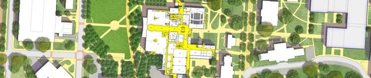
3 EXISTING CONDITIONS MASTER PLAN CONCEPT Natural Area Campus Center Spring Garden Gateway Pedestrian Underpass Lee Street Corridor Glen 6 3
4 MASTER PLAN CONCEPT Central northsouth corridor Reinforce transit hub Strengthen Kaplan Commons Introduce additional core buildings Add forest to Forest Street Integrate transit hub Promote pedestrian use of Union Street 7 MASTER PLAN CONCEPT Walker Ave East-west connections Library corridor Pedestrian walkway Engage with the Lee Street Corridor 8 4
5 MASTER PLAN 9 Master Plan Elements 10 5

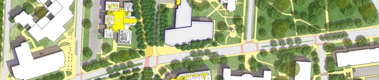
6 MASTER PLAN EUC Green Forest St Lee Street Corridor 11 LEE STREET Existing 6


7 LEE STREET Existing Parking Side walk Drive Way Turning Lane Drive Way Side walk Existing Retail LEE STREET Proposed Student Housing Retail Parking Side walk Drive Way Drive Way Turning Lane Drive Way Drive Way Side walk Setback Retail Bus Stop


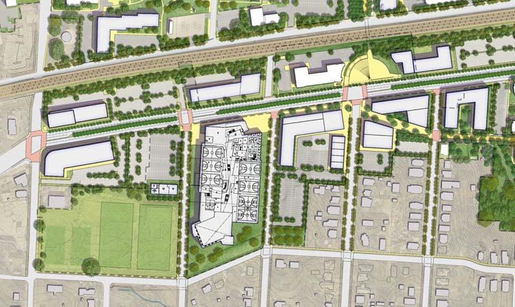
8 LEE STREET CORRIDOR Existing Proposed 15 LEE STREET CORRIDOR - West 16 8


9 LEE STREET CORRIDOR - East 17 Promote a new campus center and create a campus environment along Lee Street Promote Union Street as a pedestrian connector from Lee Street to The Glen Create a vibrant landscape to promote the new campus center and retail businesses Enhance pedestrian safety LEE GLENWOOD 18 9
 Student Housing Student")

10 UNION STREET Pedestrian Connector Proposed (looking northwest) Student Housing Student Housing Retail/ Restaurant LLC Retail Planting/ Lawn Promenade Spartan Village Bldg #6 19 LLCs 10


11 FOREST STREET Existing Proposed EUC Oakland Deck McNutt 21 11


12 FOREST STREET Proposed Oakland Deck McNutt McNutt Oakland Deck 23 FOREST STREET Existing Oakland Ave Parking Deck McNutt Planting Area Side walk Driveway Side walk Parking ~

13 FOREST STREET Proposed Oakland Ave Parking Deck Future Expansion McNutt Planting / Lawn / Seating Promenade Planting / Lawn / Seating Bike/ Service Access Planting / Lawn / Seating Shaded seating Separate pedestrian and bicycle routes McNutt expansion engages with pedestrian spine 25 FOREST STREET Proposed Oakland Deck McNutt McNutt Oakland Deck 26 13


14 FOREST STREET (Proposed) Establish build-to lines along Forest Street Create a continuous shaded landscape character Promote a safe pedestrian street Reinforce the pedestrian spine and underpass with landscape features 27 FOREST STREET Proposed 14


15 FOREST MOSSMAN Proposed Library EUC Mossman 29 15


16 FOREST MOSSMAN Proposed Mossman New entry to Mossman provides direct access to pedestrian spine; opportunity to re-purpose building Promenade 16 Wide promenade accommodates pedestrians and cyclists Buffer Landscape Landscape buffer hides EUC service access Forest Street Service Area 31 EUC GREEN Existing Proposed Dining EUC 32 16


17 EUC GREEN Proposed Library EUC Mossman 34 17

 Library EUC")
18 West Library expansion and transit hub Strong pedestrian spine Key east-west corridor EUC GREEN Proposed Kaplan Commons is strengthened as the campus center 35 EUC GREEN (Proposed) Library EUC Mossman 36 18
19 19

20 Transit hub connects directly to Library Hall addition Informal seating and gathering spaces provides opportunity for indoor and outdoor study Jackson Library Future Library Hall Tree Bosque and Outdoor Study Area Transit Hub / Bus Stop Promenade Library Plaza Tree Bosque Seating Area / Access to Existing Library s Entry LIBRARY COMMONS 20

21 Transit hub connects directly to Library Hall addition Informal seating and gathering spaces provides opportunity for indoor and outdoor study Jackson Library Future Library Hall Tree Bosque and Outdoor Study Area Transit Hub / Bus Stop Promenade Library Plaza Tree Bosque Seating Area / Access to Existing Library s Entry


22 OUTDOOR STUDY OUTDOOR STUDY UNIVERSITY OF ST. EDWARDS, AUSTIN PERFOMANCE : : shade : : respond to local climate 22

23 LIBRARY Interior Circulation Library EUC Mossman 45 23
24 24


25 LIBRARY Learning Commons LIBRARY Learning Commons 25


26 ADDITIONAL BUILDINGS OF INTEREST McIver Street Properties McIver Replacement Weatherspoon Addition Additional Housing 51 MASTER PLAN 52 26
27 27
Overview and Update of the Rutgers-New Brunswick Physical Master Plan. January 2015
 Overview and Update of the Rutgers-New Brunswick Physical Master Plan January 2015 Failure To Plan, is Planning For Failure Winston Churchill 2 Good Planning; The Key to Success 3 The university physical
ELMVALE ACRES SHOPPING CENTRE MASTER PLAN
 ELMVALE ACRES SHOPPING CENTRE MASTER PLAN Contents 1.0 INTRODUCTION... 2 2.0 LOCATION... 2 3.0 EXISTING CONTEXT... 2 4.0 VISION & GUIDING PRINCIPLES... 2 5.0 LAND USE AND BUILT FORM... 4 5.1 St. Laurent
UNIVERSITY OF KENTUCKY 2012 Campus Plan Update. Ross Tarrant Architects
 UNIVERSITY OF KENTUCKY 2012 Campus Plan Update AGENDA TEAM 1 2 3 4 5 ENGAGEMENT PUBLIC INPUT PROCESS GOALS AND OBJECTIVES PLANNING PROCESS AND SCHEDULE TOPICS AND DISCUSSION Team SASAKI UNIVERSITY OF PENNSYLVANIA
UNCW CAMPUS MASTER PLAN
 UNCW CAMPUS MASTER PLAN JULY 27, 2017 MASTER PLAN FRAMEWORK RECOMMENDATIONS BOARD OF TRUSTEES PRESENTATION UNCW Campus Master Plan Update Board of Trustees Presentation July 27, 2017 The attached Campus
Lambeth Main Street Streetscape Improvements
 Lambeth Main Street Streetscape Improvements Open House October 5th, 2017 Agenda 1. Introduction 2. Project Background 3. Context 4. Project Objectives 5. Design Principles & Approach 6. Streetscape Design
THE NEIGHBORHOOD TODAY
 THE NEIGHBORHOOD TODAY CORE AREA VISION How are we Good Urbanism A Site s DNA thinking about Elements of great Unique elements urban communities embedded in a place the site and design? ELEMENTS LIKE:
appendix and street interface guidelines
 appendix five: building and street interface guidelines appendix 5 building and street interface guidelines BOULEVARDS Boulevards are generally characterized by higher levels of traffic movement at higher
Subcampus Recommendations
 T he campus is is comprised of three major areas. These subcampus areas are known as WestCampus, South Campus, Campus Oakland and Drive East Campus. and Future East growth Campus. requires a Future careful
Courthouse Square Planning & Urban Design Study. Courthouse Square Working Group #13 October 15, 2014
 Courthouse Square Planning & Urban Design Study Courthouse Square Working Group #13 October 15, 2014 1 Courthouse Square Process Working Group Community Courthouse Square Advisory Groups & Civic Associations
Lehigh Acres Land Development Regulations Community Planning Project
 Lehigh Acres Land Development Regulations Planning Effort Summary In July, 2010 Commissioner Frank Mann invited the Lehigh Acres community to start discussing how to achieve their recently adopted community
Achieving a Vision. Master Plan 2009 Belknap Campus August 10 11, UofL Belknap Campus Master Plan Update
 Achieving a Vision Master Plan 2009 Belknap Campus August 10 11, 2009 Consultant Team The Campus Studio Ann Arbor Michigan Team Leader Campus Planning Site Design JRA Architects Louisville Kentucky Assistant
Urban Design 9Identity
 Urban Design 9Identity URBAN DESIGN IDENTITY Urban design is about connecting people to their places through the built environment, nature, and overall urban form. Done well, it creates a memorable space
Stadium District Masterplan
 Stadium District Masterplan Masterplan (noun): an evolving long-term planning document that establishes the framework and key elements of a site. It reflects a clear vision synthesizing developer goals
Bloor Street East Potential Ravine Portal Overlook and Access Passage to the Rosedale Valley and Don River Valley Ravine, Toronto, Canada
 TRANSFORMATIVE IDEA 2. GREAT STREETS Bloor Street Christie Pits Park Bloor St Spadina Ave Bathurst St Shaw St 1 Recognize the significant public realm improvements along Bloor Street and extend and enhance
CAMPUS MASTER PLAN DRAFT PLAN UPDATE JANUARY
 NEW MEXICO HIGHLANDS UNIVERSITY CAMPUS MASTER PLAN DRAFT PLAN UPDATE JANUARY 27 2010 MASTER PLANNING GOALS TO BALANCE THE STRATEGIC GOALS OF THE UNIVERSITY WITH THE PHYSICAL CAMPUS through the assessment
Vision & Land Use. Discussion. Historic Preservation Plan. Foggy Bottom Campus Plan:
 Vision & Land Use Foggy Bottom Campus Plan: 2006-2025 Historic Preservation Plan Discussion Community Meeting Presentation August 2, 2006 Presentation Format Overview Sherry Rutherford, GW Foggy Bottom
Presentation of the Staff Draft. July 17, 2014 SSRVP Team, Area 3
 Presentation of the Staff Draft July 17, 2014 SSRVP Team, Area 3 Presentation Overview Introduction Plan Framework Plan Recommendations Implementation Next Steps and Request for Public Hearing on September
18 May 2016 CAMPUS MASTER PLAN UPATE
 18 May 2016 CAMPUS MASTER PLAN UPATE Council of the Deans ( Over view) AGENDA Engagement & What We Heard Focus Elements: 1. Development Framework Plan 2. Campus Mobility 3. Campus Guidelines 4. Wayfinding
CITY OF UNION CITY MINUTES GENERAL PLAN ADVISORY COMMITTEE
 CITY OF UNION CITY MINUTES GENERAL PLAN ADVISORY COMMITTEE WEDNESDAY, MARCH 4, 2015, 6:30 P.M. IN THE CITY COUNCIL CONFERENCE ROOM OF CITY HALL 34009 ALVARADO-NILES BLVD., UNION CITY, CALIFORNIA Attachment
THE CIVIC DISTRICT DEVELOPMENT OPPORTUNITIES
 1 THE CIVIC DISTRICT DEVELOPMENT OPPORTUNITIES The Civic District is the physical and emotional heart of the downtown. It is also a major gateway into the central core, establishing the image and identity
The University District envisions, in its neighborhood
 Envisioning the University District Link Light Rail in Seattle s neighborhoods CIY OF SEALE CONCEP-LEVEL SAION AREA PLANNING RECOMMENDAION RESOLUION # 30165 EXHIBI L Vision 08.2000 he University District
Figure 3-1: Public Realm Plan
 3 Public Realm Figure 3-1: Public Realm Plan 3.1 Public Realm Concept The public realm concept for the Little Mountain site integrates a clear and accessible movement network with public spaces for social
FULL WORKING GROUP MEETING
 11/06/17 FULL WORKING GROUP MEETING Excelsior and Outer Mission Neighborhood Strategy Rachael A. Tanner, Planning Department 11/06/2017 Jorge Rivas Jr., Office of Economic and Workforce Development CONTENTS
To ensure human scale design, the towers step back from the facade of the building after four stories.
 41 40 SPRING GARDEN WEST A DESIGN BY PUBLIC ENGAGEMENT Chapter 3 Design SETBACK (SPRING GARDEN WEST LOOKING SOUTH) To ensure human scale design, the towers step back from the facade of the building after
3.1 community vision. 3.3 required plan elements
 Chapter 3 Community Form 3.1 community vision 3.2 Parks & landscaping concepts 3.3 required plan elements D R A F T 20 Community Form Chapter 3 3.0 Community form 3.1 community vision The Specific Plan
MOUNT PLEASANT COMMUNITY PLAN
 MOUNT PLEASANT COMMUNITY PLAN What is a Community Plan? A community plan describes what the community should be like in the future: it identifies what is valuable and should be retained, as well as Key
AUSTIN MEDICAL DISTRICT MASTER PLAN"
 AUSTIN MEDICAL DISTRICT MASTER PLAN"!"#$%&'"()(&$*+,--$ ,$?+,'=2,)0$!)=@,+'=03$AB,+-(C)'$ DE,$!)=@,+'=03$C/$D,F-'$-0$%&'()$ $?-),H='0'P$.(/$0&1"23$ $ G,)=C+$,$?+,'=2,)0$ G,0C)$
Bus Rapid Transit Backgrounder. December 2016
 Bus Rapid Transit Backgrounder December 2016 Background The City of London is completing the second stage of Shift, its public transit planning exercise. Shift, focuses on rapid transit, along with vehicular
Queensborough Eastern Neighbourhood Node. Community Open House
 Queensborough Eastern Community Open House The Vision The Queensborough Eastern will become the heart of eastern Queensborough. Through a sensitive mix of viable commercial and residential areas, the neighbourhood
The Vision. Photo provided by The Minervini Group. 46 Vision, Objectives & Strategies
 Vision, Objectives & Strategies The is the public framework and guide for future development of the Grand Traverse Commons. The establishes public polices for infrastructure, the preservation of natural
campus master plan VIRGINIA STATE UNIVERSITY
 campus master plan VIRGINIA STATE UNIVERSITY agenda 01 INTRODUCTION & GENERAL OVERVIEW 02 03 04 LAND USE CONCEPT PROGRAM ACCOMMODATION MAXIMIZE EXISTING INFRASTRUCTURE SUMMARY AND NEXT 05 STEPS agenda
TH E U N IVE RSIT Y O F FLO R I DA LANDSCAPE MASTER PLAN REPORT
 TH E U N IVE RSIT Y O F FLO R I DA LANDSCAPE MASTER PLAN REPORT O C T O B E R 2 018 THE UNIVERSITY OF FLORIDA LANDSCAPE MASTER PLAN REPORT OCTOBER 2018 prepared by: CRJA-IBI Group GAI Community Solutions
Executive Summary. NY 7 / NY 2 Corridor
 Executive Summary NY 7 / NY 2 Corridor Transportation and Land Use Study December 2005 Prepared for: Town of Colonie Capital District Transportation Committee Prepared by: Introduction: Land use decisions
Courthouse Square Planning & Urban Design Study
 Courthouse Square Planning & Urban Design Study Pedestrian Advisory Committee November 12, 2014 Kris Krider, AICP, Planning Supervisor Center for Urban Design and Research Department of Community Planning,
04Design. Methodology. Future of Jacksons Hill Identifying Potential Uses Building Typology and Adaptability Community Engagement
 Jacksons Hill Adaptive Re-Use Study 25 04Design Methodology Objectives Future of Jacksons Hill Identifying Potential Uses Building Typology and Adaptability Community Engagement Jacksons Hill Adaptive
Public Consultation Summary: Lakeview Place Making Workshop January 30, 2008.
 Page 1 of 11 Public Consultation Summary: Lakeview Place Making Workshop January 30, 2008. 1.0 Introduction: On January 30, 2008 the City of Mississauga, in conjunction with the consulting team of Brook
Part C. Main Campus Plan Frameworks PAGE 59 UNIVERSITY OF REGINA / CAMPUS MASTER PLAN 2011
 Part C Main Campus Plan Frameworks UNIVERSITY OF REGINA / CAMPUS MASTER PLAN 2011 PAGE 59 Figure C-1. Open Space Framework Plan PAGE 60 PREPARED BY / DIALOG Figure C-2. The Dr. Lloyd Barber Academic Green
CAMPUS MASTER PLAN UPDATE Transportation Element Focus Group Meeting #3
 CAMPUS MASTER PLAN UPDATE 2010-2020 Transportation Element Focus Group Meeting #3 December 2012 5 03 December 2012 1 Campus Master Plan 2010-2020 : Transportation Agenda 1. MMC 2. EC a. Inventory & Analysis
Sustainability, Health, Safety, Recreation & Open Space Working Group August 3, 2017
 Sustainability, Health, Safety, Recreation & Open Space Working Group August 3, 2017 DOWNTOWN OAKLAND SPECIFIC PLAN WELCOME Sustainability, Health, Safety, Recreation & Open Space Working Group Social
University of Minnesota. MINNEAPOLIS CAMPUS DEVELOPMENT FRAMEWORK February 11, 2016
 MINNEAPOLIS CAMPUS DEVELOPMENT FRAMEWORK DEVELOPMENT FRAMEWORK of use shape the campus today and may inform the future. Form, meaning how the shape, size, orientation, and arrangement of buildings, spaces,
Welcome! UBC Community Conversations. Proposed new community garden space in Chancellor Place and Wesbrook Place. Traffic flow on Iona Drive
 1 Welcome! UBC Community Conversations Thank you for joining us this evening, please take a feedback form, help yourself to some food and have a look around! We have information available on: Proposed
38 Queen s University Campus Master Plan Part 1
 38 Queen s University Campus Master Plan Part 1 46 The Campus at the City Scale Chapter 4 The Campus at the City Scale 39 Queen s is an urban University centrally located in Kingston. Decisions made by
1.0 VISION STATEMENT. December 6, PRINCIPLES
 Vision Statement Lincoln Regional Airport 1.0 VISION STATEMENT 1.1 City LOCATION of AND OVERVIEW The Easton Lincoln Place Land Use Master Plan identifies the principles, goals, policies, and standards
Preci nct P l ans Figure 56 Campus Aerial Photo, 2008 CAL STATE EAST BAY, HAYWARD CAMPUS MASTER PLAN
 9 Precinct Plans This section contains a detailed discussion of the planning and design concepts for specific areas or precincts of the Cal State East Bay Hayward campus. The Precinct Plans pertain to
This is the East Carolina University Comprehensive Facilities Master Plan Final Draft Plan Review. This workbook reviews the campus draft master plan
 This is the East Carolina University Comprehensive Facilities Master Plan Final Draft Plan Review. This workbook reviews the campus draft master plan first presented on campus on June 29 and June 30, 2011.
PLACEMAKING & MOBILITY WORKSHOP. January 27, 2016
 PLACEMAKING & MOBILITY WORKSHOP January 27, 2016 Boston needs more housing. But there is no one-size fitsall solution. Every neighborhood has its own character. In some places, density is not only appropriate
2.0 THE PLATINUM TRIANGLE VISION
 2.0 THE PLATINUM TRIANGLE VISION The envisions an exciting future for the area surrounding Angel Stadium of Anaheim, the Honda Center and The Grove of Anaheim. 2.1 Planning Principles In order to further
This Review Is Divided Into Two Phases:
 Semiahmoo Town Centre Review The purpose of this review: To review the Semiahmoo Town Centre Concept Plan, originally approved in 1993, to ensure that this centre will continue to serve the needs of South
UTSC SECONDARY PLAN COMMUNITY OPEN HOUSE
 WELCOME TO THE UTSC SECONDARY PLAN COMMUNITY OPEN HOUSE 1 Welcome to the first Community Open House for the UTSC Secondary Plan. Hosted by the University of Toronto Scarborough (UTSC), the following panels
Planning Board Briefing
 Planning Board Briefing Why Now? The Sector Plan Implementation Chapter States: Before Stage 1 begins, the following must occur: Approval of the Sectional Map Amendment. Approval of the Greater Lyttonsville
12 February CAMPUS MASTER PLAN UPDATE Focus Group - Wayfinding & Signage
 12 February 2016 CAMPUS MASTER PLAN UPDATE Focus Group - Wayfinding & Signage AGENDA Introductions Planning Scope The 2004 Campus Plan Observations SWOT Exercise Analysis Goals and Advice Questions & Discussion
C a m p u s I d e n t i t y
 Campus Identity Campus Identity a) Landscape Guidelines i. Materials ii. Components iii. Composition b) Wayfinding i) Entrance Features ii) Vehicular iii) Pedestrian c) Focus Areas i) Green Spine ii) Warriner
MEMORANDUM. This memo deals with proposed amendments to previously issued Development Permit No for Park Royal North.
 MEMORANDUM Date: August 28, 2015 Our File: 1010-20-15-062 To: Design Review Committee From: Lisa Berg, Senior Community Planner Re: Amendment to Development Permit for Park Royal North This memo deals
University of the District of Columbia Van Ness Campus Master Plan Community Open House 3. December 8, 2010
 University of the District of Columbia Van Ness Campus Master Plan Open House 3 December 8, 2010 Introductions Sequence of Work: Campus Master Plan BEGIN: INTRODUCE AND START WORK Project Initiation Team
Forest Hills Improvement Initiative A Partnership for Building a Better Community. Use & Design Guidelines September 23, 2008
 Forest Hills Improvement Initiative A Partnership for Building a Better Community City of Boston Thomas M. Menino, Mayor Emerging Community Vision p. 2 Site Use & Design Guidelines p. 3 to 21 Arborway
PROJECT DESCRIPTION. Providing a mix of housing options supporting a diversity of needs (800-1,600 sf 1-3 bd flats and Townhomes).
.") ROHNERT PARK Planned Development - Preliminary Application Project Site LOCATION MAP Project Site Rohnert Crossings is a acre mixed-use urban village proposed in the center of the city adjacent what will
ROHNERT PARK Planned Development - Preliminary Application Project Site LOCATION MAP Project Site Rohnert Crossings is a acre mixed-use urban village proposed in the center of the city adjacent what will
DOWNTOWN RESIDENTIAL DISTRICT DEVELOPMENT OPPORTUNITES
 DOWNTOWN RESIDENTIAL DISTRICT DEVELOPMENT OPPORTUNITES Out of all the areas in Downtown Painesville, this district provides the greatest opportunity for change with the vacation of Lake East Hospital.
Welcome. Walk Around. Talk to Us. Write Down Your Comments
 Welcome This is an information meeting introducing the applications for proposed redevelopment of the Yorkdale Shopping Centre site at 3401 Dufferin Street and 1 Yorkdale Road over the next 20+ years,
Silverdale Regional Center
 Silverdale Regional Center Vision for Silverdale Regional Center The Silverdale Regional Center Plan (Plan) will guide the evolution of the Silverdale Regional Center from a collection of strip malls and
FACILITIES MASTER PLAN UPDATE FINAL REFINEMENT PHASE PRESIDENT S COUNCIL PRESENTATION
 FINAL REFINEMENT PHASE 10.29.14 PRESIDENT S COUNCIL PRESENTATION 1 Process Overview 2 Campus Master Plans 3 Realizing the Vision 4 Final Thoughts Agenda Process Overview Master Planning Process Task One
lot flankage Y street 16m 6m landscape strip for large site 3m landscape strip for small medium site
 Commercial General Commercial Objectives Create developments compatible with adjacent land uses in scale, function and character Define a consistent and attractive street edge with quality landscaping,
Land Use. Hardware Street Vendor Mixed-Use
 Land Use Definition Land Use is the way a piece of real estate is utilized. Existing, proposed, and adopted land uses all play a role in the planning process. Once a land use plan is adopted, the next
U Boulevard Area, 2018 Update. U Boulevard Area Update. Public Consultation Summary Report
 U Boulevard Area 2018 Update Public Consultation Summary Report March 16 to April 8, 2018 1 Table of Contents 1. Executive Summary... 3 2. The History and Changing Needs of the U Boulevard Area... 3 3.
Courthouse Square Planning & Urban Design Study. Clarendon / Courthouse Civic Association October 21, 2014
 Courthouse Square Planning & Urban Design Study Clarendon / Courthouse Civic Association October 21, 2014 1 Courthouse Square Process Working Group Community Courthouse Square Advisory Groups & Civic Associations
THE 355/270 CORRIDOR:
 THE 355/270 CORRIDOR: Strategic Ideas for Sustaining a Livable Work Place Project Summary ACCESS LIFE DESIGN HEALTH WORK Montgomery County Planning Department The Maryland-National Capital Park and Planning
Moody Centre Station TOD Area Today
 Moody Centre Station TOD Area Today WHAT IS a transit-oriented Murray Street development area? A Transit-Oriented Development (TOD) Area is a dense, walkable residential and commercial area built to support
 Community Workshop #2 December 4, 2014 Team Tonight s Agenda 6:00 pm Welcome! 6:05 pm The Future of Downtown Tustin Ideas, Strategies and Recommendations 6:35 pm Questions and Comments 6:50 pm Open
Bethesda Downtown Plan
 Bethesda Downtown Plan Planning Board Update Connecticut Avenue Location Economic Sustainability Social Environmental Scope Coming Soon! Team Listening, Twitter Outreach We Are Here Engagement Challenge
Study Area. Capitol Way. Greening America s Capitals 11/13/2014. A Greening America s Capitals Project
 Olympia, WA: Greening Capitol Way Supporting Communities move towards sustainability is a priority for the federal government. A Greening America s Capitals Project Office of Sustainable Communities U.S.
History: a Grand Urban Boulevard
 History: a Grand Urban Boulevard 1890 1910: At its peak, Euclid Avenue, "Millionaire's Row," was considered the second most beautiful urban street in the country next to Fifth Avenue in Manhattan. 1910-2030:
SITE PLANNING. USC Village will be a mixeduse urban environment. creating a common ground with the surrounding community. Our planning goals include:
 North University Park West 101 6 5 North University Park East 5 3 North of Jefferson University Village/ Cardinal/Century 4 110 Downtown Los Angeles University Park Academic Core 1 10 60 University Park
Urban Design & Placemaking
 Urban Design & Placemaking What is Urban Design? Urban Design is the discipline of creating equitable, vibrant, and sustainable places with distinct identities. The profession pulls from other built environment
Policies and Code Intent Sections Related to Town Center
 Policies and Code Intent Sections Related to Town Center The Town Center Vision is scattered throughout the Comprehensive Plan, development code and the 1994 Town Center Plan. What follows are sections
Appendix I ARLINGTON COUNTY SECTOR PLANS SUMMARY RECOMMENDATIONS RELATED TO PUBLIC SPACES
 Appendix I ARLINGTON COUNTY SECTOR PLANS SUMMARY RECOMMENDATIONS RELATED TO PUBLIC SPACES The County has developed Sector Plans for various planning areas within Arlington County s Metro corridors. Following
EXISTING CONDITIONS 41. Existing Conditions
 EXISTING CONDITIONS 41 Existing Conditions The Existing Analysis phase of the planning process involved a study of the existing conditions on the campus in order to identify key planning issues to be addressed
PINE CURVE REZONING. Property does not meet criteria for open space preservation and is not a candidate for a park
 PINE CURVE REZONING BACKGROUND Purchased as two parcels in 2001 and 2002 Annexed and Zoned Greater Downtown District Historic Center September 25, 2002 and October 7, 2002 WHAT THE PROJECT IS AND IS NOT
Workshop #3 June 13, 2016
 Downtown Ocoee Master Plan Workshop #3 June 13, 2016 Our Team Our Team and Tonight s Goal Quick Recap: Why a Downtown Plan? How are we developing the plan? How can you still be involved? What s left to
Clairtrell Area Context Plan
 Clairtrell Area Context Plan March 2005 Urban Development Services City Planning Contents 1. Introduction... 4 2. Development Structure... 6 2.1 Streets... 7 2.1.1 Sheppard Avenue and Bayview Avenue...
EXISTING COMPREHENSIVE PLAN
 EXISTING COMPREHENSIVE PLAN Town Center Land Use Element: V. LAND USE POLICIES Town Center Mercer Island's business district vision as described in "Your Mercer Island Citizen-Designed Downtown" was an
Tonight s Agenda. Summary Presentation Open House. Group Discussion Next Steps: online community wide survey
 Community Open House February 22, 2018 Tonight s Agenda Summary Presentation Open House Station 1: Project Overview and Community Input Station 2: Draft Vision and Guiding Principles Station 3: Western,
Northwest commuter rail station US 36 BRT. Westminster Station
 Northwest commuter rail station Westminster Station US 36 BRT Westminster Center US 36 & Church Ranch Broomfield Flatiron/96 th St. US 36 & McCaslin Table Mesa Boulder Junction 13-month effort that will
North Downtown Specific Plan MEMORANDUM
 North Downtown Specific Plan MEMORANDUM MEETING DATE: November 13, 2017 TO: Members of the North Downtown Specific Plan Advisory Committee FROM: Jeanine Cavalli, Senior Planner SUBJECT: Materials for the
Community Open House March 26 th, 2018
 Community Open House March 26 th, 2018 Open House Agenda 1. Overview of Planning Process What we heard 2. Future Land Use Policy 3. Priority Growth Areas 4. Plan Elements Making it happen What is a Comprehensive
Seneca Meadows. Block 4 Locate office, technology, and medical development adjacent to I Screen views of garage structures from I-270.
 Seneca Meadows Seneca Meadows has an industrial park in its southern end and a mixed-use employment area planned for the north end. The district benefits from extensive I-270 visibility, stream valley
open house 3 CITY OF SALEM Downtown Streetscape Plan
 open house 3 Streetscape concepts CITY OF SALEM Downtown Streetscape Plan analysis concepts we are here refined concepts & document Feb 13th 1 2 3 apr 18th KICKOFF OPEN HOUSE Streetscape Work Group Walking
Developer s Program. The Station at East 54
 Developer s Program The Station at East 54 Existing Conditions The Station at East 54 is proposed for a 1.12 acre site at the northeast corner of Hamilton Road and Prestwick Road, tucked between the East
PROPOSED REDEVELOPMENT OF THE GLEN ABBEY GOLF CLUB. STREETSCAPE DESIGN STUDY (excerpt from the Urban Design Brief) TOWN OF OAKVILLE.
 TOWN OF OAKVILLE.") PROPOSED REDEVELOPMENT OF THE GLEN ABBEY GOLF CLUB STREETSCAPE DESIGN STUDY (excerpt from the Urban Design Brief) TOWN OF OAKVILLE OCTOBER, 2016 for 2.4.2 STREETS Streets are the single largest component
PROPOSED REDEVELOPMENT OF THE GLEN ABBEY GOLF CLUB STREETSCAPE DESIGN STUDY (excerpt from the Urban Design Brief) TOWN OF OAKVILLE OCTOBER, 2016 for 2.4.2 STREETS Streets are the single largest component
IMAGINE CLEARWATER. Community Workshop 3. November 2016
 IMAGINE CLEARWATER Community Workshop 3 November 2016 Imagine Clearwater has been a 6-month community-focused process to re-envision the downtown waterfront. VISIONING FRAMEWORK MASTER PLAN HOW CAN WE
Anatomy of A Vibrant Downtown. Anatomy of a Vibrant Downtown
 Anatomy of A Vibrant Downtown The goal of MAIN ST. REVITALIZATION PLANNING is to provide a framework that will help transform your downtown into a VIBRANT DOWNTOWN a place where people love to LIVE, WORK,
7Page 91 CLEMMONS COMMUNITY COMPASS 7 COMMUNITY CHARACTER
 7 Community Character The beauty of Clemmons won t necessarily be a reflection of our past, but our future. This quote from Comprehensive Plan Steering Committee member Wayne Dodson captures the essence
URBAN DESIGN BRIEF URBAN DESIGN BRIEF 721 FRANKLIN BLVD, CAMBRIDGE August 2018
 URBAN DESIGN BRIEF URBAN DESIGN BRIEF 721 FRANKLIN BLVD, CAMBRIDGE August 2018 DESIGN BRIEF CONTENTS PART A 1.0 INTRODUCTION 2.0 DESCRIPTION & ANALYSIS OF SITE CONTEXT 3.0 DESIGN CONSTRAINTS AND OPPORTUNITIES
NORTH LAKE SPECIFIC PLAN AREA
 NORTH LAKE SPECIFIC PLAN AREA June 21, 2018 WELCOME Workshop Agenda Introduction Provide information about the program and introduce the team Background Information Share information about the North Lake
EXISTING VEHICULAR & PEDESTRIAN CIRCULATION
 46 EXISTING CONDITIONS EXISTING VEHICULAR & PEDESTRIAN CIRCULATION Vehicular and pedestrian circulation patterns are illustrated on this graphic. Campus entry points and major vehicular circulation routes
Plan Framework Report. Attachment A
 Plan Framework Report Attachment A Uptown-Douglas Corridor Plan - Plan Framework Report Contents Introduction... 1 Planning Process... 3 Project Objectives... 4 Vision... 5 Community Values... 6 Structural
Mark-up of the effect of the proposed Bronte Village Growth Area OPA No.18 on the text of section 24, Bronte Village, of the Livable Oakville Plan
 Mark-up of the effect of the proposed Bronte Village Growth Area OPA No.18 on the text of section 24, Bronte Village, of the Livable Oakville Plan Notes: This document is provided for information purposes
242 neighborhoods NEIGHBORHOOD 4: JORDAN AVENUE CORRIDOR
 NEIGHBORHOOD 4: JORDAN AVENUE CORRIDOR Aerial View of Jordan Avenue Corridor EXISTING CHARACTER The Jordan Avenue Corridor is the portion of North Jordan Avenue that extends north from East Third Street
DRAFT. 10% Common Open Space
 % OF CHARLOTTE IS CATEGORIZED AS A. LAND USES : Placeholder map displaying location of Place Type GOALS: Accommodate XX% of future growth. Provide a concentration of primarily commercial and civic activity
Shared Principles and Emerging Plan Directions
 Shared Principles and Emerging Plan Directions Introduction Since the Fairfield Neighbourhood planning process launched in June 2016, we have heard from many residents, businesses, groups and other people
West Loop. Neighborhood Plan. Prepared by: Neighbors of West Loop, Chicago, IL August 14, 2018
 West Loop Neighborhood Plan Prepared by: Neighbors of West Loop, Chicago, IL August 14, 2018 Introduce Neighbors of West Loop (NoWL) Present the draft Neighborhood Plan Gather your input Identify ways
Westwind Developments Ltd. PIONEER LANDS AREA STRUCTURE PLAN - PROPOSED AMENDMENT
 FEBRUARY 2013 TABLE OF CONTENTS 1.0 BACKGROUND... 1 1.1 Amendment... 1 2.0 LOCATION & CONTEXT... 2 2.1 Land Ownership... 2 3.0 POLICY CONTEXT... 3 3.1 Municipal Development Plan... 3 3.2 Capital Region