A Claustrophobic Corridor Grows Up
|
|
|
- Roxanne Thornton
- 5 years ago
- Views:
Transcription


1 A Claustrophobic Corridor Grows Up Presenters: Chris Bauserman, PE, PS Delaware County Engineer Jeff Griffin, PE Burgess & Niple, Inc. Brian Moore, PE Burgess & Niple, Inc.
 Northern 4.5 miles publicly funded Opens November 2016 2")
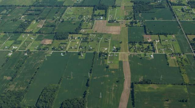
2 PROJECT OVERVIEW Sawmill Parkway Identified in first County Thoroughfare Plan (1987) Southern Terminus Franklin County line at Sawmill Road Northern Terminus City of Delaware near U.S. 42 Total length = 9.5 miles Southern half built with development from 1999 to 2004 Privately designed, constructed, and funded (mostly) Northern 4.5 miles publicly funded Opens November
3 PROJECT OVERVIEW New 4.5 mile section Four lane divided parkway Limited access Four roundabouts in existing intersections Construction July 2015 to November % locally funded Bonds backed by road and sales tax City of Delaware reimbursement (through TIF) 3


4 PROJECT OVERVIEW Why build Sawmill Parkway? Heavy development pressure in region Extension of trunk sewer and new treatment plant serving the corridor Inadequate capacity of existing road system Need to acquire right of way to protect corridor from impending large lot development Economic development analysis 4
5 PROJECT INITIATION Project Team Delaware County Engineer s Office Burgess & Niple, Inc.(B&N) planning and engineering MSi (now MKSK) planning, landscaping Cochran Group Inc. communications Hardlines Design Company (now Commonwealth Heritage Group) archaeological and historic architecture studies M.A.N. Mapping Services aerial mapping CTL Engineering, Inc. geotechnical engineering 5
6 PROJECT INITIATION Feasibility study begins Early 2004 Delaware County Thoroughfare Plan Why the plan was done Why Sawmill Parkway was initiated Managing public involvement biggest challenge 6
 2.")

7 PROJECT INITIATION Support and Advisory Groups 1. Steering Committee (the project team) 2. Advisory Council Steering committee Local government officials representing County, City of Delaware, Concord and Liberty Townships 3. Stakeholder Group Advisory Council Area residents Business representatives School representatives ODOT 7
8 PROJECT INITIATION Opinion Leader Interviews (August 2003 to May 2004) Seeking input: Advantages/disadvantages of project Overall transportation problems in area Information needs Possible resources 32 elected and appointed officials, regional planners, residents What was heard Government officials supported project to relieve traffic congestion and manage future growth Residents were skeptical of the need for a new road 8
9 PROJECT INITIATION Initial Open House June 29, mailings to property owners, news release, posters 120 people attended What was presented The study area Aerial mapping showing changes in the study area from 1999 to 2004 Natural and environmental constraints within study area Subdivisions and rezoned plats within study area Survey 9


10 PROJECT INITIATION Initial Open House June 29, 2004 What was heard 75 surveys completed Majority of people say traffic is moderate to heavy in study area Truck traffic and overall congestion are the biggest transportation issues Mailings were the preferred way of receiving project info o Social media did not exist! Preferred parkway with landscaped or tree lined medians, plus a multi use path 10
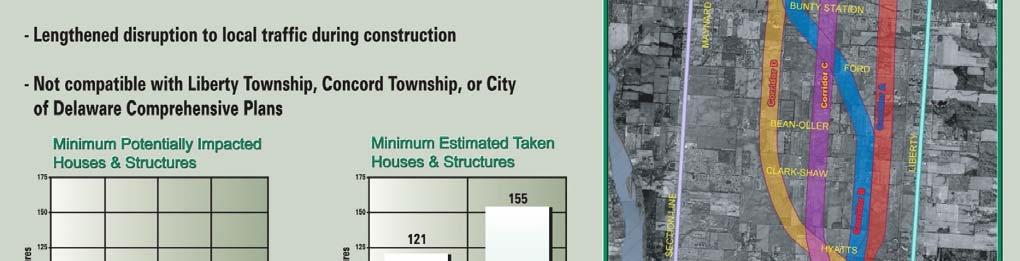
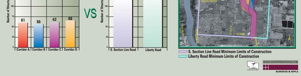
11 PREFERRED CORRIDOR SELECTION PROCESS Second Open House September 29, 2004 Mailings to property owners, news release 221 people attended What was presented Four preliminary study corridors Why not Liberty or South Section Line Road? Survey 11
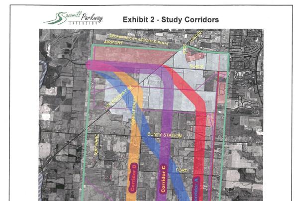
12 12

13 13

14 PREFERRED CORRIDOR SELECTION PROCESS Second Open House September 29, 2004 What was heard Corridors were ranked The majority of respondents (89%) resided in the study area Corridors that impact the least amount of existing homes or structures were favored Fears of reduced property values Many wanted the opportunity to have a question and answer session, in addition to the open house format 14

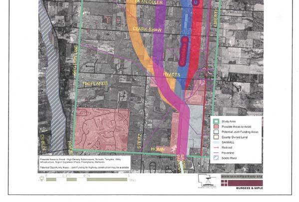
15 PREFERRED CORRIDOR SELECTION PROCESS Corridor Workshop #1 November 1, 2004 Attended by steering committee, some advisory council members, some stakeholders Based on expertise they could bring to the process and/or the interest of whom they represented Goal develop corridor evaluation criteria that have no bias towards any specific corridor By consensus of the workshop participants, the criteria were. 15
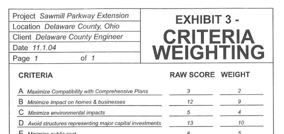
16 PREFERRED CORRIDOR SELECTION PROCESS Corridor Evaluation Criteria (no order of preference or importance) Maximize compatibility with comprehensive plans Minimize impact on existing homes and businesses Minimize environmental impacts Avoid structures representing major capital investments Minimize public cost Recognize public input from surveys Criteria were then compared with each other and rated from 1 (slight or no preference) to 4 (major preference) Raw scores were then tallied and weighted 16
17 17
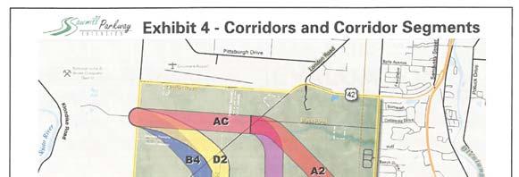
18 PREFERRED CORRIDOR SELECTION PROCESS Corridor Workshop #2 November 5, 2004 Attended by steering committee Goal Evaluate each corridor using the criteria from Workshop #1 Where corridors crossed one another offered different corridor possibilities In all, 13 potential corridor routes were established Three highest scoring routes were determined *Results of Corridor Workshops #1 and #2 were then shared with Advisory Council for input and discussion. 18
19 19
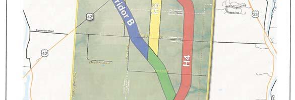
20 20
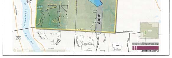
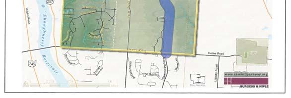
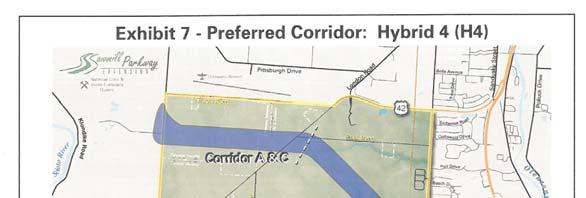
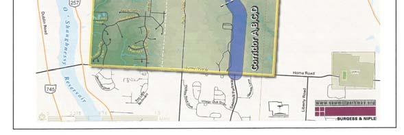
21 PREFERRED CORRIDOR SELECTION PROCESS Advisory Council Meeting November 10, 2004 Comments from Advisory Council Recommended Hybrid Corridor 4 Maximizes available area west of the corridor for single family homes on lot sizes no less than 1 acre Minimizes available area east of the corridor where higher densities might be considered Maximizes available area for development within future limits of City of Delaware *Preferred corridor was announced on November 29,
22 22
23 PREFERRED CORRIDOR SELECTION PROCESS Third Open House January 19, 2005 Mailings to property owners adjacent to or within the preferred corridor, news release 135 people attended Presentation, followed by questions, and then one on one conversations at exhibit stations 23
24 24
25 PREFERRED ALIGNMENT SELECTION PROCESS Fourth Open House March 22, 2005 Mailings to property owners within or adjacent to the feasible alignments, news release 117 people attended What was presented Four feasible alignments within the preferred corridor Survey 25

26 PREFERRED ALIGNMENT SELECTION PROCESS Alignment #1 Alignment #2 Alignment #3 Alignment #4 26
27 PREFERRED ALIGNMENT SELECTION PROCESS Fourth Open House March 22, 2005 What was heard Alignment #4 was the most preferred Lighting only at intersections Bike path should be built on both sides of parkway Earth mounds and trees for screening homes from parkway 27
28 PREFERRED ALIGNMENT SELECTION PROCESS Feasible alignment selection May 9, 2005 B&N staff recommends criteria and weighting for later consideration by the steering committee Preferred corridor selection criteria used as a starting point No additional criteria was recommended Minimizing impacts to homes and businesses, environmental impacts, public cost, and Open House #4 survey results were scored and weighted May 18, 2005 Steering committee meets to evaluate and score the four alternative alignments Alignment #4 received the highest scoring Alignment #4 was then fine tuned to impact fewer parcels of land and to take better advantage of natural drainage patterns *Modified alignment #4 was then presented at the June 28, 2005 Open House as the Preferred Alignment 28
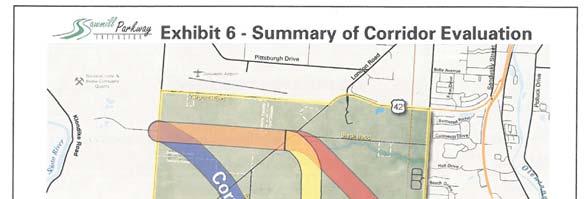
29 PREFERRED ALIGNMENT SELECTION PROCESS Fifth Open House June 28, 2005 Mailings to property owners within or adjacent to the feasible alignments, news release 134 people attended What was presented o Preferred alignment graphic on aerial photography with parcel ownership o Scorecard for alignments o Potential aesthetic enhancements 29


30 30
31 PUBLIC INVOLVEMENT SUMMARY Support and advisory group role Opinion leader interviews Stakeholder involvement (planning and design) Public meetings (five during planning and one during design phase) Stop Sawmill Parkway! Opposition group that surfaced at Open House #2 County made the decision to meet with them and hear their concerns after the meeting Opposition was much reduced by the time the Feasible Alignment was announced Website ( 31


32 SCALABLE PUBLIC INVOLVEMENT APPROACH Process can be used on smaller projects Get public involved before alternatives are developed Meet one on one with property / business owners Have public meetings at decision points and get input for next steps Most people will support a project if they feel they ve been heard City of Green, OH City of Athens, OH 32
33 CONSTRUCTION PLAN DEVELOPMENT Environmental studies and permitting No Federal funds so no ODOT involvement 1 Perennial Stream and 2 Head Water Ephemeral Streams impacted Water impacts approved by USACE with a 404 Nationwide Permit 14, OhioEPA 401 Water Quality Certification No wetland impacts 629 LF (0.26 acres) of stream impacts Mitigation for 830 LF of Streams Conservation Easement for the stream mitigation site will be held by Preservation Parks of Delaware County 33
34 CONSTRUCTION PLAN DEVELOPMENT Access management All properties along the corridor had access to the cross roads. County wanted to limit access to these corridors no direct access to Sawmill Parkway oresulted in some driveway reconfigurations ocare taken to avoid inaccessible land 34


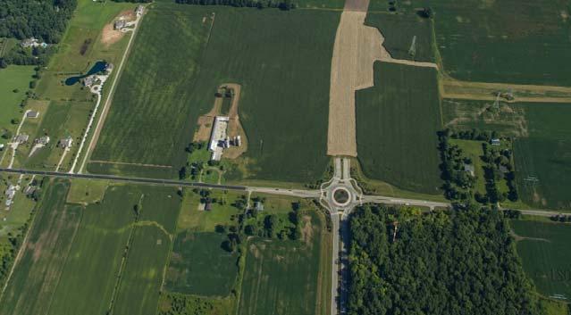
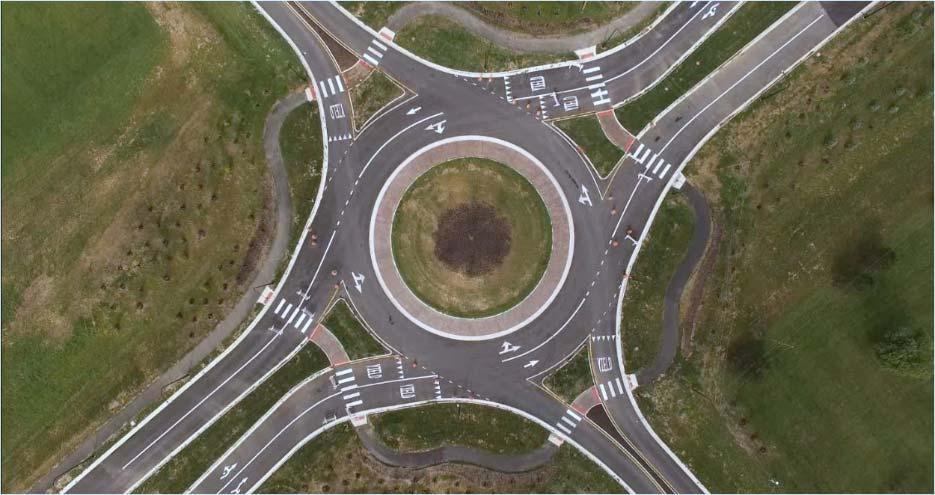
35 CONSTRUCTION PLAN DEVELOPMENT Signals versus Roundabout Public request to investigate Only a few existed in Central Ohio at the time Road trip to Carmel, IN o Similar corridor and worked great Stop controlled warranted at 4 of the 7 intersections opening day Roundabout recommended o Safety benefit o Similar costs Carmel, IN 35
36 CONSTRUCTION PLAN DEVELOPMENT Sixth Open House December 6, 2006 What was presented o Proposed landscaping treatments along length of project o Roundabout informational exhibits o Information on right of way acquisition process What was heard o Overall support for roundabouts and landscaping treatments o Design guidance going forward 36


 Electrical towers")
37 CONSTRUCTION PLAN DEVELOPMENT Design challenges Individual property owner issues o Farm equipment through roundabout o Driveway reconfigurations o Existing ponds o Trees (oldest tree in Delaware County) Electrical towers Drainage design Landscaping 37

 Total R/W acquisition")
38 RIGHT OF WAY ACQUISITION R/W Acquisition Overview 142 R/W parcels acquired, approximately 135 acres Early acquisition of three total take parcels Took 4 years to complete land acquisition Proximity damage to structures and damage to residue parcels was a big issue 24 appropriation cases filed (1 tried) Total R/W acquisition cost: $9.1M 38

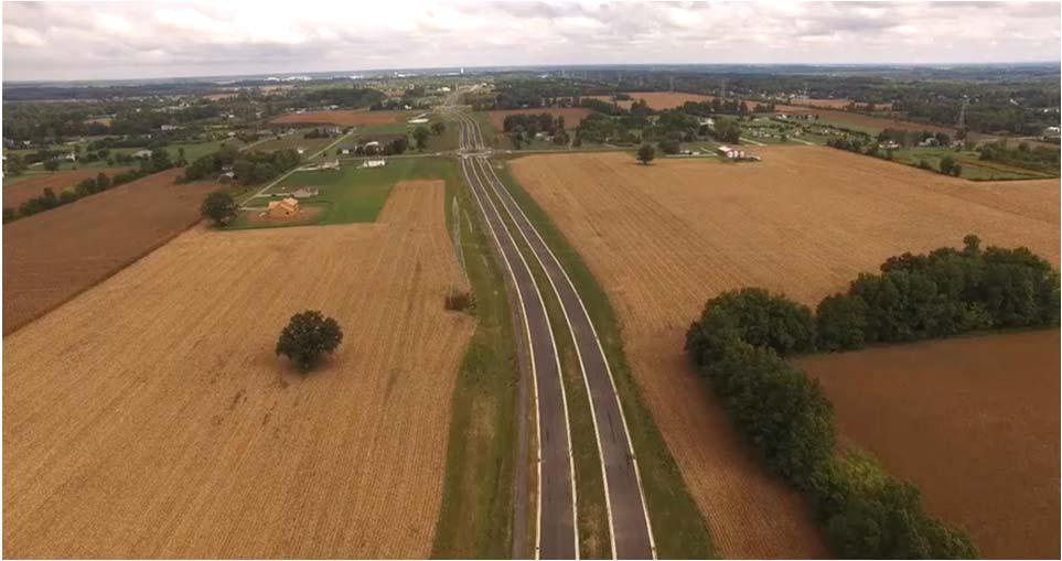
39 BIDDING AND CONSTRUCTION Sales tax bonds issued in May 2015 Engineer's estimate of $37 million Advertised for bids in June bids received ranging from $30.4 to $37.3 million $30.4 million contract awarded to Trucco Construction Groundbreaking ceremony July 23,


40 CONSTRUCTION Utility delays in 2016 delayed roundabout construction by two months and U.S. 42 work by four months Great cooperation with Trucco to get through delays and minimize downtime Opening scheduled for November 10, 2016 Short term closure in Spring 2017 to complete widening at U.S. 42 intersection 40


41 CONSTRUCTION OF SAWMILL PARKWAY 41 Clint Matlack Photography

42 COMPLETION OF SAWMILL PARKWAY Delaware County Engineer Clint Matlack Photography 42

43 POLITICAL OBSTACLES Organized opposition Friends of Delaware County Community Oversight Foundation Project became a campaign issue for County Commissioner candidates Opposition to the use of Imminent Domain Funding challenges City and County cost sharing negotiations 43
44 LESSONS LEARNED Don t underestimate political obstacles Engage project opponents early in the process Engage project champions early in process (and keep them engaged) Control the message be consistent! 44


45 CONTACT US Chris Bauserman, PE, PS, Delaware County Engineer Jeff Griffin, PE, Burgess & Niple, Inc x1306 Brian Moore, PE, Burgess & Niple, Inc x
The Illinois Department of Transportation and Lake County Division of Transportation. Route 173, including the Millburn Bypass
 The Illinois Department of Transportation and Lake County Division of Transportation welcome you to this Public Hearing for U.S. Route 45 from Illinois Route 132 to Illinois Route 173, including the Millburn
PROJECT STATEMENT LOCATION/DESIGN PUBLIC HEARING. 19 th AVENUE NORTH EXTENSION PROJECT FROM SPRINGDALE DRIVE TO NORTH 2 ND STREET/U.S.
 PROJECT STATEMENT LOCATION/DESIGN PUBLIC HEARING 19 th AVENUE NORTH EXTENSION PROJECT FROM SPRINGDALE DRIVE TO NORTH 2 ND STREET/U.S. 67 HEARING LOCATION: ERICKSEN COMMUNITY CENTER 1401 11 TH AVENUE NORTH
SECTION 4(f) DE MINIMIS DOCUMENTATION
 DE MINIMIS DOCUMENTATION") SECTION 4(f) DE MINIMIS DOCUMENTATION Illinois Route 60/83 IL 176 to the intersection of IL 60 (Townline Road) Lake County P-91-084-07 Mundelein Park and Recreation District Project Limit SECTION 4(f)
SECTION 4(f) DE MINIMIS DOCUMENTATION Illinois Route 60/83 IL 176 to the intersection of IL 60 (Townline Road) Lake County P-91-084-07 Mundelein Park and Recreation District Project Limit SECTION 4(f)
Project Overview. Get Involved. Public Information Meeting. Contact Information
 Get Involved VDOT representatives will review and evaluate information received as a result of this meeting. Please fill out the comment sheet provided in this brochure if you have any comments or questions.
Hunt Highway CELESTE PEMBERTON, CFM, CPM PINAL COUNTY CARLOS SANCHEZ SORIA, PE T.Y. LIN INTERNATIONAL
 Hunt Highway CELESTE PEMBERTON, CFM, CPM PINAL COUNTY CARLOS SANCHEZ SORIA, PE T.Y. LIN INTERNATIONAL Agenda Design Concept Report Phase 1 Phase 2 Phase 3 Phase 4 Phase 5 Questions Design Concept Report
Scope of Services. River Oaks Boulevard (SH 183) Corridor Master Plan
 Corridor Master Plan") Scope of Services River Oaks Boulevard (SH 183) Corridor Master Plan PROJECT AREA The project area consists of the River Oaks Boulevard (SH 183) corridor bounded by SH 199 at the northern end and the Trinity
Scope of Services River Oaks Boulevard (SH 183) Corridor Master Plan PROJECT AREA The project area consists of the River Oaks Boulevard (SH 183) corridor bounded by SH 199 at the northern end and the Trinity
Bypass #16 - Bend Parkway (new alignment for US 97) (MP )
 (MP )") Bypass #16 - Bend Parkway (new alignment for US 97) (MP 134.76-141.83) Description: The Parkway is on new alignment for US 97 through Bend. US 97 is a Statewide Highway on the National Highway System that
Bypass #16 - Bend Parkway (new alignment for US 97) (MP 134.76-141.83) Description: The Parkway is on new alignment for US 97 through Bend. US 97 is a Statewide Highway on the National Highway System that
Public Hearing. Charlotte County-Punta Gorda MPO - Meeting Rooms A and B March 14, open house at 4 p.m., formal presentation at 5 p.m.
 Public Hearing Charlotte County-Punta Gorda MPO - Meeting Rooms A and B March 14, 2019 open house at 4 p.m., formal presentation at 5 p.m. Welcome to the Public Hearing for the Harborview Road (CR 776)
Figure 5. Previously Identified Viable Corridors
 OVERVIEW The Central Florida Expressway Authority (CFX) is evaluating the potential to expand SR 408 from its current eastern terminus along SR 50 to SR 520 in northeastern Orange County, Fl. This new
Executive Summary. NY 7 / NY 2 Corridor
 Executive Summary NY 7 / NY 2 Corridor Transportation and Land Use Study December 2005 Prepared for: Town of Colonie Capital District Transportation Committee Prepared by: Introduction: Land use decisions
PRELIMINARY REPORT. HIGHWAY 18 CORRIDOR NEIGHBORHOOD PLAN VILLAGE OF DOUSMAN November, 2014
 PRELIMINARY REPORT HIGHWAY 18 CORRIDOR NEIGHBORHOOD PLAN VILLAGE OF DOUSMAN November, 2014 This preliminary report presents the initial recommendations for land use within the Highway 18 corridor along
SH 199 Corridor Master Plan. Community Meeting No. 2 May 31, 2017
 Community Meeting No. 2 May 31, 2017 Transportation Projects On or Near SH 199 SH 199 from 0.3 miles south of FM 1886 to south end of Lake Worth bridge Construct freeway mainlanes and frontage roads 10-Year
Urban Planning and Land Use
 Urban Planning and Land Use 701 North 7 th Street, Room 423 Phone: (913) 573-5750 Kansas City, Kansas 66101 Fax: (913) 573-5796 Email: planninginfo@wycokck.org www.wycokck.org/planning To: From: City Planning
SCTPO Project Summary September 2014
 A1A MULTIMODAL CORRIDOR PLANNING AND ENGINEERING ANALYSIS Florida Department of Transportation SCTPO Project Summary September 2014 PRESENTATION FOOTER Meeting Agenda What We Plan To Do Project Background
Welcome & Introductions
 Creating a Pedestrian Friendly Street American Public Works Association: 2009 Congress Session 4791 September 16, 2009 Welcome & Introductions Doug Roberts, P.E. Transportation Design Section Manager City
PREPARED FOR: PLATTEVIEW ROAD CORRIDOR STUDY EXECUTIVE SUMMARY
 PREPARED FOR: PLATTEVIEW ROAD CORRIDOR STUDY EXECUTIVE SUMMARY SEPTEMBER 2016 Introduction The Platteview Road Corridor Study was led by the Metropolitan Area Planning Agency (MAPA) with assistance from
Bostwick Road. Municipal Class Environmental Assessment. Public Information Centre #2 June 14, City of London
 Bostwick Road Municipal Class Environmental Assessment Public Information Centre #2 June 14, 2017 Welcome! Welcome to the 2 nd Public Information Centre for the. Representatives from the and the consulting
Iowa s Statewide Urban Design Standards Promote Improved Access Management
 Iowa s Statewide Urban Design Standards Promote Improved Access Management David J. Plazak and Dale S. Harrington Center for Transportation Research and Education Iowa State University 2901 South Loop
Citizen Information Meeting
 Prince William County Government Citizen Information Meeting Vint Hill Road Extension May 11, 2016 Benefits: Route 28 Corridor Improvement Program Estimated significant cost savings versus bidding these
PUBLIC HEARING. Thursday, December 14, 2017 FDOT Urban Office 2198 Edison Avenue Jacksonville, FL 32204
 DISTRICT TWO PUBLIC HEARING I 10 (SR 8) from I 295 to I 95 Project Development & Environment Study Duval County, Florida Financial Project Number 213326 2 22 01 Efficient Transportation Decision Making
5.0 IMPLEMENTATION STRATEGIES
 5.0 IMPLEMENTATION STRATEGIES 5.1 Recommended Alternative This chapter discusses the anticipated steps needed to move each project from recommendation to construction. Since full funding for these alternatives
RFP REQUEST FOR PROPOSALS CITY OF PORTSMOUTH, NH. DESIGN ENGINEERING SERVICES North Mill Pond Trail and Greenway
 RFP 61-18 REQUEST FOR PROPOSALS CITY OF PORTSMOUTH, NH DESIGN ENGINEERING SERVICES North Mill Pond Trail and Greenway Sealed Requests for Proposals, plainly marked RFP 61-18 Design Engineering Services
Secrest Short Cut and Monroe Expressway Small Area Plan AUGUST 29, 2018
 Secrest Short Cut and Monroe Expressway Small Area Plan AUGUST 29, 2018 Background and Process Monroe Expressway will be open by the end of 2018 Union County and Indian Trail identified a need to revisit
Project Overview. Fairfax County Parkway Widening Fairfax County. Get Involved. Public Information Meeting. Contact Information
 Get Involved VDOT representatives will review and evaluate information received as a result of this meeting. Please fill out the comment sheet provided in this brochure if you have any comments or questions.
2017 General Obligation Bond
 2017 General Obligation Bond Presentation of Public and Council Projects to the Transportation & Mobility Stakeholder Committee April 13, 2017 Agenda Deferred Maintenance Project Development Process Projects
Beatties Ford Road & Mt. Holly-Huntersville Road Small Area Plan
 Beatties Ford Road & Mt. Holly-Huntersville Road Small Area Plan Town of Huntersville October 2005 Town of Huntersville Planning Department 101 Huntersville Concord Road Post Office Box 664 Huntersville,
Goals for Tonight s Meeting
 South Anthony Boulevard Railroad Grade Separation Study Report to Community November 30, 2011 Andorfer Commons Theatre Indiana Tech University Goals for Tonight s Meeting Recap of the meeting from last
INDEPENDENCE BOULEVARD AREA PLAN. June 24, 2008
 INDEPENDENCE BOULEVARD AREA PLAN Public Meeting #1 June 24, 2008 Tonight s Agenda Introduction Welcome and Ground Rules Overview Presentation Purpose of the Plan What Brings Us Here? A Tour of the Corridor
BOARD OF SUPERVISORS BUSINESS MEETING ACTION ITEM. Endorsement of Design for Route 7/George Washington Boulevard Overpass. Algonkian and Broad Run
 BOARD OF SUPERVISORS BUSINESS MEETING ACTION ITEM Date of Meeting: March 7, 2017 # 14 SUBJECT: ELECTION DISTRICTS: CRITICAL ACTION DATE: STAFF CONTACTS: Endorsement of Design for Route 7/George Washington
Alternatives Development Three conceptual alternatives were developed for the Race Road/Jessup Village Planning Study and are described below:
 Race Road/Jessup Village Planning Study (H550601) Project Newsletter Spring 2015 Project Description The Study Team, consisting of staff from Anne Arundel County (Department of Public Works and Department
7th Avenue Creek Master Plan Development Project. City of St. Charles, IL. IAFSM CONFERENCE March 14, 2018 MARKET
 7th Avenue Creek Master Plan Development Project MARKET City of St. Charles, IL IAFSM CONFERENCE March 14, 2018 7 TH AVENUE CREEK PROJECT AREA 2 2008 RAIN EVENT 3 RESIDENTIAL STRUCTURE FLOODING COMMERCIAL
Meeting Purpose: Date and Time: Location: Attendance: Handouts:
 Meeting Purpose: Date and Time: Location: Attendance: Handouts: PA Turnpike / I-95 Interchange Project Design Advisory Committee (DAC)/Public Officials Meeting #8 April 12, 2012 at 1:30 p.m. Project Office,
The Village of Sugar Grove, in partnership with Kane County, the Illinois Department of Transportation, and the Illinois Tollway welcomes you to the
 The Village of Sugar Grove, in partnership with Kane County, the Illinois Department of Transportation, and the Illinois Tollway welcomes you to the first Public Meeting for the proposed interchange improvement
Services Department B September 10, 2007
 Report To: Development Services Committee Item: Date of Report: DS-07-246 September 5, 2007 From: Commissioner, Development File: Date of Meeting: Services Department B7200-0001 September 10, 2007 Subject:
Date: April 10, 2017 City Council Work Session April 24, 2017: Status Report on the Comprehensive Plan Update and Transportation Master Plan
 AGENDA REPORT To: From: By: Honorable Mayor and City Council Members Warren Hutmacher, City Manager Sharon Ebert, Director Community Development Date: April 10, 2017 Agenda: City Council Work Session April
Planning Commission Staff Report June 5, 2008
 Owner/Applicant Taylor Village Sacramento Investments Partners, LP c/o Kim Whitney 1792 Tribute Road #270 Sacramento, CA 95815 Staff Recommendation Planning Commission Staff Report Project: File: Request:
US 24 & SR 66 Interchange Modification and Corridor Improvement Project Public Involvement Meeting December 5, 2007
 US 24 & SR 66 Interchange Modification and Corridor Improvement Project Public Involvement Meeting December 5, 2007 Sponsored by: The Ohio Department of Transportation and The City of Defiance Project
Burton Station Village Community Meeting February 26, 2014
 February 26, 2014 SGA Plan Overview Recent announcements by the City of Norfolk regarding the closure of Lake Wright Golf Course and retail development proposals Update on infrastructure improvement plans
PROJECT BACKGROUND. Preliminary Design Scope and Tasks
 PROJECT BACKGROUND Preliminary Design Scope and Tasks The purpose of this Study is the development of preliminary designs for intersection improvements for Trunk Highway (TH) 36 at the intersections of
TOWN OF NEW CASTLE - Master Plan Update
 Our Presentation Today (1) Recap the Master Planning Process To Date (2) Present the Outline of the Master Planning Work Plan (3) Present the Calendar for the Master Plan (4) Outline the scope of a Downtown
CITY OF CHARLOTTESVILLE, VIRGINIA CITY COUNCIL AGENDA
 CITY OF CHARLOTTESVILLE, VIRGINIA CITY COUNCIL AGENDA Agenda Date: December 16, 2013 Action Required: Adoption of Resolution Presenter: Staff Contacts: Title: James E. Tolbert, AICP, Director of NDS James
Longmeadow Parkway Fox River Bridge Corridor. August 6, 2015
 Longmeadow Parkway Fox River Bridge Corridor August 6, 2015 Longmeadow Parkway Bridge Corridor 5.6 miles from Huntley Road to IL 62 Unique municipal/county/state/federal partnership Links Randall Road
OVERMOUNTAIN VICTORY TRAIL BURKE CALDELL CORRIDOR FEASIBLITY STUDY REQUEST FOR QUALIFICATIONS CALDWELL COUNTY PATHWAYS
 OVERMOUNTAIN VICTORY TRAIL BURKE CALDELL CORRIDOR FEASIBLITY STUDY REQUEST FOR QUALIFICATIONS CALDWELL COUNTY PATHWAYS Caldwell County Pathways along with our co-partners City of Lenoir, Town of Gamewell,
WELCOME! 8 8:30 6: TH STREET IMPROVEMENTS. Open House. Presentation & Q&A
 WELCOME! 168 TH STREET IMPROVEMENTS 6:30 Open House 7 8 Presentation & Q&A 8 8:30 Open House WELCOME Todd Pfitzer City of Omaha Engineer Bob Stubbe City of Omaha Public Works Director Jon Meyer Project
TENNESSEE STATE ROUTE 109 CORRIDOR MANAGEMENT AGREEMENT MEMORANDUM OF UNDERSTANDING CORRIDOR MANAGEMENT ALONG STATE ROUTE 109
 TENNESSEE STATE ROUTE 109 CORRIDOR MANAGEMENT AGREEMENT MEMORANDUM OF UNDERSTANDING CORRIDOR MANAGEMENT ALONG STATE ROUTE 109 I. Purpose The purpose of this Agreement is to provide a framework for the
ARGENTA TRAIL (CSAH 28/63) REALIGNMENT SOUTH PROJECT (CP 63-25)
 REALIGNMENT SOUTH PROJECT (CP 63-25)") ARGENTA TRAIL (CSAH 28/63) REALIGNMENT SOUTH PROJECT (CP 63-25) Preliminary Design Report February 2015 Prepared For: City of Inver Grove Heights Dakota County Prepared By: Kimley-Horn and Associates,
ARGENTA TRAIL (CSAH 28/63) REALIGNMENT SOUTH PROJECT (CP 63-25) Preliminary Design Report February 2015 Prepared For: City of Inver Grove Heights Dakota County Prepared By: Kimley-Horn and Associates,
Charles River Skate Park Project
 Charles River Skate Park Project East Cambridge Planning Team Meeting December 12, 2012, 7:00 p.m. 9:00 pm East End House Basement Meeting Room 105 Spring Street, East Cambridge, MA Mission To protect,
City of Toronto. Emery Village Transportation Master Plan
 City of Toronto Emery Village Transportation Master Plan May 2009 Emery Village Transportation Master Plan Toronto, ON May 2009 Consulting Inc. 100 York Blvd., Suite 300 Richmond Hill, ON L4B 1J8 Tel:
North York Centre South Service Road
 North York Centre South Service Road Municipal Class Environmental Assessment Addendum Potential Changes to Doris Avenue, Bonnington Place & Tradewind Avenue Study Summary (June 11, 2015) toronto.ca/nyc-south-road.
BeltLine Corridor Environmental Study
 BeltLine Corridor Environmental Study Joint TAC and SAC Meeting December 8, 2008 What We Will Discuss Today Outreach and Agency Coordination Scoping Results Existing Conditions Historical and Archeological
2 January 13, 2010 Public Hearing APPLICANT: AUTOBELL CAR WASH, INC
 REQUEST: Conditional Use Permit (car wash) 2 January 13, 2010 Public Hearing APPLICANT: AUTOBELL CAR WASH, INC PROPERTY OWNER: MESSER 1060 INDEPENDENCE BOULEVARD STAFF PLANNER: Carolyn A.K. Smith ADDRESS
Request for Statement of Interest in Implementation of the Roosevelt Road Redevelopment Plan
 425 Hillside Avenue Request for Statement of Interest in Implementation of the Roosevelt Road Redevelopment Plan I. INTRODUCTION The is seeking the services of a qualified consulting firm to prepare plans
Chain Bridge Road Sidewalk Improvements Citizen Council Work Session
 Chain Bridge Road Sidewalk Improvements Citizen Council Work Session May 10, 2016 Project Location 2 Project Objectives Provide a continuous pedestrian facility (sidewalk) connection from Downtown City
4/8/2015 Item #10D Page 1
 MEETING DATE: April 8, 2015 PREPARED BY: Christy Villa, Associate Civil Engineer DEPT. DIRECTOR: Glenn Pruim DEPARTMENT: Public Works CITY MANAGER: Larry Watt SUBJECT: NORTH COAST HIGHWAY 101 STREETSCAPE
Expo Light Rail Line. Expo Line Community Meeting Phase 2 Design Update November 2011
 Expo Line Community Meeting Phase 2 Design Update November 2011 Meeting Agenda Phase 2 Design Update Meeting Meeting Purpose and Format Project Status Update Overview of Design Progress Next Steps Open
I. INTRODUCTION. Project Background and Study Area
 I. INTRODUCTION Project Background and Study Area Freedom Parkway is a key east-west corridor connecting I-25 on the west to the Town of Kersey on the east, running approximately one to two miles south
1.0 INTRODUCTION 1.1 TH 14 WEST STUDY AREA Project Description Functional Classification Purpose of the Project
 1.0 INTRODUCTION 1.1 TH 14 WEST STUDY AREA 1.1.1 Project Description The Trunk Highway (TH) 14 West Corridor is a two-lane roadway approximately 22 miles in length. Located in Nicollet County, the corridor
US 95 Phase 2B/5 Open House
 US 95 Phase 2B/5 Open House www.us95nw.com Wednesday, Mountain Crest Community Center 4701 N Durango Drive Las Vegas, NV 89129 Brian Sandoval Governor Rudy Malfabon Director Nevada Department of Transportation
Request for Decision. Recommendation. Presented: Monday, Jul 07, Report Date Friday, Jun 20, Type: Public Hearings
 Presented To: Planning Committee Request for Decision Application for rezoning in order to permit a place of worship on a vacant lot zoned for C1, Local Commercial uses, Cam Street, Sudbury Sitiri Investments
14 October 10, 2012 Public Hearing APPLICANT: MPB, INC
 14 October 10, 2012 Public Hearing APPLICANT: MPB, INC PROPERTY OWNER: MUNDEN & ASSOCIATES, LP STAFF PLANNER: Karen Prochilo REQUEST: Conditional Change of Zoning (AG-1 & AG-2 to Conditional O-2) ADDRESS
SUBJECT: Waterfront Hotel Planning Study Update TO: Planning and Development Committee FROM: Department of City Building. Recommendation: Purpose:
 Page 1 of Report PB-23-18 SUBJECT: Waterfront Hotel Planning Study Update TO: Planning and Development Committee FROM: Department of City Building Report Number: PB-23-18 Wards Affected: 2 File Numbers:
Cottage Grove Road Reconstruction. City of Madison Engineering
 Public Informational Meeting Cottage Grove Road Reconstruction October 8, 2015 Presentation Outline Introduction Project Purpose & Need Proposed Design Overview Environmental Concerns Pedestrian Needs
Gratigny Parkway East Extension Project Development & Environment (PD&E) Study
 Study") Gratigny Parkway East Extension Project Development & Environment (PD&E) Study Session 4: Presentation of Charrette Results December 8, 2010 MDX Work Program #: 92407 ETDM#: 11500 Project Location & Description
Gratigny Parkway East Extension Project Development & Environment (PD&E) Study Session 4: Presentation of Charrette Results December 8, 2010 MDX Work Program #: 92407 ETDM#: 11500 Project Location & Description
Rapid Transit Implementation Working Group
 Rapid Transit Implementation Working Group October 12, 2017 1 Agenda 1. Consultation Update 2. Technical Work Update 3. LTC Rapid Transit Integration 4. Next Steps 2 Consultation Update 3 Consultation
ALMA DRIVE CONSTRUCTION Project Public Meeting June 18, :00 pm
 ALMA DRIVE CONSTRUCTION Project Public Meeting June 18, 2015 6:00 pm Tim Porter, P.E. Program Manager 214.509.4581 tporter@cityofallen.org Angela Mosley, P.E. Project Manager 214.509.4579 amosley@cityofallen.org
ROAD CLOSURE AND LAND USE AMENDMENT SILVER SPRINGS (WARD 1) NORTHEAST OF NOSEHILL DRIVE NW AND SILVER SPRINGS ROAD NW BYLAWS 2C2018 AND 29D2018
 NORTHEAST OF NOSEHILL DRIVE NW AND SILVER SPRINGS ROAD NW BYLAWS 2C2018 AND 29D2018") Page 1 of 19 EXECUTIVE SUMMARY This application proposes redesignating two parcels in the community of Silver Springs from Special Purpose Future Urban Development (S-FUD) District and undesignated road
Page 1 of 19 EXECUTIVE SUMMARY This application proposes redesignating two parcels in the community of Silver Springs from Special Purpose Future Urban Development (S-FUD) District and undesignated road
CAG Meeting #4 Summary
 General Information, Overview, Purpose, and Goals The fourth Community Advisory Group (CAG) meeting for the Sugar Grove Parkway (IL 47) Interchange at the Reagan Memorial Tollway (I-88) Improvement Study
Village of Glenview Plan Commission
 Village of Glenview Plan Commission STAFF REPORT January 22, 2019 TO: Chairman and Plan Commissioners CASE #: P2018-047 FROM: Community Development Department CASE MANAGER: Tony Repp, Senior Planner SUBJECT:
8 February 9, 2011 Public Hearing APPLICANT: 7-ELEVEN, INC.
 . 8 February 9, 2011 Public Hearing APPLICANT: REQUEST: Conditional Use Permit for an automobile service station with a convenience store ADDRESS / DESCRIPTION: 2448 Nimmo Parkway PROPERTY OWNER: COURTHOUSE
Lone Oak Road/ 70 th Street West. Efficient, Effective, Responsive. Preliminary Design Services (CP 26-54)
") (CP 26-54) Dakota County Board of Commissioners September 12, 2017 Purpose of Request Award Design Contract to Kimley-Horn and Associates Approve Joint Powers Agreements with the Cities of Eagan and Inver
(CP 26-54) Dakota County Board of Commissioners September 12, 2017 Purpose of Request Award Design Contract to Kimley-Horn and Associates Approve Joint Powers Agreements with the Cities of Eagan and Inver
Land Use Policy & Development Ordinance Update
 Land Use Policy & Development Ordinance Update Charlotte Chamber of Commerce, Land Use Committee July 27, 2016 Land Use Policy & Development Ordinance Update Land Use Policy & Development Ordinance Update
December 1, 2014 (revised) Preliminary Report -- Thomas Jefferson Site Evaluation
 Preliminary Report -- Thomas Jefferson Site Evaluation") December 1, 2014 (revised) TO: FROM: RE Arlington County Board Thomas Jefferson Site Evaluation Working Group by Carrie Johnson, Chair Preliminary Report -- Thomas Jefferson Site Evaluation The Thomas
December 1, 2014 (revised) TO: FROM: RE Arlington County Board Thomas Jefferson Site Evaluation Working Group by Carrie Johnson, Chair Preliminary Report -- Thomas Jefferson Site Evaluation The Thomas
TIRZ 17/Redevelopment Authority Capital Improvements Plan Projects
 Gessner Widening: T-1701 What: Widen the road from a six-lane divided boulevard to an eight-lane divided boulevard street section, increase turn lanes, update traffic signal system, improve drainage by
Midtown Corridor Alternatives Analysis. Appendix A - Initially Considered Alternatives Screening
 Midtown Corridor Alternatives Analysis Appendix A - Initially Considered Alternatives Screening Arterial BRT on Lake Street - Overall Rating: RATING Metropolitan Council recommendations stated in the Transportation
NASSAU COUNTY TOWN HALL NEW YORK & CONNECTICUT SUSTAINABLE COMMUNITIES. A Unique Bi-State Partnership to Improve Jobs, Housing and Transportation
 NASSAU COUNTY TOWN HALL NEW YORK & CONNECTICUT SUSTAINABLE COMMUNITIES A Unique Bi-State Partnership to Improve Jobs, Housing and Transportation Police Headquarters Auditorium Mineola, NY December 9 th,
AGENDA ITEM: IOWA. west] that were not FISCAL IMPACT. the City of Clive. STAFF REVIEW. Resolution II. Amendment PREPARED BY: REVIEWED BY:
![AGENDA ITEM: IOWA. west] that were not FISCAL IMPACT. the City of Clive. STAFF REVIEW. Resolution II. Amendment PREPARED BY: REVIEWED BY:](/thumbs/93/112428810.jpg "AGENDA ITEM: IOWA. west] that were not FISCAL IMPACT. the City of Clive. STAFF REVIEW. Resolution II. Amendment PREPARED BY: REVIEWED BY:") AGENDA ITEM: CITY OF WAUKEE, IOWA CITY COUNCIL MEETING COMMUNICATION MEETING DATE: March 7, 2016 AGENDA ITEM: Consideration of approval of a resolution approving Engineering Services Amendment No. 1 with
AGENDA ITEM: CITY OF WAUKEE, IOWA CITY COUNCIL MEETING COMMUNICATION MEETING DATE: March 7, 2016 AGENDA ITEM: Consideration of approval of a resolution approving Engineering Services Amendment No. 1 with
Background Summary Report
 Background Summary Report May 2014 Submitted by Macaulay Shiomi Howson Ltd. In association with AMEC MMM Group Brook McIlroy Inc. Hemson Consulting Ltd. Table of Contents 1. Introduction... 1 2. Why is
KNOXVILLE/KNOX COUNTY METROPOLITAN PLANNING COMMISSION SUBDIVISION REPORT - CONCEPT/USE ON REVIEW
 KNOXVILLE/KNOX COUNTY METROPOLITAN PLANNING COMMISSION SUBDIVISION REPORT - CONCEPT/USE ON REVIEW FILE #: 10-SF-17-C 10-I-17-UR AGENDA ITEM #: 12 AGENDA DATE: 11/9/2017 POSTPONEMENT(S): 10/12/2017 SUBDIVISION:
Proposed St. Vital Transmission Complex
 Proposed St. Vital Transmission Complex Round 2 Preferred Route for the St. Vital to Letellier Line What is it? Manitoba Hydro is proposing construction of two 230-kilovolt (kv) transmission lines to improve
APPENDIX I PUBLIC MEETING AT PROJECT INCEPTION
 APPENDIX I PUBLIC MEETING AT PROJECT INCEPTION OKLAHOMA DEPARTMENT OF TRANSPORTATION STATE HIGHWAY 10 ENVIRONMENTAL ASSESSMENT (MIAMI, OKLAHOMA) OPEN HOUSE SEPTEMBER 7, 2006 PROJECT OVERVIEW The Oklahoma
ITS Concept Development Activity Descriptions
 ITS Concept Development Activity Descriptions October 2015 Procedures are subject to change without notice. Check the NJDOT website to ensure this is the current version. Table of Contents Concept Development
12 January 12, 2011 Public Hearing APPLICANT: TAILWIND DEVELOPMENT GROUP,LLC PROPERTY OWNER: CITY OF VIRGINIA BEACH
 12 January 12, 2011 Public Hearing APPLICANT: TAILWIND DEVELOPMENT GROUP,LLC PROPERTY OWNER: CITY OF VIRGINIA BEACH STAFF PLANNER: Faith Christie REQUEST: Conditional Change of Zoning (from PD-H1 Planned
Overview of Southwestern Pennsylvania Commission s (SPC) 2040 Long Range Transportation Plan (LRTP)
 2040 Long Range Transportation Plan (LRTP)") Overview of Southwestern Pennsylvania Commission s (SPC) 2040 Long Range Transportation Plan (LRTP) Presented to Pennsylvania Agency Coordination Meeting May 27, 2015 Doug Smith & Ryan Gordon 1 Southwestern
Overview of Southwestern Pennsylvania Commission s (SPC) 2040 Long Range Transportation Plan (LRTP) Presented to Pennsylvania Agency Coordination Meeting May 27, 2015 Doug Smith & Ryan Gordon 1 Southwestern
SUBJECT: GO Station Mobility Hubs Preferred Concepts: Aldershot GO, Burlington GO and Appleby GO. Planning and Development Committee - Public Meeting
 Page 1 of Report PB-76-17 SUBJECT: GO Station Mobility Hubs Preferred Concepts: Aldershot GO, Burlington GO and Appleby GO TO: FROM: Planning and Development Committee - Public Meeting Planning and Building
Mavis Road Class Environmental Assessment
 Mavis Road Class Environmental Assessment Public Information Centre #2 Wednesday November 9, 2016 6:00 to 8:00 p.m. Please sign in and complete a comment sheet Review the displays on your own or join in
Chapter 13: Implementation Plan
 Implementation A. Introduction The Implementation Plan, in table form on the following pages, provides a summary of all the Action Items recommended in Chapters 2 through 12. The table also indicates which
Remi Mendoza City Planning Academy March 13, 2017
 Remi Mendoza City Planning Academy March 13, 2017 1 What is the General Plan? The 2030 General Plan 5-Year Update (2035 General Plan) Questions and Answers 2 Guidebook for development and growth Required
CHAPTER 3 VISION, GOALS, & PLANNING PRINCIPLES. City of Greensburg Comprehensive Plan. Introduction. Vision Statement. Growth Management Goals.
 CHAPTER 3 VISION, GOALS, & PLANNING PRINCIPLES Introduction The Greensburg Comprehensive Plan is intended as a working community document. A combination of long and short-term goals, this document is intended
NACCED/NACo CONFERENCE JULY 10, 2015
 NACCED/NACo CONFERENCE JULY 10, 2015 Regional Growth Framework 2 Regional Growth Framework Regional Priorities Preferred Growth Concept Tools to Support Local Governments 3 Top Priorities for the CONNECT
PLANNING COMMISSION. Agenda Item # 3.
 PLANNING COMMISSION Agenda Item # 3. CASE SUMMARY Conditional District Rezoning Planning Commission February 4, 2015 CD-9-215 Jeff Walton, 341-3260, jeff.walton@wilmingtonnc.gov Staff recommendation CONDITIONAL
Waverley West B Secondary Planning Process. Open House South Pointe School April 25, 2018
 averley est B Secondary Planning Process South Pointe School April 25, 2018 averley est B Secondary planning process open house Please review the boards and provide your feedback. 1 The Role of a Secondary
Laberge Group. Town of Coeymans. Draft Comprehensive Plan. Overview of Planning Process
 Draft : Presentation of Goals & Strategies Laberge Group Benjamin H. Syden, A.I.C.P., E.D.P Director in Charge Nicole Allen, A.I.C.P. Senior Planner Anjali Malhotra Planner Presentation Outline Introductions
REPORT TO: Council FOR: Regular Meeting. PRESENTED: April 1, 2008 FILE: , Byl 1932 & 1936
 DISTRICT OF SQUAMISH REPORT TO: Council FOR: Regular Meeting PRESENTED: April 1, 2008 FILE: 2006-08, Byl 1932 & 1936 DEPARTMENT: Planning Department SUBJECT: First and Second Readings for Bylaws 1932 (rezoning)
WELCOME TO OPEN HOUSE TWO November 28, 2018
 Langstaff Road Weston Road to Highway 7 Class Environmental Assessment Study WELCOME TO OPEN HOUSE TWO November 28, 2018 Please sign in and join our mailing list Study Overview York Region is conducting
Capital Projects in and near Odenton Town Center
 Capital Projects in and near Odenton Town Center Map ID Anne Arundel County Department of Public Works This project provides for the design, right of way acquisition, and construction of approximately
EXECUTIVE SUMMARY. Introduction
 EXECUTIVE SUMMARY Introduction State Route 68 is a designated scenic route that connects the world-renowned Monterey Peninsula to US Highway 101 and the Salinas Valley. SR 68 is a key route for bicycle,
What Primes Look For
 Subs/Partners: What Primes Look For Rodney Holbert Engineers Architects Planners B&N Today Founded in 1912, Columbus, OH 400+ Professional Staff Offices Nationwide Ranked 131st- ENR Top 500 Design Firms
Town of Peru Comprehensive Plan Executive Summary
 Town of Peru Comprehensive Plan Executive Communities that plan grow by choice, not by chance. A plan makes growth thoughtful, understandable, and predictable. A plan shows that a community is managing
Sorted citizen input comments in review of Blount County plans July, August, and September 2007
 Sorted citizen input comments in review of Blount County plans July, August, and September 2007 The following presents sorted citizen input comments from three sessions held in July, August and September
Atlanta BeltLine Corridor Environmental Study. Scoping Meeting August 2008
 Atlanta BeltLine Corridor Environmental Study Scoping Meeting August 2008 What Will We Be Discussing Today? Study Overview - How Did We Get Here? - What Is the Study About? - Who Is Involved? - Where Is