Three Decades of Smart Growth: Arlington s Urban Village
|
|
|
- Marjory Copeland
- 5 years ago
- Views:
Transcription


1 Three Decades of Smart Growth: Arlington s Urban Village An Overview Christopher Zimmerman Arlington County Board January 26, 2006 Arlington, Virginia 3 1

2 Arlington Today Population ~200,000 Jobs >200,000 Housing units >90,000 4 Arlington Today Daytime population is over 260,000 County has over 34 million sq. ft. of private office space 5 2
 Instead of")
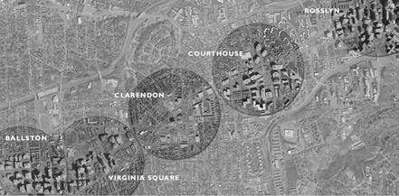
3 Arlington development -- Key role of Metro Transformation into economic center followed introduction of transit in late 70s Development in 2 Metro corridors 7 Transit in Arlington Key decision was re-orientation of Orange line from I-66 to Rosslyn- Ballston corridor Enabled creation of new downtown Urban village, rather than suburban development 8 The R-B Corridor (Orange line) Instead of running on the highway up here the line was sent underground to Ballston 9 3
 Pentagon Pentagon City, Crystal City National Airport")
4 The R-B Corridor (Orange line) 5 stations 24 million sq. ft. of office space -- over 17 since ,500 housing units /2 times as many as in The Jeff Davis Corridor (Blue and Yellow lines) Pentagon Pentagon City, Crystal City National Airport 12 million sq. ft. of Office space 11 Planning Principles Smart growth Density confined largely to R-B and JD corridors -- Of total commercial office (approaching 40 million sq. ft.) 92 % is in the two corridors Maintained low-density neighborhoods outside corridor, preserved green space 12 4
5 5


 Adopted unique designations, specifying higher densities, mixed uses based on development")
6 What Arlington Did Set in motion a series of planning efforts to look at the future of the county The major policy goals that resulted were: Strive for a 50/50 tax base mix of residential and commercial Strive for mixed- use development with a significant level of residential Preserve existing single family and garden apartments Focus redevelopment within 1/4 mile of metro station entrances to encourage transit ridership 16 What Arlington Did 17 What Arlington Did Tools Defined the corridor on the General Land Use Plan (GLUP) Adopted unique designations, specifying higher densities, mixed uses based on development goals 18 6


7 What Arlington Did Tools Then developed sector plans for each Metro station, focused on an area approximately 1/4 mile from the station Give detailed guidance on County expectations for development 19 What Arlington Did Tools 20 What Arlington Did Tools The sector plans identify Desired public improvements Location for retail Urban design standards Public infrastructure needs Open space, streetscape standards They are intended to tell landowners, developers and residents what the future of the station area will be and how individual parcels can be redeveloped 21 7
8 What Arlington Did Tools Aside: The Virginia Context Limitations on local authority Dillon s Rule Property Rights And now back to our show What Arlington Did Tools GLUP, sector plans for Metro corridors indicate County s willingness to rezone for higher density In response to development proposals, county will rezone for higher density use shown on GLUP Lower (pre-existing) zoning remains in place until proposal receives County Board approval of a special exception site plan 23 What Arlington Did Tools The site plan allows significantly higher density & height than underlying zoning ( , 55 ft ft) Site plan is approved only if: It complies with the standards of the zoning ordinance, Is in compliance with the mix required by the GLUP Provides the features called for in the sector plan for the area - including public improvements 24 8
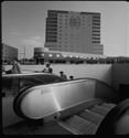
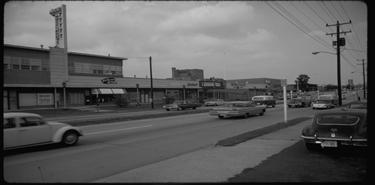
9 What Arlington Did Tools Property owner always maintains underlying byright zoning until they implement approved site plan The zoning categories for site plans actually have lower base rights than the existing zoning Since owner requests rezoning reduced rights is not an issue 25 The Rosslyn-Ballston Corridor Before & After 9


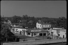

10 ROSSLYN... Then & Now ROSSLYN 29 COURT HOUSE 30 10


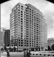
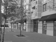
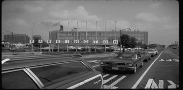


11 CLARENDON Then and Now 31 VIRGINIA SQUARE 32 BALLSTON 33 11
12 Rosslyn Courthouse Clarendon Virginia Square Ballston 34 Lower density Lower density 35 12
13 Assessing Our Success Mixed-use Development People live there: Station areas include more than 30,000 residential units and rising People shop there: 4.6 million sq. ft. of retail (mostly street-level) People work there: Today Arlington has more office space than downtown... Dallas... Pittsburgh... Denver R-B Corridor Development 1970 Office 4,168,033 Residential 6,036 UNITS % Residential to office 36% 2001 Office 19,793,263 Residential 21,813 UNITS % Residential to office 43% 39 13
14 Household, Population & Employment in the R-B Corridor 80,000 70,000 60,000 50,000 40,000 30,000 20,000 10, Est. (Courtesy of Dennis Leach) HH Population Employment 40 Commercial Office and Retail Development in the R-B Corridor Office (M SF) Retail (M SF) UC (Courtesy of Dennis Leach) 41 R-B Corridor Residential and Hotel Development 27,000 24,000 21,000 18,000 15,000 12,000 9,000 6,000 3, UC Hotel Rooms Housing Units (Courtesy of Dennis Leach) 42 14
15 Market Demand Office rents command a premium over suburban locations in the region Office occupancy rates have outperformed most business locations in the last two business cycles Residential demand is very strong across a number of housing types Retail vacancy rates are low and supply is expanding 43 Fiscal Impacts The R-B Corridor produces almost one-third of the County s real estate tax revenue The 7 station sectors in the 2 corridors - constituting one-tenth or less of the County s land area - produce more than half of County tax revenue Arlington enjoys the lowest tax burden in the Washington Metropolitan area 44 TOD Impacts Arlington Metrorail Stations Ridership by Time Period Passengers Thousands Entries Exits 5 0 AM Peak AM Off PM Peak PM Off Time Periods Balanced development -- balanced ridership 45 15
16 Benefits of TOD Getting to work transit use National avg: 4.7 % Fairfax County: 7.3 % Arlington: 23.3% And, those who walk to work are double the national avg, 5 times Fairfax 46 Benefits of TOD Car ownership (vehicles per household) Nationally, almost 90% have a car; 55% have 2 or more In Fairfax, 96% have at least one; two-thirds have 2 or more Arlington: 12% have zero cars; less than 40% have 2 or more 47 Benefits of TOD Numbers are more dramatic in Arlington s Metro corridors Car ownership: 17.9% have zero cars, while less than 25% have 2 or more Getting to work: Less than half drive 39.3% use transit 10.5% walk or bike 2.3 work at home 48 16
17 Metrorail Access at 5 R-B Corridor Stations - 39,500 Daily Boardings 7.5% 3.6% 12.9% 2.0% 1.0% Walk Metrobus Other Bus/Vanpool Auto (incl. Dropoff) Other 73.0% No Response (Courtesy of Dennis Leach) 49 Metrorail Access at 4 Suburban Orange Line Stations - 29,250 Daily Boardings 12.0% 14.6% 1.7% Walk Metrobus 9.3% Other Bus/Vanpool 4.8% Auto (incl. drop-off) Other 57.6% No Response/Unknown 50 (Courtesy of Dennis Leach) Transportation System Performance Despite growth in corridors, and throughout region, traffic growth in corridors has been modest Major increases on the interstates (I-66 and I-395) due to regional and local factors Stable to modest increases of traffic on most arterial streets Stable to modest increases in traffic on residential streets 51 17

")
18 Traffic Trends 25,000 20,000 15,000 10,000 5, Wilson Washington Clarendon Circle N. Wilson Blvd. Highland Key Blvd. Kirkwood Washington Blvd (Courtesy of Dennis Leach) 52 Assessing Our Success EPA First National Award for Smart Growth 53 Assessing Our Success Not to mention -- League of American Bicyclists -- Bicycle Friendly Community designation APTA -- Outstanding Public Transportation System Award (for ART) American Podiatric Association -- Best Walking City in America Sports Illustrated - NRPA -- Sportstown for Virginia 54 18

19 Thank you 56 19
40 Years of Smart Growth Arlington County s Experience with Transit Oriented Development in the Rosslyn-Ballston Metro Corridor
 40 Years of Smart Growth Arlington County s Experience with Transit Oriented Development in the Rosslyn-Ballston Metro Corridor A presentation by the Arlington County Department of Community Planning,
ARLINGTON COUNTY, VIRGINIA
 ARLINGTON COUNTY, VIRGINIA County Board Agenda Item Meeting of March 10, 2012 DATE: February 29, 2012 SUBJECT: SP #197 SITE PLAN AMENDMENT to add a new condition #25 to allow a new use for a Yoga and Pilates
Transportation Working Team Duane Diggs, Co-Chair (VOICE Buffalo) Kelly Dixon, Co-Chair (GBNRTC) Paul Ray, Facilitator (UB Regional Institute)
 Kelly Dixon, Co-Chair (GBNRTC) Paul Ray, Facilitator (UB Regional Institute)") towards a more sustainable Buffalo Niagara Transportation Working Team Duane Diggs, Co-Chair (VOICE Buffalo) Kelly Dixon, Co-Chair (GBNRTC) Paul Ray, Facilitator (UB Regional Institute) Agenda Welcome,
towards a more sustainable Buffalo Niagara Transportation Working Team Duane Diggs, Co-Chair (VOICE Buffalo) Kelly Dixon, Co-Chair (GBNRTC) Paul Ray, Facilitator (UB Regional Institute) Agenda Welcome,
City of Villages Parking Strategies. William Anderson, FAICP City Planning & Community Investment San Diego Parking Symposium July 14, 2006
 City of Villages Parking Strategies William Anderson, FAICP City Planning & Community Investment San Diego Parking Symposium July 14, 2006 City of Villages Strategy A hierarchy of walkable, mixed use districts
The American Legion Post 139 Development Project
 The American Legion Post 139 Development Project SPRC 2 Site Plan #439 3445 Washington Blvd. Arlington, Virginia 22201 December 10, 2018 Proposed Site Uses Create significant new affordable housing 160
DRAFT. Urban Development Areas Fairfax County. UDA Needs Profile: Tysons Corner 13% Location Characteristics. Socio-Economic Characteristics
 14 Urban Development Areas Fairfax County UDA Needs Profile: Tysons Corner Tysons Corner is located in Fairfax County, surrounded by the town of McLean to the east and Vienna on the west along I-495, the
The Village of Shirlington
 The Village of Shirlington Suburban Smart Growth Without Rail Transit July 2018 Agenda History (1940 to present) Attributes and Outcomes Lessons Learned Setting the Stage Arlington County Arlington is
ITEM #8. Regional Smart Growth Program. Regional Smart Growth Program. Presentation Overview. Coast Highway Vision and Stategic Plan.
 Regional Smart Growth Program Economic Development Commission What is Smart Growth? Adopted as part of the Regional Comprehensive Plan (RCP) RCP provides vision for region based on Smart Growth and sustainability
ARLINGTON COUNTY, VIRGINIA
 ARLINGTON COUNTY, VIRGINIA County Board Agenda Item Meeting of September 19, 2015 DATE: September 11, 2015 SUBJECTS: Outdoor Café at Citizen Burger Bar A. SP# 418 Site Plan Amendment to modify an approved
ARLINGTON COUNTY, VIRGINIA
 ARLINGTON COUNTY, VIRGINIA County Board Agenda Item Meeting October 15, 2005 DATE: September 28, 2005 SUBJECT: Request to Advertise the adoption of the 2005 Clarendon Sector Plan C. M. RECOMMENDATION:
ULI PLACEMAKING OBJECTIVES
 ULI PLACEMAKING OBJECTIVES I) What is considered Great Placemaking and why? - Visual examples of New large scale projects with critical mass - Visual examples of Redevelopment smaller scale Main Street
General Land Use Plan (GLUP) Amendments 2001 Present*
 Amendments 2001 Present*") General Land Use Plan (GLUP) Amendments 2001 Present* File # Date Action GP-273-01-1 07/31/01 Approved Low O-A-H Public and Amendment to Note 3 George Mason University Foundation Virginia Square GP-274-01-1
General Land Use Plan (GLUP) Amendments 2001 Present* File # Date Action GP-273-01-1 07/31/01 Approved Low O-A-H Public and Amendment to Note 3 George Mason University Foundation Virginia Square GP-274-01-1
PLANNING IN ARLINGTON. Briefing to Katie Cristol
 1 PLANNING IN ARLINGTON Briefing to Katie Cristol Overview 2 Comprehensive Plan - Background Administration of the Comprehensive Plan Review of the Comprehensive Plan Implementation of the Comprehensive
Silver Line CPAM UPDATE. Transportation and Land Use Committee October 14, 2016
 Silver Line CPAM UPDATE Transportation and Land Use Committee October 14, 2016 Purpose Recap Project History and Map Changes Provide Overview of CPAM Components Discuss Transportation Impacts Discuss Fiscal
LEED-ND 101: Practical Strategies for Achieving Sustainability Goals. Travis Parker Lakewood Planning Director
 LEED-ND 101: Practical Strategies for Achieving Sustainability Goals Travis Parker Lakewood Planning Director Metro Vision Idea Exchange Oct 11, 2012 West Corridor Stations West Corridor Overview West
Reshaping The City: New Visions for Urban Transport. Trent Lethco, Associate Principal Allison Davis, Senior Planner Vicent Risica, Planner Arup
 Reshaping The City: New Visions for Urban Transport Trent Lethco, Associate Principal Allison Davis, Senior Planner Vicent Risica, Planner Arup Agenda Where are we now? Rethinking infrastructure? Cities
General Land Use Plan
 ARLINGTON COUNTY, VIRGINIA Adopted August 12, 1961 with Amendments through December 31, 2017 Residential Residential Public Public Mixed Mixed Use Use Commercial Commercial Office-Apt-Hotel AN ELEMENT
The Re-Emergence of Walkable Urban Places: How the Move Back to Urban Centers is Changing the U.S. Landscape and Economy
 alumni.gwu.edu/webinars The Re-Emergence of Walkable Urban Places: How the Move Back to Urban Centers is Changing the U.S. Landscape and Economy Thank you for joining. The webinar will begin shortly. If
TO: FROM: SUBJECT: Background
 TO: FROM: SUBJECT: Long Range Planning Committee and Zoning Committee of the Planning Commission Kellie Brown and Margaret Rhodes, Planning Division, CPHD DATE: June 8, 2017 Courthouse Square Implementation
ARLINGTON COUNTY, VIRGINIA. County Board Agenda Item Meeting of January 28, 2017 SUPPLEMENTAL REPORT
 ARLINGTON COUNTY, VIRGINIA County Board Agenda Item Meeting of January 28, 2017 SUPPLEMENTAL REPORT DATE: January 26, 2017 SUBJECT: The Virginia Department of Transportation s Transform I-66 Inside the
ARLINGTON COUNTY, VIRGINIA. County Board Agenda Item Meeting of January 28, 2017 SUPPLEMENTAL REPORT-2
 ARLINGTON COUNTY, VIRGINIA County Board Agenda Item Meeting of January 28, 2017 SUPPLEMENTAL REPORT-2 DATE: January 27, 2017 SUBJECT: The Virginia Department of Transportation s Transform I-66 Inside the
Making Transit Oriented Development Work For Boonton, NJ
 Making Transit Oriented Development Work For Boonton, NJ Bloustein School of Planning and Public Policy Studio Dan Burton Loannie Dao Webster Slater Brandon Williams Ian Watson Maria Laham Nicola Mammes
SMART Plan East-West Corridor Land Use Scenario & Visioning Planning
 SMART Plan East-West Corridor Land Use Scenario & Visioning Planning Implementation Plan Charrettes January 2018 Presentation Outline 1. SMART Plan and Land Use Visioning Study Overview 2. Live Polling
August 2016 COTTAGE GROVE STATION AREA PLANNING REPORT
 August 2016 COTTAGE GROVE STATION AREA PLANNING REPORT Introduction The Red Rock Corridor is a proposed 30 mile transitway that runs along Highway 61 and Interstate 94 between Hastings and Union Depot
Friday, March 4, 2011 New Brunswick, NJ
 Friday, March 4, 2011 New Brunswick, NJ Title Sponsors Smart Growth and Redevelopment Learn and Lead 1. Population is changing and redevelopment creates opportunities to meet the new demand Demographic
The Boomburb Downtown. Robert Lang, Ph.D. Arthur C. Nelson, Ph.D. FAICP Metropolitan Institute at Virginia Tech
 The Boomburb Downtown Robert Lang, Ph.D. Arthur C. Nelson, Ph.D. FAICP Metropolitan Institute at Virginia Tech Boomburbs Have over 100,000 residents and are mostly found in the Southwest U.S. Are not the
Rosslyn Sector Plan Implementation
 DEPARTMENT OF COMMUNITY PLANNING, HOUSING AND DEVELOPMENT Planning Division #1 Courthouse Plaza, 2100 Clarendon Boulevard, Suite 700 Arlington, VA 22201 TEL 703.228.3525 FAX 703.228.3543 www.arlingtonva.us
The Need to Develop a Transit Ready Community
 Evaluation & Appraisal Report (EAR) Major Issue # 6 The Need to Develop a Transit Ready Community July 3, 2007 EAR Major Issue # 6 Transit Ready Existing Comp Plan policies apply only to Indiantown Road:
New Town Mixed Use District
 New Town Mixed Use District Montgomery County Planning Commission 2009 Annual Conference PA Chapter of the American Planning Association October 6, 2009 What is NTMU? More urban style of development Complementary
Sustainable Strategies for School Development in Urbanizing Areas
 Sustainable Strategies for School Development in Urbanizing Areas A1 A2 A Corridor School as a part of a mixed- use development in Arlington VA PRECEDENT ANALYSIS Elementary Schools in different contexts
Joint Meeting City Council and the Plan Commission. September 1st, 2015
 Joint Meeting City Council and the Plan Commission September 1st, 2015 1 The City Plan Commission shall recommend a City Plan for the physical development of the City Article IX Section 2 of the City of
SP # Carlin Springs Road The Springs
 SP #430 4318 Carlin Springs Road The Springs SPRC #1 July 29, 2013 Site Site 2 Proposal GLUP change From Low-Medium Residential to High-Medium Residential Mixed-Use Rezoning From RA8-18 to R-C Site Plan
TOWN OF NEW CASTLE - Master Plan Update
 Our Presentation Today (1) Recap the Master Planning Process To Date (2) Present the Outline of the Master Planning Work Plan (3) Present the Calendar for the Master Plan (4) Outline the scope of a Downtown
Principles of TOD: Just the Basics
 Principles of TOD: Just the Basics GB Arrington arrington@pbworld.com Mission Bay TOD, San Francisco, CA 1. Transit-Oriented Development T O D P O D D O T 2. Pedestrian- Oriented Development 3. Development-
Courthouse Square Implementation Comment/Response Matrix
 Courthouse Square Implementation /Response Matrix 1 Are open space symbols binding? GLUP No, open space symbols are not binding, as the GLUP is a policy instrument illustrating the County s future vision
Chapter 1.0 Introduction
 Chapter 1.0 Introduction 1.1 Background The North Metro commuter rail line is part of the RTD FasTracks regional transit system expansion program to build more than 100 miles of rail transit throughout
Rail~Volution October 2008
 Rail~Volution October 2008 1 Where is Tysons Corner? 2 Tysons Corner, Virginia The original edge city Equivalent of 12 th largest US downtown Sprawl on steroids 46m sq ft development 120,000 jobs Additional
Fire Station Location Study
 Fire Station Location Study Presentation to the County Board June, 2014 Jim Schwartz, Chief Fire Station Location Study Fire Stations are located as part of a system that strives to deliver a uniform level
Eastern Gateway / 7 Corners. City of Falls Church & Fairfax County May 14, 2013
 Eastern Gateway / 7 Corners City of Falls Church & Fairfax County May 14, 2013 Eastern Gateway Concept Plan Current Conditions Vision & Goals Building Potential Transportation Circulator to East Falls
Strategic plan framework Steering Committee Meeting
 Strategic plan framework Steering Committee Meeting September 26, 2018 1 agenda 1 Welcome and Strategic Planning introductions Process Strategic Analyses Plan Framework 2 3 Brand Brand Development Naming
TOD 101 CREATING LIVABLE COMMUNITIES WITH TRANSIT
 1 CREATING LIVABLE COMMUNITIES WITH TRANSIT What are transit Centered Communities? Benefits of Partnerships to Support and Implement What You Will Learn Portland s Pearl District Your Trainers Today Catherine
Downtown Elkton Station Area Plan, Elkton, MD. Difficult enough to get support for new starts challenge to fund Houston transit
 Difficult enough to get support for new starts challenge to fund Houston transit More difficult to build Community Support for dense development at station areas Major Concerns: Traffic, Property values,
Kensington Center. Public Meeting # Transit-Oriented Development, Town of Berlin, CT
 Kensington Center Public Meeting #1 10.27.16 Transit-Oriented Development, Town of Berlin, CT CivicMoxie 2016 What is Transit-Oriented Development Definition: Transit-Oriented Development (TOD) = is an
ARLINGTON COUNTY, VIRGINIA
 ARLINGTON COUNTY, VIRGINIA County Board Agenda Item Meeting of July 21, 2012 DATE: July 12, 2012 SUBJECT: SP #416 SITE PLAN AMENDMENT to modify condition #6 to eliminate requirement to provide a pedestrian
TRANSIT ORIENTED DEVELOPMENT PINELLAS COUNTY MPO LIVABLE COMMUNITIES INITIATIVE PINELLAS COUNTY COMPREHENSIVE PLAN AMENDMENTS
 PINELLAS COUNTY MPO LIVABLE COMMUNITIES INITIATIVE MODEL LAND DEVELOPMENT CODE TRANSIT ORIENTED DEVELOPMENT PINELLAS COUNTY COMPREHENSIVE PLAN AMENDMENTS MPO Livable Communities Initiative Goal: Improve
DELIVERING ON THE TRANSIT PROMISE
 DELIVERING ON THE TRANSIT PROMISE Dena Belzer October 6, 2015 Presentation Overview 1. Puget Sound As a Transit Region: Putting SeaTac in Context 2. Starting at the Beginning: How Does TOD Work? 3. Strategies
Urban Planning and Land Use
 Urban Planning and Land Use 701 North 7 th Street, Room 423 Phone: (913) 573-5750 Kansas City, Kansas 66101 Fax: (913) 573-5796 Email: planninginfo@wycokck.org www.wycokck.org/planning To: From: City Planning
Tyvola & Archdale Transit Station Area Plan. June 5, 2008
 Tyvola & Archdale Transit Station Area Plan Second Public Meeting June 5, 2008 Presentation Outline 1. Purpose and Process 2. Station Area Overview 3. Plan Recommendations 4. Comments Received and Proposed
July 23, 2014 Wilson School. Working Group Meeting #3 Preliminary Site Analysis School Siting Considerations Guiding Principles
 July 23, 2014 Wilson School Working Group Meeting #3 Preliminary Site Analysis School Siting Considerations Guiding Principles Agenda Follow-Up from Meeting #2: WG & community feedback Presentations /
Appendix I ARLINGTON COUNTY SECTOR PLANS SUMMARY RECOMMENDATIONS RELATED TO PUBLIC SPACES
 Appendix I ARLINGTON COUNTY SECTOR PLANS SUMMARY RECOMMENDATIONS RELATED TO PUBLIC SPACES The County has developed Sector Plans for various planning areas within Arlington County s Metro corridors. Following
ARLINGTON COUNTY, VIRGINIA
 ARLINGTON COUNTY, VIRGINIA County Board Agenda Item Meeting of April 24, 2004 DATE: April 14, 2004 SUBJECT: Reprinting of the General Land Use Plan C. M. RECOMMENDATION: Approve the reprinting of the General
From: Sent: To: Subject: Zoning: Landscaping:
 From: Bernard H. Berne [mailto:bhberne@yahoo.com] Sent: Tuesday, May 15, 2012 1:18 AM To: CountyBoard Subject: May 19, 2012 County Board Meeting: Goodyear Site Plan (SP #72-650 N. Glebe Road) and amendment
DEPARTMENT OF COMMUNITY PLANNING, HOUSING AND DEVELOPMENT Planning Division. Arlington County Planning Commission
 DEPARTMENT OF COMMUNITY PLANNING, HOUSING AND DEVELOPMENT Planning Division 2100 Clarendon Boulevard, Suite 700 Arlington, VA 22201 TEL 703.228.3525 FAX 703.228.3543 www.arlingtonva.us DRAFT TO: FROM:
SITE PLAN REVIEW COMMITTEE MEETING AGENDA Clarendon Boulevard Conference Room 311 Arlington, VA 22201
 SITE PLAN REVIEW COMMITTEE MEETING AGENDA DATE: Thursday, July 13, 2017 TIME: 7:00 8:30 p.m. PLACE: 2100 Clarendon Boulevard Conference Room 311 Arlington, VA 22201 SPRC STAFF COORDINATOR: TBD Item 1.
The transportation system in a community is an
 7 TRANSPORTATION The transportation system in a community is an important factor contributing to the quality of life of the residents. Without a sound transportation system to bring both goods and patrons
12600 S Existing Conditions
 STUDY AREA BOUNDARY Study Area Boundary Study Area Context The District Riverton Meadows Vista Station Mountain View Village Market Center 2 Mile Radius 12600 S Existing Conditions 12600 S is a river of
Corridors. Re-vitalize our Corridors and Gateways
 Corridors Re-vitalize our Corridors and Gateways Artist s rendering from the 287 Strategic Plan, 2015 Corridors are the major throughways of Loveland but they also provide important commercial, community
MONTGOMERY COUNTY METRO STATION AREA DESIGN CHARRETTE
 MONTGOMERY COUNTY METRO STATION AREA DESIGN CHARRETTE Shady Grove Metro Station Area Charrette Closing Presentation October 25-28, 2000 MONTGOMERY COUNTY, MD M-NCPPC Design Collective, Inc. Architects
Planning for TOD Implementation at a Corridor Scale
 Planning for TOD Implementation at a Corridor Scale Catherine Cox Blair, Reconnecting America Presentation to DRCOG and the Sustainable Communities Initiative May 14, 2012 What is Reconnecting America?
Cherokee. Corporate Headquarters 111 East Hargett Street Suite 300 Raleigh, NC
 Cherokee Corporate Headquarters 111 East Hargett Street Suite 300 Raleigh, NC 27601 919-743-2500 Denver 4600 S. Ulster Street Suite 500 Denver, CO 80237 303-689-1460 London 41-43 Maddox Street London W1S
INDEPENDENCE BOULEVARD AREA PLAN
 INDEPENDENCE BOULEVARD AREA PLAN Public Meeting October 28, 2008 Tonight s Agenda Introduction 4:00 4:05 Tom Warshauer Presentation 4:05 5:00 Blake Drury Group Exercises 5:00 5:50 All Wrap Up & Next Steps
Walkable Urban Places are Different & Complex to Manage
 Walkable Urban Places are Different & Complex to Manage Teaching a NASCAR Driver to be a Fighter Pilot Must Have a Strategy & Be Managed to Succeed, e.g., BID Each New Element Adds Value to Existing Assets
Courthouse Square Planning & Urban Design Study. Courthouse Square Working Group #13 October 15, 2014
 Courthouse Square Planning & Urban Design Study Courthouse Square Working Group #13 October 15, 2014 1 Courthouse Square Process Working Group Community Courthouse Square Advisory Groups & Civic Associations
Planning for TOD Implementation at a Corridor Scale
 Planning for TOD Implementation at a Corridor Scale Bill Sadler, Reconnecting America Presentation to Gold Line Corridor Working Group July 2, 2013 What is Reconnecting America? Reconnecting America is
S I T E P L A N R E V I E W C O M M I T T E E M E E T I N G A G E N D A
 S I T E P L A N R E V I E W C O M M I T T E E M E E T I N G A G E N D A DATE: Monday, March 11, 2019 TIME: 7:00 8:25 p.m. PLACE: 2100 Clarendon Boulevard Lobby Rooms C&D (Cherry & Dogwood) Arlington, VA
CHAPTER 1. Ms. Guajardo s Class - Central Elementary CH 1 1
 INTRODUCTION CHAPTER 1 Ms. Guajardo s Class - Central Elementary CH 1 1 1.1 SETTING South Centre City is a linear corridor south of Downtown Escondido paralleling Centre City Parkway and South Escondido
GOODY CLANCY WITH KITTELSON & ASSOCIATES RHODESIDE & HARWELL FARR ASSOCIATES W-ZHA
 1 1. Welcome 5 min. 2. Follow-up from 9/22 / Corridor of Light, ground floor uses 20 min. 3. Small on-site open spaces / Overview of types, identities 15 min. 4. Rosslyn Plaza Park / Rosslyn Plaza PDSP
Gold Line Bus Rapid Transit Transit Oriented Development (BRTOD) Helmo Station Area Plan
 Helmo Station Area Plan") Appendix F Gold Line Bus Rapid Transit Transit Oriented Development (BRTOD) Helmo Station Area Plan Introduction and Purpose of the Plan The Gold Line Bus Rapid Transit facility is an eleven-mile dedicated
Appendix F Gold Line Bus Rapid Transit Transit Oriented Development (BRTOD) Helmo Station Area Plan Introduction and Purpose of the Plan The Gold Line Bus Rapid Transit facility is an eleven-mile dedicated
M E M O R A N D U M January 6, 2017
 Item #4 M E M O R A N D U M January 6, 2017 To: 2035 Corridor Planning Committee From: Kenneth Baker, Sr. Director of Planning and Development Services Subject: Item #4 Overview Fidelis Purpose: Review
Public Meeting March 10 th 2011
 Public Meeting March 10 th 2011 Agenda 6:00-6:15 6:15-7:00 7:00-8:00 8:00-8:30 8:30-9:00 9:00 Welcome and Introductions Presentation» Project Overview» Recap Existing Conditions / Issues & Opportunities»
12/9/2013. HOLLYWOOD/PINES CORRIDOR PROJECT AMPO 2013 Annual Conference October 24, Our Perspective. Broward.
 HOLLYWOOD/PINES CORRIDOR PROJECT AMPO 2013 Annual Conference October 24, 2013 Our Perspective Broward Fort Lauderdale 1 Broward Metropolitan Planning Organization Fort Lauderdale Fort Lauderdale Skyline
Urban Form Case Studies
 Urban Form Case Studies Elana Horowitz Ontario Growth Secretariat Ministry of Energy and Infrastructure MINISTRY OF ENERGY AND INFRASTRUCTURE 1 Presentation Structure Role of the Ontario Growth Secretariat
A citizen s guide to the. Comprehensive Plan. City of Lakeville, Minnesota 1
 A citizen s guide to the Comprehensive Plan 2008 City of Lakeville, Minnesota 1 Introduction The City of Lakeville completed an update of its Comprehensive Plan in 2008. A comprehensive plan is a tool
Arlington, Virginia is a worldclass
 EXECUTIVE S U M M A RY Arlington maintains a rich variety of stable neighborhoods, quality schools and enlightened land use policies, and received the Environmental Protection Agency s highest award for
Planning Charlotte s Future. Planning Committee June 21, 2016
 Planning Charlotte s Future Planning Committee June 21, 2016 Charlotte s Vision Livable city Vibrant economy Thriving natural environment Diverse population Choices for housing, education, employment Safe
Cobb County Design Guidelines Mableton Parkway & Veterans Memorial Highway Community Design Workshop January 12, 2017
 Community Design Workshop January 12, 2017 Agenda Opening Remarks / Introductions Scope of Work Existing Conditions Key Issues / Opportunities VPS Summary Draft Vision & Goal Statement Implementation Concepts
TOD: The Competitive Advantage
 TOD: The Competitive Advantage Marilee Utter Citiventure Associates Indiana Joint Committee on Mass Transit and Transportation Alternatives October 2007 Transit Building Boom 3,341 existing stations, 27
Blue Line LRT Extension
 v e Noble Pkwy Noble Pkwy Xerxes Ave N Shingle Creek Penn Ave N Penn Ave N Fremont Ave N Lyndale Ave N S Washington Ave University Ave NE Blue Line LRT Extension LIGHT RAIL PLATFORM AND STATION DESIGN
Strategic Growth Area #1 Northampton Boulevard Corridor Area
 Strategic Growth Area #1 Northampton Boulevard Corridor Area Description Strategic Growth Area #1 has established itself as a major employment center in Southside Hampton Roads. Opportunities exist to
Northwest commuter rail station US 36 BRT. Westminster Station
 Northwest commuter rail station Westminster Station US 36 BRT Westminster Center US 36 & Church Ranch Broomfield Flatiron/96 th St. US 36 & McCaslin Table Mesa Boulder Junction 13-month effort that will
S I T E P L A N R E V I E W C O M M I T T E E M E E T I N G A G E N D A
 S I T E P L A N R E V I E W C O M M I T T E E M E E T I N G A G E N D A DATE: Monday, October 30, 2017 TIME: 7:00 8:30 p.m. PLACE: 2100 Clarendon Boulevard Lobby Rooms C&D (Cherry & Dogwood) Arlington,
Tony Garcia, City-County Planning Commission & Beth Alden, Hillsborough MPO
 Tony Garcia, City-County Planning Commission & Beth Alden, Hillsborough MPO TOD Defined A compact neighborhood with housing, jobs and neighborhood services within easy walking distance of a transit station
SOUTH FLORIDA TOD GRANT UPDATE
 Palm Beach Transportation Planning Agency October 2018 SOUTH FLORIDA TOD GRANT UPDATE Presented by Treasure Coast Regional Planning Council in partnership with SFRTA & SFRPC What is Transit Oriented Development
Proposed Comprehensive Plan Strategies DRAFT for discussion June 28, 2017
 Proposed Comprehensive Plan Strategies DRAFT for discussion June 28, 2017 Land Use Rural Areas Refine the Farm and Forest area (FF) Update FF boundaries to account for existing lots less than five acres
Staff Report and Recommendation
 Community Planning and Development Planning Services 201 W. Colfax Ave., Dept. 205 Denver, CO 80202 p: 720.865.2915 f: 720.865.3052 www.denvergov.org/cpd TO: City Council Neighborhoods and Planning Committee
CHAPTER 7: Transportation, Mobility and Circulation
 AGLE AREA COMMUNITY Plan CHAPTER 7 CHAPTER 7: Transportation, Mobility and Circulation Transportation, Mobility and Circulation The purpose of the Transportation, Mobility and Circulation Chapter is to
LEED for Neighborhood Development. A Brief Overview
 LEED for Neighborhood Development A Brief Overview What is LEED ND? LEED for Neighborhood Development First national standard for neighborhood design Developed as a partnership U.S. Green Building Council
Courthouse Square Planning & Urban Design Study Working Group Meeting #11 September 2, 2014
 Courthouse Square Planning & Urban Design Study Working Group Meeting #11 September 2, 2014 1 Study Area Courthouse Square DRAFT Design Concepts A B C 3 Public Feedback July 23 Workshop & Online Survey
City of Long Beach. creating vibrant and exciting places
 City of Long Beach creating vibrant and exciting places Land Use Element Urban Design Element Overview of the two draft General Plan elements Discuss areas of change Economic goals of the plans Case study
Atlanta BeltLine Subarea 3 Master Plan Update
 Atlanta BeltLine Subarea 3 Master Plan Update April 14, 2018 Workshop Meeting 1 22 miles, connecting 45 neighborhoods 22 MILES of transit 46 MILES of streetscapes and complete streets 33 MILES of urban
Rio/29 Future Land Use Alternatives. Rio/29 Small Area Plan Phase 1 December 12, 2016
 Rio/29 Future Land Use Alternatives Rio/29 Small Area Plan Phase 1 December 12, 2016 PRESENTATION OVERVIEW 1 BACKGROUND 2 COMMUNITY INPUT 3 DESIGN PRINCIPLES 4 5 ALTERNATIVES OPEN HOUSE 2 1 PROJECT BACKGROUND
LAND USE OVERVIEW WHAT YOU WILL FIND IN THIS CHAPTER
 LAND USE WHAT YOU WILL FIND IN THIS CHAPTER Information about the City s expected population and employment growth. Description and capacity of existing and future land use designations. Policies that
City of Lake Mary, Florida. Evolution of a Historic Downtown with Transit Oriented Development Strategies
 City of Lake Mary, Florida Evolution of a Historic Downtown with Transit Oriented Development Strategies What is Transit Oriented Development? Walkable villages located at and around transit stations in
Port Lavaca Future Land Use
 Port Lavaca Future Land Use Introduction The City of Port Lavaca is beginning to see sustained growth, after many years of relative stable population. New single family homes, apartments, and businesses
Michigan City Alternative Analysis Realignment Study. Progress Status Update Report Presentation to City Council February 1, 2012
 Michigan City Alternative Analysis Realignment Study Progress Status Update Report Presentation to City Council Project Web Site Project Web Site is Active www. emichigancity.com Click on NICTD logo at
SITE PLAN REVIEW COMMITTEE MEETING AGENDA
 Page 1 SITE PLAN REVIEW COMMITTEE MEETING AGENDA DATE: Monday, January 7, 2019 TIME: 7:00-8:30 p.m. PLACE: Washington-Lee High School Commons, 1301 North Stafford Street Arlington, VA 22201 SPRC STAFF
Executive Summary. NY 7 / NY 2 Corridor
 Executive Summary NY 7 / NY 2 Corridor Transportation and Land Use Study December 2005 Prepared for: Town of Colonie Capital District Transportation Committee Prepared by: Introduction: Land use decisions
City of Welland Commercial Policies. Public Information Centre March 25 th, 2009
 City of Welland Commercial Policies Public Information Centre March 25 th, 2009 Presentation Outline Presentation will address the following four areas: Purpose of this Public Information Centre? Why does
17.11 Establishment of Land Use Districts
 17.11 Establishment of Land Use Districts 17.11.010 Purpose. To promote the health, safety, and general welfare of City residents and those who come to South Salt Lake to work, exchange commerce and recreate.