Planning Districts INTRODUCTION
|
|
|
- Hilary Little
- 5 years ago
- Views:
Transcription
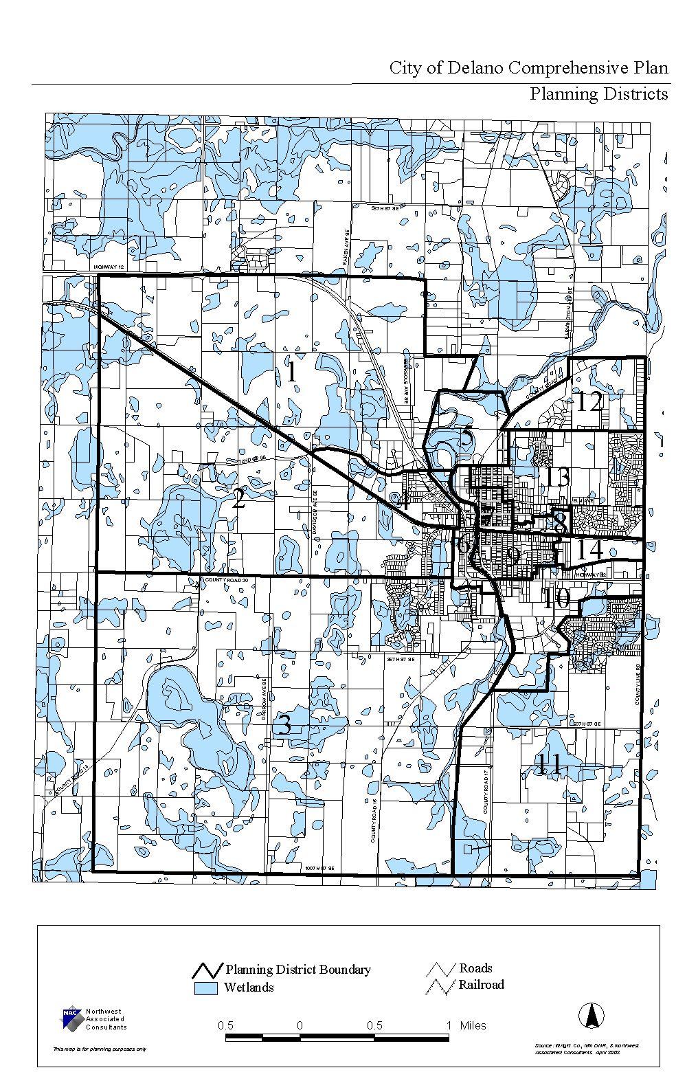
1 INTRODUCTION To facilitate detailed examination of development prospects for all areas of the community, Delano has been divided into 14 planning districts. The location of these planning districts is illustrated on the Extraterritorial Land Use Map within Planning Districts, located on the following page. The planning district boundaries were established mainly using the location of similar land uses and by physical barriers such as highways and water bodies, which naturally separate each from other portions of the City. This section of the Development Framework outlines the land use and development objectives for each individual planning district. 109
2
3 113
4
5 PLANNING DISTRICT 1 - NORTHWEST Planning District 1 is located just north and west of Delano in Franklin Township. This district is bordered by Highway 12 to the north and east and 72 nd Street and the Burlington Northern railroad to the south. The vast majority of this district is guided for industrial use; however, it also contains a small amount of public/semi-public and commercial/industrial land. The recommendations for Planning District 1 are listed below. SUMMARY OF PLANNING DISTRICT 1 RECOMMENDATIONS 1. Work toward annexation of land. Designate area for industrial land use. 2. Work through annexation issues to create a new Delano Industrial Park. 3. Plan for the staged extension of utilities (water and sanitary sewer). 4. Control access points to Highway 12. Industrial park design shall require direct lot access from local streets. 5. Create a buffer yard along Highway 12 to shield the outdoor activities inherent in industrial parks from the view of passing motorists. 6. Pursue the cooperation of private sector developers to promote the development of new industries in Delano. 7. Review and update Delano industrial zoning districts to define the range of uses and site, and to identify building design standards preferred by the City. 8. Industrial park storm water management shall not result in flooding or other drainage problems for adjoining properties. 115
6
7 PLANNING DISTRICT 2 WEST CENTRAL Planning District 2 is located directly west of the City. While a portion of this district lies within the City, most of the district is still located in Franklin Township. The district is bordered by the Burlington Northern railroad to the north, County Road 30 to the south and Highway 12 to the east. The primary land use for this district is low density residential. The district also includes land guided for low/medium density residential, mixed use, and small amounts of public/semi-public and high density. The recommendations for Planning District 2 are outlined below. SUMMARY OF PLANNING DISTRICT 2 RECOMMENDATIONS 1. Enforce the City s Floodplain and Wetland Ordinances to preserve and protect wetlands, floodplains, and drainageways from encroaching development. Secure drainage easements over privately owned wetlands that serve as part of the community s storm water drainage system. 2. Promote property maintenance and yard clean up through City-wide clean up programs and code enforcement. 3. Interconnect new residential neighborhoods and existing neighborhoods with local streets, trails, and shared parks. 4. Expand and enhance park and trail facilities throughout the district. Create neighborhood parks that will serve the new growth areas. 5. Provide safe trail connections from Planning District 2 to commercial destinations along Highway 12 and within the Central Business District. 6. Storm water improvements within the new subdivisions shall be designed to protect adjoining properties and aid in correcting existing drainage problems. 7. Franklin Avenue and 72 nd Avenue shall extend to the west and serve as minor collector streets. 8. Davidson Avenue shall be preserved as a north-south major collector street. 9. District 2 shall be developed with a variety of low to medium density housing styles. 10. County Road 30 shall be designed and preserved as a major collector street. 117
8
9 PLANNING DISTRICT 3 - SOUTHWEST Planning District 3 is located south and west of Delano. Like Planning District 2, a portion of Planning District 3 lies within the City but most of it is in Franklin Township. This district contains several different residential uses and a small amount of commercial land. The higher density residential uses are concentrated along both County Roads 30 and 16. The balance of the district is guided for low-density residential development with the exception of the land in the southeast and southwest quadrants of the County Road 30 and County Road 16 intersection, which are guided for commercial use. The recommendations for Planning District 3 are as follows. SUMMARY OF PLANNING DISTRICT 3 RECOMMENDATIONS 1. Enforce the City s Floodplain, Wetland, and Shoreland Ordinances to preserve and protect wetlands, floodplains, drainageways, and the Crow River from encroaching development. Utilize the aforementioned natural amenities to create a greenway corridor along the Crow River. 2. Utilize the greenway corridor for park and trail facilities that take advantage of the river as a community amenity. 3. Promote high density residential development along County Road 16. Balance residential density with the open space protection along the river. 4. Update City zoning regulations for high density residential development pertaining to density ranges, building design, and required site amenities. 5. Integrate medium density residential uses along major traffic routes. 6. Create a neighborhood commercial zoning district that establishes building and site design standards that will insure compatibility with adjoining residential neighborhoods. 7. Establish a neighborhood park to serve new growth. 119
10
11 PLANNING DISTRICT 4 BUFFALO STREET Planning District 4 is located just west of the Delano. It is bordered by 72 nd Street to the north, Highway 12 to the east, and the Burlington Northern Santa Fe railroad to the south and west. This district includes residential, public/semi-public, and commercial land. The commercial uses are located along Highway 12 while the residential uses are located in the western two-thirds of the district. The district also includes one highdensity residential use. The recommendations for Planning District 4 are listed below. SUMMARY OF PLANNING DISTRICT 4 RECOMMENDATIONS 1. Cooperate with property owners to annex scattered Township parcels within the district and land west of the district. 2. Design future residential expansion in the west part of the district to reduce the visual and land use impacts of the existing commercial and industrial land uses located north of the district (in District 1). 3. Promote low density infill development and redevelopment within the district. 4. Encourage the maintenance and upkeep of residential properties through incentive programs and code enforcement. 5. Plan for the future extension of Buffalo Street north to 72 nd Street as a local urban street. 6. Investigate with Franklin Township the potential improvement of 72 nd Street between Highway 12 and the City s western boundary as an urban street. 7. Work with MnDOT and property owners to address drainage issues along Highway Establish a neighborhood park to serve new growth. 121
12
13 PLANNING DISTRICT 5 CRAMER PARK / DELANO CITY PARK While a portion of Planning District 5 is located within the City, most of it lies within Franklin Township. The portion within the City includes Central Park. The balance of the district is guided for public/semi-public and commercial/industrial uses and lies within the 100 year floodplain of the Crow River. The recommendations for Planning District 5 are outlined below. SUMMARY OF PLANNING DISTRICT 5 RECOMMENDATIONS 1. Maintain and improve both Cramer Park and Delano City Park as recreational focal points for the community. 2. Investigate possible river oriented recreational opportunities. 123
14
15 PLANNING DISTRICT 6 HIGHWAY 12 WEST Planning District 6 runs along either side of Highway 12 between 72 nd Street and County Road 30. The district contains commercial uses and will face major changes as a result of the improvements to Highway 12. The recommendations for Planning District 6 are as follows. SUMMARY OF PLANNING DISTRICT 7 RECOMMENDATIONS 1. Work with MnDOT to implement the in-place redevelopment of Highway 12. Through the Highway 12 improvements, create an attractive entrance to Delano. 2. Create a greenway corridor along the Crow River, taking advantage of right-ofway acquisition for Highway Utilize the Highway 12 upgrade as an impetus for land assembly and redevelopment of marginal commercial sites along Highway Promote economic development and redevelopment through cooperative private and public sector efforts. 5. Phase out non-conforming land uses. 6. Promote site clean up through enforcement of local City codes with special emphasis placed on signs, yard maintenance, and outdoor storage. 7. Enforce the City s Floodplain and Wetland Ordinances and investigate a flood control plan to preserve and protect wetlands, floodplains, and drainageways from encroaching development. 8. Develop pedestrian trails along both sides of Highway Terminate the Franklin Avenue intersection with Highway 12. With MnDOT s cooperation, re-route Franklin Avenue as an access street to serve the commercial sites along the west side of Highway Construct a storm water lift station east of Highway 12 and south of the rail road as a flood protection measure. 125
16
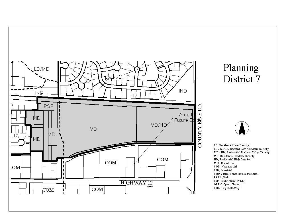
17 PLANNING DISTRICT 7 CENTRAL BUSINESS DISTRICT (CBD) Planning District 7 is the Central Business District for the. It includes a mix of residential, public/semi-public, commercial and industrial uses. The recommendations for Planning District 7 are outlined below. SUMMARY OF PLANNING DISTRICT 7 RECOMMENDATIONS 1. Provide new and enhanced CBD directional signs located along Highway 12. This will provide CBD recognition to the highway motorists. 2. Extend the CBD streetscape improvements (i.e., lighting, sidewalks) west along Bridge Avenue to Highway 12. This will provide an identifiable entrance to the Delano CBD with a continuous design theme. 3. Promote private rehabilitation of buildings in a manner that follows the existing historical architecture theme. Promote exterior building modifications for those buildings that have false facades. 4. Encourage private business expansion, redevelopment, and new business development in the CBD that complement the existing commercial base. To assist in the development and expansion of commercial uses in the CBD, the City has established the CBD study area as a community economic development district to allow the City to participate in redevelopment efforts with public financial assistance and tax increment financing. 5. Promote public acquisition of non-conforming riverside buildings and the creation of a riverside park. This effort is intended to remove non-conforming substandard buildings and to integrate the river as an aesthetic amenity that will complement and enhance the CBD commercial core image. The City should explore DNR floodplain grants to determine their availability in assisting in the financing of the acquisition and demolition of floodway buildings. 6. Consider desired streetscape improvements including pavement, curbing, sidewalks, landscaping, and street lighting. City capital improvements programming and planning offer a means to replace failing infrastructure and enhance the appearance of the CBD commercial core. 7. Promote shared parking within the CBD through the use of public and private lots and on-street parking. 8. Promote the accumulative attraction of the CBD businesses and business interchange among the businesses by: 127
18 a. Establishing common store hours that accommodate the commuter population of Delano. b. Encouraging joint advertising of downtown businesses. c. Establishing of a CBD business directory. d. Continue the City and Chamber of Commerce programs of active community promotion of special events such as Fourth of July celebration and City-wide garage sale. 9. Promote medium and high density residential redevelopment on sites at the periphery of the commercial core to increase local customer base and customer convenience in the CBD area. 10. Continue to allow second story apartments above the commercial buildings as an alternative tenant option and revenue source for the property owner. 11. Promote development of commercial uses that complement existing businesses but do not directly compete with regional retailers. This may require a change in focus from general retail to other businesses including but not limited to specialty retail, restaurants, entertainment, hotel, professional offices, service oriented businesses. 12. Continue to maintain the CBD as the community service focal point of the City. The CBD includes numerous public buildings and services which help provide some identity and attraction to the area. a. Continue to maintain existing City government services in the CBD area including City Hall, Fire Hall, senior citizen center, library, and community center. b. Work with the Delano School District to promote the use and operation of the community education services offered at the Delano Community Education Center. c. Investigate options to keep the Delano post office in the CBD. 13. Pursue the long range redevelopment of the remaining industrial uses in the CBD. 128
19 14. Investigate the extension of Bridge Avenue to 9 th Street as an alternative route to access the CBD to offset the closing of 3 rd Street at Highway Provide trail connections to the CBD. 129
20
21 PLANNING DISTRICT 8 RAILROAD AVENUE Planning District 8 includes all of the industrial land north of the Burlington Northern Santa Fe Railroad between Fourth Street and Parkway in central Delano along with low and medium density residential land. The recommendations for Planning District 8 are listed below. SUMMARY OF PLANNING DISTRICT 8 RECOMMENDATIONS 1. Work with the railroad to upgrade Railroad Avenue to City street standards. Provide for the Railroad Avenue extension to 9 th Street to provide an alternative access to this industrial area. 2. Enforce regulations to promote site clean up in District Promote site redevelopment within District 8 as a means of addressing problem sites. 4. Consider alternative land use options for the northern two-thirds of the Reider site. 131
22
23 PLANNING DISTRICT 9 ST. PETER Planning District 9 is located south of the Burlington Northern Santa Fe Railroad and north and east of Highway 12. This district includes a mix of uses including public/semipublic, institutional, low density residential, and low/medium density. The recommendations for Planning District 9 are as follows. SUMMARY OF PLANNING DISTRICT 9 RECOMMENDATIONS 1. Promote private reinvestment and housing maintenance within the district through zoning flexibility, housing programs, and code enforcement. 2. Consider medium density residential land uses as a redevelopment option for marginal homes within this district. 3. Investigate the extension of St. Peter and Rockford Avenue as a east-west street connection to 9 th Street to provide alternative access points to Highway Examine redevelopment to medium density housing along Rockford Avenue between River and 3 rd Street. 5. Investigate the acquisition and removal of homes in flood hazard areas. 6. Evaluate the property in the southeast corner of St. Peter and 5 th Street for possible medium density development. 133
24
25 PLANNING DISTRICT 10 HIGHWAY 12 EAST Planning District 10 is located in the southern portion of Delano. This district includes the commercial uses along Highway 12 from County Line Road to County Road 17 and the industrial uses along 7 th Street South between Highway 12 and County Road 17. The recommendations for Planning District 10 are listed below. SUMMARY OF PLANNING DISTRICT 10 RECOMMENDATIONS 1. Limit access to Highway Improve the County Road 17/Highway 12 intersection. 3. Develop pedestrian trails along both sides of Highway Promote renovation and/or redevelopment of the Delano East Shopping Center. 5. Encourage the relocation of industrial uses along Highway 12 to the new Delano Industrial Park. Redevelop these sites with compatible commercial uses. 6. Improve Lincoln Drive from County Road 17 to Kelsey Street. 7. Improve 9 th Street between Johnson Drive and Northwood Drive. 8. Realign 7 th Street with 9 th Street to improve access to the industrial park. 9. Encourage the redevelopment of underutilized sites in conformance with the performance standards of the appropriate zoning district. 10. Establish performance standards to address compatibility issues between Maplewood Estates and industrial uses. 11. Promote high quality commercial redevelopment along the Highway 12 corridor. 135
26
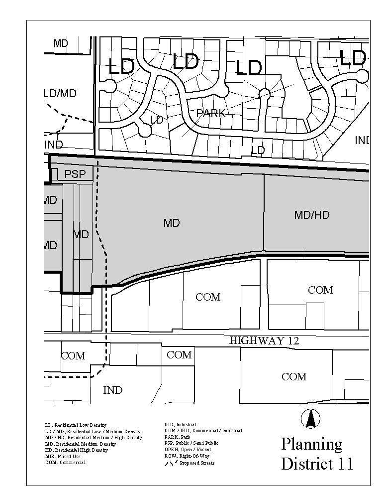
27 PLANNING DISTRICT TH STREET SE Planning District 11 is located south of Delano. While it includes the Woods Creek neighborhood, most of the district lies within Franklin Township. The District extends south from Woods Creek to 100th Street between County Line Road and the Crow River. The recommendations for Planning District 11 are outlined below. SUMMARY OF PLANNING DISTRICT 11 RECOMMENDATIONS 1. Promote the expansion of low density residential development. 2. Integrate residential development with existing environmental features in an effort to protect wetland areas and preserve significant tree cover. 3. Develop a street network that can support future annexation and residential development. 4. Establish neighborhood parks to serve new growth. 137
28
29 PLANNING DISTRICT 12 COUNTY ROAD 17 NORTH Planning District 12 is located in the northeastern corner of Delano. It is bordered by County Line Road to the east, County Road 30 to the south, and County Road 17 to the north and west. All of the land in this district is guided for low-density residential use, with the exception of a small amount of public/semi-public which contains the City s waste water treatment facility. The recommendations for Planning District 12 are as follows. SUMMARY OF PLANNING DISTRICT 12 RECOMMENDATIONS 1. Promote low density residential land uses. 2. Integrate residential development with existing environmental features in an effort to protect wetland areas and preserve significant tree cover. 3. Insure that all future development preserves and protects natural features. 4. Control access from County Roads 17 and
30
31 PLANNING DISTRICT 13 DELANO SCHOOL CAMPUS Planning District 13 is located south of County Road 30 between County Line Road and the Central Business District. This district includes residential uses, the Delano Public Schools campus, and a small amount of commercial, public/semi-public, and industrial uses. The recommendations for Planning District 13 are listed below. SUMMARY OF PLANNING DISTRICT 13 RECOMMENDATIONS 1. Maintain and improve the Delano school campus and play fields. 2. Redevelop the Delano Clinic site. 3. Protect existing wetlands and natural drainage ways, which assist in community storm water drainage through establishment of drainage easements and enforcement of floodplain and wetland protection regulations. 4. Promote low density residential land uses as infill development of existing undeveloped properties. 5. Improve Parkway Avenue by adding a railroad crossing and connection to 9 th Street. 6. Plan for the future extension of Bridge Avenue as an east-west local street between 4 th Street and Parkway Avenue to open existing vacant land for future development. 141
32
33 PLANNING DISTRICT 14 DELANO CROSSINGS RESIDENTIAL Planning District 14 is located south of the Burlington Northern Santa Fe Railroad, north of St. Peter Avenue, and west of County Line Road. The land in this district is primarily guided for medium and high-density residential use, but also contains a small amount of public/semi-public land. The recommendations for Planning District 14 are outlined below. SUMMARY OF PLANNING DISTRICT 14 RECOMMENDATIONS 1. Encourage the development of multiple family housing. 2. Insure that all residential development is served by adequate public facilities. 3. Create pedestrian trails that link the residential and commercial uses in this district with the City s park and recreation system. 4. Establish zoning performance standards that will define the type of multiple family uses that may be acceptable to the City. 143
The transportation system in a community is an
 7 TRANSPORTATION The transportation system in a community is an important factor contributing to the quality of life of the residents. Without a sound transportation system to bring both goods and patrons
DEVELOPMENT FRAMEWORK POST 2030 LAND USE PLAN INTRODUCTION
 INTRODUCTION Oak Grove s Comprehensive Plan identifies a future Metropolitan Urban Service Area (MUSA). The Metropolitan Council does not anticipate extending utilities to this area prior to 2030. The
Plan Policies. Introduction
 Plan Policies Introduction The purpose of the Plan Policies section is to identify the various Governing Body and Planning Commission land use related policy resolutions for use in evaluating development
Olde Towne Vision Plan
 Olde Towne Vision Plan Introduction In 2016, the City of Bellevue will complete its move of City offices from Olde Towne Bellevue to its new municipal complex on Wall Street. The City intends to sell its
CHAPTER 3 VISION, GOALS, & PLANNING PRINCIPLES. City of Greensburg Comprehensive Plan. Introduction. Vision Statement. Growth Management Goals.
 CHAPTER 3 VISION, GOALS, & PLANNING PRINCIPLES Introduction The Greensburg Comprehensive Plan is intended as a working community document. A combination of long and short-term goals, this document is intended
DEVELOPMENT FRAMEWORK 2030 LAND USE PLAN INTRODUCTION
 INTRODUCTION The Oak Grove Land Use Plan anticipates two stages of community development. The first stage of development (28-23) promotes very low density rural growth patterns characterized by large lots,
EXISTING COMPREHENSIVE PLAN
 EXISTING COMPREHENSIVE PLAN Town Center Land Use Element: V. LAND USE POLICIES Town Center Mercer Island's business district vision as described in "Your Mercer Island Citizen-Designed Downtown" was an
EXHIBIT A. Tax Increment Reinvestment Zone No. 1 (Town Center) First Amended Project Plan 1
 First Amended Project Plan 1") EXHIBIT A Tax Increment Reinvestment Zone No. 1 (Town Center) First Amended Project Plan 1 1 As amended by Resolution No. 2008-02-001(TR1R) of the Tax Increment Reinvestment Zone No.1, and approved to
EXHIBIT A Tax Increment Reinvestment Zone No. 1 (Town Center) First Amended Project Plan 1 1 As amended by Resolution No. 2008-02-001(TR1R) of the Tax Increment Reinvestment Zone No.1, and approved to
SECTION II SECTION II STATEMENT OF GOALS, OBJECTIVES, PRINCIPLES, ASSUMPTIONS, POLICIES AND STANDARDS
 STATEMENT OF GOALS, OBJECTIVES, PRINCIPLES, ASSUMPTIONS, POLICIES AND STANDARDS 1 2 STATEMENT OF GOALS, OBJECTIVES, PRINCIPLES, ASSUMPTIONS, POLICIES AND STANDARDS INTRODUCTION The New Jersey Municipal
Table of Contents. Elm Avenue Improvement Plan City of Waco, Texas. Introduction 1. Existing Context 1 Figure 1 2.
 Table of Contents Introduction 1 Existing Context 1 Figure 1 2 Plan Guidelines 3 Future Urban Form 4 The West-End 4 Main Street 6 The East-End 7 Figure 2 9 Public Improvement Recommendations 7 General
124 Subarea Visions. Vision Plan. A. Nelessen Associates, INC I Visioning I Planning I Urban Design
 Subareas 124 Subarea Visions The next seven sections describe specific recommendations tailored to each subarea. Each subarea is discussed separately except for certain aspects of 95th Street and Antioch
2.0 AREA PLANS. Lakeside Business District. Lakeside Business District Land Use Categories:
 Lakeside Business District Lakeside Business District Land Use Categories: Campus Commercial Campus Commercial means a mixture of uses which includes corporate offices, office parks, hotels, commercial,
DRAFT ROOSEVELT ROAD. District Recommendations. Figure 5.23 The Roosevelt Road Corridor
 CHAPTER 5 Figure 5.23 The Road Corridor Road will develop as a mixed-use corridor, emphasizing regional retail, west of the river and mixed-use development east of the river. KEY RECOMMENDATIONS 1. High
Developer s Program. The Station at East 54
 Developer s Program The Station at East 54 Existing Conditions The Station at East 54 is proposed for a 1.12 acre site at the northeast corner of Hamilton Road and Prestwick Road, tucked between the East
Port Lavaca Future Land Use
 Port Lavaca Future Land Use Introduction The City of Port Lavaca is beginning to see sustained growth, after many years of relative stable population. New single family homes, apartments, and businesses
Implementation Guide Comprehensive Plan City of Allen
 Implementation Guide 2030 Comprehensive Plan City of Allen DRAFT 2015 Implementation Guide Allen 2030 Comprehensive Plan INTRODUCTION The Comprehensive Plan serves as a guide for the growth and development
Policies and Code Intent Sections Related to Town Center
 Policies and Code Intent Sections Related to Town Center The Town Center Vision is scattered throughout the Comprehensive Plan, development code and the 1994 Town Center Plan. What follows are sections
NEIGHBORHOOD DESIGN ELEMENT
 NEIGHBORHOOD DESIGN ELEMENT INTRODUCTION The following recommendations constitute an urban design oriented "neighborhood analysis" of Plantation. It is an optional Comprehensive Plan Element. The five
UNIVERSITY OF MICHIGAN:
 Chapter Eight UNIVERSITY OF MICHIGAN: North Campus I. Introduction The University of Michigan currently owns approximately 800 acres of land in the northeast section of Ann Arbor. North Campus refers to
Appendix I-A3 DENAIR COMMUNITY PLAN
 Appendix I-A3 DENAIR COMMUNITY PLAN Adopted by the Stanislaus County Board of Supervisors DECEMBER 15, 1998* *A technical update removing reference to the former Stanislaus County Redevelopment Agency
Hibbing. Land Use. Hibbing Comprehensive Plan 8.1. Land Use
 Hibbing 8.1 Introduction 8.3 Information and Assessment 8.5-8.14 Recommendations 8.15-8.17 Implementation 8.18-8.19 8.2 Introduction Although land use was not identified as a discrete goal during the community
Hockessin Community Redevelopment Plan
 Hockessin Community Redevelopment Plan 3.1 Introduction The Community Redevelopment Plan for the Village of Hockessin is the result of the people s vision for a distinct village center that serves as the
Carlsbad Village Redevelopment Concept Summary of Features
 Carlsbad Village Redevelopment Concept Summary of Features Calthorpe Associates November 5, 2003 The Redevelopment Concept illustrates a vision for the future of Carlsbad Village. The overall vision of
APPENDIX 4 NEWBURY TOWNSHIP TOWN CENTER MASTER PLAN
 APPENDIX 4 NEWBURY TOWNSHIP TOWN CENTER MASTER PLAN Prepared by the Urban Design Center of Northeast Ohio September, 2008 Newbury Township Land Use Plan A4-1 INDEX Page No. 1 Newbury Township Town Center
O l so n M e morial Highway, S t e , G o l d e n V a l l e y, MN Delano Laketown Homes Concept Plan
 N O R T H W E S T A S S O C I A T E D C O N S U L T A N T S, I N C. 4 1 5 0 O l so n M e morial Highway, S t e. 3 2 0, G o l d e n V a l l e y, MN 5 5 4 2 2 T e l e p h o n e : 7 6 3. 9 5 7. 1 1 0 0 W
Land Use. Hardware Street Vendor Mixed-Use
 Land Use Definition Land Use is the way a piece of real estate is utilized. Existing, proposed, and adopted land uses all play a role in the planning process. Once a land use plan is adopted, the next
Volume 2: Implementation Plan
 Volume 2: Implementation Plan February 25 th 2002 Implementation Introduction This document outlines the steps that should be taken to implement the Washington Heights Neighborhood Plan. The City Council
5-Year Street Reconstruction Plan ( )
") 5-Year Street Reconstruction Plan (2006-2010) City of Delano Wenck File #0564-37 Prepared for: CITY OF DELANO 234 2 nd Street West Delano, MN 55328 Prepared by: WENCK ASSOCIATES, INC. 1800 Pioneer Creek
5-Year Street Reconstruction Plan (2006-2010) City of Delano Wenck File #0564-37 Prepared for: CITY OF DELANO 234 2 nd Street West Delano, MN 55328 Prepared by: WENCK ASSOCIATES, INC. 1800 Pioneer Creek
Gold Line Bus Rapid Transit Transit Oriented Development (BRTOD) Helmo Station Area Plan
 Helmo Station Area Plan") Appendix F Gold Line Bus Rapid Transit Transit Oriented Development (BRTOD) Helmo Station Area Plan Introduction and Purpose of the Plan The Gold Line Bus Rapid Transit facility is an eleven-mile dedicated
Appendix F Gold Line Bus Rapid Transit Transit Oriented Development (BRTOD) Helmo Station Area Plan Introduction and Purpose of the Plan The Gold Line Bus Rapid Transit facility is an eleven-mile dedicated
17.11 Establishment of Land Use Districts
 17.11 Establishment of Land Use Districts 17.11.010 Purpose. To promote the health, safety, and general welfare of City residents and those who come to South Salt Lake to work, exchange commerce and recreate.
Asbury Chapel Subdivision Sketch Plan
 Asbury Chapel Subdivision Sketch Plan PART 1: PROJECT SUMMARY Applicant: NVR Inc. Project Size: +/- 76.13 acres Parcel Numbers: 02101112,02116101,02116112, 02116113 Current Zoning: Transitional Residential
PORT WHITBY COMMUNITY
 PORT WHITBY COMMUNITY SECONDARY PLAN UPDATE COMMUNITY IMPROVEMENT PLAN URBAN DESIGN GUIDELINES September 2015 DRAFT PROPOSED AMENDMENT NUMBER # to the Whitby Official Plan PURPOSE: The intent of this Amendment
implementation10 Village of Greendale Comprehensive Plan: Greendale, Wisconsin. Revisiting a Greenbelt Community
 implementation10 Village of Greendale Comprehensive Plan: 2010 - Village of Greendale Comprehensive Plan: 2010 - Implementation The recommendations of this Plan must be implemented by the Village of Greendale,
Northwest Rail Corridor and US 36 BRT Development Oriented Transit Analysis 4.4 STATION AREA FINDINGS
 4.4 STATION AREA FINDINGS Each station is different, and each one requires a separate set of recommendations based on the vision for the site. This section outlines an initial TOD strategy and recommendations
A Plan Enhancement Process for the Future of Howard Design Studio 2 May 28-30, The Howard Plan
 A Plan Enhancement Process for the Future of Howard Design Studio 2 May 28-30, 2011 The Howard Plan West of Pinecrest Future Land Use Plan Velp Corridor Land Use Analysis & Recommendations Duck Creek /Quarry
I-35 CORRIDOR VISION PLAN INTRODUCTION. Purpose. Background
 INTRODUCTION Purpose The Interstate 35-E Corridor Plan is intended to work conjunctively with the 2010 Red Oak Comprehensive Plan to promote positive and quality development and redevelopment along Interstate
Status Update (2006 vs. Now) Citizen s Advisory Committee February Plan for Prosperity
 Citizen s Advisory Committee February Plan for Prosperity") Status Update (2006 vs. Now) Citizen s Advisory Committee February 2018 Plan for Prosperity 2000 2017 2000 2017 Gardnerville Population 6,000 5,760 5746 5,500 5,000 5,067 5,550 5,165 5,394 5,412 5,250
Status Update (2006 vs. Now) Citizen s Advisory Committee February 2018 Plan for Prosperity 2000 2017 2000 2017 Gardnerville Population 6,000 5,760 5746 5,500 5,000 5,067 5,550 5,165 5,394 5,412 5,250
DRAFT. October Wheaton. Design Guidelines
 October 2011 DRAFT Wheaton Design Guidelines 2 Draft - Design Guidelines - Wheaton Sector Plan Contents 04 Section 1: Introduction 06 Section 2: Context 08 Section 3: Design Guidelines 09 Goal 1: Create
Comprehensive Plan Advisory Panel Meeting #3
 Comprehensive Plan Advisory Panel Meeting #3 November 7, 2016 Agenda 1. September 19 th Meeting Notes 2. Summary of Focus Areas Charrette 3. Heart of the City Focus Area a. HOC2/Station Areas Concept &
Town Center. Block 5 Existing multifamily residential units are expected to remain.
 Area Guidelines Germantown s districts should be developed as distinct communities with unique features that are supported through the guidelines. The guidelines not only help distinguish these districts
Planning Area & Context. Planning Goals. 1. Improve circulation and traffic. 2. Increase mutual trust and benefits
 Planning Area & Context Planning Goals 1. Improve circulation and traffic 2. Increase mutual trust and benefits 3. Design integrated streets/ buildings 4. Provide housing and mixed-uses 5. Create and enhance
G. RECREATION AND OPEN SPACE ELEMENT. The following summarizes the Recreation and Open Space Element:
 G. RECREATION AND OPEN SPACE ELEMENT The purpose of the Element is to provide the framework and direction for a comprehensive system of public and private sites for recreation, including, but not limited
3. VISION AND GOALS. Vision Statement. Goals, Objectives and Policies
 Vision Statement Queen Creek s interconnected network of parks, trails, open spaces and recreation opportunities provide safe and diverse activities and programs that sustain its unique, small town, equestrian
Small Area Plan. South Gateway
 Small Area Plan Adopted May 12, 2008 South Gateway Purpose. The South Gateway Small Area Plan defines the City s expectations for the future of the southern entrance to the City at Interstate 85 and Highway
Joint Meeting City Council and the Plan Commission. September 1st, 2015
 Joint Meeting City Council and the Plan Commission September 1st, 2015 1 The City Plan Commission shall recommend a City Plan for the physical development of the City Article IX Section 2 of the City of
Tyvola & Archdale Transit Station Area Plan. May 15, 2008
 Tyvola & Archdale Transit Station Area Plan First Public Meeting May 15, 2008 Presentation Outline 1. Purpose and Process 2. Station Area Overview 3. Plan Recommendations Vision Land Use Transportation
C. Westerly Creek Village & The Montview Corridor
 C. Westerly Creek Village & The VISION Community Vision When the goals of the city are achieved Westerly Creek Village, a distinctive community defined by Montview Boulevard and Westerly Creek, is a strong
Civic Center District
 Civic Center District The Civic Center district is the civic and social heart of Warrenville, containing such public buildings as the City Hall, Warrenville Public Library, Police Station, Park District
SOUTH MAIN RIVER COMMUNITY REINVESTMENT PROJECT AREA PLAN DATED AUGUST 31, 2018
 SOUTH MAIN RIVER COMMUNITY REINVESTMENT PROJECT AREA PLAN DATED AUGUST 31, 2018 Redevelopment Agency of the City of Logan, Utah South Main River Community Reinvestment Project Area - 1 - INTRODUCTION 1.
3 Vision and Goals. Vision and Goals. Blueprint for Bloomsburg. Vision. Town of Bloomsburg Comprehensive Plan,
 Vision and Goals 3 Vision and Goals Citizens of the Town of Bloomsburg clearly value their natural and cultural heritage, the walkable, mixed use pattern of downtown, the access to education, and the community
1.0 Circulation Element
 5/9/18 1.0 Circulation Element 1.1 Introduction As growth and development occur in Apache County, enhancements to its circulation system will be necessary. With time, more roads will be paved and air and
TABLE OF CONTENTS INTRODUCTION PLAN CONCEPT... 3
 TABLE OF CONTENTS BY-LAW NO. Z-1 INTRODUCTION... 1 1.0 PLAN CONCEPT... 3 1.1 Mission... 3 1.2 A Future Vision for Fredericton... 3 1.3 Growth Strategy Goals... 5 National Context... 5 Provincial Context...
ARTICLE 6: Special and Planned Development Districts
 ARTICLE 6: Special and Planned Development Districts 6-10 Traditional Neighborhood Development (TND) District 6-10.10 Purpose and Intent The Traditional Neighborhood Development (TND) District provides
NORTH CENTRAL DISTRICT (Highlands & Centennial Park Neighborhoods)
") City of Highland Park NORTH CENTRAL DISTRICT (Highlands & Centennial Park Neighborhoods) Neighborhood Strategic Plan Approved February 2001 TABLE OF CONTENTS INTRODUCTION...3 Relationship to Master Plan...3
City of Highland Park NORTH CENTRAL DISTRICT (Highlands & Centennial Park Neighborhoods) Neighborhood Strategic Plan Approved February 2001 TABLE OF CONTENTS INTRODUCTION...3 Relationship to Master Plan...3
SECTION TWO: Urban Design Concepts
 SECTION TWO: Urban Design Concepts The Gardnerville Plan for Prosperity shapes economic opportunities presented by regional growth. The Urban Design Concepts provide policies and concepts for land use,
General Location Annex, Rezone & Preliminary Plat Lansdowne Addition, Unit Three
 NEWFOUNDLAND I-5 Agricultural District Subject Site SUNDANCE ANDERSON Single Family Residential CHRISTY PUD Agricultural District Highway Business General Location Annex, Rezone & Preliminary Plat Lansdowne
Definitions. Average Daily Traffic Demand (ADT): The actual number or projected number of cars that pass a point in a 24-hour period.
: The actual number or projected number of cars that pass a point in a 24-hour period.") Definitions Access Management: A combination of physical techniques and transportation policies used to control the flow of traffic between roads and the surrounding lands. Alternative City Form Scenarios:
Definitions Access Management: A combination of physical techniques and transportation policies used to control the flow of traffic between roads and the surrounding lands. Alternative City Form Scenarios:
ESTABLISH AN EFFICIENT TOWN CENTER
 ESTABLISH AN EFFICIENT TOWN CENTER 4 Overview Lisbon residents are proud of the history of Newent and at the same time recognize its current importance as a centralized location for a variety of municipal
Description of Preferred Alternative
 Chapter 2 Description of Preferred Alternative 2.1 Introduction This chapter of the programmatic Sammamish Town Center Sub-area Plan Final EIS provides a more detailed description of the Preferred Alternative
Bourne Downtown Site Planning
 Prepared for: The Town of Bourne, MA In Cooperation with: Bourne Financial Development Corporation Prepared by:, Inc. June 24, 2009 Table of Contents Introduction and Summary... 1 Site Existing Conditions...
CHAPTER 7: Transportation, Mobility and Circulation
 AGLE AREA COMMUNITY Plan CHAPTER 7 CHAPTER 7: Transportation, Mobility and Circulation Transportation, Mobility and Circulation The purpose of the Transportation, Mobility and Circulation Chapter is to
City of Ennis. Downtown Master Plan Catalyst Projects
 City of Ennis Downtown Master Plan Catalyst Projects Revised Framework Plan REVISED Project Types and Descriptions Project Types A. Visitor Attracting Projects: Projects in this category are intended to
Midtown Greenway Land Use and Development Plan Executive Summary
 Midtown Greenway Land Use and Development Plan Executive Summary Introduction The Midtown Greenway Land Use and Development Plan sets policy direction for land use and development in the Midtown Greenway
NORTH COLLEGE PARK. Residential Neighborhood and Neighborhood Center OBJECTIVES EXISTING SITUATION AND ISSUES CONCEPT
 Greenbelt Metro Area Sector Plan - Subarea Design Policies and Guidelines - North College Park 119 NORTH COLLEGE PARK Residential Neighborhood and Neighborhood Center CONCEPT North College Park is envisioned
Elm Fork Land Use. Trinity River Corridor Project Committee May 13, 2013
 Elm Fork Land Use Trinity River Corridor Project Committee May 13, 2013 Purpose Discuss Trinity River planned Land Use and Appropriate Compatible Uses, particularly with respect to the Elm Fork Area 2
Northeast Gateway Revitalization Plan
 Prepared by: Carrie Kruse, Office of Economic Development, 400 Robert D. Ray Drive, Des Moines, IA 50309 Phone: 515/283-4012 Return Address: City Clerk City Hall, 400 Robert D. Ray Drive, Des Moines, IA
Goals and Objectives. Chapter 5 GOALS AND OBJECTIVES. Historic, Cultural, Natural and Agricultural Resources
 Chapter 5 Goals and Objectives Goals are general statements indicating the desired direction for the communities and reflect the long-term state that they wish to establish or to maintain. Objectives are
MALL REVITALIZATION CASE STUDIES
 MALL REVITALIZATION CASE STUDIES DECEMBER 9, 2012 MALL REVITALIZATION OVERVIEW Introduction Sample Case Studies prepared for Lacey Woodland District Steering Committee as it considers strategies to revitalize
CHARLES PUTMAN CHARLES PUTMAN AND ASSOCIATES, INC
 MEMORANDUM CHARLES PUTMAN & ASSOCIATES, INC. LAND DEVELOPMENT CONSULTANTS PLANNING ZONING PERMITTING 4722 NW Boca Raton Boulevard, Suite C-106 Boca Raton, Florida 33431 Phone: 561/994-6411 FAX: 561/994-0447
Vision Statement for the Town of Flower Mound Master Plan The Town of Flower Mound Master Plan furthers the established community based vision to:
 Vision Statement for the The furthers the established community based vision to: Preserve the country atmosphere and natural environment that makes Flower Mound a unique and desirable community; Mitigate
Committee Meeting: Downtown Today & Concept Refinement September 11, 2017
 Committee Meeting: Downtown Today & Concept Refinement September 11, 2017 AGENDA 1. Brief Input Update 2. Comprehensive Plan Principles 3. Downtown Today 4. Concept Updates 5. Future Schedule What is a
ITEM # _ 41 _ DATE: COUNCIL ACTION FORM MAJOR FINAL PLAT FOR MENARDS SUBDIVISION BACKGROUND:
 ITEM # _ 41 _ DATE: 06-12-18 COUNCIL ACTION FORM SUBJECT: MAJOR FINAL PLAT FOR MENARDS SUBDIVISION BACKGROUND: The City s subdivision regulations are included in Chapter 23 of the Ames Municipal Code.
14 October 10, 2012 Public Hearing APPLICANT: MPB, INC
 14 October 10, 2012 Public Hearing APPLICANT: MPB, INC PROPERTY OWNER: MUNDEN & ASSOCIATES, LP STAFF PLANNER: Karen Prochilo REQUEST: Conditional Change of Zoning (AG-1 & AG-2 to Conditional O-2) ADDRESS
Green Infrastructure The Indianapolis Greenways Connection
 Green Infrastructure The Indianapolis Greenways Connection Fewer things in the transportation industry today make better since than combining the needs for pedestrian and bike trails with the need to locate,
DRAFT Civic Center Station Area Plan. Executive Summary
 DRAFT Civic Center Station Area Plan Executive Summary This project is funded in part through the Metropolitan Transportation Commission s Station Area Planning Program. The preparation of this report
Establish a network of streetscaped vehicle and pedestrian routes that connect within and outside the Plan area.
 This Plan s urban design goals are to create an urban scale, walkable community with connections to transit, parks, and services and with amenities and facilities for residents and employees. The 1992
Cornwall Park Neighborhood Plan
 [1] Cornwall Park Neighborhood Plan As adopted by Ordinance No. 8868 and amended by Ordinance Nos. 8946, 9200, 9201, 9233, 9301, 9305, 9749, 9787, 9764, 10502 and 10738, 2000-12-094, 2004-12-087, 2004-12-091,
What Pioneer Grove Will Look Like?
 The City of Deerfield Beach has embarked on a journey to create a new town center within the old heart of Deerfield Beach. The new town center is known as Pioneer Grove. Pioneer Grove will be Everybody
OFFICIAL CONTROLS IMPLEMENTATION LEGAL REQUIREMENTS
 IMPLEMENTATION The objective of the Implementation component of the Comprehensive Plan is to identify the changes that need to be made to the official controls in order to be consistent with the Comprehensive
Land Use. Existing Land Use. Existing Land Use Categories. Faribault Comprehensive Plan 4-1
 Land use patterns play a significant part of defining community identity. The organization of residential, business, and public uses has an influence on how people choose to live, work and play in the
CITY OF COLWICH COMPREHENSIVE PLAN LAND USE LAND USE 1
 LAND USE LAND USE 1 WHAT YOU WILL FIND IN THIS CHAPTER: Discussion of today s conditions and tomorrow s projections Discussion of challenges and opportunities Discussion of the environmental quality goals,
Preliminary Subdivision Plan
 Preliminary Subdivision Plan 704-525-8000 Suite 1200 Executive Summary the east huntersville area development plan provides a series of development initiatives and public improvements for land east of
Warren County/Bowling Green Focus 2030 Comprehensive Plan VOLUME 1 INDEX
 Appendix 5: Index VOLUME 1 INDEX A Aesthetics ES-6, FLU-15, FLU-17, FLU-24, NCR-7 Agricultural Base FLU-18, FLU-20 Agricultural Centers, Rural FLU-11 Agricultural District NCR-17-NCR-18 Agricultural Economy
Complete Neighbourhood Guidelines Review Tool
 Complete Neighbourhood Guidelines Review Tool Prepared By: City of Regina Planning Department October 2014 Page 1 of 14 Community Development Review Checklist for Secondary Plans and Concept Plans The
Town Center (part of the Comprehensive Plan)
") Town Center (part of the Comprehensive Plan) Mercer Island Town Center Looking North (2014) In 1994, a year-long process culminated in a set of design guidelines and code requirements for the Town Center
Town Center (part of the Comprehensive Plan) Mercer Island Town Center Looking North (2014) In 1994, a year-long process culminated in a set of design guidelines and code requirements for the Town Center
THEMES, VISION, + PRINCIPLES
 CHAPTER 2: THEMES, VISION, + PRINCIPLES This page intentionally left blank. 20 VISION DRAFT AUGUST 2018 2 2 THEMES, VISION, + GUIDING PRINCIPLES The Key Themes, Vision, and Guiding Principles presented
KEIZER STATION PLAN INTRODUCTION
 KEIZER STATION PLAN INTRODUCTION Planning for this area began in 1987 when the Keizer Comprehensive Plan established the Chemawa Activity Center and McNary Activity Center. The first Chemawa Activity Center
AGENDA SPECIAL MEETING OF THE AMES CITY COUNCIL COUNCIL CHAMBERS - CITY HALL 515 CLARK AVENUE JUNE 19, 2018
 AGENDA SPECIAL MEETING OF THE AMES CITY COUNCIL COUNCIL CHAMBERS - CITY HALL 515 CLARK AVENUE JUNE 19, 2018 CALL TO ORDER: 6:00 p.m. 1. Second passage of ordinance to change street names in the East Annexation
Parks, Open Space and Trails
 Introduction Parks have often been referred as the lungs of our cities, cleansing the air of pollutants and particulate matter. Parks are also gathering places for families and community. They offer spaces
URBAN DESIGN BRIEF 181 Burloak Drive, Oakville
 URBAN DESIGN BRIEF 181 Burloak Drive, Oakville February 2017 Our File: 1730B 230-7050 WESTON ROAD / WOODBRIDGE / ONTARIO / L4L 8G7 / T: 905 761 5588/ F: 905 761 5589/WWW.MHBCPLAN.COM TABLE OF CONTENTS
A BLUEPRINT FOR BROCKTON A CITY-WIDE COMPREHENSIVE PLAN
 A BLUEPRINT FOR BROCKTON A CITY-WIDE COMPREHENSIVE PLAN Public Meeting October 2016 1 Plan Summary and Discussion Public Meeting May 4 2017 City of Brockton Bill Carpenter, Mayor Department of Planning
Chisholm Community Form
 Chisholm Community Form 1.1 Community Goals 1.3 Information and Assessment 1.5 1.12 Recommendations 1.13 1.22 Implementation 1.23-1.26 1.2 Community Goals Neighborhoods Strengthen the sense of community
THREE-YEAR CAPITAL IMPROVEMENT PLAN FY
 THREE-YEAR CAPITAL IMPROVEMENT PLAN FY2016 2018 Annual CIP Development Process Public Works & Engineering Divisions Prepare List of Capital Needs and Recommended Deferred Maintenance Public Works & Engineering
Corridor Vision. 1Pursue Minnehaha-Hiawatha Community Works Project. Mission of Hennepin County Community Works Program
 1Pursue Minnehaha-Hiawatha Community Works Project Minnehaha-Hiawatha Community Works is a project within the Hennepin Community Works (HCW) program. The mission of the HCW program is to enhance how the
FUTURE DEVELOPMENT AREAS
 FUTURE DEVELOPMENT AREAS Refer to the Future Development Map on Page 2. Suburban Residential (Less than 3 units/acre) Suburban Residential neighborhoods form the backbone of Smyrna. While growth and redevelopment
City of Farmington. Downtown Plan. Amendment to the 1998 Master Plan Adopted October 11, 2004
 City of Farmington Amendment to the 1998 Master Plan Adopted October 11, 2004 Introduction Planning Background 1 Scope and Components of the Plan Amendment 2 Concept Introduction 3 Plan Concepts 3 Conceptual
Prosperity Hucks Area Plan. Transportation and Planning Committee May 11, 2015
 Prosperity Hucks Area Plan Transportation and Planning Committee May 11, 2015 Presentation Outline 1. Background and Location 2. Community Dialog Process 3. Activity Center Recommendations 4. Wedge Recommendations
A P P E N D I X B - O P P O R T U N I T Y S I T E S
 A P P E N D I X B - O P P O R T U N I T Y S I T E S OPPORTUNITY SITES As listed in the Land Use Element, the City has identified 15 Opportunity Sites expected to be the focus of change and revitalization
OP Council Resolution June 16, Planning and Development Services
 OP-08-01 Council Resolution June 16, 2008 Planning and Development Services Kingsgate Landing Outline Plan Table of Contents 1.0 Introduction 1 1.1 Purpose of Plan 1 1.2 Plan Area Location 1 1.3 Ownership
CITY PLANNING COMMISSION AGENDA. ITEM NO(s): C.1 C.3 STAFF: STEVE TUCK
: C.1 C.3 STAFF: STEVE TUCK") Page 34 CITY PLANNING COMMISSION AGENDA ITEM NO(s): C.1 C.3 STAFF: STEVE TUCK FILE NOS: CPC ZC 12-00035 QUASI-JUDICIAL CPC NV 12-00036 QUASI-JUDICIAL AR DP 12-00039 QUASI-JUDICIAL PROJECT: APPLICANT: OWNER:
Page 34 CITY PLANNING COMMISSION AGENDA ITEM NO(s): C.1 C.3 STAFF: STEVE TUCK FILE NOS: CPC ZC 12-00035 QUASI-JUDICIAL CPC NV 12-00036 QUASI-JUDICIAL AR DP 12-00039 QUASI-JUDICIAL PROJECT: APPLICANT: OWNER: