Elevated Water Storage Facility and Pumping Station Municipal Class EA for Pressure District 7: PIC # 1 Summary
|
|
|
- Brent Kristian Briggs
- 5 years ago
- Views:
Transcription

1 Memorandum DATE: March 14, 2018 TO: FROM: CC: OUR REF.#: SUBJECT: Winston Wang, M.A.Sc., P.Eng Project Manager, City of Hamilton Jennifer Whittard, B.E.S., PMP Shelley Kuan, Jessica Mollo WM Elevated Water Storage Facility and Pumping Station Municipal Class EA for Pressure District 7: PIC # 1 Summary The first Public Information Centre (PIC) was held on December 6, 2017 in conjunction with the Elfrida Growth Area Study. The PIC was held from 6:00 to 8:30 pm at the Valley Park Recreation Centre and Arena located at 970 Paramount Drive, Stoney Creek. The PIC followed an informal open house format with large display boards set up around the gymnasium (see Attachment A). The display boards presented the study background, an overview of the Class EA process, study area and alternative sites, proposed evaluation criteria, and next steps. The Elfrida PIC included a formal presentation at 6:30 pm, for which COLE presented a few slides relating to the Class EA (see Attachment B). Attendees were invited to sign-in, review the display boards, ask questions and provide comments. Comment sheets were available for those who wished to provide comments. A copy of the display boards and comment sheet were provided to the City on December 7, 2017 for posting on the City s website; however, it appears that nothing has been posted to date other than contact information for the City s former Project Manager under the Related Studies link at Comments Received A total of 19 people signed through the duration of the PIC (see Attachment C). The majority of attendees were members of the general public, but others included consultants and representatives from the City. Two (2) comment sheets were received including the following comments: Request for a copy of the display boards; and More development. More traffic. Roads and RHV need to be expanded at the same time (no blaming other governments). General discussions were also had with the public and included extending the watermain further east along Rymal Road East and potential impacts to agricultural lands and loss of crops. There were no opposing comments regarding the future elevated water storage facility and pumping station within the area.
2 Attachment A PIC Displays


3 Elevated Water Storage Facility and Pumping Station Study for Pressure District 7 Municipal Class Environmental Assessment Public Information Centre #1 December 6, 2017, 6:00-8:30 pm Valley Park Recreation Centre and Arena (Gymnasium) 970 Paramount Drive Stoney Creek, Hamilton We value your input in the decision-making process. Please fill out a comment sheet or discuss your concerns with one of our study representatives.
4 Study Background The purpose of the Municipal Class Environmental Assessment (EA) is to select the preferred sites for a new elevated water storage facility and pumping station. This new infrastructure is required to provide water supply for future growth within Pressure District 7 (PD7), and to address security of supply and water system balancing. To meet projected population growth, the elevated water storage facility is required by approximately 2021 and the pumping station by 2027.


.")


5 Overview of the Municipal Class EA Process The Ontario Environmental Assessment Act (EAA) requires that most municipal infrastructure projects follow an approved Class EA process. This study is being conducted in accordance with the approved requirements for a Schedule B project as described in the Municipal Engineers Association s Municipal Class EA document. The study is currently in Phase 2: Alternative Solutions. The results of the evaluation the preferred sites for the elevated water storage facility and pumping station will be presented at a second Public Information Centre (PIC). Review agencies and the public will be notified of both the PIC and Project File Report completion, including the mandatory 30-day public review period. Phase 1: Problem or Opportunity Identify the problem(s) or opportunities Phase 2: Alternative Solutions Identify alternative solutions Inventory natural, cultural and socio-economic environments Identify potential impacts of the alternative solutions and mitigation Evaluate the alternative solutions considering environmental and technical impacts Identify a recommended solution Confirm the preferred solution based on input from the PIC and review agencies Project File Report Prepare Project File Report to describe the activities undertaken through Phases 1 and 2 Notify stakeholders of study completion and the Part II Order provision in the EAA Place Project File Report on public record for review for 30- calendar days Implementation Subject to comments received, proceed to detailed design and construction Notice of Study Commencement and Public Information Centre (PIC) Discretionary PIC December 6, 2017 Mandatory PIC (and Notice of PIC) Spring/Summer 2018 Notice of Study Completion

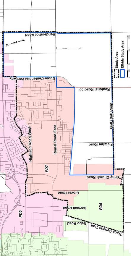
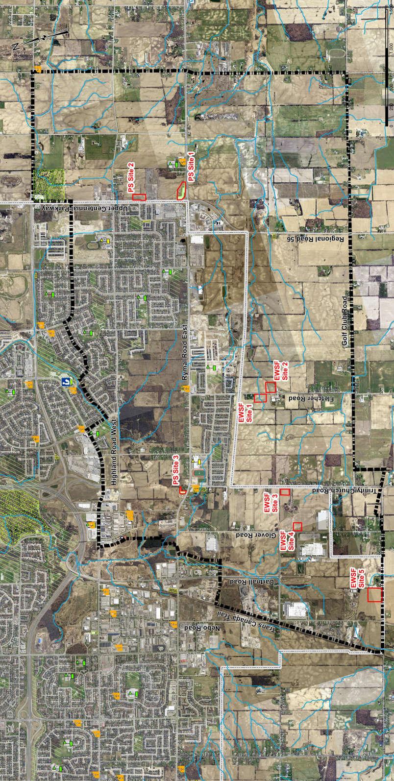
6 Study Area and Alternative Sites Contains public sector data made available under the City of Hamilton s Open Data License.
7 Proposed Evaluation Criteria Component Evaluation Criteria Indicator(s) Natural Environment Natural Heritage Features Water Resources Potential effects on natural heritage features, including Environmentally Significant Areas (ESAs), Areas of Natural and Scientific Interest (ANSIs), wetlands and/or woodlands Potential impacts to ground and surface water features Groundwater management complexity during construction Fauna Potential for displacement of fauna and impacts to Significant Wildlife Habitat (SWH) or Species at Risk (SAR) Social/Cultural Environment Number and relative size/area of natural heritage features disrupted Number and type of watercourse crossings, if applicable Proximity to floodplains and/or regulated areas Potential for short-term water taking during construction Loss or disruption to SWH or SAR Land Use Compatibility with current and future land uses in the area Current and planned future land use Compliance with Official Plans and policies Community Short-term construction related impacts to residents, businesses and the Type and proximity of residential, business and/or community features community, such as the potential for noise, dust, vibration and traffic impacts Archaeology and Cultural Heritage Potential for loss and/or disruption to archaeological and/or cultural heritage resources Archaeological potential Type and proximity of known archaeological and/or cultural heritage resources Property Requirements Technical Considerations Requirement for temporary/permanent easements or property acquisition Ownership Constructability Soil/ground conditions and potential for encountering problems during Constructability given predicted soil/ground conditions construction Ease of access for construction and staging/maintenance operations Sufficiency of space/area to allow for construction access and staging/maintenance operations Operability Ability to provide optimal system reliability and hydraulic performance Location and hydraulics Conflicts Ability to make use of existing infrastructure or coordinate with planned infrastructure improvements Economic/Financial Considerations Existing infrastructure and utilities Coordination opportunities with planned infrastructure improvements Cost Construction, operation and maintenance Estimated construction, operation and maintenance
8 Next Steps Comment sheets are provided please place completed sheets in the Comment Box or contact: Evaluation of Alternative Sites for Elevated Water Storage Facility and Pumping Station Elizabeth Panicker, Project Manager City of Hamilton Ext Public Information Centre # 2 Incorporation of Comments Received and Confirmation of Preferred Solution All comments collected throughout this process will be considered in the evaluation of alternative sites. Review agencies and the public will be notified of the second Public Information Centre, tentatively scheduled for Spring/Summer Prepare Project File Report Issue Notice of Study Completion Proceed to Detailed Design and Construction If you wish to receive direct notification of Public Information Centre #2 and Notice of Study Completion, please provide your contact information to one of our study representatives.
9 Attachment B Presentation Slides
10


11
12

13 Attachment C Sign-In and Comment Sheets
14
15
16
17
18
19
20
21
Elfrida Growth Area Study
 Elfrida Growth Area Study Public Information Centre #2 December 6, 2017 6:00-8:30 pm PLANNING & ECONOMIC DEVELOPMENT DEPARTMENT Purpose of the Study The Elfrida Area has been identified as the preferred
Vaughan Metropolitan Centre (VMC) Black Creek Renewal CLASS ENVIRONMENTAL ASSESSMENT
 Black Creek Renewal CLASS ENVIRONMENTAL ASSESSMENT") PUBLIC INFORMATION CENTRE Vaughan Metropolitan Centre (VMC) Black Creek Renewal Wednesday, May 10, 2017 6:00 p.m. to 8:00 p.m. Add photo Project Management, Environmental Assessment, Stormwater Management
PUBLIC INFORMATION CENTRE Vaughan Metropolitan Centre (VMC) Black Creek Renewal Wednesday, May 10, 2017 6:00 p.m. to 8:00 p.m. Add photo Project Management, Environmental Assessment, Stormwater Management
Public Information Centre
 Public Information Centre Sunnidale Road Highway 400 Transmission i Watermain Crossing January 31, 2012 Sir Robert Barrie Room, 2 nd Floor, City Hall 4:00 pm to 7:00 pm As part of the Environmental Assessment
Bostwick Road. Municipal Class Environmental Assessment. Public Information Centre #2 June 14, City of London
 Bostwick Road Municipal Class Environmental Assessment Public Information Centre #2 June 14, 2017 Welcome! Welcome to the 2 nd Public Information Centre for the. Representatives from the and the consulting
Cherry Beach Shoreline Protection Infrastructure Conceptual Design and Class EA
 Welcome Cherry Beach Shoreline Protection Infrastructure Conceptual Design and Class EA May 3, 2012 Study Area Cherry Beach neighbourhood is located in lower Stoney Creek on Lake Ontario, east of Millen
Bostwick Road. Municipal Class Environmental Assessment. October 13, City of London. Bostwick Road Municipal Class Environmental Assessment
 Bostwick Road Municipal Class Environmental Assessment October 13, 2016 Welcome! Welcome to the first Public Information Centre for the Bostwick Road Municipal Class Environmental Assessment. Representatives
GEOMETRIC IMPROVEMENTS AND WATERMAIN LOOPING MUNICIPAL CLASS ENVIRONMENTAL ASSESSMENT
 GEOMETRIC IMPROVEMENTS AND WATERMAIN LOOPING MUNICIPAL CLASS ENVIRONMENTAL ASSESSMENT Veterans Way (previously Powerline Road) and Klondike Park Road Wasaga Beach Welcome Please sign in Take a comment
Municipal Class EA Study Public Information Centre No. 1 December 13, :00 pm 7:00 pm. Please sign in so we can keep you updated on this study
 Reconstruction of Regional Road 45 (Creek Road) Between Regional Road 27 (River Road) and Regional Road 63 (Canborough Road) in the Township of Wainfleet Municipal Class EA Study Public Information Centre
Heritage Road Improvements from Steeles Avenue to Rivermont Road
 The Corporation of the City of Brampton Heritage Road Improvements from Steeles Avenue to Rivermont Road Class Environmental Assessment Study (Schedule C) September 19, 2013 The Corporation of the City
Commissioners Road West Realignment Environmental Assessment
 City of London Commissioners Road West Realignment Environmental Assessment Public Information Centre No. 2 November 29, 2017 Welcome to the Public Information Centre This 2 nd Public Information Centre
Public Information Centre No. 1 King-Vaughan Road Bridge Replacement Municipal Class Environmental Assessment City of Vaughan
 Public Information Centre No. 1 King-Vaughan Road Bridge Replacement Municipal Class Environmental Assessment City of Vaughan Date: April 7, 2016 Location: Al Palladini Community Centre, Meeting Room #1
The MSII reports for the bridge indicate that the Annual Average Daily Traffic at the bridge is 100. The road can be considered a low volume road.
 Page 1 1 INTRODUCTION 1.1 Background The Bronk Road Bridge is located on Bronk Road about 0.2 km north of Thrasher Road and spans Parks Creek, a tributary of the Moira River. Bronk Road is the road allowance
Public Information Centre # 2 Coronation Park Drainage Improvements Town of Oakville Municipal Class Environmental Assessment
 November 26, 2014 Public Information Centre # 2 Coronation Park Drainage Improvements Town of Oakville Municipal Class Environmental Assessment Study Area & Drainage System Legend Coronation Project Park
Central Lake Ontario Conservation Conservation Lands Master Plan
 Conservation Lands Master Plan Top 13 Frequently Asked Questions 1. What are conservation lands? Where are these conservation lands located in the Central Lake Ontario Conservation watershed? Conservation
Second Line West Pedestrian/Cyclist Crossing of Highway 401 Class EA. Second Line West Pedestrian/Cyclist Crossing of Highway 401 Class EA
 1 1 Purpose of Public Information Centre #2 To provide interested and/or potentially affected stakeholders with an opportunity to participate in the planning and decision-making process for this Municipal
St. Clair Avenue West Area Transportation Master Plan
 1 (Between Keele Street and Old Weston Road) Public Information Centre 1 December 2, 2015 2 Welcome Welcome to the first Public Information Centre for the St. Clair Avenue West Area. The panels will present
MUNICIPALITY OF NORTH GRENVILLE. PROPOSED WATERFRONT TRAILS AND PEDESTRIAN BRIDGE ON THE SOUTH BRANCH OF THE RIDEAU RIVER Kemptville, Ontario
 MUNICIPALITY OF NORTH GRENVILLE PROPOSED WATERFRONT TRAILS AND PEDESTRIAN BRIDGE ON THE SOUTH BRANCH OF THE RIDEAU RIVER Kemptville, Ontario MUNICIPAL CLASS ENVIRONMENTAL ASSESSMENT, SCHEDULE B Project
Master Environmental Servicing Plan & Secondary Plan
 East Side Lands Stage 2 1 Master Environmental Servicing Plan & Secondary Plan Public Information Centre #1 June 16, 2016 Welcome! Today s Agenda Please sign in at the front desk. 5:30 pm 6:30 pm: Open
Baby Point Wastewater Pumping Station Forcemain Class Environmental Assessment Study
 Baby Point Wastewater Pumping Station Forcemain Class Environmental Assessment Study Public Drop-in Event 1 Thursday, October 12, 2017 6:00 p.m. to 8:00 p.m. Humbercrest United Church Welcome Welcome to
Appendix M4 - Part 1. Public Information Centre Summary Report. Appendix M4
 Appendix M4 - Part 1 Public Information Centre Summary Report Appendix M4 Public Information Centre Summary Report Sheridan Park Drive Municipal Class Environmental Assessment City of Mississauga R.J.
Public Information Centre #1
 and Highway 401 Interchange Improvements WELCOME Public Information Centre #1 Veterans Memorial Parkway Extension and Highway 401 Interchange Improvements Study May 23, 2012 4 p.m. to 7 p.m. Brief Overview
Introduction. Public Information Package. Project website. Overview. Class Environmental Assessment Process
 1 Introduction Public Information Package Baseline Road Extension between Lambs Road and Bennett Road, Bowmanville Schedule B Municipal Class Environmental Assessment November 6, 2017 Overview The purpose
City of Toronto. Emery Village Transportation Master Plan
 City of Toronto Emery Village Transportation Master Plan May 2009 Emery Village Transportation Master Plan Toronto, ON May 2009 Consulting Inc. 100 York Blvd., Suite 300 Richmond Hill, ON L4B 1J8 Tel:
Rapid Transit Implementation Working Group September 14, 2017
 Rapid Transit Implementation Working Group September 14, 2017 BACKGROUND Council approved the Rapid Transit Master Plan and Updated Business Case on July 25, 2017. Approval of the RTMP confirmed the BRT
Highway 427 Industrial Secondary Plan Area 47 Schedule C Class Environmental Assessment For Arterial Roadways
 Welcome to Pubic Information Centre #1 Highway 427 Industrial Secondary Plan Area 47 Schedule C Class Environmental Assessment For Arterial Roadways Welcome to Open House # 1 Tonight, we invite you to.
London s Bus Rapid Transit System
 London s Bus Rapid Transit System HERITAGE WORKSHOP November 7, 2017 1 Agenda 1. Introductions 2. Overview of Transit Project Assessment Process 3. Archaeology and Heritage Approval Process 4. Role of
Portage Parkway Environmental Assessment Public Information Centre No. 1
 City of Vaughan Portage Parkway Environmental Assessment Public Information Centre No. 1 November 25, 2015 Welcome to the Public Information Centre This first Public Information Centre (PIC) introduces
Appendix B-13: Community Stakeholders Group Meeting Materials and Minutes
 Appendix B-13: Community Stakeholders Group Meeting Materials and Minutes PREPARED BY IBI Group and WSP London s Rapid Transit Initiative Community Stakeholder Group Meeting Summary Report for October
Western Road/Wharncliffe Road North Widening from Platts Lane to Oxford Street. Municipal Class Environmental Assessment Public Information Centre #1
 Western Road/Wharncliffe Road North Widening from Platts Lane to Oxford Street Municipal Class Environmental Assessment Public Information Centre #1 June 11, 2014 Welcome Welcome to the first Public Information
The purpose of tonight s PIC is to:
 The purpose of tonight s PIC is to: Provide an overview of the work completed to date and a summary of the Class EA process being followed; Provide a summary of public input received so far, including
Commissioners Road West Realignment Environmental Assessment
 City of London Commissioners Road West Realignment Environmental Assessment Public Information Centre No. 1 March 30, 2017 Welcome to the Public Information Centre This first Public Information Centre
Services Department B September 10, 2007
 Report To: Development Services Committee Item: Date of Report: DS-07-246 September 5, 2007 From: Commissioner, Development File: Date of Meeting: Services Department B7200-0001 September 10, 2007 Subject:
Better Cycling. The City will update the cycling master plan (London ON Bikes) based on the approved BRT network.
 based on the approved BRT network.") Better Cycling Dedicated bike facilities will be constructed along BRT corridors where space is available. Nearby bike routes will also be upgraded to ensure a complete network is available for cyclists.
Better Cycling Dedicated bike facilities will be constructed along BRT corridors where space is available. Nearby bike routes will also be upgraded to ensure a complete network is available for cyclists.
TOWN OF WHITBY REPORT RECOMMENDATION REPORT
 TOWN OF WHITBY REPORT RECOMMENDATION REPORT REPORT TO: Council REPORT NO: PL 95-09 DATE OF MEETING: October 13, 2009 PREPARED BY: Planning/Public Works Joint Report FILE NO(S): N/A LOCATION: N/A REPORT
Burloak Drive Grade Separation
 Burloak Drive Grade Separation Transit Project Assessment Process Public Meeting #1 March 30, 2017 GO Lakeshore West Service Plan Weekday Rush Hour 15-minute, two-way service between Aldershot* and Union
APPENDIX F: EXTERNAL APPROVALS
 1.0 RESPONSIBILITIES When the City is constructing the Park or Open Space Development lands (OPTION I), after the subdivision construction process is completed by the Developer, Open Space Development
WELCOME TO OPEN HOUSE TWO November 28, 2018
 Langstaff Road Weston Road to Highway 7 Class Environmental Assessment Study WELCOME TO OPEN HOUSE TWO November 28, 2018 Please sign in and join our mailing list Study Overview York Region is conducting
Welcome. Date: Thursday March 2, 2017 Time: 6:30 p.m. 9:00 p.m. Location: Woodview School Gym, 69 Flatt Road, Burlington Presentation Time: 7:00 p.m.
 Welcome Public Information Centre No.2 City of Burlington, City of Hamilton, Region of Halton Waterdown Road Widening Detailed Design Craven Avenue to Mountain Brow Road Date: Thursday March 2, 2017 Time:
City of Cornwall Municipal Class Environmental Assessment. Proposed Improvement and Extension of Lemay Street
 Welcome City of Cornwall Municipal Class Environmental Assessment Proposed Improvement and Extension of Lemay Street Redevelopment and Design of the Municipal Works Yard Public Information Centre #1 Thursday,
SUMMARY ASSESSMENT MATRIX
 ASSESSMENT MATRIX Legend: Least Preferred Most Preferred Natural Environment Terrestrial Ecosystems Avoids regulated SAR habitat. Avoids regulated SAR habitat. Avoids creating a new crossing of the features.
City of Greater Sudbury Subwatershed Study Program. Public Open House Tom Davis Square, C-13 A and B March 9, 2016
 City of Greater Sudbury Subwatershed Study Program Public Open House Tom Davis Square, C-13 A and B March 9, 2016 Welcome to the City of Greater Sudbury Subwatershed Study Program Public Open House Tom
Rapid Transit Implementation Working Group
 Rapid Transit Implementation Working Group October 12, 2017 1 Agenda 1. Consultation Update 2. Technical Work Update 3. LTC Rapid Transit Integration 4. Next Steps 2 Consultation Update 3 Consultation
Alternative Routes. St. Vital to La Verendrye Station - Southern Loop Transmission Corridor. 20 different segments 4 segments common to all routes
 Alternative Routes St. Vital to La Verendrye Station - Southern Loop Transmission Corridor In a fixed right-of-way St. Vital to Letellier Station 20 different segments 4 segments common to all routes Goal
Mavis Road Class Environmental Assessment
 Mavis Road Class Environmental Assessment Public Information Centre #2 Wednesday November 9, 2016 6:00 to 8:00 p.m. Please sign in and complete a comment sheet Review the displays on your own or join in
Recreational Pathway Crossing of Richmond Street Municipal Class Environmental Assessment. Public Information Centre #2 April 22, 2015
 Recreational Pathway Crossing of Richmond Street Municipal Class Environmental Assessment Public Information Centre #2 April 22, 2015 1. Study Process PHASE 1 PHASE 2 PHASE 3 PHASE 1 : Problem/Opportunity
3 Development Process 3.1 Stage One page Stage Two page Stage Three page CENTRAL PICKERING DEVELOPMENT PLAN
 3 Development Process 3.1 Stage One page 24 3.2 Stage Two page 25 3.3 Stage Three page 28 22 CENTRAL PICKERING DEVELOPMENT PLAN The Central Pickering Development Plan establishes the key elements of new
WILLIAM STREET STORM SEWER OUTFALL. PUBLIC INFORMATION CENTRE March 23, 2017
 WILLIAM STREET STORM SEWER OUTFALL Municipal Class Environmental Assessment PUBLIC INFORMATION CENTRE March 23, 2017 ACCESSIBILITY Under the Accessibility Standards 2015 for Customer Service Regulation
Scarborough Waterfront Project
 Scarborough Waterfront Project Public Information Centre #1 Environmental Assessment Terms of Reference September 10, 2014 Agenda Open House Presentation 7:00 to 7:30 pm Presentation 7:30 to 8:15 pm History
ONLINE PUBLIC INFORMATION CENTRE
 ONLINE PUBLIC INFORMATION CENTRE County Road 17 Bridge Replacements Detail Design and Environmental Assessment GWP 4203-15-00 The Ministry of Transportation Ontario (MTO) has retained CH2M Hill and Dillon
GLEN ROAD PEDESTRIAN BRIDGE ENVIRONMENTAL ASSESSMENT STUDY PUBLIC INFORMATION CENTRE #2 OCTOBER 24, 2017
 GLEN ROAD PEDESTRIAN BRIDGE ENVIRONMENTAL ASSESSMENT STUDY PUBLIC INFORMATION CENTRE #2 OCTOBER 24, 2017 Glen Road Pedestrian Bridge Class Environmental Assessment 1 WELCOME! Welcome to the second Public
Public Information Centre. Welcome
 Transportation Improvements from the Beaver Creek Bridge to the Entrance of Santa s Village District of Muskoka Municipal Class Environmental Assessment Welcome Please sign in Take a comment sheet Staff
Blackfriars Bridge Municipal Class Environmental Assessment. Public Information Centre #1 November 19 th, 2014
 Blackfriars Bridge Municipal Class Environmental Assessment Public Information Centre #1 November 19 th, 2014 Why are you here tonight? To determine the future requirements of the river crossing at Blackfriars
Transportation Master Plan Schedule B Projects Road Name From To Description of Works Southcote Road Garner Road Twenty Road Extension
 NOTICE OF STUDY COMPLETION CLASS ENVIRONMENTAL ASSESSMENT STUDY Municipal Class Environmental Assessment for Hamilton Airport Employment Growth District Background The Airport Employment Growth District
Lower Don River West Remedial Flood Protection Project TABLE OF CONTENTS. Page. Executive Summary
 TABLE OF CONTENTS Page Executive Summary 1.0 INTRODUCTION...1-1 1.1 Purpose of the Undertaking...1-1 1.2 Study Area Description...1-1 1.3 Description of the Undertaking...1-1 1.4 Rationale for the Undertaking...1-2
COUNCIL ATTACHMENT 2 HIGHWAY 7 CORRIDOR AND VAUGHAN NORTH-SOUTH LINK
 COUNCIL ATTACHMENT 2 HIGHWAY 7 CORRIDOR AND VAUGHAN NORTH-SOUTH LINK Welcome! The purpose today is to: Present the Study Background; Describe Alignment Alternatives Analyzed; Present the Evaluation of
Adelaide Street / Canadian Pacific Railway (CPR) Grade Separation. Public Information Centre #1
 Grade Separation. Public Information Centre #1") 1 Adelaide Street / Canadian Pacific Railway (CPR) Why Are We Here? 2 The purpose of Public Information Centre (PIC) #1 is to: Introduce the study Provide the study background and context Identify the
1 Adelaide Street / Canadian Pacific Railway (CPR) Why Are We Here? 2 The purpose of Public Information Centre (PIC) #1 is to: Introduce the study Provide the study background and context Identify the
Master Environmental Servicing Plan & Secondary Plan
 1 East Side Lands Stage 2 Master Environmental Servicing Plan & Secondary Plan Public Consultation Centre #4 March 20, 2018 Welcome! Today s Agenda Please sign in at the registration table. 6:00 pm 6:30
GLEN ROAD PEDESTRIAN BRIDGE AND TUNNEL ENVIRONMENTAL ASSESSMENT STUDY
 GLEN ROAD PEDESTRIAN BRIDGE AND TUNNEL ENVIRONMENTAL ASSESSMENT STUDY ENVIRONMENTAL STUDY REPORT GLEN ROAD PEDESTRIAN BRIDGE AND TUNNEL ENVIRONMENTAL ASSESSMENT STUDY ENVIRONMENTAL STUDY REPORT PROJECT
Municipal Heritage Bridges Cultural, Heritage and Archaeological Resources Assessment Checklist Revised April 11, 2014
 Municipal Heritage Bridges Cultural, Heritage and Archaeological Assessment Checklist Revised April 11, 2014 This checklist was prepared in March 2013 by the Municipal Engineers Association to assist with
Master Plan Class Environmental Assessment for Downtown Mississauga Road Improvements
 Master Plan Class Environmental Assessment for Downtown Mississauga Road Improvements Public Information Centre # 1 Wednesday June 25, 2014 5:30 p.m. to 8:00 p.m. Mississauga Civic Centre Great Hall Welcome
APPENDIX I Presentations
 APPENDIX I Presentations Workshop Summary Report 11 Peel Region Official Plan Review May 5, 2010 Compatible Active Recreation Workshop July 29, 2010 Components of PROPR Sustainability Planning Tools/Updates
Study Process / Planning Policy Issues
 Memorandum Date: March 13 th, 2009 To: From: Reference: Subject: Murray Thompson, URS Canada Tyler Drygas, Senior Environmental Planner, URS Canada Detroit River International Crossing Study Response to
Evaluation Criteria. Detailed Evaluation Criteria
 Evaluation Criteria Detailed Evaluation Criteria Community Well-being A safe and socially inclusive service that improves access to key community destinations and provides transportation choices for Calgarians.
Environmental Study Report
 Square One Drive Extension Municipal Class Environmental Assessment and Preliminary Design Prepared for: City of Mississauga Prepared by: Stantec Consulting Ltd. 300W-675 Cochrane Drive Markham, ON L3R
City of Hamilton. Trinity Church Arterial Corridor Class Environmental Assessment Study Report Phase 3 and 4. City of Hamilton
 Trinity Church Arterial Corridor Class Environmental Assessment Study Report Phase 3 and 4 City of Hamilton June 2007 Trinity Church Arterial Corridor Class Environmental Assessment Study Report Phase
Presentation Overview
 DETROIT RIVER INTERNATIONAL CROSSING STUDY Presentation to Windsor Rotary Club October 23, 2006 1 Presentation Overview 1. Overview 2. Progress Update Technical Work Program Environmental Work Program
1. Planning and Development Approvals Commissioner s report dated 06 Oct 2000 is immediately attached.
 3. STATUS UPDATE ON PETRIE ISLAND COMMITTEE RECOMMENDATION AS AMENDED That Council approve that: the status quo continue with the annual lease with the Sand extraction operations (Grandmaitre); and further
TABLE OF CONTENTS Page
 TABLE OF CONTENTS Table of Contents Page 1 INTRODUCTION... 1-1 1.1 Introduction and Background... 1-1 1.1.1 Current Class Environmental Assessment Study... 1-1 1.2 Study Area (Section 1)... 1-3 1.3 Ontario
RIVER MAINTENANCE MANAGEMENT PLAN APPLICATION
 RIVER MAINTENANCE MANAGEMENT PLAN APPLICATION NOTICE OF PUBLIC PARTICIPATION PERIOD OF A RIVER MAINTENANCE MAANGEMENT PLAN (RMMP) FOR THE PROPOSED MAINTENANCE OF THE KM 8.920 CULVERT, WAARBURGH ROAD, PAARL,
MAYFIELD WEST SECONDARY PLAN PHASE 2
 MAYFIELD WEST SECONDARY PLAN PHASE 2 Public Open House #3 February 25, 2010 Draft Preferred Land Use Scenario TOWN OF CALEDON PLANNING & DEVELOPMENT DEPARTMENT Open House Agenda TOWN OF CALEDON 1. Welcome
Grantham Southern Quadrant Link Road Environmental Statement
 Grantham Southern Quadrant Link Road Environmental Statement Non Technical Summary Introduction Lincolnshire County Council (LCC) is submitting a planning application for the proposed implementation of
NORTHEAST RIVER CROSSING FUNCTIONAL PLANNING STUDY
 WELCOME Northeast River Crossing Functional Planning Study Phase 2 Public Meeting 4 to 8 PM Informal drop-in format and discussion tables Meeting Purpose Introduce the Northeast River Crossing Functional
Station Street/Haig Road Extension Environmental Assessment (EA)Study. Welcome
Study. Welcome") Station Street/Haig Road Extension Environmental Assessment (EA)Study Welcome Welcome to this Public Information Centre (PIC) meeting. Please record your attendance and obtain a comment sheet at the registration
Station Street/Haig Road Extension Environmental Assessment (EA)Study Welcome Welcome to this Public Information Centre (PIC) meeting. Please record your attendance and obtain a comment sheet at the registration
Environmental Assessment
 Hudson-Bergen Light Rail (HBLR) Route 440 Extension Environmental Assessment Project Sponsor: Prepared by: AKRF, Inc. BEM Systems, Inc. Gannett Fleming Inc. InGroup, Inc. Richard Grubb & Associates, Inc.
MERIDAN PLAINS SAND RESOURCE AREA
 MERIDAN PLAINS SAND RESOURCE AREA INFORMATION SHEET October 2010 BACKGROUND The Meridan Plains Extractive Resource Area is located on the western fringe of the coastal urban communities of Caloundra West
APPENDIX K WINDSOR OFFICIAL PLAN
 CEAA ENVIRONMENTAL ENVIRONMENTAL IMPACT ASSESSMENT AMBASSADOR BRIDGE ENHANCEMENT PROJECT Replacement Span and Plaza Expansion APPENDIX K WINDSOR OFFICIAL PLAN Avalon Consulting Professionals of Ontario,
HURON COMMUNITY PLAN
 CITY OF KITCHENER DEPARTMENT OF DEVELOPMENT AND TECHNICAL SERVICES PD 94/7 HURON COMMUNITY PLAN Recommended by Planning and Economic Development Committee: October 31, 1994 Adopted by Kitchener City Council:
McKay Road Interchange and Salem / Lockhart Crossing
 McKay Road Interchange and Salem / Lockhart Crossing The McKay Road Interchange Class EA has two components: 1. A new MacKay Road Interchange at Highway 400; and 2. A new bridge crossing of Highway 400
North York Centre South Service Road
 North York Centre South Service Road Municipal Class Environmental Assessment Addendum Potential Changes to Doris Avenue, Bonnington Place & Tradewind Avenue Study Summary (June 11, 2015) toronto.ca/nyc-south-road.
PDS June 1, 2016 Page 1. Planning and Development Committee. MEETING DATE: Wednesday, June 01, 2016
 Page 1 REPORT TO: Planning and Development Committee MEETING DATE: Wednesday, June 01, 2016 SUBJECT: ROPA 12: Project Initiation Report Regional Official Plan Amendment (ROPA # 12) Watercourse Policies
Urban Design Review Panel Terms of Reference
 Urban Design Review Panel Terms of Reference 1. Background The City of Brampton is initiating an Urban Design Review Panel (UDRP) on a pilot basis for two years starting March 2018, following the endorsement
Proposed St. Vital Transmission Complex
 Proposed St. Vital Transmission Complex Round 2 Preferred Route for the St. Vital to Letellier Line What is it? Manitoba Hydro is proposing construction of two 230-kilovolt (kv) transmission lines to improve
City of Westbrook. 2 York Street Westbrook, Maine (207) Fax:
 Fax:") City of Westbrook DEPARTMENT OF PLANNING & CODE ENFORCEMENT 2 York Street Westbrook, Maine 04092 (207) 854-0638 Fax: 1-866-559-0642 WESTBROOK PLANNING BOARD TUESDAY, JANUARY 2, 2018, 7:00 P.M. WESTBROOK
City of Westbrook DEPARTMENT OF PLANNING & CODE ENFORCEMENT 2 York Street Westbrook, Maine 04092 (207) 854-0638 Fax: 1-866-559-0642 WESTBROOK PLANNING BOARD TUESDAY, JANUARY 2, 2018, 7:00 P.M. WESTBROOK
II PREVIOUS REPORTS PERTINENT TO THIS MATTER II
 ~ ~~ ~~~ ~ ~~ ~ ~~~~ ~ ~~ ~~ ~~~~ ~ Agenda Item # Page # TO: FROM: -..-.-I- 3UBJCL I CHAIR AND MEMBERS ENVIRONMENT AND TRANSPORTATION COMMITTEE MEETING ON OCTOBER 17,2005 DAVID A. LECKIE, P. ENG DIRECTOR
Northern Branch Corridor SDEIS March Table of Contents
 Table of Contents Executive Summary... ES-1 ES.1 Introduction... ES-1 ES.2 Project Background... ES-1 ES.3 Purpose and Need... ES-5 ES.4 Alternatives... ES-6 ES.5 Operating Plan... ES-11 ES.6 Cost Analysis...
Public Meeting #3 May 9, 2009 MVVA Team
 Public Meeting #3 May 9, 2009 MVVA Team Welcome to the third Public Meeting for the Lower Don Lands Municipal Class Environmental Assessment (EA) Infrastructure Master Plan and Keating Channel Precinct
Purpose of Open House #3
 Public Meeting #3 May 9, 2009 MVVA Team Purpose of Open House #3 The main purpose of this Open House is to present and seek input on the: Evaluation of transportation and infrastructure design alternatives
Riparian Buffer on the Bushkill Creek. Policies
 Riparian Buffer on the Bushkill Creek Riparian buffers provide numerous benefits to landowners and the community by protecting groundwater recharge areas, providing flood control, providing stormwater
Improvements Municipal Class Environmental Assessment. Public Information Centre #1 June 11, 2015
 Western Road & Sarnia Road/Philip Aziz Avenue Improvements Municipal Class Environmental Assessment Public Information Centre #1 June 11, 2015 1. Welcome We re hosting this Public Information Centre (PIC)
BASIC ASSESSMENT PROCESS
 BASIC ASSESSMENT PROCESS NOTICE OF A BASIC ASSESSMENT PROCESS FOR THE PROPOSED MIXED USE DEVELOPMENT ON THE REMAINDER OF PORTION 2, REMAINDER OF PORTION 7, PORTION 7, REMAINDER OF PORTION 9, REMAINDER
The Illinois Department of Transportation and Lake County Division of Transportation. Route 173, including the Millburn Bypass
 The Illinois Department of Transportation and Lake County Division of Transportation welcome you to this Public Hearing for U.S. Route 45 from Illinois Route 132 to Illinois Route 173, including the Millburn
The lands identified as Residential Areas on Schedule A1, Urban Structure, represent the areas that provide for stable residential communities.
 Livable Oakville Part D: Land Use Designations and Policies 11. RESIDENTIAL 11.1 General The lands identified as Residential Areas on Schedule A1, Urban Structure, represent the areas that provide for
ITS Concept Development Activity Descriptions
 ITS Concept Development Activity Descriptions October 2015 Procedures are subject to change without notice. Check the NJDOT website to ensure this is the current version. Table of Contents Concept Development
OFFICIAL COMMUNITY PLANS (OCPs) AND ZONING BYLAWS (ZBs): PLANNING FOR THE FUTURE
 AND ZONING BYLAWS (ZBs): PLANNING FOR THE FUTURE") OFFICIAL COMMUNITY PLANS (OCPs) AND ZONING BYLAWS (ZBs): PLANNING FOR THE FUTURE Official Community Plan Workshop January 20, 2016 Frontier, SK SARM Community Planning Services SARM the voice of rural
OFFICIAL COMMUNITY PLANS (OCPs) AND ZONING BYLAWS (ZBs): PLANNING FOR THE FUTURE Official Community Plan Workshop January 20, 2016 Frontier, SK SARM Community Planning Services SARM the voice of rural
SPECIAL COMMITTEE OF THE WHOLE DECEMBER 9, 2002 BLOCK 57/58 WEST BLOCK PLAN BLOCK PLAN FILE BL.57/58W.99 HUNTINGTON BUSINESS PARK LAND OWNERS
 SPECIAL COMMITTEE OF THE WHOLE DECEMBER 9, 2002 BLOCK 57/58 WEST BLOCK PLAN BLOCK PLAN FILE BL.57/58W.99 HUNTINGTON BUSINESS PARK LAND OWNERS Recommendation The Commissioner of Planning recommends: THAT
Leaside to Main Infrastructure Refurbishment Project
 N6667_Leaside to Main Panels Feb 2016_Clarington Panels 16-02-01 3:22 PM Page 1 Leaside to Main Infrastructure Refurbishment Project Strengthening the transmission system in your neighbourhood N6667_Leaside
SECTION 7A: WHAKARONGO RESIDENTIAL AREA
 SECTION 7A: WHAKARONGO RESIDENTIAL AREA CONTENTS 7A.1 Introduction 1 7A.2 Resource Management Issues 1 7A.3 Objectives and Policies 1 7A.4 Methods 4 7A.5 Residential Zone 4 7A.5.1 Rules: Controlled Activities
Countywide Green Infrastructure
 Montgomery County s Countywide Green Infrastructure F U N C T I O N A L M A S T E R P L A N The Maryland National Capital Park and Planning Commission INFRASTRUCTURE An underlying base or foundation especially
WELCOME TO THE PUBLIC INFORMATION CENTRE. Please Sign In
 WELCOME TO THE PUBLIC INFORMATION CENTRE Replacement of Oxtongue Lake Narrows Bridge & Oxtongue River Bridge, Highway 60 (G.W.P. 93-89-00 & G.W.P. 5550-04-00) Class Environmental Assessment (Group B) Please
THE CORPORATION OF THE CITY OF WINDSOR Office of the City Solicitor Planning Department
 THE CORPORATION OF THE CITY OF WINDSOR Office of the City Solicitor Planning Department REPORT TO THE CITY OF WINDSOR PLANNING ADVISORY COMMITTEE DATE OF REPORT: August 19, 2010 SUBJECT: Official Plan