North York Moors National Park Authority Planning Committee
|
|
|
- Linda Parrish
- 5 years ago
- Views:
Transcription
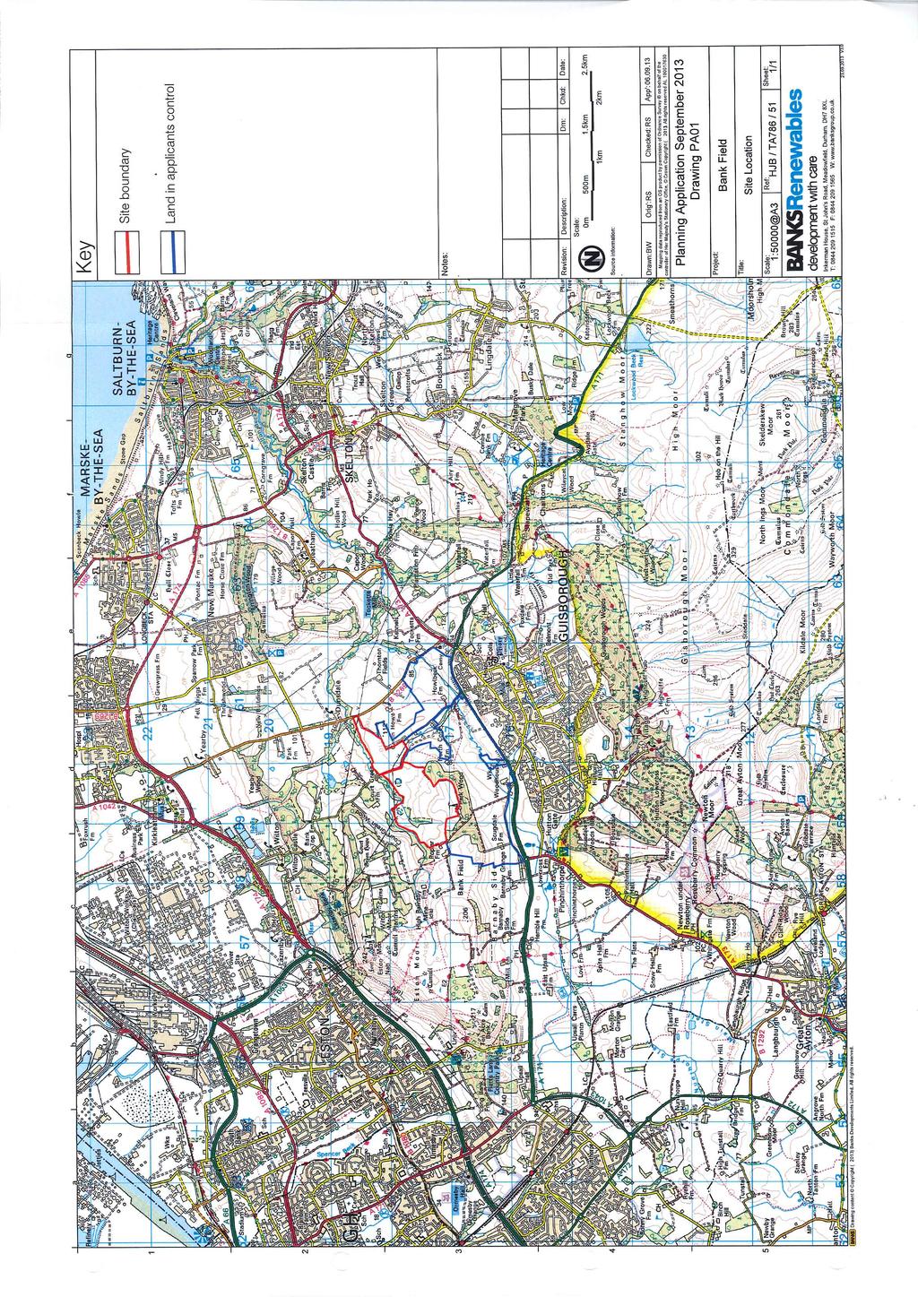
1 Item 8 North York Moors National Park Authority Planning Committee 12 December 2013 Consultation from Redcar and Cleveland Borough Council on proposed Wind Farm at Bank Field Guisborough 1. Purpose of the Report 1.1 The National Park has been consulted on the proposed development of a wind farm to the north of the Park and Members agreement is sought with regard to the proposed consultation response. 2. Consultation on Planning Application 2.1 An application for planning permission has been submitted to Redcar and Cleveland Borough Council for the development of a wind farm at Banks Field, Guisborough. A consultation letter was received by the North York Moors National Park Authority on 14 October 2013 requesting the opinion of the National Park Authority on the proposed development. 2.2 Generally consultations with regard to development close to the National Park boundary are dealt with under delegated powers and subsequently reported to Members for information purposes only. In this case Officers considered that the scale of the development was of sufficient note to warrant bringing a paper before Members. 2.3 The National Park Authority, in responding to consultations on development proposals outside the National Park, will comment only on those aspects of the development which could have a detrimental impact on the setting of the National Park and the Special Qualities of the National Park, therefore homing the purposes of designation. 3. Site Description 3.1 The application site is immediately to the north of Guisborough outside the National Park on an area of land with an elevation of between 110m and 180m above sea level. The site is approximately 2km from the National park boundary at its closest point (see attached plan at Appendix 1). The area is mostly agricultural in nature with small areas of woodland. 4. Proposed Development 4.1 The application is for the erection of 5 wind turbines, the construction of a new access track from the B1269, tower foundations and a crane pad for each turbine, a temporary site compound, site control building including electricity sub-station, hard-standing, fences and associated infrastructure. 4.2 The proposed sub-station and control room is to be housed in a building measuring 50m by 30m and clad in stone. It should be noted that the crane pads, which will be a relatively dominant feature during development will be removed and the land reinstated upon completion of development. Proposed Wind Farm at Bank Field Guisborough/1
2 4.3 The proposed wind turbines will have a hub height of 80m and an overall maximum blade tip height of 132m with a blade length of 52m. The turbines would be finished in a matt grey colour to be agreed with the Local Planning Authority. The maximum generating capacity of each turbine would not exceed 3.4MW. 5. Key Benefits of the Proposal 5.1 The applicant has set out the likely benefits of the proposal. These include benefits to the local community and the environment. These are outlined below: The development will contribute to National targets for renewable energy generation and greenhouse gas reduction. The installation would generate sufficient electricity to supply around 9,800 households assuming a consumption of 4,370kWh per annum per household. The development, with an installed capacity of 17MW would have the potential to offset the emission of up to 22,280 tonnes of CO 2 per annum equating to 557,000 tonnes of CO 2 over the 25 year lifespan of the project. Delivery of a substantial community benefits package for the local community. Local companies could benefit from the scheme through 3,000,000 worth of contracts. Ecological and habitat enhancements to be delivered in and around the area. An annual community benefits package totalling 85,000 per year available to local groups and organisations. For three years 60% of this will be earmarked to support youth training apprenticeships for people from Guisborough and Dunsdale. The remainder will focus on energy efficiency in the area. 6. Site of Special Scientific Interest and Special Area of Conservation 6.1 Natural England has been consulted with respect to the potential for impact on these specially designated locations and it has been determined that the development will have no adverse impact. 7. Visualisations 7.1 The submitted visualisations of the development give a relatively comprehensive feel for the generality of the visual impact, effectively showing where the development will be seen from and how much of the development will be seen from that vantage point. Unfortunately these types of images are limited in that they are static and do not give a feel for the true impact on an individual viewing the development in the landscape due to the length of time a receptor would view the development and the impact of the rotation of the turbine on the viewer. 8. Setting of the National Park and policy position 8.1 The National Planning Policy Framework states that the planning system should contribute to and enhance the natural and local environment by protecting and enhancing valued landscapes, geological conservation interests and soils. Proposed Wind Farm at Bank Field Guisborough/2
3 Local planning authorities should set criteria based policies against which proposals for any development on or affecting protected wildlife or geo-diversity sites or landscape areas will be judged. Distinctions should be made between the hierarchy of international, national and locally designated sites, so that protection is commensurate with their status and gives appropriate weight to their importance and the contribution that they make to wider ecological networks. Great weight should be given to conserving landscape and scenic beauty in National Parks, the Broads and Areas of Outstanding Natural Beauty, which have the highest status of protection in relation to landscape and scenic beauty. 8.2 The Planning Inspectorate in December 2012 at Public Inquiry held that the setting of a National Park should be considered in the assessment of an application in West Sussex. 8.3 It should be noted that the Draft Redcar and Cleveland Plan has a policy (SD6) which looks at Renewable Energy schemes and sets particular importance on minimising the impact of renewable energy on the North York Moors National Park. Policy N1 also seeks to protect the landscape setting and scenic beauty of the National Park by ensuring that development that would result in a significant impact on these features does not take place. 9. Impact on the National Park and Iconic Locations 9.1 Roseberry Topping, Park Nab, Captain Cook s Monument, Hanging Stone Viewpoint, High Cliff Nab, Low Moor Birkbrow and Carlton Bank are all important view points along the north and western edge of the National Park, from which points the proposed development will be clearly visible. Whilst the general impact of the development will lessen as one travels south and west from the site and the development will be seen in the context of the wider landscape, the proposed development will significantly harm the landscape character in views north to Roseberry Topping. 9.2 It should be noted that in the applicant s submission it states that from their Viewpoint 30 given the distance, the turbines will only be prominent in clear weather. However, these will be the only times that Roseberry Topping is also prominent. 9.3 The turbines viewed from the northern edge of the National Park, overlooking Guisborough, will be seen in the close context of what is a closed and intimate landscape. The result of this is that the scale and form of the proposed turbines, set at elevation above Guisborough, will have a significant harmful impact on the character of this landscape on the edge of the National Park. This part of the National Park is well used, particularly by Guisborough residents. 9.4 The turbines would be visible from a considerable area of the National Park, in locations where the context for the development will be largely the moorland area of the National Park. The result of this is that the receptor viewing the landscape of the Park will have imposed upon them the visual intrusion of the turbines. In some situations this will be a blade tip only. However, by virtue of the movement of the turbines, this will effectively result in the flash of turbine tips, again viewed largely in the context of the moorland landscape of the National Park. This will introduce a new and entirely unacceptable visual intrusion into the National Park Landscape which will result in a detrimental impact to the Special Qualities of the National Park in particular this will harm the feeling of remoteness and tranquility by visually bringing an industrialised development into the Park. Proposed Wind Farm at Bank Field Guisborough/3
4 9.5 The proposed development would have significant harmful impacts in terms of views of important iconic landscape forms and sites along the edge of the National Park. In particular Roseberry Topping and the scarp edge of the Cleveland Hills which form an important landscape feature of the northern-western boundary of the National Park. Due to the height of the turbines and the elevation of the application site, the proposed turbines will have a harmful and dominating impact on the prominence and visual integrity of Roseberry Topping and other escarpment features along the edge of the National Park. The western edge of the National Park is a prominent and delineating feature in the landscape which marks the sudden and dramatic transition between the lowland and upland landscapes. This character will be significantly eroded by the proposed development which will introduce a large manmade feature which will visually interfere with this visual transition. 10. Impact on Cleveland Way National Trail 10.1 The turbines would be visible with the possibility of a degree of framing of Roseberry Topping from certain locations from as early on in this important National Trail as Scarth Wood Moor and also be seen from most of Live Moor, Carlton Moor, Cringle Moor, Cold Moor, Hasty Bank and Round Hill (highest point on the NY moors). This is in addition to the close up views near Guisborough and through to Saltburn. The visualisations as mentioned previously represent spot points along the route, whereas in reality there will be significant and continuous impacts along the route with particularly high impact on the views of Roseberry Topping and along a substantial length of the Cleveland Way It should also be noted that there will be a significant impact on Coast to Coast users as well as users of the Cleveland Way, which appears to have been overlooked in the impact assessment Table 6.1 of the applicant submission defines the Visual Receptor Sensitivity. Based on this guideline sensitivity should always be recorded as High for users on a National Trail and / or in a National Park. However this has not been applied in the applicant s submission as regards the Cleveland Way. The result of this is that the Significance of effect has been incorrectly recorded in three cases. The actual significance of effect should be major / moderate rather than moderate. From this it appears that the Significance of effect on the Cleveland Way has been substantially underplayed in the proposal The applicant states that (pp96) in respect of the cumulative impact of wind farms (Seamer, Butterwick Moor, Bank Field and Teesside Offshore) Given that the 3 main wind farms are either operational or constructed and form part of the baseline assessment considered as part of the Landscape and Visual Impact Assessment there will be no further effect for users of the Cleveland Way other than those described for each viewpoint or location 10.5 It appears that no assessment of Sequential Cumulative Visual Effect has actually been carried out for the proposed development. The developers should provide evidence of consideration of the impact of the sequential Cumulative Visual Effect for the Cleveland Way taking into consideration the other wind farms visible from the Cleveland Way, in the region The proposed development will have a significant and harmful impact on the enjoyment of the Cleveland Way National Trail. Proposed Wind Farm at Bank Field Guisborough/4
5 The turbines would be visible from as early on the Cleveland Way route as Scarth Wood Moor and will also be seen from most of Live Moor, Carlton Moor, Cringle Moor, Cold Moor, Hasty Bank and Round Hill (Highest point on the NY moors). This is in addition to the close up views near Guisborough and through to Saltburn. The visualisations represent spot points along the route whereas in reality there will be significant impacts for a significant duration of the route and especially on iconic Roseberry Topping views. 11. Financial and Staffing Implications 11.1 None 12. Contribution to National Park Management Plan 12.1 National Park Management Plan Policy C11 seeks to ensure that the impacts of development outside but close to the Park are assessed in terms of their harm to the setting of the National Park. Policy C3 seeks to ensure that the landscape character is not harmed by new development. Objecting to the proposed development would help to meet these objectives by seeking to resist harmful development in the setting of the National Park. 13. Legal Implications 13.1 None 14. Recommendation That: 14.1 The North York Moors National Park Authority strongly objects to the proposed development due to the unacceptable obtrusive impact upon the landscape character and Special Qualities of the National Park and its setting by reason of the wind farm location s proximity to the North York Moors National Park, the size and elevation of the site and general land form in the locality which serves to emphasise the wide visibility of the project from parts of the National Park. In this respect it is considered that the proposal will significantly compromise the purposes of National Park designation and the National Park Authority urges Redcar and Cleveland Borough Council to refuse the application The above recommendation along with this report is submitted to Redcar and Cleveland Borough Council. Contact Officer Peter Jones Team Leader Planning Tel No Background papers to this Report File ref 1. Planning Enquiry 2013/ Redcar and Cleveland Borough Council Planning File Ref 2013/0674/FFM Proposed Wind Farm at Bank Field Guisborough/5
6
TOWN AND COUNTRY PLANNING (SCOTLAND) ACT 1997
 ACT 1997") TOWN AND COUNTRY PLANNING (SCOTLAND) ACT 1997 APPEAL AGAINST REFUSAL OF PLANNING PERMISSION FOR CONSTRUCTION OF WIND FARM, CONSISTING OF ERECTION OF 12 NO. WIND TURBINES, HEIGHT OF 70 METRES TO HUB, ASSOCIATED
TOWN AND COUNTRY PLANNING (SCOTLAND) ACT 1997 APPEAL AGAINST REFUSAL OF PLANNING PERMISSION FOR CONSTRUCTION OF WIND FARM, CONSISTING OF ERECTION OF 12 NO. WIND TURBINES, HEIGHT OF 70 METRES TO HUB, ASSOCIATED
Wind energy development in the South Pennines landscape
 Wind energy development in the South Pennines landscape Programme for today Background Policy context South Pennines landscape Impacts of wind energy development The South Pennines Wind Energy Landscape
Statutory and Non-Statutory Designated Sites and Ecology
 Statutory and Non-Statutory Designated Sites and Ecology The National Planning Policy Framework considers the conservation and enhancement of the natural environment in chapter 11 paragraphs 109-119, where
Schedule of Planning Applications Committee Date: 23 May Reference: 06/17/0726/F Parish: Hemsby Officer: Mr J Beck Expiry Date:
 Schedule of Planning Applications Committee Date: 23 May 2018 Reference: 06/17/0726/F Parish: Hemsby Officer: Mr J Beck Expiry Date: 22-05-2018 Applicant: Proposal: Site: Mr Gillett Change of use to the
List of Policies. SESPlan. None applicable. Consolidated Scottish Borders Local Plan 2011: POLICY G1 - QUALITY STANDARDS FOR NEW DEVELOPMENT
 List of Policies Local Review Reference: 15/00021/RREF Planning Application Reference: 15/00616/FUL Development Proposal: Installation of 16no solar photovoltaic (PV) panels to roof Location: Raebank,
3.1 This evidence is based on the landscape and visual impact assessment included in Chapter 10 and Appendix I of the EIS.
 LANDSCAPE & VISUAL 1 QUALIFICATIONS AND EXPERIENCE 1.1 My name is Raymond Holbeach and I am a Regional Director for RPS Planning & Environment with full responsibility for management of the RPS Belfast
Persimmon Homes Thames Valley Date received: 2 nd April week date(major): 2 nd July 2014 Ward: Nascot
: 2 nd July 2014 Ward: Nascot") PART A Report of: DEVELOPMENT MANAGEMENT SECTION HEAD Date of Committee: 26 th June 2014 Site address: Rounton, 28, Nascot Wood Road Reference Number: 14/00497/REM Description of Development: Reserved
PART A Report of: DEVELOPMENT MANAGEMENT SECTION HEAD Date of Committee: 26 th June 2014 Site address: Rounton, 28, Nascot Wood Road Reference Number: 14/00497/REM Description of Development: Reserved
Guidance for Wind Turbine Development in the Dorset Area of Outstanding Natural Beauty
 DRAFT January 2012 Guidance for Wind Turbine Development in the Dorset Area of Outstanding Natural Beauty Photo 1: Rew Manor Farm, West Dorset, chalk downland landscape (Planning application ref: 1/D/09/001280
PLANNING COMMITTEE DATE: 07/09/2015 REPORT OF THE SENIOR MANAGER PLANNING AND ENVIRONMENT SERVICE CAERNARFON. Number: 4
 Number: 4 Application Number: C15/0034/37/LL Date Registered: 21/05/2015 Application Type: Full - Planning Community: Llanaelhaearn Ward: Llanaelhaearn Proposal: Location: Summary of the Recommendation:
Guidance for Wind Turbine Development in the Dorset AONB
 Photo 1: Rew Manor Farm, West Dorset, chalk downland landscape (Planning application ref: 1/D/09/001280 1 ) Scale & siting: 12m to hub / 16m to blade tip. A well sited small scale turbine, grouped with
Parish of Repton NEIGHBOURHOOD DEVELOPMENT PLAN
 Parish of Repton NEIGHBOURHOOD DEVELOPMENT PLAN BASIC CONDITIONS STATEMENT December 2018 CEF 4 Legal Requirements This statement has been produced by the NDP Working Group on behalf of Repton Parish Council
Case Officer: Sarah Kay File No: CHE/14/00515/REM Tel. No: (01246) Plot No: 2/6132 Ctte Date: 15 th September 2014 ITEM 1
 Plot No: 2/6132 Ctte Date: 15 th September 2014 ITEM 1") Case Officer: Sarah Kay File No: CHE/14/00515/REM Tel. No: (01246) 345786 Plot No: 2/6132 Ctte Date: 15 th September 2014 ITEM 1 APPROVAL OF RESERVED MATTERS FROM APPLICATION CHE/12/00234/OUT (1) LAYOUT,
Case Officer: Sarah Kay File No: CHE/14/00515/REM Tel. No: (01246) 345786 Plot No: 2/6132 Ctte Date: 15 th September 2014 ITEM 1 APPROVAL OF RESERVED MATTERS FROM APPLICATION CHE/12/00234/OUT (1) LAYOUT,
Definition of Cumulative Landscape and Visual Effects
 SECTION 5: GUIDANCE FOR ASSESSING CUMULATIVE LANDSCAPE AND VISUAL EFFECTS 5.1 Although this landscape sensitivity and capacity study has identified that parts of the National Park may be able to accommodate
- - - Key Characteristics
 S23 Dyffryn Dysynni Reproduced from the Ordnance Survey map with the permission of Ordnance Survey on behalf of the Controller of Her Majesty s Stationery Office, Crown copyright Licence No. 100023387
STATEMENT OF OBJECTION TO THE PROPOSED DEVELOPMENT OF LAND AT CHURCH CLIFF DRIVE FILEY
 STATEMENT OF OBJECTION TO THE PROPOSED DEVELOPMENT OF LAND AT CHURCH CLIFF DRIVE FILEY You will be aware that Scarborough borough council have adopted a new local plan that includes land at Church Cliff
Development in the setting of the Cotswolds AONB
 COTSWOLDS CONSERVATION BOARD POSITION STATEMENT Development in the setting of the Cotswolds AONB.1. Introduction Areas of Outstanding Natural Beauty (AONBs) are designated by the Government for the purpose
Cotswolds AONB Landscape Strategy and Guidelines. June 2016
 Cotswolds AONB Landscape Strategy and Guidelines June 2016 Cotswolds AONB Landscape Strategy and Guidelines Introduction The evolution of the landscape of the Cotswolds AONB is a result of the interaction
SEABANK 3. Interim Landscape and Design Statement
 SEABANK 3 Interim Landscape and Design Statement Prepared for: SSE plc URS Infrastructure & Environment UK Limited. Scott House Alencon Link Basingstoke Hampshire RG21 7PP UK 1 TABLE OF CONTENTS 1 INTRODUCTION...
EAST OF ENGLAND OFFICE
 Mr Philip Isbell Direct Dial: 01223 582751 Mid Suffolk District Council 131 high Street Our ref: P00524468 Needham Market Ipswich Suffolk IP6 8DL 18 January 2017 Dear Mr Isbell T&CP (Development Management
RULE 6 (6) STATEMENT OF CASE
 STATEMENT OF CASE") RULE 6 (6) STATEMENT OF CASE Former Allerthorpe Park Golf Club, Allerthorpe, YO42 4RL Submitted on Behalf of Allerthorpe Parish Council Appeal by Turnwalk Ltd. and Park Leisure 2000 Ltd. Appeal Reference:
RULE 6 (6) STATEMENT OF CASE Former Allerthorpe Park Golf Club, Allerthorpe, YO42 4RL Submitted on Behalf of Allerthorpe Parish Council Appeal by Turnwalk Ltd. and Park Leisure 2000 Ltd. Appeal Reference:
ROCHFORD LOCAL DEVELOPMENT FRAMEWORK: Sustainability Appraisal/ Strategic Environmental Assessment. Rochford Core Strategy Preferred Options Document
 ROCHFORD LOCAL DEVELOPMENT FRAMEWORK: Sustainability Appraisal/ Strategic Environmental Assessment Non Technical Summary Rochford Core Strategy Preferred Options Document October 2008 SUSTAINABILITY APPRAISAL
DUNSFOLD NEIGHBOURHOOD PLAN Site Selection Policies
 DUNSFOLD NEIGHBOURHOOD PLAN Site Selection Policies The criteria for assessing sites for future housing and business development in Dunsfold are set out below. (Development criteria, covering what it is
UTT/17/2075/FUL - (BERDEN) (Referred to Committee by Councillor Janice Loughlin. Reason: In the Public Interest)
 (Referred to Committee by Councillor Janice Loughlin. Reason: In the Public Interest)") UTT/17/2075/FUL - (BERDEN) (Referred to Committee by Councillor Janice Loughlin. Reason: In the Public Interest) PROPOSAL: LOCATION: APPLICANT: Amendments to the design of a scheme for a 49.99MW battery
UTT/17/2075/FUL - (BERDEN) (Referred to Committee by Councillor Janice Loughlin. Reason: In the Public Interest) PROPOSAL: LOCATION: APPLICANT: Amendments to the design of a scheme for a 49.99MW battery
Lower Sensitivity. VS Classification Level 2: Exposed Upland/Plateau
 S05 Y Moelwynion Reproduced from the Ordnance Survey map with the permission of Ordnance Survey on behalf of the Controller of Her Majesty s Stationery Office, Crown copyright Licence No. 100023387 Location
CA//17/02777/FUL. Scale 1:1,250. Planning Services Canterbury City Council Military Road Canterbury Kent CT1 1YW
 O CA//17/02777/FUL Scale 1:1,250 Map Dated: 15/03/2018 Planning Services Canterbury City Council Military Road Canterbury Kent CT1 1YW AGENDA ITEM NO 16 PLANNING COMMITTEE APPLICATION NUMBER: SITE LOCATION:
Harrow Lane, St Leonards-on-Sea, East Sussex, TN37 7JZ ERECTION OF 113 DWELLINGS TOGETHER WITH ESTATE ROADS (DETAILED SUBMISSION)
") AGENDA ITEM NO: Report to: PLANNING BOARD Date: 10 September, 2003 Report from: Borough Planning Officer Application Address: Proposal: Application No: Recommendation: Ward: File No: Applicant: Interest:
AGENDA ITEM NO: Report to: PLANNING BOARD Date: 10 September, 2003 Report from: Borough Planning Officer Application Address: Proposal: Application No: Recommendation: Ward: File No: Applicant: Interest:
Lower Sensitivity. VS Classification Level 2: Exposed Upland/Plateau
 S04 Moel Hebog Reproduced from the Ordnance Survey map with the permission of Ordnance Survey on behalf of the Controller of Her Majesty s Stationery Office, Crown copyright Licence No. 100023387 Location
Lower Sensitivity. VS Classification Level 2: Hills, Lower Plateau & Scarp Slopes (74%)/ Lowland Valleys (17%) / Exposed Upland/Plateau (7%)
/ Lowland Valleys (17%) / Exposed Upland/Plateau (7%)") S06 Coedwig Gwydyr Reproduced from the Ordnance Survey map with the permission of Ordnance Survey on behalf of the Controller of Her Majesty s Stationery Office, Crown copyright Licence No. 100023387 Location
S06 Coedwig Gwydyr Reproduced from the Ordnance Survey map with the permission of Ordnance Survey on behalf of the Controller of Her Majesty s Stationery Office, Crown copyright Licence No. 100023387 Location
PLANNING COMMITTEE REPORT
 PLANNING COMMITTEE REPORT TO: BY: Planning Committee South Head of Development DATE: 19 December 2017 DEVELOPMENT: SITE: WARD: APPLICATION: APPLICANT: Conversion of existing water storage reservoir to
DEVELOPMENT MANAGEMENT REPORT
 ITEM A08-1 DEVELOPMENT MANAGEMENT REPORT TO: BY: DATE: DEVELOPMENT: SITE: WARD: APPLICATION: APPLICANT: Development Management Committee Development Manager Proposed live/work unit in connection with existing
Report Author/Case Officer: Joanne Horner Contact Details:
 APP 04 Application Number: 16/00140/FUL Other Two storey side extension to existing dwelling and formation of hard standing to provide parking for number 54 (Resubmission of withdrawn application 15/02852/FUL)
WilloWind Linfairn Limited Linfairn Wind Farm - Addendum. Planning Statement
 WilloWind Linfairn Limited Linfairn Wind Farm - Addendum Planning Statement December 2014 Report Summary The has been prepared by SgurrEnergy Ltd on behalf of WilloWind Linfairn Limited. The document provides
PARISH / WARD: Peacehaven / Peacehaven East PROPOSAL:
 APPLICATION ITEM LW/16/0802 NUMBER: NUMBER: 7 APPLICANTS NAME(S): Mr J Robison & Ms S Teng PARISH / WARD: Peacehaven / Peacehaven East PROPOSAL: Planning Application for Conversion of existing garage to
PHASE III: Reserved Matters Submission
 Statement of Compliance with the outline approval for the proposed residential development of land at: BURGES LANE, WIVELISCOMBE PHASE III: Reserved Matters Submission Foreword Contents: This Statement
LONDON BOROUGH OF WALTHAM FOREST
 LONDON BOROUGH OF WALTHAM FOREST Committee/Date: Planning 5th December 2006 Application reference: Applicant: Location: Proposed development: Wards affected: Appendices: 2006/1330/OUT Mr Z Ahmed Nita Villa
Assessing the impact of smallscale wind energy proposals on the natural heritage
 Scottish Natural Heritage Assessing the impact of smallscale wind energy proposals on the natural heritage Guidance March 2016 Version 3 1 Contents 1. Introduction. 3 2. Encouraging a spatial approach
Watford Local Plan Part 2 Publication Stage Environmental Report. Appendix 3: Consultation Comments
 Watford Local Plan Part 2 Publication Stage Environmental Report Appendix 3: Consultation Comments August 2016 Appendix 3 - Responses to Consultation of the Local Plan Part 2 As required by the SEA Directive,
Development in the Green Belt
 Supplementary Planning Document: Development in the Green Belt Consultation Draft February 2013 Local Development Framework How to comment This document was published on 21st March 2013 and comments should
Planning, Taxi Licensing and Rights of Way Committee Report. Application No: P/2013/0239 Grid Ref:
 Planning, Taxi Licensing and Rights of Way Committee Report Application No: P/2013/0239 Grid Ref: 329462.56 269584.05 Community Council: Knighton Town Council Valid Date: 05/03/2013 Officer: Holly-ann
Tennis Court Rear Of 3-5 Corringway London NW11 7ED
 Location Tennis Court Rear Of 3-5 Corringway London NW11 7ED Reference: 18/4122/FUL Received: 3rd July 2018 Accepted: 3rd July 2018 Ward: Garden Suburb Expiry 28th August 2018 Applicant: Ms Sarah Robinson
LONGDEN VILLAGE DEVELOPMENT STATEMENT
 LONGDEN VILLAGE DEVELOPMENT STATEMENT 2017-2027 1 Longden Development Statement 2017-2027 15/01/18 1. Background 1.1 Longden Village Longden village is a very rural and traditional community first mentioned
Suffolk Coastal Local Plan Review Issues and Options, August 2017, Public Consultation
 Suffolk Coastal Local Plan Review Issues and Options, August 2017, Public Consultation Having reviewed the issues and options documents, the Society has made the following response: Part 1 - Strategic
3 Abbey View Mill Hill London NW7 4PB
 Location 3 Abbey View Mill Hill London NW7 4PB Reference: 15/03203/HSE Received: 26th May 2015 Accepted: 16th June 2015 Ward: Mill Hill Expiry 11th August 2015 Applicant: Proposal: Mr Richard Benson Alterations
Decision by Trevor A Croft, a Reporter appointed by the Scottish Ministers
 Appeal Decision Notice T: 01324 696 400 F: 01324 696 444 E: dpea@scotland.gsi.gov.uk Decision by Trevor A Croft, a Reporter appointed by the Scottish Ministers Planning appeal reference: PPA-170-2107 Site
Longbridge Town Centre Phase 2 Planning Application
 Longbridge Town Centre Phase 2 Planning Application Non-Technical Summary of the Environmental Statement December 2013 Introduction A full application for Planning Permission has been submitted to Birmingham
Town and Country Planning Act 1990 Section 79 and Town and Country Planning (Inquiries Procedure) (England) Rules 2000
 (England) Rules 2000") Town and Country Planning Act 1990 Section 79 and Town and Country Planning (Inquiries Procedure) (England) Rules 2000 Statement of Case of Royal Botanic Gardens, Kew Application by Starbones Ltd. Land
Town and Country Planning Act 1990 Section 79 and Town and Country Planning (Inquiries Procedure) (England) Rules 2000 Statement of Case of Royal Botanic Gardens, Kew Application by Starbones Ltd. Land
Planning and Regulatory Committee 20 May Applicant Local Councillor Purpose of Report
 Planning and Regulatory Committee 20 May 2014 7. APPLICATION FOR PLANNING PERMISSION FOR THE CARRYING-OUT OF DEVELOPMENT PURSUANT TO PLANNING PERMISSION REFERENCE NUMBER 603451 DATED 28 FEBRUARY 2007 WITHOUT
Lower Sensitivity. VS Classification Level 2: Exposed Upland/Plateau
 S02 Y Carneddau Reproduced from the Ordnance Survey map with the permission of Ordnance Survey on behalf of the Controller of Her Majesty s Stationery Office, Crown copyright Licence No. 100023387 Location
HS2 Hybrid Bill Petitioning. Summary of SMBC Asks 23/09/13. Background
 Summary of SMBC Asks 23/09/13 Background The Council has a developed a significant number of asks and propositions for consideration by HS2 Ltd and Government throughout further development of the HS2
Reference: 15/06961/RCU Received: 13th November 2015 Accepted: 17th November 2015 Ward: Coppetts Expiry 12th January 2016
 Location 91 Manor Drive London N20 0XD Reference: 15/06961/RCU Received: 13th November 2015 Accepted: 17th November 2015 Ward: Coppetts Expiry 12th January 2016 Applicant: Mr Christos Papadopoulos Proposal:
3 Tretawn Gardens London NW7 4NP
 Location 3 Tretawn Gardens London NW7 4NP Reference: 16/7886/HSE Received: 12th December 2016 Accepted: 19th December 2016 Ward: Mill Hill Expiry 13th February 2017 Applicant: Proposal: Mr Murray Two storey
6B Bertram Road London NW4 3PN
 Location 6B Bertram Road London NW4 3PN Reference: 16/6621/RCU Received: 14th October 2016 Accepted: 19th October 2016 Ward: West Hendon Expiry 14th December 2016 Applicant: Proposal: Ms Kavita Singh Erection
Suffolk Coast & Heaths AONB Boundary Variation Project
 Suffolk Coast & Heaths AONB Boundary Variation Project 24 September 2014, David Vose, Jonathan Dix Background The project to formally consider a variation to the boundary of the SC&H AONB boundary www.naturalengland.org.uk
Sustainability Statement. Whitby Business Park Area Action Plan
 Sustainability Statement Whitby Business Park Area Action Plan November 2014 Contents Page 1. Introduction 1 2. Scoping 3 3. Sustainability Appraisal of Options 6 4. Assessment of Draft Area Action Plan
Garden Bridge Planning Application
 Planning Application Additional Verified photomontages and assessment September 2014 Contents Page 1 Visual assessment 2 1.1 Introduction 2 1.2 Baseline 2 1.3 Potential effects and good environmental
an Inspector appointed by the Secretary of State for Communities and Local Government
 Appeal Decision Site visit made on 23 January 2017 by Gareth Wildgoose BSc (Hons) MSc MRTPI an Inspector appointed by the Secretary of State for Communities and Local Government Decision date: 6 February
REFERENCE: B/03745/12 Received: 02 October 2012 Accepted: 05 October 2012 WARD(S): Totteridge Expiry: 30 November 2012.
: Totteridge Expiry: 30 November 2012.") LOCATION: 15A Pyecombe Corner, London, N12 7AJ REFERENCE: B/03745/12 Received: 02 October 2012 Accepted: 05 October 2012 WARD(S): Totteridge Expiry: 30 November 2012 Final Revisions: APPLICANT: PROPOSAL:
LOCATION: 15A Pyecombe Corner, London, N12 7AJ REFERENCE: B/03745/12 Received: 02 October 2012 Accepted: 05 October 2012 WARD(S): Totteridge Expiry: 30 November 2012 Final Revisions: APPLICANT: PROPOSAL:
49 Broughton Avenue London N3 3EN
 Location 49 Broughton Avenue London N3 3EN Reference: 17/3448/RCU Received: 30th May 2017 Accepted: 1st June 2017 Ward: Finchley Church End Expiry 27th July 2017 Applicant: Mr P Atwal Proposal: Erection
Copyright Nigel Deeley and licensed for reuse under this Creative Commons Licence
 1 Copyright Nigel Deeley and licensed for reuse under this Creative Commons Licence Prepared by the Neighbourhood Plan Steering Group on behalf of Garway Parish Council with assistance from 2 Table of
SOUTH CAMBRIDGESHIRE DISTRICT COUNCIL. Planning and New Communities Director
 SOUTH CAMBRIDGESHIRE DISTRICT COUNCIL REPORT TO: Planning Committee 9 January 2013 AUTHOR/S: Planning and New Communities Director S/2270/12/FL FEN DRAYTON 850m long flood defence embankment ranging in
South Worcestershire Development Plan. South Worcestershire Design Guide Supplementary Planning Document
 South Worcestershire Development Plan South Worcestershire Design Guide Supplementary Planning Document Statement of Consultation: Early Engagement Scoping Paper February 2017 1. Introduction 1.1 This
5 Eastlake Close, Petersfield, Hants, GU31 4ES SDNP/18/01399/TPO
 5 Eastlake Close, Petersfield, Hants, GU31 4ES SDNP/18/01399/TPO PART 2 SOUTH DOWNS NATIONAL PARK AUTHORITY PLANNING COMMITTEE REPORT OF THE HEAD OF PLANNING Applications to be determined by the council
11/04/2016. NPPF Paragraph 128. NPPF Paragraph 128. NPPF Paragraph 128. NPPF Paragraph 128. NPPF Paragraph 128
 Good practice in the preparation and understanding of NPPF-compliant heritage assessments/statements Stephen Bond, Heritage Places 1 NPPF Paragraphs 133-135 133: Where a proposed development will lead
Environmental Impact Assessment
 Environmental Impact Assessment Environmental impact assessment (EIA) is the process of systematically drawing together an assessment of the likely significant environmental effects of a development project.
8.0 Design and Form of Development 43/
 42/ 8.0 Design and Form of Development 43/ Rothwells Farm, Golborne/ Development Statement Figure 7. Site Constraints Key 44/ Site Boundary 360 Bus Route/Stops Existing Trees Underground Water Pipe Sensitive
SOUTH CAMBRIDGESHIRE DISTRICT COUNCIL
 SOUTH CAMBRIDGESHIRE DISTRICT COUNCIL REPORT TO: Development and Conservation Control Committee 2 nd November 2005 AUTHOR/S: Director of Development Services S/1644/05/A - Willingham Two Lanterns with
Assessment of Landscape, Visual and Natural Character Effects
 Assessment of Landscape, Visual and Natural Character Effects Consent Footprint Amendments Mangamaunu Half Moon Bay Okiwi Bay South Report prepared for: New Zealand Transport Agency and KiwiRail Holdings
Effingham Neighbourhood Plan 1. Basic Conditions Statement
 Effingham Neighbourhood Plan 1 Basic Conditions Statement Effingham Neighbourhood Plan 2016: Basic Conditions Statement 2 Contents This statement has been prepared by Effingham Parish Council to accompany
Canterbury City Council Military Road Canterbury Kent CT1 1YW. Title: CA/16/02745/ADV. Author: Planning and Regeneration.
 O Crown copyright and database rights 2017 Ordnance Survey 100019614 Title: CA/16/02745/ADV Author: Planning and Regeneration Scale 1:1,250 Map Dated: 23/01/2017 Canterbury City Council Military Road Canterbury
Test Valley Borough Council Southern Area Planning Committee 8 January 2019
 ITEM 11 APPLICATION NO. 18/02218/FULLS APPLICATION TYPE FULL APPLICATION - SOUTH REGISTERED 23.08.2018 APPLICANT Rugby Football Union SITE The Trojans Club, Stoneham Lane, Eastleigh, SO50 9HT, CHILWORTH
S18 Mynyddoedd Yr Aran
 S18 Mynyddoedd Yr Aran Reproduced from the Ordnance Survey map with the permission of Ordnance Survey on behalf of the Controller of Her Majesty s Stationery Office, Crown copyright Licence No. 100023387
1 The development hereby permitted shall be carried out in accordance with the following approved plans:
 Location 59 Greenway Close London N20 8ES Reference: 16/00011/HSE Received: 30th December 2015 Accepted: 7th January 2016 Ward: Totteridge Expiry 3rd March 2016 Applicant: Mr Ankit Shah Proposal: Part
Mid Wales (Powys) Conjoined Wind Farms Public Inquiry:
 Conjoined Wind Farms Public Inquiry:") Mid Wales (Powys) Conjoined Wind Farms Public Inquiry: Application by RES UK & Ireland Limited, dated 27 March 2009 for consent under Section 36 of the Electricity Act 1989 to construct and operate a 100MW
Mid Wales (Powys) Conjoined Wind Farms Public Inquiry: Application by RES UK & Ireland Limited, dated 27 March 2009 for consent under Section 36 of the Electricity Act 1989 to construct and operate a 100MW
Babergh and Mid Suffolk Joint Draft Local Plan Consultation, August 2017, Public Consultation
 Babergh and Mid Suffolk Joint Draft Local Plan Consultation, August 2017, Public Consultation Having reviewed the documents, the Society has made the following response: Housing Delivery Q 7. Do you agree
SOUTH CAMBRIDGESHIRE DISTRICT COUNCIL. Executive Director (Operational Services) Corporate Manager (Planning and New Communities)
 Corporate Manager (Planning and New Communities)") SOUTH CAMBRIDGESHIRE DISTRICT COUNCIL REPORT TO: Planning Committee 12 January 2011 AUTHOR/S: Executive Director (Operational Services) Corporate Manager (Planning and New Communities) Notes: S/1848/10
SOUTH CAMBRIDGESHIRE DISTRICT COUNCIL REPORT TO: Planning Committee 12 January 2011 AUTHOR/S: Executive Director (Operational Services) Corporate Manager (Planning and New Communities) Notes: S/1848/10
Salhouse Parish Council, 11 th November Response to Planning Application
 Salhouse Parish Council, 11 th November 2013 Response to Planning Application 20131408 Summary Salhouse Parish Council (SPC) has received via Broadland District Council a Planning Application for a 5MWp
CAIRNGORMS NATIONAL PARK AUTHORITY
 Title: Prepared by: CONSULTATION FROM ANGUS COUNCIL KATHERINE DONNACHIE, PLANNING OFFICER (DEVELOPMENT MANAGEMENT) DEVELOPMENT PROPOSED: (1) ERECTION OF GAIA TURBINE OF 18 M. HUB HEIGHT AND 23.5 M. TO
Replacement Golf Course Facilities and Residential Development, Churston. Environmental Statement Non-Technical Summary
 Replacement Golf Course Facilities and Residential Development, Churston Environmental Statement Non-Technical Summary July 2011 Reproduced from the Ordnance Survey s map with the permission of the Controller
an Inspector appointed by the Secretary of State for Communities and Local Government
 Appeal Decision Site visit made on 6 November 2017 by Rachel Walmsley BSc MSc MA MRTPI an Inspector appointed by the Secretary of State for Communities and Local Government Decision date: 19 th January
18 Birkbeck Road London NW7 4AA. Reference: 15/02994/HSE Received: 14th May 2015 Accepted: 26th May 2015 Ward: Mill Hill Expiry 21st July 2015
 Location 18 Birkbeck Road London NW7 4AA Reference: 15/02994/HSE Received: 14th May 2015 Accepted: 26th May 2015 Ward: Mill Hill Expiry 21st July 2015 Applicant: Proposal: Mrs Tania Kallis Single storey
Landscape considerations in Forests & Woodlands. Jill Bullen, Senior Landscape Specialist
 Landscape considerations in Forests & Woodlands Jill Bullen, Senior Landscape Specialist UK Forestry Standard (UKFS) Sustainable forest management Landscape sub-section (S6.4, page 96) Standards and requirements
Ground Floor Flat 15 Redbourne Avenue London N3 2BP
 Location Ground Floor Flat 15 Redbourne Avenue London N3 2BP Reference: 17/4160/FUL Received: 28th June 2017 Accepted: 29th June 2017 Ward: West Finchley Expiry 24th August 2017 Applicant: Proposal: Mr
SOUTH CAMBRIDGESHIRE DISTRICT COUNCIL. Planning and New Communities Director
 SOUTH CAMBRIDGESHIRE DISTRICT COUNCIL REPORT TO: Planning Committee 5 June 2013 AUTHOR/S: Planning and New Communities Director S/0747/13/FL HISTON Construction of Car Park at Histon Baptist Church, Station
INTRODUCTION. Land West of Main Road, Stanton Harcourt THE SITE. Why is the Site Suitable for Development?
 0 INTRODUCTION THE SITE Application Boundary Gladman Developments Ltd has successfully invested in communities throughout the UK over the past 0 years, developing high quality and sustainable residential,
Great Easton Neighbourhood Plan Statement of Basic Conditions
 Great Easton Neighbourhood Plan 2017-2031 Statement of Basic Conditions OCTOBER 2016 GREAT EASTON PARISH COUNCIL Contents 1.0 Introduction....Page 2 2.0 Summary of Submission Documents and Supporting Evidence..
S08 Dyffryn Y Ddwyryd
 S08 Dyffryn Y Ddwyryd Reproduced from the Ordnance Survey map with the permission of Ordnance Survey on behalf of the Controller of Her Majesty s Stationery Office, Crown copyright Licence No. 100023387
Change of use and development of land to form The Stour Valley Visitor Centre at Horkesley Park.
 Sue Jackson Principal Planning Officer Colchester Borough Council PO Box 889 Rowan House 33 Sheepen Road Colchester CO3 3WG By email only 2 Aug 2012 Dear Ms Jackson, 120965 Change of use and development
Section Three, Appendix 16C Medium Density Housing, Design Assessment Criteria (Residential 8A zone)
") APPENDIX 16C MEDIUM DENSITY HOUSING, DESIGN ASSESSMENT CRITERIA (RESIDENTIAL 8A ZONE) PURPOSE OF APPENDIX 16C (RESIDENTIAL 8A ZONE) In the Residential 8A Zone the following are defined as restricted discretionary
APPENDIX 16C MEDIUM DENSITY HOUSING, DESIGN ASSESSMENT CRITERIA (RESIDENTIAL 8A ZONE) PURPOSE OF APPENDIX 16C (RESIDENTIAL 8A ZONE) In the Residential 8A Zone the following are defined as restricted discretionary
SOUTH CAMBRIDGESHIRE DISTRICT COUNCIL. Planning and New Communities Director
 SOUTH CAMBRIDGESHIRE DISTRICT COUNCIL REPORT TO: Planning Committee 3 October 2012 AUTHOR/S: Planning and New Communities Director S/1723/12/OL CAXTON AND ELSWORTH OUTLINE APPLICATION FOR ERECTION OF RESTAURANT/TAKEAWAY
Proposal: Proposed new access road. The application site is Council owned land and the decision level is at Planning and Licensing Committee.
 Reference: 16/01492/FUL Ward: Warley Site: Lion Lodge South The Avenue Warley Essex CM13 3RZ Proposal: Proposed new access road Plan Number(s): 1:1250 LOCATION PLAN; MB.DJA 1 OF 1; Applicant: Mr M Bryan
LAND AT WEST YELLAND. Environmental Statement Non-Technical Summary Welbeck Strategic Land LLP
 LAND AT WEST YELLAND Environmental Statement Non-Technical Summary Welbeck Strategic Land LLP May 2014 Quality Management Issue/revision Issue 1 Revision 1 Revision 2 Revision 3 Remarks Draft FINAL Date
RYEDALE SITES LOCAL PLAN MATTER 3 HOUSING ALLOCATION SITE REF.SD5 LAND EAST OF WHITBY ROAD, PICKERING DAVID WILSON HOMES REPRESENTOR ID: 1073
 RYEDALE SITES LOCAL PLAN MATTER 3 HOUSING ALLOCATION SITE REF.SD5 LAND EAST OF WHITBY ROAD, PICKERING INTRODUCTION DAVID WILSON HOMES REPRESENTOR ID: 1073 1.1 We write on behalf of our client David Wilson
Birmingham University, Pritchatts Road, Adjacent to Gisbert Kapp Building, Edgbaston, Birmingham, B15
 Committee Date: 07/03/2013 Application Number: 2013/00181/PA Accepted: 10/01/2013 Application Type: Reserved Matters Target Date: 11/04/2013 Development Ward: Edgbaston Birmingham University, Pritchatts
ENVIRONMENTAL STATEMENT REPORT 5.0 PLANNING POLICY CONTEXT
 5.0 PLANNING POLICY CONTEXT 5.1 Introduction 5.1.1 The Planning Policy Framework impacting on Yennadon Quarry is evolving and has been subject to recent change. A key factor has been the introduction of
Draft Shropshire Hills AONB Management Plan POLICIES
 Draft Shropshire Hills AONB Management Plan 2019-24 - POLICIES POLICY LM1 - Land Management Supporting Landscape and Natural Beauty i) Habitats and Networks Existing areas of high quality habitat should
CHANGE OF USE FROM PADDOCK TO RESIDENTIAL GARDEN LAND AT Yew Tree Cottage, Timpson Lane, Clifton Reynes FOR Iain Morrison
 08/01064/FUL CHANGE OF USE FROM PADDOCK TO RESIDENTIAL GARDEN LAND AT Yew Tree Cottage, Timpson Lane, Clifton Reynes FOR Iain Morrison INTRODUCTION Yew Tree Cottage is a detached dwelling at the northern
Visualisations for aquaculture
 Scottish Natural Heritage Visualisations for aquaculture Draft Guidance Note draft 1 Contents Section 1 1 Summary of recommendations 1 Section 2 4 Introduction 4 Landscape and Visual Impact Assessment
CAIRNGORMS NATIONAL PARK AUTHORITY
 CAIRNGORMS NATIONAL PARK AUTHORITY Title: Prepared by: CONSULTATION FROM SCOTTISH GOVERNMENT KATHERINE DONNACHIE PLANNING OFFICER (DEVELOPMENT MANAGEMENT) DEVELOPMENT PROPOSED: REFERENCE: APPLICANT: RECOMMENDATION:
1. Listed Building and Conservation Area considerations 2. Protection of Known Archaeological Remains 3. Parking
 08/01222/FUL ERECTION OF SINGLE STOREY SIDE EXTENSION TO CHURCH TO PROVIDE FOR PARISH HALL (RESUBMISSION OF 08/00206/FUL) AT St Mary And St Giles Church, Church Street, Stony Stratford FOR Rev R Northing
Proposed Plan Change 55: District Wide Rules. Hearing Report
 Proposed Plan Change 55: District Wide Rules Hearing Report Appendix 5 BEFORE THE HEARINGS PANEL In the Matter of: The Resource Management Act 1991 And Proposed Plan Change 55: Chapter 3 District Wide