Development of a Resource Planning Index for Washington's Scenic and Recreational Highways
|
|
|
- Garry Magnus Phelps
- 5 years ago
- Views:
Transcription


1 Development of a Resource Planning Index for Washington's Scenic and Recreational Highways WA-RD Kevin Ramsey February 2010 WSDOT Research Report Office of Research & Library Services
2
3 Final Technical Report Research Project Agreement No. T4118, Task 54 Development of a Resource Planning Index for Washington s Scenic and Recreational Highways By Kevin Ramsey, Ph.D. University of Washington Department of Geography University of Washington, Bx Seattle, Washington Washington State Transportation Center (TRAC) University of Washington, Box University District Building 1107 NE 45th Street, Suite 535 Seattle, Washington Washington State Department of Transportation Technical Monitor Paula Reeves MCP, Local Planning Branch Manager A report prepared for The State of Washington Department of Transportation Paula J. Hammond, Secretary February 2010
4 TECHNICAL REPORT STANDARD TITLE PAGE 1. REPORT NO. 2. GOVERNMENT ACCESSION NO. 3. RECIPIENT'S CATALOG NO. WA-RD TITLE AND SUBTITLE 5. REPORT DATE Development of a Resource Planning Index for Washington s February PERFORMING ORGANIZATION CODE Scenic and Recreational Highways 7. AUTHOR(S) 8. PERFORMING ORGANIZATION REPORT NO. Kevin Ramsey 9. PERFORMING ORGANIZATION NAME AND ADDRESS 10. WORK UNIT NO. University of Washington 11. CONTRACT OR GRANT NO. Office of Sponsored Programs 1100 NE 45 th, Suite 300 Agreement T Seattle, WA SPONSORING AGENCY NAME AND ADDRESS 13. TYPE OF REPORT AND PERIOD COVERED Research Office Washington State Department of Transportation Transportation Building, MS Olympia, Washington Kathy Lindquist, Project Manager, SUPPLEMENTARY NOTES Final Technical Report 14. SPONSORING AGENCY CODE This study was conducted in cooperation with the U.S. Department of Transportation, Federal Highway Administration. 16. ABSTRACT Washington State Department of Transportation Local Programs Division requested the creation of a Resource Planning Index (or Index ) for use in benchmarking and tracking the stewardship performance of investments associated with Washington s Scenic and Recreational Highways. A GIS analysis was performed to develop a unique Index value for each 1000 feet of roadway. The Index value was calculated based on the proximity of features of interest associated with specific opportunities for protecting, preserving, or enhancing resources associated with the state Scenic and Recreational Highways. This Index may be used in preliminary assessments of locations where there may be a confluence of such opportunities. As always, a local scale analysis of the location should assess exactly what opportunities exist there and whether a proposed project would actually provide the desired benefit or impact. 17. KEY WORDS 18. DISTRIBUTION STATEMENT Scenic and Recreational Highways No restrictions. This document is available to the public through the National Technical Information Service, Springfield, VA SECURITY CLASSIF. (of this report) 20. SECURITY CLASSIF. (of this page) 21. NO. OF PAGES 22. PRICE None None 16
5 Development of a Resource Planning Index for Washington s Scenic and Recreational Highways Contents 1. INTRODUCTION IDENTIFICATION OF OPPORTUNITIES DATA COLLECTION AND QUALITY ASSURANCE INDEX CALCULATION METHODOLOGY IDENTIFICATION OF LOCATIONS OF HIGHEST POTENTIAL LIMITATIONS OF THE RESOURCE PLANNING INDEX RECOMMENDED USE OF THE RESOURCE PLANNING INDEX Table 1 Data Included in the Resource Planning Index Analysis... 5 Figure 1 Figure 2 Resource Planning Index Values for Scenic and Recreational Highways Locations of Highest Potential for Protecting, Preserving, and Enhancing Resources Associated with Washington Scenic and Recreational Highways iii
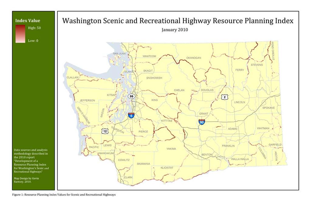
6 1. INTRODUCTION Washington State Department of Transportation Local Programs Division requested the creation of a Resource Planning Index for use in benchmarking and tracking the stewardship performance of investments associated with Washington s Scenic and Recreational Highways. For the purpose of this study, stewardship is defined as protecting, preserving, and enhancing resources associated with the state Scenic and Recreational Highways. 1 These resources may be scenic (e.g., view shed), environmental (e.g. ecosystems, water quality, or wildlife habitats), or historic (e.g, historic locations). The Resource Planning Index (or Index ) provides a rough measure of the potential for locations along Scenic and Recreational Highways to benefit from stewardship oriented projects. The State Scenic and Recreational Highway System was established by the State Legislature based on a 1962 visual quality assessment of state highways. This assessment identified and selected state highways with significant scenic resources. Visual assessments were conducted two additional times before 1990, confirming the state s Scenic and Recreational Highway System. This study compiles available GIS data to build on the visual assessments of the past. WSDOT recognizes that projects intended to serve the goal of increasing tourism or economic development may or may not also serve the goal of stewardship. WSDOT also recognizes that there is an opportunity to increase emphasis on accomplishing both tourism/economic development and stewardship. This analysis focuses exclusively on the goal of stewardship. More detailed and local scale analysis conducted as part of corridor plan or other plans will be required to evaluate whether individual investments can address the goals of both stewardship and tourism/economic development. The findings from this statewide analysis of stewardship potential are preliminary. These findings should be used as a first cut guide to highlight areas in the Scenic and Recreational Highway System that have a high potential for protecting, preserving, and enhancing resources associated with the state Scenic and Recreational Highways. 1 Steering Committee Meeting, State Scenic and Recreational Highway Plan, September 24, 2009; p. 3. 1
7 2. IDENTIFICATION OF OPPORTUNITIES The first step in this analysis was to identify different kinds of opportunities for protecting, preserving, or enhancing resources associated with the state Scenic and Recreational Highways. These opportunities take into consideration the kinds of impacts that highways can have on scenic, environmental, and historic resources as well as ways in which those impacts can be mitigated. Opportunities considered in this analysis are listed as follows:! Enhancing the viability of existing habitats and ecosystems Scenic and recreational highways have inevitable impacts on the existing habitats and ecosystems in their proximity including storm water run off, watershed function, noise and air pollution, habitat fragmentation, and facilitating the development of unprotected lands. Areas with existing habitats and ecosystems provide opportunities to mitigate potential impacts through stewardship projects including overlay zones, the purchase of land or conservation easements, or roadway design improvements that mitigate sound, air, or water pollution resulting from roadway traffic.! Enhancing the viability of known habitat corridors Numerous species of concern in Washington State need to move between habitat areas to survive, reproduce, and maintain their genetic fitness. Identification of priority habitat corridors for Grizzly Bear, Wolf, Canada Lynx, and Wolverine has been completed. However, a more comprehensive effort is underway and likely to produce map products by the end of Maintaining suitable conditions in identified corridors throughout the state is crucial to habitat connectivity and the long term health of many wildlife populations. Scenic and recreational highways, and the development of land to which they provide access, may impact habitat connectivity. Investments such as roadside habitat preservation or (in the case of major highways) bridges for wildlife passage can mitigate these impacts and enhance the viability of habitat corridors.! Reducing impacts to species at particular risk of road kills Some priority habitat areas within Washington contain species that are at particular risk to collisions with vehicles on sections of scenic and recreational highways. For instance, several reptile species move slowly and are attracted to the heat emanated by road surfaces at night. 2 Areas rich with these species provide opportunities for roadway design improvements that can help to reduce road kills.! Enhancing the viability aquatic and riparian habitat Scenic and recreational highways, as well as the development of land to which they provide access, may have implications for the viability of aquatic and riparian habitat. A majority of fish and wildlife species in Washington 2 According to Kelly McAllister, Habitat Connectivity Biologist at WSDOT. 2
8 depend on aquatic and riparian ecosystems for all or part of their life cycle. 3 This includes a number of federally listed endangered and threatened species, such as salmon. Opportunities to mitigate impacts on these ecosystems may include improved culvert design for fish passage, improved management and treatment of roadway runoff, riparian habitat restoration along scenic and recreational highways, and protection of aquatic or riparian habitats near scenic and recreational highways.! Reducing impacts to places of scenic, cultural, and historic significance Places of scenic, cultural, and historic significance in Washington State can be detrimentally impacted by highway traffic and development pressures. Specific impacts include noise and air pollution as well as nearby development that can alter the character of these places. Such impacts can be reduced or mitigated by historic preservation, the purchase of land or conservation easements to preserve view sheds, or improved roadway design. This analysis assumes locations with multiple opportunities for protecting, preserving, and enhancing resources associated with the state Scenic and Recreational Highways have a higher potential for benefits than other locations. In other words: the more opportunities that exist in a location, the higher the potential for benefit. Locations with high potential will be assigned a correspondingly higher Index value and corresponding color on the map (see Figure 1). 3 Washington Department of Fish and Wildlife, Design of Road Culverts for Fish Passage, 3
9 3. DATA COLLECTION AND QUALITY ASSURANCE Existing spatial data resources relevant to determining areas with high potential for protecting, preserving, and enhancing resources associated with the state Scenic and Recreational Highways were collected and assessed for quality. Table 1 includes a listing of all data used in the development of the Resource Planning Index. These data are grouped as features of interest that are associated with specific opportunities identified in Section 2. 4
10 Table 1: Data Included in the Resource Planning Index Analysis Feature of Interest Relevant Opportunity Data Title Data Source Data Description Protected areas Enhancing the viability of existing habitats and ecosystems Enhancing the viability aquatic and riparian habitat Reducing impacts to places of scenic, cultural, and historic significance Natural Area Preserves (NAP) Natural Resource Conservation Areas (NCRA) Wildlife areas and refuges National Parks WA State Parks USFS Wilderness Areas Dept. of Natural Resources Dept. of Natural Resources Dept. of Fish and Wildlife National Park Service State Parks USFS Polygon data describing the location of NAPs in Washington. NAPs protect the best remaining examples of many ecological communities including rare plant and animal habitat. 4 These areas are not intended for recreational purposes. Polygon data describing the location of NCRAs in Washington. Conservation areas protect outstanding examples of native ecosystems, habitat for endangered, threatened and sensitive plants and animals, and scenic landscapes. Environmental education and low impact public use are appropriate on conservation areas where they do not impair the resource values of the area protected. 5 Polygon data describing protected areas designated for wildlife conservation. Polygon data describing the location of National Parks in Washington. National Parks are tourism and recreational destinations that preserve natural and cultural resources. Polygon data describing the location of State Parks in Washington. State parks are tourism and recreational destinations that preserve natural and cultural resources. Polygon data describing the location of federally designated Wilderness Areas in Washington State. These public lands are protected from all development and allow only for low impact recreation. TNC nature preserves National Recreation Areas TNC WSDOT Polygon data describing the location of all preserves owned and managed by The Nature Conservancy. These preserves are open to the public for low impact recreational activities. Polygon data describing the location of all National Recreation Areas in Washington
11 Priority Habitat Areas Natural Heritage Areas Enhancing the viability of existing habitats and ecosystems Enhancing the viability of existing habitats and ecosystems Talus slope Shrub steppe Prairie Natural Heritage Areas Dept. of Fish and Wildlife Dept. of Fish and Wildlife Dept. of Fish and Wildlife Dept. of Natural Resources Polygon data describing talus slope habitats in Washington State. According to Kelly McAllister, Habitat Connectivity Biologist, this habitat type captures some of the more reptile rich areas in Washington which is significant for highways since reptiles are subject to elevated road kill risk due to their slow moving nature and attraction to heat being emanated, at night, from road surfaces. Polygon data describing shrub steppe habitats in Washington State. Habitat recommended for consideration by Kelly McAllister, Habitat Connectivity Biologist due to the many species of concern associated with this rare and declining habitat type. Polygon data describing prairie habitats in Washington State. Habitat recommended for consideration by Kelly McAllister, Habitat Connectivity Biologist due to the many species of concern associated with this rare and declining habitat type. Polygon data describing areas with rare plants and ecological communities that have been prioritized for conservation efforts by Washington Natural Heritage Program (WNHP) within the Department of Natural Resources. 6 These areas are likely to be unsuitable for recreation oriented investments (due to impacts of people traffic on wildlife). Wildlife corridors Enhancing the viability of known habitat corridors Lynx corridors Wolf corridors Wolverine corridors Raster data regarding landscape permeability for lynx in Washington State. Cells are valued based on a habitat connectivity analysis conducted by biologist Peter Singleton. Locations that are most viable as habitat corridors are given the highest value. Source habitats for lynx were also included in this analysis and treated as corridors of highest viability. Raster data regarding landscape permeability for wolves in Washington State. Cells are valued based on a habitat connectivity analysis conducted by biologist Peter Singleton. Locations that are most viable as habitat corridors are given the highest value. Source habitats for wolves were also included in this analysis and treated as corridors of highest viability. Raster data regarding landscape permeability for wolverines in Washington State. Cells are valued based on a habitat connectivity analysis conducted by biologist Peter Singleton. Locations that are most viable as habitat corridors are given the highest value. Source habitats for wolverines were also included in this analysis and treated as corridors of highest viability
12 Lakes, wetlands, rivers and streams Enhancing the viability aquatic and riparian habitat Grizzly bear corridors Streams and rivers Lakes and wetlands Dept. of Ecology Dept. of Ecology Raster data regarding landscape permeability for grizzly bears in Washington State. Cells are valued based on a habitat connectivity analysis conducted by biologist Peter Singleton. Locations that are most viable as habitat corridors are given the highest value. Source habitats for grizzly bears were also included in this analysis and treated as corridors of highest viability. Arc data regarding streams and rivers listed in the Washington Shoreline Management act. 7 A 1000 foot buffer around these areas was created for the purpose of analysis. Polygon data regarding lakes and wetlands listed in the Washington Shoreline Management act. 8 A 1000 foot buffer around these areas was created for the purpose of analysis. Impacted waterways Fish barriers Enhancing the viability aquatic and riparian habitat Enhancing the viability aquatic and riparian habitat Class 2 impacted waterways Class 4 (A, B, & C) impacted waterways Class 5 impacted waterways Dept. of Ecology Dept. of Ecology Dept. of Ecology Polygon data describing waters of concern. These waterways have evidence of water quality degradation. A 1000 foot buffer around these areas was created for the purpose of analysis. Polygon data describing polluted waters that do not require a TMDL (Total Maximum Daily Load). A 1000 foot buffer around these areas was created for the purpose of analysis. Polygon data describing polluted waters that require a TMDL (Total Maximum Daily Load). A 1000 foot buffer around these areas was created for the purpose of analysis. Fish Barriers WSDOT Point data of locations where fish passage across WA roadways is impeded 7 ftp:// 8 ftp:// 7
13 Historic locations Reducing impacts to places of scenic, cultural, and historic significance Nationally registered historic locations Dept. of Archeology and Historic Preservation Point data describing nationally registered historic places in Washington State. These locations are being preserved for their historic significance. A 1000 foot buffer around these areas was created for the purpose of analysis. Current and future land use Enhancing the viability of existing habitats and ecosystems Enhancing the viability aquatic and riparian habitat Reducing impacts to culturally and historically significant places Benton Benton Co. Visual inspection of online comprehensive plan map 9 indicates no conflict with areas of high stewardship potential. Chelan Polygon data regarding parcels zoned or planned for commercial, industrial, or Clallam Polygon data regarding parcels zoned or planned for commercial, industrial, or Clark Clark Co. Polygon data regarding parcels zoned or planned for commercial, industrial, or Franklin Franklin Co. Polygon data regarding parcels zoned or planned for commercial, industrial, or Grant Grant Co. Polygon data regarding parcels zoned or planned for commercial, industrial, or Grays Harbor Grant Co. Polygon data regarding parcels zoned or planned for commercial, industrial, or Jefferson Jefferson Co. Polygon data regarding parcels zoned or planned for commercial, industrial, or King King Co. Polygon data regarding parcels zoned or planned for commercial, industrial, or Kitsap Polygon data regarding parcels zoned or planned for commercial, industrial, or Klickitat Polygon data regarding parcels zoned or planned for commercial, industrial, or 9 COM_PLAN_ _ pdf 8
14 Mason Polygon data regarding parcels zoned or planned for commercial, industrial, or Okanogan Polygon data regarding parcels zoned or planned for commercial, industrial, or Pacific Pacific Co. Polygon data regarding parcels zoned or planned for commercial, industrial, or Pierce Pierce Co. Polygon data regarding parcels zoned or planned for commercial, industrial, or San Juan San Juan Co. Zoning data received from county. Metadata not yet available for review. Skagit Skagit Co. Polygon data regarding parcels zoned or planned for commercial, industrial, or Snohomish Snohomish Co. Polygon data regarding parcels zoned or planned for commercial, industrial, or Spokane Spokane Co. Polygon data regarding parcels zoned or planned for commercial, industrial, or Stevens Zoning data received from. No metadata is available to assess its relevance to stewardship priorities. Therefore it is not included in this analysis. Thurston Polygon data regarding parcels zoned or planned for commercial, industrial, or Watcom Watcom Co. Polygon data regarding parcels zoned or planned for commercial, industrial, or Yakima Polygon data regarding parcels zoned or planned for commercial, industrial, or 9
15 4. INDEX CALCULATION METHODOLOGY The data sets listed in Table 1 of this report were analyzed to create a unique data set called a Resource Planning Index for the purpose of this report. This Index assigns values to locations along Scenic and Recreational Highways based on the potential to protect, preserve, or enhance resources associated with the state Scenic and Recreational Highways. The Index data is organized in the form of a raster grid with cells that correspond to 1000 feet on the ground. The Index value for each is calculated based on the presence (or in some cases, proximity) of a feature of interest that is relevant to an opportunity to protect, preserve, or enhance resources associated with the state Scenic and Recreational Highways (see Section 2 and Table 1 above). If a cell intersects multiple features of interest, its Index value will be higher. All features of interest are weighed equally in this analysis, with the exception of wildlife corridors. The weight assigned for these corridors is graduated based on each cell s viability as a wildlife corridor (see data description in Table 1 above). Highest viability cells are given the same weight as every other feature of interest. Less viable cells are given proportionally less value. The calculation of Index values is described here: +10 if a cell is within a protected area +10 if a cell is within a Priority Habitat Area of concern +10 if a cell is within a Natural Heritage Area Up to + 10 if cell is within a grizzly wildlife corridor or source habitat Up to + 10 if cell is within a lynx wildlife corridor or source habitat Up to + 10 if cell is within a wolf wildlife corridor or source habitat Up to + 10 if cell is within a wolverine wildlife corridor +10 if a cell is within 1000 feet of a SMA listed lake, wetland, river, or stream +10 if cell is within 1000 feet of an impacted waterway +10 if cell contains a fish barrier +10 if cell is within 1000 feet of a registered historic location Exclude all cells within parcels zoned for commercial, industrial, business park, or airport development. 10
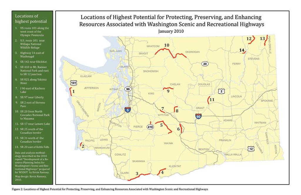
16 5. IDENTIFICATION OF LOCATIONS OF HIGHEST POTENTIAL Figure 1 represents Resource Planning Index values for each 1000 foot segment of the state Scenic and Recreational Highways. 10 The range of Index values along these roadways is 0 to 50. This data was then analyzed to isolate the segments that have the highest potential for preserving, and enhancing resources associated of Scenic and Recreational Highways. Roadway segments with clusters of cells in the top 40% of the Index range (30 or higher) were identified. These areas are represented in Figure 2. For ease of readability Figure 2 does not symbolize isolated cells with values of 30 or higher. For raw Index values throughout the Scenic and Recreational Highway System, including an accounting of all cells with values over a particular threshold, it is necessary to consult the original raster layer created for this analysis. 10 For map readability, the 1000-foot cells were expanded by one cell in each direction. To recover precise measurements for points along Scenic and Recreational Highways is will be necessary to return to the original GIS data. 11
17 6. LIMITATIONS OF THE RESOURCE PLANNING INDEX As with any statewide GIS analysis, this Index has a number of limitations that must be considered whenever it is used. First, the data available provide only an imperfect assessment of a location s opportunities for protecting, preserving, or enhancing resources associated with the state Scenic and Recreational Highways. For instance not all protected areas have equal viability as functioning ecosystems or habitats. Nor do all rivers, lakes, and wetlands have equal viability as riparian habitats. Yet this analysis treats all such places equally and with equal weight and assumes that these areas can equally benefit. Again, this may not necessarily be the case. However, it does provide a new data set and a method for benchmarking and tracking progress that can serve to support the visual assessments of scenic qualities conducted in the past. There are also issues around the completeness of statewide data. For instance, wildlife habitat corridor data is only available for four rare forest carnivores. There are many other species of concern for which habitat connectivity and corridor data is not currently available. Additional corridor identification work is in progress and the first GIS outputs will be available in late Likewise data regarding Priority Habitat Areas is shaped by the interests, priorities, and abilities of field biologists who conduct field surveys to collect data about such areas. There may be other habitats that are significantly impacted by scenic and recreational highways that are not considered in this analysis. Finally land use data that is collected at the county level may vary in accuracy, currency, and definitions. Fortunately, county level zoning data is only used to eliminate areas from consideration rather than boost Stewardship Index values. Therefore this particular limitation has only minor significance to overall Stewardship Index values There are also limitations to the Index as a measure of a location s potential for benefit. What the Index measures is simply the proximity or absence of particular features of interest. These features of interest are associated with various opportunities for protecting, preserving, or enhancing resources associated with the state Scenic and Recreational Highways. Therefore locations with higher Index values roughly measure the number of different opportunities that may be collocated in a particular cell or area. However, it is important to be clear that the Index does not necessarily measure or describe the priority of a location. 12
18 7. RECOMMENDED USE OF THE RESOURCE PLANNING INDEX There are a number of ways in which the Index could be used. The most appropriate use is as follows:! Identification of appropriate locations for focus The Index is a first pass assessment of locations where there may be a confluence of opportunities for protecting, preserving, or enhancing resources associated with the state Scenic and Recreational Highways. Therefore, if the goal of an investment is to address multiple opportunities at once, the Index can be used to roughly determine whether or not a location may be appropriate for this goal. As always, a local scale analysis of the location should assess exactly what opportunities exist there and whether a proposed project would actually provide the desired benefit or impact to the location. 13
19 14
20 15
Green Infrastructure Policies and Ordinances
 Green Infrastructure Policies and Ordinances October 23, 2013 By Karen Firehock, Green Infrastructure Center 2013 Georgia Urban Forest Council s 23 rd Annual Conference The mission of the nonprofit Green
Washington State s Growth Management Act
 Washington State s Growth Management Act A Framework for Smart Growth Anne Aurelia Fritzel, AICP Growth Management Services Department of Community, Trade and Economic Development The GMA A Framework for
FAQ S about Restoration Planning FROM THE Department of Ecology WEBSITE:
 FAQ S about Restoration Planning FROM THE Department of Ecology WEBSITE: http://www.ecy.wa.gov/programs/sea/sma/st_guide/smp/restoration/qanda.html Notations in parentheses are staff notes directing you
Development Reviews. An overview of the Commission s review process, primarily in Klickitat County. March 13, 2018
 Development Reviews An overview of the Commission s review process, primarily in Klickitat County March 13, 2018 Who should a landowner work with? Oregon Counties Washington Counties Multnomah County Land
systems is available on the Colorado Wetland Information Center (CWIC) website.
 website.") Colorado Natural Heritage Program Wetland Program Plan -- Dec 2015 Status Update and Addendum -- The Colorado Natural Heritage Program (CNHP) developed a Wetland Program Plan (WPP) in 2010 for the planning
Colorado Natural Heritage Program Wetland Program Plan -- Dec 2015 Status Update and Addendum -- The Colorado Natural Heritage Program (CNHP) developed a Wetland Program Plan (WPP) in 2010 for the planning
Conservation Corridor Planning and Green Infrastructure Themes
 Conservation Corridor Planning and Green Infrastructure Themes Prepared by the Green Infrastructure Center Inc. and the Northern Virginia Regional Commission February 22, 2011 Brief Overview Project Background
Overview of Southwestern Pennsylvania Commission s (SPC) 2040 Long Range Transportation Plan (LRTP)
 2040 Long Range Transportation Plan (LRTP)") Overview of Southwestern Pennsylvania Commission s (SPC) 2040 Long Range Transportation Plan (LRTP) Presented to Pennsylvania Agency Coordination Meeting May 27, 2015 Doug Smith & Ryan Gordon 1 Southwestern
Overview of Southwestern Pennsylvania Commission s (SPC) 2040 Long Range Transportation Plan (LRTP) Presented to Pennsylvania Agency Coordination Meeting May 27, 2015 Doug Smith & Ryan Gordon 1 Southwestern
WASHINGTON COUNTY OREGON
 WASHINGTON COUNTY OREGON LONG RANGE PLANNING DIVISION North Bethany Subarea Stream Corridors: Existing Regulations In Oregon, there is a distinct difference between the land use rules that apply in rural
STEWARDSHIP OF LONG ISLAND SOUND S ECOLOGICAL AND RECREATIONAL RESOURCES
 STEWARDSHIP OF LONG ISLAND SOUND S ECOLOGICAL AND RECREATIONAL RESOURCES Robin Kriesberg, Save the Sound, Inc. Thomas Halavik, US Fish and Wildlife Service Coastal Program An Initiative to Identify, Protect
THREE-STEP DESIGN PROCESS FOR OPEN SPACE SUBDIVISIONS
 00216106.DOC NMA/RRK 1/30/14 THREE-STEP DESIGN PROCESS FOR OPEN SPACE SUBDIVISIONS Open space subdivisions, sometimes called cluster developments, maintain a significant portion of a development site in
Map Development 5/15/2012. New Virginia Modeling Tools
 Regional Green Infrastructure Base Map Development 5/15/2012 RRRC Land Use & Environment Committee New Virginia Modeling Tools VA Natural Landscape Assessment Forest Habitats Cultural Model Historic Resources
NJ Habitat Connectivity Initiative
 NJ Habitat Connectivity Initiative Full Working Group Update #1 Spotted Salamander Crossing Road in Northern NJ Wildlife Habitat Connectivity Initiative A strategic plan to reconnect New Jersey s landscape
Blue/Green Infrastructure Study Accomack County, VA
 Blue/Green Infrastructure Study Accomack County, VA Draft Asset Maps March 8-9, 2010 Green Infrastructure Center, Inc. 2 Overview What is Green and Blue Infrastructure Project Timeline & Tasks Literature
National Association of Conservation Districts. Kris Hoellen Vice President, Sustainable Programs The Conservation Fund September 19, 2013
 National Association of Conservation Districts Kris Hoellen Vice President, Sustainable Programs The Conservation Fund September 19, 2013 Our Mission The Conservation Fund forges partnerships to conserve
Town of Peru Comprehensive Plan Executive Summary
 Town of Peru Comprehensive Plan Executive Communities that plan grow by choice, not by chance. A plan makes growth thoughtful, understandable, and predictable. A plan shows that a community is managing
Parks, Trails, and Open space Element
 Parks, Trails, and Open space Element Parks, Trails, and Open Space element Parks, Recreation, and Open Space are important components of the quality of life desired by the residents of Elk Grove. This
Conservation Corridor Base and Thematic Maps
 Conservation Corridor Base and Thematic Maps August 20, 2010 This project is funded in part by the Virginia Coastal Zone Management Program at the Department of Environmental Quality through Grant #NAO9NOS4190163
ELIGIBILITY CRITERIA CHECKLIST OPEN SPACE CLASSIFICATION
 THURSTON COUNTY DEVELOPMENT SERVICES OPEN SPACE TAX PROGRAM ELIGIBILITY CRITERIA CHECKLIST OPEN SPACE CLASSIFICATION Use this checklist to help you determine whether your property is eligible for open
PURPOSE: The purpose is to provide commercial facilities in the Vancouver and Clark County vicinity.
 US Army Corps of Engineers Seattle District Joint Public Notice Application for a Department of the Army Permit and a Washington Department of Ecology Water Quality Certification and/or Coastal Zone Management
Green Infrastructure. by Karen Engel, NYS DEC. NYS Department of Environmental Conservation
 Green Infrastructure by Karen Engel, NYS DEC What is Green Infrastructure? For some it s all about water Green Infrastructure techniques use soils and vegetation to infiltrate, evapotranspirate, and/or
When planning stormwater management facilities, the following principles shall be applied where possible.
 2.0 Principles When planning stormwater management facilities, the following principles shall be applied where possible. 2.0.1 Drainage is a regional phenomenon that does not respect the boundaries between
Parks, Trails, and Open Space Element
 P arks, Recreation, and Open Space are important components of the quality of life desired by the residents of Elk Grove. This Element of the General Plan addresses the City s goals, policies, and actions
This page intentionally blank.
 This page intentionally blank. Parks, Recreation, and Open Space Chapter Relationship to Vision Vision Parks, Recreation and Open Space Chapter Concepts County Government. County government that is accountable
Master Plan Objectives and Policies
 Master Plan Objectives and Policies Introduction This chapter identifies the Park issues and recommended policies established by this Master Plan. The issues were identified through meetings with staff,
Preface. Erie. Scranton. Allentown. Pittsburgh. Harrisburg. Philadelphia
 The Southern Alleghenies Region The Southern Alleghenies Region spans the Laurel Highlands and Allegheny Front in the west across the Appalachians to the east. It is comprised of Blair, Bedford, Cambria,
Public Review Draft Oceanside Subarea Habitat Conservation Plan/ Natural Communities Conservation Plan
 Oceanside Subarea Habitat Conservation Plan/ Natural Communities Conservation Plan Prepared for City of Oceanside Planning Department 300 N. Coast Highway Oceanside, CA 92054 Prepared by Ogden Environmental
Shoreline Master Program Town of La Conner, Washington
 Shoreline Master Program Town of La Conner, Washington Department of Ecology approval effective Adopted September 24, 2013 by Town of La Conner Ordinance No.1106 Amended May 13, 2014 by Town of La Conner
I. STAFF POLICY RECOMMENDATIONS. The following RMP policy strategies are proposed by staff in support of a Scenic Resource Protection Program:
 Policy Consideration: Scenic Resource Protection Program Status: For Consideration by the Highlands Council at September 14, 2006 Work session Date: September 12, 2006 I. STAFF POLICY RECOMMENDATIONS The
Chapter 5: Natural Resources and Environment
 NATURAL RESOURCES AND ENVIRONMENT 5-1 5 Chapter 5: Natural Resources and Environment BACKGROUND AND INTENT Urban expansion represents the greatest risk for the future degradation of existing natural areas,
Minnesota Department of Natural Resource - Natural Resource Guidance Checklist Conserving Natural Resources through Density Bonuses
 Minnesota Department of Natural Resource - Natural Resource Guidance Checklist Conserving Natural Resources through Density Bonuses NRDB Why Use Density Bonuses & This Checklist Local units of government
Executive Summary. Essential Connectivity Map (Figure ES-1)
") Executive Summary The California Department of Transportation (Caltrans) and California Department of Fish and Game (CDFG) commissioned the because a functional network of connected wildlands is essential
Executive Summary The California Department of Transportation (Caltrans) and California Department of Fish and Game (CDFG) commissioned the because a functional network of connected wildlands is essential
Great Lakes Conservation Blueprint for Terrestrial Biodiversity on the Canadian Shield
 Great Lakes Conservation Blueprint for Terrestrial Biodiversity on the Canadian Shield Bonnie L. Henson 1, Kara E. Brodribb 2 and John L. Riley 3 1 Ontario Ministry of Natural Resources 2,3 The Nature
Table of Contents TABLE OF CONTENTS SECTION TITLE PAGE
 TABLE OF CONTENTS SECTION TITLE PAGE 1 INTRODUCTION AND OVERVIEW 1-1 1.1 Purpose and Need 1-1 1.2 Goals and Objectives 1-3 1.3 Overview of the Planning Process 1-5 1.4 Federal and State Requirements and
Potential Solutions to Transportation-Wildlife Conflicts An Overview. Tony Clevenger WTI Montana State University
 Potential Solutions to Transportation-Wildlife Conflicts An Overview Tony Clevenger WTI Montana State University Effects on wildlife Habitat loss Wildlife mortality Decrease habitat quality Habitat fragmentation
CONSERVATION ELEMENT GOALS, OBJECTIVES, AND POLICIES
 CONSERVATION ELEMENT GOALS, OBJECTIVES, AND POLICIES Goal 4 To conserve, manage, appropriately use and protect the natural resources of the City ensuring continued resource availability and environmental
Outfall Reconnaissance Inventory & Stream Assessment
 CITY OF TUMWATER Outfall Reconnaissance Inventory & Stream Assessment City of Tumwater 555 Israel Road SW Tumwater, WA 98501 ACKNOWLEDGEMENTS City of Tumwater Outfall Reconnaissance Inventory and Stream
Virginia DCR- Natural Heritage Program. Tools for Linking Conservation and Transportation Planning
 Virginia DCR- Natural Heritage Program Tools for Linking Conservation and Transportation Planning November 9, 2009 MISSION: to conserve Virginia's biodiversity through statewide biological inventory, protection,
Green Infrastructure. NYS Department of Environmental Conservation
 Green Infrastructure Green infrastructure is an interconnected network of natural areas and open spaces that sustains ecosystems. Benedict, M.A. and E.T. McMahon. 2006. Green Infrastructure Linking Landscapes
Location. Need GOAL 14 URBAN GROWTH BOUNDARY. Urban Planning in Oregon 7/8/2015
 Urban Planning in Oregon June 24, 2015 Redmond, Oregon Gordon Howard, DLCD Urban Planning Specialist GOAL 14 URBAN GROWTH BOUNDARY To provide for an orderly and efficient transition from rural to urban
HAZARD MITIGATION GOALS AND OBJECTIVES
 SEWRPC Community Assistance Planning Report No. 282, 2nd Edition CITY OF MILWAUKEE ALL HAZARDS MITIGATION PLAN UPDATE Chapter IV HAZARD MITIGATION GOALS AND OBJECTIVES [NOTE: Throughout this plan update
SQUAMISH 2010 AND BEYOND COMMUNITY VISION
 Our plan has been imagined and created to be both pragmatic and visionary. At the core of the strategy is a consideration of the highway s role and its impact on the community. First and foremost in creating
TOWN OF SPRINGFIELD, NEW HAMPSHIRE
 TOWN OF SPRINGFIELD, NEW HAMPSHIRE NATURAL RESOURCES INVENTORY EXECUTIVE SUMMARY March 2008 Prepared by: Watershed to Wildlife, Inc. Natural Resource Consultants 42 Mill Street, Suite 3 Littleton, NH 03561
7.0 SOCIAL, ECONOMIC, AND ENVIRONMENTAL ISSUES
 7.0 SOCIAL, ECONOMIC, AND ENVIRONMENTAL ISSUES The following list of social, economic, and environmental issues have been identified based on a preliminary inventory of resources in the project area, an
Brice Prairie Master Plan
 Brice Prairie Master Plan Town of Onalaska Community Meeting #1 Sand Lake Elementary School January 28, 2006 9 am 11 am Agenda Background What is a Master Plan? Brice Prairie Capacity Reports Starter Ideas
Rural Land Use Designations Kittitas County December 6, 2007 Draft
 KITTITAS COUNTY COMMUNITY DEVELOPMENT SERVICES 411 N. Ruby St., Suite 2, Ellensburg, WA 98926 CDS@CO.KITTITAS.WA.US Office (509) 962-7506 Fax (509) 962-7682 Rural Land Use Designations Kittitas County
Tackling Difficult SEQR Topics
 Presented by Nan Stolzenburg AICP CEP and Don Meltz AICP Tackling Difficult SEQR Topics COMMUNITY CHARACTER, HISTORIC/ARCHAEOLOGICAL RESOURCES & HABITATS/ENDANGERED SPECIES Training Agenda Introductions
Erik Rundell, Project Manager
 Erik Rundell, Project Manager M.U.R.P., Portland State University Certificate, Commercial Real Estate, University of Washington Graduate Certificate, GIS, University of Wisconsin-Madison B.A. Geography,
Riparian Buffer on the Bushkill Creek. Policies
 Riparian Buffer on the Bushkill Creek Riparian buffers provide numerous benefits to landowners and the community by protecting groundwater recharge areas, providing flood control, providing stormwater
CLACKAMAS COUNTY ZONING AND DEVELOPMENT ORDINANCE
 704 RIVER AND STREAM CONSERVATION AREA (RSCA) 704.01 PURPOSE Section 704 is adopted to: A. Maintain the integrity of the rivers and streams in the County by minimizing erosion, promoting bank stability,
Your town s subdivision or land use ordinance standards should reference the following street standards, for example:
 Your town s subdivision or land use ordinance standards should reference the following street standards, for example: Streets shall be designed to move traffic safely and in a way that minimizes environmental
HOUSING ELEMENT GOALS, OBJECTIVES, AND POLICIES
 HOUSING ELEMENT GOALS, OBJECTIVES, AND POLICIES Goal 6 Maintain and enhance the supply of decent, safe, energy efficient and affordable housing and maximize viable options and opportunities for present
Steering Committee 3. September 17, :30-7:30pm. Welcome.
 Steering Committee 3 September 17, 2015 5:30-7:30pm Welcome DOG RIVER www.makingwatershedswork.org Agenda 1. Welcome 2. Scientific Research: Water Quality 3. Current and Relevant Planning 4. Community
Chesapeake Bay Critical Area Conservation Plan
 The Maryland-National Capital Park and Planning Commission Prince George s County Planning Department Development Review Division 301-952-3530 Note: Staff reports can be accessed at www.mncppc.org/pgco/planning/plan.htm.
DRAFT MAP AMENDMENT FLU 04-4
 DRAFT MAP AMENDMENT FLU 04-4 SW 24 TH AVENUE ROADWAY CORRIDOR The University of Florida participates with the Metropolitan Transportation Planning Organization (MTPO) in its responsibilities for the continuing,
CAO Update Status Work continues on products: Draft ordinance BAS report CAO process summary (2002 to present) Comprehensive e Plan policy review Some
 Comprehensive e Plan policy review Some") Critical Areas Ordinance Update Wetlands Andrew Deffobis Jeremy Davis Cynthia Wilson Thurston County Planning April 6, 2011 CAO Update Status Work continues on products: Draft ordinance BAS report CAO
Critical Areas Ordinance Update Wetlands Andrew Deffobis Jeremy Davis Cynthia Wilson Thurston County Planning April 6, 2011 CAO Update Status Work continues on products: Draft ordinance BAS report CAO
Planning Considerations for Wildlife Passage in Urban Environments. (Prepared by Tony Clevenger, PhD)
") Scope Planning Considerations for Wildlife Passage in Urban Environments. (Prepared by Tony Clevenger, PhD) As urban populations grow and expand into rural areas there are changes in land use patterns
Scope Planning Considerations for Wildlife Passage in Urban Environments. (Prepared by Tony Clevenger, PhD) As urban populations grow and expand into rural areas there are changes in land use patterns
BLOOMSBURY BOROUGH. Regional Master Plan Overlay Zone Designation. 1 inch = 0.28 miles. Zone. Sub-Zone FRANKLIN TOWNSHIP GREENWICH TOWNSHIP
 Regional Master Plan Overlay Zone Designation Zone Protection Lakes Greater Than 10 acres Conservation Existing Community Sub-Zone Existing Community Environmentally Constrained Conservation Environmentally
Toronto Complete Streets Guidelines
 Toronto Complete Streets Guidelines 108 110 7.1 Green Infrastructure Design Principles 112 7.2 Context-Sensitive Green Streets 114 7.3 Key Green Street Elements Green infrastructure refers to natural and
COMMUNITY DESIGN. GOAL: Create livable and attractive communities. Intent
 COMMUNITY DESIGN Intent An attractive, well-designed County will attract quality development, instill civic pride, improve the visual character of the community, and create a strong, positive image for
Los Angeles River-Arroyo Seco Confluence Restoration Vision Plan. Professor Meredith McKenzie, JD Urban & Regional Planning Dept Cal Poly Pomona
 Los Angeles River-Arroyo Seco Confluence Restoration Vision Plan Professor Meredith McKenzie, JD Urban & Regional Planning Dept Cal Poly Pomona The Los Angeles River Watershed Arroyo Seco Watershed Map
Staff will be providing an overview of the project need, purpose and intent for consideration as part of the Amendment cycle.
 Agenda Item D-2 City of Tacoma Planning and Development Services To: Planning Commission From: Stephen Atkinson, Planning Services Division Subject: Open Space Corridors Project Meeting Date: March 1,
RECREATION AND OPEN SPACE ELEMENT GOALS, OBJECTIVES, AND POLICIES
 RECREATION AND OPEN SPACE ELEMENT GOALS, OBJECTIVES, AND POLICIES Goal 7 To provide park facilities, recreation programs, and open space resources that are safe, adequate, and accessible to all City residents,
Roads and Ecological Integrity. Best Management Practices. September 2016: Version 1.1
 Roads and Ecological Integrity Best Management Practices September 2016: Introduction Most of the pressures on the ecological integrity of provincial parks can be linked to, or are made worse by roads.
Chapter WAC SHORELINE MASTER PROGRAM GUIDELINES. Table of Contents WAC AUTHORITY, PURPOSE AND EFFECTS OF GUIDELINES.
 Chapter 173-26 WAC SHORELINE MASTER PROGRAM GUIDELINES Table of Contents WAC 173-26-171 AUTHORITY, PURPOSE AND EFFECTS OF GUIDELINES. 5 WAC 173-26-176 GENERAL POLICY GOALS OF THE ACT AND GUIDELINES FOR
The City shall enhance and improve the accessibility of parks and recreational facilities while protecting their quality. by:
 GOALS, OBJECTIVES AND POLICIES GOAL 1: To provide open space and recreation as an essential element needed for the betterment of the City s character and quality of urban life. The City shall plan for
Community Conservation Workshop. Saranac River Basin Communities
 Community Conservation Workshop Saranac River Basin Communities 2 Community Conservation Program Welcome! We have designed a Community Conservation Program that listens to the needs of community members.
Arkansas River Corridor
 Planning for Access Welcome to the Access Project. This project is a recreational planning effort in response to an interest by regional communities along the Arkansas River corridor. The project plan
Shoreland Zoning. Kay Lutze Shoreland Zoning Policy Coordinator
 Shoreland Zoning Kay Lutze Shoreland Zoning Policy Coordinator Kay.Lutze@wisconsin.gov Purposes of shoreland zoning include Prevent and control water pollution Protect spawning grounds, fish and aquatic
ST. MARY S SOIL CONSERVATION DISTRICT (SMSCD) AND DPW&T CONCEPT EROSION AND SEDIMENT CONTROL AND STORMWATER MANAGEMENT GUIDELINES AND CHECKLIST
 AND DPW&T CONCEPT EROSION AND SEDIMENT CONTROL AND STORMWATER MANAGEMENT GUIDELINES AND CHECKLIST") St. Mary s Soil Conservation District 26737 Radio Station Way, Suite B Leonardtown, MD 20650 Phone: 301-475-8402 ext. 3 Fax: 301-475-8391 www.stmarysscd.com St. Mary s County Government Department of Public
St. Mary s Soil Conservation District 26737 Radio Station Way, Suite B Leonardtown, MD 20650 Phone: 301-475-8402 ext. 3 Fax: 301-475-8391 www.stmarysscd.com St. Mary s County Government Department of Public
Arlington, Virginia is a worldclass
 EXECUTIVE S U M M A RY Arlington maintains a rich variety of stable neighborhoods, quality schools and enlightened land use policies, and received the Environmental Protection Agency s highest award for
Policy & Procedure Effective Date: Parks Department Page of
 City of Arvada Policy & Procedure Effective Date: Parks Department Page of TITLE: City of Arvada Prairie Dog Habitat Plan APPROVAL: PURPOSE: To establish a plan for the preservation of black-tailed prairie
Growth Management Planning in the Central Puget Sound Region. Today s Presentation. Puget Sound Region. New Partners for Smart Growth
 Growth Management Planning in the Central Puget Sound Region New Partners for Smart Growth Denver, CO January 2006 Today s Presentation Regional growth management in central Puget Sound, WA Regional geographies
Middle Mississippi River. Regional Corridor
 Middle Mississippi River St. Louis District Regional Corridor Lessons Learned from a Collaborative Planning Study Brian Johnson US Army Corps of Engineers 12 th Biennial Governor s Conference on the Management
COMMUNITY ENVIRONMENTAL MANAGEMENT
 COMMUNITY ENVIRONMENTAL MANAGEMENT CEM HANDBOOK FOR COMMUNITY CONSERVATION PLANNING ----- Draft ----- Prepared by the CENTER FOR COMMUNITY ENVIRONMENTAL MANAGEMENT in association with the NEW YORK STATE
Aquatic, Terrestrial and Landscape Conservation Design Tools and Products of the North Atlantic LCC
 Aquatic, Terrestrial and Landscape Conservation Design Tools and Products of the North Atlantic LCC Scott Schwenk Science Coordinator, North Atlantic LCC Chesapeake Bay FWS Partners Meeting Annapolis,
The Benefits and Challenges Associated with Green Infrastructure Practices
 The Benefits and Challenges Associated with Green Infrastructure Practices Thomas M. Evans ASLA, LEED AP Regional Green Infrastructure Design Services Director OWEA Technical Conference, June 20, 2013
DISCUSSION TOPIC: ST JOHNS RIVER & ITS TRIBUTARIES (BPII) 2030 COMPREHENSIVE PLAN POLICES AND REGULATORY FRAMEWORK
 2030 COMPREHENSIVE PLAN POLICES AND REGULATORY FRAMEWORK") DISCUSSION TOPIC: ST JOHNS RIVER & ITS TRIBUTARIES (BPII) 2030 COMPREHENSIVE PLAN POLICES AND REGULATORY FRAMEWORK St. John s River & Its Tributaries Issue Summary: The St. Johns River is an important
DISCUSSION TOPIC: ST JOHNS RIVER & ITS TRIBUTARIES (BPII) 2030 COMPREHENSIVE PLAN POLICES AND REGULATORY FRAMEWORK St. John s River & Its Tributaries Issue Summary: The St. Johns River is an important
PROJECT BACKGROUND. Preliminary Design Scope and Tasks
 PROJECT BACKGROUND Preliminary Design Scope and Tasks The purpose of this Study is the development of preliminary designs for intersection improvements for Trunk Highway (TH) 36 at the intersections of
RECREATION, OPEN SPACE AND GREENWAYS ELEMENT GOALS, OBJECTIVES, AND POLICIES
 RECREATION, OPEN SPACE AND GREENWAYS ELEMENT GOALS, OBJECTIVES, AND POLICIES GOAL R-1: DEVELOP A RECREATION, OPEN SPACE AND GREENWAYS SYSTEM AS AN INTEGRAL COMPONENT OF AN OVERALL, COUNTY-WIDE ECONOMIC
Florida Forever Conservation Needs Assessment Overview Maps
 Florida Forever Conservation Needs Assessment Overview Maps Prepared by Florida Natural Areas Inventory, The maps in this document are derived from the Florida Forever Conservation Needs Assessment, an
INTRODUCTION Key Issues and Findings Goals, Objectives, and Policies - Natural Resources - Map M18 - Environmental Resources
 Natural, Environmental, Cu INTRODUCTION This Element provides policies related to the preservation and protection of the Centre Region s natural, environmental, cultural, and historic resources. This Element
Decision Notice. Proposed Action
 Decision Notice Paving Weld County Road 105 USDA Forest Service Arapaho and Roosevelt National Forest and Pawnee National Grassland Pawnee National Grassland Ranger District Weld County, Colorado November
City of Richland Comprehensive Plan: Integrated Non-project Final Environmental Impact Statement
 City of Richland Comprehensive Plan: Integrated Non-project Final Environmental Impact Statement September 12, 2017 Prepared for: City of Richland Prepared by: Oneza & Associates With assistance from:
TO: Port of Orcas FROM: Tina Whitman, Science Director SUBJECT: Master Plan Update DATE: September 7, 2018
 TO: Port of Orcas FROM: Tina Whitman, Science Director SUBJECT: Master Plan Update DATE: September 7, 2018 Friends of the San Juans appreciates the opportunity to provide input to the Port of Orcas Master
COLVER ROAD INDUSTRIAL CONCEPT PLAN
 COLVER ROAD INDUSTRIAL CONCEPT PLAN A CONCEPTUAL LAND USE AND TRANSPORTATION PLAN FOR TA-4 AN URBAN RESERVE AREA OF THE CITY TALENT City of Talent Adopted by City Council Resolution No., June, 2015 PART
4. What are the goals of the Kawarthas, Naturally Connected project? 7. What are watersheds and why are they being used as the project boundaries?
 Frequently Asked Questions (FAQs) 1. What are Natural Heritage Systems (NHS)? 2. Why are they important? 3. Which areas of the province have undertaken NHS projects? 4. What are the goals of the Kawarthas,
Camden SMART Initiative Stormwater Management and Resource Training
 Camden SMART Initiative Stormwater Management and Resource Training www.camdensmart.com Camden s Struggle with Stormwater 1 The City of Camden is served by a combined sewer system, which uses the same
The Landscape Project. New Jersey Department of Environmental Protection Division of Fish and Wildlife Endangered and Nongame Species Program
 The Landscape Project New Jersey Department of Environmental Protection Division of Fish and Wildlife Endangered and Nongame Species Program New Jersey is One of the smallest states in the country Yet
Sustainable Waterfront Redevelopment Case Study: Seattle, Washington. By Nicole Faghin, LEED AP
 Sustainable Waterfront Redevelopment Case Study: Seattle, Washington By Nicole Faghin, LEED AP CONTENTS Introduction to AECOM Introduction to Puget Sound Sustainable Redevelopment of Seattle s Waterfront
CHAPTER 4 FUTURE LAND USE AND URBAN SERVICES DISTRICTS
 CHAPTER 4 FUTURE LAND USE AND URBAN SERVICES DISTRICTS Introduction This chapter discusses how Benzie County should grow and change in the future. A community can grow and change in many different ways.
TOWNSHIP OF LOGAN SOIL & FILL IMPORTATION AND PLACEMENT APPLICATION SUBMITTAL CHECKLIST
 TOWNSHIP OF LOGAN SOIL & FILL IMPORTATION AND PLACEMENT APPLICATION SUBMITTAL CHECKLIST Applications: 5 copies of application - Applicant will reproduce the copies at his/her costs. The Township Clerk
Ecosystem Restoration Business Line Budgeting A Systems Approach
 Ecosystem Restoration Business Line Budgeting A Systems Approach Laura Orr (NWS), Shawn Phillips (MVM), Greg Steele (NAO) Introduction Chesapeake Bay Bridge Mouth of Mississippi River Bonneville Dam Fish
Community Conservation Workshop. Lake Placid
 Community Conservation Workshop Lake Placid 2 Community Conservation Program Welcome! We have designed a Community Conservation Program that listens to the needs of community members. We are conducting
City of Missoula and Missoula County Open Space Planning Open House
 City of Missoula and Missoula County Open Space Planning Open House FEBRUARY 6, 2018 The following slides contain the display board content from the open house. Please use boards to answer questions in
General Manager of Planning, Urban Design and Sustainability
 ADMINISTRATIVE REPORT Report Date: May 2, 2017 Contact: Katherine Isaac Contact No.: 604.873.7167 RTS No.: 10847 VanRIMS No.: 08-2000-20 Meeting Date: May 16, 2017 TO: FROM: SUBJECT: Vancouver City Council
The West Vaughan Employment Area Secondary Plan Policies
 Part 2: The West Vaughan Employment Area Secondary Plan Policies 2.1 General Policies It is the policy of Council: 2.1.1. That the West Vaughan Employment Area (the WVEA), identified on Schedule 1, will
2014 South Atlantic LCC
 2014 South Atlantic LCC Annual Report 1 Allie Stewart, U.S. FWS The South Atlantic LCC s 2014 Annual Report this year of progress and accomplishments is dedicated to South Atlantic LCC Coordinator, Ken
SUSTAINABILITY PLAN OTTAWA COUNTY PARKS AND RECREATION COMMISSION FALL 2017
 SUSTAINABILITY PLAN OTTAWA COUNTY PARKS AND RECREATION COMMISSION FALL 2017 Table of Contents Introduction Natural Resources Quality of Life Community Continuing the Mission Sustainability Measuring Sustainability
1.16 million KM 2 5 States, 2 Provinces Integrated Partnerships with neighboring LCCs, NW and NC Climate Science Centers, PNW
 GNLCC Goal: Coordinate, facilitate, promote and add value to large landscape conservation to build resource resilience in the face of climate change and other landscape level stressors through: Support
Westport Master Plan. Town of Westport. Master Plan Master Plan Update Committee. Westport, Massachusetts
 Town of Westport Master Plan 2004 Master Plan Update Committee Westport, Massachusetts Open Space and Recreation 5-1 Table of Contents Table of Contents... i List of Tables... ix List of Figures... ix