Adoption of the Rosslyn Sector Plan Site Plan Review Committee (SPRC) Meeting October 26, 2015
|
|
|
- Beverley Sutton
- 5 years ago
- Views:
Transcription


1 Adoption of the Rosslyn Sector Plan Site Plan Review Committee (SPRC) Meeting October 26, 2015


2 Rosslyn Sector Plan Introduction Adopted by the County Board in July 2015 Reflects the new long range planning vision and guidance for the Rosslyn Coordinated Redevelopment District Addresses Key Subject Areas: Urban Design Building Height and Form Transportation Public Open Space 2


3 Project Schedule The Rosslyn Vision 3
4 Illustrative Concept Plan Alternate site layout possibility for Rosslyn Plaza Park A B C D E F Two-way Streets 18 th Street Extension Metro Plaza New Ped/Bike Bridge Connections Gateway Park Freedom Park 4


5 Illustrative Concept Plan Alternate site layout possibility for Rosslyn Plaza Park G H I J K L 18 th Street Corridor of Parks and Plazas Rosslyn Plaza Park Esplanade Observation Deck Peaks and Valleys Improved pedestrian and bicycle network M Land Use Goals 5
6 Project Schedule A Plan for Significant Growth in Rosslyn s future Potential Illustrative Development Characteristics (square feet) Rosslyn Sector Plan RCRD* Modeled Peaks and Valleys Land Use Ultimate Build Out Building Use Existing Existing/ Approved New Construction Demolitions Build Out Office 7,903,000 9,582,000 7,294,000 (5,017,000) 11,859,000 Retail 426, , ,000 (346,000) 698,000 Residential 635,000 1,971,000 4,193,000 (297,000) 5,867,000 Hotel 681, , ,000 (478,000) 852,000 Other 119, ,000 0 (71,000) 30,000 TOTAL 9,764,000 12,969,000 12,545,000 (6,209,000) 19,306,000 * 1555 Wilson Blvd. not included in these figures

7 Project Schedule Sector Plan Guidance Specific to Rosslyn Plaza 7

8 Project Schedule Street and Block Pattern Transportation 8


9 Transportation Street/Travel Lane Change or 18 th Street Corridor Rosslyn Plaza Conversion of One-way to Two-way Streets 9


10 Project Schedule Transportation Street Classification and Typologies Sidewalk Widths 10

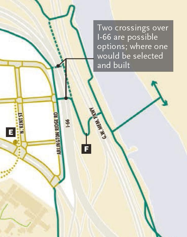
11 Project Schedule Transportation Pedestrian Facilities Bicycle Facilities alt. route alt. route 11


12 Project Schedule Transportation * *Segments of 18 th Street could also be designed/built as a curb-less environment, when deemed appropriate 12

13 Project Schedule Transportation Approximate build-to-line if Rosslyn Plaza Park is located on Kent Street 13
14 Project Schedule Transportation 14

15 Public Parks and Open Spaces Public Parks and Open Space alt. route 2 Esplanade 3 Freedom Park 7 Central Place Plaza 8 Rosslyn Plaza Park 9 Dark Star Park 13 Mt. Vernon Trail 25 Waterview Terrace 15


16 Open Space Rosslyn Plaza Park Alternate site layout possibility for Rosslyn Plaza Park 16

17 Open Space Rosslyn Plaza Park 17

18 Open Space Rosslyn Plaza Park 18

19 Open Space Rosslyn Plaza Park 19
20 Open Space Rosslyn Plaza Park Criteria The Rosslyn Sector Plan provides two potential locations for Rosslyn Plaza Park For either location, the sector plan calls for the following criteria to be met: o Provide a consolidated, primary open space of about 1 acre in size; o Accommodate a balanced mix of activities, including recreation, multiuse green space, and retail opportunities; o Building form and design should support the balanced mix of activities, including active recreation, and maximize sunlight opportunities on the public open space during peak usage times; o Provide visual and physical connectivity between the primary open space and 18th Street, the potential bridge connection towards Theodore Roosevelt Island, the Esplanade and other key routes to the space; o Maintain a generous view corridor down 18th Street from Kent Street toward the esplanade; o Buildings located in proximity to the open space and 18 th Street should be signature buildings that respond to the surrounding open space and celebrate the view terminus. 20


21 Open Space--Esplanade Approximate build-to-line if Rosslyn Plaza Park is located on Kent Street 21

22 Building Heights Building Heights 22

23 Building Heights Observation Tower Views 23


24 Project Schedule Urban Design Service and Parking Access Tower Orientation 24


25 Project Schedule Ground Level Uses Ground Level Uses Exterior Design Principles apply to Red, Gold, and Blue Streets Interior Design Principles also apply to Red and Gold Streets 25
26 Discussion 26
GOODY CLANCY WITH KITTELSON & ASSOCIATES RHODESIDE & HARWELL FARR ASSOCIATES W-ZHA
 1 1. Welcome 5 min. 2. Follow-up from 9/22 / Corridor of Light, ground floor uses 20 min. 3. Small on-site open spaces / Overview of types, identities 15 min. 4. Rosslyn Plaza Park / Rosslyn Plaza PDSP
Realizing Rosslyn: a new era of opportunity GOODY CLANCY WITH KITTELSON & ASSOCIATES RHODESIDE & HARWELL FARR ASSOCIATES W-ZHA
 Realizing Rosslyn: a new era of opportunity 1 AGENDA 1. Welcome 5 min. 2. Overview 5 min. 3. Emerging Recommendations A. Building Height and Massing 40 min. B. 18 th Street Corridor Details 15 min. C.
Rosslyn Plaza PDSP (SP #422) SPRC Staff Presentation
 SPRC Staff Presentation") Rosslyn Plaza PDSP (SP #422) SPRC Staff Presentation ote Guiding Principles included in this document are taken from the latest working draft of the Guiding Principles dated. The illustrations included
Rosslyn Plaza PDSP (SP #422) SPRC Staff Presentation ote Guiding Principles included in this document are taken from the latest working draft of the Guiding Principles dated. The illustrations included
W i l s o n B o u l e v a r d & K e y B o u l e v a r d
 1 4 0 1 W i l s o n B o u l e v a r d & 1 4 0 0 K e y B o u l e v a r d R o s s l y n, A r l i n g t o n C o u n t y, V i r g i n i a S i t e P l a n R e v i e w C o m m i t t e e M e e t i n g # 8 0 4.
Rosslyn Sector Plan Implementation
 DEPARTMENT OF COMMUNITY PLANNING, HOUSING AND DEVELOPMENT Planning Division #1 Courthouse Plaza, 2100 Clarendon Boulevard, Suite 700 Arlington, VA 22201 TEL 703.228.3525 FAX 703.228.3543 www.arlingtonva.us
Realizing Rosslyn: a new era of opportunity GOODY CLANCY WITH KITTELSON & ASSOCIATES RHODESIDE & HARWELL FARR ASSOCIATES W-ZHA
 Realizing Rosslyn: a new era of opportunity PRESENTATION OUTLINE 2 3 4 Building tops tour: what we observed 5 Building height/form and urban design: interrelated elements 6 WORK SEQUENCE 7 Building height/form
CRYSTAL CITY BLOCK PLAN # CCBP- G 1
 CRYSTAL CITY BLOCK PLAN # CCBP- G 1 BLOCK G (Metro Market Square block) Long Range Planning Committee Meeting #3 April 2, 2018 1 1. Tonight s Agenda 1. Introductory Remarks (Jane Siegel) 2. Follow-up from
ARLINGTON COUNTY, VIRGINIA
 ARLINGTON COUNTY, VIRGINIA County Board Agenda Item Meeting of March 20, 2007 SUPPLEMENTAL REPORT #2 Additional and Revised Information DATE: March 20, 2007 SUBJECT: Request to Advertise Public Hearings
SP #94, AREP Rosslyn City Center
 SP #94, AREP Rosslyn City Center 1700 & 1810 N. Moore Street Department of Community Planning, Housing, and Development County Board July 15, 2017 1 19 th Street N. Wilson Boulevard Location Rosslyn City
Seneca Meadows. Block 4 Locate office, technology, and medical development adjacent to I Screen views of garage structures from I-270.
 Seneca Meadows Seneca Meadows has an industrial park in its southern end and a mixed-use employment area planned for the north end. The district benefits from extensive I-270 visibility, stream valley
Appendix I ARLINGTON COUNTY SECTOR PLANS SUMMARY RECOMMENDATIONS RELATED TO PUBLIC SPACES
 Appendix I ARLINGTON COUNTY SECTOR PLANS SUMMARY RECOMMENDATIONS RELATED TO PUBLIC SPACES The County has developed Sector Plans for various planning areas within Arlington County s Metro corridors. Following
GOODY CLANCY WITH KITTELSON & ASSOCIATES RHODESIDE & HARWELL FARR ASSOCIATES W-ZHA
 1 1. Welcome / Subcommittee introductions, role, goals, Realize Rosslyn process overview 10 min. 2. Existing parks/open space context 10 min. 3. The Rosslyn Plan framework / Parks & open space overview
CRYSTAL CITY BLOCK PLAN # CCBP- G 1 DRAFT
 CRYSTAL CITY BLOCK PLAN # CCBP- G 1 DRAFT BLOCK G (Metro Market Square block) Long Range Planning Committee Meeting January 29, 2018 1 1. Introduction 2 1. LRPC Meeting Purpose Review of proposed Crystal
Part 2 Common Elements
 WHITE FLINT SECTOR PLAN Round Table Discussion: Part 2 Common Elements October 8, 2007 The M-NCPPC 1 Role Regional Marketplace North Bethesda s Downtown with a Conference Center District The M-NCPPC 2
Courthouse Square Planning & Urban Design Study. Courthouse Square Working Group #13 October 15, 2014
 Courthouse Square Planning & Urban Design Study Courthouse Square Working Group #13 October 15, 2014 1 Courthouse Square Process Working Group Community Courthouse Square Advisory Groups & Civic Associations
Isabel Neighborhood Plan: Alternatives
 Isabel Neighborhood Plan: Alternatives Presented by: Lori Parks, Associate Planner February 2, 2015 Agenda 1. Background on BART to Livermore 2. Isabel Neighborhood Plan 3. Alternative Scenarios 4. General
July 23, 2014 Wilson School. Working Group Meeting #3 Preliminary Site Analysis School Siting Considerations Guiding Principles
 July 23, 2014 Wilson School Working Group Meeting #3 Preliminary Site Analysis School Siting Considerations Guiding Principles Agenda Follow-Up from Meeting #2: WG & community feedback Presentations /
ROSSLYN PLAN FRAMEWORK
 ROSSLYN PLAN FRAMEWORK VISION PRINCIPLES AND POLICY DIRECTIVES TO GUIDE THE ROSSLYN SECTOR PLAN UPDATE DRAFT 2014.02.19 MARCH 2014 IMAGE COURTESY OF JBG COMPANIES. DRAFT 2014.02.19 ROSSLYN PLAN FRAMEWORK
SITE PLAN AREA. Met Park 6 Site Area (122,368 sf) Met Park 4/5 The Bartlett. Met Park 3 The Acadia. Met Park 2 The Millennium.
 Met Park 4/5 The Bartlett. Met Park 3 The Acadia. Met Park 2 The Millennium.") SITE PLAN AREA Met Park 4/5 The Bartlett Met Park 3 The Acadia Met Park 2 The Millennium Met Park 6 Site Area (122,368 sf) Met Park 1 The Gramercy Met Park 7 and 8 2 SUBJECT SITE Existing Use: Pentagon
SITE PLAN AREA Met Park 4/5 The Bartlett Met Park 3 The Acadia Met Park 2 The Millennium Met Park 6 Site Area (122,368 sf) Met Park 1 The Gramercy Met Park 7 and 8 2 SUBJECT SITE Existing Use: Pentagon
WRAPS Site Studies. Cooper, Robertson & Partners. December 8, Page 1
 WRAPS Page 1 Realigned N. Pierce Street & Extension Base 1 FOR PRESENTATION TOTAL GSF OFFICE 346,000 RESIDENTIAL 795,000 POTENTIAL RETAIL 40,000 TOTAL 1,181,000 795 DU Open Space (Development Parcels)
S I T E P L A N R E V I E W C O M M I T T E E M E E T I N G A G E N D A
 S I T E P L A N R E V I E W C O M M I T T E E M E E T I N G A G E N D A DATE: Monday November 16, 2015 TIME: 7:00 9:00 p.m., though the meeting may extend to 10:00 p.m. if desired by the Committee PLACE:
CITY OF BOYNTON BEACH SE 1 ST STREET COMPLETE STREETS IMPROVEMENTS
 CITY OF BOYNTON BEACH SE 1 ST STREET COMPLETE STREETS IMPROVEMENTS N Project Location -Town Square -Villages at Ocean SE 1st St, between E Woolbright Rd and SE 2nd Ave Project Location -Boynton One -Publix
TOWN COUNCIL / PLANNING COMMISSION
 Workshop #3 TOWN COUNCIL / PLANNING COMMISSION January 20, 2011 Consultant Team In Attendance Tonight BMS Design Group Nevada City and San Francisco Michael Smiley, AICP, ASLA Partner-in-Charge Nancy L.
appendix and street interface guidelines
 appendix five: building and street interface guidelines appendix 5 building and street interface guidelines BOULEVARDS Boulevards are generally characterized by higher levels of traffic movement at higher
ROSSLYN PLAN FRAMEWORK VISION PRINCIPLES AND POLICY DIRECTIVES TO GUIDE THE ROSSLYN SECTOR PLAN UPDATE
 ROSSLYN PLAN FRAMEWORK VISION PRINCIPLES AND POLICY DIRECTIVES TO GUIDE THE ROSSLYN SECTOR PLAN UPDATE IMAGE COURTESY OF JBG COMPANIES. April 12, 2014 ROSSLYN PLAN FRAMEWORK CONTENTS Overview... 2 Plan
Courthouse Square Implementation Comment/Response Matrix
 Courthouse Square Implementation /Response Matrix 1 Are open space symbols binding? GLUP No, open space symbols are not binding, as the GLUP is a policy instrument illustrating the County s future vision
PUBLIC SPACES MASTER PLAN UPDATE (POPS) Joint Facilities Advisory Commission (JFAC) November 28, 2018
 Joint Facilities Advisory Commission (JFAC) November 28, 2018") PUBLIC SPACES MASTER PLAN UPDATE (POPS) Joint Facilities Advisory Commission (JFAC) November 28, 2018 1 AGENDA POPS Planning Context Timeline Public Input Final POPS Draft Next Steps 2 PLANNING CONTEXT
PUBLIC SPACES MASTER PLAN UPDATE (POPS) Joint Facilities Advisory Commission (JFAC) November 28, 2018 1 AGENDA POPS Planning Context Timeline Public Input Final POPS Draft Next Steps 2 PLANNING CONTEXT
Area Plans. September 18, 2012
 Area Plans September 18, 2012 Transfer ratio for existing development up to 1:6 depending on sending parcel sensitivity and distance from community centers and/or transit routes. Within Town Center and
Luminous Bodies and the Corridor of Light for Lynn Street Rosslyn
 Luminous Bodies and the Corridor of Light for Lynn Street Rosslyn Artist & landscape architect Cliff Garten, Venice, CA selected Harbor View, Long Beach, CA Avenue of Light, Fort Worth, TX The project
Staff Report to the North Ogden City Planning Commission
 Staff Report to the North Ogden City Planning Commission SYNOPSIS / APPLICATION INFORMATION Application Request: Concept review on a legislative application to rezone land located at approximately 1750
Courthouse Square Planning & Urban Design Study. Clarendon / Courthouse Civic Association October 21, 2014
 Courthouse Square Planning & Urban Design Study Clarendon / Courthouse Civic Association October 21, 2014 1 Courthouse Square Process Working Group Community Courthouse Square Advisory Groups & Civic Associations
PORT OF VANCOUVER WATERFRONT DEVELOPMENT. Concept Development Plan City Center Redevelopment Authority April 20, 2017
 PORT OF VANCOUVER WATERFRONT DEVELOPMENT Concept Development Plan City Center Redevelopment Authority April 20, 2017 Port History PORT ESTABLISHED 1912 TERMINAL 1 ACQUIRED 1925 GWM SIGNS LEASE 1935 HARBOR
PINE CURVE REZONING. BACKGROUND Purchased as two parcels in 2001 and 2002
 BACKGROUND Purchased as two parcels in 2001 and 2002 WHAT THE PROJECT IS AND IS NOT A Rezoning establishes the land use standards for Annexed and Zoned Greater Downtown District Historic Center September
Roosevelt Corridor. R e i n v e s t m e n t P l a n. Public Meeting Gilbert Elementary School May 12, :00 pm
 Roosevelt Corridor R e i n v e s t m e n t P l a n Public Meeting Gilbert Elementary School May 12, 2009 6:00 pm Agenda 6:00 6:10 6:25 6:40 6:55 7:00 Opening Comments Councilwoman Jennifer V. Ramos District
Preliminary Recommendations Tk Takoma/Langley Crossroads Sector Plan
 Preliminary Recommendations Tk Takoma/Langley Crossroads Sector Plan Vision is to achieve a Transit Oriented, pedestrian friendly Community that Celebrates and builds upon the cultural Diversity of the
Description of Preferred Alternative
 Chapter 2 Description of Preferred Alternative 2.1 Introduction This chapter of the programmatic Sammamish Town Center Sub-area Plan Final EIS provides a more detailed description of the Preferred Alternative
Section4 Design Vision & Implementation Plan
 Section4 Design Vision & Implementation Plan W Woodschurch Rd 4.1 Design Focus Areas The Framework Plan is simply the starting point for directing the design and implementation of a wide range of transportation
A larger version of this map is located on the last page of this PDF.
 MAP Committee Input McLoughlin Area Draft Vision Map A larger version of this map is located on the last page of this PDF. 1. The map above is intended to portray a vision for the McLoughlin area. It highlights
2017 General Obligation Bond
 2017 General Obligation Bond Presentation of Public and Council Projects to the Transportation & Mobility Stakeholder Committee April 13, 2017 Agenda Deferred Maintenance Project Development Process Projects
VICTORIA DOWNTOWN DEVELOPMENT PLANNING
 VICTORIA DOWNTOWN DEVELOPMENT PLANNING A Vision & Guide for the Future Downtown Victoria thrives as a center for the community, offering a great mix of entertainment, culture, business, and recreational
ARLINGTON COUNTY, VIRGINIA
 ARLINGTON COUNTY, VIRGINIA County Board Agenda Item Meeting October 15, 2005 DATE: September 28, 2005 SUBJECT: Request to Advertise the adoption of the 2005 Clarendon Sector Plan C. M. RECOMMENDATION:
Tyvola & Archdale Transit Station Area Plan. May 15, 2008
 Tyvola & Archdale Transit Station Area Plan First Public Meeting May 15, 2008 Presentation Outline 1. Purpose and Process 2. Station Area Overview 3. Plan Recommendations Vision Land Use Transportation
The transportation system in a community is an
 7 TRANSPORTATION The transportation system in a community is an important factor contributing to the quality of life of the residents. Without a sound transportation system to bring both goods and patrons
Town Center. Block 5 Existing multifamily residential units are expected to remain.
 Area Guidelines Germantown s districts should be developed as distinct communities with unique features that are supported through the guidelines. The guidelines not only help distinguish these districts
ARLINGTON COUNTY, VIRGINIA. County Board Agenda Item Meeting of March 15, 2014
 ARLINGTON COUNTY, VIRGINIA County Board Agenda Item Meeting of March 15, 2014 DATE: March 12, 2014 SUBJECT: Request to Advertise Public Hearings to consider the adoption of the Rosslyn Plan Framework (Attachment
Citizen Advisory Group Meeting 5: Land Use April 14, 2011
 Citizen Advisory Group Meeting 5: Land Use April 14, 2011 Meeting Agenda 1. Background Review 2. Transportation Follow-up 3. PED Overlay Approach 4. Land Use Mapping 5. Group Exercise 6. Wrap-up and Next
Danvers High Street I-1 District Study
 Danvers High Street I-1 District Study Presentation of Final Recommendations Planning Board Presentation June 26 th, 2018 1 Introductions Metropolitan Area Planning Council Sam Cleaves AICP, Principal
DRAFT. October Wheaton. Design Guidelines
 October 2011 DRAFT Wheaton Design Guidelines 2 Draft - Design Guidelines - Wheaton Sector Plan Contents 04 Section 1: Introduction 06 Section 2: Context 08 Section 3: Design Guidelines 09 Goal 1: Create
Wheaton CBD & Vicinity Sector Plan D E S I G N G U I D E L I N E S
 Wheaton CBD & Vicinity Sector Plan D E S I G N G U I D E L I N E S 1 a b s t r a c t This document contains the design guidelines the property owners, community members, and planners should use to implement
University of Saskatchewan CAMPUS MASTER PLAN. Senate Meeting Preliminary Presentation. April 21, 2018 DIALOG ECS DA WATT
 University of Saskatchewan CAMPUS MASTER PLAN Senate Meeting Preliminary Presentation April 21, 2018 DIALOG ECS DA WATT project process presentation agenda Stakeholder Engagement Project Control phase1
Blue Line LRT Extension
 v e Noble Pkwy Noble Pkwy Xerxes Ave N Shingle Creek Penn Ave N Penn Ave N Fremont Ave N Lyndale Ave N S Washington Ave University Ave NE Blue Line LRT Extension LIGHT RAIL PLATFORM AND STATION DESIGN
Tyvola & Archdale Transit Station Area Plan. June 5, 2008
 Tyvola & Archdale Transit Station Area Plan Second Public Meeting June 5, 2008 Presentation Outline 1. Purpose and Process 2. Station Area Overview 3. Plan Recommendations 4. Comments Received and Proposed
THE 355/270 CORRIDOR:
 THE 355/270 CORRIDOR: Strategic Ideas for Sustaining a Livable Work Place Project Summary ACCESS LIFE DESIGN HEALTH WORK Montgomery County Planning Department The Maryland-National Capital Park and Planning
Citizen Comment Staff Response Staff Recommended Revision Planning Committee
 Citizen Comment Staff Response Staff Recommended Revision Planning Committee Area No. 1: Owner desires retail land uses. Area No. 1a: Owner of two small parcels adjacent to Area No. 1 desires retail land
Pentagon Centre (SP#297) Phase I Site Plan Amendments SPRC #3
 Phase I Site Plan Amendments SPRC #3") Pentagon Centre (SP#297) Phase I Site Plan Amendments SPRC #3 CPHD April 23, 2015 Meeting Agenda Overview of approved Phase I Site Plan Review of relevant design guidelines Presentation of current proposal
Pentagon Centre (SP#297) Phase I Site Plan Amendments SPRC #3 CPHD April 23, 2015 Meeting Agenda Overview of approved Phase I Site Plan Review of relevant design guidelines Presentation of current proposal
SITE PLAN REVIEW COMMITTEE MEETING AGENDA. Courthouse Plaza 2100 Clarendon Boulevard Cherry and Dogwood Rooms (C&D) Arlington, VA 22201
 Arlington, VA 22201") Page 1 SITE PLAN REVIEW COMMITTEE MEETING AGENDA DATE: Monday, May 15, 2017 TIME: 8:00 10:00 p.m. PLACE: Courthouse Plaza 2100 Clarendon Boulevard Cherry and Dogwood Rooms (C&D) Arlington, VA 22201 SPRC
Page 1 SITE PLAN REVIEW COMMITTEE MEETING AGENDA DATE: Monday, May 15, 2017 TIME: 8:00 10:00 p.m. PLACE: Courthouse Plaza 2100 Clarendon Boulevard Cherry and Dogwood Rooms (C&D) Arlington, VA 22201 SPRC
ROSSLYN GATEWAY URBAN DESIGN MANUAL JULY 15, 2011 REVISED JANUARY 30, KOHN PEDERSEN FOX ASSOCIATES PC. All rights reserved.
 ROSSLYN GATEWAY URBAN DESIGN MANUAL JULY 15, 2011 REVISED JANUARY 30, 2012 OVERVIEW Rosslyn Gateway is mixed-use development located at the Virginia landing of the Francis Scott Key Bridge in Rosslyn,
ELMVALE ACRES SHOPPING CENTRE MASTER PLAN
 ELMVALE ACRES SHOPPING CENTRE MASTER PLAN Contents 1.0 INTRODUCTION... 2 2.0 LOCATION... 2 3.0 EXISTING CONTEXT... 2 4.0 VISION & GUIDING PRINCIPLES... 2 5.0 LAND USE AND BUILT FORM... 4 5.1 St. Laurent
Transportation. Strategies for Action
 Transportation A major priority for the Overlake Neighborhood is to develop a multimodal transportation system. To achieve this system, a balance has to be found among travel, circulation and access needs;
Pine Island Road Corridor Master Plan
 RECOMMENDED DEVELOPMENT PLAN Figure 9: Del Prado Village District Conceptual Framework The Conceptual Framework (Figure 8) for development of the Pine Island Corridor is to encourage mixed-use development
Project Introduction Visioning. Next Steps. Slide 1
 Project Introduction Visioning QA Next Steps Slide 1 Good Gateway to Arlington Great Neighborhood Park for Rosslyn Slide 2 Existing Conditions Program Conceptual Strategies Slide 3 Existing Conditions
Subarea 4 Indian Creek. Vision The combination of park networks and transportation amenities make Subarea 4 the greenest hub in the Corridor.
 indian creek 180 extends south from 101st Street to I-435. The I-435 and Metcalf intersection is one of the primary intersections in the Kansas City Metro Area. The area includes several residential neighborhoods
ROSSLYN PLAN FRAMEWORK
 ROSSLYN PLAN FRAMEWORK VISION PRINCIPLES AND POLICY DIRECTIVES TO GUIDE THE ROSSLYN SECTOR PLAN UPDATE RTA DRAFT 2014.03.12 MARCH 2014 IMAGE COURTESY OF JBG COMPANIES. RTA DRAFT 2014.03.12 ROSSLYN PLAN
Urban Design 9Identity
 Urban Design 9Identity URBAN DESIGN IDENTITY Urban design is about connecting people to their places through the built environment, nature, and overall urban form. Done well, it creates a memorable space
Completing the Vision:
 Completing the Vision: North A1A-Lane Reconfiguration TDLC-Transportation Design for Liveable Communities Surf Rd. Redirection of Traffic Phase III Streetscape October 30, 2012 1 Project Overview District
DRAFT PLAN PRESENTATION
 DRAFT PLAN PRESENTATION 1.23.2018 AGENDA Process Project Schedule Results from Visioning Workshop Draft Plan Highlights Concept Plans Feedback Next Steps PROJECT SCHEDULE KICK-OFF WORKSHOP August 29 th
MONTGOMERY COUNTY METRO STATION AREA DESIGN CHARRETTE
 MONTGOMERY COUNTY METRO STATION AREA DESIGN CHARRETTE Shady Grove Metro Station Area Charrette Closing Presentation October 25-28, 2000 MONTGOMERY COUNTY, MD M-NCPPC Design Collective, Inc. Architects
RIVERSIDE DESIGN CD-1 GUIDELINES. Adopted by City Council August 9, 1983
 $1 City of Vancouver Land Use and Development Policies and Guidelines Community Services, 453 W. 12th Ave Vancouver, BC V5Y 1V4 F 604.873.7344 fax 873.7060 planning@city.vancouver.bc.ca RIVERSIDE DESIGN
Planning for TOD Implementation at a Corridor Scale
 Planning for TOD Implementation at a Corridor Scale Catherine Cox Blair, Reconnecting America Presentation to DRCOG and the Sustainable Communities Initiative May 14, 2012 What is Reconnecting America?
TENNESSEE STATE ROUTE 109 CORRIDOR MANAGEMENT AGREEMENT MEMORANDUM OF UNDERSTANDING CORRIDOR MANAGEMENT ALONG STATE ROUTE 109
 TENNESSEE STATE ROUTE 109 CORRIDOR MANAGEMENT AGREEMENT MEMORANDUM OF UNDERSTANDING CORRIDOR MANAGEMENT ALONG STATE ROUTE 109 I. Purpose The purpose of this Agreement is to provide a framework for the
West Broadway Transit Study Initial Screening of Alternatives Memo
 West Broadway Transit Study Initial Screening of Alternatives Memo 5/22/2015 Prepared by the SRF Consulting Group Team for Table of Contents Purpose... 1 Methodology... 1 Screening... 5 Screening Criteria...
Today Land & People. Northeast Nampa Gateway District. Employment. Land Use Characteristics. Demographics. Current Zoning
 Today Land & People Employment Major employers include Saint Alphonsus, the College of Western Idaho, the Auto Mall, Sorrento Lactalis and Walmart. 3,004 jobs in 2010 (COMPASS-CIM 2040 TAZ data) 4,345
The University District envisions, in its neighborhood
 Envisioning the University District Link Light Rail in Seattle s neighborhoods CIY OF SEALE CONCEP-LEVEL SAION AREA PLANNING RECOMMENDAION RESOLUION # 30165 EXHIBI L Vision 08.2000 he University District
ARLINGTON COUNTY, VIRGINIA. County Board Agenda Item Meeting of March 15, 2014
 ARLINGTON COUNTY, VIRGINIA County Board Agenda Item Meeting of March 15, 2014 DATE: March 12, 2014 SUBJECT: Request to Advertise Public Hearings to consider the adoption of the Rosslyn Plan Framework (Attachment
ROSSLYN PLAN FRAMEWORK
 ROSSLYN PLAN FRAMEWORK VISION PRINCIPLES AND POLICY DIRECTIVES TO GUIDE THE ROSSLYN SECTOR PLAN UPDATE DRAFT 2014.01.31 MARCH 2014 DRAFT 2014.01.31 ROSSLYN PLAN FRAMEWORK CONTENTS Overview... 1 Plan Foundations...
Executive Summary. NY 7 / NY 2 Corridor
 Executive Summary NY 7 / NY 2 Corridor Transportation and Land Use Study December 2005 Prepared for: Town of Colonie Capital District Transportation Committee Prepared by: Introduction: Land use decisions
COUNTY COUNCIL OF PRINCE GEORGE S COUNTY, MARYLAND, SITTING AS THE DISTRICT COUNCIL ORDER OF APPROVAL
 Case No. DSP 14026 Ascend Apollo Applicant: Commons at Largo, LLC COUNTY COUNCIL OF PRINCE GEORGE S COUNTY, MARYLAND, SITTING AS THE DISTRICT COUNCIL ORDER OF APPROVAL IT IS HEREBY ORDERED, after review
Queensborough Eastern Neighbourhood Node. Community Open House
 Queensborough Eastern Community Open House The Vision The Queensborough Eastern will become the heart of eastern Queensborough. Through a sensitive mix of viable commercial and residential areas, the neighbourhood
Courthouse Square Planning & Urban Design Study
 Courthouse Square Planning & Urban Design Study Transit Advisory Committee October 14, 2014 Andrew D huyvetter, AICP, Associate Planner Center for Urban Design and Research Department of Community Planning,
St. Clair Avenue West Area Transportation Master Plan
 1 (Between Keele Street and Old Weston Road) Public Information Centre 1 December 2, 2015 2 Welcome Welcome to the first Public Information Centre for the St. Clair Avenue West Area. The panels will present
Status Report: MD 355 Project
 Status Report: MD 355 Project OCTOBER 2006 M-NCPPC MONTGOMERY COUNTY PLANNING DEPARTMENT Summary of Community Comments, and break to the Results of the MD 355 Participation Session Brookside Gardens -
Eastern Gateway / 7 Corners. City of Falls Church & Fairfax County May 14, 2013
 Eastern Gateway / 7 Corners City of Falls Church & Fairfax County May 14, 2013 Eastern Gateway Concept Plan Current Conditions Vision & Goals Building Potential Transportation Circulator to East Falls
Courthouse Square Planning & Urban Design Study Working Group Meeting #11 September 2, 2014
 Courthouse Square Planning & Urban Design Study Working Group Meeting #11 September 2, 2014 1 Study Area Courthouse Square DRAFT Design Concepts A B C 3 Public Feedback July 23 Workshop & Online Survey
REQUEST Current Zoning: O-15(CD) (office) Proposed Zoning: TOD-M(CD) (transit oriented development mixed-use, conditional)
 (office) Proposed Zoning: TOD-M(CD) (transit oriented development mixed-use, conditional)") Rezoning Petition 2016-117 Zoning Committee Recommendation January 4, 2017 REQUEST Current Zoning: O-15(CD) (office) Proposed Zoning: TOD-M(CD) (transit oriented development mixed-use, conditional) LOCATION
Rezoning Petition 2016-117 Zoning Committee Recommendation January 4, 2017 REQUEST Current Zoning: O-15(CD) (office) Proposed Zoning: TOD-M(CD) (transit oriented development mixed-use, conditional) LOCATION
I-84 Hartford Project Open Planning Studio #12. April 25, 2017
 I-84 Hartford Project Open Planning Studio #12 April 25, 2017 Meeting Agenda 1. I-84 Hartford Project alternatives update 2. Multimodal station area planning 3. I-84 / I-91 Interchange Study coordination
TO: FROM: SUBJECT: Background
 TO: FROM: SUBJECT: Long Range Planning Committee and Zoning Committee of the Planning Commission Kellie Brown and Margaret Rhodes, Planning Division, CPHD DATE: June 8, 2017 Courthouse Square Implementation
141 GEORGE STREET PLANNING RATIONALE
 141 GEORGE STREET PLANNING RATIONALE MINOR ZONING BY-LAW AMENDMENT NOVEMBER 2, 2016 PLANNING RATIONALE 223 McLeod Street Ottawa, ON K2P 0Z8 613.730.5709 fotenn.com INTRODUCTION FOTENN Consultants is acting
M i s s i o n B a y W a t e r f r o n t
 114 M i s s i o n B a y W a t e r f r o n t Character of the Area: The Mission Bay Waterfront extends from Pier 48 at China Basin Channel to 18th Street in the Central Basin. This area of the waterfront
Courthouse Square Planning & Urban Design Study
 Courthouse Square Planning & Urban Design Study Pedestrian Advisory Committee November 12, 2014 Kris Krider, AICP, Planning Supervisor Center for Urban Design and Research Department of Community Planning,
NORTH, NORTH REDWOOD BOULEVARD CORRIDOR STUDY
 BOULEVARD CORRIDOR STUDY Southern Central Northern STUDY AREA OPPORTUNITIES AND CONSTRAINTS BOULEVARD CORRIDOR WORKSHOP Constraints Wetlands For illustrative purposes only BINFORD RD RUSH LANDING RD BOULEVARD
Lambeth Main Street Streetscape Improvements
 Lambeth Main Street Streetscape Improvements Open House October 5th, 2017 Agenda 1. Introduction 2. Project Background 3. Context 4. Project Objectives 5. Design Principles & Approach 6. Streetscape Design
Mary Hills Nature Area. Roadway Lighting. The Minneapolis Clinic of Neurology Courage Kenny Rehabilitation Institute
 PUBLIC REALM IMPROVEMENTS Mary Hills Nature Area Enhanced Programming Glenview Terrace Valley View Roadway Lighting Enhanced Streetscape Trail Lighting / Roadway Lighting Wayfinding Public Art The Minneapolis
Chapter 1.0 Introduction
 Chapter 1.0 Introduction 1.1 Background The North Metro commuter rail line is part of the RTD FasTracks regional transit system expansion program to build more than 100 miles of rail transit throughout
Applicant Name Phone / Fax / Address City State Zip Code . Property Owner Phone / Fax / Address City State Zip Code
 Master Development Plan Application Community Development Department City of Redmond 411 SW 9 th Street Redmond, Oregon 97756 541-923-7721 541-548-0706 FAX Master Development Plan Fee $38,862.52 File Number
City of Farmington. Downtown Plan. Amendment to the 1998 Master Plan Adopted October 11, 2004
 City of Farmington Amendment to the 1998 Master Plan Adopted October 11, 2004 Introduction Planning Background 1 Scope and Components of the Plan Amendment 2 Concept Introduction 3 Plan Concepts 3 Conceptual
Complete Streets in Lancaster County
 Complete Streets in Lancaster County PRESENTED BY: Robert Bini, AICP Director for Transportation Planning November 14, 2017 Lancaster County is a growing county of over 534,000 and the bottom line is...
The West Vaughan Employment Area Secondary Plan Policies
 Part 2: The West Vaughan Employment Area Secondary Plan Policies 2.1 General Policies It is the policy of Council: 2.1.1. That the West Vaughan Employment Area (the WVEA), identified on Schedule 1, will
4 LAND USE DESIGNATIONS
 4 LAND USE DESIGNATIONS Chapter 4 describes the land use designations and densities that will implement the development vision for North Burlingame outlined in Chapter 3. Land use densities are described
2040 Long Range Transportation Plan
 2040 Long Range Transportation Plan Adopted: April 15, 2013 APPENDIX D HIGHWAY NEEDS PLAN PROJECTS FREDERICKSBURG Existing and Committed Projects Fall Hill Avenue/Mary Washington Blvd. (Fredericksburg)
1401 Wilson Boulevard SP #429
 1401 Wilson Boulevard SP #429 SPRC #2 Aaron Shriber, DCPHD Anthony Fusarelli, DCPHD September 19, 2013 ~ ARLINGTON VIRG I NIA Site Location 2 ~ L I NGTON A R VIRG I NIA GLUP Designation 3 ARLI N GTON VIJlG