Future Land Use and Transportation
|
|
|
- Jack Conley
- 5 years ago
- Views:
Transcription

1 Planning & Zoning Board Workshop Comprehensive Plan for Village of Estero Future Land Use and Transportation April 6, 2017


2 January Kick-off Meeting Public Input What do you like about Estero? Location of Estero Types of Development, Infrastructure and/or Aesthetics of the Built Environment Recreation Opportunities, Open Spaces and Environmental Resources Small Size of the Community How do you think Estero should develop/change over the next 20 years? Increase Protection/Creation of Recreation Facilities, Public Open Space and Conservation Areas Additional Transportation/Mobility Improvements Additional Affordable Housing Options Maintain or Increase Water Quality Protection What is your biggest concern about Estero? Overdevelopment and/or Unmanaged Growth Transportation/Mobility Recreation, Open Space, and/or Conservation of Natural Resources Specific Development Types Operation of the Estero Local Government and/or the Comprehensive Planning Process Affordable Housing and/or Diversity Operation and/or Structure of the Estero Local Government 12% 2% 4% Estero is Safe 24% 14% 23% 21% Increase Public Safety and/or Health Care Strengthen Water and Sewer Infrastructure Miscellaneous 5% 8% 4% 15% 4% 30% 34% Taxes and/or General Affordability Water Quality Jobs and/or Economic Growth Law Enforcement Miscellaneous 3% 5% 8% 9% 10% 2% 2% 21% 18% 10% 12%
3 February Planning & Zoning Meeting Input Appropriate land use categories for existing uses Opportunities for parks on East side of Village Policy for Village acquisition Policy for new developments to provide parks Conservation land use category Public support for conservation of as much land as possible Should Coconut Point be a village center too? Van service from residential areas to Village Center Overlay for the Old Estero Area keep the uniqueness River should be active in some areas and passive in others. Attractive Village gateways Bicycle path connectivity through all areas Solar buy-back program Allowance for limited livestock in appropriate areas, especially chickens Attract corporate headquarters
4 April Planning & Zoning Board Discussion Future Land Use Future Land Use Categories Historic Resources Use of Overlays Design Principles / Sustainability Density Bonuses or Transfer of Development Rights (TDR) Annexation policies Redevelopment & Infill Location Criteria for Commercial Uses Nonconformity Provisions Lee County 2030 Allocations Table
5 Future Land Use Categories Review existing Village and Lee County Future Land Use Categories Allowable uses and maximum densities Discussion of Village Specific Future Land Use Categories Densities and intensities Commercial Mixed Use Industrial Very little industrial located in Village. Should light industrial be allowed anywhere? High tech industrial? Rural/Agricultural Right to farm policy in Lieu of agricultural category
6 The floor area ratio (FAR) is the relationship between the total amount of usable floor area that a building has, or has been permitted for the building, and the total area of the lot on which the building stands. This ratio is determined by dividing the total, or gross, floor area of the building by the gross area of the lot. Floor Area Ratio (FAR)
7
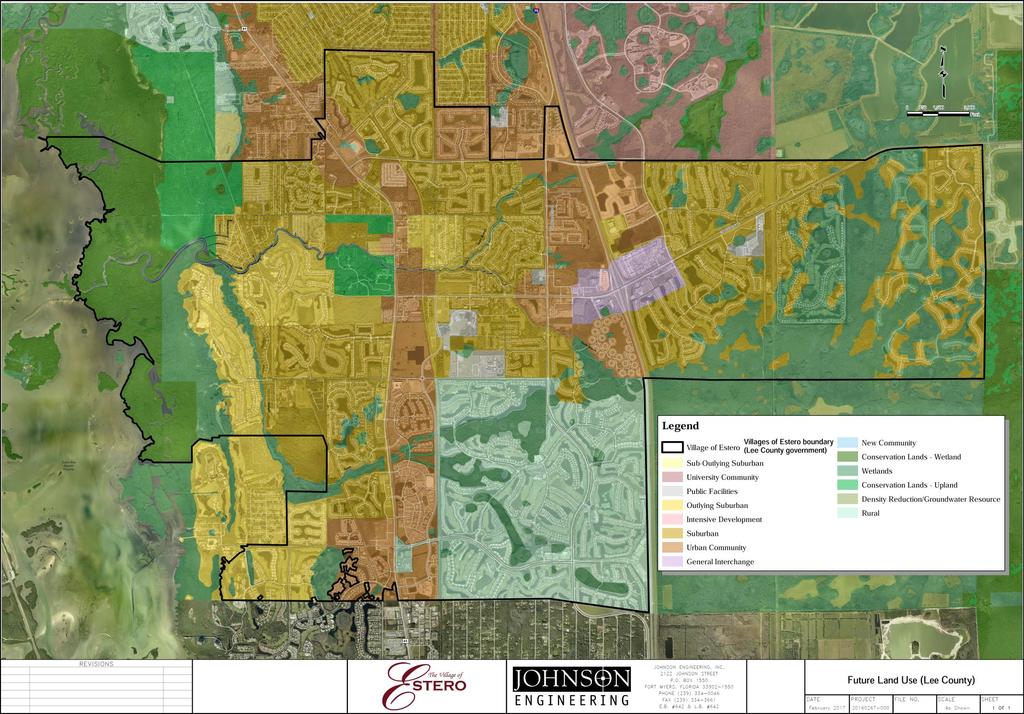
8 Lee County and Village Existing Future Land Use Categories CATEGORY USES RESIDENTIAL DENSITY County Policy Intensive Development County Policy Urban Community Mixed-use centers of high density residential, commercial, limited light industrial, office Intense commercial and residential, urban services, public and quasi-public, limited light industry, mixed-use Standard 7-14 du/ac Maximum 22 du/ac Standard 1-6 du/ac Maximum 10 du/ac County Policy Suburban County Policy Outlying Suburban County Policy Public Facilities County Policy General Interchange County Policy Rural County Policy Conservation Lands County Policy Wetlands Village Objective 19.8 Village Center Residential neighborhoods Rural or low density residential Public schools, parks, airports, public transportation, governmental facilities Tourist commercial, general commercial, light industrial/commercial, service stations, hotel, motel, restaurants, gift shops Low density residential, agricultural uses, minimal non-residential land uses, natural resource extraction wildlife preserves; wetland and upland mitigation areas and banks; natural resource based parks; environmental research/education, historic/cultural preservation; water conservation lands Very low density residential uses, recreational uses Higher densities and intensities of housing, employment, shopping, recreation, park, civic, walkable mixed use Standard 1-6 du/ac Standard 1-3 du/ac Maximum 1 du/ac Maximum 1 du/20 ac 4 Base Tiers 6-21 du/ac Maximum 27 du/ac
9 Lee County Future Land Use Policy The INTENSIVE DEVELOPMENT areas are located along major arterial roads in Fort Myers, North Fort Myers, East Fort Myers west of I-75, and South Fort Myers. By virtue of their location, the county's current development patterns, and the available and potential levels of public services, they are well suited to accommodate high densities and intensities. Planned mixed-use centers of highdensity residential, commercial, limited light industrial (see Policy 7.1.6), and office uses are encouraged to be developed as described in Policy , where appropriate. As Lee County develops as a metropolitan complex, these centrally located urban nodes can offer a diversity of lifestyles, cosmopolitan shopping opportunities, and specialized professional services that befit such a region. The standard density range is from seven dwelling units per acre (7 du/acre) to fourteen dwelling units per acre (14 du/acre). Maximum density is twenty-two dwelling units per acre (22 du/acre).
10 Lee County Future Land Use Policy The URBAN COMMUNITY areas are areas outside of Fort Myers and Cape Coral that are characterized by a mixture of relatively intense commercial and residential uses. Included among them, for example, are parts of Lehigh Acres, San Carlos Park, South Fort Myers, Iona/McGregor, Pine Island, and Gasparilla Island. Although the Urban Communities have a distinctly urban character, they should be developed at slightly lower densities. As the vacant portions of these communities are urbanized, they will need to maintain their existing bases of urban services and expand and strengthen them accordingly. As in the Central Urban area, predominant land uses in the Urban Communities will be residential, commercial, public and quasi-public, and limited light industry (see Policy 7.1.6) with future development in this category encouraged to be developed as a mixed-use, as described in Policy , where appropriate. Standard density ranges from one dwelling unit per acre (1 du/acre) to six dwelling units per acre (6 du/acre), with a maximum of ten dwelling units per acre (10 du/acre). Any bonus densities approved on the properties added to the Urban Community future land use category in conjunction with CPA must be achieved through use of the transfer of development rights program.
11 Lee County Future Land Use Policy The SUBURBAN areas are or will be predominantly residential areas that are either on the fringe of the Central Urban or Urban Community areas or in areas where it is appropriate to protect existing or emerging residential neighborhoods. These areas provide housing near the more urban areas but do not provide the full mix of land uses typical of urban areas. The standard residential densities are the same as the Urban Community category. Higher densities, commercial development greater than neighborhood centers, and industrial land uses are not permitted. Bonus densities are not allowed
12 Lee County Future Land Use Policy The OUTLYING SUBURBAN areas are characterized by their peripheral location in relation to established urban areas. In general, these areas are rural in nature or contain existing low-density development. Some, but not all, of the requisite infrastructure needed for higher density development is generally planned or in place. It is intended that these areas will develop at lower residential densities than other Future Urban Areas. As in the Suburban areas, higher densities, commercial development greater than neighborhood centers, and industrial land uses are not permitted. The standard density range is from one dwelling unit per acre (1 du/acre) to three dwelling units per acre (3 du/acre). Bonus densities are not allowed.
13 Lee County Future Land Use Policy The PUBLIC FACILITIES areas include the publicly owned lands within the county such as public schools, parks, airports, public transportation, and other governmental facilities. The allowable uses within these areas are determined by the entity owning each such parcel and the local government having zoning and permitting jurisdiction.
14 Lee County Future Land Use Policy The GENERAL INTERCHANGE areas are intended primarily for land uses that serve the traveling public: service stations, hotel, motel, restaurants, and gift shops. But because of their location, market attractions, and desire for flexibility, these interchange uses permit a broad range of land uses that include tourist commercial, general commercial and light industrial/commercial.
15 Lee County Future Land Use Policy The RURAL areas are to remain predominantly rural--that is, low density residential, agricultural uses, and minimal non-residential land uses that are needed to serve the rural community. Natural resource extraction may be permitted in accordance with Policy These areas are not to be programmed to receive urban-type capital improvements, and they can anticipate a continued level of public services below that of the urban areas. Maximum density in the Rural area is one dwelling unit per acre (1 du/acre).
16 Lee County Future Land Use Policy The CONSERVATION LANDS include uplands and wetlands that are owned and used for long range conservation purposes. Upland and wetland conservation lands will be shown as separate categories on the FLUM. Upland conservation lands will be subject to the provisions of this policy. Wetland conservation lands will be subject to the provisions of both the Wetlands category described in Objective 1.5 and the Conservation Lands category described in this policy. The most stringent provisions of either category will apply to wetland conservation lands. Conservation lands will include all public lands required to be used for conservation purposes by some type of legal mechanism such as statutory requirements, funding and/or grant conditions, and mitigation preserve areas required for land development approvals. Conservation Lands may include such uses as wildlife preserves; wetland and upland mitigation areas and banks; natural resource based parks; ancillary uses for environmental research and education, historic and cultural preservation, and natural resource based parks (such as signage, parking facilities, caretaker quarters, interpretive kiosks, research centers, and quarters and other associated support services); and water conservation lands such as aquifer recharge areas, flowways, flood prone areas, and well fields lands designated as conservation are also subject to more stringent use provisions of the 2020 Program or the 2020 ordinances
17 Lee County Future Land Use Policy Permitted land uses in WETLANDS consist of very low density residential uses and recreational uses that will not adversely affect the ecological functions of wetlands. All development in Wetlands must be consistent with Goal 114 of this plan. The maximum density is one dwelling unit per twenty acres (1 du/20 acre) except as otherwise provided in Table 1(a) and Chapter XIII of this plan.
18 Village of Estero Future Land Use Policy This comprehensive plan includes a VILLAGE CENTER category on the future land use map (also referred to as the Village Center Area ) which encourages higher densities and intensities of housing, employment, shopping, recreation, park and civic uses in a series of interconnected neighborhoods and mixed use areas. Policy allows landowners in the Village Center Area to develop within the standard density range and other requirements of the Urban Community category; however the Village of Estero encourages land to be developed or redeveloped with a greater mix of uses and higher densities when placed in walkable mixed-use patterns. * * * * * * * *
19 Village of Estero Village Center Future Land Use Policy Base and maximum residential densities will be set by the Village Council during the planned development rezoning process based on its determination of an application s compliance with this comprehensive plan and the specific standards and requirements for each tier. Increases in base residential densities may be allowed after consideration of incentive offers as provided in the Land Development Code. Densities cannot exceed the top of the following ranges: a) Tier 1: Base level is up to 6 dwelling units per acre of Tier 1-only land plus up to 3 additional dwelling units per acre of Tier 1-only land after consideration of accepted incentive offers, for a maximum of 9 dwelling units per acre of Tier 1-only land. b) Tier 2: Base level is up to 10 dwelling units per acre of Tier 2 land plus up to 4 dwelling units per acre of Tier 2 land after consideration of accepted incentive offers, for a maximum of 14. dwelling units per acre of Tier 2 land. c) Tier 3: Base level is up to 15 dwelling units per acre of Tier 3 land plus up to 5 dwelling units per acre of Tier 3 land after consideration of accepted incentive offers, for a maximum of 20. dwelling units per acre of Tier 3 land. d) Tier 4: Base level is up to 21 dwelling units per acre of Tier 4 land plus up to 6 dwelling units per acre of Tier 4 land after consideration of accepted incentive offers, for a maximum of 27. dwelling units per acre of Tier 4 land.
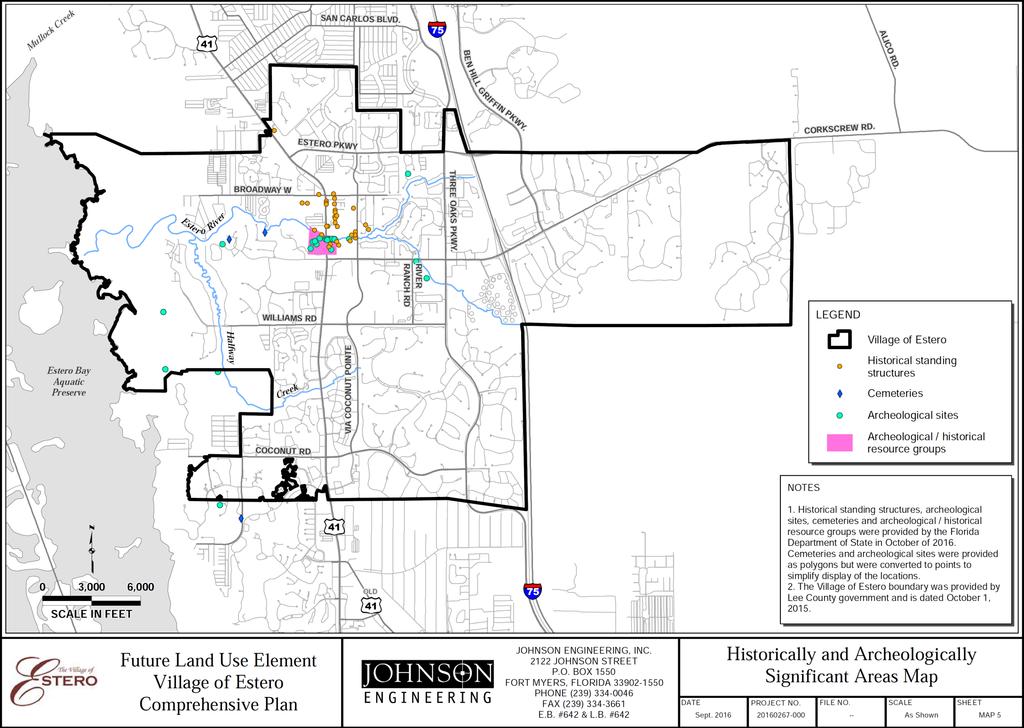
20 Historic & Archeological Resources Identify historical and archeological resources in Comprehensive Plan? Reliance on Lee County program? Evaluate ways to incentivize protection of resources
21 Overlays Identification of distinct neighborhoods Old Estero Corkscrew Road & US 41 Water dependent Maintain Lee County mixed use overlays or develop mixed use Future Land Use Category
22 Design Principles Architectural Styles Mixed use design standards Hardscape standards Sustainable Design Encourage active design principles Promotion of mixed use to reduce vehicle trips LEED certified development standards for government and commercial uses
23 Redevelopment & Infill Overlays vs Future Land Use Categories Context sensitive redevelopment of Historic and Conservation sites Policy which provides for Land Development Codes to adjust for redevelopment and infill development.
24 Density Bonuses and/or Transfer of Development Rights Land acquisition Public benefits Contribution to a community fund Diversity of housing types including workforce housing Environmental buffer sending sites
25 Annexation Policies Annexation is required to be addressed in the Comprehensive Plan No specific areas contemplated at this time Criteria and standards to determine areas that would offer benefits consistent with Village Vision Greenways Open space
26 Site Location Standards for Commercial Uses Determines maximum gross floor area Apply to uses which generate large volumes of traffic Exceptions allowed for certain uses and mixes of uses Current Policy could be kept, modified or removed
27 Nonconformity Provisions Adoption of new Plan could create some nonconforming situations Allowance for continuance of some nonconformities Procedures for conformance will be identified in the Plan Natural disaster build-back
28 Lee County 2030 Allocations Table Developed for Lee County Plan Required by Department of Community Affairs at the time No longer needed

29
30
31
32 Transportation Policy Issues Concurrency vs Mobility Multimodal / Complete Streets Bus stop design Bus pull-outs Bikeway / pedestrian facilities plan Traffic calming / road dieting External traffic issues Mine related traffic Interconnectivity Evacuation Routes Promotion of non-motorized greenway transportation projects where feasible Suntrail CSX/Seminole Gulf Rail Corridor right-of-way utilization (consider this corridor as it s own Future Land Use Category Road landscaping Estero-scape program Three Oaks standard Scenic corridors Road extensions Functional classification specific standards
33
34
35 A Vision for 2030 To establish a community that embraces its historic heritage and protects the environment, while carefully planning for future development resulting from a desirable high quality of life, expanding economic opportunities, and proximity to Florida Gulf Coast University and the Southwest Florida International Airport. Estero's growth will be planned with strong neighborhoods, diverse economic generators, interconnected mixed-use centers, varied parks, public spaces, recreational facilities, and unique natural environments that fosters a sense of belonging and creates a sense of place. Estero will be a highly valued place to live, work, and visit because of development standards and design guidelines that promote: 1) desirable neighborhoods and public amenities; 2) vibrant economic centers; 3) attractive landscaping, streetscaping, lighting, signage, and architectural features; and 4) an interconnected transportation network. The implementation of this vision will successfully link residential and commercial areas and uphold Estero as a vibrant Lee County community.
36 Questions and Comments
DIVISION OF PLANNING MEMORANDUM
 to: DIVISION OF PLANNING MEMORANDUM from: subject: Estero Community Planning Panel Kathie Ebaugh, AICP, Principal Planner Estero Goal, Objectives, and Policies date: March 18, 2014 Attached is the final
[THIS PAGE INTENTIONALLY LEFT BLANK]
![[THIS PAGE INTENTIONALLY LEFT BLANK]](/thumbs/77/76526040.jpg "[THIS PAGE INTENTIONALLY LEFT BLANK]") 1-1 LAND USE [THIS PAGE INTENTIONALLY LEFT BLANK] TABLE OF CONTENTS INTRODUCTION... 7 1-1. GOAL: TO DEVELOP AND MAINTAIN A WELL-BALANCED COMMUNITY WITH A VARIETY OF LAND USES THAT ARE COMPATIBLE WITH EACH
1-1 LAND USE [THIS PAGE INTENTIONALLY LEFT BLANK] TABLE OF CONTENTS INTRODUCTION... 7 1-1. GOAL: TO DEVELOP AND MAINTAIN A WELL-BALANCED COMMUNITY WITH A VARIETY OF LAND USES THAT ARE COMPATIBLE WITH EACH
CITY OF TARPON SPRINGS DCA#11-1AR
 Agenda Item #3.H.2 05/09/11 TAMPA BAY REGIONAL PLANNING COUNCIL LOCAL GOVERNMENT COMPREHENSIVE PLAN ADOPTED AMENDMENT REPORT CITY OF TARPON SPRINGS DCA#11-1AR 1 ADOPTED WITH THE FOLLOWING CHANGES: Ordinance
FUTURE LAND USE ELEMENT
 FUTURE LAND USE ELEMENT GOAL I: To create and sustain a great place to live, play, and prosper Objective 1: The City of Ocala shall incorporate the principles and strategies of the Ocala 2035 Vision into
NEW CASTLE COUNTY S ZONING DISTRICTS
 NEW CASTLE COUNTY S ZONING DISTRICTS This is general information about New Castle County s zoning districts. The information included is by no means exhaustive or complete. Before designing plans to develop
TREASURE COAST REGIONAL PLANNING COUNCIL M E M O R A N D U M. To: Council Members AGENDA ITEM 5H
 TREASURE COAST REGIONAL PLANNING COUNCIL M E M O R A N D U M To: Council Members AGENDA ITEM 5H From: Date: Subject: Staff October 17, 2008 Council Meeting Local Government Comprehensive Plan Review Draft
LAND USE ELEMENT. Purpose. General Goals & Policies
 LAND USE ELEMENT Purpose This Land Use Element contains the goals and policies necessary to support the City s responsibility for managing land resources and guiding development through implementing regulations,
TREASURE COAST REGIONAL PLANNING COUNCIL M E M O R A N D U M. To: Council Members AGENDA ITEM 5I
 TREASURE COAST REGIONAL PLANNING COUNCIL M E M O R A N D U M To: Council Members AGENDA ITEM 5I From: Date: Subject: Staff December 12, 2008 Council Meeting Local Government Comprehensive Plan Review Town
1. FUTURE LAND USE ELEMENT Goals, Objectives, and Policies
 1. Goals, Objectives, and Policies The has limited vacant land remaining for new development. Redevelopment is anticipated to represent nearly all development activity within the City. More City residents
AWH REPORT OF THE PLANNING AND DEVELOPMENT DEPARTMENT FOR APPLICATION FOR REZONING ORDINANCE TO PLANNED UNIT DEVELOPMENT
 AWH REPORT OF THE PLANNING AND DEVELOPMENT DEPARTMENT FOR APPLICATION FOR REZONING ORDINANCE TO PLANNED UNIT DEVELOPMENT MAY 8, 2014 The Planning and Development Department hereby forwards to the Planning
CHARLES PUTMAN CHARLES PUTMAN AND ASSOCIATES, INC
 MEMORANDUM CHARLES PUTMAN & ASSOCIATES, INC. LAND DEVELOPMENT CONSULTANTS PLANNING ZONING PERMITTING 4722 NW Boca Raton Boulevard, Suite C-106 Boca Raton, Florida 33431 Phone: 561/994-6411 FAX: 561/994-0447
Dwelling Units Max 12 dwelling units per acre/min 8 dwelling units per acre. Development Mix 80% non residential/20% residential
 13. OSTEEN LOCAL PLAN Background: The Osteen Local Plan area is located in southwest Volusia County along the SR 415 corridor between Lemon Bluff Road and Acorn Lake Road and includes 3,990 acres. The
The transportation system in a community is an
 7 TRANSPORTATION The transportation system in a community is an important factor contributing to the quality of life of the residents. Without a sound transportation system to bring both goods and patrons
Tāhuhu whakaruruhau ā-taone The sheltering ridge pole
 B2. Tāhuhu whakaruruhau ā-taone - Urban growth and form B2.1. Issues Tāhuhu whakaruruhau ā-taone The sheltering ridge pole Auckland s growing population increases demand for housing, employment, business,
City of Palm Coast 2035 Comprehensive Plan - Goals, Objectives, and Policies EXECUTIVE SUMMARY
 EXECUTIVE SUMMARY INTRODUCTION The original Comprehensive Plan, with two adopted planning timeframes, was adopted in 2004, following the City s incorporation in 1999. The first timeframe is five (5) years
3. VISION AND GOALS. Vision Statement. Goals, Objectives and Policies
 Vision Statement Queen Creek s interconnected network of parks, trails, open spaces and recreation opportunities provide safe and diverse activities and programs that sustain its unique, small town, equestrian
Plano Tomorrow Vision and Policies
 Plano Tomorrow Vision and Policies PLANO TOMORROW PILLARS The Built Environment The Social Environment The Natural Environment The Economic Environment Land Use and Urban Design Transportation Housing
This page intentionally blank.
 This page intentionally blank. Parks, Recreation, and Open Space Chapter Relationship to Vision Vision Parks, Recreation and Open Space Chapter Concepts County Government. County government that is accountable
Plan Modification to Chapter B2 of the Auckland Unitary Plan(AUP) Operative in part (15 November 2016)
 Operative in part (15 November 2016)") UNITARY PLAN UPDATE REQUEST MEMORANDUM TO FROM Phill Reid Linley Wilkinson DATE 25 September 2018 SUBJECT Plan Modification to Chapter B2 of the Auckland Unitary Plan(AUP) Operative in part (15 November
UNITARY PLAN UPDATE REQUEST MEMORANDUM TO FROM Phill Reid Linley Wilkinson DATE 25 September 2018 SUBJECT Plan Modification to Chapter B2 of the Auckland Unitary Plan(AUP) Operative in part (15 November
Chapter 10 IMPLEMENTATION RECOMMENDATIONS
 Chapter 10 IMPLEMENTATION RECOMMENDATIONS The recommended land use plan presented in the previous chapter provides a design for the attainment of the urban and rural development and open space preservation
Gloucester County s Comprehensive Plan. The Community Connection
 Gloucester County s Comprehensive Plan The Community Connection Current Comp Plan Adopted in 1991 with a 20 year planning horizon Updated in 1995 with Part V- Implementation Recommendations and Appendix
2040 LUP is a part of the Comprehensive Plan and carries the same legal authority. Economic Challenges
 1.1. Guiding Anchorage s Growth Where will new residents settle over the next two decades? Where will people work, shop, and play? Will there be enough room to grow? How will Anchorage look? Will growth
Warren County/Bowling Green Focus 2030 Comprehensive Plan VOLUME 1 INDEX
 Appendix 5: Index VOLUME 1 INDEX A Aesthetics ES-6, FLU-15, FLU-17, FLU-24, NCR-7 Agricultural Base FLU-18, FLU-20 Agricultural Centers, Rural FLU-11 Agricultural District NCR-17-NCR-18 Agricultural Economy
SAN RAFAEL GENERAL PLAN 2040 INTRODUCTION AND OVERVIEW
 SAN RAFAEL GENERAL PLAN 2040 INTRODUCTION AND OVERVIEW Steering Committee Presentation February 14, 2018 Purpose of General Plan Guide land use and development decisions Coordinate transportation, infrastructure,
17.11 Establishment of Land Use Districts
 17.11 Establishment of Land Use Districts 17.11.010 Purpose. To promote the health, safety, and general welfare of City residents and those who come to South Salt Lake to work, exchange commerce and recreate.
D-O LRT Zoning Discussion. Chapel Hill Boards & Commissions October 16, 2017
 D-O LRT Zoning Discussion Chapel Hill Boards & Commissions October 16, 2017 Update on Overall D-O LRT Station Area Initiative Objectives Design and educate on principles of Good Transit-Oriented Development
HOUSING ELEMENT GOALS, OBJECTIVES, AND POLICIES
 HOUSING ELEMENT GOALS, OBJECTIVES, AND POLICIES Goal 6 Maintain and enhance the supply of decent, safe, energy efficient and affordable housing and maximize viable options and opportunities for present
Support the implementation of Cape Coral's Comprehensive Plan. Protect and utilize the unique natural resources in the City.
 7.0 OVERVIEW - RECOMMENDATIONS Chapter 7 The preparation of the Cape Coral Parks and Recreation Master Plan spanned a period of approximately 12 months. Plan preparation included the input of a wide range
Chapter 2: Vision, Goals and Strategies
 Chapter 2: Vision, Goals and Lake Elmo Today & Tomorrow Comprehensive Plan 2040 2 VISION, GOALS & STRATEGIES - DRAFT 4-6-2018 INTRODUCTION Comprehensive Plan Purpose Perhapse the most important objective
A. WHAT IS A GENERAL PLAN?
 I. Introduction A. WHAT IS A GENERAL PLAN? A general plan is the planning guideline for the future of a city. It contains goals and policies which regulate urban development, the protection of the natural
SECTION UNIFIED DEVELOPMENT ORDINANCE SECTION Part 1 Ordinance. ARTICLE 1 Zoning Districts
 SECTION 1-100 UNIFIED DEVELOPMENT ORDINANCE SECTION 1-300 Part 1 Ordinance SECTION 1-100. Introduction. ARTICLE 1 Zoning Districts Crystal Lake strives to maintain a balance of various land uses for a
REPORT OF THE PLANNING AND DEVELOPMENT DEPARTMENT FOR APPLICATION FOR REZONING ORDINANCE TO PLANNED UNIT DEVELOPMENT AUGUST 18, 2016
 REPORT OF THE PLANNING AND DEVELOPMENT DEPARTMENT FOR APPLICATION FOR REZONING ORDINANCE TO PLANNED UNIT DEVELOPMENT AUGUST 18, 2016 AWH The Planning and Development Department hereby forwards to the Planning
Future Land Use SAMPLE RECOMMENDATIONS
 SAMPLE RECOMMENDATIONS Future Land Use The Future Land Use Chapter of the Master Plan builds upon prior chapters examining the existing conditions in their respective topic areas to present a comprehensive
CITY OF PUYALLUP. Background. Development Services
 CITY OF PUYALLUP Development Services 333 South Meridian Puyallup WA 98371 To: City Council From: Katie Baker, AICP, Planning Division Re: South Hill Neighborhood Plan Adoption Date: (Meeting date: February
Gold Line Bus Rapid Transit Transit Oriented Development (BRTOD) Helmo Station Area Plan
 Helmo Station Area Plan") Appendix F Gold Line Bus Rapid Transit Transit Oriented Development (BRTOD) Helmo Station Area Plan Introduction and Purpose of the Plan The Gold Line Bus Rapid Transit facility is an eleven-mile dedicated
Appendix F Gold Line Bus Rapid Transit Transit Oriented Development (BRTOD) Helmo Station Area Plan Introduction and Purpose of the Plan The Gold Line Bus Rapid Transit facility is an eleven-mile dedicated
BROOKHILL NEIGHBORHOOD MODEL ZONING MAP AMENDMENT PREFACE TO APPLICATION
 BROOKHILL NEIGHBORHOOD MODEL ZONING MAP AMENDMENT PREFACE TO APPLICATION June 15, 2015 Revised: August 1, 2016 I. VISION Brookhill is a proposed community based upon the principles of Albemarle County
CHAPTER 3 VISION, GOALS, & PLANNING PRINCIPLES. City of Greensburg Comprehensive Plan. Introduction. Vision Statement. Growth Management Goals.
 CHAPTER 3 VISION, GOALS, & PLANNING PRINCIPLES Introduction The Greensburg Comprehensive Plan is intended as a working community document. A combination of long and short-term goals, this document is intended
A citizen s guide to the. Comprehensive Plan. City of Lakeville, Minnesota 1
 A citizen s guide to the Comprehensive Plan 2008 City of Lakeville, Minnesota 1 Introduction The City of Lakeville completed an update of its Comprehensive Plan in 2008. A comprehensive plan is a tool
Planning & Zoning Commission Staff Report
 Planning & Zoning Commission Staff Report Meeting Date: May 26, 2015 Drafted by: Katherine Harrison-Rogers CASE # Z2886 PROJECT NAME: APPLICANT/ REPRESENTATIVE: Shawna Runyan PROPERTY OWNER: 1840 (previously
The Five Components of the McLoughlin Area Plan
 The Five Components of the McLoughlin Area Plan This documents contains the complete language of the five components of the McLoughlin Area Plan: The Vision Statement The Values The Guiding Principles
A Growing Community Rural Settlement Areas
 Town of Huntsville Official Plan Review - POLICY BACKGROUND PAPER A Growing Community Rural Settlement Areas BACKGROUND: In addition to the fully municipally-serviced Urban Settlement Area and the Hidden
2025 COMPREHENSIVE PLAN PASCO COUNTY, FLORIDA
 GOAL FLU 6: PASADENA HILLS FUTURE LAND USE: PASADENA HILLS AREA PLAN GOALS, OBJECTIVES, AND POLICIES PASADENA HILLS AREA PLAN: OVERVIEW The Pasadena Hills Area Plan Goals, Objectives, and Policies are
ALBEMARLE COUNTY CODE CHAPTER 18 ZONING SECTION 20A NEIGHBORHOOD MODEL - NMD
 CHAPTER 18 ZONING SECTION 20A NEIGHBORHOOD MODEL - NMD Sections: 20A.1 PURPOSE AND INTENT 20A.2 STATUS AS A PLANNED DEVELOPMENT DISTRICT 20A.5 CODES OF DEVELOPMENT 20A.6 PERMITTED USES 20A.7 RESIDENTIAL
Appendix C: Interim Mixed-Use Evaluation Criteria
 Appendix C: Interim Mixed-Use Evaluation Criteria C-1 Appendix C: Interim Mixed-Use Evaluation Criteria PURPOSE: The implementation of numerous policies contained within the Master Plan hinges on the creation
City of Woodinville Planning Commission Study Session. Development Regulations 101: An Overview of Specific Regulatory Items To Help You in 2012
 City of Woodinville Planning Commission Study Session Development Regulations 101: An Overview of Specific Regulatory Items To Help You in 2012 Development Regulations 101 Overview of the Different Zones
Rural Land Use Designations Kittitas County December 6, 2007 Draft
 KITTITAS COUNTY COMMUNITY DEVELOPMENT SERVICES 411 N. Ruby St., Suite 2, Ellensburg, WA 98926 CDS@CO.KITTITAS.WA.US Office (509) 962-7506 Fax (509) 962-7682 Rural Land Use Designations Kittitas County
Comprehensive Plan for Unincorporated Hillsborough County Florida
 Future of Hillsborough Comprehensive Plan for Unincorporated Hillsborough County Florida FUTURE LAND USE As Amended by the Hillsborough County Board of County Commissioners June 5, 2008 (Ordinance 08-13)
LAND USE OVERVIEW WHAT YOU WILL FIND IN THIS CHAPTER
 LAND USE WHAT YOU WILL FIND IN THIS CHAPTER Information about the City s expected population and employment growth. Description and capacity of existing and future land use designations. Policies that
2025 COMPREHENSIVE PLAN PASCO COUNTY, FLORIDA
 GOAL FLU 6: PASADENA HILLS FUTURE LAND USE: PASADENA HILLS AREA PLAN GOALS, OBJECTIVES, AND POLICIES PASADENA HILLS AREA PLAN: OVERVIEW The Pasadena Hills Area Plan Goals, Objectives, and Policies are
Windsor, Connecticut Plan of Conservation & Development DRAFT PLAN SUMMARY
 Windsor, Connecticut 2015 Plan of Conservation & Development DRAFT PLAN SUMMARY Plan Overview What is a Plan? Visionary Advisory Implementable Maintainable What it is not! Regulatory Binding Static Passive
Exhibit A-1: Future Land Use Element Goals, Objectives, and Policies
 Exhibit A-1: Future Land Use Element Goals, Objectives, and Policies GOAL 1 IMPROVE THE QUALITY OF LIFE AND ACHIEVE A SUPERIOR, SUSTAINABLE, DEVELOPMENT PATTERN IN THE CITY BY CREATING AND MAINTAINING
Silverdale Regional Center
 Silverdale Regional Center Vision for Silverdale Regional Center The Silverdale Regional Center Plan (Plan) will guide the evolution of the Silverdale Regional Center from a collection of strip malls and
VILLAGE OF CLEMMONS PLANNING BOARD DRAFT STAFF REPORT
 VILLAGE OF CLEMMONS PLANNING BOARD DRAFT STAFF REPORT PETITION INFORMATION Docket # C-226 Staff Megan Ledbetter Petitioner(s) JBJH Properties, LLC Owner(s) JBJH Properties, LLC Subject Property 5892-49-1766
4 LAND USE DESIGNATIONS
 4 LAND USE DESIGNATIONS Chapter 4 describes the land use designations and densities that will implement the development vision for North Burlingame outlined in Chapter 3. Land use densities are described
GENERAL PLAN AND ENVIRONMENTAL IMPACT REPORT
 City of Menifee HEARING DRAFT GENERAL PLAN AND ENVIRONMENTAL IMPACT REPORT City Council November 2013 PURPOSE OF MEETING Overview of GP Process Overview of required and optional GP elements Receive direction
CHAPTER 7: Transportation, Mobility and Circulation
 AGLE AREA COMMUNITY Plan CHAPTER 7 CHAPTER 7: Transportation, Mobility and Circulation Transportation, Mobility and Circulation The purpose of the Transportation, Mobility and Circulation Chapter is to
FUTURE LAND USE. FUTURE LAND USE: Amended June 15, 2017 Through Ordinance No PAGE 1-1
 1 FUTURE LAND USE Amended June 15, 2017 Through Ordinance No. 3800 PAGE 1-1 Summary- New and Current Future Land Uses Category New name and allowable uses 1. Residential Low Density: low-density single
Goals, Objectives and Policies
 Goals, Objectives and Policies GOAL ONE: THE PATTERN OF LAND USE IN PINELLAS COUNTY SHALL PROVIDE A VARIETY OF URBAN ENVIRONMENTS TO MEET THE NEEDS OF A DIVERSE POPULATION AND THE LOCAL ECONOMY, CONSERVE
CHAPTER 4 FUTURE LAND USE AND URBAN SERVICES DISTRICTS
 CHAPTER 4 FUTURE LAND USE AND URBAN SERVICES DISTRICTS Introduction This chapter discusses how Benzie County should grow and change in the future. A community can grow and change in many different ways.
RECREATION, OPEN SPACE AND GREENWAYS ELEMENT GOALS, OBJECTIVES, AND POLICIES
 RECREATION, OPEN SPACE AND GREENWAYS ELEMENT GOALS, OBJECTIVES, AND POLICIES GOAL R-1: DEVELOP A RECREATION, OPEN SPACE AND GREENWAYS SYSTEM AS AN INTEGRAL COMPONENT OF AN OVERALL, COUNTY-WIDE ECONOMIC
FUTURE DEVELOPMENT AREAS
 FUTURE DEVELOPMENT AREAS Refer to the Future Development Map on Page 2. Suburban Residential (Less than 3 units/acre) Suburban Residential neighborhoods form the backbone of Smyrna. While growth and redevelopment
1.0 Circulation Element
 5/9/18 1.0 Circulation Element 1.1 Introduction As growth and development occur in Apache County, enhancements to its circulation system will be necessary. With time, more roads will be paved and air and
SECTION II SECTION II STATEMENT OF GOALS, OBJECTIVES, PRINCIPLES, ASSUMPTIONS, POLICIES AND STANDARDS
 STATEMENT OF GOALS, OBJECTIVES, PRINCIPLES, ASSUMPTIONS, POLICIES AND STANDARDS 1 2 STATEMENT OF GOALS, OBJECTIVES, PRINCIPLES, ASSUMPTIONS, POLICIES AND STANDARDS INTRODUCTION The New Jersey Municipal
MEMORANDUM AGENDA ITEM #6c
 South Florida Regional Planning Council MEMORANDUM AGENDA ITEM #6c DATE: FEBRUARY 1, 2010 TO: FROM: SUBJECT: COUNCIL MEMBERS STAFF CITY OF PARKLAND PROPOSED COMPREHENSIVE PLAN AMENDMENT (ALTERNATIVE REVIEW)
Source: Albemarle County Community Development 2010
 Source: Albemarle County Community Development 2010 GROWTH MANAGEMENT GOAL: Albemarle County s Development Areas will be attractive, vibrant areas for residents and businesses, supported by services, facilities,
WATERFORD Plan of Preservation, Conservation and Development Supplement Part 1 - Policy Element
 WATERFORD 2012 Plan of Preservation, Conservation and Development 2015 Supplement Part 1 - Policy Element Effective June 11, 2015 2015 Plan Update GOAL To respond to the evolving land use needs and continually
Vision Statement for the Town of Flower Mound Master Plan The Town of Flower Mound Master Plan furthers the established community based vision to:
 Vision Statement for the The furthers the established community based vision to: Preserve the country atmosphere and natural environment that makes Flower Mound a unique and desirable community; Mitigate
Chapter 4. Linking Land Use with Transportation. Chapter 4
 Chapter 4 Linking Land Use with Transportation Chapter 4 59 Chapter 4 Linking Land Use with Transportation Community Design and Transportation Program Introduction Since the 1950s, the predominant development
KAMPLAN City of Kamloops. Section D. Land Use Policies D-1
 KAMPLAN City of Kamloops Section D Land Use Policies D-1 City of Kamloops KAMPLAN D 1 Land Management and Development This section links to the following Community Values: D-2 develop complete neighbourhoods
CHAPTER 12 IMPLEMENTATION
 CHAPTER 12 IMPLEMENTATION The 2010 Town of Denton Comprehensive Plan is intended to capture a vision of the future of Denton. As such, it provides a basis for a wide variety of public and private actions
FUTURE LAND USE PLAN 7
 FUTURE LAND USE PLAN 7 The recommendations of each of the preceding chapters can be combined to present an overall Future Land Use Plan for Wilton. The Future Land Use Plan, presented on the following
S A C R A M E N T O C O U N T Y JACKSON HIGHWAY & GRANT LINE EAST VISIONING STUDY
 JACKSON HIGHWAY & GRANT LINE EAST S A C R A M E N T O C O U N T Y P L A N N I N G D E P A R T M E N T SUMMARY AND WORKBOOK November 19, 2008 History of the Visioning Study Sacramento County has two growth
LAND USE GOALS, OBJECTIVES AND POLICIES. Goal 1: [L] (EFF. 7/16/90)
![LAND USE GOALS, OBJECTIVES AND POLICIES. Goal 1: [L] (EFF. 7/16/90)](/thumbs/88/115018937.jpg "LAND USE GOALS, OBJECTIVES AND POLICIES. Goal 1: [L] (EFF. 7/16/90)") LAND USE GOALS, OBJECTIVES AND POLICIES Goal 1: [L] (EFF. 7/16/90) The Comprehensive Plan shall protect and enhance the quality of life in this community by providing economically sound educational, employment,
LAND USE GOALS, OBJECTIVES AND POLICIES Goal 1: [L] (EFF. 7/16/90) The Comprehensive Plan shall protect and enhance the quality of life in this community by providing economically sound educational, employment,
The City shall enhance and improve the accessibility of parks and recreational facilities while protecting their quality. by:
 GOALS, OBJECTIVES AND POLICIES GOAL 1: To provide open space and recreation as an essential element needed for the betterment of the City s character and quality of urban life. The City shall plan for
Joint Meeting City Council and the Plan Commission. September 1st, 2015
 Joint Meeting City Council and the Plan Commission September 1st, 2015 1 The City Plan Commission shall recommend a City Plan for the physical development of the City Article IX Section 2 of the City of
Intergovermental Coordination
 Intergovermental Coordination CITY OF WINTER PARK CHAPTER 8: INTERGOVERNMENTAL COORDINATION ELEMENT INTERGOVERNMENTAL COORDINATION ELEMENT GOAL 8-1: PROVIDE FOR IMPROVED INTERGOVERNMENTAL COORDINATION
PORT WHITBY COMMUNITY
 PORT WHITBY COMMUNITY SECONDARY PLAN UPDATE COMMUNITY IMPROVEMENT PLAN URBAN DESIGN GUIDELINES September 2015 DRAFT PROPOSED AMENDMENT NUMBER # to the Whitby Official Plan PURPOSE: The intent of this Amendment
Subject: Hendry County Evaluation and Appraisal Report Letter of Understanding - Identification of Major Issues
 HENDRY COUNTY PLANNING & ZONING DEPARTMENT POST OFFICE BOX 2340 165 S. LEE STREET LABELLE, FLORIDA 33975 (863) 675-5240 FAX: (863) 675-5317 SUNCOM 744-4750 November 16, 2007 Mr. Mike McDaniel, Chief Office
G. RECREATION AND OPEN SPACE ELEMENT. The following summarizes the Recreation and Open Space Element:
 G. RECREATION AND OPEN SPACE ELEMENT The purpose of the Element is to provide the framework and direction for a comprehensive system of public and private sites for recreation, including, but not limited
West Ocala Vision & Community Plan City Council Work Session. Presented by West Ocala Community Plan Steering Committee
 West Ocala Vision & Community Plan City Council Work Session Presented by West Ocala Community Plan Steering Committee November 29,2011 Ocala 2035 Vision West Ocala Community Vision & Master Plan West
4.1.3 LAND USE CATEGORIES
 4.1.3 LAND USE CATEGORIES a. City Center District The City Center District incorporates the existing character and mix of uses in downtown Belmont to encourage redevelopment and new development in keeping
THE 355/270 CORRIDOR:
 THE 355/270 CORRIDOR: Strategic Ideas for Sustaining a Livable Work Place Project Summary ACCESS LIFE DESIGN HEALTH WORK Montgomery County Planning Department The Maryland-National Capital Park and Planning
DRAFT City of Titusville 2040 Comprehensive Plan Future Land Use, Housing, and Transportation Elements April 16, 2018
 DRAFT City of Titusville 2040 Comprehensive Plan Future Land Use, Housing, and Transportation Elements April 16, 2018 Prepared by Canin Associates for the City of Titusville About the Comprehensive Plan:
Ridgefield and the Growth Management Act
 1 2 Ridgefield and the Growth Management Act 3 Why Do We Plan History of Planning in Ridgefield Washington experiences rapid growth in the late 1980 s that began to change the perceived quality of life.
1. Parks & Recreation Neighborhood Parks Community Parks Special Use Sites 2. Open Space 3. Trails
 Appendix A: Park Classifications The intent of parks and recreation classifications is to aid in making acquisition and design decisions for park sites, facilities and the organization of recreation space
RECREATION AND OPEN SPACE ELEMENT GOALS, OBJECTIVES, AND POLICIES
 RECREATION AND OPEN SPACE ELEMENT GOALS, OBJECTIVES, AND POLICIES Goal 7 To provide park facilities, recreation programs, and open space resources that are safe, adequate, and accessible to all City residents,
Sorted citizen input comments in review of Blount County plans July, August, and September 2007
 Sorted citizen input comments in review of Blount County plans July, August, and September 2007 The following presents sorted citizen input comments from three sessions held in July, August and September
Staff Report and Recommendation
 Community Planning and Development Planning Services 201 W. Colfax Ave., Dept. 205 Denver, CO 80202 p: 720.865.2915 f: 720.865.3052 www.denvergov.org/cpd TO: City Council Neighborhoods and Planning Committee
Proposed Comprehensive Plan Strategies DRAFT for discussion June 28, 2017
 Proposed Comprehensive Plan Strategies DRAFT for discussion June 28, 2017 Land Use Rural Areas Refine the Farm and Forest area (FF) Update FF boundaries to account for existing lots less than five acres
CHAPTER 7: VISION AND ACTION STATEMENTS. Noble 2025 Vision Statement
 CHAPTER 7: VISION AND ACTION STATEMENTS This chapter presents the vision, policy and action statements that transform the comprehensive planning study, an analysis of Noble s past, future trends and community
6 PORT SYDNEY SETTLEMENT AREA
 Section 6 Port Sydney Page 61 6 PORT SYDNEY SETTLEMENT AREA 6.1 Basis and Principles Village of Port Sydney Waterfront Community Existing Services 6.1.1 Port Sydney is an historic settlement that has developed
Town Center (part of the Comprehensive Plan)
") Town Center (part of the Comprehensive Plan) Mercer Island Town Center Looking North (2014) In 1994, a year-long process culminated in a set of design guidelines and code requirements for the Town Center
Town Center (part of the Comprehensive Plan) Mercer Island Town Center Looking North (2014) In 1994, a year-long process culminated in a set of design guidelines and code requirements for the Town Center
Guiding Principles, Objectives, Strategies and Policies
 Guiding Principles, Objectives, Strategies and Policies Section 1 Introduction These Guiding Principles were adopted as part of the 1999 Athens-Clarke County Comprehensive Plan and are carried over, in
BRANAN FIELD MASTER PLAN
 EXHIBIT L BRANAN FIELD MASTER PLAN GOALS, OBJECTIVES AND POLICIES Table of Contents Section Page 1. Future Land Use Element...1 2. Transportation Element...17 3. Recreation and Open Space Element...21
PLANNING COMMISSION. Agenda Item # 3.
 PLANNING COMMISSION Agenda Item # 3. CASE SUMMARY Conditional District Rezoning Planning Commission February 4, 2015 CD-9-215 Jeff Walton, 341-3260, jeff.walton@wilmingtonnc.gov Staff recommendation CONDITIONAL
EXECUTIVE SUMMARY DRAFT CHAPTER 1 INTRODUCTION EXECUTIVE SUMMARY
 CHAPTER 1 EXECUTIVE SUMMARY INTRODUCTION Through the joint efforts of the City of Tulsa planning staff and the Land Services division of Indian Nations Council of Governments (INCOG), the Berryhill Land
Planning Proposal Charlestown Swim and Leisure Centre LEP Amendment
 Planning Proposal Charlestown Swim and Leisure Centre LEP Amendment Amendment No. 4 to Lake Macquarie Local Environmental Plan 2014 (PP_2014_LAKEM_005_00) Local Government Area: Name of Draft LEP: Lake
Future Land Use Element Goals, Objectives & Policies
 Future Land Use Element Goals, Objectives & Policies Future Land Use Element Goals, Objectives, and Policies 163.3177(6)(a) 9J-5.006(3) Overall Goal City of Bunnell Future Land Use Element Ensure that
SUBJECT: LOCAL GOVERNMENT COMPREHENSIVE PLAN PROPOSED AND ADOPTED AMENDMENT CONSENT AGENDA
 MEMORANDUM AGENDA ITEM #IV.C DATE: APRIL 15, 2019 TO: FROM: COUNCIL MEMBERS STAFF SUBJECT: LOCAL GOVERNMENT COMPREHENSIVE PLAN PROPOSED AND ADOPTED AMENDMENT CONSENT AGENDA Pursuant to the 1974 Interlocal
2018 Northampton Township Comprehensive Plan
 2018 BUCKS COUNTY, PENNSYLVANIA What is a? A comprehensive plan is a municipality s main policy document that details the collective vision for the future, the historic, environmental, and cultural facilities