BEMIDJI CITY COUNCIL Work Session Agenda Monday July 9, 2012
|
|
|
- Andra Walton
- 5 years ago
- Views:
Transcription

1 BEMIDJI CITY COUNCIL Work Session Agenda Monday July 9, 2012 City Hall Conference Room 5:30 p.m. 1. CALL TO ORDER / ROLL CALL 2. REVIEW PARK PLANS FOR PAUL BUNYAN PARK, LIBRARY PARK AND SOUTH SHORE BAUER & ASSOCIATES 3. STORM CLEANUP DISCUSSION / UPDATE 4. ADJOURNMENT


 Bemidji State")


2 Paul Bunyan. Library & South Shore Park Master Plans Legend: C i t y o f B e m i d j i, M i n n e s o t a Paul Bunyan State Trail Paved City Trail (Lakeshore Trail) Paved City Trail (East - West Trail) Bemidji State University & Diamond Point Park To Lake Bemidji State Park Downtown Bemidji & Paul Bunyan / Library Park Sanford Center Development & South Shore Park To Walker, MN R e g i o n a l A t t r a c t i o n s a n d C o n n e c t i o n s Board 1 Project # Date: Excelsior Boulevard, Suite One Hopkins, MN Tel: Fax: N Graphic Scale


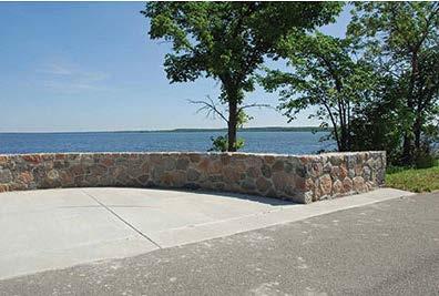
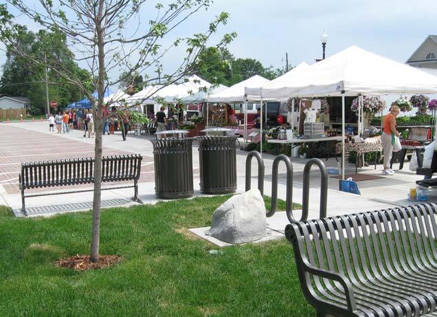
3 Paul Bunyan. Library Park Master Plan C i t y o f B e m i d j i, M i n n e s o t a Master Plan Highlights Remove 3rd Street exit and improve pedestrian flow to downtown and via the Lake Shore Trail Energy is focused on the 3rd Street spine, which includes multiple nodes for water features, sculptures, seating spaces and vendor spaces Plaza areas for events, markets, rental facilities, etc. Utilize wi-fi and barcode technology to increase daily use and provide up-to-date visitor information Family orientated space including a picnic shelter and play area in central area of the park Library Park is a designated passive space Vehicular & Canoe/Kayak Lake Access Plaza Rentable canoe / kayak racks Direct access to lake Bike rack & trash receptacle Lake access to be maintained during the winter season Overlook Seating Plaza - typ. Adirondack style chairs with adjacent tables Seat walls define space Existing Paved Trail Connection to South Shore / Sanford Center & Paul Bunyan State Trail 10 wide Accessible Trail Connection to/from East-West Trail Via Hwy 197 underpass Clean up vegetation along shoreline for increased visibility within this corridor Improve lighting along trail and under bridge Vehicle access for pier maintenance River Dock Concrete Access Platform Embedded sleeves for attaching dock to shore Accessible concrete access platform Trail Connection to Diamond Point Park and Bemidji State University Wayfinding / Park ID Signage Consistent style throughout park Sculpture Overlook Platform Sculpture to be determined Stormwater Pond Naturalize / clean up perimeter Decorative fountains Plaza for Misc. Events ~ 30 x 40 concrete surfacing To be used for awards ceremonies, movie night, etc. Swinging Benches Temporary Event Docks - typ. Provided and installed by others for specific events Accessible concrete access platform Picnic Area - typ. Accessible picnic tables and grills on a concrete pad Safety Fencing Along This Section of Trail Concrete maintenance strip Shoreline Stabilization & Restoration - typ. Rock armoring with native vegetation buffer Include measures to control geese Existing Historical Overlooks Wayfinding Signage Directional signs indicating key amenities and features within the park and the city Positioned at critical intersections Plaza Space for Events or Markets Easily accessible from parking lot and regional trail Park ID Monument Sign 6th St. Overlook Seating - typ. Carnegie Library Site Improvements Shown as being moved 10 to the east Enlarged concrete plaza space on street side of building Relocate or screen utilities on south side of building Improved lighting behind building 5th St. 4th St. Chief Bemidji Statue Adjacent bench seating Overlook Seating - typ. Street Banners - typ. Concrete Stair Connection to Lake Level 3rd St. 10 Wide Asphalt Trail Temporary Tent Space Re-Grade Lawn Area Adjust slope of lawn area to improve drainage and minimize mowing / maintenance time 2nd St. Asphalt Parking Lot Remove 3rd Street exit 2-way traffic 96 spaces + 4 H.C. Bus Loading / Unloading and Parking area on north end Pedestrian Connection Improvements at 2nd, 3rd, 5th and 6th Streets Remove 3rd Street exit from park Remove 4th & 6th Street crosswalk pavement from Hwy 197 Crosswalk enhancements Signage along road directing people to the park and downtown district Banners For 3rd Street Spine 10 Wide Concrete Accessible Trail Connection to Regional Trail Enlargement See Board 3 P r e l i m i n a r y M a s t e r P l a n Board 2 Project # Date: Excelsior Boulevard, Suite One Hopkins, MN Tel: Fax: Graphic Scale N

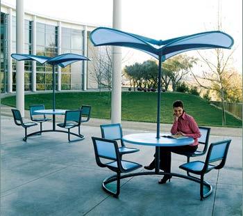
4 Paul Bunyan. Library Park Master Plan C i t y o f B e m i d j i, M i n n e s o t a Trailhead & Wayfinding Signage / Kiosk Consistent style throughout park Integrate into Visitor Center building Link to downtown - utilize smartphone technology and barcodes for up-to-date information Adjacent bike racks Bike Rental Area Similar to Nice Ride rentals Day-to Day Vendor Areas Cafe Style Seating with Umbrellas - typ. Designated Sculpture Space Limestone paver walkway Native vegetation surrounding 10 Asphalt Trail (LakeShore Trail) Realigned for better flow through the park Enhanced Existing Rip Rap Level lawn area to allow for event vendor space Water Plaza 18 high granite faced seat walls surround Glider benches inset into seat walls Center sculpture with feature boulders and water bubblers Decorative concrete Trash Receptacle 3rd Street Intersection Remove 3rd Street exit from park Crosswalk pavement design Signage along roadside directing people to the park and downtown district Future Downtown Gateway (By Bemidji s DDA) 3rd Street Pedestrian Gateway Nimi Sculpture Seat Walls - typ. 18 high granite walls to match historic overlooks landscape plantings within Centralized Donor Recognition Monument 3rd Street Dock Accessible concrete access platform Feature Boulders placed along edge of concrete Relocate Pillar sculptures to flank each side of platform Adjacent bench seating overlooking lake Trash Receptacle Landscape Area At-grade landscaping bed Native plantings Feature Boulders and timbers 8 long bench seating with center arms Trash Enclosure Space for (2) 2 CY dumpster and additional space for large event dumpsters Picnic Pavilion Relocate the existing Rotary Pavilion Built-in grills on lake side Update style to compliment park updates Trash receptacle and drinking fountain Street Banners - typ. Brick or concrete maintenance band between parking and trail Loading / Unloading / Drop-off Area & Bus / RV Parking Designated Sculpture Space Paul Bunyan & Babe Sculptures Maintain and improve the evergreen vegetation behind the sculptures Decorative Fencing 36 high ornamental fencing Style to complement highway 197 fencing Inset bench seating Trash Receptacle - typ. 10 Wide Asphalt Trail Children s Play Area 3,0000 SF play container Themed equipment Wood fiber & synthetic poured-in-place safety surfacing Adjacent bench seating Preliminary Master Plan Enlargement - 3rd Street Spine Board 3 Project # Date: Excelsior Boulevard, Suite One Hopkins, MN Tel: Fax: N Graphic Scale

 Day - to -Day Vendors Bike Rental (~15-20 bicycles) 6 curb cut 3rd Street Pedestrian Gateway 15 wide crosswalk entry point 6 curb cut")


5 Paul Bunyan. Library Park Master Plan C i t y o f B e m i d j i, M i n n e s o t a Existing Oak Tree Granite Face Pillar with Concrete Base and Top Cap Vendor Space Opportunities Potential Donor Recognition Steel Beam with Center Cornice 60 x 120 tent space Event Vendors Circular Artwork with Cutouts to View Through to the Lake (graphic to illustrate spirit of intent only) Day - to -Day Vendors Bike Rental (~15-20 bicycles) 6 curb cut 3rd Street Pedestrian Gateway 15 wide crosswalk entry point 6 curb cut Pedestrian Gateway 6 curb cut 15 wide crosswalk entry point 6 curb cut Through Route for Vehicles and Trailers Existing Hwy 197 Bridge 6 Sidewalk 3 High Concrete Retaining Wall To Downtown 8-10 Blvd South Bound Lanes North Bound Lanes 8-10 Blvd 10 Paved Trail To Paul Bunyan / Library Park 3 Clear Zone 3 Clear Zone Enhanced Landscaping - Both Sides of Street 12 Wide Asphalt Trail Minimum 10 Clearance Channel Between Lake Bemidji & Lake Irving Security Lighting Under Bridge 42 High Safety Fencing Native Vegetation and Shoreline Armoring Highway 197 Pedestrian Crossing Light poles with Downtown Bemidji Banners Wayfinding Signage Highway 197 Bridge Trail Connection M a s t e r P l a n D e t a i l s Board 4 Project # Date: Excelsior Boulevard, Suite One Hopkins, MN Tel: Fax:

 Granite Faced Wall (To match historical overlooks) Curb Cut for Vehicular and Accessible Pedestrian Access Concrete Plaza for Events / Markets 8 Wide Asphalt Trail")

 Native Vegetation (3-4 high max.")
6 Paul Bunyan. Library Park Master Plan C i t y o f B e m i d j i, M i n n e s o t a 10 Wide Asphalt Trail Concrete Access Platform Open Lawn Area Rip Rap Armoring with Native Vegetation Buffer Temporary Boat Docks for Events Feature Boulders Around Platform 6 Wide Accessible Aggregate Walkway Concrete Plaza Rip Rap Armoring with Native Vegetation Buffer Adirondack Chairs with Tables Cantilevered Canopy (Can be retracted during inclement weather) Granite Faced Wall (To match historical overlooks) Curb Cut for Vehicular and Accessible Pedestrian Access Concrete Plaza for Events / Markets 8 Wide Asphalt Trail Trash Receptacle Concrete Plaza Aggregate / Sand Launching Area Open Lawn Area 10 Wide Asphalt Trail Shoreline Buffer Lake Bemidji Bench Seating Rentable Canoe / Kayak Racks - typ. Bike Rack Feature Boulders Around Plaza Temporary Event Dock / Designated Lake Access Points Overlook Seating Plaza Vehicular & Canoe / Kayak Lace Access Plaza Highway 197 Existing Oak Trees & Lawn Space 5 Wide Bench Seating Area 10 Wide Asphalt Trail Overlook With Sculpture Open Lawn Area Donor recognition plaques (past and future contributions) Precast concrete cap Granite Faced Wall (to match historical overlooks) Native Vegetation (3-4 high max.) Feature Boulders within planting area Views to Lake Light poles with Downtown Bemidji or Park Banners Library Park Sculpture Overlook Platforms Granite Faced Wall (To match historical overlooks) Centralized Donor Recognition Monument M a s t e r P l a n D e t a i l s Board 5 Project # Date: Excelsior Boulevard, Suite One Hopkins, MN Tel: Fax:


7 Paul Bunyan. Library Park Master Plan Idea Board Board City 6 o f B e m i d j i, M i n n e s o t a Project # Date: Excelsior Boulevard, Suite One Hopkins, MN Tel: Fax:
8 Paul Bunyan / Library Park Master Planning Project City of Bemidji Parks and Recreation Presented By: 701 Xenia Avenue South, Suite 300 Minneapolis, MN June 9 th, 2012
9 Planning Process Kick-off meeting with city staff March 1 Stakeholder / user group interviews March Program meeting open house meeting April 13 Concept review open house meeting May 8 Master plan review open house meeting June 4 City Council master plan presentation Today 1
10 Planning for and Beyond Paul Bunyan / Library Park All public spaces along the west and south shore of the lake function together in an interdependent manner to achieve the broader vision of the system plan. (2011 system plan) 2


11 3 Paul Bunyan / Library Park Overall master plan

12 4 Paul Bunyan / Library Park 3 rd Street spine enlargement plan

13 5 Paul Bunyan / Library Park Centralized Donor Recognition Monument

14 Paul Bunyan / Library Park Alternate Shoreline Restoration / Stabilization Option 15 of parkland is lost, but the shoreline is still protected from erosion and it creates a barrier for geese the sand shoreline remains, thus allowing boats to beach designated breaks or access points in the rip rap allow for people to move between the sand beach and the park these access points will require annual maintenance due to ice heaves sand replacement might also be an issue if wheelchair access is needed within the sand it would be up to the organization holding the event to provide and install beach mats 14
15 Paul Bunyan / Library Park Cost Estimate Park Improvement Description Cost Range Estimate Low High 1 Removals, Earthwork and Surveying $137, $158, Utilities, Lighting and Irrigation Improvements $413, $ Main Visitor Center Improvements $464, $533, Water Plaza $180, $207, rd Street Dock Plaza $17, $20, Family / Group Gathering Area $255, $294, Canoe / Kayak Plaza $33, $38, Library Park Sculpture Overlooks $50, $58, Library Park Seating Overlooks $53, $61, Lakeshore Seating Overlooks $94, $108, Misc. Pavement and Surfacing $499, $574, Misc. Site Amenities $123, $141, Landscaping $368, $424, Highway 197 Pedestrian Improvements $286, $329, Total estimated construction cost: $2,979, $3,426, These estimated costs are also based on having the work completed by private contractors and specialists. It does not take into consideration work that could be performed by City staff, volunteer groups, or by other means. Costs include 10% contingency and 15% testing, construction documents and surveying fees. 6


16 South Shore Park Master Plan 7
17 South Shore Park Cost estimate Park Improvement Description Cost Range Estimate Low High (+15%) 1 Removals, Earthwork and Surveying $50, $58, Utilities, Lighting and Irrigation Improvements $118, $136, Play Area $674, $775, Misc. Pavement and Surfacing $129, $149, Misc. Site Amenities $206, $237, Landscaping $48, $55, Lakeshore Seating Overlooks $175, $201, Vehicular Drop-off / Pick-up Area $76, $88, Total estimated construction cost: $1,481, $1,703, # Additional Costs Low High 1 Building improvements (based on previous planning study) 265, , These estimated costs are also based on having the work completed by private contractors and specialists. It does not take into consideration work that could be performed by City staff, volunteer groups, or by other means. Costs include 10% contingency and 15% testing, construction documents and surveying fees. 2 Beach / Lake cleanup (based on previous planning study) 1,200, ,380,
18 The Next Steps Master planning for the proposed improvements was the first step in making the public s ideas become reality. This level of design sets the purpose, goals and general guidelines for the project. As funding becomes available to proceed with part or all of the improvements, design refinements will be required. In order of refinement, the following are the normal steps taken toward realizing the proposed improvements of any given project: Define Priorities for Potential Phasing Apply for Grants Further Refine Design Schematic Design Design Development Construction Documents and Agency Review and Approvals 9


19 11 Design Details Paul Bunyan / Library Park


20 12 Design Details Paul Bunyan / Library Park


21 13 Design Details Paul Bunyan / Library Park

 with native vegetation buffer Include measures to control geese Shade Umbrellas-")


22 South Shore Park Master Plan City Seasonal Docks - typ. Boulder Retaining Wall Day docks for park users or retail shoppers Permanent accessible concrete access platform Cafe Style Seating with Umbrellas - typ. Designated Sand Beach Area o f B e m i d j i, M i n n e s o t a Shoreline Stabilization & Restoration - typ. Defined by concrete border and walkway Small turf lawn space on both sides of beach Rock armoring (where necessary) with native vegetation buffer Include measures to control geese Shade Umbrellas- typ. Built-in Grill with Serving Counter Space Stormwater Pond - typ. Seasonal 10 Wide Asphalt Trail Naturalized perimeter Decorative fountain Lighted - style to match Sanford Center development Paul Bunyan State Trail Paved Trail Connection to Downtown and Paul Bunyan / Library Park Paul Bunyan State Trail Paved Trail Connection to Sanford Center and Lake Bemidji State Park Stone Labyrinth Stone path maze inset into turf grass. Native vegetation and ponds surround Traditional Equipment Play Container Splash Pad H.S. Remembered Gateway Utilize pieces from high school archway entrance for gateway into labyrinth Aggregate walkway Native vegetation and pond surrounding Equipment for all ages Concrete border with wood chips or rubber surfacing Arbor Structure Benches or picnic tables underneath Concrete plaza Style to complement building Restroom and Changing Facility / Warming House Building Maintain character of building while enlarging the east end to accompany a warming room. Garage doors could be used so it could be a picnic shelter in the summer months Concrete walkway / plaza surrounds Trailhead Plaza Picnic tables, bike racks, drinking fountain, trash receptacles Elevated planter with seat walls LEGEND: Potential Marina Locations Overlook Seating Historic Ruins Interpretive Information Entrance / Gateway Feature Both sides of state trail Main Park Development Area Future Hotel Future Hotel Sanford Center Wayfinding Signage Consistent style throughout park Vehicular Park Access Point Loading / Unloading / Drop-off Area H.C. Parking ta S yan n u B ul il a r te T Pa Preliminary Master Plan Project # Date: Excelsior Boulevard, Suite One Hopkins, MN Tel: Fax: N 20 Graphic Scale 40 60
VEHICULAR AND PEDESTRIAN CIRCULATION
 This perspective sketch communicates the intended character and quality of a proposed streetscape design. Locate benches near a major intersection where people tend to gather. Seating and lighting provide
City of Plattsburgh DRI: Downtown Streetscapes & Riverfront Access. Downtown Streetscape and Riverfront Access Design
 City of Plattsburgh DRI: Downtown Streetscapes & Riverfront Access Welcome Thank you for coming this evening. Agenda PART I - Project Context The Downtown Revitalization Program Our DRI Projects Other
West Dennis Center: Bass River to Old Main Street. West Dennis Business District: Old Main Street to Dennis Commons
 West Dennis Center: Bass River to Old Main Street West Dennis Business District: Old Main Street to Dennis Commons Dennisport Center: Dennis Commons to Division Street Main Street Project Goals Project
BRADENTON RIVERWALK EXPANSION MASTER PLAN
 BRADENTON RIVERWALK EXPANSION MASTER PLAN INTRODUCTION & AGENDA Process Update Community Engagement Summary Center for Active Design (CfAD) Recommendations Context and Existing Conditions Master Plan Alternatives
TURN TO THE RIVER CITY PLAZA LANDSCAPE DESIGN CONCEPT May 25, 2016
 Turn to the River is a multi-year project of Art Spaces - Wabash Valley Outdoor Sculpture Collection, Inc. to connect downtown Terre Haute with the Wabash River through public art and design. The four-square
CITY AND COUNTY OF DENVER DEPARTMENT OF PUBLIC WORKS CONTRACT NO CONFLUENCE BIKE/PED RAMPS-SOUTH PLATTE GREENWAY STATEMENT OF QUANTITIES
 01050-1 Construction Surveying 1 LS 01500-1 Temporary Fences & Barricades 1,500 LF 02600-1 Shoring, Cofferdam, Temp. Sheeting, & Dewatering 1 LS 01565-1 Storm Drainage & Erosion Sediment Control 1 LS 01565-2
GYPSUM PARKWAY CORRIDOR ENHANCEMENT Gypsum, Colorado. Schematic Design January 2015
 GYPSUM PARKWAY CORRIDOR ENHANCEMENT Gypsum, Colorado Schematic Design January 2015 1 2 3 4 5 6 7 8 9 DESIGN WORKSHOP Landscape Architecture Land Planning Urban Design Tourism Planning Asheville Aspen Austin
The open space system should provide connective elements, relate to natural resources, and enhance the suburban character of the landscape..
 The open space system should provide connective elements, relate to natural resources, and enhance the suburban character of the landscape.. Mixed-use and infill development should maintain or enhance
lakeway mixed use tract open space plan
 LEGEND:. UNDISTURBED NATURAL AREA. ENTRY STATEMENT BUILT INTO HILLSIDE. R.O.W. PLANTING (STREET TREES/LIGHTS). HEB ENTRY DRIVE 5. BIO-FILTRATION IN MEDIAN 6. MAIN ENTRY @ MAIN STREET. EXISTING TREES TO
PHASE 3-4 PARKS SOUTH PARK AND CHANNEL PARK
 PHASE 3-4 PARKS SOUTH PARK AND CHANNEL PARK Sheet List L1.0 L2.0 L3.0 L4.0 L5.0 L6.0 L7.0 L8.0 L9.0 L10.0 L11.0 L12.0 L13.0 L14.0 L15.0 L16.0 L17.0 L18.0 L19.0 L20.0 L21.0 L22.0 Cover Open Space Context
Maplewood Avenue Downtown Complete Street Project
 Maplewood Avenue Downtown Complete Street Project Second Public Meeting January 24, 2018 Welcome and Introduction of Project Team City Planning and Public Works Staff City of Portsmouth Juliet Walker Planning
Preferred Riverwalk Alternative Components August 17, 2017:
 Preferred Riverwalk Alternative Components August 17, 2017: 1. Entrance and Future Pump Station Location: Entrance location to line up with main parking entrance to Captain Parkers and allows future Pump
Port of Camas-Washougal Waterfront Trail Master Plan
 Port of Camas-Washougal Waterfront Trail Master Plan The Port s facilities are the products of its mission: To make strategic investments that enhance the community s quality of life by bringing jobs,
ROCKTON DOWNTOWN STREETSCAPE MASTER PLAN. Plan Commission Presentation April 10, 2018 Teska Associates Christopher Burke Engineering
 ROCKTON DOWNTOWN STREETSCAPE MASTER PLAN Plan Commission Presentation April 10, 2018 Teska Associates Christopher Burke Engineering AGENDA 1. Project Scope & Schedule 2. Steering Committee & Community
TA B L E O F C ON T EN T S
 TA B L E O F C ON T EN T S Introduction 1 Site Analysis 2 EXISTING TREE ANALYSIS 3 Community Outreach 5 PUBLIC WORK SHOP #1 GENERAL PUBLIC 6 PUBLIC WORKSHOP #2 4 TH OF JULY CELEBRATION 9 PUBLIC WORKSHOP
Popp s Ferry Causeway Park Back Bay Environmental Educational Center CASHIO COCHRAN LLC
 Popp s Ferry Causeway Park Back Bay Environmental Educational Center CASHIO COCHRAN LLC A LIMITED LIABILITY COMPANY Popp s Ferry Causeway Park Master Plan Prepared for: City of Biloxi Department of Parks
Project Consulting Team:
 THE DOWNTOWN CHERRYVILLE LAND USE + STREETSCAPE MASTER PLAN WAS FUNDED THROUGH THE GENEROUS DONATIONS OF THE FOLLOWING: The Community Foundation of Gaston County ElectriCities of North Carolina The Cherryville
4.0 Concept Plan Implementation
 4.0 Concept Plan Implementation The following section defines the recommended strategy for the implementation of the Terwillegar Park Concept Plan including park management guidelines, capital costs, development
Cleveland Park Streetscape and Drainage Improvement Project 1
 Cleveland Park Streetscape and Drainage Improvement Project 1 Urban Context Washington, D.C. Connecticut Avenue Cleveland Park Streetscape and Drainage Improvement Project 2 Neighborhood Context Contributing
Mississauga Waterfront. Parks Strategy - Draft
 Potential configuration for river s edge seating. Boating on Credit River: A regatta Boating on Credit River: Active enjoyment 5.2 Port Credit Memorial Park West Priority Park 5.2.1 Site Opportunities
Broadway Avenue Streetscape Project City of Albert Lea. Streetscape Design Committee Meeting October 29, 2012
 Broadway Avenue Streetscape Project City of Albert Lea Streetscape Design Committee Meeting October 29, 2012 1 Presentation Outline Street Widths, Sidewalk Widths and Bump-Out Configuration Decorative
SOUTH UNIVERSITY Street Design Setting a Direction for Schematic Design
 1 SOUTH UNIVERSITY Street Design Setting a Direction for Schematic Design Meeting Agenda 2 1. Project Scope 2. Design Direction 3. Design Details 4. Schedule and Construction Logistics 3 SOUTH UNIVERSITY
V. Gateways GATEWAYS / V-1
 V. GATEWAYS / V-1 Many of Chesapeake s gateways are located on highways and call for bold and attractive designs that motorists can understand, appreciate, and enjoy. can also take the form of natural
Rotary Park / Railroad Lake
 Rotary Park / Railroad Lake Park Location: 600 NW Vesper St. Park Land Established: 1975 Park Size: 12 acres Developed Acres: 12 acres Undeveloped Acres: 0 acres Park Type: Community Park Amenities: 2
Long Branch-Wayne Local Park Renovation Project
 Montgomery Parks Long Branch-Wayne Local Park Renovation Project Community Meeting #2 September 20, 2016 Oak View Elementary School 7:00-9:00 PM Welcome / Team Introductions M-NCPPC (Montgomery Parks)
Landscape and Streetscape Design 2.5
 Landscape and Streetscape Design 2.5 2.5.1 Goals 2.5.2 Planting 2.5.3 Sidewalks and Pavement 2.5.4 Furnishings 2.5.5 Walls 2.5.6 Lighting 2.5.7 Stormwater 2.5.8 Street Cross Sections 2.5 LANDSCAPE AND
OPPORTUNITIES AND CONSTRAINTS - OXBOW PARK ENTRANCE AND PUT-IN
 OPPORTUNITIES AT OXBOW EXISTING WETLANDS Site is undeveloped and we can design a park that works well from the start. SAND BEACH Potential to eliminate invasive species. DEBRIS (CONCRETE, OLD CARS) VEGETATION
BUSINESS DISTRICT DESIGN GUIDELINES
 Des Plaines, Illinois Prepared for the City of Des Plaines by: The Lakota Group Laurie Marston, AICP March 2005 Section 5: Streetscape Elements Business District Design Guidelines STREETSCAPE ELEMENTS
3.0 master plan concept
 3.0 master plan concept 3.1 introduction The purpose of the Huron Church Road Master Plan Concept is to provide an overview of the Master Plan design process, identify preliminary streetscape installations
MAIN STREET RECONSTRUCTION PROJECT PRE-CONSTRUCTION PUBLIC INFORMATION SESSION AGENDA
 MAIN STREET RECONSTRUCTION PROJECT PRE-CONSTRUCTION PUBLIC INFORMATION SESSION 7:00 P.M. TO 8:30 P.M. NOVEMBER 21 st, 2017 PENETANGUISHENE MEMORIAL COMMUNITY CENTRE BRIAN ORSER HALL (61 Maria Street) 1.
Chapter 14 Streetscape Improvements
 This chapter presents streetscape design concepts for key streets and gateways in the Downtown Specific Plan area. This chapter is organized as follows: 14 Streetscape Improvements 14.1 Streetscape Treatments
1. Parks & Recreation Neighborhood Parks Community Parks Special Use Sites 2. Open Space 3. Trails
 Appendix A: Park Classifications The intent of parks and recreation classifications is to aid in making acquisition and design decisions for park sites, facilities and the organization of recreation space
4.9 Mendocino Avenue Corridor Plan Design Guidelines
 4.9 Mendocino Avenue Corridor Plan Design Guidelines The Mendocino Avenue Corridor Plan addresses the area between College Avenue and Steele Lane. Mendocino Avenue is a busy arterial that runs parallel
MASTER PLAN IMPLEMENTATION COSTS. Appendix A
 Appendix A MASTER PLAN IMPLEMENTATION COSTS Town of Bradford West Gwillimbury HENDERSON COMMUNITY PARK MASTER PLAN IMPLEMENTATION COSTS Draft Order of Magnitude Costing Revised 5/27/2014 ITEM DESCRIPTION
Memorial Park Workshop Notes March 20, :30 10:30am
 Memorial Park Workshop Notes March 20, 2012 7:30 10:30am Black Team Veronica, Jeff, Shelly, Pat, Darcey, Gordy, Jeff Strengths River Size/Space Central Location History River Riffles in River View from/going
Pedestrian and Bike Bridge LOGO
 6.2.2 Pedestrian and Bike Bridge The proposed pedestrian and bike crossing re-envisions the existing bridge at Pismo Creek on Cypress Street. The bridge is currently underutilized by vehicular through
Chapter 5: Mixed Use Neighborhood Character District
 5: Mixed Use Neighborhood Character District 5.1 Introduction The Mixed Use Neighborhood character district acts as a transition or bridge between the State Route 89A District s commercial area to the
SFMTA PHELAN LOOP AND PUBLIC PLAZA PHELAN OCEAN AVENUE
 SFMTA Municipal Transportation Agency Image: a bus in front of the Palace of the Legion of honor SFMTA PHELAN LOOP AND PUBLIC PLAZA PHELAN AVENUE @ OCEAN AVENUE Community Meeting May 23, 2012 San Francisco,
Reconnecting to a Forgotten River St. Cloud MN. Aaron Hanson Design Design Thesis LA 572, Thesis, Spring 2012
 Reconnecting to a Forgotten River St. Cloud MN Aaron Hanson Design Design Thesis LA 572, Thesis, Spring 2012 site context 2.5 Miles Sartell St. Cloud to Fargo 170 Miles (2 hrs 45 mins) Hwy 10 infrastructure
GPCID Mall Boulevard & Gwinnett Place Drive Complete Street: Sectional View of Concepts
 Sectional View of Concepts PAVEMENT FEATURES PAVEMENTS INTERSECTION INTERSECTION TREATMENTS LANDSCAPE BUFFER LANDSCAPE DESIGN GPCID CD D: GWINNETT P LACE DRIVE & MALL B COMPLETE STREET DESIGN ELEMENTS
R STREET CORRIDOR NEIGHBORHOOD Site Plan and Design Review Supplemental Guidelines Checklist
 R STREET CORRIDOR NEIGHBORHOOD Site Plan and Design Review Supplemental Guidelines Checklist Applicant s Name: Project Address: Phone: Email: Applicant shall fill out the design guidelines checklist for
Design Guidelines for the Route 30 Corridor Master Plan: Subdivision and Land Development Elements
 Design Guidelines for the Route 30 Corridor Master Plan: Subdivision and Land Development Elements East Whiteland Township- Chester County, PA Prepared by: Draft: May 7, 2018 Design Guidelines for the
3.13. Development Guidelines
 3.3 Landscaping Elements Landscaping should be used to frame and soften structures, define site functions, enhance the quality of the environment, and screen undesirable views. Safety, environmental impacts,
Design Considerations
 Essential to the development of a successful Master Plan for the Park Complex is input from the community that the park will serve. The community outreach component of the planning process included numerous
FORT MONROE WATERFRONT PARK. February 09, 2016
 FORT MONROE WATERFRONT PARK February 09, 2016 THEMES: Series of Experiences Connectivity Cohesiveness Multi-functional Spaces Resiliency THEME: SERIES OF EXPERIENCES History Water / Beaches Open Space
North Shore Trail. Council Meeting June 10, 2002
 North Shore Trail Council Meeting June 10, 2002 Process Guiding Principles Inventory and Analysis Preliminary Concepts (4) Final Concept Phasing Strategy Estimated Costs OVERVIEW Purpose: Prepare an overall
Georgeson Botanical Garden Master Plan
 Georgeson Botanical Garden Master Plan Alaska Chapter 2018-03-12 This Master Plan was developed by volunteers representing the Alaska Chapter of the American Society of Landscape Architects. Eliza Bober
PRELIMINARY DESIGN + DEVELOPMENT PLAN
 WELCOME! To The Public Open House May 30 th, 2017 HARBOUR WEST PARKS Vision Project Overview The City s vision for Port Credit Harbour West Parks is to develop a vibrant waterfront destination that integrates
Figure Example of out door dining in the public right-of-way.
 Section 2 Core Area Goal 2.2.1 To maintain and enhance the character of existing streets in the Downtown Area. Character Figure 2.2.1 Example of out door dining in the public right-of-way. A. Provide street
AESTHETIC APPEARANCE. Design Guidelines for Grade-Separated Pedestrian, Cyclist and Equestrian Structures
 III. AESTHETIC APPEARANCE The aesthetic qualities of a grade-separated structure are as important as the specific design criteria. For example, a structure may be constructed to the exact criteria set
New Park / Entry Court & Plaza Concept Design
 New Park / Entry Court & Plaza Concept Design The SECC Public realm is proposed to have a focus on health, wellness, and community and that site users will include patrons of the neighbourhood. The block
Main Street Conversion Site
 Main Street Conversion Site Borough of Brooklyn, New York Preliminary Presentation Park Expansion Design & Development Committee 13 September 2012 Michael Van Valkenburgh Associates, Inc. Landscape Architects,
GREENING THE BOULEVARD Master Plan Concepts for Venice Boulevard between Lincoln and Sawtelle
 GREENING THE BOULEVARD Katherine Spitz Associates Inc. 4212½ Glencoe Avenue Marina Del Rey, CA 90292 310 574 4460 Fax 574 4462 January 2008 Table of Contents Overview Proposed Design Improvements Illustration
Preliminary Sketch Plan for Fort Hunter Park
 Preliminary Sketch Plan for Fort Hunter Park Public Presentation November 19, 2009 Dauphin County Parks and Recreation 100 Fort Hunter Road Harrisburg, PA 17110 (717) 599-5188 www.dauphinc.org THOMAS COMITTA
Jewel. Platte. of the. Plattsmouth Main Street Landscape Architecture by HDR
 Jewel of the Platte Plattsmouth Main Street Landscape Architecture by HDR Plattsmouth, Nebraska is a historic community of 6,500 residents located along the west bank of the Missouri River, just south
Division VI Community Mixed Use (CMU) Architectural Guidelines and Standards
 Architectural Guidelines and Standards") Division VI 18.40.800 Community Mixed Use (CMU) Architectural Guidelines and Standards 18.40.810 Guidelines The goals of the Comprehensive Plan include a focus on pedestrian safety, amenities and aesthetics
Division VI 18.40.800 Community Mixed Use (CMU) Architectural Guidelines and Standards 18.40.810 Guidelines The goals of the Comprehensive Plan include a focus on pedestrian safety, amenities and aesthetics
Emerson Park Master Plan Update. Public Meeting III August 27, 2014
 Emerson Park Master Plan Update Public Meeting III August 27, 2014 Meeting Agenda: Project Update Presentation of Master Plan Components Discussion and Feedback The Path Forward: Building on the Concept
Project purpose. advise. The purpose of the Beaumaris Lake Open Space Rehabilitation project is to: + Develop a Functional Program Concept
 Project purpose owns Road Beaumaris Road The purpose of the Beaumaris Lake Open Space Rehabilitation project is to: + Develop a Functional Program Concept + Guide Rehabilitation of Landscape and Community
Las Colonias Park Master Plan
 2013 Las Colonias Park Master Plan City of Grand Junction June 2013 Introduction Las Colonias Park, a 101 acre parcel on the edge of the Colorado River south of downtown, was deeded to the City of Grand
Community Engagement Committee Meeting #1 December 10, :30pm-8:30pm
 Community Engagement Committee Meeting #1 December 10, 2014 6:30pm-8:30pm Welcome and Introductions Dana Murdoch Minneapolis Park and Recreation Board Project Manager Ryan French Walker Art Center Director
Main Street Reconstruction From Ninth Line to Stouffer Street. Town of Whitchurch-Stouffville. Public Information Centre
 Main Street Reconstruction From Ninth Line to Stouffer Street Town of Whitchurch-Stouffville Public Information Centre November 23, 2016 4:30 to 6:00 pm & 7:00 to 8:00 pm 6240 Main Street, Stouffville
City of Kearney Capital Improvement Update October 1, TH STREET AND 17TH AVENUE IMPROVEMENTS
 56TH STREET AND 17TH AVENUE IMPROVEMENTS FUNDING: Bonded ESTIMATED COST: $3,885,000 COMPLETION DATE: Fall 2018 SCOPE OF PROJECT: Widening of 56th Street from 6th Avenue to 19th Avenue, and widening 17th
Greater East Wenatchee Urban Growth Area. Design Standards & Guidelines
 Greater East Wenatchee Urban Growth Area Design Standards & Guidelines November 30, 2006 Table of Contents General Guidelines for All Development Site Design - - - - - - - - - - - - - - - - - - - - - -
russell+mills studios
 S C H E M A T I C D E S I G N B O O K L E T O C T O B E R 2 2, 2 0 0 8 114 east oak st, fort col TABLE OF CONTENTS...ii SITE CONTEXT...1 BACKGROUND...2 PARK PROGRAM...3 SLOPE ANALYSIS...4 SPATIAL ANALYSIS...5
MIAMI 21 PUBLIC HEARING-FIRST READING 2009
 General Principles Public access waterfront walkways shall: 1. Feel public. No one should feel as if he or she is intruding on private property. The public should feel welcome and at ease to move along
Chapter 4: Jordan Road Character District
 4: Jordan Road Character District 4.1 Introduction The Jordan Road character district encompasses much of the former Jordan orchard and farmstead, which was a significant part of Sedona s history. The
SOUTH UNIVERSITY Street Design Alternatives in Progress
 1 Alternatives in Progress 2016.01.20 Meeting Agenda 2 1. Progress & Schedule 2. Utilizing the Street Design Manual 3. Site Characteristics and Input Received 4. Street Geometry What can we accomplish
Hidden Pointe Landscape Master Plan. June, archi terra
 Hidden Pointe Landscape Master Plan June, 2006 t h e archi terra g r o u p 1 Table of Contents Background Purpose and Goals of the Master Plan Master Plan Process Existing Conditions Entrance Hidden Pointe
Woods Chapel Park. Park Amenities: Playground, basketball court, single table shelter, small pond and multi-use trail.
 Woods Chapel Park Park Location: 3925 NW Dogwood Park Land Established: 1979 Park Size: 10 acres Developed Acres: 6 acres Undeveloped Acres: 4 acres Park Type: Neighborhood Park Amenities: Playground,
City Council Briefing April 4, 2007
 MAIN STREET GARDEN City MAIN of Dallas STREET Park & Recreation GARDEN Department PARK - SCHEMATIC DESIGN MARCH, 2007 Thomas Balsley Associates Landscape Architecture Site Site Planning Urban City Council
\\ Comprehensive Facilities Master Plan. Design Guidelines
 Design Guidelines CU-Boulder What are Design Guidelines? Institution Character Continuity of Fabric Accelerate Design Process, constrained options MIT Descriptive Buildings on the campus reflect many styles,
Johnson Street Bridge Public Realm Update
 Johnson Street Bridge Public Realm Update August 20, 2015 Background Johnson Street Bridge Replacement Project impacts a diverse range of stakeholders In addition to a new bridge, the project also includes
The Auburn Plan Designing the Future of Auburn February 28, 2005
 The Auburn Plan Designing the Future of Auburn February 28, 2005 Block-by-Block Bicycle Tour Aerial survey Focus Group Meetings September 7 and 8 Design Workshops October 11, 14, and 21 Revitalization
KASPER. City of Georgetown, Texas PUD Planned Unit Development. December 30, 2015 Revised January 27, 2016
 KASPER City of Georgetown, Texas PUD Planned Unit Development December 30, 2015 Revised January 27, 2016 Applicant: Sentinel Land Company, LLC 4910 Campus Drive Newport Beach, CA Prepared by: SEC Planning
FREEWAY/TOURIST DISTRICT
 FREEWAY/TOURIST DISTRICT DESIGN STANDARDS FOR THE CITY OF MOUNTLAKE TERRACE March, 2014 MOUNTLAKE TERRACE FREEWAY/TOURIST DESIGN STANDARDS March, 2014 1 TABLE OF CONTENTS Introduction...1 Design Site Design
Canal Winchester Parks Master Plan. Public Meeting 2 Thursday, February 2 6:30pm
 Canal Winchester Parks Master Plan Public Meeting 2 Thursday, February 2 6:30pm Meeting Agenda 1. Project overview 2. Project schedule 3. Public input results Survey Public Meeting #1 Stakeholder Interviews
New Berlin City Center Concept Review PDQ Food Stores, Inc
 September 23, 2016 City of New Berlin Planning Commission 3805 S Casper Dr New Berlin, WI 53151 RE: New Berlin City Center Concept Review PDQ Food Stores, Inc Dear Plan Commission Members, On behalf of
Wayfinding. North Gateway: Integrate a vertical gateway marker on the west side of Ward Street at the south corner of Vernon Street.
 3.3.6.2 Wayfinding Existing Conditions Wayfinding signage is important to direct visitors and tourists to different locations in the downtown. A significant part of the wayfinding signage in the downtown
Community Mixed Use Zone Districts (CMU)
") 18.28.500 Community Mixed Use Zone Districts (CMU) The Community Mixed Use Zone Districts (CMU) are intended to help implement the land use goals and strategies found in the Golden Vision 2030 values,
18.28.500 Community Mixed Use Zone Districts (CMU) The Community Mixed Use Zone Districts (CMU) are intended to help implement the land use goals and strategies found in the Golden Vision 2030 values,
Welcome to. kzla. Codman Square Park
 Welcome to Codman Square Park Historical Influences Historical Influences Second Church, 1806 Bollards + Granite Piers Monument from 1910 Postcard from 1910 Existing Conditions Existing Conditions Fencing
A cknovvledgements. Table of Contents. Project Introduction...1
 Pashek Asscx::iates MARCH2007 A cknovvledgements Pashek Associates would like to thank Jackson Township and the Jackson Township Recreation Board for their valuable contributions, support, and input during
Please see attached for more detailed project information. Project Schedule Designer Award by SBC Executive Sub-Committee December 21, 2015
 Project Title Campus Beautification Projects Volunteer Blvd Ph 1 540/009-08-2015 Institution Description UT Knoxville This project will improve Volunteer Boulevard from West Cumberland Ave. to East Cumberland
Table of Contents. Elm Avenue Improvement Plan City of Waco, Texas. Introduction 1. Existing Context 1 Figure 1 2.
 Table of Contents Introduction 1 Existing Context 1 Figure 1 2 Plan Guidelines 3 Future Urban Form 4 The West-End 4 Main Street 6 The East-End 7 Figure 2 9 Public Improvement Recommendations 7 General
GROUND LEVEL ENLARGEMENT / STREETSCAPE AT PIER AVENUE STRAND & PIER HOTEL HERMOSA BEACH HARDSCAPE MATERIAL KEY MAP PIER AVENUE
 COMPOSITE LANDSCAPE LOT B ( MAX SPACES) WILSHIRE BLVD, SUITE 0 BEVERLY HILLS, CA 0 TH STREET WILSHIRE BLVD, SUITE 0 BEVERLY HILLS, CA 0 BRYANT STREET, SUITE 00 SAN FRANCISCO, CA 0 S. FIGUEROA ST. TH FLOOR
Bullhead City Rotary Park Plan Update
 Bullhead City Rotary Park Plan Update PLANNERS/LANDSCAPE ARCHITECTS: RBF Consulting 16605 N 28 th Avenue Suite 100 Phoenix, Arizona 85053-7550 (602) 467-2200 CIVIL ENGINEER: RBF Consulting 16605 N. 28
TREE GUARDS AND EDGING
 CUSTOM BENCHES TREE GUARDS AND EDGING DETECTABLE WARNING PLATES Custom Bench with Rail Spikes (inset into concrete, wood bench seat) Custom Bench with Rail Wheel (inserted into end of bench) Tree guards
ANCHORAGE PARK REPORT CARD Assessing A Park s Appearance, Function, & Condition
 ANCHORAGE PARK REPORT CARD Assessing A Park s Appearance, Function, & Condition Park Name: Is Your Park an A or an F? Your Name: Contact Information Optional: Date: General Instructions: Phone: Email:
Concluding Improvement Recommendations and Opinions of Probable Cost (calculated in may 2010 construction rates).
.") Pelican Bay Community Improvement Plan Traffic,JI Concluding Improvement Recommendations and Opinions of Probable Cost (calculated in may 2010 construction rates). D1 -A: Provide consistent signing, marking
Pelican Bay Community Improvement Plan Traffic,JI Concluding Improvement Recommendations and Opinions of Probable Cost (calculated in may 2010 construction rates). D1 -A: Provide consistent signing, marking
Please call or me at if you cannot attend
 AGENDA Cascade Charter Township Downtown Development Authority Board of Directors September 20, 2016 5:30 p.m. Cascade Library Wisner Center 2870 Jacksmith Ave. SE ARTICLE 1. Call the Meeting to Order
FLORIN ROAD CORRIDOR Site Plan and Design Review Guidelines Checklist
 FLORIN ROAD CORRIDOR Site Plan and Design Review Guidelines Checklist Applicant s Name: Project Address: Phone: Email: Applicant shall fill out the design guidelines checklist for all guidelines applicable
Chapter 6. Overall Vision RECOMMENDATIONS. More Trail and Trail. Connections. Equal Access to Park. Facilities and Programs. Water Access.
 Overall Vision More Trail and Trail Connections Equal Access to Park Facilities and Programs Water Access Environment Variety Chapter 6 RECOMMENDATIONS Chapter 6 The following recommendations for park,
12 Implementation 209
 208 12Implementation 209 Chapter 12 IMPLEMENTATION 12.1 Funding the Master Plan The master plan establishes a 25 year vision for improvements at and Lake Harriet. It sets forth ideas to capture the public
ALTERNATIVE STATION AREA -
 ALTERNATIVE STATION AREA - THE 10 TH STREET GARDEN STATION Two alternative land use scenarios and designs are illustrated here: Scheme A - Transit-Oriented Development High to Mid-Density Residential /Office
COMPLETE GREEN STREET CHECKLIST
 COMPLETE GREEN STREET CHECKLIST This document was developed to dissect the structure of an urban street and explore opportunities to make our streets more complete while also integrating green street strategies.
New Berlin City Center Plan Commission Review PDQ Food Stores, Inc
 March 2, 2017 City of New Berlin Planning Commission 3805 S Casper Dr New Berlin, WI 53151 RE: New Berlin City Center Plan Commission Review PDQ Food Stores, Inc Dear Plan Commission Members, On behalf
AS ADOPTED - JULY 2012
 TBLE OF CONTENTS General Principles Public access waterfront walkways shall: 5 Bulkheads or Seawalls 5 Natural Shorelines 6 Design Standards for Bulkheads or Seawalls 6 Design Standards for Waterfront
PART TWO: PROJECT SPECIFIC DESIGN GUIDELINES
 PART TWO: PROJECT SPECIFIC DESIGN GUIDELINES 2.1.0 GENERAL REQUIREMENTS: 1. Approved warm season turf varieties shall be used for LMD/CFD, commercial, industrial, and public landscape areas. The use of
ROME WATERFRONT VILLAGE PROJECT NARRATIVE January 25, 2018
 January 25, 2018 The Rome Waterfront Village project is intended to foster the revitalization of the area between South James Street and Erie Boulevard north of the Erie Canal as well as improve public
Charles P. Johnson and Associates. Annapolis Landscape Architects
 Charles P. Johnson and Associates Annapolis Landscape Architects AGENDA Introduction Project Limits and Scope Site Analysis Opportunities & Constraints Program Goals Image Boards Design Alternatives Pros
Conceptual Design. Main Street Enhancement and Extension Project. Bothell, Washington. June 11, 2009
 Conceptual Design Main Street Enhancement and Extension Project Bothell, Washington June 11, 2009 Berger/ABAM Engineers and Cascade Design Collaborative, Inc For Main Street Bothell to succeed it must