Waterfront Project VISION, GOALS AND OBJECTIVES
|
|
|
- Joseph Palmer
- 5 years ago
- Views:
Transcription


1 Waterfront Project VISION, GOALS AND OBJECTIVES
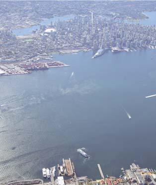
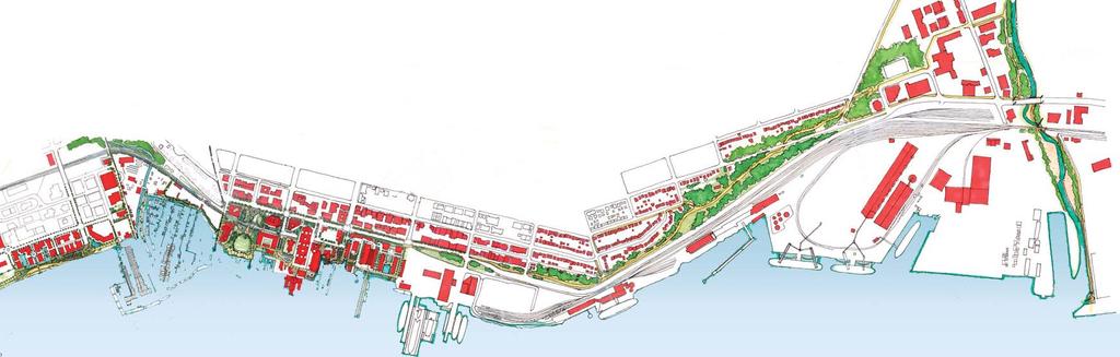
2 INTRODUCTION The City of North Vancouver created the Waterfront Project in 2005 in order to provide a focus for waterfront redevelopment opportunities and preservation of waterfront industries. In 2009, City Council adopted the Waterfront Vision, Goals and Objectives to guide the City s efforts on the waterfont. 1 THE CITY OF NORTH VANCOUVER WATERFRONT VISION, GOALS AND OBJECTIVES 2009


3 I. OVERALL WATERFRONT VISION To create a highly accessible and dynamic waterfront that also supports significant port industry, for the benefit of current and future generations. Foot of Lonsdale Waterfront Park The City s Waterfront Project extends from Lynn Creek on the east to McKay Creek on the west. The west half of our waterfront is shared with the Squamish Nation. The City s portion is intended to become a publicly accessible, active waterfront. The east half of our waterfront is primarily industrial, serving the needs of Canada s Pacific Gateway Port and will remain industrial. Since these two areas have such different characteristics, separate goals and objectives have been prepared for each. 2 THE CITY OF NORTH VANCOUVER WATERFRONT VISION, GOALS AND OBJECTIVES 2009


4 WEST WATERFRONT II. WEST WATERFRONT GOAL To transform the western portion of the City s waterfront into a dynamic Burrard Inlet community amenity and regional tourist attraction. The west waterfront will support economic development with animated commercial uses, programmed piers, parks and open spaces, public attractions and amenities, a continuous harbourwalk and water transportation connections. Waterfront Park Harbourside This portion of the City s waterfront extends from St. George s Avenue to McKay Creek. This includes lands belonging to the Squamish Nation. The Waterfront will connect Lower Lonsdale with the Squamish Nation and Harbourside Business Park. Direct public access along the shoreline will be pursued as a fi rst priority in this area. 3 THE CITY OF NORTH VANCOUVER WATERFRONT VISION, GOALS AND OBJECTIVES 2009


5 WEST WATERFRONT WEST WATERFRONT OBJECTIVES Fell Ave. MacKay Creek Kings Mill Walk Squamish Nation Lands Waterfront Park Esplanade Lonsdale Ave. St.George s SeaBus Terminal Lonsdale Quay Foot of Lonsdale The Shipyards 1. To provide waterfront access with a continuous Harbourwalk that forms part of the Spirit Trail with options for walking, scooters, in-line skating and cycling. 2. To create one or more regional tourist attractions. 3. To provide commercial uses catering to a wide range of needs along the harbourwalk to animate the experience for all users. 4. To provide attractive and useful parks and public open spaces and amenities with a focus on enhanced waterfront experience. 5. To provide for water-based transportation and recreation through a variety of land/water interfaces such as marinas and public docks for short-term visiting vessels, water tours, and programmed activities. 6. To pursue water taxi travel connections both along the North Shore and connecting to Vancouver. 7. To program public open spaces and docks with regular activities to create interest and vibrancy to such an extent that the City becomes a focus for public waterfront activities on Burrard Inlet. 8. To investigate the potential to pursue a vintage streetcar connection from Lonsdale Avenue to Harbourside Drive. 9. To incorporate integrated public art related to the waterfront. 10. To create durable improvements that will be long lasting and to maintain those to a high standard. 11. To build partnerships with the Squamish Nation, property owners, businesses, the waterfront community, public agencies and other levels of government. 12. To protect and enhance the natural forms and dynamics of the City s marine environment and interpret the marine ecosystem to promote its on-going stewardship. 4 THE CITY OF NORTH VANCOUVER WATERFRONT VISION, GOALS AND OBJECTIVES 2009


6 EAST WATERFRONT III. EAST WATERFRONT GOAL To provide public access and waterfront viewing opportunities along the easterly portion of the City s waterfront with strategic points of waterfront access, while retaining port industries. Lynn Creek Moodyville Park The east half of the City s waterfront is part of Port Metro Vancouver. It extends from St. George s Avenue to Lynn Creek. The Port is a gateway for Pacifi c trade and is an integral part of the national economy. Locally, these port lands are a source of employment. Most of the waterfront is owned by the Vancouver Fraser Port Authority and port related industries will remain. Public access will therefore be located north of the industrial lands. The East Waterfront will have a quieter, park-like character with waterfront viewing opportunities. Limited points of direct public access to the waterfront will also be sought, such as at Harbourview Park. 5 THE CITY OF NORTH VANCOUVER WATERFRONT VISION, GOALS AND OBJECTIVES 2009


7 EAST WATERFRONT EAST WATERFRONT OBJECTIVES Lynn Creek St.George s Vancouver Dry Docks Lynnterm Terminals Neptune Terminal Main Street Pioneer Grain Terminal Saskatchewan Wheat Pool 1. To create a continuous greenway corridor for both people and urban wildlife connecting the linear parks and open spaces along the escarpment that defines the City s eastern waterfront edge. 2. To provide viable transportation and recreation options by developing connections to destinations, neighbourhoods, parks, greenways, and designated cycling routes that provide for walking, scooters, in-line skating and cycling. 3. To provide waterfront viewing opportunities. 4. To pursue a public dock at Harbourview Park as a possible water taxi location. 5. To interpret the stories of the working harbour and historic Moodyville site. 6. To integrate public art related to the waterfront. 7. To create durable improvements that will be long lasting and to maintain those to a high standard. 8. To build partnerships with property owners, businesses, public agencies, other levels of government and the waterfront community in this area. 9. To protect and enhance the green escarpment character of the City s eastern waterfront through the sensitive planning of new facilities, management of invasive species, protection of habitat and steep slope environment and rehabilitation of impacted areas. 10. To be sensitive to adjacent residents by minimizing impacts through route selection and design solutions, while also recognizing the broad public benefits of such waterfront amenities. 6 THE CITY OF NORTH VANCOUVER WATERFRONT VISION, GOALS AND OBJECTIVES 2009

8 For more information on the City of North Vancouver Waterfront Project, please visit City of North Vancouver Waterfront Project Offi ce 105 Carrie Cates Court North Vancouver BC, V7M 3J4 Tel: Fax:
Urban Design Principles
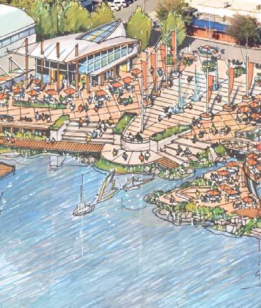
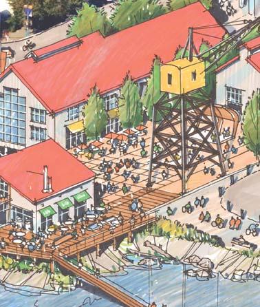
 Urban Design Principles 3.0 Harbouside Waterfront Rezoning Submission - November 2012 3.1 Urban Design Principles Twelve distinct design principles have been identifi ed for the Harbourside Waterfront
10.0 Open Space and Public Realm
 10.0 Open Space and Public Realm 10.0 Open Space and Public Realm The Public Open Space System is comprised of: outdoor spaces available for public use that are either publicly owned (e.g., parks and
New Brighton Park Shoreline Habitat Restoration Project
 Vancouver Board of Parks and Recreation and Port Metro Vancouver New Brighton Park Shoreline Habitat Restoration Project Conceptual Design Public Consultation August 26 September 9, 2015 Discussion Paper
waterfront commercial development opportunity
 the city of north vancouver request for expression of interest the shipyards - lot 5 waterfront commercial development opportunity table of contents PROJECT VISION...3 1.0 INTRODUCTION...4 2.0 BACKGROUND...5
Welcome. Community Consultation Meeting November 28, Review and discuss the Bathurst Quay Neighbourhood Plan Framework
 Welcome Community Consultation Meeting November 28, 2016 Why Are We Here Today? Review and discuss the Bathurst Quay Neighbourhood Plan Framework Review and discuss an Action Plan for Implementation Next
WELCOME WHY A TEMPORARY PATHWAY? WE WANT TO HEAR FROM YOU
 WELCOME In March, the City of Vancouver purchased the lands known as the Arbutus Corridor from Canadian Pacific Railway for the purpose of creating a transportation corridor from False Creek to the Fraser
LAKEVIEW VILLAGE VISION & MASTERPLAN PRESENTATION TO CITY OF MISSISSAUGA. April 9, 2018
 LAKEVIEW VILLAGE VISION & MASTERPLAN PRESENTATION TO CITY OF MISSISSAUGA April 9, 2018 AGENDA Introduction Vision Plan Comparison The Big Moves Trail Connections Plan Overview Districts Conveyance Comparison
{Best Practices. Summary of Tools, Strategies and Best Practices from 11 Michigan Case Study Communities
 Case Studies Michigan Coastal Community Working Waterfronts { Summary of Tools, Strategies and from 11 Michigan Case Study Communities Table of Contents Zoning...2 Community and Stakeholder Collaboration
Highland Falls Waterfront Redevelopment Feasibility Study Village Board Meeting March 20, 2017
 Village Board Meeting March 20, 2017 Agenda I. Public Meeting #1 Visioning Summary II. Public Meeting #2 Comment Summary III. IV. IV. Case Study: Milton Train Station Schematic Design Concepts Schedule/Next
CHAPTER 7: PARKS, OPEN SPACES AND RECREATION
 CHAPTER 7: PARKS, OPEN SPACES AND RECREATION The delivery of Parks and Recreation services in Port Moody aims to provide benefits, either direct or indirect, to all citizens in the community. There is
WILLAMETTE FALLS LEGACY PROJECT
 OPPORTUNITIES & CONSTRAINTS There are here three falls on a line of rocks extending across the river, which forms the bed of the upper channel. The water is precipitated through deep abrazed gorges, and
April 11, 2016 Park Board Chair and Commissioners General Manager Vancouver Board of Parks and Recreation New Brighton Salt Marsh - Preferred Concept
 TO: FROM: SUBJECT: April 11, 2016 Park Board Chair and Commissioners General Manager Vancouver Board of Parks and Recreation New Brighton Salt Marsh - Preferred Concept RECOMMENDATION A. THAT the Vancouver
COMMUNITY HEART HEATHER STREET LANDS
 COMMUNITY HEART PLAZA AT HARVARD, CAMBRIDGE VISUALIZATION OF THE COMMUNITY HEART FROM 33RD AVENUE The concept includes an active mix of uses around open space to support all-day vibrancy. Anchored by the
This page intentionally blank.
 This page intentionally blank. Parks, Recreation, and Open Space Chapter Relationship to Vision Vision Parks, Recreation and Open Space Chapter Concepts County Government. County government that is accountable
1. POPLAR LANDING + MUNI EVERS PARK
 . POPLAR LANDING + MUNI EVERS PARK WHAT S HAPPENING? PROJECT DESCRIPTION PROJECT TIMELINE Poplar Landing and the future Muni Evers Park site (located at 00 Quayside Drive) is jointly owned by the City
OFFICIAL COMMUNITY PLAN
 Richmond OFFICIAL COMMUNITY PLAN City of Richmond BRIDGEPORT AREA PLAN Bylaw 7100 Schedule 2.12 KEY MAP PLAN AREA MAP Original Adoption: March 16, 1992 / Plan Adoption: September 14, 2009 Bridgeport Area
Highest & Best Use Study Marina Park Lands
 Executive Summary of Report MARCH 2006 TABLE OF CONTENTS 1. Introduction...1 2. Study Process...2 3. Highest And Best Use Program...3 4. Concept Plan...8 5. Public Area Animation...9 6. Marina Park Implementation
Municipal Development Plan 2013
 UNIQUELY STONY PLAIN: Municipal Development Plan 2013 Quick Reference Guide What is a Municipal Development Plan (MDP)? The Town s highest-level planning document Sets the long-term vision and key themes
A. Selma Park, Davis Bay and Wilson Creek
 A. Selma Park, Davis Bay and Wilson Creek This waterfront neighbourhood consists of three separate community areas, linked by Highway 101, but with different character, land use patterns and future potential.
Chairman and Members of the Planning and Development Committee. Thomas S. Mokrzycki, Commissioner of Planning and Building
 LA.09.TOR (Toronto) DATE: TO: FROM: SUBJECT: Chairman and Members of the Planning and Development Committee Thomas S. Mokrzycki, Commissioner of Planning and Building Central Waterfront Secondary Plan
COW BAY DEVELOPMENT LANDS
 PRINCE RUPERT PORT AUTHORITY COW BAY DEVELOPMENT LANDS MARCH 28TH, 2012 % of Completion 0 25 50 75 100 4 guiding principles & OBJECTIVES COMMUNITY FEEDBACK BUSINESS & COW BAY MERCHANT FEEDBACK COMMUNITY
Hamilton Pier 7&8 Draft Urban Design Plan
 Hamilton Pier 7&8 Draft Urban Design Plan Public Open House October 29, 2015 Contents 1. Study Overview 2. Area Design Goals 3. Urban Structure 4. Public Realm 5. Urban Design Plan Options 6. Next Steps
City of North Vancouver
 City of North Vancouver PUBLIC ART CALL For Expressions of Interest Mosquito Creek Trail (Bridge Underpass) Deadline: November 10, 2017 @ 4 pm Public Art Mosquito Creek (bridge underpass) Call for Expressions
HBF Marine Study: Victoria Harbour: Water dependent and water related uses and associated land/water interface implications
 HBF Marine Study: Victoria Harbour: Water dependent and water related uses and associated land/water interface implications Presentation on the Initial Findings 9 February 2011 Harbour Business Forum Background
APPENDIX K WINDSOR OFFICIAL PLAN
 CEAA ENVIRONMENTAL ENVIRONMENTAL IMPACT ASSESSMENT AMBASSADOR BRIDGE ENHANCEMENT PROJECT Replacement Span and Plaza Expansion APPENDIX K WINDSOR OFFICIAL PLAN Avalon Consulting Professionals of Ontario,
Cambie Corridor Planning Program Phase Two Draft Plan. Standing Committee on City Services and Budgets May 5, 2011
 Cambie Corridor Planning Program Phase Two Draft Plan Standing Committee on City Services and Budgets May 5, 2011 Cambie Corridor Program Terms of Reference approved July 2009 Land Use Transportation Energy
RECREATION AND OPEN SPACE ELEMENT GOALS, OBJECTIVES, AND POLICIES
 RECREATION AND OPEN SPACE ELEMENT GOALS, OBJECTIVES, AND POLICIES Goal 7 To provide park facilities, recreation programs, and open space resources that are safe, adequate, and accessible to all City residents,
Village of Fair Haven Goals & Objectives
 Village of Fair Haven Goals & Objectives 1 Natural Environmental Quality & Aesthetics Embrace policies and programs that preserve and enhance the Village s natural resources, environment, water quality,
CAMBIE CORRIDOR PLAN
 1 WELCOME TO THE OPEN HOUSE PUBLIC REALM PLAN - CAMBIE CORRIDOR Thank you for coming to the Cambie Corridor Public Realm Open House! Place a dot where you live Please provide us with your comments and
The Master Plan Framework
 The Master Plan Framework The East Harbour Master Plan advances the development of 60 acres of former industrial lands east of the Don River. The Master Plan outlines a vision for a vibrant, transit-oriented
PORT UNION VILLAGE COMMUNITY SECONDARY PLAN
 4 PORT UNION VILLAGE COMMUNITY SECONDARY PLAN 4. PORT UNION VILLAGE COMMUNITY SECONDARY PLAN The following policies and principles apply to the area herein referred to as Port Union Village, as outlined
Thank you for coming to the Rail Corridor Land Use Study Public Meeting.
 01 Welcome! Thank you for coming to the Rail Corridor Land Use Study Public Meeting. Tonight is an opportunity to learn about the Land Use Study for the Rail Corridor Site. In Fall 2016, Toronto City Council
Hamilton Pier 7&8 Public Meeting and Workshop #1
 Hamilton Pier 7&8 Public Meeting and Workshop #1 May 12, 2015 May 01, 2015 Meeting Agenda 6:30 Doors Open 6:30-6:45 Review Boards 6:45-7:10 Introductions and Presentation Study Overview Policy Background
Table 8-4: Road Classification Local Roads, second table, of Chapter 8 Create a Multi-Modal City, be amended by adding the following:
 1 Port Street East Official Plan Amendment APPENDIX 3 Amendments to Mississauga Official Plan Table 8-4: Road Classification Local Roads, second table, of Chapter 8 Create a Multi-Modal City, be amended
3.1 Existing Land Use
 3.0 Land Use This strategy has been developed taking into account the position of the Town of Sidney as the economic center of the Saanich Peninsula. It acknowledges existing land use patterns in the downtown
VANCOUVER CONVENTION CENTRE EXPANSION PROJECT (VCCEP) SUPPLEMENTARY BULLETIN: * WATER-ORIENTED DEVELOPMENT
 SUPPLEMENTARY BULLETIN: * WATER-ORIENTED DEVELOPMENT") City of Vancouver Planning - By-law Administration Bulletins Community Services, 453 W. 12th Ave Vancouver, BC V5Y 1V4 F 604.873.7344 fax 604.873.7060 planning@vancouver.ca VANCOUVER CONVENTION CENTRE
City of Vancouver Planning - By-law Administration Bulletins Community Services, 453 W. 12th Ave Vancouver, BC V5Y 1V4 F 604.873.7344 fax 604.873.7060 planning@vancouver.ca VANCOUVER CONVENTION CENTRE
AMBLESIDE WATERFRONT
 Overview: An Integrated Vision for the Waterfront The waterfront concept plan shown above is the result of 40 years of acquiring, planning and improving a publicly-owned waterfront. Consistent community
WELCOME! WHAT IS A GREENWAY?
 WELCOME! In March 2016, the City of Vancouver purchased 42 acres of land from Canadian Pacific Railway for the purpose of creating a high-quality public space for walking, cycling and wheeling. Streetcar
Toronto Waterfront Revitalization
 Toronto Waterfront Revitalization Toronto Waterfront Revitalization Corp. Established 2001 Tripartite - Government of Canada, Province of Ontario, City of Toronto Master developer, comprehensive integrated
Animating the Rideau Canal December 2013
 Executive Summary Animating the Rideau Canal December 2013 Why study the Rideau Canal? The Rideau Canal has been an important part of Ottawa throughout its history, and has shaped and been shaped by the
As is referenced in the site analysis, the current site access is along Loggers Lane and on to Galbraith Avenue.
 4.12 Archaeological Assessment The land above sea level at the Oceanfront was created over the last 100 years by the fill from dredging of the Mamquam Blind Channel, the Cattermole Slough and the Squamish
Queensborough Eastern Neighbourhood Node. Community Open House
 Queensborough Eastern Community Open House The Vision The Queensborough Eastern will become the heart of eastern Queensborough. Through a sensitive mix of viable commercial and residential areas, the neighbourhood
Coastal Smart Growth Approaches for Working Waterfront Preservation, Implementing Locally-Based Strategies and Solutions
 Coastal Smart Growth Approaches for Working Waterfront Preservation, Implementing Locally-Based Strategies and Solutions National Working Waterfronts Symposium March 26, 2013 Presented by: Lydia Bennett
City of North Vancouver. Official Community Plan. WORKING DRAFT December 3, 2013
 City of North Vancouver Official Community Plan WORKING DRAFT December 3, 2013 Acknowledgements The City also wishes to recognize the contributions made by the thousands of community members who actively
WEST HARBOUR VISION DRAFT 1.0
 CONTEXT WEST HARBOUR VISION DRAFT 1.0 Historic West Harbour has been the arrival point, the departure point, and a meeting place for generations of people. Many have made the West Harbour communities of
DRAFT. Waterfronts and Open Spaces. 10 The Riverfront Open Space System
 CHAPTER 4 Waterfronts and Open Spaces 10 The Riverfront Open Space System 12 Planned, proposed and envisioned riverfront recommendations. Figure 4.3.23 The riverfront will become a major new public amenity
The Planning Partnership Baird + Associates TCI Management Consultants Ltd. Plan B Natural Heritage Wills Consulting Engineers Poulos & Chung Limited
 Little Lake Master Plan The Planning Partnership Baird + Associates TCI Management Consultants Ltd. Plan B Natural Heritage Wills Consulting Engineers Poulos & Chung Limited May 26, 2009 Purpose of Study
SECTION ONE: INTRODUCTION. introduction
 introduction 1 INTRODUCTION Since it was first established in 1843 as a trading post for the Hudson s Bay Company, Victoria has evolved into a Provincial capital city that is recognized across Canada and
Town of Whitby Waterfront Parks and Open Space Master Plan Final Report, January 2016
 CMS 20-16 Attachment #1 Town of Whitby Waterfront Parks and Open Space Master Plan Final Report, January 2016 Table of Contents Waterfront Master Plan Study Overview i Introduction 1 Overall Waterfront
Edward R. Sajecki Commissioner of Planning and Building
 Corporate Report Clerk s Files Originator s Files CD.03.POR DATE: TO: FROM: SUBJECT: Chair and Members of Planning and Development Committee Meeting Date: February 27, 2012 Edward R. Sajecki Commissioner
Pinellas County Greenways
 Pinellas County Greenways USING GREENWAYS TO LINK OPEN SPACES The Florida Greenways Commission has defined a greenway as...a corridor of protected open space that is managed for conservation and/or recreation.
2.0 Regional Context Statement
 2.0 Regional Context Statement REGIONAL CONTEXT STATEMENT Part 10 of the Municipalities Enabling and Validating Act (No.3) (MEVA), requires UBC to include a Regional Context Statement in a Land Use Plan.
QUEEN-RIVER SECONDARY PLAN
 34 QUEEN-RIVER SECONDARY PLAN 34. QUEEN RIVER SECONDARY PLAN 1. INTRODUCTION The Queen-River area is approximately 6.4 hectares and is located at the eastern edge of the Downtown as shown on Map 34-1.
City Center Neighborhood Plan
 [1] City Center Neighborhood Plan As adopted by Ordinance No. 2014-09-049 and amended by Ordinance Nos. Formerly CBD Neighborhood as adopted by Ordinance No. 8868 and amended by Ordinance Nos. 8946, 9693,
M-NCPPC Park System in
 Park Planning & Stewardship Division Park & Trail Planning Section East County Science Center Master Plan Parks, Recreation, Trails, and Open Space- Issues and Opportunities PARK PLANNING & STEWARDSHIP
1. Parks & Recreation Neighborhood Parks Community Parks Special Use Sites 2. Open Space 3. Trails
 Appendix A: Park Classifications The intent of parks and recreation classifications is to aid in making acquisition and design decisions for park sites, facilities and the organization of recreation space
Moody Centre Station TOD Area Today
 Moody Centre Station TOD Area Today WHAT IS a transit-oriented Murray Street development area? A Transit-Oriented Development (TOD) Area is a dense, walkable residential and commercial area built to support
2009 Waterfront Strategy Redefining living on the edge... Adopted: February 9, 2009
 2009 Waterfront Strategy Redefining living on the edge... Adopted: February 9, 2009 January 6, 2009 City of Richmond Prepared by: Yvonne Stich - Park Planner, Parks Division Publication Design: Christina
City of Vancouver Regional Context Statement Official Development Plan. (Adopted by By-law No , September 24, 2013)
") City of Vancouver Regional Context Statement Official Development Plan (Adopted by By-law No. 10789, September 24, 2013) Table of Contents Introduction GOAL 1 Create a Compact Urban Area STRATEGY 1.1
City of Vancouver Regional Context Statement Official Development Plan (Adopted by By-law No. 10789, September 24, 2013) Table of Contents Introduction GOAL 1 Create a Compact Urban Area STRATEGY 1.1
3.5 Principle 5/Response
 5 Principle 5/Response Existing street network Proposed street network Pedestrian street hierarchy Existing streets Existing Regional Arterial 4 Existing Street Network Existing and proposed streets Indicative
The Proposed Auckland Unitary Plan (notified 30 September 2013)
") 3 Business zones Introduction There are 10 business zones in the Unitary Plan: City Centre Metropolitan Centre Town Centre Local Centre Neighbourhood Centre Mixed Use General Business Business Park Light
3 Business zones Introduction There are 10 business zones in the Unitary Plan: City Centre Metropolitan Centre Town Centre Local Centre Neighbourhood Centre Mixed Use General Business Business Park Light
Keyport. Vision for Keyport
 Keyport Vision for Keyport Keyport is a rural, historic waterfront village bounded and limited in size by its natural borders of water and the Naval Undersea Warfare Center. The community consists primarily
A Growing Community Rural Settlement Areas
 Town of Huntsville Official Plan Review - POLICY BACKGROUND PAPER A Growing Community Rural Settlement Areas BACKGROUND: In addition to the fully municipally-serviced Urban Settlement Area and the Hidden
2.1 Location and Size
 2.0 Context 7 2.1 Location and Size The Saanich Penninsula The study area is centrally located within the Town boundaries on the east side of Highway 17, which runs through Sidney in a north-south direction.
DOWNTOWN PARKS & PUBLIC REALM PLAN
 DOWNTOWN PARKS & PUBLIC REALM PLAN CHALLENGES The Parks and Public Realm Strategy addresses challenges associated with a growing Downtown, including: GOALS 3.3 New buildings will fit within their existing
City of Surrey Ecosystem Management Study. Integration of ecological processes with land use
 City of Surrey Ecosystem Management Study Integration of ecological processes with land use Natural areas in Surrey are changing as the City grows and evolves. Many important natural areas remain or may
HE VISION. Building a Better Connected Place
 HE VISION Building a Better Connected Place WALK INTO THE FUTURE. Life in Cranberry, 2030 Here s what our residents told us they wanted to see in their community by 2030: The Cranberry of 2030 is a place
Public Workshop #2 October , Welcome. Former Kingston Penitentiary & Portsmouth Olympic Harbour
 Public Workshop #2 October 12 + 13, 2016 Welcome Former Kingston Penitentiary & Portsmouth Olympic Harbour Cataraqui Golf and Country Club Portsmouth Avenue St. Lawrence College Sir John A. Macdonald Blvd
QUESTION 8: What are your Public Realm priorities for implementation? What would you like to see happen first? TELL US WHAT YOU THINK
 Public Realm Plan How will the Public Realm Plan be implemented? The Public Realm Plan document will set out a vision for the next 30 years. Over time, Plan elements and aspects can be implemented as opportunities
VANCOUVER CONVENTION AND EXHIBITION CENTRE (VCEC) CD-1 GUIDELINES THURLOW STREET. Adopted by City Council November 5, 2002
 CD-1 GUIDELINES THURLOW STREET. Adopted by City Council November 5, 2002") $2 Land Use and Development Policies and Guidelines Community Services, 453 W. 12th Ave Vancouver, BC V5Y 1V4 F 604.873.7344 fax 873.7060 planning@city.vancouver.bc.ca VANCOUVER CONVENTION AND EXHIBITION
$2 Land Use and Development Policies and Guidelines Community Services, 453 W. 12th Ave Vancouver, BC V5Y 1V4 F 604.873.7344 fax 873.7060 planning@city.vancouver.bc.ca VANCOUVER CONVENTION AND EXHIBITION
Parks, Open Space and Trails
 Introduction Parks have often been referred as the lungs of our cities, cleansing the air of pollutants and particulate matter. Parks are also gathering places for families and community. They offer spaces
George Hotel application STAFF REVIEW COMMITTEE OF THE WHOLE JANUARY 14, 2014
 George Hotel application STAFF REVIEW COMMITTEE OF THE WHOLE JANUARY 14, 2014 1 Presentation outline Purpose: to seek Council direction for next steps in the review process Application process to date
Lakeview. March 18, N. Barry Lyon Consultants Ltd. UEM TMIG
 Lakeview March 18, 2014 N. Barry Lyon Consultants Ltd. UEM TMIG Mississauga s Waterfront A Coordinated Approach mississauga.ca/waterfront Mississauga s Waterfront - Projects Natural Heritage and Urban
GUIDELINES EXHIBITION PLACE LOCATION: OBJECTIVES. Structure Plan URBAN DESIGN GUIDELINES
 Development in the Exhibition Place lands will be consistent with the following urban design guidelines. They provide a framework for new development of the lands and are to be read in conjunction with
Little Neck Planning Area
 Little Neck Planning Area Current Reality The Little Neck Planning Area is characterized by established residential neighborhoods, Town Center and Pembroke. The Eastern and Western Branches of the Lynnhaven
Hobart A Strategic Framework
 Hobart 2025 A Strategic Framework Adopted by the Hobart City Council 15 October 2007 Table of Contents Introduction...2 Vision and Future Directions...3 FD1 Offers opportunities for all ages and a city
City of Poughkeepsie Waterfront Redevelopment Strategy. Poughkeepsie Waterfront Redevelopment Strategy
 City of Poughkeepsie Waterfront Redevelopment Strategy Poughkeepsie Waterfront Redevelopment Strategy City of Poughkeepsie Prime Assets: Major Waterfront Advantages: - Central City of the Hudson River
CHAPTER ONE INTRODUCTION
 1.0 Introduction Bellingham s central waterfront is in a state of transition from its long history as an active industrial site to a new mixed-use neighborhood. Over the past several years, the Port of
A Vision Statement. In Progress
 A Vision Statement A Vision Statement A vibrant, multicultural, walkable neighbourhood comprised of distinct areas, each with its own special character. A Vision Statement A vibrant, multicultural, walkable
Park Board Strategic Framework. (Mission, Vision, Directions, Goals and Objectives) June 27, 2012
 June 27, 2012") Park Board Strategic Framework (Mission, Vision, Directions, Goals and Objectives) June 27, 2012 Planning Process Overview Phase 1: Renewed Strategic Framework Phase 2: Objectives Phase 3: Prioritization
Park Board Strategic Framework (Mission, Vision, Directions, Goals and Objectives) June 27, 2012 Planning Process Overview Phase 1: Renewed Strategic Framework Phase 2: Objectives Phase 3: Prioritization
We are a determined group residents, industry, and government and by working together an incredible future lies ahead for Troy.
 PROPOSED EDITS TO COMPREHENSIVE PLAN April 5, 2018 Page Par Change Iv TOC Principle 2, page number is 3 should be 33 I Forward Par 3, delete Strike through: Troy is today experiencing 3 1.1 Par 3 change
PORT WHITBY COMMUNITY
 PORT WHITBY COMMUNITY SECONDARY PLAN UPDATE COMMUNITY IMPROVEMENT PLAN URBAN DESIGN GUIDELINES September 2015 DRAFT PROPOSED AMENDMENT NUMBER # to the Whitby Official Plan PURPOSE: The intent of this Amendment
PARKS. Chapter Introduction
 Chapter 4. PARKS 4.1. Introduction This Parks Element of the 2016 Comprehensive Plan Update provides direction and guidance, based on citizen input, in order to improve and maintain the City s existing
RIVERSIDE DESIGN CD-1 GUIDELINES. Adopted by City Council August 9, 1983
 $1 City of Vancouver Land Use and Development Policies and Guidelines Community Services, 453 W. 12th Ave Vancouver, BC V5Y 1V4 F 604.873.7344 fax 873.7060 planning@city.vancouver.bc.ca RIVERSIDE DESIGN
Zoning and Development Considerations in the Boothbay Harbor Maritime/Water Dependent District
 Zoning and Development Considerations in the Boothbay Harbor Maritime/Water Dependent District Bob Faunce Lincoln County Planner Lincoln County Regional Planning Commission Board of Selectmen and Planning
Park Board Chair and Commissioners General Manager Vancouver Board of Parks and Recreation Love Locks Concept Plan
 Date: June 30, 2015 TO: FROM: SUBJECT: Park Board Chair and Commissioners General Manager Vancouver Board of Parks and Recreation Love Locks Concept Plan RECOMMENDATION A. THAT the Vancouver Park Board
Two Things... that you love about the City of North Vancouver
 Two Things... that you love about the City of North Vancouver The City nature Lots of good forests to walk in Safe and friendly Proximity of the City to nature and the good community of people Close to
Candlestick Point SRA Yosemite Slough Restoration Project. Presented by
 Candlestick Point SRA Yosemite Slough Restoration Project Presented by Yosemite Slough Restoration Project The Center of a Revitalized Waterfront in Southeastern San Francisco The Yosemite Slough Restoration
Appendix 4 Park, Trail, and Recreation Facilities For more information, call the Park Planning and Stewardship Division at
 Appendix 4 Park, Trail, and Recreation Facilities For more information, call the Park Planning and Stewardship Division at 301-650-4380 montgomery county planning board maryland-national capital park and
Planning and Public Consultation Process for the Preparation of a General Land Use Plan for South Port Kells TERMS OF REFERENCE
 APPENDIX "B" Planning and Public Consultation Process for the Preparation of a General Land Use Plan for South Port Kells TERMS OF REFERENCE PURPOSE South Port Kells is located in the northeastern quadrant
2.0 Urban Design Concepts
 0 Urban Design Concepts Urban Design Concept diagrams The Waterfront Axis The Park Axis The Wharf Axis Waterfront Precincts 0.1 The Four Key Concepts: This Concept for the Wynyard Quarter establishes four
CITY OF VAUGHAN KIRBY GO TRANSIT HUB SUB-STUDY
 WELCOME! Thank you for attending, and welcome to the first of three Public Meetings for the Kirby GO Transit Hub Study. Your feedback is important to us, and will help inform the development of the draft
DEFINED VILLAGE CENTRES & NEIGHBOURHOODS
 DEFINED VILLAGE CENTRES & NEIGHBOURHOODS residents in Nanoose Bay support focusing attractive, planned future development in Red Gap Centre and the Area s neighbourhood centres. In addition, the development
Chapter 1. Community Context. Vision Statement Population and Housing Trends Legislative Context Regional Context Statement
 Chapter 1 Community Context Vision Statement Population and Housing Trends Legislative Context Regional Context Statement 1.1 VISION STATEMENT CORPORATE MISSION STATEMENT To promote a safe and livable
Town of Cobourg Heritage Master Plan. Statutory Public Meeting
 Town of Cobourg Heritage Master Plan Statutory Public Meeting April 25 th 2016 Presentation Overview 1. Introduction 2. Project background and schedule overview 3. Review of strategic direction content
Corridor Vision. 1Pursue Minnehaha-Hiawatha Community Works Project. Mission of Hennepin County Community Works Program
 1Pursue Minnehaha-Hiawatha Community Works Project Minnehaha-Hiawatha Community Works is a project within the Hennepin Community Works (HCW) program. The mission of the HCW program is to enhance how the
Somers Point Master Plan
 Somers Point Master Plan Progress Report and Public Meeting August 20, 2014 Master Plan Reexamination Municipal Land Use Law require that all municipalities reexamine their master plan every ten years.
CENTRAL WATERFRONT OFFICIAL DEVELOPMENT PLAN. Table of Contents
 ENTRAL WATERFRONT OFFIIAL DEVELOPMENT PLAN (Adopted by By-law No. 5261, June 19, 1979) Table of ontents Page Preamble... 3 Section 1 Application and Intent... 6 Section 2 Definitions... 9 Section 3 Overall
TASK FORCE MEETING #6 SUMMARY
 TASK FORCE MEETING #6 SUMMARY CITY OF REDWOOD CITY INNER HARBOR SPECIFIC PLAN Tuesday, January 14, 2013 7:00 P.M. 9:30 P.M. Seaport Conference Center, 459 Seaport Court, Redwood City, CA 94063 I. WELCOME
jmt.com MARINE Part of a diversified family of solutions
 jmt.com MARINE Part of a diversified family of solutions Services Marine & Coastal Engineering Modeling Coastal Initiatives & Techniques Port, Harbor, & Marine Consultancy Small Craft Design Permitting