San Francisco Bay Pilot: Sausal Creek Community Leader Charrette May 11, 2016 Marcus Griswold
|
|
|
- Lorraine Lawson
- 5 years ago
- Views:
Transcription


1 San Francisco Bay Pilot: Sausal Creek Community Leader Charrette May 11, 2016 Marcus Griswold 1

2 Overview Project Overview Watershed Context Assets and Challenges Opportunities Green Streets Creek Access Art and Trail Connections Community Discussion Skeo Solutions Walkable Watersheds Pilot 2
3 Sausal Creek Team Friends of Sausal Creek National Park Service City of Oakland California State University Unity Council Skeo All of you! Skeo Solutions Walkable Watersheds Pilot 3

4 Purpose Develop a shared vision, set of strategies and concept plan to improve watershed and neighborhood health. Skeo Solutions Walkable Watersheds Pilot 4


5 Sausal Creek Watershed All land draining to Sausal Creek Substantial watershed improvements above 580 Walkable Watershed focused on area below 580 Skeo Solutions Walkable Watersheds Pilot 5
6 Project Study Area Includes: Dimond, Wood and Josie de la Cruz Parks Fruitvale and Dimond neighborhoods Stormwater flows to the creek, and out to the estuary at Fruitvale Bridge Park. Much of the creek is piped below ground. Skeo Solutions Walkable Watershed Pilot 6


7 What is a Walkable Watershed? An approach to watershed planning that links environmental and social equity goals. Celebrates the creek as a catalyst for community revitalization by integrating investments in watershed and neighborhood stewardship. Fruitvale Village TOD Skeo Solutions Walkable Watershed Pilot 7

8 Walkable Watershed Process 1. Bring stakeholders together. 2. Develop a shared understanding of both the technical and the community based issues. 3. Identify strategies that improve conditions for both pedestrians and water quality. 4. Unify strategies into a cohesive vision to leverage funding and partnerships for implementation. Skeo Solutions Walkable Watershed Pilot 8
9 Project Goals Improve connectivity across the watershed and engage a broad cross section of the community Utilize art to highlight the importance and history of the underground stream system Engage local schools and provide accessible educational, bilingual information to community members on the benefits of the watershed Leverage City of Oakland plans and requirements: Urban Greening requirements and Fruitvale Improvement Plan, and others! Skeo Solutions Walkable Watershed Pilot 9

 Skeo Solutions Walkable Watershed Pilot")
10 Project Schedule January-March: Information Gathering April: Challenges and Opportunities May-July: Stakeholder Forums July-September: Final Plan Sausal Creek at the Estuary 22 nd St (Austin Square) Skeo Solutions Walkable Watershed Pilot 10

11 Outcome Combine strategies into a larger concept plan that represents a shared vision among diverse stakeholders. Provides a roadmap to guide investments and engage a range of partners and funding sources. Skeo Solutions Walkable Watershed Pilot 11
12 Assets and Challenges Skeo Solutions Walkable Watershed Pilot 12

13 Community Assets Parks: Josie de la Cruz, Wood and Fruitvale Bridge Park Schools: Redwood Day School, Manzanita SEED and Community School, Achieve, Urban Promise, ARISE, Epic, ERES Academy Community Organizations Businesses Health and Community Centers Fruitvale Village Skeo Solutions Walkable Watershed Pilot 13


14 Challenges Mobility and Safety Perception that walking in neighborhood and parks is not safe Integrated bike lanes not seen as safe Potholes and damaged roads along major intersections 580 Underpass 25 th Street Skeo Solutions Walkable Watershed Pilot 14


15 Challenges Watershed Awareness and Access Unaware of creek Creek inaccessible and fenced off Illegal dumping and crime at creek crossings and at intersections Storm drain clogs near creek Parking lots and streets drain directly to stream Potential creek access at Peroly Ct Potential Creek access at 22 nd Street Potential Creek access at Josie de la Cruz Park Skeo Solutions Walkable Watershed Pilot 15
16 Opportunities Green Streets Creek Access Art and Trail Connections Schools and Civic Spaces Skeo Solutions Walkable Watershed Pilot 16

17 Green Streets: Community Connections Transportation Plans Pedestrian Plan Bike Plan Corridor Nodes Public transit connections Safe Routes to Schools Urban Greening/Green Streets Skeo Solutions Walkable Watershed Pilot 17

")
18 Green Streets: Full street coverage Fruitvale Ave and Foothill Blvd: Part of Oakland s Urban Greening program. Potential opportunities for protected bike lanes, swales and safe crossings. Potential green streets design for 90 foot right of way (Fruitvale is 80 ) Skeo Solutions Walkable Watershed Pilot 18


19 Green Streets: Swales 23 rd Street: Swales are planted channels that trap excess water from streets. They can reduce flooding and clean water before it goes to creeks. 23 rd Street near Sausal creek Curb extension retrofit Skeo Solutions Walkable Watershed Pilot 19


20 Green Streets: Safe Crossings Stormwater capture along streets can create safe access for all people and enhance water quality by cleaning stormwater runoff. Fruitvale Avenue Safe crossing and stormwater capture Skeo Solutions Walkable Watershed Pilot 20


21 Green Streets: Cul-de-sacs Peroly Court: Cul-de-sacs provide an opportunity to catch and clean water before reaching the creek while beautifying unused areas. Peroly Court cul-de-sac abuts large parking lot for health center Cul-de-sac with vegetated bioswale Skeo Solutions Walkable Watershed Pilot 21
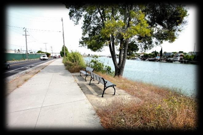
22 Creek Access Viewpoints at cul-desacs and crossings provide opportunities for Parklets and benches Signage and artwork Neighborhood stewardship Skeo Solutions Walkable Watershed Pilot 22


23 Creek Access: Crossings Hyde and 25th Street: New creek crossings can connect separated neighborhoods and increase access to community assets. Potential Sausal Creek Crossing at 25 th Street Sausal Creek Crossing at Bridgeview Skeo Solutions Walkable Watershed Pilot 23


24 Creek Access: Viewpoints Cul-de-sacs and Crossings: Improving creek views and overlooks connects to our senses and can improve health and wellness. Creek View at Josie de la Cruz Park Creek Viewpoint College Township, PA Skeo Solutions Walkable Watershed Pilot 24


25 Creek Access: Viewpoints Peroly Court: Public land near Manzanita School could provide green space between Wood and Josie de la Cruz Parks. Naturebased play spaces could connect families to their environment. Peroly Court Creek Access Natural play spaces and overlooks Skeo Solutions Walkable Watershed Pilot 25


26 Creek Access: Daylighting Buried Streams William Wood Park: Bringing buried streams to life again restores wildlife and water quality and increases awareness. Buried Stream in William Wood Park Daylighted Thornton Creek in Seattle Skeo Solutions Walkable Watershed Pilot 26


27 Art and Trail Connections: Celebrating the Watershed Bridge reflects skeleton of native fish Carrington Steps near Peralta Creek Painted Sausal Creek at Urban Promise Skeo Solutions Walkable Watershed Pilot 27


28 Art and Trail Connections Skeo Solutions Walkable Watershed 28


29 Art and Trail Connections: Underpasses 580 Overpass connection from Dimond Park to Wood Park Undergardiner community space in Toronto Underpass at Fruitvale and 880 The Underline beneath Miami s Metro Skeo Solutions Walkable Watershed Pilot 29


30 Art and Trail Connections: Signage and Plantings Fruitvale Ave Rail Right of Way: Plantings, art and signage can improve walking experiences and water quality by trapping chemicals in runoff. Rail Right of Way on Fruitvale, adjacent to Fruitvale Station Along pedestrian routes with educational signage Skeo Solutions Walkable Watershed Pilot 30


31 Art and Trail Connections: On-street Protected underpass trail (Atlanta) On street trail Green/Edible wall Cultural signage Skeo Solutions Walkable Watershed Pilot 31


32 Schools and Civic Spaces: Drop-off zones Achieve Academy: Outdated infrastructure near schools provides an opportunity for safe routes, improved water quality and environmental education. Potholes Broken asphalt Stormwater inlet 29 th Ave and E. 17 th Street: Achieve Academy Stormwater planter cleans water from roads before reaching creeks Skeo Solutions Walkable Watershed Pilot 32


33 Schools and Civic Spaces: Buildings Josie de la Cruz Park (Carmen Flores Recreation Center): Capture rain from roof to irrigate future tree grove. Rain barrels and cisterns can store months of irrigation water from roofs. Future tree planting Skeo Solutions Walkable Watershed Pilot 33


34 Schools and Civic Spaces: Parking Lots Parking lots drain stormwater directly into the creek Bioretention and rain gardens can clean stormwater with a minimal footprint Skeo Solutions Walkable Watershed Pilot 34
35 Next Steps Gather input today Gather input during youth session Share ideas with City and County Draft Sausal Creek draft walkable watershed plan Present draft to broader public Skeo Solutions Walkable Watershed Pilot 35
36 Questions? Skeo Solutions Walkable Watershed Pilot 36

37 Contact Information Marcus Griswold Walkable Watershed San Francisco Bay Coordinator Skeo Solutions Skeo Solutions Walkable Watershed Pilot 37
SAUSAL CREEK WALKABLE WATERSHED CONCEPT PLAN
 SAUSAL CREEK WALKABLE WATERSHED CONCEPT PLAN healthy waters : healthy communities Oakland California 2016 PROJECT BACKGROUND Introduction The Sausal Creek Walkable Watershed Concept Plan is an invitation
Potential Green Infrastructure Strategies May 6, 2015 Workshop
 Potential Green Infrastructure Strategies May 6, 2015 Workshop Background The City of Cortland is developing the Tioughnioga Urban Headwaters Green Infrastructure Action Plan with funding from the National
Public Meeting May 20, 2014
 Public Meeting May 20, 2014 Overview Study Purpose Study Area Overview Strategies Potential Opportunities Implementation and Discussion Skeo Solutions Raleigh Walkable Watershed Pilot 2 Purpose Develop
CHAPTER 8. Mrs. Zimman s Class - Central Elementary
 SUSTAINABILITY CHAPTER 8 Mrs. Zimman s Class - Central Elementary 8.1 OVERVIEW Green infrastructure also known as low impact development (LID) and environmental or sustainable site design is an environmentally
Sustainability, Health, Safety, Recreation & Open Space Working Group August 3, 2017
 Sustainability, Health, Safety, Recreation & Open Space Working Group August 3, 2017 DOWNTOWN OAKLAND SPECIFIC PLAN WELCOME Sustainability, Health, Safety, Recreation & Open Space Working Group Social
Subregion 4 Central Avenue-Metro Blue Line Corridor Transit-Oriented Development (TOD) Implementation Project. Community Meeting April 27, 2011
 Implementation Project. Community Meeting April 27, 2011") Subregion 4 Central Avenue-Metro Blue Line Corridor Transit-Oriented Development (TOD) Implementation Project Community Meeting April 27, 2011 Overview Introduction to Subregion 4 TOD Implementation Program
Subregion 4 Central Avenue-Metro Blue Line Corridor Transit-Oriented Development (TOD) Implementation Project Community Meeting April 27, 2011 Overview Introduction to Subregion 4 TOD Implementation Program
Green Streets. Sustainable Stormwater Solutions for Greener Communities and a Cleaner Bay
 Green Streets Sustainable Stormwater Solutions for Greener Communities and a Cleaner Bay As the Bay Area continues to grow through development of roads, revitalization of neighborhoods, and construction
Bruce Adams, Waste Water Treatment Plant Operations Manager, City of Cortland Chris Bistochi, Public Works Director, City of Cortland
 MEMORANDUM (DRAFT) Date: January 14, 2014 To: Mack Cook, Director of Administration and Finance, City of Cortland Chris Bistochi, Director of Public Works Department, City of Cortland Amanda Barber, Cortland
JANUARY 19, 2011 CENTRAL AVENUE-METRO BLUE LINE TRANSIT-ORIENTED DEVELOPMENT IMPLEMENTATION PROJECT COMMUNITY FORUM
 CENTRAL AVENUE-METRO BLUE LINE TRANSIT-ORIENTED DEVELOPMENT IMPLEMENTATION PROJECT COMMUNITY FORUM JANUARY 19, 2011 THE MARYLAND-NATIONAL CAPITAL PARK AND PLANNING COMMISSION PRINCE GEORGE S COUNTY PLANNING
LEED-ND 101: Practical Strategies for Achieving Sustainability Goals. Travis Parker Lakewood Planning Director
 LEED-ND 101: Practical Strategies for Achieving Sustainability Goals Travis Parker Lakewood Planning Director Metro Vision Idea Exchange Oct 11, 2012 West Corridor Stations West Corridor Overview West
New Partners for Smart Growth Conference February 5, 2010
 Dan Stroh, Planning Director City of Bellevue Planning and Community Development Bellevue, WA New Partners for Smart Growth Conference February 5, 2010 Summary of Project Long-range plan update for Bel-Red
A BLUEPRINT FOR BROCKTON A CITY-WIDE COMPREHENSIVE PLAN
 A BLUEPRINT FOR BROCKTON A CITY-WIDE COMPREHENSIVE PLAN Public Meeting October 2016 1 Plan Summary and Discussion Public Meeting May 4 2017 City of Brockton Bill Carpenter, Mayor Department of Planning
AREA-WIDE PEDESTRIAN AND BICYCLE CIRCULATION
 OUSD LANEY CHILD CARE CENTER ART BUILDING LANEY COLLEGE BALL FIELDS PCCD OFFICES PERALTA PARK AQUATIC CENTER & ESTUARY PARK EDOFF MEMORIAL BANDSTAND SNOW PARK COURT HOUSE OAKLAND MUSEUM OAK ST AREA-WIDE
A larger version of this map is located on the last page of this PDF.
 MAP Committee Input McLoughlin Area Draft Vision Map A larger version of this map is located on the last page of this PDF. 1. The map above is intended to portray a vision for the McLoughlin area. It highlights
Atlanta BeltLine. Subareas 9 & 10. Master Plan Updates. March 26, Washington Park Jamboree 1
 Atlanta BeltLine Subareas 9 & 10 Master Plan Updates March 26, 2018 Washington Park Jamboree 1 22 miles, connecting 45 neighborhoods 22 MILES of transit 46 MILES of streetscapes and complete streets 33
Transportation. Strategies for Action
 Transportation A major priority for the Overlake Neighborhood is to develop a multimodal transportation system. To achieve this system, a balance has to be found among travel, circulation and access needs;
PLAN ELEMENTS WORKSHOP. April 5, 2016
 PLAN ELEMENTS WORKSHOP April 5, 2016 needs more housing. But there is no one-size fits-all solution. Every neighborhood has its own character. In some places, density is not only appropriate it is badly
Sustainable Storm Water Management
 Incorporating Water Management into the Community Planning Process August 16, 2012 Sustainable Storm Water Management Samantha Brown Environmental Engineer SD1 SD1 s Service Area CVG Airport SD1 Service
Preliminary Recommendations Tk Takoma/Langley Crossroads Sector Plan
 Preliminary Recommendations Tk Takoma/Langley Crossroads Sector Plan Vision is to achieve a Transit Oriented, pedestrian friendly Community that Celebrates and builds upon the cultural Diversity of the
2011 ASLA Design Awards. Westside Creeks Restoration Plan Merit Award AECOM, Fort Collins. Planning & Urban Design
 2011 ASLA Design Awards Westside Creeks Restoration Plan Merit Award AECOM, Fort Collins Planning & Urban Design Project Fact Sheet Category of Entry: Rotating Specialty Award: 2011 2011 ASLA Colorado
City of Tacoma Planning and Development Services
 Agenda Item E-1 City of Tacoma Planning and Development Services To: Planning Commission From: Elliott Barnett, Planning Services Division Subject: Tacoma Mall Regional Center Subarea Plan and EIS Meeting
Green Infrastructure Basics
 1 Green Infrastructure Basics Emily Vail Hudson River Estuary Program NYS Department of Environmental Conservation New York State Water Resources Institute at Cornell University December 8, 2016 2 Presentation
Urban Greening Plan Proposed Policies and Programs Matrix Existing City Plans and Goals Programs Policies Notes/Comments
 Urban Greening Plan Circulation Plan for Bicyclists and Pedestrians (2007) 1.1 - Develop a coordinated Trail Maintenance Volunteer Program that identifies funding and leverages community efforts and partnerships
Study Area. Capitol Way. Greening America s Capitals 11/13/2014. A Greening America s Capitals Project
 Olympia, WA: Greening Capitol Way Supporting Communities move towards sustainability is a priority for the federal government. A Greening America s Capitals Project Office of Sustainable Communities U.S.
Corridor Vision. 1Pursue Minnehaha-Hiawatha Community Works Project. Mission of Hennepin County Community Works Program
 1Pursue Minnehaha-Hiawatha Community Works Project Minnehaha-Hiawatha Community Works is a project within the Hennepin Community Works (HCW) program. The mission of the HCW program is to enhance how the
Joint Public Hearing. Preliminary Subregion 5 Master Plan and Proposed Sectional Map Amendment
 Preliminary Subregion 5 Master Plan and Proposed Sectional Map Amendment Joint Public Hearing April 11, 2013 Council Hearing Room Upper Marlboro 7:00 pm His Lordship s Kindness (Clinton) Presentation Overview
Route 347. New York State Department of Transportation Region 10, Long Island. THE GREENING of ROUTE 347
 The GREENING of Route 347 The Greening of Route 347 The Greening of Route 347: History 3 The Greening of Route 347 4 The Greening of Route 347 5 The Greening of Route 347 Smith Haven Mall 6 The Greening
Ivywild On The Creek PRELIMINARY CREEK DISTRICT MASTER PLAN
 Ivywild On The Creek PRELIMINARY CREEK DISTRICT MASTER PLAN Introduction: Rejuvenating an extraordinary Creekside neighborhood THE CREEKSIDE DISTRICT The Ivywild On The Creek Neighborhood District Master
Subarea 4 Indian Creek. Vision The combination of park networks and transportation amenities make Subarea 4 the greenest hub in the Corridor.
 indian creek 180 extends south from 101st Street to I-435. The I-435 and Metcalf intersection is one of the primary intersections in the Kansas City Metro Area. The area includes several residential neighborhoods
MALLETTS BAY INITIATIVE
 MALLETTS BAY INITIATIVE Stormwater Management & Transportation Scoping Study January 19, 2017 Project Team Bryan Osborne Director of Public Works Sarah Hadd Director of Planning & Zoning Marshall Distel
FUNDING CORRIDOR REVITALIZATION
 FUNDING CORRIDOR REVITALIZATION Integrated corridor planning for the 21 st Century America Planning Association Annual Conference Atlanta, GA April 27, 2014 Mariia Zimmerman, MZ Strategies, LLC mariia@mzstrategies.com
Costal Sustainability and Green Streets, Mobile, Alabama
 Costal Sustainability and Green Streets, Mobile, Alabama A Green Infrastructure Plan for Mobile, Alabama Charlene LeBleu, AICP, ASLA Auburn University Landscape Architecture School of Architecture College
City of Iowa City Department of Neighborhood and Development Services Department of Parks and Recreation Department of Public Works City Manager s
 RFP Pre-submittal meeting December 18, 2015 City of Iowa City Department of Neighborhood and Development Services Department of Parks and Recreation Department of Public Works City Manager s Office Background
Presenting a Vision for Thread Lake
 Presenting a Vision for Thread Lake FEBRUARY 20, 2014 SPECIAL THANKS TO: International Academy of Flint Flint River Watershed Coalition South Saginaw Business and Resident Association South Side Neighborhood
TOWN COUNCIL / PLANNING COMMISSION
 Workshop #3 TOWN COUNCIL / PLANNING COMMISSION January 20, 2011 Consultant Team In Attendance Tonight BMS Design Group Nevada City and San Francisco Michael Smiley, AICP, ASLA Partner-in-Charge Nancy L.
Status Report: MD 355 Project
 Status Report: MD 355 Project OCTOBER 2006 M-NCPPC MONTGOMERY COUNTY PLANNING DEPARTMENT Summary of Community Comments, and break to the Results of the MD 355 Participation Session Brookside Gardens -
Rainscaping. Rainscaping includes rain gardens, bioswales, combinations of. A guide to local projects in St. Louis
 Rainscaping A guide to local projects in St. Louis Rain garden on South Grand Boulevard in the city of St. Louis. Rainscaping includes rain gardens, bioswales, combinations of plantings, water features,
Moody Centre Station TOD Area Today
 Moody Centre Station TOD Area Today WHAT IS a transit-oriented Murray Street development area? A Transit-Oriented Development (TOD) Area is a dense, walkable residential and commercial area built to support
BROOKLYN PARK / 85TH AVE LRT STATION CDI DEVELOPMENT GUIDELINES DRAFT
 August 2018 Page intentionally left blank The Brooklyn Park Library adjacent to the 85th Ave LRT Station Area. OVERVIEW The Blue Line LRT Extension / Bottineau corridor offers a unique opportunity to leverage
City of Dallas Complete Streets Program. SAME Infrastructure Forum February 2, 2018
 City of Dallas Complete Streets Program SAME Infrastructure Forum February 2, 2018 Complete Streets Design Manual Adopted by City Council January 27, 2016 JANUARY 27, 2016 2 What are Complete Streets?
INTRODUCING THE BALTIMORE CITY GREEN NETWORK VISION PLAN
 INTRODUCING THE BALTIMORE CITY GREEN NETWORK VISION PLAN GOALS OF THE GREEN NETWORK PLAN Protect and enhance the unique ecological resources of our city Support economic growth and sustainable redevelopment
Complete Neighbourhood Guidelines Review Tool
 Complete Neighbourhood Guidelines Review Tool Prepared By: City of Regina Planning Department October 2014 Page 1 of 14 Community Development Review Checklist for Secondary Plans and Concept Plans The
Toronto Complete Streets Guidelines
 Toronto Complete Streets Guidelines 108 110 7.1 Green Infrastructure Design Principles 112 7.2 Context-Sensitive Green Streets 114 7.3 Key Green Street Elements Green infrastructure refers to natural and
V. Vision and Guiding Principles
 V. Vision and Guiding Principles The Master Plan for the Powers Ferry Corridor seeks a foundation in the desires of the community. At times, various elements of the community offered opposing viewpoints,
include playgrounds, sports fields, community gardens and picnic areas.
 DEVELOPMENT PLAN OPEN SPACE SYSTEM OPEN SPACE SYSTEM The neighborhood provides for a range of open space types. The Village Square is an important open space in the neighborhood. It serves as a gathering
International Blvd. TOD Plan Public Workshop #1
 International Blvd. TOD Plan Public Workshop #1 Add photos or project images September 21 and 22, 2010 Workshop Purpose Introduce the public to the Project Review and discuss the existing conditions analysis
UBC URBAN STUDIO, FALL 2002 PEDESTRIAN ORIENTED
 SECTION B PEDESTRIAN ORIENTED PATTERN: CITY OF VANCOUVER B.1 Vision Overview Regional Framework Energy 50% of all energy used within the Region to be produced by the Region. Energy production methods to
Toronto Parks Renaissance Strategy
 Toronto Parks Renaissance Strategy Overview, Emerging Themes and Directions Presentation to EDPC, May 4, 2006 Parks Renaissance Strategy Presentation Agenda Project Overview Emerging Themes and Directions
TOWN BRANCH COMMONS & VINE STREET MOBILITY IMPROVEMENTS
 TOWN BRANCH COMMONS & VINE STREET MOBILITY IMPROVEMENTS CONTACT: Jeff Fugate, President O: 859-367-4972 F: 859-425-2292 JFugate@LexingtonDDA.com www.lexingtondda.com TOWN BRANCH COMMONS & VINE STREET MOBILITY
NATURE AT WORK NEWS. Brian Kuchar with Horsley Witten Group reviews maintenance
 NATURE AT WORK NEWS Brian Kuchar with Horsley Witten Group reviews maintenance requirements with participants at the October 10 training in Roger Williams Park. We often underinvest in infrastructure maintenance.
Karen Wiggen, RLA PGM/Planning Bob Harrington, P.E. PGM/CPIS Michael Clar, P.E. - ECOSITE
 Karen Wiggen, RLA PGM/Planning Bob Harrington, P.E. PGM/CPIS Michael Clar, P.E. - ECOSITE Presentation Highlights Background of Grant Award What are the County s grant requirements? Maryland Stormwater
Visioning Statement and Guiding Principles
 Visioning Statement and Guiding Principles Planning for the Future The General Plan The General Plan represents Woodland's shared vision of the future and defines a path to lead the community toward its
Community Engagement Committee Meeting #1 December 10, :30pm-8:30pm
 Community Engagement Committee Meeting #1 December 10, 2014 6:30pm-8:30pm Welcome and Introductions Dana Murdoch Minneapolis Park and Recreation Board Project Manager Ryan French Walker Art Center Director
Por favor, levanten la mano si necesita traduccion en espanol Please raise your hand if you need Spanish translation
 FEDERAL BOULEVARD CORRIDOR WIDE STUDY PUBLIC MEETING #1 APRIL 27, 2016 Por favor, levanten la mano si necesita traduccion en espanol Please raise your hand if you need Spanish translation HDR DESIGN WORKSHOP
Metro 2010 Pedestrian Symposium Walking into the Future City
 Metro 2010 Pedestrian Symposium Walking into the Future City John Kaliski, AIA, May 12, 2010 How can our transportation and land use policies create complete streets for all users? How do we optimize the
North Fair Oaks Community Plan Summary and Information
 North Fair Oaks Community Plan Summary and Information WHAT IS THE NORTH FAIR OAKS COMMUNITY PLAN? The North Fair Oaks Community Plan is part of the San Mateo County General Plan, and establishes policies
CENTRAL ESTUARY PLAN AVISION FOR OAKLAND S WATERFRONT
 Central Estuary Plan A VISION FOR OAKLAND S WATERFRONT Specific Plan and Environmental Assessment Presentation to the Parks and Recreation Advisory Commission December 9, 2009 This Afternoon s Presentation
D-O LRT Zoning Discussion. Chapel Hill Boards & Commissions October 16, 2017
 D-O LRT Zoning Discussion Chapel Hill Boards & Commissions October 16, 2017 Update on Overall D-O LRT Station Area Initiative Objectives Design and educate on principles of Good Transit-Oriented Development
Implementation Guide Comprehensive Plan City of Allen
 Implementation Guide 2030 Comprehensive Plan City of Allen DRAFT 2015 Implementation Guide Allen 2030 Comprehensive Plan INTRODUCTION The Comprehensive Plan serves as a guide for the growth and development
Planning for Staten. Habitat Restoration and Green Infrastructure. Island s North Shore
 Habitat Restoration and Green Infrastructure Planning for Staten Island s North Shore Community Board 1 March 1, 2018 NYC Parks Forestry, Horticulture, and Natural Resources Funded by the NYS Department
Bridgeport Comprehensive Waterfront Plan 2 nd Launch Neighborhood Meeting 3/9/16
 CivicMoxie 2016 #WaterfrontBPT @CivicMoxie Bridgeport Comprehensive Waterfront Plan 2 nd Launch Neighborhood Meeting 3/9/16 City of Bridgeport OPED, Department of Planning Bridgeport s greatest asset is
VACANT TO VIBRANT : GREEN INFRASTRUCTURE & URBAN REVITALIZATION
 VACANT TO VIBRANT : GREEN INFRASTRUCTURE & URBAN REVITALIZATION Calumet Summit 2013: Connecting for Action Lauren Riga, Director City of Gary Department of Green Urbanism Gary Storm Water Management District
Rio/29 Small Area Plan. Design Plan & Implementation Framework Open House - January 25, 2018
 Rio/29 Small Area Plan Design Plan & Implementation Framework Open House - January 25, 2018 MEETING PURPOSE PRESENTATION 1. Orient to the updated design plans 2. Introduce implementing options 3. Explain
The Vision. Photo provided by The Minervini Group. 46 Vision, Objectives & Strategies
 Vision, Objectives & Strategies The is the public framework and guide for future development of the Grand Traverse Commons. The establishes public polices for infrastructure, the preservation of natural
3. VISION AND GOALS. Vision Statement. Goals, Objectives and Policies
 Vision Statement Queen Creek s interconnected network of parks, trails, open spaces and recreation opportunities provide safe and diverse activities and programs that sustain its unique, small town, equestrian
Bloor Street East Potential Ravine Portal Overlook and Access Passage to the Rosedale Valley and Don River Valley Ravine, Toronto, Canada
 TRANSFORMATIVE IDEA 2. GREAT STREETS Bloor Street Christie Pits Park Bloor St Spadina Ave Bathurst St Shaw St 1 Recognize the significant public realm improvements along Bloor Street and extend and enhance
Transportation Working Team Duane Diggs, Co-Chair (VOICE Buffalo) Kelly Dixon, Co-Chair (GBNRTC) Paul Ray, Facilitator (UB Regional Institute)
 Kelly Dixon, Co-Chair (GBNRTC) Paul Ray, Facilitator (UB Regional Institute)") towards a more sustainable Buffalo Niagara Transportation Working Team Duane Diggs, Co-Chair (VOICE Buffalo) Kelly Dixon, Co-Chair (GBNRTC) Paul Ray, Facilitator (UB Regional Institute) Agenda Welcome,
towards a more sustainable Buffalo Niagara Transportation Working Team Duane Diggs, Co-Chair (VOICE Buffalo) Kelly Dixon, Co-Chair (GBNRTC) Paul Ray, Facilitator (UB Regional Institute) Agenda Welcome,
EXISTING PLANS Harriet Festing Center for Neighborhood Technology Midlothian Community Meeting March 12, 2015
 EXISTING PLANS Harriet Festing Center for Neighborhood Technology Midlothian Community Meeting March 12, 2015 BENEFITS Bring economic, community + environmental benefits Enhance property values Use
Oroville Area Urban Greening Plan. Joint Meeting of the Oroville Planning, Park, and Arts Commissions October 12, 2015
 Oroville Area Urban Greening Plan Joint Meeting of the Oroville Planning, Park, and Arts Commissions October 12, 2015 Project Team Lead Agency Butte County Department of Development Services Claudia Stuart,
Streets, Connectivity & Built Environment Working Group August 2, 2017
 Streets, Connectivity & Built Environment Working Group August 2, 2017 DOWNTOWN OAKLAND SPECIFIC PLAN WELCOME Streets, Connectivity & Built Environment Working Group Social Equity Meeting August 2, 2017
Sustainable Infrastructure and South Mountain Village: Land Use and Transit Oriented Development
 Sustainable Infrastructure and South Mountain Village: Land Use and Transit Oriented Development COURSE PROJECT PRESENTATION 23 April 2018 Tari Alford Hanan Alhashmi Aric Burks Matt Gomez Matthew Waldman
Denver Moves: Transit Task Force
 Insert transit picture Denver Moves: Transit Task Force Meeting #8 October 5, 2017 1. Welcome & Introductions Opening remarks and housekeeping Task Force and audience introductions Upcoming events and
Silverdale Regional Center
 Silverdale Regional Center Vision for Silverdale Regional Center The Silverdale Regional Center Plan (Plan) will guide the evolution of the Silverdale Regional Center from a collection of strip malls and
Neighborhood Infrastructures Blue Green Infrastructure
 Neighborhood Infrastructures Blue Green Infrastructure Blue green infrastructure refers to the components of the neighborhood fabric that connect habitat, parks and open space while managing stormwater.
Managing Stormwater Naturally. July 17, 2013
 Managing Stormwater Naturally July 17, 2013 1 This image cannot currently be displayed. Guiding Documents 2 Stormwater Purpose Statement The City Council hereby finds, determines and declares the City
Blue Line LRT Extension
 v e Noble Pkwy Noble Pkwy Xerxes Ave N Shingle Creek Penn Ave N Penn Ave N Fremont Ave N Lyndale Ave N S Washington Ave University Ave NE Blue Line LRT Extension LIGHT RAIL PLATFORM AND STATION DESIGN
Regional Freshwater Issues: Stormwater Management and Green Infrastructure April 16, 2011
 Regional Freshwater Issues: Stormwater Management and Green Infrastructure April 16, 2011 New York State Water Resources Institute Emily Vail Hudson River Estuary Program New York State Department of Environmental
Green Design Principles
 Green Design Principles stormwater management Arlington and Alexandria are national leaders in stormwater management technology. Both jurisdictions currently require a variety of effective, sustainable
THE 355/270 CORRIDOR:
 THE 355/270 CORRIDOR: Strategic Ideas for Sustaining a Livable Work Place Project Summary ACCESS LIFE DESIGN HEALTH WORK Montgomery County Planning Department The Maryland-National Capital Park and Planning
W&OD PARK MASTER PLAN. The City s Greenest Street. DRAFT W&OD Trail Master Plan v4.docx Page 1
 W&OD PARK MASTER PLAN Adopted XXX-XX-XXXX The City s Greenest Street DRAFT W&OD Trail Master Plan v4.docx Page 1 Introduction and Purpose The Washington & Old Dominion Railroad Regional Park (W&OD) (which
DRAFT FOR PUBLIC REVIEW. Game Plan for a Healthy City
 DRAFT FOR PUBLIC REVIEW 2018 Game Plan for a Healthy City 2 Denveright. Parks & Recreation Game Plan Draft for Public Review Draft for Public Review Executive Summary Game Plan Overview Executive Summary
Billing Code: DEPARTMENT OF HOUSING AND URBAN DEVELOPMENT [Docket No. FR-6072-N-01]
![Billing Code: DEPARTMENT OF HOUSING AND URBAN DEVELOPMENT [Docket No. FR-6072-N-01]](/thumbs/91/107309814.jpg "Billing Code: DEPARTMENT OF HOUSING AND URBAN DEVELOPMENT [Docket No. FR-6072-N-01]") This document is scheduled to be published in the Federal Register on 12/18/2017 and available online at https://federalregister.gov/d/2017-27194, and on FDsys.gov Billing Code: 4210-67 DEPARTMENT OF HOUSING
This document is scheduled to be published in the Federal Register on 12/18/2017 and available online at https://federalregister.gov/d/2017-27194, and on FDsys.gov Billing Code: 4210-67 DEPARTMENT OF HOUSING
WATERFORD Plan of Preservation, Conservation and Development Supplement Part 1 - Policy Element
 WATERFORD 2012 Plan of Preservation, Conservation and Development 2015 Supplement Part 1 - Policy Element Effective June 11, 2015 2015 Plan Update GOAL To respond to the evolving land use needs and continually
Camden SMART Initiative Stormwater Management and Resource Training
 Camden SMART Initiative Stormwater Management and Resource Training www.camdensmart.com Camden s Struggle with Stormwater 1 The City of Camden is served by a combined sewer system, which uses the same
Planning Board Briefing
 Planning Board Briefing Why Now? The Sector Plan Implementation Chapter States: Before Stage 1 begins, the following must occur: Approval of the Sectional Map Amendment. Approval of the Greater Lyttonsville
THE NEIGHBORHOOD TODAY
 THE NEIGHBORHOOD TODAY CORE AREA VISION How are we Good Urbanism A Site s DNA thinking about Elements of great Unique elements urban communities embedded in a place the site and design? ELEMENTS LIKE:
Reinventing Miner Avenue as a
 Reinventing Miner Avenue as a Complete Street Reinventing Miner Avenue as a Complete Street Agenda Project Overview / Introductions Previous Meeting Recap Economic Considerations Opportunities & Constraints
Route 1 Corridor Study
 Route 1 Corridor Study Westbrook, Connecticut A Vision for the Connecticut Shoreline Public Informational Meeting July 28, 2015 Lower Connecticut River Valley Council of Governments Fitzgerald & Halliday,
Street Flooding Mitigation Plan KYOVA Interstate Planning Commission. Presented to AMPO National Conference October 18, 2017
 Street Flooding Mitigation Plan KYOVA Interstate Planning Commission Presented to AMPO National Conference October 18, 2017 Saleem Salameh, Ph.D., P.E., M.ASCE Chet Parsons, AICP CTP Agenda: Background
Town Center (part of the Comprehensive Plan)
") Town Center (part of the Comprehensive Plan) Mercer Island Town Center Looking North (2014) In 1994, a year-long process culminated in a set of design guidelines and code requirements for the Town Center
Town Center (part of the Comprehensive Plan) Mercer Island Town Center Looking North (2014) In 1994, a year-long process culminated in a set of design guidelines and code requirements for the Town Center
Deer Creek Watershed Stakeholders Committee
 Deer Creek Watershed Stakeholders Committee Stakeholder Partners East West Gateway Council of Governments Great Rivers Greenway District Local Municipalities Metropolitan St. Louis Sewer District Missouri
St. Clair Avenue West Area Transportation Master Plan
 1 (Between Keele Street and Old Weston Road) Public Information Centre 1 December 2, 2015 2 Welcome Welcome to the first Public Information Centre for the St. Clair Avenue West Area. The panels will present
2017 Game Plan Update Denver Parks and Recreation
 2017 Game Plan Update Denver Parks and Recreation SASAKI ERO MATRIX PLACE MATTERS ETC Task Force Meeting 4 March 23, 2017 TODAY Welcome + Goals Presentation Feedback Summary Draft Goals Draft Visions for
M E M O R A N D U M. DATE: July 19, Patrick D. O Keeffe, City Manager. Economic Development & Housing
 M E M O R A N D U M DATE: July 19, 2011 TO: FROM: Patrick D. O Keeffe, City Manager Economic Development & Housing SUBJECT: Resolution of the City Council of the City of Emeryville Approving the Application
3. Are there any projects exempt from the definition of Regulated Projects?
 STORMWATER REQUIREMENTS: OVERVIEW OF PROVISION C.3 Background: On October 14, 2009, the Regional Water Quality Control Board, San Francisco Bay Region, issued a municipal regional stormwater permit (MRP)
Case Study: City of San Mateo
 Published on GreenPlan-IT (http://greenplanit.sfei.org) Home > Archived Materials > GreenPlan-IT Toolkit Demonstration Report > Chapter 2. Case Study: City of San Mateo Case Study: City of San Mateo Chapter
Grantsburg Community Design Team (CDT)
") Grantsburg Community Design Team (CDT) Summary Report Overview On April 10-13, 2014, a team of (19) volunteer planners, design professionals, and community development educators volunteered their time
Grantsburg Community Design Team (CDT) Summary Report Overview On April 10-13, 2014, a team of (19) volunteer planners, design professionals, and community development educators volunteered their time
Kittson Parkway / Watershed Park Parking Lot
 Kittson Parkway / Watershed Park Parking Lot Date Constructed: Summer 2005 Site Location / Description: Kittson Parkway, North Delta, British Columbia. Permeable parking lot adjacent to Watershed Park;
1 Introduction. 4 Environmental Integrity. 7 Community Facilities
 2037: A CALL TO ACTION 2017 COMPREHENSIVE PLAN EXECUTIVE SUMMARY is the purpose of the Q: What Comprehensive Plan? The comprehensive plan serves as a guide for the community s physical, social, and economic
DOWNTOWN PARKS & PUBLIC REALM PLAN
 DOWNTOWN PARKS & PUBLIC REALM PLAN CHALLENGES The Parks and Public Realm Strategy addresses challenges associated with a growing Downtown, including: GOALS 3.3 New buildings will fit within their existing