Canadian Consulting Engineering Awards 2016 Queens Quay West Revitalization. Category B: Transportation
|
|
|
- Percival Patrick
- 5 years ago
- Views:
Transcription

1 Canadian Consulting Engineering Awards 2016 Queens Quay West Revitalization Category B: Transportation April 2016

2 Arup Contents Online Submission Confirmation Receipt Entry Consent Form Project Information...1 Project Summary...3 Innovation...4 Complexity...6 Social and/or Economic Benefits..7 Environmental Benefits...8 Meeting Client s Needs...9
3 Arup

4 Entry Consent Form Arup

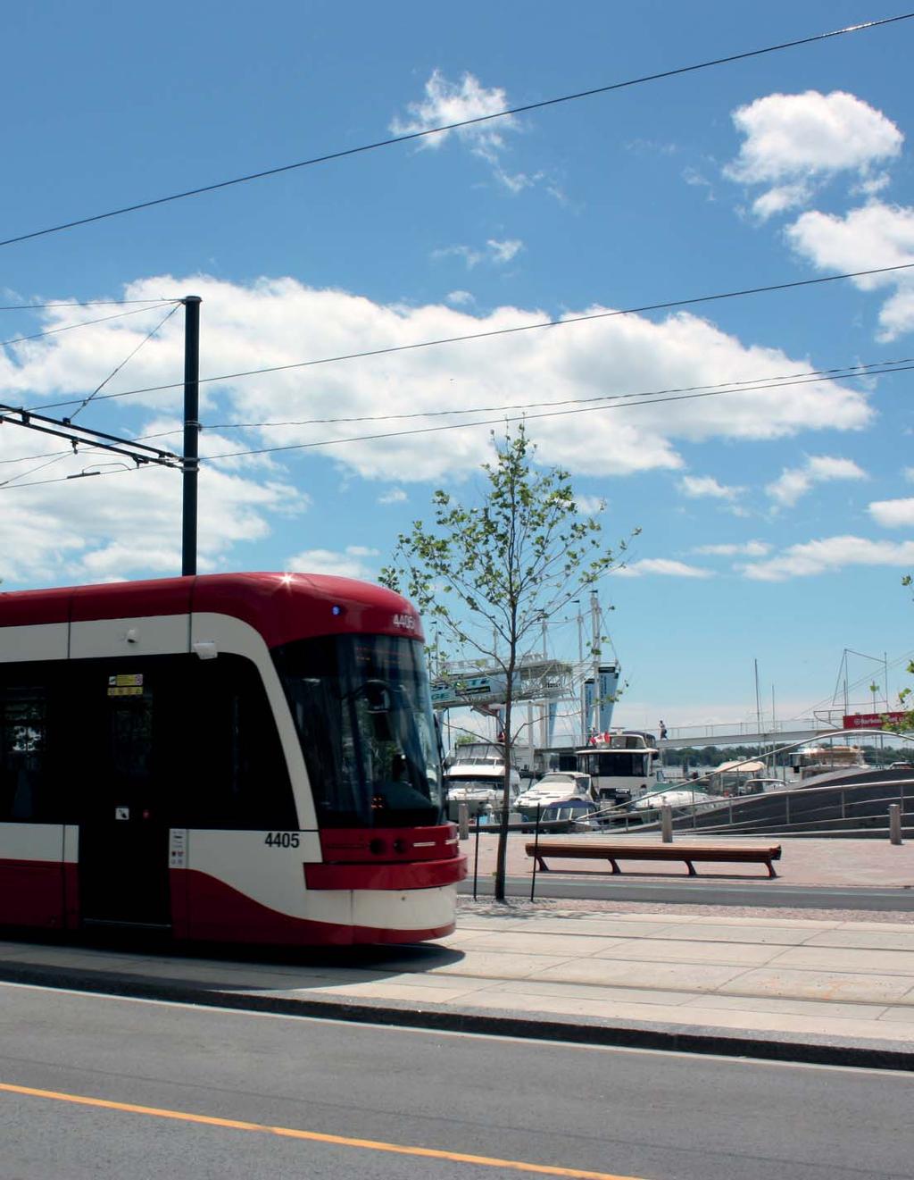
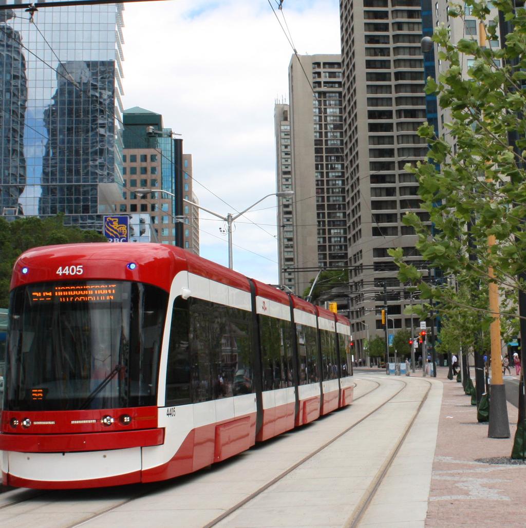
5 Project Information Project Name Project Location Project Size Year Completed June 2015 Entering Firm Arup Role Project Partners Arup Contacts Queens Quay West Revitalization Queens Quay between Bathurst and Parliament Streets, Toronto, Ontario 3.5km of roadway, 1.5km of the Martin Goodman Trail, 9 complex intersections, and 1.5km of utility relocations Engineer providing services for civil, structural, electrical, geotechnical, architecture, landscape, environmental design, traction power design, foundations design, traffic signals, public realm, and construction management. Waterfront Toronto (Owner), West 8 + DTAH in Joint Venture (Landscape Architecture), Eastern Construction (Contractor) Project Manger: Nikos Chalaris nikos.chalaris@arup.com Project Director: Dan Saville dan.saville@arup.com Marketing Contact: Kirsten Warren kirsten.warren@arup.com The Martin Goodman Trail Arup 1

6 Dedicated LRT space within the boulevard Arup 2


7 Project Summary Waterfront Toronto s vision was to transform the congested stretch of Queens Quay into a vibrant public destination in the city. Arup provided planning and multidisciplinary engineering services to transform the 3.5km stretch of busy four lane road into a two-lane, tree-lined, pedestrian and cyclist-friendly waterfront boulevard. It includes 1.5km of light rail; 3.5km of the Martin Goodman Trail; 9 complex intersections; 1.5km of utility relocations - all successfully carried out in a complex stakeholder environment. The Martin Goodman Trail Arup 3


8 Innovation Queens Quay Boulevard West is the centerpiece of Toronto s Central Waterfront. The corridor was reconfigured to connect the Martin Goodman Trail within the city s waterfront, and leverage much-needed rehabilitation of the streetcar tracks. It is now an iconic boulevard and public space to be enjoyed by Torontonians and visitors alike. Working closely with West 8 + DTAH and Waterfront Toronto, Arup reconfigured the transportation plan, redesigned the street and prepared an operational concept to address requirements of the community, businesses, and tourism and transit by incorporating extensive landscape features within existing built environment and within strict site boundaries. During the Environmental Assessment process, the team undertook feasibility studies, conceptual and schematic design and selection of preferred design solutions to address challenging constructability constraint with limited space within the Queens Quay right-of-way. Constructability and feasibility reviews continued during the construction phase in some site specific locations to address unforeseen conditions related to utility conflicts, high water-table levels and conflicting utility relocation schedule constraints. Part of the stakeholder consultation process included using cutting edge simulations in VISSIM to show anticipated traffic and transit flows and to demonstrate how the planned narrowing of Queens Quay would not negatively affect area traffic. Local officials thus gained a comfort level for a plan that promotes sustainability by reducing vehicle traffic and improving public transit. In order to ensure that emergency vehicles can utilize the LRT right-of-way, Arup designed a rolled curb that accommodates emergency vehicle access. Since streetcar platform locations require loading of passengers in the middle of the intersection which required the careful placement of traffic signals and pedestrian push-buttons. The unique configuration of the roadway required careful and detailed planning and design to make sure that traffic, transit, cyclists and pedestrians on the promenade could safely use the intersection together, The design, including the LRT platforms, accommodate boarding access for current LRT vehicles, but can also accommodate future low-floor vehicles. Because plans called for the boulevard to be tree-lined, a detailed analysis of the major and minor flow systems across the corridor was used to identify opportunities for im provements that would promote tree growth. These included introduction of passive irrigation systems to maintain tree health over the long term. Using the space beneath the multi-use trail to increase available soil volume and therefore growing space, and using innovative technology in the form of silva cells resulted in an optimized growing environment. The Martin Goodman Trail Arup 4


9 Overview layout of Queens Quay West - the overall concept kept the streetcar in the same place in the roadway, but completed the Martin Goodman multiuse trail and a generous promenade south of the tracks. Two way traffi c was placed north of the tracks. Waterfront Toronto/West 8 + DTAH Intersection layout - the unique confi guration of Queens Quay required careful and detailed planning to make sure that traffi c, transit, cyclists and pedestrians on the promenade could safely use the intersection together. Waterfront Toronto/West 8 + DTAH 5


10 Complexity The revitalization of Queens Quay Boulevard provided a multitude of complex challenges that needed to be addressed by Waterfront Toronto and the design team. The 3.5km stretch of road that was redeveloped sits at the heart of downtown Toronto and is used as a key thoroughfare for east-west traffic along the city s waterfront. It is lined by a large number of commercial, residential, and industrial users, and includes elements that are under the jurisdiction of the City of Toronto, the TTC, and utility companies. In addition, soil conditions are challenging due to infill and a high water table. Part of the stakeholder consultation process included using cutting edge simulations in VISSIM to show anticipated traffic and transit flows and to demonstrate how the planned narrowing of Queens Quay would not negatively affect area traffic. Local officials and other project stakeholders thus gained a comfort level for a plan that promotes sustainability by reducing vehicle traffic and improving public transit. Another key challenge was utility relocations. The existing right-of-way was developed in an ad-hoc fashion, with each utility company laying infrastructure in any available space (water, sanitary and storm mains, power ducts, telecommunications cables, and gas mains.) The design team developed complicated staging plans to allow utilities to be consolidated within a single trench, and, where possible, to be stacked. The engineering efforts and extensive stakeholder consultations resulted in a successful project that has transformed the community. The new Queens Quay Boulevard Arup 6


11 Social and/or Economic Benefits The revitalization of Toronto s waterfront is proving to be an economic driver. ~ Finance Minister, Joe Oliver The newly transformed Queens Quay has the potential to substantially contribute to the economic and social quality of life for the citizens of Toronto. The central waterfront area is now a destination for locals and visitors alike, providing a variety of experiences and amenities. Traffic flow was improved in many respects. Transit and traffic now move together through intersections improving efficiency, whereas before they moved separately. Dedicated parking lay-bys were provided for the many businesses on the north side of the street. With the city to the north, having traffic north of the tracks improves flow for turning movements. People can experience the waterfront in a variety of ways - by foot along the granite walkway, by bike, by transit and still by car to the various major parking facilities for which access had to be maintained. Businesses and condominiums on the north side of the street now front onto widened sidewalks with granite sidewalks and a row of mature trees, and provide opportunities for shopping, dining, and a large array of recreational activities. It provides the kind of atmosphere conducive to economic vitality, ground floor retail activity and urban vibrancy. With the high number of tourists who visit the waterfront for events at Harbourfront Centre, cruises and other recreation, the revitalization also included a comprehensive bus management strategy for large groups arriving via coach and bus. Queens Quay West has become an iconic street that is as beautiful as it is functional. Birds Eye View of Queens Quay Boulevard looking east Waterfront Toronto/West 8 + DTAH 7


12 Environmental Benefits The quality of environmental design is evident in the boulevard s trees which are each given adequate growing space using innovative technology in the form of silva cells and providing significant environmental benefits, on-site stormwater management, improved soil and water quality and reduced erosion. Several cross sections were considered to find the optimum configuration and placement of various utilities and tree soil structures in the constrained rightof-way. To maintain healthy trees, several details were considered including irrigation and using space beneath the multi-use trail to increase available soil volume. Arup also coordinated the permits and approvals associated with the Ministry of the Environment, City of Toronto, TTC and utilities. To ensure the continued operations of the LRT system throughout winter, and potential heavy snowfalls, the design team carefully considered both the longitudinal profile and transverse section to ensure adequate positive drainage was provided to prevent flooding during thaws (when road and tracks are salted throughout the winter, and in the spring). Inherent in the project is a mode shift on the street away from cars toward pedestrians, cyclists and transit users. By updating the transit signal priority and bike signals, the newly redesigned street makes alternative modes of transportation more comfortable, reducing the number of cars. Additionally, in the simulations, improved traffic flows resulted in less delay and therefore reduced vehicle emissions. Tree planting and drainage options Arup 8
 Waterfront Toronto President and CEO The key objective of the Queen s Quay West revitalization project was to transform the city s main waterfront thoroughfare into a modern,")
13 Meeting Client s Needs This has been an intensive nine-year project and Arup has been a creative partner in creating this new street typology. ~ John Campbell (Former) Waterfront Toronto President and CEO The key objective of the Queen s Quay West revitalization project was to transform the city s main waterfront thoroughfare into a modern, complete street and public promenade. Waterfront Toronto recognized the need to have Queens Quay act as the spine of the central waterfront. The revitalized street now has an iconic design fit for Toronto s main waterfront street. The project re-organized the layout of the entire street, separating cyclists and pedestrians from cars and thereby also improving safety. With outstanding results, the team managed to create an destination that integrates the overall waterfront park and trail system offering both active and passive users diverse experiences and memories. The project offers an outdoor space for public gathering that can host compelling activities, community events, entertainment, and cultural activities to draw a range of audiences throughout the different seasons. It also provides a public backyard for all Ontarians one that enhances the natural setting and one that provides yearround and barrier-free access to outdoor public space. After three years of construction, Queens Quay West opened to the public in June 2015, on schedule and in time for both the Pan Am Games and the Redpath Waterfront Festival. Quay to the City Pilot Project Waterfront Toronto/West 8 + DTAH 9


14 before Waterfront Toronto/West 8 + DTAH after West 8 + DTAH 10
15 Arup
There is Complexity in Beauty; Engineering Toronto s New Waterfront Boulevard Marc-Paul Gauthier, Senior Technologist, Arup Paper prepared for
 There is Complexity in Beauty; Engineering Toronto s New Waterfront Boulevard Marc-Paul Gauthier, Senior Technologist, Arup Paper prepared for presentation at the Geometric Design Lessons Learned session
Welcome. Community Consultation Meeting November 28, Review and discuss the Bathurst Quay Neighbourhood Plan Framework
 Welcome Community Consultation Meeting November 28, 2016 Why Are We Here Today? Review and discuss the Bathurst Quay Neighbourhood Plan Framework Review and discuss an Action Plan for Implementation Next
St. Clair Avenue West Area Transportation Master Plan
 1 (Between Keele Street and Old Weston Road) Public Information Centre 1 December 2, 2015 2 Welcome Welcome to the first Public Information Centre for the St. Clair Avenue West Area. The panels will present
Public Open House. Overview of the Downtown Plan Official Plan Amendment April 23, 2018
 Public Open House Overview of the Downtown Plan Official Plan Amendment April 23, 2018 1 A 25-Year Plan for Downtown To ensure growth contributes positively to Toronto s Downtown as a great place to live,
Bloor Street East Potential Ravine Portal Overlook and Access Passage to the Rosedale Valley and Don River Valley Ravine, Toronto, Canada
 TRANSFORMATIVE IDEA 2. GREAT STREETS Bloor Street Christie Pits Park Bloor St Spadina Ave Bathurst St Shaw St 1 Recognize the significant public realm improvements along Bloor Street and extend and enhance
Purpose of Open House #3
 Public Meeting #3 May 9, 2009 MVVA Team Purpose of Open House #3 The main purpose of this Open House is to present and seek input on the: Evaluation of transportation and infrastructure design alternatives
Public Meeting #3 May 9, 2009 MVVA Team
 Public Meeting #3 May 9, 2009 MVVA Team Welcome to the third Public Meeting for the Lower Don Lands Municipal Class Environmental Assessment (EA) Infrastructure Master Plan and Keating Channel Precinct
Chairman and Members of the Planning and Development Committee. Thomas S. Mokrzycki, Commissioner of Planning and Building
 LA.09.TOR (Toronto) DATE: TO: FROM: SUBJECT: Chairman and Members of the Planning and Development Committee Thomas S. Mokrzycki, Commissioner of Planning and Building Central Waterfront Secondary Plan
Lambeth Main Street Streetscape Improvements
 Lambeth Main Street Streetscape Improvements Open House October 5th, 2017 Agenda 1. Introduction 2. Project Background 3. Context 4. Project Objectives 5. Design Principles & Approach 6. Streetscape Design
LUNDY S LANE COMMUNITY IMPROVEMENT PLAN STUDY
 PUBLIC INFORMATION MEETING #2 October 12, 2016 LUNDY S LANE COMMUNITY IMPROVEMENT PLAN STUDY AGENDA 5:00 to 5:30pm: Open House 5:30 to 6:15pm: Presentation 6:15 to 7:00pm: Individual paced workshop with
PROPOSED REDEVELOPMENT OF THE GLEN ABBEY GOLF CLUB. STREETSCAPE DESIGN STUDY (excerpt from the Urban Design Brief) TOWN OF OAKVILLE.
 TOWN OF OAKVILLE.") PROPOSED REDEVELOPMENT OF THE GLEN ABBEY GOLF CLUB STREETSCAPE DESIGN STUDY (excerpt from the Urban Design Brief) TOWN OF OAKVILLE OCTOBER, 2016 for 2.4.2 STREETS Streets are the single largest component
PROPOSED REDEVELOPMENT OF THE GLEN ABBEY GOLF CLUB STREETSCAPE DESIGN STUDY (excerpt from the Urban Design Brief) TOWN OF OAKVILLE OCTOBER, 2016 for 2.4.2 STREETS Streets are the single largest component
Urban Design Manual PLANNING AROUND RAPID TRANSIT STATIONS (PARTS) Introduction. Station Study Areas
 Introduction. Station Study Areas") 111111 PLANNING AROUND RAPID TRANSIT STATIONS (PARTS) Introduction The ION rapid transit system will link Waterloo, Kitchener and Cambridge through a central transit corridor (CTC). There are a number
111111 PLANNING AROUND RAPID TRANSIT STATIONS (PARTS) Introduction The ION rapid transit system will link Waterloo, Kitchener and Cambridge through a central transit corridor (CTC). There are a number
Don Mills Crossing Study and Celestica Lands Development Application Community Meeting, Open House, and Breakout Discussions
 Consultation Summary Don Mills Crossing Study and Celestica Lands Development Application Community Meeting, Open House, and Breakout Discussions This report is not intended to provide a verbatim transcript
Toronto Complete Streets Guidelines
 Toronto Complete Streets Guidelines 108 110 7.1 Green Infrastructure Design Principles 112 7.2 Context-Sensitive Green Streets 114 7.3 Key Green Street Elements Green infrastructure refers to natural and
Transportation Master Plan Environmental Assessment
 Transportation Master Plan Environmental Assessment AUGUST, 2014 Waterfront Toronto / Perkins + Will Lower Yonge Transportation Master Plan Environmental Assessment Contents Executive Summary 1 1 Introduction
Toronto Complete Streets Guidelines
 c. DTAH 58 60 3.1 70 3.2 Performance Measurement 71 3.3 Exceptions Chapter 3 describes the five general steps in the street design process. Not all projects follow these steps, as the number of steps and
QUEENS QUAY REVITALIZATION ENVIRONMENTAL ASSESSMENT
 Appendix 1 Muncipal Class Environmental Study Report Executive Summary QUEENS QUAY REVITALIZATION ENVIRONMENTAL ASSESSMENT Waterfront Toronto and the City of Toronto May 2009 Appendix 1 Waterfront Toronto
Ivywild On The Creek PRELIMINARY CREEK DISTRICT MASTER PLAN
 Ivywild On The Creek PRELIMINARY CREEK DISTRICT MASTER PLAN Introduction: Rejuvenating an extraordinary Creekside neighborhood THE CREEKSIDE DISTRICT The Ivywild On The Creek Neighborhood District Master
4- PA - LD - LIVELY DOWNTOWN. LD - Background
 4- PA - LD - LIVELY DOWNTOWN LD - Background The downtown has been the service centre for the community since the city s inception and the area continues to supply people with their personal services,
PLAN ELEMENTS WORKSHOP. April 5, 2016
 PLAN ELEMENTS WORKSHOP April 5, 2016 needs more housing. But there is no one-size fits-all solution. Every neighborhood has its own character. In some places, density is not only appropriate it is badly
Welcome. Walk Around. Talk to Us. Write Down Your Comments
 Welcome This is an information meeting introducing the applications for proposed redevelopment of the Yorkdale Shopping Centre site at 3401 Dufferin Street and 1 Yorkdale Road over the next 20+ years,
URBAN DESIGN BRIEF. 2136&2148 Trafalgar Road. Town of Oakville
 URBAN DESIGN BRIEF 2136&2148 Trafalgar Road Town of Oakville Prepared By: METROPOLITAN CONSULTING INC For 2500674 Ontario Inc November 2016 TABLE OF CONTENTS Page No. 1.0 Introduction/Description of Subject
This Review Is Divided Into Two Phases:
 Semiahmoo Town Centre Review The purpose of this review: To review the Semiahmoo Town Centre Concept Plan, originally approved in 1993, to ensure that this centre will continue to serve the needs of South
Figure 3-1: Public Realm Plan
 3 Public Realm Figure 3-1: Public Realm Plan 3.1 Public Realm Concept The public realm concept for the Little Mountain site integrates a clear and accessible movement network with public spaces for social
John M. Fleming Managing Director, Planning and City Planner. Old East Village Dundas Street Corridor Secondary Plan Draft Terms of Reference
 Report to Planning and Environment Committee To: From: Subject: Chair and Members Planning & Environment Committee John M. Fleming Managing Director, Planning and City Planner Old East Village Dundas Street
PLANNING ADVISORY BOARD AGENDA OCTOBER
 ! City of Langley PLANNING ADVISORY BOARD AGENDA OCTOBER 1, 2014 3-5pm LANGLEY CITY HALL - 112 2 nd Street, Langley WA 1) Call to Order and Roll Call 2) Approval of the Minutes September 10, 2014 3) Public
TEMPLE MEDICAL & EDUCATION DISTRICT
 City of Temple, Texas TEMPLE MEDICAL & EDUCATION DISTRICT 1 Description. The City of Temple joined in partnership with key public and private entities to jointly promote education and medical activities
City of Farmington. Downtown Plan. Amendment to the 1998 Master Plan Adopted October 11, 2004
 City of Farmington Amendment to the 1998 Master Plan Adopted October 11, 2004 Introduction Planning Background 1 Scope and Components of the Plan Amendment 2 Concept Introduction 3 Plan Concepts 3 Conceptual
Director, Community Planning, Toronto and East York District
 Lower Yonge Precinct Plan Update STAFF REPORT ACTION REQUIRED Date: October 16, 2012 To: From: Wards: Reference Number: Toronto and East York Community Council Director, Community Planning, Toronto and
Ashbridges Bay TTC Maintenance and Storage Facility
 Ashbridges Bay TTC Maintenance and Storage Facility September 8, 2010 Presented to Government Review Team 1 Presentation Overview Overview of the Project Status of Transit Project Assessment Process Potential
Animating the Rideau Canal December 2013
 Executive Summary Animating the Rideau Canal December 2013 Why study the Rideau Canal? The Rideau Canal has been an important part of Ottawa throughout its history, and has shaped and been shaped by the
SAN RAFAEL GENERAL PLAN 2040 INTRODUCTION AND OVERVIEW
 SAN RAFAEL GENERAL PLAN 2040 INTRODUCTION AND OVERVIEW Steering Committee Presentation February 14, 2018 Purpose of General Plan Guide land use and development decisions Coordinate transportation, infrastructure,
Toronto Waterfront Revitalization
 Toronto Waterfront Revitalization Toronto Waterfront Revitalization Corp. Established 2001 Tripartite - Government of Canada, Province of Ontario, City of Toronto Master developer, comprehensive integrated
Keyport. Vision for Keyport
 Keyport Vision for Keyport Keyport is a rural, historic waterfront village bounded and limited in size by its natural borders of water and the Naval Undersea Warfare Center. The community consists primarily
38 Queen s University Campus Master Plan Part 1
 38 Queen s University Campus Master Plan Part 1 46 The Campus at the City Scale Chapter 4 The Campus at the City Scale 39 Queen s is an urban University centrally located in Kingston. Decisions made by
The transportation system in a community is an
 7 TRANSPORTATION The transportation system in a community is an important factor contributing to the quality of life of the residents. Without a sound transportation system to bring both goods and patrons
The Master Plan Framework
 The Master Plan Framework The East Harbour Master Plan advances the development of 60 acres of former industrial lands east of the Don River. The Master Plan outlines a vision for a vibrant, transit-oriented
Port Credit Local Advisory Panel October 20 th Meeting
 Port Credit Local Advisory Panel October 20 th Meeting Focus Of This Evening s Meeting: 1. Hurontario Main Street Higher Order Transit Study 2. Port Credit Mobility Hub & GO Station Parking Structure Study
Visioning Statement and Guiding Principles
 Visioning Statement and Guiding Principles Planning for the Future The General Plan The General Plan represents Woodland's shared vision of the future and defines a path to lead the community toward its
Olde Towne Vision Plan
 Olde Towne Vision Plan Introduction In 2016, the City of Bellevue will complete its move of City offices from Olde Towne Bellevue to its new municipal complex on Wall Street. The City intends to sell its
Public input has been an important part of the plan development process.
 Lakewood s Comprehensive Plan recognizes that transportation helps shape the community, and that the way the community provides for the safe and efficient movement of people affects the character of the
Scope of Services. River Oaks Boulevard (SH 183) Corridor Master Plan
 Corridor Master Plan") Scope of Services River Oaks Boulevard (SH 183) Corridor Master Plan PROJECT AREA The project area consists of the River Oaks Boulevard (SH 183) corridor bounded by SH 199 at the northern end and the Trinity
Scope of Services River Oaks Boulevard (SH 183) Corridor Master Plan PROJECT AREA The project area consists of the River Oaks Boulevard (SH 183) corridor bounded by SH 199 at the northern end and the Trinity
[PLANNING RATIONALE] For Site Plan Control and Lifting of Holding Zone By-Law 101 Champagne Avenue. May 23, 2014
![[PLANNING RATIONALE] For Site Plan Control and Lifting of Holding Zone By-Law 101 Champagne Avenue. May 23, 2014](/thumbs/75/71599615.jpg "[PLANNING RATIONALE] For Site Plan Control and Lifting of Holding Zone By-Law 101 Champagne Avenue. May 23, 2014") [PLANNING RATIONALE] For Site Plan Control and Lifting of Holding Zone By-Law 101 Champagne Avenue May 23, 2014 Contents 1.0 Introduction... 2 2.0 Site Context... 2 2.1 Adjacent Uses... 2 Figure 1: Site
[PLANNING RATIONALE] For Site Plan Control and Lifting of Holding Zone By-Law 101 Champagne Avenue May 23, 2014 Contents 1.0 Introduction... 2 2.0 Site Context... 2 2.1 Adjacent Uses... 2 Figure 1: Site
CITY OF CHARLOTTESVILLE, VIRGINIA CITY COUNCIL AGENDA
 CITY OF CHARLOTTESVILLE, VIRGINIA CITY COUNCIL AGENDA Agenda Date: December 16, 2013 Action Required: Adoption of Resolution Presenter: Staff Contacts: Title: James E. Tolbert, AICP, Director of NDS James
Midtown Greenway Land Use and Development Plan Executive Summary
 Midtown Greenway Land Use and Development Plan Executive Summary Introduction The Midtown Greenway Land Use and Development Plan sets policy direction for land use and development in the Midtown Greenway
The Vision. Photo provided by The Minervini Group. 46 Vision, Objectives & Strategies
 Vision, Objectives & Strategies The is the public framework and guide for future development of the Grand Traverse Commons. The establishes public polices for infrastructure, the preservation of natural
CHAPTER 7: Transportation, Mobility and Circulation
 AGLE AREA COMMUNITY Plan CHAPTER 7 CHAPTER 7: Transportation, Mobility and Circulation Transportation, Mobility and Circulation The purpose of the Transportation, Mobility and Circulation Chapter is to
Downtown North Las Vegas Demonstration Site Project. Project Update
 Downtown North Las Vegas Demonstration Site Project Project Update 7.16.14 Presentation Overview Project Purpose and Process Planning Context Opportunities and Barriers Summary Community Input Preliminary
Potential Green Infrastructure Strategies May 6, 2015 Workshop
 Potential Green Infrastructure Strategies May 6, 2015 Workshop Background The City of Cortland is developing the Tioughnioga Urban Headwaters Green Infrastructure Action Plan with funding from the National
Principal development issues
 Principal development issues The transformation of the Bonaventure Expressway from Saint- Jacques to Brennan Streets will create a major urban boulevard with lanes located on either side of a string of
c. DTAH Toronto Complete Streets Guidelines
 c. DTAH Toronto Complete Streets Guidelines 164 166 C.1 Project Delivery Process 168 C.5 This section provides a summary of the overarching process for delivering street projects in Toronto. The conclusion
Streets for People, Place-Making and Prosperity. #TOcompletestreets
 COMPLETE STREETS FOR TORONTO Streets for People, Place-Making and Prosperity COMPLETE STREETS: A NEW APPROACH A Complete Streets design approach considers the needs of all users people who walk, bicycle,
planning toronto s downtown Parks and Public Realm Plan Request for Proposals Information Meeting Andrew Farncombe, Project Manager August 19, 2015
 planning toronto s downtown Parks and Public Realm Plan Request for Proposals Information Meeting Andrew Farncombe, Project Manager August 19, 2015 BATHURST ST Keeping Downtown a great place to live, work,
SQUAMISH 2010 AND BEYOND COMMUNITY VISION
 Our plan has been imagined and created to be both pragmatic and visionary. At the core of the strategy is a consideration of the highway s role and its impact on the community. First and foremost in creating
GUIDELINES EXHIBITION PLACE LOCATION: OBJECTIVES. Structure Plan URBAN DESIGN GUIDELINES
 Development in the Exhibition Place lands will be consistent with the following urban design guidelines. They provide a framework for new development of the lands and are to be read in conjunction with
URBAN DESIGN BRIEF URBAN DESIGN BRIEF 721 FRANKLIN BLVD, CAMBRIDGE August 2018
 URBAN DESIGN BRIEF URBAN DESIGN BRIEF 721 FRANKLIN BLVD, CAMBRIDGE August 2018 DESIGN BRIEF CONTENTS PART A 1.0 INTRODUCTION 2.0 DESCRIPTION & ANALYSIS OF SITE CONTEXT 3.0 DESIGN CONSTRAINTS AND OPPORTUNITIES
City of Long Beach. creating vibrant and exciting places
 City of Long Beach creating vibrant and exciting places Land Use Element Urban Design Element Overview of the two draft General Plan elements Discuss areas of change Economic goals of the plans Case study
4.1.3 LAND USE CATEGORIES
 4.1.3 LAND USE CATEGORIES a. City Center District The City Center District incorporates the existing character and mix of uses in downtown Belmont to encourage redevelopment and new development in keeping
Stakeholders Advisory Working Groups (SAWGs) Smart Growth and TOD Land Use (#11) SAWG Meeting
 Smart Growth and TOD Land Use (#11) SAWG Meeting") Presentation - Part II Tappan Zee Bridge/I-287 Corridor Project July 21, 2010 Slide 1. David Kooris (Regional Plan Association) welcomed members of the Land Use Stakeholders Advisory Working Groups (SAWGs)
Presentation - Part II Tappan Zee Bridge/I-287 Corridor Project July 21, 2010 Slide 1. David Kooris (Regional Plan Association) welcomed members of the Land Use Stakeholders Advisory Working Groups (SAWGs)
Johnson Street Bridge Public Realm Update
 Johnson Street Bridge Public Realm Update August 20, 2015 Background Johnson Street Bridge Replacement Project impacts a diverse range of stakeholders In addition to a new bridge, the project also includes
Redevelopment of Ajax Plaza Area Public Open House Meeting February 19, 2015 Questions and Answers
 Redevelopment of Ajax Plaza Area Public Open House Meeting February 19, 2015 Questions and Answers Redevelopment of Ajax Plaza Area Why is the redevelopment of the Ajax Plaza important to the revitalization
SUMMERSIDE / MT. CARMEL REINVESTMENT CORRIDOR COMMUNITY DEVELOPMENT STRATEGY
 SUMMERSIDE / MT. CARMEL REINVESTMENT CORRIDOR COMMUNITY DEVELOPMENT STRATEGY FEBRUARY 2013 I. Location of the Summerside/Mt. Carmel Reinvestment Corridor The Summerside/Mt. Carmel Reinvestment Corridor
Promoting Economic Development Through Upfront SEPA Review: Lessons from South Downtown Tacoma
 Promoting Economic Development Through Upfront SEPA Review: Lessons from South Downtown Tacoma 1 This session will focus on the City of Tacoma s South Downtown Subarea Plan and associated Non-Project SEPA
Queensborough Eastern Neighbourhood Node. Community Open House
 Queensborough Eastern Community Open House The Vision The Queensborough Eastern will become the heart of eastern Queensborough. Through a sensitive mix of viable commercial and residential areas, the neighbourhood
A BLUEPRINT FOR BROCKTON A CITY-WIDE COMPREHENSIVE PLAN
 A BLUEPRINT FOR BROCKTON A CITY-WIDE COMPREHENSIVE PLAN Public Meeting October 2016 1 Plan Summary and Discussion Public Meeting May 4 2017 City of Brockton Bill Carpenter, Mayor Department of Planning
Town Center (part of the Comprehensive Plan)
") Town Center (part of the Comprehensive Plan) Mercer Island Town Center Looking North (2014) In 1994, a year-long process culminated in a set of design guidelines and code requirements for the Town Center
Town Center (part of the Comprehensive Plan) Mercer Island Town Center Looking North (2014) In 1994, a year-long process culminated in a set of design guidelines and code requirements for the Town Center
9 North Downtown Master Plan & Saskatchewan Polytechnic
 9 North Downtown Master Plan & Saskatchewan Polytechnic Overview The area south of 33 rd Street (across from Kelsey-Woodlawn) will begin to see significant changes in the future. The North Downtown Master
EXISTING COMPREHENSIVE PLAN
 EXISTING COMPREHENSIVE PLAN Town Center Land Use Element: V. LAND USE POLICIES Town Center Mercer Island's business district vision as described in "Your Mercer Island Citizen-Designed Downtown" was an
QUEEN-RIVER SECONDARY PLAN
 34 QUEEN-RIVER SECONDARY PLAN 34. QUEEN RIVER SECONDARY PLAN 1. INTRODUCTION The Queen-River area is approximately 6.4 hectares and is located at the eastern edge of the Downtown as shown on Map 34-1.
Green Line North Centre City Alignment
 Project overview The Green Line will be an important piece of Calgary's transit network, adding 40 kilometres of track to the existing 59 kilometre LRT system. End-to-end, the line will connect North Pointe
Developer s Program. The Station at East 54
 Developer s Program The Station at East 54 Existing Conditions The Station at East 54 is proposed for a 1.12 acre site at the northeast corner of Hamilton Road and Prestwick Road, tucked between the East
PORT WHITBY COMMUNITY
 PORT WHITBY COMMUNITY SECONDARY PLAN UPDATE COMMUNITY IMPROVEMENT PLAN URBAN DESIGN GUIDELINES September 2015 DRAFT PROPOSED AMENDMENT NUMBER # to the Whitby Official Plan PURPOSE: The intent of this Amendment
Silverdale Regional Center
 Silverdale Regional Center Vision for Silverdale Regional Center The Silverdale Regional Center Plan (Plan) will guide the evolution of the Silverdale Regional Center from a collection of strip malls and
Relief Line Project Assessment
 Relief Line Project Assessment Public Information Centre April 5, 2017 Tonight s Meeting PURPOSE To review the preferred alignment for the Local Segment. AGENDA 6:30 Open House 7:00 Presentation / Discussion
UTSC SECONDARY PLAN COMMUNITY OPEN HOUSE
 WELCOME TO THE UTSC SECONDARY PLAN COMMUNITY OPEN HOUSE 1 Welcome to the first Community Open House for the UTSC Secondary Plan. Hosted by the University of Toronto Scarborough (UTSC), the following panels
CHAPTER 5: GUIDING PRINCIPLES
 CHAPTER 5: GUIDING PRINCIPLES The following 10 principles were developed based on public consultation, planning policy and the background analysis conducted during Phase 1. The Guiding Principles significantly
BATHURST QUAY NEIGHBOURHOOD PLAN IMPLEMENTATION. Streetscape & Public Realm Improvement Plan - Canada Malting Silo Site and Eireann Quay
 BATHURST QUAY NEIGHBOURHOOD PLAN IMPLEMENTATION Streetscape & Public Realm Improvement Plan - Canada Malting Silo Site and Eireann Quay Bryan Bowen, Waterfront Secretariat November 25, 2017 Presentation
Active Neighbourhoods Canada SUMMARY REPORT
 Prepared by the Toronto Centre for Active Transportation JUNE 2017 Active Neighbourhoods Canada SUMMARY REPORT OF 4 ONTARIO PROJECTS Sharing participatory methods in Ontario Active Neighbourhoods Canada
Urban Planning and Land Use
 Urban Planning and Land Use 701 North 7 th Street, Room 423 Phone: (913) 573-5750 Kansas City, Kansas 66101 Fax: (913) 573-5796 Email: planninginfo@wycokck.org www.wycokck.org/planning To: From: City Planning
TOWN BRANCH COMMONS & VINE STREET MOBILITY IMPROVEMENTS
 TOWN BRANCH COMMONS & VINE STREET MOBILITY IMPROVEMENTS CONTACT: Jeff Fugate, President O: 859-367-4972 F: 859-425-2292 JFugate@LexingtonDDA.com www.lexingtondda.com TOWN BRANCH COMMONS & VINE STREET MOBILITY
Shift Rapid Transit Public Participation Meeting May 3, 2017
 Shift Rapid Transit Public Participation Meeting May 3, 2017 Shift Rapid Transit Initiative Largest infrastructure project in the city s history. Rapid Transit initiative will transform London s public
Chapter 4. Linking Land Use with Transportation. Chapter 4
 Chapter 4 Linking Land Use with Transportation Chapter 4 59 Chapter 4 Linking Land Use with Transportation Community Design and Transportation Program Introduction Since the 1950s, the predominant development
Urban Land Institute Toronto / January John Street Revitalization. Public Realm Improvement Plan
 Urban Land Institute Toronto / January 2013 John Street Revitalization Public Realm Improvement Plan Contents Introduction... 1 Process... 2 Existing Conditions... 4 Analysis > Synthesis... 6 Design Principles...
Hockessin Community Redevelopment Plan
 Hockessin Community Redevelopment Plan 3.1 Introduction The Community Redevelopment Plan for the Village of Hockessin is the result of the people s vision for a distinct village center that serves as the
Transportation. Strategies for Action
 Transportation A major priority for the Overlake Neighborhood is to develop a multimodal transportation system. To achieve this system, a balance has to be found among travel, circulation and access needs;
OFFICE CONSOLIDATION SECONDARY PLAN AREA 22 THE BRAMALEA SOUTH INDUSTRIAL SECONDARY PLAN
 OFFICE CONSOLIDATION SECONDARY PLAN AREA 22 THE BRAMALEA SOUTH INDUSTRIAL SECONDARY PLAN November 2010 EXPLANATORY NOTES (Secondary Plan Area 22) General (pertaining to all secondary plan office consolidations)
7Page 91 CLEMMONS COMMUNITY COMPASS 7 COMMUNITY CHARACTER
 7 Community Character The beauty of Clemmons won t necessarily be a reflection of our past, but our future. This quote from Comprehensive Plan Steering Committee member Wayne Dodson captures the essence
WELCOME TO OPEN HOUSE # 3
 Bayview Avenue Class Environmental Assessment Study Steeles Avenue to Elgin Mills Road WELCOME TO OPEN HOUSE # 3 Please sign in and join our mailing list Why Are We Here Tonight? Study Process and Purpose
IMAGINE CLEARWATER. Community Workshop 3. November 2016
 IMAGINE CLEARWATER Community Workshop 3 November 2016 Imagine Clearwater has been a 6-month community-focused process to re-envision the downtown waterfront. VISIONING FRAMEWORK MASTER PLAN HOW CAN WE
Complete Neighbourhood Guidelines Review Tool
 Complete Neighbourhood Guidelines Review Tool Prepared By: City of Regina Planning Department October 2014 Page 1 of 14 Community Development Review Checklist for Secondary Plans and Concept Plans The
Downtown Streetscape Manual & Built Form Standards
 City of Guelph Downtown Streetscape Manual & Built Form Standards July 2014 Prepared by Brook McIlroy Inc. in association with Unterman McPhail Associates and McCormick Rankin Inc. City of Guelph Downtown
ARISE: The Rock Renaissance Area Redevelopment & Implementation Strategy
 2014 Professional Awards 1 ARISE: The Rock Renaissance Area Redevelopment & Implementation Strategy Janesville, WI Completed December 2014 Analysis & Planning Purpose of Project 2 The purpose of the Rock
Plano Tomorrow Vision and Policies
 Plano Tomorrow Vision and Policies PLANO TOMORROW PILLARS The Built Environment The Social Environment The Natural Environment The Economic Environment Land Use and Urban Design Transportation Housing
T H A T E V E R Y O N E
 B R I N G I N G C H A N G E T H A T E V E R Y O N E C A N F E E L. AT CHW, we survey, plan, design, engineer, administer and inspect with a purpose: to positively transform the communities we serve. From
In surveys, Dallas residents say what they want to change most
 NEIGHBORHOODS ELEMENT In surveys, Dallas residents say what they want to change most in the city is its appearance they want it to look beautiful, with trees and pedestrian-friendly neighborhoods. The
hermitage town center
 hermitage town center A Community Vision prepared by Strada for The City of Hermitage and The Mercer County Regional Planning Commission January 2007 table of contents introduction 3 design principles
Adelaide Street / Canadian Pacific Railway (CPR) Grade Separation Class Environmental Assessment. Public Information Centre 3
 Grade Separation Class Environmental Assessment. Public Information Centre 3") 1 Adelaide Street / Canadian Pacific Railway (CPR) Grade Separation Study Process and Purpose of PIC 3 2 Study Commencement February 2016 Phase 1: Problem and Opportunity Identify problems and opportunities
1 Adelaide Street / Canadian Pacific Railway (CPR) Grade Separation Study Process and Purpose of PIC 3 2 Study Commencement February 2016 Phase 1: Problem and Opportunity Identify problems and opportunities
ELK GROVE GENERAL PLAN VISION
 2-1 CHAPTER 2: 2-2 CREATING OUR The Community Vision for Elk Grove, expressed through a Vision Statement and a series of Supporting Principles, is a declaration of the kind of community that Elk Grove
Key Themes and Responses May 2016
 King and Victoria Transit Hub and Waterloo Street Pedestrian Access Key Themes and Responses May 2016 The following summarizes what Regional staff heard about the King Victoria Transit Hub and Waterloo
A. Background Summary of Existing Challenges and Potential Possibilities. 1. Summary of Existing Assets and Potential Opportunities
 A. Background 1 A Main Street Master Plan Study was performed and completed in October of 2007. The study was initiated to review current land uses and development patterns along Main Street, from Parrish