John Portman Boulevard Corridor
|
|
|
- Caitlin McDonald
- 5 years ago
- Views:
Transcription


1 Corridor Multi-use Path + Streetscape Improvements February 8, 13

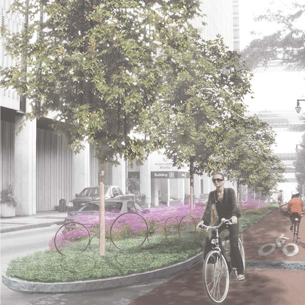
2 SOUTH SIDE BLOCK IMPROVEMENT NOTES: Consolidation of Utility/Sign Locations Remove Existing Trees Centennial Olympic Park Drive Planter Driveway/ Cobble Pavers American Cancer Society Multi-Use Trail Left Turn/ Taxi Queuing Williams Street Driveway Note: Driveway narrowed to allow additional planter N 4 8 Proposed Plan: Block 1
 AmericasMart Bldg N 4 8 Proposed Plan:")
3 AmericasMart Bldg 3 Planter (Overhead) Multi-Use Trail Driveway/ Cobble Pavers Spring Street Williams Street SOUTH SIDE BLOCK IMPROVEMENT NOTES: Remove Existing Trees and Grates Driveway (Overhead) AmericasMart Bldg N 4 8 Proposed Plan: Block
 Existing Utilities in (to remain) Driveway")
4 SOUTH SIDE BLOCK IMPROVEMENT NOTES: Existing Grate/Vault Structures to remain Spring Street Turning Movements from Northbound traffic from Spring St. require mountable curb and setback/cobble Pavers * Capital City Club Planter Peachtree Street Driveway/ Cobble Pavers Multi-Use Trail (Overhead) Existing Utilities in (to remain) Driveway AmericasMart Bldg 1 AmericasMart Bldg. 1 Entry Awning * N 4 8 *Note: Installing trees in these locations may not be possible due to building face, sub-surface, and/or spatial and pedestrian safety and mobility constraints. The potential for tree installation will be confirmed during detail design. Proposed Plan: Block 3

5 Turning Movements from Peachtree St. require mountable curb and setback/cobble Pavers Hyatt Regency Planter Multi-Use Trail Left Turn/ Taxi Queuing Peachtree Center Avenue Peachtree Street SOUTH SIDE BLOCK IMPROVEMENT NOTES: Remove Existing Trees and Grates 41 Peachtree St. Bldg. Entrance Driveway Peachtree Center N Sun Trust 4 8 Proposed Plan: Block 4

6 SOUTH SIDE BLOCK IMPROVEMENT NOTES: Consolidation of Utility/Sign Locations Wood Power Poles/Overhead Utilities Removed Remove Existing Trees and Grates (5) Existing Curb Cuts Removed Peachtree Center Avenue Turning Movements from Peachtree Center Ave. require mountable curb and setback/cobble Pavers * Planter Marriott Marquis Driveway/ Cobble Pavers Multi-Use Trail (Overhead) Courtland Street Existing Tree Existing Tree Canopy Propose Curb at Back of Walk to Retain Existing Landscape Eagle Parking Driveway Note: (5) Curb cuts deleted and overhead utilities have been removed N 4 8 *Note: Installing trees in these locations may not be possible due to building face, sub-surface, and/or spatial and pedestrian safety and mobility constraints. The potential for tree installation will be confirmed during detail design. Proposed Plan: Block 5

7 SOUTH SIDE BLOCK IMPROVEMENT NOTES: Consolidation of Utility/Sign Locations Wood Power Poles Removed Remove Existing Trees and Grates Narrowed (1) Existing Driveway Courtland Street * Planter Atlanta Hilton Driveway/ Cobble Pavers Piedmont Avenue Intersection to contain standard ADA ramps and crosswalks Multi-Use Trail Piedmont Avenue Peachtree Center Athletic Club Driveway Note: Driveway narrowed to allow additional street tree Existing Tree Canopy Oxford Industries N 4 8 *Note: Installing trees in these locations may not be possible due to building face, sub-surface, and/or spatial and pedestrian safety and mobility constraints. The potential for tree installation will be confirmed during detail design. Proposed Plan: Block 6


8 Low Ornate Fence South Streetscape Block Application: 6 Wide Granite Street Curb with 4 wide Granite Curb Street Light Mill and Overlay Asphalt Finish Block 1 Block 3 Block 4 Block 5 STREET Block 6 **Note: Standard A is proposed as an alternate to Standard B for Blocks 1, 4, 5, and 6. Planting/Furnishing Zone x Scored Concrete Concrete 3 - O.C. 4 - Varies (4 - Minimum) 8 - Minimum BUILDING/ Low Ornate Fence Scored Concrete Planting/Furnishing Zone x Scored Concrete Typical South Plan: Standard Condition A

9 Low Ornate Fence South Streetscape Block Application: 6 Wide Granite Street Curb with 4 wide Granite Curb Street Light Mill and Overlay Asphalt Finish Block 1 Block 3 Block 4 Block 5 STREET Block 6 **Note: Standard A is proposed as an alternate to Standard B for Blocks 1, 4, 5, and 6. Planting/Furnishing Zone 4 x4 Concrete Pavers Concrete 3 - O.C. 4 - Varies (4 - Minimum) 8 - Minimum BUILDING/ Low Ornate Fence Scored Concrete Planting/Furnishing Zone 4 x4 Concrete Pavers Typical South Plan: Standard Condition B
.")
 8 - Minimum BUILDING/ 4 8 16 Low Ornate Fence Existing Granite Pavement Planting/Furnishing Zone 4")
10 Low Ornate Fence South Streetscape Block Application: 6 Wide Granite Street Curb with 4 wide Granite Curb Street Light Mill and Overlay Asphalt Finish Block **Note: Standard C to reuse existing granite (to be place in sidewalk zone). STREET Planting/Furnishing Zone 4 x4 Granite Pavers Existing Granite Pavement 3 - O.C. 4 - Varies (4 - Minimum) 8 - Minimum BUILDING/ Low Ornate Fence Existing Granite Pavement Planting/Furnishing Zone 4 x4 Granite Pavers Typical South Plan: Standard Condition C


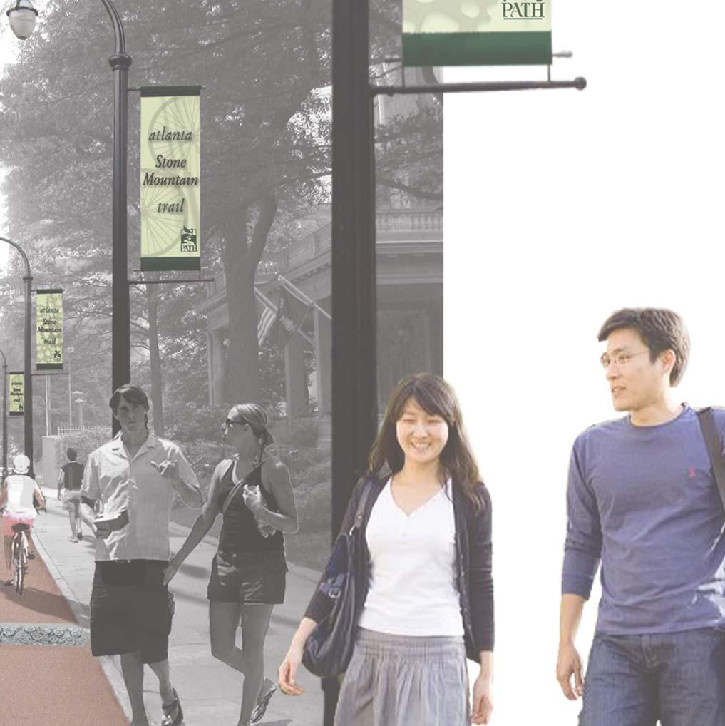
11 Raised Intersection Transition to Raised Intersection 3 Mast Arm Location 4 Corner Treatments 5 Tactile Zone 6 Bikeway/Pedestrian Crossing 7 Pedestrian Crossing 8 Light Location Proposed Drainage Inlet Location Denotes Existing Curb, Ramp, and Drainage Inlet Locations 8 Note: Typical Intersection Plan applies to all intersections except the / Piedmont Avenue intersection. 3 Bikeway/Pedestrian Crossing Street Application 1 Pedestrian Crossing Thermoplastic Application 4 Raised Intersection Corner Treatment Granite/Concrete Pavers Proposed Drainage Inlet Stormwater Pop Off Typical Intersection Plan


12 Traditional Intersection ADA Ramps 3 Mast Arm Location 4 Corner Treatments 5 Tactile Zone 6 Bikeway/Pedestrian Crossing 7 Pedestrian Crossing 8 Light Location Proposed Drainage Inlet Location Denotes Existing Curb, Ramp, and Drainage Inlet Locations Note: Typical Intersection Plan applies to all intersections except the / Piedmont Avenue intersection. 3 Bikeway/Pedestrian Crossing Thermoplastic Application 1 4 Pedestrian Crossing Thermoplastic Application Corner Treatment Granite/Concrete Pavers Proposed Drainage Inlet Stormwater Pop Off Typical Intersection Plan - Alternative
Broadway Avenue Streetscape Project City of Albert Lea. Streetscape Design Committee Meeting October 29, 2012
 Broadway Avenue Streetscape Project City of Albert Lea Streetscape Design Committee Meeting October 29, 2012 1 Presentation Outline Street Widths, Sidewalk Widths and Bump-Out Configuration Decorative
Atlanta Downtown Improvement District (ADID) h 2009 Stimulus Package
 h 2009 Stimulus Package") Atlanta Downtown Improvement District (ADID) h 2009 Stimulus Package Previously Funded Projects 1. Marietta Street and Centennial Olympic Park Drive Streetscape 2. Simpson Street and West Peachtree Street
Atlanta Downtown Improvement District (ADID) h 2009 Stimulus Package Previously Funded Projects 1. Marietta Street and Centennial Olympic Park Drive Streetscape 2. Simpson Street and West Peachtree Street
VEHICULAR AND PEDESTRIAN CIRCULATION
 This perspective sketch communicates the intended character and quality of a proposed streetscape design. Locate benches near a major intersection where people tend to gather. Seating and lighting provide
Conceptual Design. Main Street Enhancement and Extension Project. Bothell, Washington. June 11, 2009
 Conceptual Design Main Street Enhancement and Extension Project Bothell, Washington June 11, 2009 Berger/ABAM Engineers and Cascade Design Collaborative, Inc For Main Street Bothell to succeed it must
23 EA , , , , , , , LF , , ,596.
 Mast Arm Traffic Signals at Central Ave. 5th, 6th, 8th & 31st St. Engineering & Capital Improvements Department, City of St. Petersburg, FL Project No.: 11027-112 Bid date: January 10, 2012 Item Description
FREEWAY/TOURIST DISTRICT
 FREEWAY/TOURIST DISTRICT DESIGN STANDARDS FOR THE CITY OF MOUNTLAKE TERRACE March, 2014 MOUNTLAKE TERRACE FREEWAY/TOURIST DESIGN STANDARDS March, 2014 1 TABLE OF CONTENTS Introduction...1 Design Site Design
GPCID Mall Boulevard & Gwinnett Place Drive Complete Street: Sectional View of Concepts
 Sectional View of Concepts PAVEMENT FEATURES PAVEMENTS INTERSECTION INTERSECTION TREATMENTS LANDSCAPE BUFFER LANDSCAPE DESIGN GPCID CD D: GWINNETT P LACE DRIVE & MALL B COMPLETE STREET DESIGN ELEMENTS
Project will Replace: Utilities Curb Pavement Lighting. City of Madison
 Project will Replace: Utilities Curb Pavement Lighting Replace sanitary sewer main & laterals Winnebago: Existing 8 main, 1905 Linden: Existing 6 main, 1915, upsize to 8 main Atwood: Existing 12 main,
BRADENTON RIVERWALK EXPANSION MASTER PLAN
 BRADENTON RIVERWALK EXPANSION MASTER PLAN INTRODUCTION & AGENDA Process Update Community Engagement Summary Center for Active Design (CfAD) Recommendations Context and Existing Conditions Master Plan Alternatives
FDOT D4 Complete Streets
 FDOT D4 Complete Streets Context Sensitive Solutions Directs that complete street solutions will complement the context of the community. Collaborative approach to decision making, project development,
Gas Stations ottawa.ca
 Urban Design Guidelines for Gas Stations ottawa.ca Ce document est disponible en français sur ottawa.ca. This document is available in French on ottawa.ca. Approved by City Council May 24, 2006 City of
Main Street Reconstruction From Ninth Line to Stouffer Street. Town of Whitchurch-Stouffville. Public Information Centre
 Main Street Reconstruction From Ninth Line to Stouffer Street Town of Whitchurch-Stouffville Public Information Centre November 23, 2016 4:30 to 6:00 pm & 7:00 to 8:00 pm 6240 Main Street, Stouffville
City of Burlington Downtown Street Design & Construction Standards
 City of Burlington Downtown Street Design & Construction Standards Adopted April 16, 2018 b City of Burlington Downtown Street Design Standards CITY OF BURLINGTON, VT The Great Streets Initiative is a
Project Overview & Summary of Existing Conditions
 Project Overview & Summary of Existing Conditions 1 Project Overview Project Goals, History, Scope 2 Timeline / Process Overall Process & Where We Are Task Force Process & Role of Task Force Existing Conditions
The open space system should provide connective elements, relate to natural resources, and enhance the suburban character of the landscape..
 The open space system should provide connective elements, relate to natural resources, and enhance the suburban character of the landscape.. Mixed-use and infill development should maintain or enhance
SOUTH UNIVERSITY Street Design Setting a Direction for Schematic Design
 1 SOUTH UNIVERSITY Street Design Setting a Direction for Schematic Design Meeting Agenda 2 1. Project Scope 2. Design Direction 3. Design Details 4. Schedule and Construction Logistics 3 SOUTH UNIVERSITY
Project Consulting Team:
 THE DOWNTOWN CHERRYVILLE LAND USE + STREETSCAPE MASTER PLAN WAS FUNDED THROUGH THE GENEROUS DONATIONS OF THE FOLLOWING: The Community Foundation of Gaston County ElectriCities of North Carolina The Cherryville
McDonald s Restaurant - Purcellville Town of Purcellville Special Use Permit Statement of Justification July 24, 2014
 Introduction / Written Statement McDonald s Restaurant - Purcellville McDonald s Corporation is proposing to redevelop the existing McDonald s eating establishment with a drive-through located at 121 N
University Park Subdivision Street Assessment Report
 University Park Subdivision Street Assessment Report Prepared for: University Park Subdivision TABLE OF CONTENTS Introduction... 3 Existing Conditions Analysis... 4 Street Improvements... 5 Existing:...
COMPLETE GREEN STREET CHECKLIST
 COMPLETE GREEN STREET CHECKLIST This document was developed to dissect the structure of an urban street and explore opportunities to make our streets more complete while also integrating green street strategies.
STANDARD SPECIFICATIONS Book 2 ENGINEERING DRAWINGS INCLUDES ADDENDUMS
 STANDARD SPECIFICATIONS Book 2 ENGINEERING DRAWINGS INCLUDES ADDENDUMS July 23, 2018 Page 1 of 7 STANDARD LEGEND SYMBOLS (September, 1973)... AS-101A STANDARD LEGEND SYMBOLS (September, 1973)... AS-101B
GROUND LEVEL ENLARGEMENT / STREETSCAPE AT PIER AVENUE STRAND & PIER HOTEL HERMOSA BEACH HARDSCAPE MATERIAL KEY MAP PIER AVENUE
 COMPOSITE LANDSCAPE LOT B ( MAX SPACES) WILSHIRE BLVD, SUITE 0 BEVERLY HILLS, CA 0 TH STREET WILSHIRE BLVD, SUITE 0 BEVERLY HILLS, CA 0 BRYANT STREET, SUITE 00 SAN FRANCISCO, CA 0 S. FIGUEROA ST. TH FLOOR
3.13. Development Guidelines
 3.3 Landscaping Elements Landscaping should be used to frame and soften structures, define site functions, enhance the quality of the environment, and screen undesirable views. Safety, environmental impacts,
CHAPTER 8. Mrs. Zimman s Class - Central Elementary
 SUSTAINABILITY CHAPTER 8 Mrs. Zimman s Class - Central Elementary 8.1 OVERVIEW Green infrastructure also known as low impact development (LID) and environmental or sustainable site design is an environmentally
Fifth and Detroit Street Design/South University Update Capital Improvement Committee Meeting
 1 Fifth and Detroit Street Design/South University Update Capital Improvement Committee Meeting Kick-off Meeting Agenda 2 1. Introductions 2. Update on South University 3. Fifth and Detroit-project scope
Revocable Street Privilege
 Revocable Street Privilege A Revocable Street Privilege (RSP) is an authorized right to use a part of the public Right-of-Way for a private purpose. An RSP may be granted to abutting property owners for
Design Guidelines for Residential Subdivisions
 Design Guidelines for Residential Subdivisions Development Services 972-466-3225 cityofcarrollton.com This page intentionally left blank. Table of Contents Purpose... 1 Design Objectives... 1 Design Guidelines
West Dennis Center: Bass River to Old Main Street. West Dennis Business District: Old Main Street to Dennis Commons
 West Dennis Center: Bass River to Old Main Street West Dennis Business District: Old Main Street to Dennis Commons Dennisport Center: Dennis Commons to Division Street Main Street Project Goals Project
North Loop Paving. December 18th, Street Reconstruction Project. Forrest Hardy, Transportation Planner Minneapolis Public Works
 CITY OF MINNEAPOLIS Street Reconstruction Project December 18th, 2017 Forrest Hardy, Transportation Planner Minneapolis Public Works Forrest.Hardy@MinneapolisMN.Gov (612) 673-5951 Adam Hayow, Project Engineer
Kittson Parkway / Watershed Park Parking Lot
 Kittson Parkway / Watershed Park Parking Lot Date Constructed: Summer 2005 Site Location / Description: Kittson Parkway, North Delta, British Columbia. Permeable parking lot adjacent to Watershed Park;
Parapet/Formliner/Fencing
 Parapet/Formliner/Fencing Cross Parapet/Formliner/Fencing Street Aesthetic Features Context The I-290 Phase I study is evaluating improvements along 13 miles of the Eisenhower Expressway, from west of
City of Kearney Capital Improvement Update October 1, TH STREET AND 17TH AVENUE IMPROVEMENTS
 56TH STREET AND 17TH AVENUE IMPROVEMENTS FUNDING: Bonded ESTIMATED COST: $3,885,000 COMPLETION DATE: Fall 2018 SCOPE OF PROJECT: Widening of 56th Street from 6th Avenue to 19th Avenue, and widening 17th
TOWN CENTER DESIGN STANDARDS FOR THE CITY OF. August, MOUNTLAKE TERRACE TOWN CENTER DESIGN STANDARDS August,
 TOWN CENTER DESIGN STANDARDS FOR THE CITY OF MOUNTLAKE TERRACE August, 2008 MOUNTLAKE TERRACE TOWN CENTER DESIGN STANDARDS August, 2008 1 TABLE OF CONTENTS Introduction...3 Design Site Design...4 Pedestrian
Urban Land Institute Toronto / January John Street Revitalization. Public Realm Improvement Plan
 Urban Land Institute Toronto / January 2013 John Street Revitalization Public Realm Improvement Plan Contents Introduction... 1 Process... 2 Existing Conditions... 4 Analysis > Synthesis... 6 Design Principles...
Green Stormwater Infrastructure Handbook. Kristin Kerr, P.E. EOA / SCVURPPP November 29, 2018
 Green Stormwater Infrastructure Handbook Kristin Kerr, P.E. EOA / SCVURPPP November 29, 2018 Outline of Presentation Overview Handbook Contents Example Details Overview MRP requires GSI Plans to include
Edenfield Avenue Green Street Demonstration Project Neighborhood Meeting
 Edenfield Avenue Green Street Demonstration Project Neighborhood Meeting Edenfield Avenue Green Street Demonstration Project Neighborhood Meeting Road Reconstruction Elements Grant Background What is a
I-70/71 Innerbelt Project
 I-70/71 Innerbelt Project Project Progress Meeting and Design Enhancement Update November 9, 2009 Ohio Department of Transportation MS Consultants MSI Design Overview of Presentation 1. Recap Recent Project
Cleveland Park Streetscape and Drainage Improvement Project 1
 Cleveland Park Streetscape and Drainage Improvement Project 1 Urban Context Washington, D.C. Connecticut Avenue Cleveland Park Streetscape and Drainage Improvement Project 2 Neighborhood Context Contributing
Toronto Complete Streets Guidelines
 Toronto Complete Streets Guidelines 108 110 7.1 Green Infrastructure Design Principles 112 7.2 Context-Sensitive Green Streets 114 7.3 Key Green Street Elements Green infrastructure refers to natural and
DESIGN & GREEN INFRASTRUCTURE UPDATE December 13, 2016
 DESIGN & GREEN INFRASTRUCTURE UPDATE December 13, 2016 Welcome & Introduction Michael J. Finn, P.E. City Engineer Summary of Public Outreach to Date Ground the work in established principles December 2015
ARLINGTON COUNTY, VIRGINIA
 ARLINGTON COUNTY, VIRGINIA County Board Agenda Item Meeting of May 10, 2014 DATE: May 1, 2014 SUBJECT: SP #105 SITE PLAN AMENDMENT to modify several site plan conditions for Phase 3 of the Metropolitan
Fifth and Detroit Street Design May 2017 Capital Improvements Committee. DOWNTOWN Street Design
 1 Fifth and Detroit Street Design May 2017 Capital Improvements Committee Agenda 2 Review Street Configuration Prior Meeting Review Outreach Synopsis Functional Street Design Refinements Curb Edge, Turning
Citizen Advisory Group Meeting 5: Land Use April 14, 2011
 Citizen Advisory Group Meeting 5: Land Use April 14, 2011 Meeting Agenda 1. Background Review 2. Transportation Follow-up 3. PED Overlay Approach 4. Land Use Mapping 5. Group Exercise 6. Wrap-up and Next
Const. ROADS - Description
 Road Projects make up the bulk of the capital expenditures for the township. For the term of this CIP, road projects total $9,843,000 or 72.0% of the total capital expenditures for all capital projects
Technical Advisory Committee
 CULVER DOWNTOWN STREETSCAPE PLAN STREETSCAPE IDEAS REPORT 01.08.2008 Project Team Matt Crall, Transportation and Growth Management Quick Response Program Donna McCormack, City of Culver Darrell Newton,
Creative Village Design Review Committee
 N. Terry Ave. CVDRC Staff Report Creative Village Design Review Committee April 11, 2017 Case Number Agenda Item 4 W. Livingston Street Extension MPL2017-00023 ARB2017-00014 Applicant William Burns, Project
Arterial Mainstreets ottawa.ca
 Urban Design Guidelines for Development along Arterial Mainstreets ottawa.ca Ce document est disponible en français sur ottawa.ca. This document is available in French on ottawa.ca. Approved by City Council
APPENDIX F: DETAIL DRAWINGS
 APPENDIX F: DETAIL DRAWINGS DRAWING DIVISION 100 GENERAL NOTES 200 ROAD WAYS 300 TRAFFIC CONTROL 400 FENCES 500 SEDIMENT CONTROL 600 SANITARY AND STORM SEWERS 700 WATERMAIN 800 PARKS AND LANDSCAPING 900
The Capital Design Advisory Committee St. Mary s College of Maryland & Historic St. Mary s City
 The Capital Design Advisory Committee St. Mary s College of Maryland & Historic St. Mary s City Welcome April 21, 2010 Capital Design Advisory Presentation: Relocating Margaret Brent Hall Traffic Calming
REBUILD GUTTER AND ROLLED CURB TO MATCH EXISTING DETAIL. (TYPICAL) REPAIR EXISTING BENCH FINISH. RETURN TO EXISTING LOCATIONS.
 REPAIR EXISTING BENCH FINISH. RETURN TO EXISTING LOCATIONS.") MILL STREET REBUILD GUTTER AND ROLLED CURB TO MATCH EXISTING DETAIL. CURB RAMP FLUSH WITH STREET. REMOVE TWO PARKING SPACES FOR BIKE RACKS AND WASTE RECEPTACLES OVER CONCRETE SURFACE. REMOVE ONE PARKING
MILL STREET REBUILD GUTTER AND ROLLED CURB TO MATCH EXISTING DETAIL. CURB RAMP FLUSH WITH STREET. REMOVE TWO PARKING SPACES FOR BIKE RACKS AND WASTE RECEPTACLES OVER CONCRETE SURFACE. REMOVE ONE PARKING
Conclusion of Level 2 Evaluation
 Conclusion of Level 2 Evaluation The Level 2 evaluation concluded that two alternatives, Center Running Transit and Center Running Transit and New Asymmetrical met the project needs. The Center Running
Figure Example of out door dining in the public right-of-way.
 Section 2 Core Area Goal 2.2.1 To maintain and enhance the character of existing streets in the Downtown Area. Character Figure 2.2.1 Example of out door dining in the public right-of-way. A. Provide street
City of Bristol Route 6 Corridor Implementation Program
 City of Bristol Route 6 Corridor Implementation Program FITZGERALD & HALLIDAY, INC. Innovative Planning, Better Communities June 2017 Route 6 Corridor Plan IMPLEMENTATION PROGRAM The following Implementation
Maplewood Avenue Downtown Complete Street Project
 Maplewood Avenue Downtown Complete Street Project Second Public Meeting January 24, 2018 Welcome and Introduction of Project Team City Planning and Public Works Staff City of Portsmouth Juliet Walker Planning
Spring 2018 Construction Update
 Spring 2018 Construction Update Ward 3 Southwest Engineering Department Locust Street Bridge over the Des Moines River The Locust Street Bridge over the Des Moines River project is being let through the
Building Great Neighbourhoods LAURIER HEIGHTS
 Building Great Neighbourhoods LAURIER HEIGHTS Building Great Neighbourhoods Building Great Neighbourhoods (BGN) is a longterm framework that coordinates and integrates the efforts of three City of Edmonton
Chapter 6. Green Streets
 Chapter 6. Green Streets Description Green streets are designed in a holistic manner that minimizes impervious surfaces, emphasizes landscaped elements, includes measures for enhancing water quality, while
Lockport Streetscape Plan Primary Streetscape Design 10th Street to 9th Street
 1 0 t h S T R E E T Limestone Retaining Wall Lighting Control Box, Typ. EMBERS Awning Overhang SHAWANDAS NAIL SALON CITY OF LOCKPORT COMMUNITY DEVELOPMENT CENTER PEOPLES CLEANERS HIERRADA ACCNTG CANAL
OPPORTUNITIES AND CONSTRAINTS - OXBOW PARK ENTRANCE AND PUT-IN
 OPPORTUNITIES AT OXBOW EXISTING WETLANDS Site is undeveloped and we can design a park that works well from the start. SAND BEACH Potential to eliminate invasive species. DEBRIS (CONCRETE, OLD CARS) VEGETATION
CITY OF OZARK STANDARD DRAWING DETAILS FOR PUBLIC IMPROVEMENTS
 CITY OF OZARK STANDARD DRAWING DETAILS FOR PUBLIC IMPROVEMENTS 2010 EDITION CITY OF OZARK, MISSOURI REVISIONS TO THE 2009 EDITION The following revisions have been made to the 2009 edition of the city
SOUTH UNIVERSITY Street Design Alternatives in Progress
 1 Alternatives in Progress 2016.01.20 Meeting Agenda 2 1. Progress & Schedule 2. Utilizing the Street Design Manual 3. Site Characteristics and Input Received 4. Street Geometry What can we accomplish
Designing for Sustainability: A Consultant s Perspective
 Session 462 Asphalt Pavement Sustainability Designing for Sustainability: A Consultant s Perspective Timothy A. Bevan, P.E. / CH2M HILL Transportation Research Board 87th Annual Meeting January 13-17,
FROM DUPONT CIRCLE NORTH TO CALIFORNIA STREET, NW. Welcome!
 FROM DUPONT CIRCLE NORTH TO CALIFORNIA STREET, NW Welcome! Meeting Agenda 6:00 PM Open House 6:30 PM Presentation 7:00 PM Open House / Q&A at the Boards Project Design Team Connecticut Avenue, NW Project
CONFORMED AGREEMENT INCORPORATED REVISIONS PER AMENDMENT DATED: APRIL 2, 2013 FOR REFERENCE
 CONFORMED AGREEMENT INCORPORATED REVISIONS PER AMENDMENT DATED: APRIL 2, 2013 FOR REFERENCE CITY STREETS AS PART OF STATE HIGHWAYS GUIDELINES REACHED BY THE WASHINGTON STATE DEPARTMENT OF TRANSPORTATION
2040 Long Range Transportation Plan
 2040 Long Range Transportation Plan Adopted: April 15, 2013 APPENDIX D HIGHWAY NEEDS PLAN PROJECTS FREDERICKSBURG Existing and Committed Projects Fall Hill Avenue/Mary Washington Blvd. (Fredericksburg)
BUSINESS DISTRICT DESIGN GUIDELINES
 Des Plaines, Illinois Prepared for the City of Des Plaines by: The Lakota Group Laurie Marston, AICP March 2005 Section 6: Landscaping Business District Design Guidelines LANDSCAPING GUIDELINES The following
Design Guidelines for the Route 30 Corridor Master Plan: Subdivision and Land Development Elements
 Design Guidelines for the Route 30 Corridor Master Plan: Subdivision and Land Development Elements East Whiteland Township- Chester County, PA Prepared by: Draft: May 7, 2018 Design Guidelines for the
PennDOT Public Meeting. S.R. 3044, Section A01 Castle Shannon Boulevard Roadway Improvement Project
 PennDOT Public Meeting S.R. 3044, Section A01 Castle Shannon Boulevard Roadway Improvement Project Mt Lebanon Township, Allegheny County Mt Lebanon Township Municipal Building November 6, 2014 1 Project
SDOT DPD. SDOT Director s Rule DPD Director s Rule DCLU DR SED DR of 7 CITY OF SEATTLE
 SDOT SDOT Director s Rule 2-07 DPD Applicant: CITY OF SEATTLE Page 1 of 7 Supersedes: DCLU DR 11-93 SED DR 93-4 Seattle Department of Transportation (SDOT) Department of Planning and Development (DPD)
Lambeth Main Street Streetscape Improvements
 Lambeth Main Street Streetscape Improvements Open House October 5th, 2017 Agenda 1. Introduction 2. Project Background 3. Context 4. Project Objectives 5. Design Principles & Approach 6. Streetscape Design
CRA Five Year Capital Improvement Plan. September 2, 2015
 CRA Five Year Capital Improvement Plan September 2, 2015 Downtown CRA Recap Introduction Downtown Capital Improvement Projects: $2.6M available for FY 2016. Includes the recent loan of $2.0M. DOWNTOWN
THE CORPORATION OF THE CITY OF VAUGHAN MAJOR MACKENZIE STREETSCAPE STUDY
 THE CORPORATION OF THE CITY OF VAUGHAN MAJOR MACKENZIE STREETSCAPE STUDY STANTEC CONSULTING LTD. 300-675 Cochrane Drive, West Tower Markham, ON L3R 0B8 Tel: (905) 944-7777 Fax: (905) 474-9889 April 2010
Streets Vision
 streets 86 2.9 Vision : The Most Prevalent and Important Public Spaces Fixed routes of human travel have served as corridors for commerce and places for human interaction from the earliest trails and foot
Commercial Site Plan Review Checklist
 Commercial Site Plan Review Checklist Updated 1/5/2015 Project Name: EPM #: _ Street: Contact: Phone: Date Submitted: _ Fax: Reviewer: Email: First Review: Second Review: _ Third Review: Reviews Required
open house 3 CITY OF SALEM Downtown Streetscape Plan
 open house 3 Streetscape concepts CITY OF SALEM Downtown Streetscape Plan analysis concepts we are here refined concepts & document Feb 13th 1 2 3 apr 18th KICKOFF OPEN HOUSE Streetscape Work Group Walking
Bethlehem Pike Streetscape Master Plan
 Bethlehem Pike Streetscape Master Plan Prepared for Springfield Township October 2008 By Michael Baker Jr., Inc. Carter Van Dyke Associates Table of Contents 1. Introduction 3 2. General Corridor Wide
Potential Green Infrastructure Strategies May 6, 2015 Workshop
 Potential Green Infrastructure Strategies May 6, 2015 Workshop Background The City of Cortland is developing the Tioughnioga Urban Headwaters Green Infrastructure Action Plan with funding from the National
CHAPTER 12 DESIGN GUIDELINES FOR PUBLIC IMPROVEMENTS
 CHAPTER 12 DESIGN GUIDELINES FOR PUBLIC IMPROVEMENTS Introduction This chapter provides design guidelines for public sector improvements in the downtown. This includes streetscape design, as well as the
Roanoke Rapids Streetscape Master Plan. City Council Presentation
 SCHEDULE: Stakeholder Meeting/Kick off November,2016 Master Planning Phase (November March 2017) Public Meeting #1 December 13, 2016 Review Meeting with Key Stakeholders Refine Concepts Based on Input
Community Engagement Committee Meeting #1 December 10, :30pm-8:30pm
 Community Engagement Committee Meeting #1 December 10, 2014 6:30pm-8:30pm Welcome and Introductions Dana Murdoch Minneapolis Park and Recreation Board Project Manager Ryan French Walker Art Center Director
180 ZONING 180. ARTICLE XLII STREETSCAPE ENHANCEMENT OVERLAY ( SEO ) DISTRICT [Added Ord. No. 1086]
![180 ZONING 180. ARTICLE XLII STREETSCAPE ENHANCEMENT OVERLAY ( SEO ) DISTRICT [Added Ord. No. 1086]](/thumbs/75/72360049.jpg "180 ZONING 180. ARTICLE XLII STREETSCAPE ENHANCEMENT OVERLAY ( SEO ) DISTRICT [Added Ord. No. 1086]") 180 ZONING 180 ARTICLE XLII STREETSCAPE ENHANCEMENT OVERLAY ( SEO ) DISTRICT [Added 4-6-2016 Ord. No. 1086] 180.145. SEO DISTRICT 180.145.1. Intent. The SEO DISTRICT Regulations are intended to address
180 ZONING 180 ARTICLE XLII STREETSCAPE ENHANCEMENT OVERLAY ( SEO ) DISTRICT [Added 4-6-2016 Ord. No. 1086] 180.145. SEO DISTRICT 180.145.1. Intent. The SEO DISTRICT Regulations are intended to address
APPEARANCE REVIEW BOARD
 June 18, 2015 Appearance Review Board APPEARANCE REVIEW BOARD MEETING INFORMATION Location Sustainability Conference Room 2nd Floor, City Hall One City Commons 400 South Orange Avenue Time 2:00p.m. Board
Rt. 29 Solutions Project Delivery Advisory Panel. December 3, 2015
 Rt. 29 Solutions Project Delivery Advisory Panel December 3, 2015 Agenda item 1: Introductions Project Delivery Advisory Panel Technical Team 2 Agenda item 2: Interaction and Feedback Live Streaming Nov
Table of Contents. Elm Avenue Improvement Plan City of Waco, Texas. Introduction 1. Existing Context 1 Figure 1 2.
 Table of Contents Introduction 1 Existing Context 1 Figure 1 2 Plan Guidelines 3 Future Urban Form 4 The West-End 4 Main Street 6 The East-End 7 Figure 2 9 Public Improvement Recommendations 7 General
Nuts and Bolts (or Gravel and Asphalt) of the Main Street Project
 of the Main Street Project") Nuts and Bolts (or Gravel and Asphalt) of the Main Street Project What is the Main Street Project? The Main Street Project is a roadway project that addresses pavement, infrastructure and safety issues
Nuts and Bolts (or Gravel and Asphalt) of the Main Street Project What is the Main Street Project? The Main Street Project is a roadway project that addresses pavement, infrastructure and safety issues
The Lincoln Neighborhood Corridor Plan. The LiNC
 October 1, 2014 Planning Commission Study Session The Lincoln Neighborhood Corridor Plan The LiNC Purpose of Tonight s Meeting Introduction to The LiNC Review of Existing Conditions and Community Identified
St. Clair Avenue West Area Transportation Master Plan
 1 (Between Keele Street and Old Weston Road) Public Information Centre 1 December 2, 2015 2 Welcome Welcome to the first Public Information Centre for the St. Clair Avenue West Area. The panels will present
ROME CANALWAY TRAIL ERIE BOULEVARD WEST AND SOUTH CHARLES STREET ROME, NEW YORK DELTA PROJECT NO SEPTEMBER 2017 ISSUED FOR BID
 ROME CANALWAY TRAIL ERIE BOULEVARD WEST AND SOUTH CHARLES STREET ROME, NEW YORK 13440 DELTA PROJECT NO. 2017.226.001 SEPTEMBER 2017 ISSUED FOR BID INDEX OF DRAWINGS GENERAL CIVIL ARCHITECT/ENGINEER PROJECT
 PLANNING COMMISSION STAFF REPORT MEETING DATE: PROJECT NUMBER: ZONE: REQUEST: ADDRESS: APPLICANT: PREPARED BY: 6 July 2017 D-17-006 Commercial Corridorr Design Review Approval a parking lot expansion 26
Urban Design Brief. 875 Wellington Road. Proposed One-Storey Fast Food Restaurant and Two-Storey Restaurant. Wellington Harlech Centre Inc.
 Urban Design Brief 875 Wellington Road Proposed One-Storey Fast Food Restaurant and Two-Storey Restaurant Wellington Harlech Centre Inc. Prepared By: (519) 433-7587 info@yorkdev.ca May 3 rd 2013 1 Table
Letter of Credit Itemized Cost Estimate For: 100% Site Development Costs
 Letter of Credit Itemized Cost Estimate For: 100% Site Development Costs The following form is to be filled out by the Project Consultant(s) and submitted to the City of Kitchener, Planning Division for
City of Ketchum P.O. Box East Ave. N. Ketchum, ID 83340
 City of Ketchum P.O. Box 2315 480 East Ave. N. Ketchum, ID 83340 June 10, 2015 Mayor Jonas and City Councilors City of Ketchum Ketchum, Idaho Mayor Jonas and City Councilors: Sidewalk Discussion Introduction/History
Index to Projects by Project Name
 Index to Projects by Project Name Project # PROJECT NAME PAGE 2134 2119 PR-1109 Clayton Road (Market Street to Oakland Avenue) Sidewalk Repair 911 System Replacement and Dispatch Room Remodel ADA Barrier
MAIN STREET DESIGN GUIDELINES CONTEXT
 MAIN STREET DESIGN GUIDELINES CONTEXT VISION The re-imagining of Main Street offers an unparalleled opportunity to strengthen and link Fredericton North through the integration of local neighbourhoods,
Town of Yucca Valley Capital Improvement Projects Report July 24, 2014
 Town of Yucca Valley Capital Improvement Projects Report July 24, 2014 SR 62 Traffic and Pedestrian Improvements from Apache Trail to Palm Avenue (PLHD) The project includes construction of curbs, gutters,
July 12, Columbus City Council City Hall 90 West Broad Street Columbus, OH RE: I-70/71 Columbus Crossroads Project
 OHIO DEPARTMENT OF TRANSPORTATION DISTRICT 6 400 EAST WILLIAM STREET DELAWARE, OHIO 43015 800.372.7714 Columbus City Council City Hall 90 West Broad Street Columbus, OH 43215-9015 RE: I-70/71 Columbus
Shell Beach Road Streetscape Frequently asked Questions
 Shell Beach Road Streetscape Frequently asked Questions General What is the Shell Beach Road Streetscape Improvements Project? The overall goal of the Shell Beach Road Streetscape Improvement project is
DESIGN CRITERIA PACKAGE
 RFQ: 17-C-00003 DESIGN-BUILD SERVICES FOR THE DESIGN CRITERIA PACKAGE PREPARED BY: JAMES E. JACKSON, JR. AIA CITY ARCHITECT CONTRACT ADMINISTRATION DEPARTMENT and INTERFLOW ENGINEERING, L.L.C DESIGN CRITERIA
Note: Staff reports can be accessed at Special Permit Application No.
 The Maryland-National Capital Park and Planning Commission Prince George's County Planning Department Development Review Division 301-952-3530 Note: Staff reports can be accessed at www.mncppc.org/pgco/planning/plan.htm.
SFMTA PHELAN LOOP AND PUBLIC PLAZA PHELAN OCEAN AVENUE
 SFMTA Municipal Transportation Agency Image: a bus in front of the Palace of the Legion of honor SFMTA PHELAN LOOP AND PUBLIC PLAZA PHELAN AVENUE @ OCEAN AVENUE Community Meeting May 23, 2012 San Francisco,