Northwest Rail Corridor and US 36 BRT Development Oriented Transit Analysis 4.4 STATION AREA FINDINGS
|
|
|
- August Strickland
- 5 years ago
- Views:
Transcription

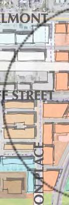
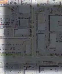
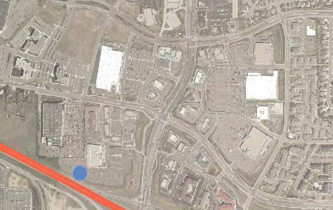
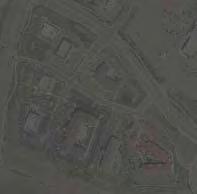
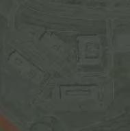
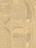
1 4.4 STATION AREA FINDINGS Each station is different, and each one requires a separate set of recommendations based on the vision for the site. This section outlines an initial TOD strategy and recommendations for each station, along with the challenges that must be overcome to implement TOD. Each number represents a design or policy recommendation, and is shown in the corresponding planning map for each station. The stations are discussed in progression from north to south. Note that the numbers on the station area maps correspond with the recommendations in the text Longmont The 1st and Terry site was selected as the preferred station location in the Longmont Diagonal Rail Project EE in December Subsequently it the only Longmont station site under evaluation in the Northwest Rail EE, and is the subject of this report. Exhibit 4-2: Flour Mill, Longmont Station Area Character: The proposed Longmont station is located at 1st and Terry Streets two blocks from the center of downtown Longmont and the commercial areas along Main Street (US 287). The properties north of 1st Avenue are likely to redevelop on their own without transit due to their proximity and linkage to downtown. The plan for this station area should be transit supportive, and complement the vision for the downtown and for the larger city. Currently, a developer is moving forward with a plan for adaptive reuse of the Flour Mill site (Exhibit 4-2) as a residential project. This site will serve as a historic anchor and will contribute to the unique identity of the site. The City has a finance tool in place through designation of the site as an Urban Renewal Area. The St. Vrain Greenway provides a trail amenity within walking distance, just south of the station. Pedestrian improvements are underway to provide regional trail connections east and west of the station site. Challenges: Originally built in 1915, the Flour Mill is a Longmont icon. The city is interested in facilitating reuse of the site. The site is the end-of-line station for the Northwest Rail corridor under the FasTracks Plan. Demand for parking could create an end-of-line commuter parking station rather than a pedestrian-oriented transportation hub for the city. The location of the station platforms are not visible from Main Street, making wayfinding for the pedestrian difficult between downtown and the station. Circulation through the site is concentrated on Main, Terry and 1st Avenue. Coffman street extends to 1st, but does not continue to the south. Final 4-6 July 2007


")

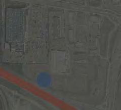
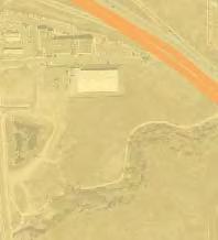
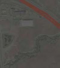
2 The 100-year floodplain along the St. Vrain Greenway covers a majority of the station area. An electrical substation is located in an area adjacent to the Flour Mill and the station. The substation would be expensive to relocate to a different location. Exhibit 4-3: Station Location Station Area The 1st/Terry Station (rather than Twin Peaks Mall) location is the subject of this report because it is the only Longmont area station location under evaluation in the NW Rail EE. Corridor Station Area Location Final 4-7 July 2007


 1)")


 2) Create a")
3 Northwest Rail Corridor and US 36 BRT Exhibit 4-4: Station Recommendations Longmont Station Area Floodplain 7 1 City of Longmont 5 3 Historic Depot 1st Ave T TOD 1/4 Mile Main ST Coffman ST Terry ST 2 Pratt Ave ve ea Pric Kimbark ST 1/2 Mile T 6 Station Residential 4 Civic Parking Boston Ave. Floodplain Residential 8 Mixed-Use Rail Corridor Floodplain Floodplain is not illustrated outside of the station study area. Please note that floodplain is not intended for infrastructure or legal purposes. N Recommendations (numbers correspond to station area map, Exhibit 4-4) 1) Consider the Flour Mill as an historic anchor for the station. Utilize the Flour Mill and surrounding station as a gateway into downtown from the south. Responsibility: Longmont, Property owner/developer Timeframe: Short-term (Prior to the final draft of the Northwest Rail EE and US 36 FEIS publication) 2) Create a north / south pedestrian linkage along Coffman Street to connect downtown, the station and the Greenway. Final 4-8 July 2007
4 Responsibility: Longmont Northwest Rail Corridor and US 36 BRT Timeframe: Long-term (prior to project construction) 3) Investigate the opportunity to move the station platforms toward Main Street to enhance visibility. This would require a design variance through RTD (and approval by BNSF and CDOT) to put the platforms within 300 feet of a roadway crossing. Responsibility: RTD, EE design team Timeframe: Short-term (prior to the final draft of the Northwest Rail EE and US 36 FEIS publication) 4) Evaluate opportunities to reconfigure parking to support TOD south of 1st Avenue (focus new development along 1st Avenue instead of parking). Responsibility: RTD, Longmont, EE design team Timeframe: Short-term (prior to the final draft of the Northwest Rail EE and US 36 FEIS publication) 5) Keep Main Street in its existing configuration as an at-grade crossing with the railroad and proposed commuter rail. Responsibility: Longmont, CDOT, EE design team Timeframe: Short-term (prior to the final draft of the Northwest Rail EE and US 36 FEIS publication) 6) Investigate feasibility of acquiring and moving historic BNSF depot presently east of Main Street to a location that enhances the station presence and relationship to Main Street. Responsibility: Longmont Timeframe: Long-term (prior to project construction) 7) Evaluate on-street bus drop off areas along 1st Avenue and Coffman Street to allow for development to occur closer to the station. Responsibility: EE design team, RTD, Longmont Timeframe: Short-term (prior to the final draft of the Northwest Rail EE and US 36 FEIS publication) Final 4-9 July 2007
5 8) Assess, design and implement drainage improvements along the St. Vrain Greenway to allow residential development south of station. RTD should confirm floodplain influence on transit improvements as part of the EE process. Responsibility: Longmont, RTD, EE Design Team Timeframe: Long-term (prior to project construction) General Recommendations (not highlighted on station area map) Identify City Capital Improvement Projects near the station area that enhances access and the ability to support transit. Responsibility: Longmont Timeframe: Short-term to long-term (between the final draft of the Northwest Rail EE and US 36 FEIS publication and project construction) Conduct a study to determine impacts of existing drainage/floodplain issues on TOD potential. Responsibility: Longmont Timeframe: Short-term (prior to the final draft of the Northwest Rail EE and US 36 EIS publication) Adopt TOD/MU Overlay District zoning language and a subsequent map amendment for the station area and downtown to provide greater incentives for quality transit supportive development. Responsibility: Longmont Timeframe: Short-term (prior to the final draft of the Northwest Rail EE and US 36 FEIS publication) Develop an infrastructure master plan based on the City s TOD/MU Overlay zoning for the station area and downtown that identifies the infrastructure needs for development opportunities. Final 4-10 July 2007

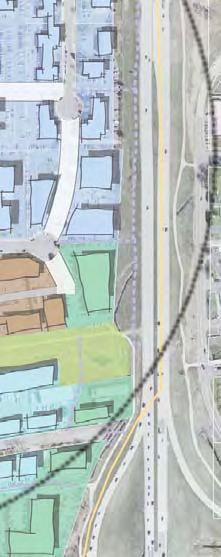
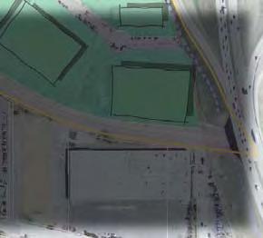
6 Responsibility: Longmont Northwest Rail Corridor and US 36 BRT Timeframe: Short-term (prior to the final draft of the Northwest Rail EE and US 36 FEIS publication) Boulder Transit Village Station Area Character: The Boulder Transit Village site is situated in east Boulder within an area of commercial and industrial uses. The City of Boulder, in coordination with RTD, has undertaken an extensive planning program for the station area. The overall plan will be phased to include local and regional buses, pedestrian and bicycle network connections, a park-n-ride, affordable housing, and commercial development. The regional bus/brt station will be located near 30th and Pearl streets on a portion of an 11-acre site owned by the City and RTD. The Steelyards development is located in close proximity to the TOD station area (Exhibit 4-5). RTD and the City of Boulder received a federal grant to design and construct the bus facility near 30th and Pearl. This process will be separate from the EIS process. Construction of the bus facility is expected to be complete by Challenges: The area will need to serve the commuter, for both BRT and commuter rail. Integration of the transit facilities into the site, including direct and efficient access, must not detract from the TOD potential. The area has a number of different property owners making comprehensive TOD implementation difficult and making comprehensive plan for TOD even more important. The site is within a centrally located land area in Boulder. However, the site is surrounded by aging industrial uses on large lots. The bus facility will be constructed prior to the commuter rail. Connections between the two stations need to be closely coordinated over time. Exhibit 4-5: Steelyards Project, Boulder The Steelyards Project is located west of the proposed commuter rail station and sits on a 10 acre site that was previously a steel fabrication facility. Final 4-11 July 2007


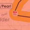
7 Exhibit 4-6: Station Area Map Station Area Corridor Station Area Location Final 4-12 July 2007


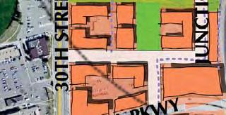
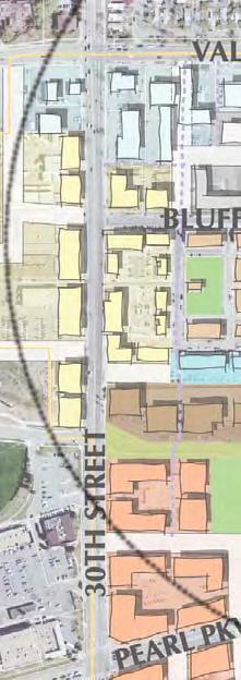
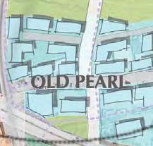

8 Northwest Rail Corridor and US 36 BRT Exhibit 4-7: Station Area Recommendations Boulder Transit Village Station Area T T 2 1/4 Mile Goose Creek Trail 3 1/2 Mile T Rail Corridor Station Mixed Use 1 Mixed Use 2 N Final Industrial Mixed Use 1 High Density Residential 1 Industrial Mixed Use 1 Medium Density Residential High Density Residential 2 Office Industrial 4-13 July 2007
9 Recommendations (Numbers correspond to the station area map, Exhibit 4-7) 1) Evaluate pedestrian crossing alternatives to and from platform for urban design integration with the plaza, and the construction requirements for a below grade versus above grade design. Determine configuration and location of kiss-n-ride and bus transfer facilities for rail station. The city supports a below-grade underpass at the Boulder Transit Village rail platform. Responsibility: EE design team, RTD, Boulder Timeframe: Short-term (prior to the final draft of the Northwest Rail EE and US 36 FEIS publication) 2) Develop consensus for a comprehensive approach to transit parking at the bus and rail stations that integrates with overall development of the Boulder Transit Village and meets transit access needs. Responsibility: RTD, Boulder, EE design team Timeframe: Short-term (prior to the final draft of the Northwest Rail EE and US 36 FEIS publication) 3) Investigate the feasibility of integrating the historic depot with the station plaza at the termination of Bluff Street (Exhibit 4-8). Responsibility: Boulder Timeframe: Short-term to long-term (between the final draft of the Northwest Rail EE and US 36 FEIS publication and project construction) 4) Investigate the potential to shift the rail platforms to center at the end of Bluff Street to create a focal point at the station platforms. Coordinate this analysis with the location / design of a pedestrian crossing of the tracks. Responsibility: EE design team, RTD, Boulder Timeframe: Short-term (prior to the final draft of the Northwest Rail EE and US 36 FEIS publication) 5) Determine a preferred alignment for Junction Place between Pearl Parkway and Bluff Street. Emphasize Junction Place as a key part of the circulation route within the site while maintaining the street as a pedestrian friendly linkage. Responsibility: Boulder, RTD Final 4-14 July 2007

 Functional Size of Plaza - approximately.")

10 Timeframe: Short-term: (prior to the final draft of the Northwest Rail EE and US 36 FEIS publication) General Recommendations (not highlighted on station area map) Establish financing mechanisms to capture value from new development for infrastructure improvements. Responsibility: Boulder Timeframe: Short-term (prior to the final draft of the Northwest Rail EE and US 36 FEIS publication) Exhibit 4-8: Boulder Depot Design Concept E BLUFF STREET G A +/- 100 FEET JUNCTION PLACE +/- 180 FEET B C D JUNCTION PLACE F LEGEND A Depot Plaza Approximate size of plaza -.6 ac (including stairs & ramps) Functional Size of Plaza - approximately.4 ac B Historic Depot with Pavillion C RTD Communter Rail Platform (both sides) D Underpass with Stairs and Ramp (length up to 300 feet) E Local Bus Staging - 2 buses each side - 82 ft ROW F Phase 1 Kiss 'N' Ride and Potential Bus Staging G Phase 2 Kiss 'N' Ride KEY MAP D R A F T WILDERNESS PLACE NOTE: FINAL LOCATION OF BUS STAGING AND UNDERPASS/ OVERPASS TO BE DETERMINED DURING FINAL DESIGN, INCLUDING THE NW RAIL ENVIRONMENTAL ASSESSMENT. GOOSE CREEK N (Source: City of Boulder) CONCEPTUAL DIAGRAM DEPOT PLAZA AND TRANSIT BLUFF AND JUNCTION PLACE 1"=160' APRIL 10, 2007 Final 4-15 July 2007

11 Investigate fencing options and alternatives to fencing along the rail corridor to address potential environmental and aesthetic impacts, while maintaining strong consideration of operations, systems safety and security. Alternatives to fencing would need to be analyzed as part of the Northwest Rail EE and are subject to approval by the BNSF Railroad and RTD s systems safety and security staff. Responsibility: EE design team, City of Boulder, Boulder County, RTD Timeframe: Short-term (prior to the final draft of the Northwest Rail EE and US 36 EIS publication) Downtown Louisville Station Area Character: The Louisville rail station is proposed northeast of downtown Louisville in an area referred to as the Highway 42 Revitalization Area. The historic downtown serves as the heart of activity and commerce for the City. Louisville has just recently designated an urban renewal district extending from S. Boulder Road to Pine Street, and from Highway 42 to Main Street. The urban renewal district provides a catalyst for redevelopment incentives and TOD implementation (Exhibit 4-11). Little Italy and Miner s Field are historic single-family neighborhoods located north and south of the station respectively that need to be protected from future development encroachment that would threaten their historic character. The Louisville Sports Complex east of Highway 42 may provide a unique opportunity to provide overflow parking for the station. This would encourage pedestrian activity through the station area, but would first require safe pedestrian connections Exhibit 4-9: Louisville across Highway 42 at key intersections. Challenges: The proposed location of the commuter rail platforms would not directly connect the TOD opportunity site with downtown Louisville. Exhibit 4-9 shows new infill development in the downtown. Access is limited from Highway 42 because it is a wide arterial with few pedestrian connections. Highway 42 is currently 2 lanes, and is expected to be widened to 4 lanes. A major storm sewer line bisects the property east of the alignment. New development in Louisville s historic downtown. The station will be located northeast of this area. Final 4-16 July 2007


12 A growth restriction in the City limits the future population to approximately 23,000 persons, city-wide. Future development on this site would require a shift in density to focus residential uses around the station. Exhibit 4-10: Station Area Map Station Area Corridor Station Area Location Final 4-17 July 2007
 Main St Louisville Station Area Little Italy Louisville Middle School GRIFFITH ST 1 2 2 1 LAFAYETTE ST. 5 SHORT ST. T SOUTH ST. T WALNUT ST. Sports Complex 3 CALEDONIA ST.")
13 Northwest Rail Corridor and US 36 BRT Exhibit 4-11: Station Area Recommendations HWY. 42 (96TH ST.) Main St Louisville Station Area Little Italy Louisville Middle School GRIFFITH ST LAFAYETTE ST. 5 SHORT ST. T SOUTH ST. T WALNUT ST. Sports Complex 3 CALEDONIA ST COAL CREEK TRAIL 7 T Residential Miner s Field SPRUCE ST. Station Downtown EMPIR E RD. Downtown 1/4 Mile Mixed-Use Commercial N 1/2 Mile Parking Rail Corridor Recommendations (Numbers correspond to the station area map, Exhibit 4-11) 1) Refine parking needs for the station to reflect Louisville s desire for less spaces located adjacent to the rail alignment with shared parking east of Highway 42 (if viable). Responsibility: RTD, Louisville, Boulder County, EE design team Timeframe: Short-term (prior to the final draft of the Northwest Rail EE and US 36 FEIS publication) 2) Encourage residential development south of Griffith Street along Highway 42. Create a density gradient from the single-family neighborhoods to the denser TOD urban core. Responsibility: Louisville Final 4-18 July 2007
14 Timeframe: Short-term to long-term (between the final draft of the Northwest Rail EE and US 36 FEIS publication and project construction) 3) Concentrate retail development along Short Street with frontage along Highway 42. This development should complement, rather than detract from, existing retail uses in downtown west of the alignment. Responsibility: Louisville Timeframe: Short-term to long-term: (between the final draft of the Northwest Rail EE and US 36 FEIS publication and project construction) 4) Investigate designing a split platform to enhance connectivity to both downtown and the TOD opportunity site, and to potentially minimize impacts to properties along Front Street and the Miner s Field neighborhood. Responsibility: RTD, EE design team Timeframe: Short-term (prior to the final draft of the Northwest Rail EE and US 36 FEIS publication) 5) Confirm the concept of a pedestrian underpass as the preferred crossing design to enhance pedestrian connectivity and support TOD. A pedestrian underpass, rather than overpass, would protect the views to downtown. Responsibility: RTD, Louisville, EE design team Timeframe: Short-term (prior to the final draft of the Northwest Rail EE and US 36 FEIS publication) 6) Create a signalized intersection at Short Street and Highway 42 to allow pedestrian access from overflow parking. Determine impacts of long-term improvements to Highway 42 (possible widening) and work to minimize effects on TOD. Responsibility: Louisville, Boulder County, CDOT Timeframe: Short-term to long-term: (between the final draft of the Northwest rail EE and US 36 FEIS publication and project construction) 7) Refine conceptual design of the bus transfer facilities to allow on-street access from downtown along Front Street, and from Highway 42 using a new connection via South and Short streets. Final 4-19 July 2007
15 Responsibility: RTD, EE design team Northwest Rail Corridor and US 36 BRT Timeframe: Short-term (prior to the final draft of the Northwest Rail EE and US 36 FEIS publication) 8) Utilize finance mechanisms, such as the current Urban Renewal District, to finance infrastructure improvements. Responsibility: Louisville Timeframe: Short-term to Long Term (between the final draft of the Northwest Rail EE and US 36 FEIS publication and project construction) McCaslin Boulevard Station Area Character: The McCaslin Boulevard BRT Station is planned off of US 36 in the Town of Superior (Exhibit 4-13). A pedestrian bridge links to Louisville north of US 36. Station parking is surrounded by large format retail. The Town of Superior plans to construct a town center east of McCaslin Boulevard on vacant land. The fear for this station is that the new Town Center will function as a transit adjacent development (TAD) instead of a TOD. In a TAD configuration, development is located next to the transit facility without fully integrating transit and land use together. Therefore, strong and convenient pedestrian connections are necessary to make this configuration viable. One alternative consideration discussed in the workshop involves shifting the pedestrian bridge and BRT station south to connect the future Town Center across US 36 (Exhibit 4-14). Capturing the opportunity presented by moving the station would require a higher degree of planning coordination between the jurisdictions involved. The station parking north of US 36 in Louisville is surrounded by large format retail. The City s Comprehensive Plan designates the area around the station as a long-term redevelopment opportunity area. The City s desire is to maintain employment and commercial uses with an emphasis on TOD, and to create a gateway into Louisville at this location. Challenges: The existing retail development is not configured to serve as TOD. A struggle to secure sales tax revenue has created an overabundance of retail and l less of an emphasis on residential; both of which are needed for TOD. The distance between the new Superior Town Center planned east of McCaslin and the Superior BRT Station west of McCaslin creates challenges for pedestrian connectivity. Final 4-20 July 2007


16 Exhibit 4-12: Superior / Louisville Pedestrian Bridge Pedestrian bridge connecting Louisville and Superior over US 36, west of the McCaslin interchange. This bridge currently connects parking areas and large format retail across US 36. Exhibit 4-13: Station Area Map Station Area Station Area Corridor Station Area Location Final 4-21 July 2007


17 Northwest Rail Corridor and US 36 BRT Exhibit 4-14: Station Area Recommendations McCaslin Blvd Station Area Station Alternative Station Opportunity Area Mixed-Use Commercial Parking B B N Recommendations: (Numbers correspond to the station area map, Exhibit 4-14) 1) Evaluate the market potential and develop coordinated plans for re-use of sites north of the station in Louisville. Ensure that new development is TOD friendly and connects to the station. Responsibility: Louisville Timeframe: Long-term (prior to project construction) 2) Final Evaluate how the existing retail center and the park-n-ride south of US 36 can better 4-22 July 2007
18 support each other. Create pedestrian connections to surrounding retail uses. Responsibility: Superior Timeframe: Short-term to long-term (between the final draft of the Northwest Rail EE and US 36 FEIS publication and project construction) 3) Create a multi-modal connection to the McCaslin park-n-ride from the new Superior Town Center. Responsibility: Superior, RTD Timeframe: Long-term (prior to project construction) 4a) Provide Superior and Louisville with background information on the siting of the McCaslin park-n-ride and pedestrian bridge. Responsibility: RTD Timeframe: Immediate (within the next three months) 4b) Evaluate the feasibility of shifting the existing pedestrian bridge south to better serve future development. Responsibility: Superior Timeframe: Short-term (prior to the final draft of the Northwest Rail EE and US 36 FEIS publication) 5) Improve and extend pedestrian connections along 2nd Avenue. This would improve the east-west connections between the future Town Center and the Superior Marketplace retail center west of McCaslin. Responsibility: Superior Timeframe: Short-term to Long-term (between the final draft of the Northwest Rail EE and US 36 FEIS publication and project construction) 6) Develop and adopt a master plan for the new Superior Town Center. Responsibility: Superior Timeframe: Short-term (prior to the final draft of the Northwest Rail EE and US 36 FEIS publication) Final 4-23 July 2007
Northwest commuter rail station US 36 BRT. Westminster Station
 Northwest commuter rail station Westminster Station US 36 BRT Westminster Center US 36 & Church Ranch Broomfield Flatiron/96 th St. US 36 & McCaslin Table Mesa Boulder Junction 13-month effort that will
Transportation. Strategies for Action
 Transportation A major priority for the Overlake Neighborhood is to develop a multimodal transportation system. To achieve this system, a balance has to be found among travel, circulation and access needs;
Northwest Rail Corridor and US 36 BRT. Development Oriented Transit Analysis
 Nor t hwes trai lcor r i dorandus36brt Devel opmentor i ent edtr ans i tanal ys i s July 2007 This is a controlled document; please do not duplicate. If additional copies are required, please request them
FUTURE LAND USE ELEMENT
 FUTURE LAND USE ELEMENT GOAL I: To create and sustain a great place to live, play, and prosper Objective 1: The City of Ocala shall incorporate the principles and strategies of the Ocala 2035 Vision into
3.5 VISUAL AND AESTHETIC QUALITIES
 3.5 VISUAL AND AESTHETIC QUALITIES 3.5.1 Introduction to Analysis 3.5.1.1 Summary of Results The Preferred Alternative would represent a minimal change to the visual character of the existing rail corridor.
East Corridor Final Environmental Impact Statement
 East Corridor Final Environmental Impact Statement Alternatives Considered Operating Plan The requirements for opening day operations versus year 2030 are based on ridership and operations. Opening day
EXHIBIT A. Tax Increment Reinvestment Zone No. 1 (Town Center) First Amended Project Plan 1
 First Amended Project Plan 1") EXHIBIT A Tax Increment Reinvestment Zone No. 1 (Town Center) First Amended Project Plan 1 1 As amended by Resolution No. 2008-02-001(TR1R) of the Tax Increment Reinvestment Zone No.1, and approved to
EXHIBIT A Tax Increment Reinvestment Zone No. 1 (Town Center) First Amended Project Plan 1 1 As amended by Resolution No. 2008-02-001(TR1R) of the Tax Increment Reinvestment Zone No.1, and approved to
3.2 LAND USE, ZONING, AND ECONOMIC CONSIDERATIONS
 Draft Environmental Evaluation 3.2 LAND USE, ZONING, AND ECONOMIC CONSIDERATIONS 3.2.1 Land Use and Zoning 3.2.1.1 Introduction to Analysis Summary of Results Because the Preferred Alternative is located
Gold Line Bus Rapid Transit Transit Oriented Development (BRTOD) Helmo Station Area Plan
 Helmo Station Area Plan") Appendix F Gold Line Bus Rapid Transit Transit Oriented Development (BRTOD) Helmo Station Area Plan Introduction and Purpose of the Plan The Gold Line Bus Rapid Transit facility is an eleven-mile dedicated
Appendix F Gold Line Bus Rapid Transit Transit Oriented Development (BRTOD) Helmo Station Area Plan Introduction and Purpose of the Plan The Gold Line Bus Rapid Transit facility is an eleven-mile dedicated
ROBBINSDALE LRT STATION CDI DEVELOPMENT GUIDELINES
 August 2018 OVERVIEW The City of Robbinsdale has a prime-opportunity site in the middle of the 13 mile stretch of the Bottineau LRT corridor / Blue Line extension. Robbinsdale offers a prominent, vital,
Planning Districts INTRODUCTION
 INTRODUCTION To facilitate detailed examination of development prospects for all areas of the community, Delano has been divided into 14 planning districts. The location of these planning districts is
Issues Requiring Future Study
 Issues Requiring Future Study Transportation planning is an ongoing process that tends to identify new issues as it finds solutions for others. Some issues are so complex that a solution to one problem
CHARLES PUTMAN CHARLES PUTMAN AND ASSOCIATES, INC
 MEMORANDUM CHARLES PUTMAN & ASSOCIATES, INC. LAND DEVELOPMENT CONSULTANTS PLANNING ZONING PERMITTING 4722 NW Boca Raton Boulevard, Suite C-106 Boca Raton, Florida 33431 Phone: 561/994-6411 FAX: 561/994-0447
Chapter 1.0 Introduction
 Chapter 1.0 Introduction 1.1 Background The North Metro commuter rail line is part of the RTD FasTracks regional transit system expansion program to build more than 100 miles of rail transit throughout
Illustration of Eastlake Farmer s Cooperative Grain Elevator. Chapter 5: implementation 5-1
 Illustration of Eastlake Farmer s Cooperative Grain Elevator Chapter 5: implementation 5-1 chapter 5: implementation Introduction The Eastlake Subarea Plan includes a wide range of recommendations intended
CHAPTER 7: Transportation, Mobility and Circulation
 AGLE AREA COMMUNITY Plan CHAPTER 7 CHAPTER 7: Transportation, Mobility and Circulation Transportation, Mobility and Circulation The purpose of the Transportation, Mobility and Circulation Chapter is to
EXISTING COMPREHENSIVE PLAN
 EXISTING COMPREHENSIVE PLAN Town Center Land Use Element: V. LAND USE POLICIES Town Center Mercer Island's business district vision as described in "Your Mercer Island Citizen-Designed Downtown" was an
Planning for TOD Implementation at a Corridor Scale
 Planning for TOD Implementation at a Corridor Scale Catherine Cox Blair, Reconnecting America Presentation to DRCOG and the Sustainable Communities Initiative May 14, 2012 What is Reconnecting America?
Mississippi Skyway Preliminary Engineering Report
 EXECUTIVE SUMMARY Mississippi Skyway Preliminary Engineering Report CITY OF RAMSEY, MINNESOTA DECEMBER 2014 City of RAMSEY EXECUTIVE SUMMARY Project Need and Intent The Mississippi Skyway pedestrian bridge
Hockessin Community Redevelopment Plan
 Hockessin Community Redevelopment Plan 3.1 Introduction The Community Redevelopment Plan for the Village of Hockessin is the result of the people s vision for a distinct village center that serves as the
TREASURE COAST REGIONAL PLANNING COUNCIL M E M O R A N D U M. To: Council Members AGENDA ITEM 5H
 TREASURE COAST REGIONAL PLANNING COUNCIL M E M O R A N D U M To: Council Members AGENDA ITEM 5H From: Date: Subject: Staff October 17, 2008 Council Meeting Local Government Comprehensive Plan Review Draft
MURRAY CENTRAL STATION MASTER PLAN Central Station Area of Influence and Site Analysis
 CENTRAL STATION MASTER PLAN Central Station Area of Influence and Site Analysis OVERVIEW Planned Fire Station TAYLORSVILLE A thorough Site Analysis was conducted to ensure planning and design concepts
Planning for TOD Implementation at a Corridor Scale
 Planning for TOD Implementation at a Corridor Scale Bill Sadler, Reconnecting America Presentation to Gold Line Corridor Working Group July 2, 2013 What is Reconnecting America? Reconnecting America is
RESOLUTION NO. R Refining the route, profile and stations for the Downtown Redmond Link Extension
 RESOLUTION NO. R2018-32 Refining the route, profile and stations for the Downtown Redmond Link Extension MEETING: DATE: TYPE OF ACTION: STAFF CONTACT: Capital Committee Board PROPOSED ACTION 09/13/2018
Implementation Guide Comprehensive Plan City of Allen
 Implementation Guide 2030 Comprehensive Plan City of Allen DRAFT 2015 Implementation Guide Allen 2030 Comprehensive Plan INTRODUCTION The Comprehensive Plan serves as a guide for the growth and development
Making TOD Work in the Heart of Suburban Sprawl
 Making TOD Work in the Heart of Suburban Sprawl Rocky Mountain Land Use Institute March 6, 2009 Speakers Ben Herman, FAICP, Principal Clarion Associates Darcie White, AICP, Principal Clarion Associates
1.0 Introduction. Purpose and Basis for Updating the TMP. Introduction 1
 1.0 Introduction The Town of Castle Rock is situated between the metropolitan areas of Denver and Colorado Springs, amidst a unique terrain of rolling hills, mesas, ravines, and waterways. Like many Front
MALL REVITALIZATION CASE STUDIES
 MALL REVITALIZATION CASE STUDIES DECEMBER 9, 2012 MALL REVITALIZATION OVERVIEW Introduction Sample Case Studies prepared for Lacey Woodland District Steering Committee as it considers strategies to revitalize
Stakeholders Advisory Working Groups (SAWGs) Smart Growth and TOD Land Use (#11) SAWG Meeting
 Smart Growth and TOD Land Use (#11) SAWG Meeting") Presentation - Part II Tappan Zee Bridge/I-287 Corridor Project July 21, 2010 Slide 1. David Kooris (Regional Plan Association) welcomed members of the Land Use Stakeholders Advisory Working Groups (SAWGs)
Presentation - Part II Tappan Zee Bridge/I-287 Corridor Project July 21, 2010 Slide 1. David Kooris (Regional Plan Association) welcomed members of the Land Use Stakeholders Advisory Working Groups (SAWGs)
The transportation system in a community is an
 7 TRANSPORTATION The transportation system in a community is an important factor contributing to the quality of life of the residents. Without a sound transportation system to bring both goods and patrons
April 21, 2007 CCRP Workshop Summary
 April 21, 2007 CCRP Workshop Summary Group 1 1. Reuse around BART with a lot of housing and jobs 2. Greenway around creek 3. Transit and auto connection all through the site from Kirker Pass to Port Chicago
3.5 Historic Old Town Character Area
 3.5 Historic Old Town Character Area Downtown Suwanee is characterized by two areas: Historic Old Town and Town Center. Due to their proximity and similar purposes, the two areas can function together
PLAN ELEMENTS WORKSHOP. April 5, 2016
 PLAN ELEMENTS WORKSHOP April 5, 2016 needs more housing. But there is no one-size fits-all solution. Every neighborhood has its own character. In some places, density is not only appropriate it is badly
The Floyds Fork Area Study A Framework for Growth
 The Floyds Fork Area Study A Framework for Growth 2 21 st Century Parks Master Plan: The Fork 3 Neighborhood Development Area Policy Recommendations 1. Create incentives to promote infill of existing development
BeltLine Corridor Environmental Study
 BeltLine Corridor Environmental Study Citywide Conversation on Transit and Trails April 2, 2009 Agenda & Introductions Introductions Environmental Study Process Overview of the BeltLine Project BeltLine
SOUTHWEST CORRIDOR EXTENSION. Environmental Evaluation and Basic Engineering Results PUBLIC MEETING/OPEN HOUSE November 18, 2009
 SOUTHWEST CORRIDOR EXTENSION Environmental Evaluation and Basic Engineering Results PUBLIC MEETING/OPEN HOUSE November 18, 2009 AGENDA I. Welcome/Introductions II. Project Review and Status III. Environmental
Asheville Design Center March 2010
 Community-Based Design Update Asheville Design Center March 2010 www.ashevilledesigncenter.org 1 introduction contents 1. Introduction 2. Background 3. ovember Design Charrette 4. January Work Session
Robbinsdale LRT Station. CDI Development Guidelines. August Overview
 Robbinsdale LRT Station August 2018 Overview The City of Robbinsdale may have the coolest opportunity site along the 13 mile stretch of the Bottineau LRT corridor / Blue Line extension. Located a block
Lesson 6. Corridor Planning
 Lesson 6 Corridor Planning 1 Learning Outcomes Identify land use strategies and solutions that can be incorporated into multimodal transportation corridor plans Identify land use stakeholders and describe
TRANSPORTATION ELEMENT
 TRANSPORTATION ELEMENT GOAL I: To create and maintain a safe, efficient and aesthetic transportation system that encourages multi-modal transportation and promotes the mobility strategies of the Ocala
DRAFT Civic Center Station Area Plan. Executive Summary
 DRAFT Civic Center Station Area Plan Executive Summary This project is funded in part through the Metropolitan Transportation Commission s Station Area Planning Program. The preparation of this report
LEED-ND 101: Practical Strategies for Achieving Sustainability Goals. Travis Parker Lakewood Planning Director
 LEED-ND 101: Practical Strategies for Achieving Sustainability Goals Travis Parker Lakewood Planning Director Metro Vision Idea Exchange Oct 11, 2012 West Corridor Stations West Corridor Overview West
THE NEIGHBORHOOD TODAY
 THE NEIGHBORHOOD TODAY CORE AREA VISION How are we Good Urbanism A Site s DNA thinking about Elements of great Unique elements urban communities embedded in a place the site and design? ELEMENTS LIKE:
THE 355/270 CORRIDOR:
 THE 355/270 CORRIDOR: Strategic Ideas for Sustaining a Livable Work Place Project Summary ACCESS LIFE DESIGN HEALTH WORK Montgomery County Planning Department The Maryland-National Capital Park and Planning
Today Land & People. Northeast Nampa Gateway District. Employment. Land Use Characteristics. Demographics. Current Zoning
 Today Land & People Employment Major employers include Saint Alphonsus, the College of Western Idaho, the Auto Mall, Sorrento Lactalis and Walmart. 3,004 jobs in 2010 (COMPASS-CIM 2040 TAZ data) 4,345
4.1.3 LAND USE CATEGORIES
 4.1.3 LAND USE CATEGORIES a. City Center District The City Center District incorporates the existing character and mix of uses in downtown Belmont to encourage redevelopment and new development in keeping
Description of Preferred Alternative
 Chapter 2 Description of Preferred Alternative 2.1 Introduction This chapter of the programmatic Sammamish Town Center Sub-area Plan Final EIS provides a more detailed description of the Preferred Alternative
City of Long Beach. creating vibrant and exciting places
 City of Long Beach creating vibrant and exciting places Land Use Element Urban Design Element Overview of the two draft General Plan elements Discuss areas of change Economic goals of the plans Case study
Right-of-Way Acquisitions and Relocations Technical Memorandum
 Right-of-Way Acquisitions and Relocations Technical Memorandum Southeast Extension Project Lincoln Station to RidgeGate Parkway Prepared for: Federal Transit Administration Prepared by: Denver Regional
2. Form and Character. 2.1 Introduction. 2.2 The Downtown Addition Plan. 2.1 Introduction
 2.1 Introduction 2.1 Introduction This section of the Specific Plan describes and illustrates the desired form, character and uses of the Downtown Addition and explains the underlying design principles.
Atlanta BeltLine. Subareas 9 & 10. Master Plan Updates. March 26, Washington Park Jamboree 1
 Atlanta BeltLine Subareas 9 & 10 Master Plan Updates March 26, 2018 Washington Park Jamboree 1 22 miles, connecting 45 neighborhoods 22 MILES of transit 46 MILES of streetscapes and complete streets 33
REVIEW AND EVALUATION OF REGIONAL LAND USE
 REVIEW AND EVALUATION OF REGIONAL LAND USE AND TRANSPORTATION SCENARIOS #220831 Environmental Justice Task Force October 7, 2014 VISION 2050 Process Development of Guiding Vision for Land Use and Transportation
City of Ennis. Downtown Master Plan Catalyst Projects
 City of Ennis Downtown Master Plan Catalyst Projects Revised Framework Plan REVISED Project Types and Descriptions Project Types A. Visitor Attracting Projects: Projects in this category are intended to
Subarea 4 Indian Creek. Vision The combination of park networks and transportation amenities make Subarea 4 the greenest hub in the Corridor.
 indian creek 180 extends south from 101st Street to I-435. The I-435 and Metcalf intersection is one of the primary intersections in the Kansas City Metro Area. The area includes several residential neighborhoods
West Ocala Vision & Community Plan City Council Work Session. Presented by West Ocala Community Plan Steering Committee
 West Ocala Vision & Community Plan City Council Work Session Presented by West Ocala Community Plan Steering Committee November 29,2011 Ocala 2035 Vision West Ocala Community Vision & Master Plan West
Secrest Short Cut and Monroe Expressway Small Area Plan AUGUST 29, 2018
 Secrest Short Cut and Monroe Expressway Small Area Plan AUGUST 29, 2018 Background and Process Monroe Expressway will be open by the end of 2018 Union County and Indian Trail identified a need to revisit
Staff Report and Recommendation
 Community Planning and Development Planning Services 201 W. Colfax Ave., Dept. 205 Denver, CO 80202 p: 720.865.2915 f: 720.865.3052 www.denvergov.org/cpd TO: City Council Neighborhoods and Planning Committee
Status Report: MD 355 Project
 Status Report: MD 355 Project OCTOBER 2006 M-NCPPC MONTGOMERY COUNTY PLANNING DEPARTMENT Summary of Community Comments, and break to the Results of the MD 355 Participation Session Brookside Gardens -
Executive Summary. NY 7 / NY 2 Corridor
 Executive Summary NY 7 / NY 2 Corridor Transportation and Land Use Study December 2005 Prepared for: Town of Colonie Capital District Transportation Committee Prepared by: Introduction: Land use decisions
This Review Is Divided Into Two Phases:
 Semiahmoo Town Centre Review The purpose of this review: To review the Semiahmoo Town Centre Concept Plan, originally approved in 1993, to ensure that this centre will continue to serve the needs of South
Tyvola & Archdale Transit Station Area Plan. May 15, 2008
 Tyvola & Archdale Transit Station Area Plan First Public Meeting May 15, 2008 Presentation Outline 1. Purpose and Process 2. Station Area Overview 3. Plan Recommendations Vision Land Use Transportation
DOMINION BOULEVARD CORRIDOR STUDY AND ECONOMIC DEVELOPMENT STRATEGIC PLAN A MODEL FOR CHESAPEAKE S FUTURE
 DOMINION BOULEVARD CORRIDOR STUDY AND ECONOMIC DEVELOPMENT STRATEGIC PLAN A MODEL FOR CHESAPEAKE S FUTURE Overview I. Draft Plan Process II. Draft Plan Overview a. Market Analysis b. Master Land Use Plan
Windsor Locks Transit-Oriented Development Planning Grant Request. Project Background
 Windsor Locks Transit-Oriented Development Planning Grant Request Project Background Downtown Windsor Locks runs along Main Street in the vicinity of the intersection of Routes 159 and 140. The current
Town Center (part of the Comprehensive Plan)
") Town Center (part of the Comprehensive Plan) Mercer Island Town Center Looking North (2014) In 1994, a year-long process culminated in a set of design guidelines and code requirements for the Town Center
Town Center (part of the Comprehensive Plan) Mercer Island Town Center Looking North (2014) In 1994, a year-long process culminated in a set of design guidelines and code requirements for the Town Center
City of Bristol Route 6 Corridor Implementation Program
 City of Bristol Route 6 Corridor Implementation Program FITZGERALD & HALLIDAY, INC. Innovative Planning, Better Communities June 2017 Route 6 Corridor Plan IMPLEMENTATION PROGRAM The following Implementation
1 INTRODUCTION Purpose Project Background PROJECT CONTEXT Background The Capital City Downtown Plan...
 Attachment 3 Contents CONTENTS 1 INTRODUCTION... 3 Purpose... 3 Project Background... 3 2 PROJECT CONTEXT... 9 Background... 9 The Capital City Downtown Plan... 9 The LRT Expansion Plan - LRT Downtown
North Central Texas APA Transit-Oriented Development Seminar. Case Study City of North Richland Hills TOD. February 20, 2009
 North Central Texas APA Transit-Oriented Development Seminar Case Study City of North Richland Hills TOD February 20, 2009 1. Background TOD Code Adoption 2. Regulating Plans 3. Street Types 4. Special
A. WHAT IS A GENERAL PLAN?
 I. Introduction A. WHAT IS A GENERAL PLAN? A general plan is the planning guideline for the future of a city. It contains goals and policies which regulate urban development, the protection of the natural
Public may provide comments on the GDP within the next two weeks (December 24)
") 25/70 General Development Plan (GDP) Public Meeting Wednesday, December 10, 2014 6:00 8:00 P.M. District 1 Police Station Community Room 1311 W 46th Ave, Denver, CO 80211 Council Woman Montero: This particular
25/70 General Development Plan (GDP) Public Meeting Wednesday, December 10, 2014 6:00 8:00 P.M. District 1 Police Station Community Room 1311 W 46th Ave, Denver, CO 80211 Council Woman Montero: This particular
The University District envisions, in its neighborhood
 Envisioning the University District Link Light Rail in Seattle s neighborhoods CIY OF SEALE CONCEP-LEVEL SAION AREA PLANNING RECOMMENDAION RESOLUION # 30165 EXHIBI L Vision 08.2000 he University District
4 LAND USE DESIGNATIONS
 4 LAND USE DESIGNATIONS Chapter 4 describes the land use designations and densities that will implement the development vision for North Burlingame outlined in Chapter 3. Land use densities are described
NEIGHBORHOOD DESIGN ELEMENT
 NEIGHBORHOOD DESIGN ELEMENT INTRODUCTION The following recommendations constitute an urban design oriented "neighborhood analysis" of Plantation. It is an optional Comprehensive Plan Element. The five
Chapter 1: Introduction
 Chapter 1: Introduction The Penn Avenue Community Works Corridor Vision and Implementation Framework presents an integrated communitybased vision and a coordinated, long-term implementation framework for
Regional Transportation District
 NORTHEAST AREA TRANSIT EVALUATION FINAL REPORT Prepared for: Regional Transportation District Prepared by: David Evans and Associates, Inc. URS, Corporation November 2007 LIST OF FIGURES Figure 1: Northeast
Comprehensive Plan Advisory Panel Meeting #3
 Comprehensive Plan Advisory Panel Meeting #3 November 7, 2016 Agenda 1. September 19 th Meeting Notes 2. Summary of Focus Areas Charrette 3. Heart of the City Focus Area a. HOC2/Station Areas Concept &
South Davis County COMMUNITY SPOTLIGHT
 South Davis County COMMUNITY SPOTLIGHT Davis/SLC Community Connector Bus Rapid Transit line connecting SLC & Davis County RTP Phase 1 Project Generate 3,100 average weekday riders Relieve congestion on
Corridors. Re-vitalize our Corridors and Gateways
 Corridors Re-vitalize our Corridors and Gateways Artist s rendering from the 287 Strategic Plan, 2015 Corridors are the major throughways of Loveland but they also provide important commercial, community
Midtown Greenway Land Use and Development Plan Executive Summary
 Midtown Greenway Land Use and Development Plan Executive Summary Introduction The Midtown Greenway Land Use and Development Plan sets policy direction for land use and development in the Midtown Greenway
City of Fort Lauderdale UPTOWN URBAN VILLAGE. Public Workshop December 7, 2016
 Public Workshop December 7, 2016 Workshop Agenda Introductions Project Presentation o o o History Project Scope/Timeline Character of Study Area o o o o Land Use Public Realm/Pedestrian Mobility Multimodal
Potential Green Infrastructure Strategies May 6, 2015 Workshop
 Potential Green Infrastructure Strategies May 6, 2015 Workshop Background The City of Cortland is developing the Tioughnioga Urban Headwaters Green Infrastructure Action Plan with funding from the National
Blue Line LRT Extension
 v e Noble Pkwy Noble Pkwy Xerxes Ave N Shingle Creek Penn Ave N Penn Ave N Fremont Ave N Lyndale Ave N S Washington Ave University Ave NE Blue Line LRT Extension LIGHT RAIL PLATFORM AND STATION DESIGN
Corridor Vision. 1Pursue Minnehaha-Hiawatha Community Works Project. Mission of Hennepin County Community Works Program
 1Pursue Minnehaha-Hiawatha Community Works Project Minnehaha-Hiawatha Community Works is a project within the Hennepin Community Works (HCW) program. The mission of the HCW program is to enhance how the
A P P E N D I X B - O P P O R T U N I T Y S I T E S
 A P P E N D I X B - O P P O R T U N I T Y S I T E S OPPORTUNITY SITES As listed in the Land Use Element, the City has identified 15 Opportunity Sites expected to be the focus of change and revitalization
EXISTING PLANS Harriet Festing Center for Neighborhood Technology Midlothian Community Meeting March 12, 2015
 EXISTING PLANS Harriet Festing Center for Neighborhood Technology Midlothian Community Meeting March 12, 2015 BENEFITS Bring economic, community + environmental benefits Enhance property values Use
ARLINGTON COUNTY, VIRGINIA
 ARLINGTON COUNTY, VIRGINIA County Board Agenda Item Meeting October 15, 2005 DATE: September 28, 2005 SUBJECT: Request to Advertise the adoption of the 2005 Clarendon Sector Plan C. M. RECOMMENDATION:
CITY OF PUYALLUP. Background. Development Services
 CITY OF PUYALLUP Development Services 333 South Meridian Puyallup WA 98371 To: City Council From: Katie Baker, AICP, Planning Division Re: South Hill Neighborhood Plan Adoption Date: (Meeting date: February
International Blvd. TOD Plan Public Workshop #1
 International Blvd. TOD Plan Public Workshop #1 Add photos or project images September 21 and 22, 2010 Workshop Purpose Introduce the public to the Project Review and discuss the existing conditions analysis
Seneca Meadows. Block 4 Locate office, technology, and medical development adjacent to I Screen views of garage structures from I-270.
 Seneca Meadows Seneca Meadows has an industrial park in its southern end and a mixed-use employment area planned for the north end. The district benefits from extensive I-270 visibility, stream valley
Urban Planning and Land Use
 Urban Planning and Land Use 701 North 7 th Street, Room 423 Phone: (913) 573-5750 Kansas City, Kansas 66101 Fax: (913) 573-5796 Email: planninginfo@wycokck.org www.wycokck.org/planning To: From: City Planning
Citizen Comment Staff Response Staff Recommended Revision Planning Committee
 Citizen Comment Staff Response Staff Recommended Revision Planning Committee Area No. 1: Owner desires retail land uses. Area No. 1a: Owner of two small parcels adjacent to Area No. 1 desires retail land
12/9/2013. HOLLYWOOD/PINES CORRIDOR PROJECT AMPO 2013 Annual Conference October 24, Our Perspective. Broward.
 HOLLYWOOD/PINES CORRIDOR PROJECT AMPO 2013 Annual Conference October 24, 2013 Our Perspective Broward Fort Lauderdale 1 Broward Metropolitan Planning Organization Fort Lauderdale Fort Lauderdale Skyline
Sustainable Development Call for Projects Western Infrastructure Project Submissions
 2009-2010 Sustainable Development Call for Projects Western Infrastructure Project Submissions January 20, 2010 2009-2010 SDCFP Summary of Infrastructure Funding Infrastructure Projects Number of Projects
Exhibit A. SH 161 RTC Work Program of New Projects. Collin County
 Exhibit A SH 161 RTC Work Program of New Projects Collin County 0918-24-969 N/A 0918-24-970 N/A 0918-24-973 N/A 2351-01-020 N/A 2679-03-010 N/A On Exchange Parkway from US 75 to Allen Heights On Country
Sheridan Station Area Plan. Sheridan. Station Area Plan. Community Planning & Development
 Sheridan Station Area Plan Sheridan Station Area Plan Community Planning & Development Adopted June 8, 2009 Sheridan Station Area Plan Table of Contents Executive Summary i Introduction 1 Vision and Goals
TOWN COUNCIL / PLANNING COMMISSION
 Workshop #3 TOWN COUNCIL / PLANNING COMMISSION January 20, 2011 Consultant Team In Attendance Tonight BMS Design Group Nevada City and San Francisco Michael Smiley, AICP, ASLA Partner-in-Charge Nancy L.
IH35 Corridor Plan Amendment to the Comprehensive Plan
 IH35 Corridor Plan Amendment to the Comprehensive Plan Background The corridor plan for the IH35 corridor is an amendment to the Burleson comprehensive plan. Generally, the purpose of a corridor plan is
A Plan for the Heart of the Region: Tukwila, WA
 : Tukwila, WA 1 The Plan orchestrates the Restructuring of a 1,000-acre Regional Shopping Area into a Social and Symbolic for the Region. REGIONAL CONTEXT Downtown Seattle (Metropolitan ) 20 miles Bellevue
TRANSIT ORIENTED DEVELOPMENT PINELLAS COUNTY MPO LIVABLE COMMUNITIES INITIATIVE PINELLAS COUNTY COMPREHENSIVE PLAN AMENDMENTS
 PINELLAS COUNTY MPO LIVABLE COMMUNITIES INITIATIVE MODEL LAND DEVELOPMENT CODE TRANSIT ORIENTED DEVELOPMENT PINELLAS COUNTY COMPREHENSIVE PLAN AMENDMENTS MPO Livable Communities Initiative Goal: Improve
Creating Community Around Commuter Rail in Arvada Colorado. Presented By Mike Elms, AICP Community Development Director City of Arvada Colorado
 Creating Community Around Commuter Rail in Arvada Colorado Presented By Mike Elms, AICP Community Development Director City of Arvada Colorado Arvada s s Location 10 miles west of Denver A first tier suburb
IH35 Corridor Plan Amendment to the Comprehensive Plan
 IH35 Corridor Plan Amendment to the Comprehensive Plan Background The corridor plan for the IH35 corridor is an amendment to the Burleson comprehensive plan. Generally, the purpose of a corridor plan is