LITTLE ELM CAPTIAL IMPROVEMENT BOND STREET PRESENTATION
|
|
|
- Bruce White
- 5 years ago
- Views:
Transcription


1 LITTLE ELM CAPTIAL IMPROVEMENT BOND STREET PRESENTATION

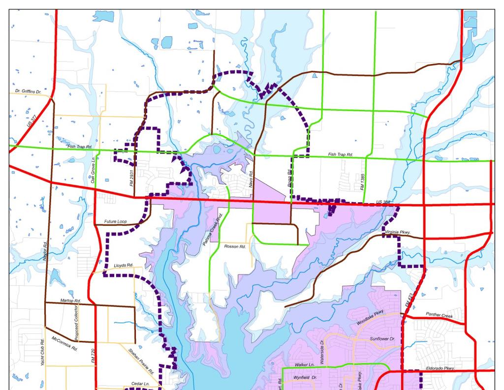
2 Denton Frisco Little Elm Lewisville Legacy Southlake Grapevine Addison DENTON COUNTY & LEWISVILLE LAKE
3

4
5 MATCHING FUNDS DENTON COUNTY BOND PASSED NOVEMBER 4 th WITH MATCHING FUNDS ON SEVEN LITTLE ELM PROJECTS Eldorado Parkway Streetscape Main Street & Lakeshore L Drive King Road (West) Witt Road Woodlake Parkway Connector Lobo Lane Witt Road Bridge e (20% Local Match) U.S. 380 Corridor Study REGIONAL TOLL REVUNE (RTR) FROM SH 121 TOLL USED TO FUND LOCAL PROJECTS. LITTLE ELM S S WITT ROAD BRIDGE WAS SELECTED BY REGIONAL TRANSPORTATION COMMITTEE (RTC)
 $3,000,000 King Road Four-Lane Concrete ($2.8 M Denton Co.) $700,000 Lobo Lane Four-Lane Concrete ($2.4 M TCG & Denton Co.) $1,000,000 Main & Lakeshore Upgrade to Concrete ($1.")
6 Street Projects: Button Street Paving & Drainage Upgrade of Concrete $1,000,000 Clark Street Paving & Drainage Upgrade of Concrete $1,000,000 Eldorado Parkway Streetscape ($3.0 M Denton Co.) $3,000,000 King Road Four-Lane Concrete ($2.8 M Denton Co.) $700,000 Lobo Lane Four-Lane Concrete ($2.4 M TCG & Denton Co.) $1,000,000 Main & Lakeshore Upgrade to Concrete ($1.5 M Denton Co.) $2,500,000 Smotherman Road Reconstruct to Concrete $1,000,000 Witt Woodlake Connector ($0.6 M Denton Co.) $600,000 Witt Road Bridge ($5.565 M RTC/Denton Co.) 0 Town Center Pedestrian Gateway $600,000 Total Bond Need: $11,400,000 Match: $15,865,000 Total Project Costs: $27,265,000
 $1,000,000 Total Projects Costs $1,000,000 Town Bond")
7 Button Street Paving & Drainage From Eldorado Parkway to Main Street (0.6 miles) $1,000,000 Total Projects Costs $1,000,000 Town Bond Need

 PROJECT WOULD IMPROVE")

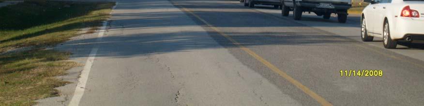
8 Button Street Paving & Drainage From Eldorado Parkway to Main Street (0.6 miles) PROJECT WOULD IMPROVE STREET TO CONCRETE WITH CURBS, SIDEWALK, UNDERGROUND DRAINAGE, AND PEDESTRIAN LIGHTING.
 $1,000,000 Total Projects Costs $1,000,000 Town Bond")
9 Clark Street Paving & Drainage From Eldorado Parkway to Main Street (0.4 miles) $1,000,000 Total Projects Costs $1,000,000 Town Bond Need


10 Clark Street Paving & Drainage From Eldorado Parkway to Main Street (0.4 miles) PROJECT WOULD IMPROVE STREET TO CONCRETE WITH CURBS, SIDEWALK, UNDERGROUND DRAINAGE, AND PEDESTRIAN LIGHTING.
 $6,000,000 Total Project Costs $3,000,000 Town Bond Need (with $3,000,000 match from Denton")
11 Eldorado Parkway Streetscape From West Town limits to East Town limits along Eldorado Parkway (6.0 miles) $6,000,000 Total Project Costs $3,000,000 Town Bond Need (with $3,000,000 match from Denton County)


12 Eldorado Parkway Streetscape From West Town limits to East Town limits along Eldorado Parkway (6.0 miles) Eldorado Parkway runs directly through the heart of Little Elm. The Town desires to establish a streetscape that will uniquely identify Little Elm through t the incorporation of enhancements, including landscaping and lighting, along the roadway. The Town's intent is to beautify the main east-west transportation corridor through Denton County. The concept plan is in place and several elements have already been b included within TXDOT s s Eldorado Parkway Project.


")

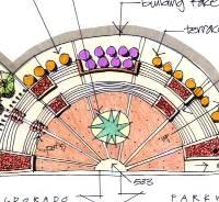
13 Eldorado Parkway Streetscape From West Town limits to East Town limits along Eldorado Parkway (6.0 miles) EXISTING STREETSCAPE
14 Eldorado Parkway Streetscape From West Town limits to East Town limits along Eldorado Parkway (6.0 miles) ENTRY FEATURES
15 Eldorado Parkway Streetscape From West Town limits to East Town limits along Eldorado Parkway (6.0 miles)
16 Eldorado Parkway Streetscape From West Town limits to East Town limits along Eldorado Parkway (6.0 miles) TYPICAL MEDIANS
 $3,500,000 Total Project Costs $700,000 Town Bond Need (with $2,800,000 match from")
17 King Road (West Extension) From Witt Road to Little Elm/Hackberry City Limits (0.75 miles) $3,500,000 Total Project Costs $700,000 Town Bond Need (with $2,800,000 match from Denton County)


18 King Road (West Extension) From Witt Road to Little Elm/Hackberry City Limits (0.75 miles) The Town is currently in the process of constructing King Road from f F.M. 423 to Witt Road. The proposed extension would complete a needed d east- west thoroughfare. Project would include two concrete lanes of an ultimate four lane section (other half is in the City of Frisco) with other roadway enhancements along King Road.
19 King Road (West Extension) From Witt Road to Little Elm/Hackberry City Limits (0.75 miles) TYPICAL SECTION
 $3,400,000 Total Projects $1,000,000 Town Bond Need (with $700,000 Texas Capital Grant for RTI")
20 Lobo Lane Reconstruction From Eldorado Parkway to Cottonwood Park (1.0 miles) $3,400,000 Total Projects $1,000,000 Town Bond Need (with $700,000 Texas Capital Grant for RTI Expansion & $1,700,000 match from Denton County)
 Construction of underground storm water system to improve drainage and construction of a four-lane concrete street that will")

21 Lobo Lane Reconstruction From Eldorado Parkway to Cottonwood Park (1.0 miles) Construction of underground storm water system to improve drainage and construction of a four-lane concrete street that will transition to a two-lane concrete street after the LEISD schools and include sidewalk improvements and trail to connect Cottonwood Park to Little Elm Park along the e west side, street lighting, and landscape. Improvements will provide increased capacity for existing schools, marina development, Cottonwood Sports Complex, and Industrial development.

 WOULD FUND NECESSARY")
22 Lobo Lane Reconstruction From Eldorado Parkway to Cottonwood Park (1.0 miles) WOULD FUND NECESSARY DRAINAGE IMPROVEMENTS


23 Lobo Lane Reconstruction From Eldorado Parkway to Cottonwood Park (1.0 miles) PROPOSED FOUR LANES TO IMPROVE TRAFFIC
 $1,000,000 Total Project Costs $1,000,000 Town")
24 Smotherman Road From F.M. 423 to Town Limits (0.4 miles) $1,000,000 Total Project Costs $1,000,000 Town Bond Need


25 Smotherman Road From F.M. 423 to Town Limits (0.4 miles) PROJECT WOULD IMPROVE STREET TO CONCRETE WITH CURBS, SIDEWALK, UNDERGROUND DRAINAGE, AND PEDESTRIAN LIGHTING. STREET ACTS AS A COLLECTOR BETWEEN LITTLE ELM AND FRISCO
 $1,200,000 Total Project Costs $600,000 Town Bond Need (with $600,000 match from Denton")
26 Witt Road & Woodlake Connector From Woodlake Parkway to the intersection of Witt Road (0.7 miles) $1,200,000 Total Project Costs $600,000 Town Bond Need (with $600,000 match from Denton County)
 Construction of a road to connect and align Witt Road with Woodlake Parkway at the signalized")

27 Witt Road & Woodlake Connector From Woodlake Parkway to the intersection of Witt Road (0.7 miles) Construction of a road to connect and align Witt Road with Woodlake Parkway at the signalized intersection of Eldorado Parkway. This project will provide access to Eldorado Parkway for the Villages of Woodlake and allow for traffic t to use Witt Road. This is necessary for left turn access to Eldorado Parkway y from subdivision.
28 Witt Road & Woodlake Connector From Woodlake Parkway to the intersection of Witt Road (0.7 miles)
 Good News!")
29 Witt Road Bridge From Witt Road two lane section and bridge at Cottonwood Creek (0.25( miles) Good News! $0 (with $5,565,000 total match from 80% RTR/RTC & 20% Denton County)


30 Witt Road Bridge From Witt Road two lane section and bridge at Cottonwood Creek (0.25( miles) This bridge is located on the only north-south thoroughfare through Little Elm. It has an extremely low elevation and has been closed due to high water fourteen times in the past fifteen months for a total tal of forty-five five days. This roadway connects F.M. 423 to Eldorado Parkway and is instrumental to local mobility and emergency response time.

31 Witt Road Bridge From Witt Road two lane section and bridge at Cottonwood Creek (0.25( miles) BRIDGE FLOODS WITH FIVE YEAR RAINFALL EVENT
 $4,000,000 Total Project Costs $2,500,000 Town Bond Need (with $1,500,000 match from Denton")
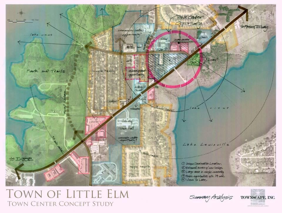
32 Main Street & Lakeshore Drive East Park Street to Eldorado Parkway; Main Street to Meadow Bend (0.5 miles) $4,000,000 Total Project Costs $2,500,000 Town Bond Need (with $1,500,000 match from Denton County)
33
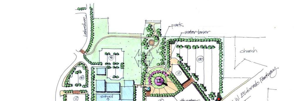
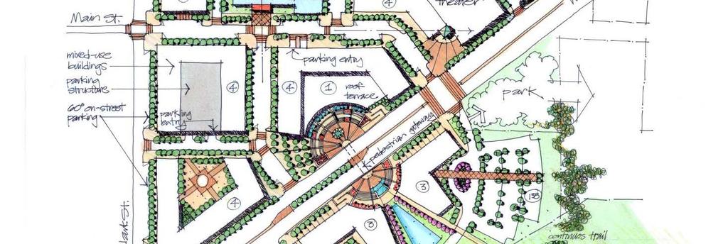
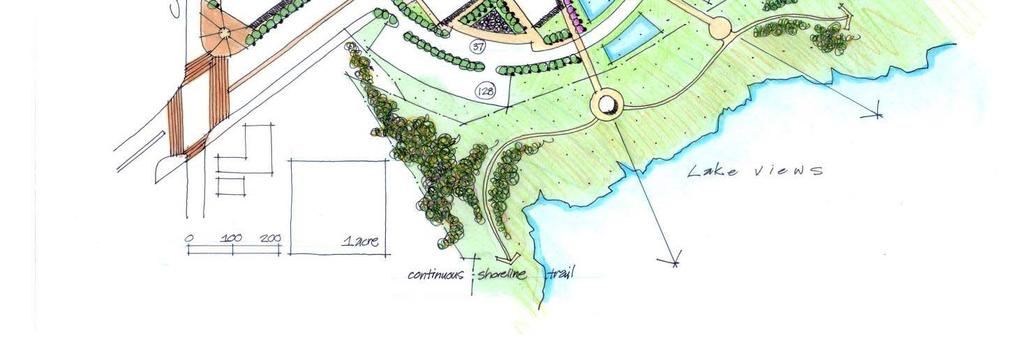
 Main Street is in the heart of the proposed Town Center Development ent Project.")

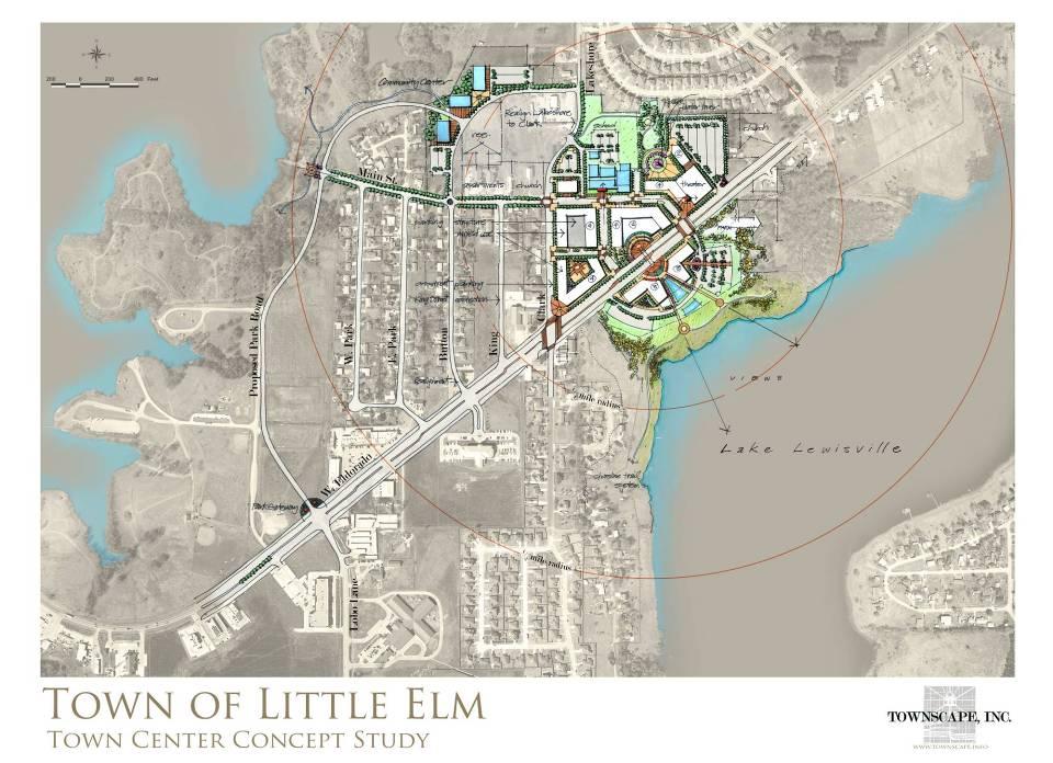
34 Main Street & Lakeshore Drive East Park Street to Eldorado Parkway; Main Street to Meadow Bend (0.5 miles) Main Street is in the heart of the proposed Town Center Development ent Project. This project envisions a Main Street that would compliment ment that project with on street parking, utility improvements, lighting ing enhancements, landscape, and sidewalks. Phase One is design and ready to bid for construction as soon as the funding is available.


35 Main Street & Lakeshore Drive East Park Street to Eldorado Parkway; Main Street to Meadow Bend (0.5 miles)
36

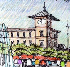
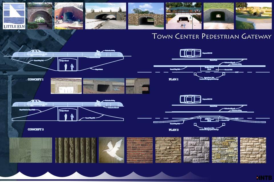
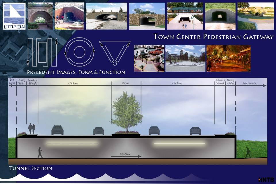
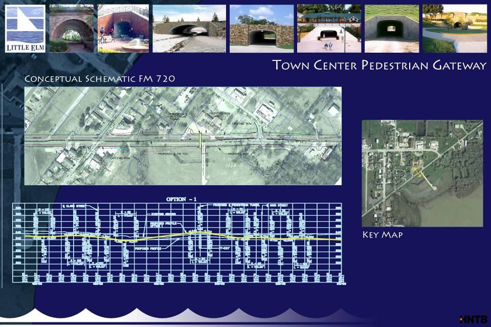
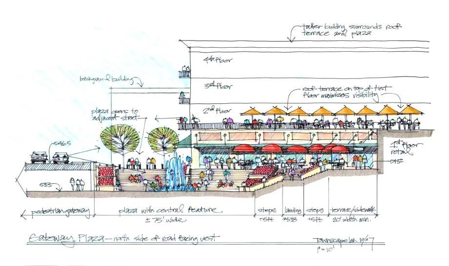
37 Town Center Pedestrian Gateway From Town Center Project $600,000 Total Project Costs $600,000 Town Bond Need
 to place a pedestrian tunnel between en Main")

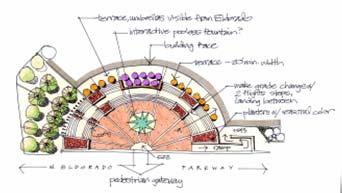
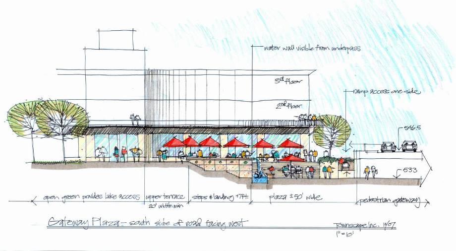
38 Town Center Pedestrian Gateway From Town Center Project The Town has been working with TXDOT and the Town's Economic Development Corporation (EDC) to place a pedestrian tunnel between en Main Street and Clark Street to provide pedestrian access to both h sides of the potential Town Center Project. The concept envisions open plaza's on both sides of the development for public gatherings.
39
40
41
42
43
44
45
46 QUESTIONS? COMMENTS? DOUG PEACH DIRECTOR OF PUBLIC WORKS (214) JASON W. LAUMER, P.E. TOWN ENGINEER (214)
TIRZ 17/Redevelopment Authority Capital Improvements Plan Projects
 Gessner Widening: T-1701 What: Widen the road from a six-lane divided boulevard to an eight-lane divided boulevard street section, increase turn lanes, update traffic signal system, improve drainage by
SH 199 Corridor Master Plan. Community Meeting No. 2 May 31, 2017
 Community Meeting No. 2 May 31, 2017 Transportation Projects On or Near SH 199 SH 199 from 0.3 miles south of FM 1886 to south end of Lake Worth bridge Construct freeway mainlanes and frontage roads 10-Year
Memorandum CITY OF DALLAS. Riverfront Boulevard Design From Continental Avenue to Cadiz Street
 Memorandum DATE November 10, 2011 CITY OF DALLAS TO Trinity River Corridor Project Committee Members: Vonciel Jones Hill (Chair) Linda Koop (Vice Chair), Monica Alonzo, Scott Griggs, Angela Hunt, and Delia
2017 General Obligation Bond
 2017 General Obligation Bond Presentation of Public and Council Projects to the Transportation & Mobility Stakeholder Committee April 13, 2017 Agenda Deferred Maintenance Project Development Process Projects
Sustainable Development Call for Projects Western Infrastructure Project Submissions
 2009-2010 Sustainable Development Call for Projects Western Infrastructure Project Submissions January 20, 2010 2009-2010 SDCFP Summary of Infrastructure Funding Infrastructure Projects Number of Projects
Project Goal. RRRC Living Towns Planning Workshp. Town of Halifax Revitalization Project. Dynamic Planning & Management Duo: July 12, 2006
 Project Goal Town of Halifax Revitalization Project RRRC Living Towns Planning Workshp July 12, 2006 Town of Halifax Halifax County *** Revitalization Project Goal*** To create Economic Opportunity and
PROPOSED REDEVELOPMENT OF THE GLEN ABBEY GOLF CLUB. STREETSCAPE DESIGN STUDY (excerpt from the Urban Design Brief) TOWN OF OAKVILLE.
 TOWN OF OAKVILLE.") PROPOSED REDEVELOPMENT OF THE GLEN ABBEY GOLF CLUB STREETSCAPE DESIGN STUDY (excerpt from the Urban Design Brief) TOWN OF OAKVILLE OCTOBER, 2016 for 2.4.2 STREETS Streets are the single largest component
PROPOSED REDEVELOPMENT OF THE GLEN ABBEY GOLF CLUB STREETSCAPE DESIGN STUDY (excerpt from the Urban Design Brief) TOWN OF OAKVILLE OCTOBER, 2016 for 2.4.2 STREETS Streets are the single largest component
2040 Long Range Transportation Plan
 2040 Long Range Transportation Plan Adopted: April 15, 2013 APPENDIX D HIGHWAY NEEDS PLAN PROJECTS FREDERICKSBURG Existing and Committed Projects Fall Hill Avenue/Mary Washington Blvd. (Fredericksburg)
Exhibit A. SH 161 RTC Work Program of New Projects. Collin County
 Exhibit A SH 161 RTC Work Program of New Projects Collin County 0918-24-969 N/A 0918-24-970 N/A 0918-24-973 N/A 2351-01-020 N/A 2679-03-010 N/A On Exchange Parkway from US 75 to Allen Heights On Country
Chapter 2: Preliminary Analysis
 State Highway 5 Corridor Context Sensitive Master Plan ADOPTED June 17, 2014 (Resolution 2014-06-071) Chapter 2: Preliminary Analysis Before looking to the future of the State Highway 5 (SH 5) Corridor,
Town of Yucca Valley Capital Improvement Projects Report July 24, 2014
 Town of Yucca Valley Capital Improvement Projects Report July 24, 2014 SR 62 Traffic and Pedestrian Improvements from Apache Trail to Palm Avenue (PLHD) The project includes construction of curbs, gutters,
Panama City Beach Community Redevelopment Agency Condo Con Property Owner Conference & Expo November 14, 2014
 Panama City Beach Community Redevelopment Agency Condo Con Property Owner Conference & Expo November 14, 2014 Front Beach Road CRA On November 30, 2000, the City created the Panama City Beach Community
Welcome! to Keller Town Hall
 Welcome! to Keller Town Hall Keller Town Center Planning a New Downtown What is Keller Town Center? A new, growing downtown district planned as an urban village A combination of retail and office spaces,
Potential Green Infrastructure Strategies May 6, 2015 Workshop
 Potential Green Infrastructure Strategies May 6, 2015 Workshop Background The City of Cortland is developing the Tioughnioga Urban Headwaters Green Infrastructure Action Plan with funding from the National
Date: April 10, 2017 City Council Work Session April 24, 2017: Status Report on the Comprehensive Plan Update and Transportation Master Plan
 AGENDA REPORT To: From: By: Honorable Mayor and City Council Members Warren Hutmacher, City Manager Sharon Ebert, Director Community Development Date: April 10, 2017 Agenda: City Council Work Session April
Executive Summary. NY 7 / NY 2 Corridor
 Executive Summary NY 7 / NY 2 Corridor Transportation and Land Use Study December 2005 Prepared for: Town of Colonie Capital District Transportation Committee Prepared by: Introduction: Land use decisions
BROOKHILL NEIGHBORHOOD MODEL ZONING MAP AMENDMENT PREFACE TO APPLICATION
 BROOKHILL NEIGHBORHOOD MODEL ZONING MAP AMENDMENT PREFACE TO APPLICATION June 15, 2015 Revised: August 1, 2016 I. VISION Brookhill is a proposed community based upon the principles of Albemarle County
Table of Contents. Elm Avenue Improvement Plan City of Waco, Texas. Introduction 1. Existing Context 1 Figure 1 2.
 Table of Contents Introduction 1 Existing Context 1 Figure 1 2 Plan Guidelines 3 Future Urban Form 4 The West-End 4 Main Street 6 The East-End 7 Figure 2 9 Public Improvement Recommendations 7 General
Implementation Guide Comprehensive Plan City of Allen
 Implementation Guide 2030 Comprehensive Plan City of Allen DRAFT 2015 Implementation Guide Allen 2030 Comprehensive Plan INTRODUCTION The Comprehensive Plan serves as a guide for the growth and development
Municipality of Anchorage. Community Council Survey Capital Projects Needs Ranking Survey (ALPHABETICAL) Airport Heights
 Airport Heights") ANCHORAGE PARKS & RECREATION Nichols Park Design and improve neighborhood park 2008 Challenge Grant applicant. 2008 $500K State Grant for Neighborhood Parks. Tikishla Park Lighting, paved parking, hockey
ANCHORAGE PARKS & RECREATION Nichols Park Design and improve neighborhood park 2008 Challenge Grant applicant. 2008 $500K State Grant for Neighborhood Parks. Tikishla Park Lighting, paved parking, hockey
2.0 AREA PLANS. Lakeside Business District. Lakeside Business District Land Use Categories:
 Lakeside Business District Lakeside Business District Land Use Categories: Campus Commercial Campus Commercial means a mixture of uses which includes corporate offices, office parks, hotels, commercial,
Cottage Grove Road Reconstruction. City of Madison Engineering
 Public Informational Meeting Cottage Grove Road Reconstruction October 8, 2015 Presentation Outline Introduction Project Purpose & Need Proposed Design Overview Environmental Concerns Pedestrian Needs
Scope of Services. River Oaks Boulevard (SH 183) Corridor Master Plan
 Corridor Master Plan") Scope of Services River Oaks Boulevard (SH 183) Corridor Master Plan PROJECT AREA The project area consists of the River Oaks Boulevard (SH 183) corridor bounded by SH 199 at the northern end and the Trinity
Scope of Services River Oaks Boulevard (SH 183) Corridor Master Plan PROJECT AREA The project area consists of the River Oaks Boulevard (SH 183) corridor bounded by SH 199 at the northern end and the Trinity
SECTION TWO: Urban Design Concepts
 SECTION TWO: Urban Design Concepts The Gardnerville Plan for Prosperity shapes economic opportunities presented by regional growth. The Urban Design Concepts provide policies and concepts for land use,
Pine Island Road Corridor Master Plan
 RECOMMENDED DEVELOPMENT PLAN Figure 9: Del Prado Village District Conceptual Framework The Conceptual Framework (Figure 8) for development of the Pine Island Corridor is to encourage mixed-use development
A larger version of this map is located on the last page of this PDF.
 MAP Committee Input McLoughlin Area Draft Vision Map A larger version of this map is located on the last page of this PDF. 1. The map above is intended to portray a vision for the McLoughlin area. It highlights
New Braunfels Growth & Development. Garry Ford, Jr., P.E., PTOE City Engineer City of New Braunfels
 New Braunfels Growth & Development Garry Ford, Jr., P.E., PTOE City Engineer City of New Braunfels Overview Growth Development Transportation Water Challenges Addressing the Growth, Development and Challenges
Capital Projects in and near Odenton Town Center
 Capital Projects in and near Odenton Town Center Map ID Anne Arundel County Department of Public Works This project provides for the design, right of way acquisition, and construction of approximately
Capital Projects impacting Odenton Town Center
 Capital Projects impacting Odenton Town Center 1 2 E549700 W801600/ W801602 Anne Arundel County Department of Public Works Manor View Elementary School Transmission Main - MD 32 @ Meade Phase 2 $34,399,000
2018 Primary Road Capital Improvement Plan (CIP) Projects Preservation / Structural Improvement, Non-motorized and Engineering Design Projects
 Projects Preservation / Structural Improvement, Non-motorized and Engineering Design Projects") 2018 Primary Road Capital Improvement Plan (CIP) Projects Preservation / Structural Improvement, Non-motorized and Engineering Design Projects Preservation / Structural Improvement Projects in 2018 Ravine
2018 Primary Road Capital Improvement Plan (CIP) Projects Preservation / Structural Improvement, Non-motorized and Engineering Design Projects Preservation / Structural Improvement Projects in 2018 Ravine
South Davis County COMMUNITY SPOTLIGHT
 South Davis County COMMUNITY SPOTLIGHT Davis/SLC Community Connector Bus Rapid Transit line connecting SLC & Davis County RTP Phase 1 Project Generate 3,100 average weekday riders Relieve congestion on
Welcome. Community Consultation Meeting November 28, Review and discuss the Bathurst Quay Neighbourhood Plan Framework
 Welcome Community Consultation Meeting November 28, 2016 Why Are We Here Today? Review and discuss the Bathurst Quay Neighbourhood Plan Framework Review and discuss an Action Plan for Implementation Next
City of Dallas Complete Streets Program. SAME Infrastructure Forum February 2, 2018
 City of Dallas Complete Streets Program SAME Infrastructure Forum February 2, 2018 Complete Streets Design Manual Adopted by City Council January 27, 2016 JANUARY 27, 2016 2 What are Complete Streets?
UNIVERSITY CITY AREA PLAN. Volume Two: Implementation Plan
 UNIVERSITY CITY AREA PLAN Volume Two: Implementation Plan Transforming the University City MSD into the vibrant, people-oriented place envisioned in the University City Plan will occur incrementally through
BENJAMIN BANNEKER PARK FRAMEWORK PLAN (PLAN ADOPTION)
") BENJAMIN BANNEKER PARK FRAMEWORK PLAN (PLAN ADOPTION) COUNTY BOARD MEETING DECEMBER 16, 2017 County Board Consideration: Adopt the Benjamin Banneker Park Framework Plan and Design Guidelines Framework
BENJAMIN BANNEKER PARK FRAMEWORK PLAN (PLAN ADOPTION) COUNTY BOARD MEETING DECEMBER 16, 2017 County Board Consideration: Adopt the Benjamin Banneker Park Framework Plan and Design Guidelines Framework
FY 2005 TRANSPORTATION CAPITAL PROGRAM
 Camden County Civic Center Access Study, Pennsauken 03340 This project will address operational and access improvements on Routes 30, 73 and 90 related to the Crossroads redevelopment project around the
Location. Served. Category. Units Start Year. Previous Appropriations
 20142018 CAPITAL IMPROVEMENT PLAN ($ Thouss) CITY OF HOUSTON STREET & TRAFFIC CONTROL Project: TC Jester: Washington to I 10 N100002 Paving Drainage Project Description Project provides for the design
Development Guidelines - Florin-Vineyard Community Plan Administrative Draft
 TABLE OF CONTENTS 1.0 INTRODUCTION... 1-1 1.1 Purpose and Intent... 1-1 1.2 Setting... 1-1 1.3 Land Use Summary... 1-3 2.0 RESIDENTIAL LAND USES... 2-1 2.1 Residential Densities... 2-1 2.2 Existing Neighborhood
2017 Investment in Infrastructure Expo February 28, 2017 Jason Jonas, P.E. Public Works Director
 2017 Investment in Infrastructure Expo February 28, 2017 Jason Jonas, P.E. Public Works Director 1 Jefferson County, Missouri Road and Bridge Sales Tax: Jefferson County has a one-half cent sales tax that
Regional Mobility & the US 380 Bypass Concept. Informational Meeting February 9, 2017
 Regional Mobility & the US 380 Bypass Concept Informational Meeting February 9, 2017 Purpose and Agenda Purpose: Regional Mobility Issues, Priorities, and Pressures US 380 as a Limited Access Facility
Capital Improvements Program FY18-FY22 Bryan City Council Workshop. May 16, 2017
 Capital Improvements Program FY18-FY22 Bryan City Council Workshop May 16, 2017 1 Presentation Today Proposed FY18-FY22 Projects Questions 2 FY18 CIP FY18 Debt Issuance = $9,663,000 + $2,470,000 = $12,133,000
Index to Projects by Project Name
 Index to Projects by Project Name 2062 1701 & 1711 Concord Avenue Purchase and Demolition of Structures 85 1279 1024 UF-802 UF-803 Affordable Housing 77 Annual CIP/TIP Management Program 105 Arnold Industrial
FY STATEWIDE TRANSPORTATION IMPROVEMENT PROGRAM New Jersey Department of Transportation Projects
 ROUTE/ Project ID No. TIP No. Burlington County Computerized Signal Control, IV D9911 D9911 This ITS project will be a traffic responsive signal system, consisting of 24 intersections--9 on CR 607, 4 on
M E M O R A N D U M July 27, 2018
 M E M O R A N D U M July 27, 2018 To: Southlake 2035 Corridor Planning Committee From: Kenneth Baker, Sr. Director of Planning and Development Services Subject: Item #6 First National Bank Purpose Review,
Design Guidelines for the Route 30 Corridor Master Plan: Subdivision and Land Development Elements
 Design Guidelines for the Route 30 Corridor Master Plan: Subdivision and Land Development Elements East Whiteland Township- Chester County, PA Prepared by: Draft: May 7, 2018 Design Guidelines for the
INFRASTRUCTURE EXISTING INFRASTRUCTURE A. Circulation B. Signals C. Drainage D. Utilities
 7.01. EXISTING INFRASTRUCTURE A. Circulation B. Signals C. Drainage D. Utilities 7.02. PROPOSED INFRASTRUCTURE A. Overall Concept B. Circulation C. Signals D. Drainage 7.03. INFRASTRUCTURE MAP A. Key Infrastructure
Section 1. Executive Summary
 Executive Summary (This page left blank intentionally) Executive Summary Background Economic growth in southern Leavenworth County over the past decade has been strong. As both the number of business and
This Review Is Divided Into Two Phases:
 Semiahmoo Town Centre Review The purpose of this review: To review the Semiahmoo Town Centre Concept Plan, originally approved in 1993, to ensure that this centre will continue to serve the needs of South
III - design standards
 III - design standards The Circulation Classification and Character section of the Design Standards chapter prescribes the types of circulation routes, the location of the circulation routes, the connections
Borderland Expressway Coalition Status Report Camino Real RMA Board Meeting. El Paso, TX April 11, 2018
 Borderland Expressway Coalition Status Report Camino Real RMA Board Meeting El Paso, TX April 11, 2018 Coalition Key Stakeholders Texas Department of Transportation New Mexico Department of Transportation
Main Street Reconstruction From Ninth Line to Stouffer Street. Town of Whitchurch-Stouffville. Public Information Centre
 Main Street Reconstruction From Ninth Line to Stouffer Street Town of Whitchurch-Stouffville Public Information Centre November 23, 2016 4:30 to 6:00 pm & 7:00 to 8:00 pm 6240 Main Street, Stouffville
JOB CREATION PROJECTS
 SPRINGDALE INFRASTRUCTURE DEVELOPMENT PLAN JOB CREATION PROJECTS The following pages provide a narrative description, preliminary street alignment and a preliminary construction cost estimate for each
State Highway 5 Corridor Context Sensitive Master Plan
 ADOPTED June 17, 2014 (Resolution 2014-06-071) Travel Lane Travel Lane 11 11 Median 16 Min State Highway 5 Corridor Context Sensitive Master Plan 1 Prepared for: Prepared by: State Highway 5 Corridor
Farmersville Parkway Phase III
 Farmersville Parkway Phase III Application to the TIGER VI Discretionary Grant Program April 2014 Submitted By: City of Farmersville 205 South Main Street Farmersville, Texas 75442 972-782-6151 TABLE OF
Plan Policies. Introduction
 Plan Policies Introduction The purpose of the Plan Policies section is to identify the various Governing Body and Planning Commission land use related policy resolutions for use in evaluating development
Index to Projects by Project Name
 Index to Projects by Project Name Project # PROJECT NAME PAGE 2134 2119 PR-1109 Clayton Road (Market Street to Oakland Avenue) Sidewalk Repair 911 System Replacement and Dispatch Room Remodel ADA Barrier
AGENDA ACTION ITEMS INFORMATION ITEMS
 NOACA Bicycle and Pedestrian Advisory Council Meeting Friday, March 21 st, 2014 10:30 a.m. NOACA Office 1299 Superior Avenue Cleveland, Ohio 44114 Phone: (216) 241-2414; website: www.noaca.org AGENDA ACTION
Project Team and Committee
 Project Team and Committee Village of Northfield (lead agency) staff: Stacy Sigman Michael Nystrand Cook County (partner agency) staff Tara Fifer Tara Orbon Consultant Engineering staff: Jarrod Cebulski
Public input has been an important part of the plan development process.
 Lakewood s Comprehensive Plan recognizes that transportation helps shape the community, and that the way the community provides for the safe and efficient movement of people affects the character of the
Hunt Highway CELESTE PEMBERTON, CFM, CPM PINAL COUNTY CARLOS SANCHEZ SORIA, PE T.Y. LIN INTERNATIONAL
 Hunt Highway CELESTE PEMBERTON, CFM, CPM PINAL COUNTY CARLOS SANCHEZ SORIA, PE T.Y. LIN INTERNATIONAL Agenda Design Concept Report Phase 1 Phase 2 Phase 3 Phase 4 Phase 5 Questions Design Concept Report
Eglinton West LRT Update
 Eglinton West LRT Update Community Consultation Update May 16, 2016 Background Rapid transit along Eglinton Ave between Kennedy Station and Pearson Airport was included in the Metrolinx Regional Transportation
Welcome to the. Open House
 Welcome to the 5th Street to Kinsman Road Open House November 14 5:30 7:00 p.m. Please sign in Project Overview In December 2016, City Council adopted SW 5th Street as the preferred alignment to connect
Fall 2017 Construction Update
 Fall 2017 Construction Update Ward 4 Southeast Engineering Department Riverwalk Red Multi-Use Trail Bridge Rehabilitation The Riverwalk Red Multi Use Trail Bridge was awarded to Cramer and Associates,
Pedestrian and Bike Bridge LOGO
 6.2.2 Pedestrian and Bike Bridge The proposed pedestrian and bike crossing re-envisions the existing bridge at Pismo Creek on Cypress Street. The bridge is currently underutilized by vehicular through
Olde Towne Vision Plan
 Olde Towne Vision Plan Introduction In 2016, the City of Bellevue will complete its move of City offices from Olde Towne Bellevue to its new municipal complex on Wall Street. The City intends to sell its
State Highway 121 Southwest Parkway. Fort Worth s Transportation Success Story in Design and Cooperation
 State Highway 121 Southwest Parkway Fort Worth s Transportation Success Story in Design and Cooperation Greater Fort Worth Association of Realtors October 24, 2007 Presented by: Dan Lamers, P.E. North
PRELIMINARY PLAT DESIGN REQUIREMENTS Updated 4/8/2016
 PRELIMINARY PLAT DESIGN REQUIREMENTS Updated 4/8/2016 The following items are required for the preliminary plat. Numbers correspond with those on the example preliminary plat. RENO COUNTY SUBDIVISION REQUIREMENTS
3. VISION AND GOALS. Vision Statement. Goals, Objectives and Policies
 Vision Statement Queen Creek s interconnected network of parks, trails, open spaces and recreation opportunities provide safe and diverse activities and programs that sustain its unique, small town, equestrian
Introduction Issues Affecting Corinth Regional Initiatives Community Issues Thoroughfare Planning...
 ontents Introduction... 3-1 Issues Affecting orinth... 3-2 Regional Initiatives... 3-2 ommunity Issues... 3-9 Thoroughfare Planning... 3-14 Functional Street lassifications... 3-14 ontext-sensitive Design...
124 Subarea Visions. Vision Plan. A. Nelessen Associates, INC I Visioning I Planning I Urban Design
 Subareas 124 Subarea Visions The next seven sections describe specific recommendations tailored to each subarea. Each subarea is discussed separately except for certain aspects of 95th Street and Antioch
CITY OF BOYNTON BEACH SE 1 ST STREET COMPLETE STREETS IMPROVEMENTS
 CITY OF BOYNTON BEACH SE 1 ST STREET COMPLETE STREETS IMPROVEMENTS N Project Location -Town Square -Villages at Ocean SE 1st St, between E Woolbright Rd and SE 2nd Ave Project Location -Boynton One -Publix
4.500 Preston Road Overlay District
 Section 4.500 Preston Road Overlay District 2004 Zoning Ordinance 4.500 Preston Road Overlay District (ZC 98-29; Ordinance No. 98-9-12) 4.501 Purpose To provide appropriate design standards for the use
City of Kearney Capital Improvement Update October 1, TH STREET AND 17TH AVENUE IMPROVEMENTS
 56TH STREET AND 17TH AVENUE IMPROVEMENTS FUNDING: Bonded ESTIMATED COST: $3,885,000 COMPLETION DATE: Fall 2018 SCOPE OF PROJECT: Widening of 56th Street from 6th Avenue to 19th Avenue, and widening 17th
THREE-YEAR CAPITAL IMPROVEMENT PLAN FY
 THREE-YEAR CAPITAL IMPROVEMENT PLAN FY2016 2018 Annual CIP Development Process Public Works & Engineering Divisions Prepare List of Capital Needs and Recommended Deferred Maintenance Public Works & Engineering
INTRODUCTION EXISTING CONDITIONS
 INTRODUCTION The Pedestrian Mobility Study and Plan is a Transportation Planning effort to identify Safe Mobility Alternatives for Pedestrian and Bicycle traffic within the City of Port Aransas. This plan
Prince William Street Project (Grant Avenue to Wellington Road)
") Prince William Street Project (Grant Avenue to Wellington Road) 1 Goals Improve pedestrian and bike traffic safety Improve street drainage with curb & gutter Upsize water mains Enhance overall street appearance
Prince William Street Project (Grant Avenue to Wellington Road) 1 Goals Improve pedestrian and bike traffic safety Improve street drainage with curb & gutter Upsize water mains Enhance overall street appearance
WELCOME! 8 8:30 6: TH STREET IMPROVEMENTS. Open House. Presentation & Q&A
 WELCOME! 168 TH STREET IMPROVEMENTS 6:30 Open House 7 8 Presentation & Q&A 8 8:30 Open House WELCOME Todd Pfitzer City of Omaha Engineer Bob Stubbe City of Omaha Public Works Director Jon Meyer Project
TOWN OF PALM BEACH FOR IMMEDIATE RELEASE. Patricia Strayer, P.E., Town Engineer Phone: ,
 TOWN OF PALM BEACH DATE: October 19, 2017 FOR IMMEDIATE RELEASE MEDIA CONTACT: Patricia Strayer, P.E., Town Engineer Phone: 561-838-5440, Email: pstrayer@townofpalmbeach.com Construction and Traffic Highlights
Southern Gateway Project and Public Green
 Southern Gateway Project and Public Green Transportation and Trinity River Project Committee May 23, 2016 Purpose of Presentation Provide the history and an overview of the Southern Gateway Project (SGP)
PART 1: PROJECT SUMMARY. Proposed Land Use: 120 single-family lots. The application is Attachment A. The site plan is Attachment B.
 PART 1: PROJECT SUMMARY Applicant: JBH Development, LLC and Hopper Communities, INC Project Size: +/- 80.48 acres Parcel Number: 01513107, 01513108, 01513109, 01513113, 01513120, 01513121, 01513122, 01513124,
The Illinois Department of Transportation and Lake County Division of Transportation. Route 173, including the Millburn Bypass
 The Illinois Department of Transportation and Lake County Division of Transportation welcome you to this Public Hearing for U.S. Route 45 from Illinois Route 132 to Illinois Route 173, including the Millburn
Somers Point Master Plan
 Somers Point Master Plan Progress Report and Public Meeting August 20, 2014 Master Plan Reexamination Municipal Land Use Law require that all municipalities reexamine their master plan every ten years.
Abbott Loop. Community Council Survey Capital Projects Needs Ranking Survey. Comm Council Priority Rank. Rank # ABBOTT LOOP COMMUNITY PARK
 Municipality of Anchorage Community Council Survey ABBOTT LOOP COMMUNITY PARK This state funding request would be used to implement the remaining elements of the Community Park Master Plan Vision including
BUILDING SCALE AND SETBACKS 5 ELEMENTS:... 5 FAÇADES (COMMERCIAL/RESIDENTIAL) 5
 5") VISION STATEMENT 3 UTILIZATION OF THE GUIDELINES 3 IMPLEMENTATION 3 PROCEDURES FOR DESIGN REVIEW 3 LAND USE AND ZONING 4 LAND USE 4 ELEMENTS:... 4 ZONING 4 ELEMENTS:... 4 BUILDING SCALE AND SETBACKS 5
VISION STATEMENT 3 UTILIZATION OF THE GUIDELINES 3 IMPLEMENTATION 3 PROCEDURES FOR DESIGN REVIEW 3 LAND USE AND ZONING 4 LAND USE 4 ELEMENTS:... 4 ZONING 4 ELEMENTS:... 4 BUILDING SCALE AND SETBACKS 5
Community Engagement Committee Meeting #1 December 10, :30pm-8:30pm
 Community Engagement Committee Meeting #1 December 10, 2014 6:30pm-8:30pm Welcome and Introductions Dana Murdoch Minneapolis Park and Recreation Board Project Manager Ryan French Walker Art Center Director
Capital Improvement Program. Development Services Staff Recommended Projects
 2014-2019 Capital Improvement Program Development Services Staff Recommended Projects Ongoing Capital Improvement Ellsworth Road Ryan to Germann Roads $3.5 M Germann Rd Ryan Rd Half-street improvements
Constructing PCCP Under High Traffic Volume
 Constructing PCCP Under High Traffic Volume THE LANE CONSTRUCTION CORPORATION Jim Seybert Casey Hurley PE, PLS November 18, 2016 Agenda Lane Experience Challenges Access Design Elements Staging of Construction
DRAFT ROOSEVELT ROAD. District Recommendations. Figure 5.23 The Roosevelt Road Corridor
 CHAPTER 5 Figure 5.23 The Road Corridor Road will develop as a mixed-use corridor, emphasizing regional retail, west of the river and mixed-use development east of the river. KEY RECOMMENDATIONS 1. High
South Yonge Street Corridor
 South Yonge Street Corridor Streetscape Master Plan Study Draft Final Executive Summary Prepared by: January 2012 In Partnership with: Introduction The Future... Yonge Street is at the forefront of York
5-Year Street Reconstruction Plan ( )
") 5-Year Street Reconstruction Plan (2006-2010) City of Delano Wenck File #0564-37 Prepared for: CITY OF DELANO 234 2 nd Street West Delano, MN 55328 Prepared by: WENCK ASSOCIATES, INC. 1800 Pioneer Creek
5-Year Street Reconstruction Plan (2006-2010) City of Delano Wenck File #0564-37 Prepared for: CITY OF DELANO 234 2 nd Street West Delano, MN 55328 Prepared by: WENCK ASSOCIATES, INC. 1800 Pioneer Creek
FROM DUPONT CIRCLE NORTH TO CALIFORNIA STREET, NW. Welcome!
 FROM DUPONT CIRCLE NORTH TO CALIFORNIA STREET, NW Welcome! Meeting Agenda 6:00 PM Open House 6:30 PM Presentation 7:00 PM Open House / Q&A at the Boards Project Design Team Connecticut Avenue, NW Project
Billing Code: DEPARTMENT OF HOUSING AND URBAN DEVELOPMENT [Docket No. FR-6072-N-01]
![Billing Code: DEPARTMENT OF HOUSING AND URBAN DEVELOPMENT [Docket No. FR-6072-N-01]](/thumbs/91/107309814.jpg "Billing Code: DEPARTMENT OF HOUSING AND URBAN DEVELOPMENT [Docket No. FR-6072-N-01]") This document is scheduled to be published in the Federal Register on 12/18/2017 and available online at https://federalregister.gov/d/2017-27194, and on FDsys.gov Billing Code: 4210-67 DEPARTMENT OF HOUSING
This document is scheduled to be published in the Federal Register on 12/18/2017 and available online at https://federalregister.gov/d/2017-27194, and on FDsys.gov Billing Code: 4210-67 DEPARTMENT OF HOUSING
Asbury Chapel Subdivision Sketch Plan
 Asbury Chapel Subdivision Sketch Plan PART 1: PROJECT SUMMARY Applicant: NVR Inc. Project Size: +/- 76.13 acres Parcel Numbers: 02101112,02116101,02116112, 02116113 Current Zoning: Transitional Residential
The following principles guide the development of goals and strategies to protect and promote these amenities:
 OPEN SPACE/PARKS/TRAILS/RECREATION GOALS/STRATEGIES Cherry Hills Village is a living environment that offers low density development, open areas, public scenic vistas, public trails and public parks. This
WURZBACH PARKWAY WURZBACH PARKWAY
 WURZBACH PARKWAY WURZBACH PARKWAY From Lockhill-Selma Rd to NW Military Hwy Open NW Military HouseHwy/Lockhill-Selma Open House Barshop Jewish Community Center December Barshop Jewish 14, 2017 Community
Lambeth Main Street Streetscape Improvements
 Lambeth Main Street Streetscape Improvements Open House October 5th, 2017 Agenda 1. Introduction 2. Project Background 3. Context 4. Project Objectives 5. Design Principles & Approach 6. Streetscape Design
Fifth and Detroit Street Design May 2017 Capital Improvements Committee. DOWNTOWN Street Design
 1 Fifth and Detroit Street Design May 2017 Capital Improvements Committee Agenda 2 Review Street Configuration Prior Meeting Review Outreach Synopsis Functional Street Design Refinements Curb Edge, Turning
TxDOT Experience with Long-Term Private Maintenance Agreements
 TxDOT Experience with Long-Term Private Maintenance Agreements June 2, 2015 Beau B. Buchanan, P.E. Project Manager TxDOT South Central Strategic Projects Office San Antonio, Texas Maintenance Agreements
Secrest Short Cut and Monroe Expressway Small Area Plan AUGUST 29, 2018
 Secrest Short Cut and Monroe Expressway Small Area Plan AUGUST 29, 2018 Background and Process Monroe Expressway will be open by the end of 2018 Union County and Indian Trail identified a need to revisit
Long Branch Sector Plan
 June 2012 Long Branch is one of Montgomery County s most affordable, older communities and has served as a gateway community, especially for newly arriving immigrants, since the 1960s. Many within this