SECTION 4(f) DE MINIMIS DOCUMENTATION
|
|
|
- Kenneth Wilson
- 5 years ago
- Views:
Transcription
 PROPERTY LOCATION Project Limit P-91-084-07 Lake County, Illinois IDOT Division of Highways District One")
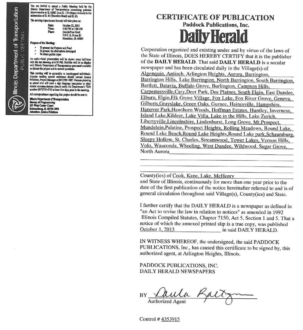
1 SECTION 4(f) DE MINIMIS DOCUMENTATION Illinois Route 60/83 IL 176 to the intersection of IL 60 (Townline Road) Lake County P Mundelein Park and Recreation District Project Limit SECTION 4(f) PROPERTY LOCATION Project Limit P Lake County, Illinois IDOT Division of Highways District One February 2017
2 Table of Contents 1. Project Description Section 4(f) Resource Description of Intended Section 4(f) Resource Use Description of Efforts to Avoid, Minimize, and Mitigate or Enhance the Resource Evidence of Opportunity for Public Review and Comment Evidence of Coordination with Official(s) with Jurisdiction Supporting Documentation... 5 Appendices Appendix A Appendix B Appendix C Appendix D Appendix E Public Information Meetings Official with Jurisdiction Project Drawings Photographs Other Correspondence and Documents Page i
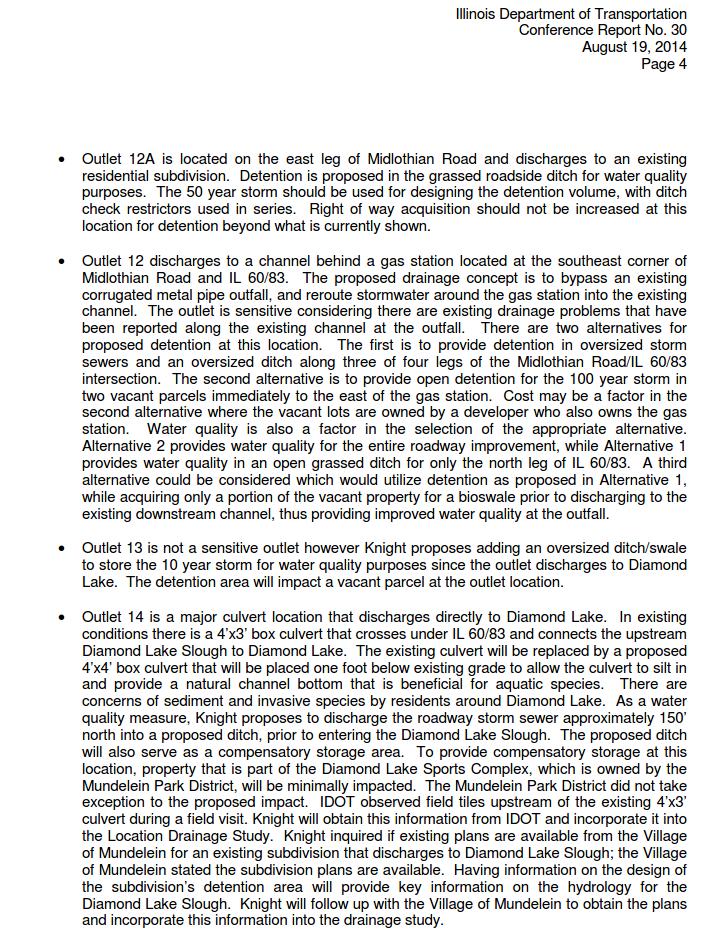
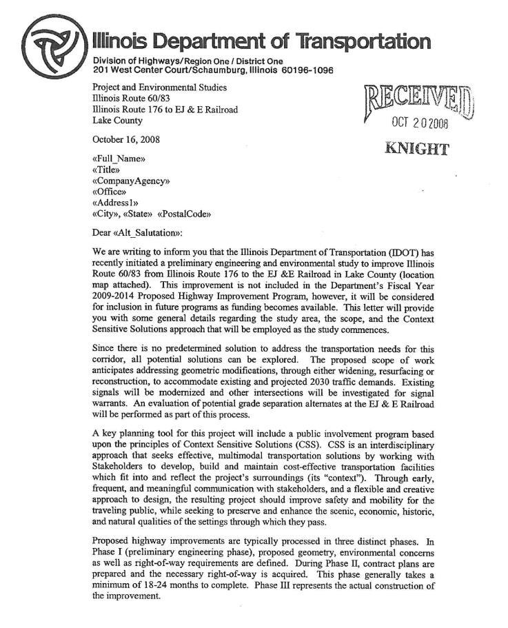
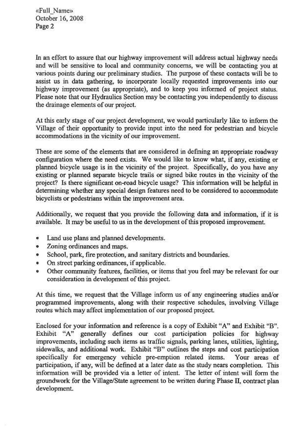
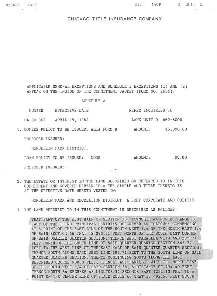
3 1. Project Description a. Project Number: P b. Project Name: IL 60/83 c. Project Location: IL 176 to the Intersection of IL 60 (Townline Road) and IL 83, Lake County, Illinois within the Village of Mundelein, Village of Long Grove, and Lake County d. Project Type: Widening of the existing two-lane rural road to four urban traffic lanes with a median and intersection channelization and signalization at major cross streets. The improvement provides the provisions of a shared-use path as not to preclude the construction of a shared-use path. e. Project Length: The IL 60/83 improvement project is 3.64 miles in length. There is an additional 1.49 miles of cross road improvements. f. NEPA Class of Action: Categorical Exclusion (Federal Approved) g. NEPA Purpose and Need: The purpose of the project is to provide a safe, efficient, widened transportation facility for IL Route 60/83. It will serve through traffic and adjacent land uses for Lake County and the Villages of Mundelein and Long Grove, between IL Route 176 and Townline Road. The proposed improvement will serve to meet the needs of operational deficiencies, traffic safety, system linkage, economic development, and facility degradation. h. Project Status: The Illinois Department of Transportation (Department) is nearing completion of the preliminary engineering and environmental study. The anticipated design approval is June This project is not currently included in the Department s FY Proposed Highway Improvement Program. However, this project will be included in our priorities for future funding consideration among similar improvement needs throughout the region. 2. Section 4(f) Resources a. Resource Type: Municipal recreation area. b. Resource Name: Page 1 of 5
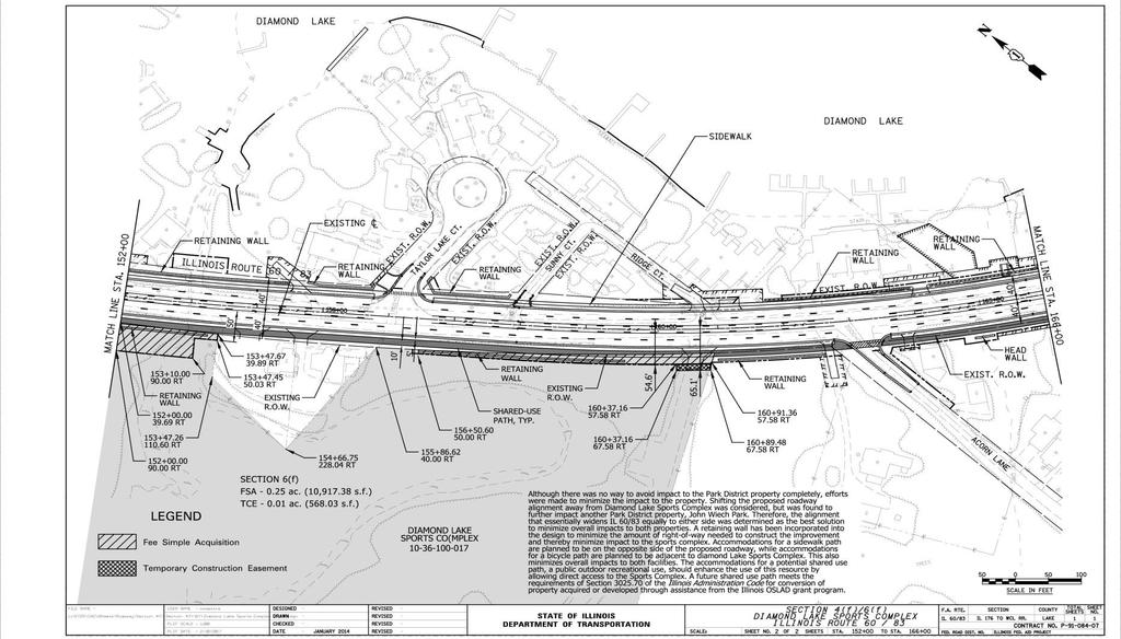
4 c. Official with Jurisdiction (OWJ): Mundelein Park and Recreation District (MPRD) N. Midlothian Road, d. Resource Role/Significance: This recreation area is 43 acres in size. Recreational activities allowed at sports complex are: biking; bocce court; combination sports field for lacrosse, soccer, and junior football; horseshoe pit; ice skating; interpretive and educational trails for hiking; nine-hole disc golf course; shuffleboard; sledding; and snowmobiling. It should be noted that Land and Water Conservation Funds (LWCF) were used to purchase this site and Open Space Lands Acquisition and Development (OSLAD) funds were used to improve this site. See the October 1, in Appendix B for the appropriate correspondence. 3. Description of Intended Section 4(f) Resource Use a. Type and Area of Impacts: The amount of property impacted by this project is approximately 0.32 acres (one parcel) of fee simple acquisition. The amount of property impacted by the project is approximately 0.01 acres (one parcel) of temporary construction easement. The improvement of IL 60/83 will increase the number of traffic lanes from two to four with a two-way left-turn lane, along with provision for construction of a shared-use path. A portion of this roadway widening work requires the placement of fill within the Diamond Lake floodplain. The widening of IL 60/83 and associated drainage and stormwater management requirements for detention and compensatory storage were all considered in determining the acquisition needs in the form of right-of-way and temporary construction easements from. The right-of-way impact to is due to the proposed roadway widening, potential shared-use path, and compensatory storage for the 0 year to 10 year storm profile. The temporary construction easement impact is due to the reconstruction of the Sports Complex driveway in order to meet the proposed vertical grade of IL 60/83. b. Existing Function of the Impacted Area: The impacted area functions as frontage to the main part of the complex and buffers the property from the adjacent roadway and is comprised of open space. Page 2 of 5
5 c. Description of the Relationship of the Area Impacted to the Function and Significance of the Resource: Dense woodlands and wetlands, along with the recreational activities, open space and wooded areas comprise this site. The functionality of the complex would not be affected. 4. Description of Efforts to Avoid, Minimize, and Mitigate or Enhance the Resource a. Although there was no way to avoid impact to the Park District property completely, efforts were made to minimize the impact to the property. Shifting the proposed roadway alignment away from was considered, but was found to further impact another Park District property, John Wiech Park, and would impact two townhome complexes and two single family residences. Eliminating the shared-use path from Kenmore Lane, west of Diamond Lake Sports Complex, to Acorn Lane, east of, was also considered. In doing so, the proposed project would not meet the National and State Complete Streets initiative. Therefore, the alignment that essentially widens IL 60/83 equally to either side was determined as the best solution to minimize overall impacts to both properties and to incorporate Complete Streets. A retaining wall has been incorporated into the design to minimize the amount of right-of-way needed to construct the improvement and thereby minimize impact to the sports complex. Accommodations for a sidewalk are planned to be on the opposite side of the proposed roadway, while accommodations for a bicycle path are planned to be adjacent to. This also minimizes overall impacts to both facilities. The accommodations for a potential shared-use path, a public outdoor recreational use, should enhance the use of this resource by allowing direct access to the Sports Complex. In fact, a potential shared-use path will augment the recreational aspects of the sports complex and provide a nonmotorized way to reach the facilities. This is considered as a net benefit to the. The reconstructed driveway s functionality will not be changed. Efforts have also been made to avoid, minimize, and mitigate right-of-way needs for drainage, stormwater management, and compensatory storage. The original designed 12-foot lanes have been reduced in this area to 11-foot lanes in order Page 3 of 5
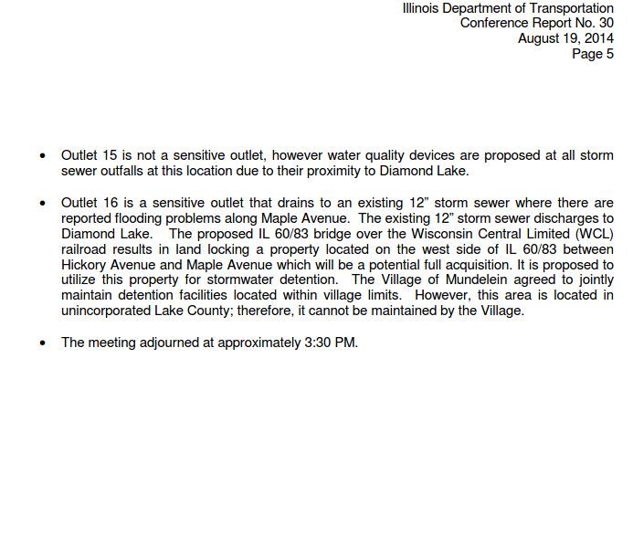
6 to minimize the impact to the. Two adjacent alternate sites currently owned by the Department have been evaluated and proposed to accommodate compensatory storage between the 10 year and 100 year storm profiles, but do not provide adequate depth to accommodate the 0 year to 10 year storm profiles. This amount would be provided in the proposed right-of-way at the Diamond lake Sports Complex. Similarly, stormwater detention in this vicinity has been evaluated and is proposed to be accommodated via oversized in-line storm sewer along IL 60/83. Stormwater detention is not proposed to be stored within the property. A drainage Best Management Practice (BMP) for filtering of the storm sewer discharge prior to release to the floodplain is proposed within the needed right-of-way from the. b. The shared-use path will be constructed in accordance with requirements of the Illinois Highway Code. 5. Evidence of Opportunity for Public Review and Comment A newspaper ad will be posted to allow the public an opportunity to review and comment on the Section 4(f) impacts. 6. Evidence of Coordination with Officials(s) with Jurisdiction a. October 1, 2008 Department information request to MPRD for properties with LCWF/OLSAD funding, found in Appendix B. b. October 16, 2008 Project initiation letter, found in Appendix B. c. 5/17/2011, 4/25/2013, 7/9-10/2013, 10/4/2013 Various correspondence concerning LWCF and OSLAD funding used for the Diamond Lake Sports Complex, found in Appendix B. d. June 28, 2013 Project status and property impacts coordination meeting with IDOT and MPRD, found in Appendix B. e. August 19, 2014 Drainage and Property impacts coordination meeting with the Department, the Village of Mundelein, Lake County Forest Preserve District, and MPRD, found in Appendix B. Page 4 of 5
7 f. A copy of the letter from the Official with Jurisdiction providing concurrence with the determination that there will be no adverse effect to the resource (will be inserted upon receipt of concurrence) is found in Appendix B. 7. Supporting Documentation a. Project Location Map... Appendix C b. Section 4(f) Property with Impacts... Appendix C c. Aerial Photograph with the Section 4(f) Property... Appendix C d. Photographs of the Resource... Appendix D e. Other Correspondence and Documents... Appendix E Page 5 of 5
8 APPENDICES Appendix A Appendix B Appendix C Appendix D Appendix E Public Information Meetings Official with Jurisdiction Project Drawings Photographs Other Correspondence and Documents
9 APPENDIX A Public Information Meetings Public Information Meeting #1 March 25, 2009 Public Information Meeting Summary Public Meeting No. 1 was held on Wednesday, March 25, 2009 at the Mundelein Police Station, 221 N. Lake Street, from 4:00 pm to 7:00 pm. The meeting was an open house format with a continuously running PowerPoint presentation and eleven exhibit boards for review. Separate tables displayed key outreach elements including Community Advisory Group Membership forms, public meeting comment forms, and a project survey. 79 people signed the register 20 people indicated that they are interested in becoming a member of the Community Advisory Group 10 people are either elected or appointed officials based on how they signed in at the public meeting The top three issues in developing the project are: 1 Roadway Safety 2 Traffic Congestion 3 Rail Crossing Alternatives The top three conditions experienced traveling along the Illinois Route 60/83 corridor are: 1 Traffic Congestion 2 Rail Crossing Delays 3 Adverse Travel Time 17 people made written comments with 14 different topics.
10
11
12
13 Public Information Meeting #2 October 22, 2013 Public Information Meeting Summary Public Meeting No. 2 was held on Tuesday, October 22, 2013, at the DoubleTree Hotel, 510 E. IL Route 83, from 4:00 pm to 7:00 pm. The meeting was an open house format with a continuous running PowerPoint presentation and twenty exhibit boards for review. A separate table displayed key outreach elements including the Community Advisory Group workshop binder, stakeholder involvement plan, context audit, and project website. A project brochure and comment form was also provided to all attendees. All meeting attendees were welcome to provide their comments, suggestions, issues, and concerns. The meeting was attended by 73 people; 15 comment forms were received at the meeting itself. The PowerPoint presentation was held in a separate but adjacent room with 51 of the 73 attendees viewing the presentation. There were no media representatives identified in attendance from the registration. Fifteen written comment forms were received during the public meeting. Additional written comment forms were requested to be received by November 5, Six additional comment cards were received subsequent to the public information meeting. The written comment forms submitted covered a variety of topics, briefly summarized as follows: Sidewalks are needed Keep the at-grade railroad crossing in order to maintain access Concerned with the impacts that would be created with right-of-way acquisition Concerned with stormwater and floodplain impacts Build the road now Construct the road over the railroad tracks Have shoulders to accommodate bicyclist Concerned with the impact the proposed improvement will have on groundwater Construct a grade separation with the railroad tracks either over or under The proposed sidewalk should extend from Diamond Lake Road to IL 60 Extend the sidewalk along IL 176 west of IL 60/83 Include a crosswalk on the east leg of the Midlothian Road Intersection
14
15
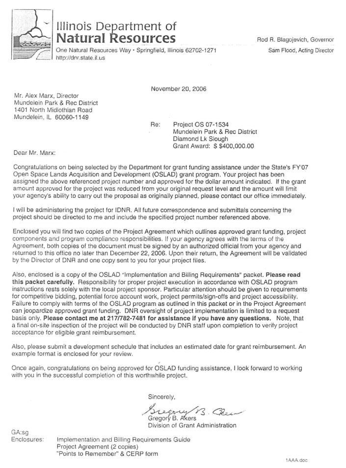
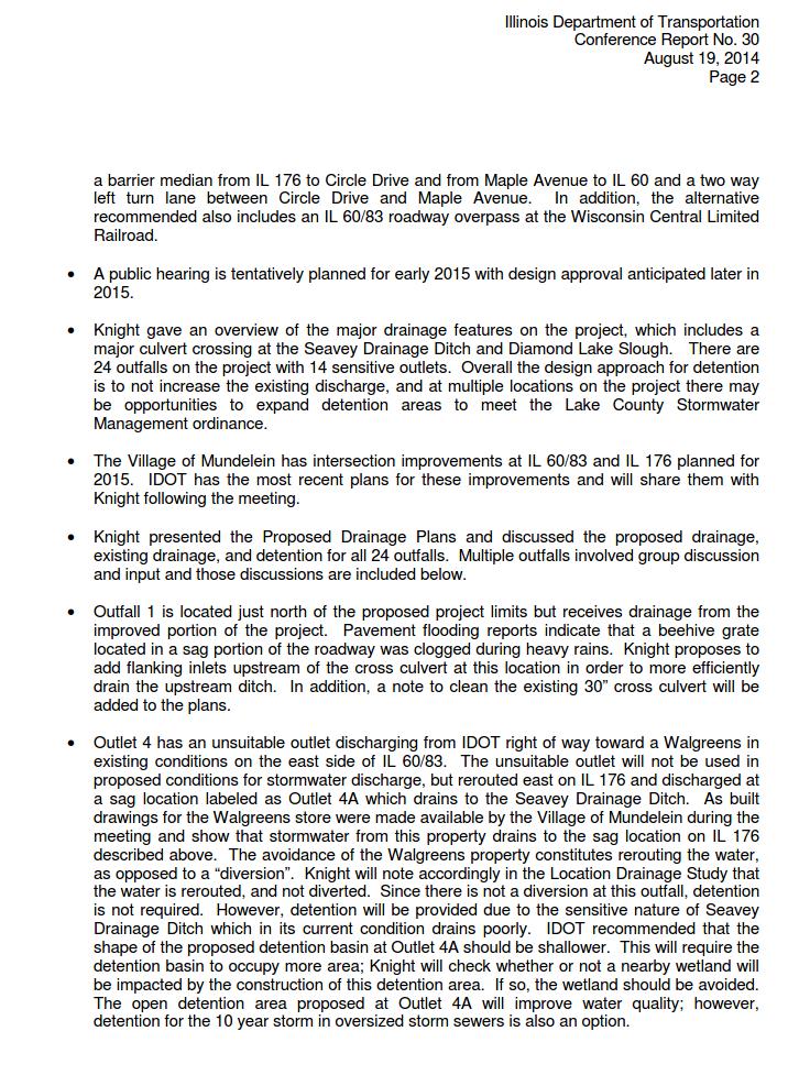
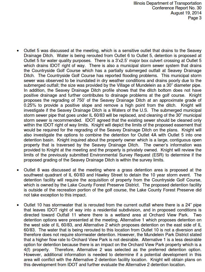
16 APPENDIX B Official With Jurisdiction The concurrence letter will be inserted when available LWCF and OSLAD Funding Documentation January 28, 2000 November 20, 2006 January 19, 2007 Letter from IDNR to MPRD concerning receiving Land and Water Conservation Funds (LWCF) for Diamond Lake Slough Letter from Illinois Department of Natural Resources (IDNR) to Mundelein Park and Recreation District (MPRD) concerning receiving Open Space Lands Acquisition & Development (OSLAD) funding for Diamond Lake Slough (now ) Letter from IDNR to MPRD concerning Diamond Lake Slough Project Agreement Correspondence with Mundelein Park and Recreation District October 01, 2008 May 17, 2011 April 25, 2013 July 09, 2013 July 10, 2013 October 04, concerning LWCF received by MPRD in the amount of $200,000 and a partially funded OSLAD grant for another project concerning snowmobile access to John Wiech Park from Diamond Lake Sports Complex. MPRD explained the purpose of the park. concerning the original agreement(s) for LWCF and OSLAD funding concerning snowmobile access to John Wiech Park from Diamond Lake Sports Complex. MPRD will research to find original document. concerning OSLAD funding concerning an update to LWCF & OSLAD funding Conference Report July 11, 2013 August 19, 2014 Conference Report concerning a meeting between the Mundelein Park & Recreation District (MPRD), Illinois Department of Transportation (IDOT), and Knight E/A, Inc. that discussed project status, progress, and property impacts. Conference Report concerning a meeting between the MPRD, the Village of Mundelein, Lake County Forest Preserve District, IDOT, and Knight E/A, Inc. that discussed proposed drainage and the associated impacts.
17 Mailings October 16, 2008 Project Initiation Letter Miscellaneous Title Insurance and Plat of Survey
18
19
20
21
22
23
24
25
26
27
28
29
30
31
32
33
34
35
36
37
38
39
40
41
42
43
44
45
46
47
48
49
50
51
52
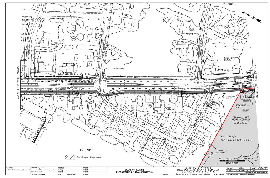
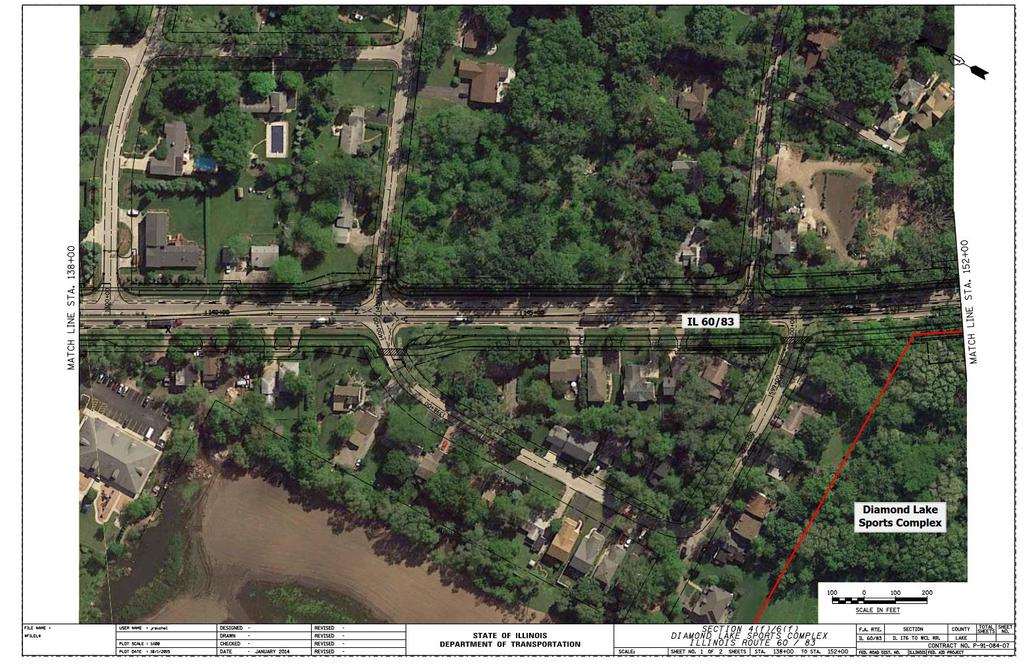
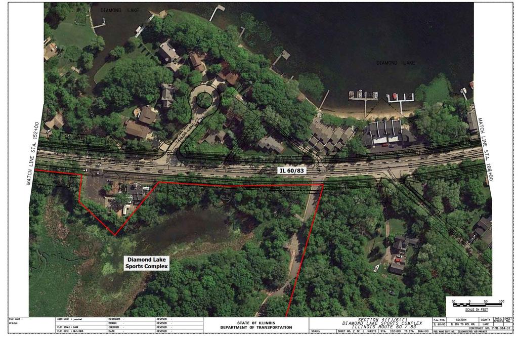
53 APPENDIX C Project Drawings Project Location Map An exhibit that shows the 4(f) property in relation to IL 60/83 and the surrounding area. 4(f) Property Exhibit Two sheets highlighting the 4(f) property with a description and quantity of the impacts. Aerial Photograph Exhibit Two aerial photograph sheets highlighting the 4(f) property showing the proposed plan.


54 PROJECT LOCATION Project Limit SECTION 4(f) PROPERTY LOCATION Project Limit
55
56
57
58
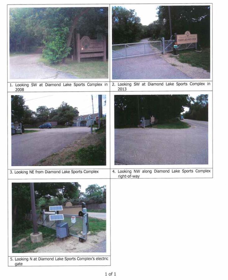
59 APPENDIX D Photographs
60
61 APPENDIX E Other Correspondence and Documents Correspondence April 22, 1994 Letter from Illinois Department of Conservation to Mundelein Park and Recreation District (MPRD) concerning a snowmobile grant for Diamond Lake Slough (now ) Record of Telephone Conservation October 01, 2013 Record of telephone conservation between the Illinois Department of Transportation and the Illinois Department of Natural Resources concerning a grant for snowmobile access. Other Tax Parcel Map Tax Parcel
62
63
64
65
66
67
The Illinois Department of Transportation and Lake County Division of Transportation. Route 173, including the Millburn Bypass
 The Illinois Department of Transportation and Lake County Division of Transportation welcome you to this Public Hearing for U.S. Route 45 from Illinois Route 132 to Illinois Route 173, including the Millburn
I-494 Rehabilitation Project SP (I-394 to Fish Lake Interchange) June 2014 Section 4(f) De Minimis Determination
 June 2014 Section 4(f) De Minimis Determination") I-494 Rehabilitation Project SP 2785-330 (I-394 to Fish Lake Interchange) June 2014 Section 4(f) De Minimis Determination State Project Number 2785-330 Federal Project No. NHPP-I494 (002) Trunk Highway:
I-494 Rehabilitation Project SP 2785-330 (I-394 to Fish Lake Interchange) June 2014 Section 4(f) De Minimis Determination State Project Number 2785-330 Federal Project No. NHPP-I494 (002) Trunk Highway:
The Village of Sugar Grove, in partnership with Kane County, the Illinois Department of Transportation, and the Illinois Tollway welcomes you to the
 The Village of Sugar Grove, in partnership with Kane County, the Illinois Department of Transportation, and the Illinois Tollway welcomes you to the first Public Meeting for the proposed interchange improvement
Elgin O Hare Western Access Project Local Advisory Committee. February 10, 2014
 Elgin O Hare Western Access Project Local Advisory Committee February 10, 2014 Agenda Project status update Design and construction Funding Aesthetics Project events and outreach Land acquisition Next
PROJECT STATEMENT LOCATION/DESIGN PUBLIC HEARING. 19 th AVENUE NORTH EXTENSION PROJECT FROM SPRINGDALE DRIVE TO NORTH 2 ND STREET/U.S.
 PROJECT STATEMENT LOCATION/DESIGN PUBLIC HEARING 19 th AVENUE NORTH EXTENSION PROJECT FROM SPRINGDALE DRIVE TO NORTH 2 ND STREET/U.S. 67 HEARING LOCATION: ERICKSEN COMMUNITY CENTER 1401 11 TH AVENUE NORTH
PARTF Scoring System for Grants
 PARTF Scoring System for Grants The members of the N.C. Parks and Recreation Authority use the PARTF scoring system as one of several tools to select grant recipients. Please provide all of the information
THREE-YEAR CAPITAL IMPROVEMENT PLAN FY
 THREE-YEAR CAPITAL IMPROVEMENT PLAN FY2016 2018 Annual CIP Development Process Public Works & Engineering Divisions Prepare List of Capital Needs and Recommended Deferred Maintenance Public Works & Engineering
WELCOME! 8 8:30 6: TH STREET IMPROVEMENTS. Open House. Presentation & Q&A
 WELCOME! 168 TH STREET IMPROVEMENTS 6:30 Open House 7 8 Presentation & Q&A 8 8:30 Open House WELCOME Todd Pfitzer City of Omaha Engineer Bob Stubbe City of Omaha Public Works Director Jon Meyer Project
ARGENTA TRAIL (CSAH 28/63) REALIGNMENT SOUTH PROJECT (CP 63-25)
 REALIGNMENT SOUTH PROJECT (CP 63-25)") ARGENTA TRAIL (CSAH 28/63) REALIGNMENT SOUTH PROJECT (CP 63-25) Preliminary Design Report February 2015 Prepared For: City of Inver Grove Heights Dakota County Prepared By: Kimley-Horn and Associates,
ARGENTA TRAIL (CSAH 28/63) REALIGNMENT SOUTH PROJECT (CP 63-25) Preliminary Design Report February 2015 Prepared For: City of Inver Grove Heights Dakota County Prepared By: Kimley-Horn and Associates,
Public Hearing. Charlotte County-Punta Gorda MPO - Meeting Rooms A and B March 14, open house at 4 p.m., formal presentation at 5 p.m.
 Public Hearing Charlotte County-Punta Gorda MPO - Meeting Rooms A and B March 14, 2019 open house at 4 p.m., formal presentation at 5 p.m. Welcome to the Public Hearing for the Harborview Road (CR 776)
Chapter 13: Implementation Plan
 Implementation A. Introduction The Implementation Plan, in table form on the following pages, provides a summary of all the Action Items recommended in Chapters 2 through 12. The table also indicates which
WURZBACH PARKWAY WURZBACH PARKWAY
 WURZBACH PARKWAY WURZBACH PARKWAY From Lockhill-Selma Rd to NW Military Hwy Open NW Military HouseHwy/Lockhill-Selma Open House Barshop Jewish Community Center December Barshop Jewish 14, 2017 Community
CAG Meeting #4 Summary
 General Information, Overview, Purpose, and Goals The fourth Community Advisory Group (CAG) meeting for the Sugar Grove Parkway (IL 47) Interchange at the Reagan Memorial Tollway (I-88) Improvement Study
DuPage Mayors and Managers Conference June 21, 2013 TRANSPORTATION PROGRAM (STP) WORKSHOP
 WORKSHOP") DuPage Mayors and Managers Conference June 21, 2013 TRANSPORTATION PROGRAM (STP) WORKSHOP Lombard Village Hall Marilin Solomon, P.E. Field Engineer West Division (Central & North Central Cook County, DuPage
DuPage Mayors and Managers Conference June 21, 2013 TRANSPORTATION PROGRAM (STP) WORKSHOP Lombard Village Hall Marilin Solomon, P.E. Field Engineer West Division (Central & North Central Cook County, DuPage
ITS Concept Development Activity Descriptions
 ITS Concept Development Activity Descriptions October 2015 Procedures are subject to change without notice. Check the NJDOT website to ensure this is the current version. Table of Contents Concept Development
Bostwick Road. Municipal Class Environmental Assessment. Public Information Centre #2 June 14, City of London
 Bostwick Road Municipal Class Environmental Assessment Public Information Centre #2 June 14, 2017 Welcome! Welcome to the 2 nd Public Information Centre for the. Representatives from the and the consulting
OVERMOUNTAIN VICTORY TRAIL BURKE CALDELL CORRIDOR FEASIBLITY STUDY REQUEST FOR QUALIFICATIONS CALDWELL COUNTY PATHWAYS
 OVERMOUNTAIN VICTORY TRAIL BURKE CALDELL CORRIDOR FEASIBLITY STUDY REQUEST FOR QUALIFICATIONS CALDWELL COUNTY PATHWAYS Caldwell County Pathways along with our co-partners City of Lenoir, Town of Gamewell,
MPRD s Keith Mione (Community) Park Midlothian Road Entrance Traffic Signals
 Park Midlothian Road Entrance Traffic Signals") MPRD s Keith Mione (Community) Park Midlothian Road Entrance Traffic Signals Purpose: The Midlothian Road entrance to Mundelein Park & Recreation District s (MPRD s) Keith Mione (Community) Park would
MPRD s Keith Mione (Community) Park Midlothian Road Entrance Traffic Signals Purpose: The Midlothian Road entrance to Mundelein Park & Recreation District s (MPRD s) Keith Mione (Community) Park would
Yadkin River Greenway Feasibility Study Fact Sheet Village of Clemmons, Town of Lewisville, Town of Bermuda Run
 Fact Sheet Village of Clemmons, Town of Lewisville, Town of Bermuda Run Project Background The Yadkin River Greenway Feasibility Study is a joint project with the Village of Clemmons, the Town of Bermuda
Kankakee River Bridge & Track Improvements Supplemental Environmental Assessment. May 5, 2016
 Kankakee River Bridge & Track Improvements Supplemental Environmental Assessment May 5, 2016 1 History: Chicago-St. Louis Corridor Since 1980 s IDOT has been looking at this corridor for high-speed service
PRELIMINARY REPORT. HIGHWAY 18 CORRIDOR NEIGHBORHOOD PLAN VILLAGE OF DOUSMAN November, 2014
 PRELIMINARY REPORT HIGHWAY 18 CORRIDOR NEIGHBORHOOD PLAN VILLAGE OF DOUSMAN November, 2014 This preliminary report presents the initial recommendations for land use within the Highway 18 corridor along
PUBLIC HEARING. Thursday, December 14, 2017 FDOT Urban Office 2198 Edison Avenue Jacksonville, FL 32204
 DISTRICT TWO PUBLIC HEARING I 10 (SR 8) from I 295 to I 95 Project Development & Environment Study Duval County, Florida Financial Project Number 213326 2 22 01 Efficient Transportation Decision Making
Hunt Highway CELESTE PEMBERTON, CFM, CPM PINAL COUNTY CARLOS SANCHEZ SORIA, PE T.Y. LIN INTERNATIONAL
 Hunt Highway CELESTE PEMBERTON, CFM, CPM PINAL COUNTY CARLOS SANCHEZ SORIA, PE T.Y. LIN INTERNATIONAL Agenda Design Concept Report Phase 1 Phase 2 Phase 3 Phase 4 Phase 5 Questions Design Concept Report
Pennsy Greenway Trail
 Town of Schererville Pennsy Greenway Trail DES. #s: 0401062, 1173595 & 1382661 Construction of Pennsy Greenway Trail beginning at Wilhelm Street and continuing northwest along the former Penn Central railroad
SH 199 Corridor Master Plan. Community Meeting No. 2 May 31, 2017
 Community Meeting No. 2 May 31, 2017 Transportation Projects On or Near SH 199 SH 199 from 0.3 miles south of FM 1886 to south end of Lake Worth bridge Construct freeway mainlanes and frontage roads 10-Year
Alternatives Development Three conceptual alternatives were developed for the Race Road/Jessup Village Planning Study and are described below:
 Race Road/Jessup Village Planning Study (H550601) Project Newsletter Spring 2015 Project Description The Study Team, consisting of staff from Anne Arundel County (Department of Public Works and Department
2. AGENCY COORDINATION AND PUBLIC INVOLVMENT
 2. AGENCY COORDINATION AND PUBLIC INVOLVMENT This chapter discusses the process carried out for conducting agency coordination and public involvement activities. TECHNICAL ADVISORY COMMITTEE A Technical
7th Avenue Creek Master Plan Development Project. City of St. Charles, IL. IAFSM CONFERENCE March 14, 2018 MARKET
 7th Avenue Creek Master Plan Development Project MARKET City of St. Charles, IL IAFSM CONFERENCE March 14, 2018 7 TH AVENUE CREEK PROJECT AREA 2 2008 RAIN EVENT 3 RESIDENTIAL STRUCTURE FLOODING COMMERCIAL
RECREATION AND OPEN SPACE ELEMENT
 RECREATION AND OPEN SPACE ELEMENT Last amended August 19, 2008 Table of Contents Objective Page 5.1 Park system defined... 5-1 5.2 Access to parks and recreational facilities... 5-2 5.3 Recreation and
New York Avenue Streetscape and Trail Project Public Meeting #1 Summary
 New York Avenue Streetscape and Trail Project Public Meeting #1 Summary I. King Jordan Student Academic Center (SAC) Gallaudet University, Washington, DC February 23, 2017 Table of Contents 1.0 Introduction...
Drexel, Barrell & Co.
 Drexel, Barrell & Co. June 18, 2018 Engineers/Surveyors Boulder Colorado Springs Greeley 3 South 7 th Street Colorado Springs, Colorado 80905-1501 719 260-0887 719 260-8352 Fax El Paso County Planning
TRANSPORTATION ELEMENT GOALS, OBJECTIVES, AND POLICIES
 TRANSPORTATION ELEMENT GOALS, OBJECTIVES, AND POLICIES GOAL 2 The City shall provide a safe, convenient, effective, and energy efficient multimodal transportation system which is coordinated with the Future
Project Overview. Get Involved. Public Information Meeting. Contact Information
 Get Involved VDOT representatives will review and evaluate information received as a result of this meeting. Please fill out the comment sheet provided in this brochure if you have any comments or questions.
Executive Summary. NY 7 / NY 2 Corridor
 Executive Summary NY 7 / NY 2 Corridor Transportation and Land Use Study December 2005 Prepared for: Town of Colonie Capital District Transportation Committee Prepared by: Introduction: Land use decisions
PART 1: PROJECT SUMMARY. The application is Attachment A. The site plan is Attachment B.
 Belleterre Subdivision Sketch Plan Town Board 8.7.17 Belleterre Subdivision Sketch Plan PART 1: PROJECT SUMMARY Applicant: Bowman Development Project Size: +/- 20.85 acres Parcel Number: 01115104 and 01115121
Project Overview. Fairfax County Parkway Widening Fairfax County. Get Involved. Public Information Meeting. Contact Information
 Get Involved VDOT representatives will review and evaluate information received as a result of this meeting. Please fill out the comment sheet provided in this brochure if you have any comments or questions.
Secrest Short Cut and Monroe Expressway Small Area Plan AUGUST 29, 2018
 Secrest Short Cut and Monroe Expressway Small Area Plan AUGUST 29, 2018 Background and Process Monroe Expressway will be open by the end of 2018 Union County and Indian Trail identified a need to revisit
Drexel, Barrell & Co.
 Drexel, Barrell & Co. December 21, 2018 Engineers/Surveyors Boulder Colorado Springs Greeley 3 South 7 th Street Colorado Springs, Colorado 80905-1501 719 260-0887 719 260-8352 Fax El Paso County Planning
CITY OF ZEELAND PLANNING COMMISSION
 APPLICATION FOR SITE PLAN REVIEW AND SPECIAL LAND USE Date City Official App. Filing Fee Rec'd ($350) NOTE TO APPLICANT: Please submit this application for Site Plan Review along with twenty (20) copies
City of Toronto. Emery Village Transportation Master Plan
 City of Toronto Emery Village Transportation Master Plan May 2009 Emery Village Transportation Master Plan Toronto, ON May 2009 Consulting Inc. 100 York Blvd., Suite 300 Richmond Hill, ON L4B 1J8 Tel:
Meeting Display Boards for Public Hearing on the Wilson Transfer Station Project held Tuesday, February 18, 2014.
 Meeting Display Boards for Public Hearing on the Wilson Transfer Station Project held Tuesday, February 18, 2014. Board 1: Welcome Welcome to the Wilson Transfer Station Project Public Hearing. The purpose
Provide and maintain sufficient public parks, recreation facilities, and open space to meet the recreational needs of County residents and visitors.
 (ROS) Goal Provide and maintain sufficient public parks, recreation facilities, and open space to meet the recreational needs of County residents and visitors. OBJECTIVE ROS.01 The County shall acquire,
STATE OF TENNESSEE DEPARTMENT OF TRANSPORTATION ENVIRONMENTAL DIVISION
 STATE OF TENNESSEE DEPARTMENT OF TRANSPORTATION ENVIRONMENTAL DIVISION Suite 900 - James K. Polk Building 505 Deaderick Street Nashville, Tennessee 37243-0334 MEMORANDUM TO: FROM: Files Joe W. Matlock,
112th Avenue Light Rail Options Concept Design Report JUNE 2010 PREPARED FOR PREPARED BY TBG PGH
 112th Avenue Light Rail Options Concept Design Report JUNE 2010 PREPARED FOR PREPARED BY TBG060310124909PGH C ontents Introduction 1 Project Overview 1 Public Involvement and Technical Coordination 4 Description
I. DESCRIPTION OF PROPOSED ACTION... 1 A. General Description... 1 B. Historical Resume and Project Status... 2 C. Cost Estimates...
 PROJECT COMMITMENTS SUMMARY... S-1 1. Type of Action... S-1 2. Description of Action... S-1 3. Summary of Purpose and Need... S-1 4. Alternatives Considered... S-2 5. NCDOT Alternatives Carried Forward...
9 CITY OF VAUGHAN OFFICIAL PLAN AMENDMENT NO BOCA EAST INVESTMENTS LIMITED
 9 CITY OF VAUGHAN OFFICIAL PLAN AMENDMENT NO. 631 - BOCA EAST INVESTMENTS LIMITED The Planning and Economic Development Committee recommends the adoption of the recommendations contained in the following
Overall Map. Chicago. St. Louis. Summit. Joliet. Dwight. Pontiac. Bloomington-Normal Lincoln. Springfield. Carlinville. Alton EXPERIENCE IT YOURSELF.
 Overall Map Summit Chicago Bloomington-Normal Lincoln New Station Planned New Station Planned Dwight Pontiac Joliet Pedestrian overpass and second platform planned Higher speed service began in this section
Section 4(f) De minimis Impact Documentation
 De minimis Impact Documentation") 1. Project Description Section 4(f) De minimis Impact Documentation Wadsworth Road at Kilbourne Road Section No. 13-00999-47-ES Lake County Forest Preserve District Lake County, Illinois a. Project Number:
1. Project Description Section 4(f) De minimis Impact Documentation Wadsworth Road at Kilbourne Road Section No. 13-00999-47-ES Lake County Forest Preserve District Lake County, Illinois a. Project Number:
Asbury Chapel Subdivision Sketch Plan
 Asbury Chapel Subdivision Sketch Plan PART 1: PROJECT SUMMARY Applicant: NVR Inc. Project Size: +/- 76.13 acres Parcel Numbers: 02101112,02116101,02116112, 02116113 Current Zoning: Transitional Residential
East Panorama Ridge Concept Plan Amendment
 Page 1 of 7 L003 : East Panorama Ridge Concept Plan Amendment Corporate NO: L003 Report COUNCIL DATE: March 4, 2002 REGULAR COUNCIL LAND USE TO: Mayor & Council DATE: February 27, 2002 FROM: General Manager,
PROJECT BACKGROUND. Preliminary Design Scope and Tasks
 PROJECT BACKGROUND Preliminary Design Scope and Tasks The purpose of this Study is the development of preliminary designs for intersection improvements for Trunk Highway (TH) 36 at the intersections of
7.0 DRAFT SECTION 4(f) EVALUATION
 EVALUATION") 7. DRAFT SECTION 4(f) EVALUATION 7.1 Background Information and Regulatory Requirements This chapter presents the existing conditions and potential effects on parks, recreation areas, wildlife and waterfowl
7. DRAFT SECTION 4(f) EVALUATION 7.1 Background Information and Regulatory Requirements This chapter presents the existing conditions and potential effects on parks, recreation areas, wildlife and waterfowl
Appendix I. Checklists
 Appendix I Checklists Town of Greenwich Drainage Manual Department of Public Works - Engineering Division Town Hall - 101 Field Point Road, Greenwich, CT 06836-2540 Phone 203-622-7767 - Fax 203-622-7747
Saranac River Trail Greenway C O N D I T I O N S R E P O R T
 Saranac River Trail Greenway C O N D I T I O N S R E P O R T City of Plattsburgh Clinton County, NY For: Clinton County Final Issued: March 22, 2017 This document was prepared for the New York State Department
Gold Line Bus Rapid Transit Transit Oriented Development (BRTOD) Helmo Station Area Plan
 Helmo Station Area Plan") Appendix F Gold Line Bus Rapid Transit Transit Oriented Development (BRTOD) Helmo Station Area Plan Introduction and Purpose of the Plan The Gold Line Bus Rapid Transit facility is an eleven-mile dedicated
Appendix F Gold Line Bus Rapid Transit Transit Oriented Development (BRTOD) Helmo Station Area Plan Introduction and Purpose of the Plan The Gold Line Bus Rapid Transit facility is an eleven-mile dedicated
SR-2 Freeway Terminus Improvement Project
 SR-2 Freeway Terminus Improvement Project Welcome! Public Hearing, Mayberry Elementary June 16, 2009, 6:30 p.m. 8:30 p.m. Agenda 6:30 PM 6:50 PM Registration and Open House 6:50 PM 7:00 PM Welcome and
Coco Palms Community Development District. Engineer s Report Infrastructure Improvements
 Coco Palms Community Development District Engineer s Report Infrastructure Improvements Prepared for Coco Palms Community Development District Board of Supervisors Miami-Dade County, Florida Prepared by
RESOLUTION NO. R Refining the route, profile and stations for the Downtown Redmond Link Extension
 RESOLUTION NO. R2018-32 Refining the route, profile and stations for the Downtown Redmond Link Extension MEETING: DATE: TYPE OF ACTION: STAFF CONTACT: Capital Committee Board PROPOSED ACTION 09/13/2018
TOWN OF BETHLEHEM MEETING SUMMARY LOCAL WATERFRONT REVITALIZATION PROGRAM UPDATE
 TOWN OF BETHLEHEM LOCAL WATERFRONT REVITALIZATION PROGRAM UPDATE MEETING SUMMARY Purpose: LWRP Update Public Workshop #3 Date and Time: October 24, 2017, 6:00 pm - 8:00 pm Location: Town Hall, 445 Delaware
State Project No Heroes Tunnel
 Public Scoping Meeting State Project No. 167-108 Bridge No. 00773 Heroes Tunnel Route 15 Wilbur Cross Parkway Through West Rock Ridge Towns of Hamden, Woodbridge City of New Haven Agenda Show Project Location
Camden County Development Regulations. Updated February 2017
 Camden County Development Regulations Updated February 2017 GENERAL MEETING SCHEDULE OF THE CAMDEN COUNTY PLANNING BOARD All meetings will convene at 6:00 PM on the 4th Tuesday of each month and will be
FY Capital Improvement Program Arroyo Projects
 FY 219-223 Capital Improvement Program FY 218 FY 219 FY 22 FY 221 FY 222 FY 223 1 2 3 4 5 6 7 8 9 1 Hahamongna - Implement Master Plan - Oak Grove Area Improvements (7756) Hahamongna - Implement Master
Ashland BRT Environmental Assessment: logos of CTA, CDOT, Chicago Department of Housing and Economic Development
 Ashland BRT Environmental Assessment: logos of CTA, CDOT, Chicago Department of Housing and Economic Development Overview The Chicago Transit Authority (CTA), in partnership with the Chicago Department
Application for Site Plan Review
 Application for Site Plan Review City of Pontiac Office of Land Use and Strategic Planning 47450 Woodward Ave, Pontiac, MI 48342 T: 248.758.2800 F: 248.758.2827 Property/Project Address: Sidwell Number:
4-Town Comprehensive Plan DRAFT 7/30/07
 4-Town Comprehensive Plan DRAFT 7/30/07 Acknowledgements ning Committee Town of Harrisburg Norman Roof Randy Nicol Town of Martinsburg Terry Thisse Paul Kelly Town of Montague Jan Bagdanowicz Wendy Perry
SPECIFIC PLAN Requirements
 CITY OF LANCASTER PLANNING DEPARTMENT 44933 Fern Avenue, Lancaster, California 93534 (661) 723-6100 SPECIFIC PLAN Requirements Purpose The purpose of a specific plan is to provide for the logical development
Gadsden County Planning Commission Agenda Request
 Date of Meeting: November 16, 2017 To: From: Through: Subject: Gadsden County Planning Commission Agenda Request Honorable Chairperson and Members of the Board Jill A. Jeglie, AICP, Senior Planner Clyde
Capital Projects in and near Odenton Town Center
 Capital Projects in and near Odenton Town Center Map ID Anne Arundel County Department of Public Works This project provides for the design, right of way acquisition, and construction of approximately
PLANNED UNIT DEVELOPMENT & SUBDIVISION STAFF REPORT Date: May 18, 2017
 & PUD-0000102-2017 PLANNED UNIT DEVELOPMENT & SUBDIVISION STAFF REPORT Date: May 18, 2017 NAME SUBDIVISION NAME Dauphin Creek Estates Subdivision Dauphin Creek Estates Subdivision LOCATION CITY COUNCIL
A Claustrophobic Corridor Grows Up
 A Claustrophobic Corridor Grows Up Presenters: Chris Bauserman, PE, PS Delaware County Engineer Jeff Griffin, PE Burgess & Niple, Inc. Brian Moore, PE Burgess & Niple, Inc. PROJECT OVERVIEW Sawmill Parkway
Metropolitan Parks and Open Space Commission
 Business Item No. 2013-xxx Metropolitan Parks and Open Space Commission Meeting date: October 1, 2013 For the Community Development Committee meeting of October 7, 2013 Subject: Mendota-Lebanon Hills Greenway
Draft Rhode Island Stormwater Design and Installation Standards Manual
 Draft Rhode Island Stormwater Design and Installation Standards Manual Summary The May 2009 Public Review Draft version of the RI Stormwater Design and Installation Standards Manual consists of approximately
TOWNSHIP OF LOGAN SOIL & FILL IMPORTATION AND PLACEMENT APPLICATION SUBMITTAL CHECKLIST
 TOWNSHIP OF LOGAN SOIL & FILL IMPORTATION AND PLACEMENT APPLICATION SUBMITTAL CHECKLIST Applications: 5 copies of application - Applicant will reproduce the copies at his/her costs. The Township Clerk
Definitions. Average Daily Traffic Demand (ADT): The actual number or projected number of cars that pass a point in a 24-hour period.
: The actual number or projected number of cars that pass a point in a 24-hour period.") Definitions Access Management: A combination of physical techniques and transportation policies used to control the flow of traffic between roads and the surrounding lands. Alternative City Form Scenarios:
Definitions Access Management: A combination of physical techniques and transportation policies used to control the flow of traffic between roads and the surrounding lands. Alternative City Form Scenarios:
Note: Staff reports can be accessed at Zone: I-3. Tier:
 The Maryland-National Capital Park and Planning Commission Prince George s County Planning Department Development Review Division 301-952-3530 Note: Staff reports can be accessed at www.mncppc.org/pgco/planning/plan.htm.
Request for Statement of Interest in Implementation of the Roosevelt Road Redevelopment Plan
 425 Hillside Avenue Request for Statement of Interest in Implementation of the Roosevelt Road Redevelopment Plan I. INTRODUCTION The is seeking the services of a qualified consulting firm to prepare plans
City of Bonney Lake Allan Yorke Park. MASTER PLAN SUMMARY REPORT June 30, 2016
 City of Bonney Lake Allan Yorke Park MASTER PLAN SUMMARY REPORT June 30, 2016 TABLE OF CONTENTS INTRODUCTION PUBLIC INVOLVEMENT PROCESS MASTER PLAN North Park Central Park South Park East Park Field Development
Longmeadow Parkway Fox River Bridge Corridor. August 6, 2015
 Longmeadow Parkway Fox River Bridge Corridor August 6, 2015 Longmeadow Parkway Bridge Corridor 5.6 miles from Huntley Road to IL 62 Unique municipal/county/state/federal partnership Links Randall Road
Citizen Information Meeting
 Prince William County Government Citizen Information Meeting Vint Hill Road Extension May 11, 2016 Benefits: Route 28 Corridor Improvement Program Estimated significant cost savings versus bidding these
Burton Station Village Community Meeting February 26, 2014
 February 26, 2014 SGA Plan Overview Recent announcements by the City of Norfolk regarding the closure of Lake Wright Golf Course and retail development proposals Update on infrastructure improvement plans
NAPA COUNTY PUBLIC WORKS Standards & Specifications
 Roadway Design & Construction Manual (Table of Contents) 1. Chapter 1: General Provisions 1.1 Short Title 1.2 Jurisdiction 1.3 Purpose and Effect 1.4 Enactment Authority 1.5 Amendment and Revisions 1.6
SAN MARTIN BOULEVARD OVER RIVIERA BAY PROJECT DEVELOPMENT & ENVIRONMENT (PD&E) STUDY
 STUDY") KICK-OFF PRESENTATION SAN MARTIN BOULEVARD OVER RIVIERA BAY PROJECT DEVELOPMENT & ENVIRONMENT (PD&E) STUDY PROJECT IDENTIFICATION NUMBER (PID): #001036A May 13, 2015 1 2 PROJECT LOCATION PROJECT HISTORY
KICK-OFF PRESENTATION SAN MARTIN BOULEVARD OVER RIVIERA BAY PROJECT DEVELOPMENT & ENVIRONMENT (PD&E) STUDY PROJECT IDENTIFICATION NUMBER (PID): #001036A May 13, 2015 1 2 PROJECT LOCATION PROJECT HISTORY
Checklists. Project Name: Location: File Number: Date of Submittal: Reviewer: Date: Applicant: Contact Name: Phone Number:
 Applicant: Contact Name: Phone Number: Email: Project Name: Location: File Number: Date of Submittal: Reviewer: Date: Concept Plan Requirements: I. General Project Information 1. Address or parcel number
North Metro Natural Gas Pipeline Project Routing Study. Exhibit I: Comment and Response Document
 North Metro Natural Gas Pipeline Project Routing Study Exhibit I: Comment and Response Document North Metro Natural Gas Pipeline Project Routing Study This page intentionally left blank. North Metro Natural
HAZARD MITIGATION GOALS AND OBJECTIVES
 SEWRPC Community Assistance Planning Report No. 282, 2nd Edition CITY OF MILWAUKEE ALL HAZARDS MITIGATION PLAN UPDATE Chapter IV HAZARD MITIGATION GOALS AND OBJECTIVES [NOTE: Throughout this plan update
EXECUTIVE SUMMARY. Introduction
 EXECUTIVE SUMMARY Introduction State Route 68 is a designated scenic route that connects the world-renowned Monterey Peninsula to US Highway 101 and the Salinas Valley. SR 68 is a key route for bicycle,
Appendix E Section 4(f) Evaluation
 Evaluation") Appendix E Section 4(f) Evaluation Appendix E Draft Section 4(f) Evaluation E.1 Introduction This appendix addresses a federal regulation known as Section 4(f), which protects parks, recreation areas,
Appendix E Section 4(f) Evaluation Appendix E Draft Section 4(f) Evaluation E.1 Introduction This appendix addresses a federal regulation known as Section 4(f), which protects parks, recreation areas,
DESIGN & GREEN INFRASTRUCTURE UPDATE December 13, 2016
 DESIGN & GREEN INFRASTRUCTURE UPDATE December 13, 2016 Welcome & Introduction Michael J. Finn, P.E. City Engineer Summary of Public Outreach to Date Ground the work in established principles December 2015
Project phasing plan (if applicable) 12 copies of site plan
 12 copies of site plan") SITE PLAN REVIEW PERMIT APPLICATION City of Grand Haven, 11 N. Sixth Street, Grand Haven, MI 49417 Phone: (616) 847-3490 Fax: (616) 844-2051 Website: www.grandhaven.org 1. Project Information Address/location
SITE PLAN REVIEW PERMIT APPLICATION City of Grand Haven, 11 N. Sixth Street, Grand Haven, MI 49417 Phone: (616) 847-3490 Fax: (616) 844-2051 Website: www.grandhaven.org 1. Project Information Address/location
ILLINOIS 47 CORRIDOR PLANNING STUDY H E N R K A N E SEPTEMBER 2010
 WISCONSIN ILLINOIS 173 M 47 C ILLINOIS 47 H E 14 120 CORRIDOR PLANNING N R 176 STUDY Y SEPTEMBER 2010 72 20 47 90 72 20 RANDALL ROAD Participants Village of Burlington Village of Campton Hills City of
Ref: March 21, Ms. Jody Kablack Director of Planning and Community Development Town of Sudbury 278 Old Sudbury Road Sudbury, MA 01776
 35 New England Business Center Drive Suite 140 Andover, MA 01810-1066 Office: 978-474-8800 Fax: 978-688-6508 Web: www.rdva.com Ref: 7198 Director of Planning and Community Development Town of Sudbury 278
At Your Disposal CUP Amendment, Lot 20, Village Service Commercial, at 128 Bastille Dr. (PLN17-208)
") MEMORANDUM Archuleta County Development Services Planning Department 1122 HWY 84 P. O. Box 1507 Pagosa Springs, Colorado 81147 970-264-1390 Fax 970-264-3338 TO: Archuleta County Planning Commission FROM:
MEMORANDUM Archuleta County Development Services Planning Department 1122 HWY 84 P. O. Box 1507 Pagosa Springs, Colorado 81147 970-264-1390 Fax 970-264-3338 TO: Archuleta County Planning Commission FROM:
STREAM BUFFERS
 88-415 STREAM BUFFERS 88-415-01 PURPOSE In the Kansas City region and throughout the nation, vegetated stream buffers have been clearly shown to protect stream stability and related infrastructure, improve
SOUTHWEST CORRIDOR EXTENSION. Environmental Evaluation and Basic Engineering Results PUBLIC MEETING/OPEN HOUSE November 18, 2009
 SOUTHWEST CORRIDOR EXTENSION Environmental Evaluation and Basic Engineering Results PUBLIC MEETING/OPEN HOUSE November 18, 2009 AGENDA I. Welcome/Introductions II. Project Review and Status III. Environmental
Access Management: An Overview
 Figures 1-5 Below Evolution of development along a highway. In the early stages, land along the road is used for farming with little traffic generated. As time passes, the highway corridor becomes a de
PRELIMINARY CONDITIONAL USE SUBMITTAL CHECKLIST REQUIREMENTS
 This checklist must accompany your submittal as the cover page. CONDITIONAL USE Application Submittal Checklist for PRELIMINARY AND FINAL APPROVAL Per Winter Park Land Development Code Sec. 58-90 PRELIMINARY
13. PRELIMINARY PLAT NO MILLS FARM - Vicinity of the southeast corner of 159 th Street and Quivira Road
 13. corner of 159 th Street and Quivira Road 1. APPLICANT: HNTB Corporation is the applicant for this request. 2. REQUESTED ACTION: The applicant is requesting approval of a preliminary plat for a 383-lot
Mississippi Skyway Preliminary Engineering Report
 EXECUTIVE SUMMARY Mississippi Skyway Preliminary Engineering Report CITY OF RAMSEY, MINNESOTA DECEMBER 2014 City of RAMSEY EXECUTIVE SUMMARY Project Need and Intent The Mississippi Skyway pedestrian bridge
DRAFT PLAN PRESENTATION
 DRAFT PLAN PRESENTATION 1.23.2018 AGENDA Process Project Schedule Results from Visioning Workshop Draft Plan Highlights Concept Plans Feedback Next Steps PROJECT SCHEDULE KICK-OFF WORKSHOP August 29 th
Planned Development Review Revisions (Project No. PLNPCM )
") Planned Development Review Revisions (Project No. PLNPCM2014-00139) Standard residential development Planned Development Example: Smaller lot sizes than what is allowed to create open space amenity. What
Planned Development Review Revisions (Project No. PLNPCM2014-00139) Standard residential development Planned Development Example: Smaller lot sizes than what is allowed to create open space amenity. What