STATUS OF REVIEW: ENGINEER WILL COMPLY
|
|
|
- Brent Day
- 5 years ago
- Views:
Transcription
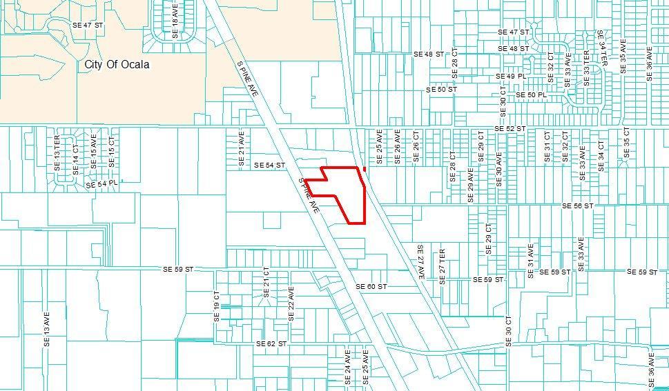
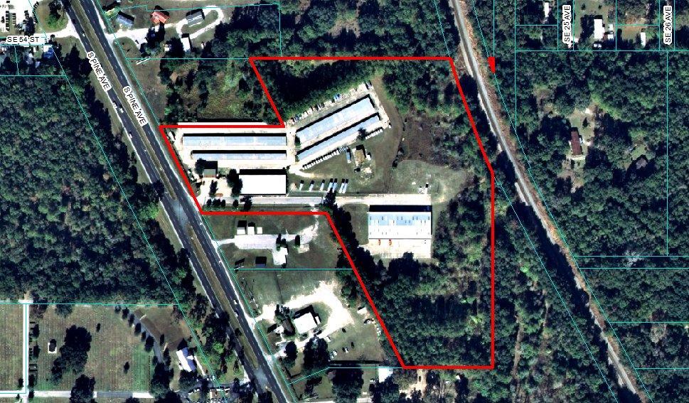
1 OCTOBER 8, 2013 PROJECT NAME: UHAUL S HWY MAJOR SITE PLAN PROJECT NUMBER: APPLICATION: #11903 Met with staff 10/24/13, DRC on 11/4/13 1. DEPARTMENT: ENGDRN - STORMWATER REVIEW REVIEW ITEM: 37. Provide copy of FDEP's Construction Generic Permit (CGP) for NPDES or (NOI). REMARKS: Demonstrate compliance with FDEP s NPDES by providing a copy of the permit or NOI prior to construction. 2. DEPARTMENT: ENGIN - DEVELOPMENT REVIEW REVIEW ITEM: Waivers listed on cover sheet, if applicable. REMARKS: Add waiver conditions and date of approval after DRC. 3. DEPARTMENT: ENGIN - DEVELOPMENT REVIEW REVIEW ITEM: Plans signed by owner & signed and sealed by engineer/surveyor. REMARKS: After approval, plans will be electronically stamped by the county. The applicant will receive an indicating that approved plans are available for download and are located in the eplans project Approved folder. For Development Review submittals, with the exception of Final Plats and Minor Site Plans, applicants are required to print, obtain required signatures, and sign and seal two 24 x 36 sets of the electronically stamped approved plan and deliver them to the Office of County Engineer, Development Review Section, located at 412 SE 25th Avenue Ocala, FL Upon receipt, a development order will be issued. Until such time as that development order is issued, the project does not have final approval and construction, if applicable, shall not commence. For plans requiring As-Builts, As-Builts and associated documentation shall be submitted on paper in accordance with current county requirements. 4. DEPARTMENT: ENGIN - DEVELOPMENT REVIEW REVIEW ITEM: Application fee. REMARKS: The application fee of $ ($5.00 x total site acreage) is due when this plan is resubmitted (if a resubmittal is necessary) made payable to Marion County BCC. Refer to Resolution 10-R-630 for the current fee schedule. Additionally, please include a separate review fee for $40.00 made payable to the Marion County Health Department. 5. DEPARTMENT: UTIL - MARION COUNTY UTILITIES REVIEW ITEM: Comments - No Response Required. REMARKS: No central water or sewer from MCU 6. DEPARTMENT: LUCURR - LAND USE CURRENT REVIEW REVIEW ITEM: Land Use Consistent with Proposed Use & Developer's Agreement? [FLUE Appendix A-5] STATUS OF REVIEW: ENGINEER ACKNOWLEDGED INFO COMMENT REMARKS: The site's existing Future Land Use Designation is Industrial.
2 2 7. DEPARTMENT: LUCURR - LAND USE CURRENT REVIEW REVIEW ITEM: Access Management - Cross/Parallel Access Required? [TE Goal 1A & LDC Section a(2)(e)] STATUS OF REVIEW: ENGINEER ACKNOWLEDGED INFO COMMENT (REFER TO ITEM #30 FOR WAIVER REQUEST) REMARKS: Staff supports the applicant's request for a parallel access waiver to the north, subject to the storage use business, and any future change/redesign/redevelopment in the use would be subject to parallel access requirements effective at that time. 8. DEPARTMENT: LUCURR - LAND USE CURRENT REVIEW REVIEW ITEM: Access Management - Are Sidewalks Provided? [TE Goal 1A & LDC Section a.(1)(d)] STATUS OF REVIEW: ENGINEER ACKNOWLEDGED INFO COMMENT (REFER TO ITEM #29 FOR WAIVER REQUEST) REMARKS: Staff supports the applicant's request for a sidewalk construction waiver along Hwy DEPARTMENT: MANAGEMENT REVIEW ITEM: 15. Addressing STATUS OF REVIEW: ENGINEER ACKNOWLEDGED INFO COMMENT REMARKS: Any addresses for new buildings will be issued at the permitting stage. 10. DEPARTMENT: ENGSUR - SURVEY REVIEW REVIEW ITEM: 2. A signed, sealed and dated boundary and topographic survey of the site meeting Florida Minimum Technical Standards Florida Administrate code (61G17-1) and Florida Statutes Chapter 472, being no more than six months old. STATUS OF REVIEW: ENGINEER ACKNOWLEDGED INFO COMMENT REMARKS: Survey to be signed and sealed upon approval. 11. DEPARTMENT: ENGDRN - STORMWATER REVIEW REVIEW ITEM: 2. Submitted curve numbers reflect the soil conditions in the field. REMARKS: The original approved plans from 1985 have supporting calculations that indicate the 25- year, 24-hour storm event was utilized and that the storage volume required was 270,671 cf, with the DRA providing 284,847 cf. The plans provided today indicate that the DRA storage volume is 204,904 cf. It is acknowledged that the original full build out condition has not occurred; however, modeling calculations are required to demonstrate the generated runoff from the proposed improvements can be supported. Therefore, at this time a full stormwater review cannot be provided and future comments may be generated. (Rate, volume, recovery are unknown) Please provide calculations and call Paul Wildman at for further stormwater discussion. 12. DEPARTMENT: ENGDRN - STORMWATER REVIEW REVIEW ITEM: 3. USGS Quadrangle (Quad) map. REMARKS: Please provide a USGS Quad Map for the area. 13. DEPARTMENT: ENGDRN - STORMWATER REVIEW REVIEW ITEM: 6. Soil Borings are provided a minimum of 10' below the pond bottom and the logs are shown on the construction plans. STATUS OF REVIEW: FURTHER DISCUSSION REQUIRED REMARKS: How will the soil borings be applied to the stormwater analysis? (Borings are not located in the DRA and compaction is proposed under the gravel?
3 3 14. DEPARTMENT: ENGDRN - STORMWATER REVIEW REVIEW ITEM: 7. One boring required for each half acre of pond bottom. STATUS OF REVIEW: STAFF RECOMMENDS APPROVAL OF WAIVER WITH CONDITION OF 3 MORE BORINGS REMARKS: Pending application of stormwater analysis. 15. DEPARTMENT: ENGDRN - STORMWATER REVIEW REVIEW ITEM: 8. One infiltration rate test for each detention/retention facility. STATUS OF REVIEW: STAFF RECOMMENDS APPROVAL OF WAIVER WITH CONDITION OF 1 MORE INFILTRATION REMARKS: Pending application of stormwater analysis. 16. DEPARTMENT: ENGDRN - STORMWATER REVIEW REVIEW ITEM: 9. Watershed Basin boundary line. REMARKS: Please delineate the basins and include all contributing areas. 17. DEPARTMENT: ENGDRN - STORMWATER REVIEW REVIEW ITEM: 10. Time of concentration calculations and show the hydraulic length for each basin. REMARKS: Pending calculations. 18. DEPARTMENT: ENGDRN - STORMWATER REVIEW REVIEW ITEM: 12. Open or closed basin with 100 year or 25year design storms. REMARKS: Pending calculations. 19. DEPARTMENT: ENGDRN - STORMWATER REVIEW REVIEW ITEM: 15. Pond recovers volume in 14 days. REMARKS: Pending calculations. 20. DEPARTMENT: ENGDRN - STORMWATER REVIEW REVIEW ITEM: 16. Private retention/detention pond maintenance sign. STATUS OF REVIEW: STAFF RECOMMENDS APPROVAL OF WAIVER REMARKS: No DRA sign has been identified. Please clarify, provide, or obtain a waiver to this item. Stormwater will support wavier. 21. DEPARTMENT: ENGDRN - STORMWATER REVIEW REVIEW ITEM: 17. Pond detail cross-sections showing DHWL 100yr - 24hr event and the SHGWT. REMARKS: Please provide a DRA cross section that indicates the updated 100 year- 24-hour storm event, the ESHWT, side slopes and stabilization. (DRA may need to be expanded) 22. DEPARTMENT: ENGDRN - STORMWATER REVIEW REVIEW ITEM: 18. Freeboard of six inches for 25 year DHWL. REMARKS: Pending calculations.
4 4 23. DEPARTMENT: ENGDRN - STORMWATER REVIEW REVIEW ITEM: 22. Pipe conveyance calculations 25yr-24hr event with a 25yr-24hr tailwater. REMARKS: Provide conveyance calculations that demonstrate capacity for the 25-year, 24-hour storm event with a 25-year, 24-hour tailwater elevation. 24. DEPARTMENT: ENGDRN - STORMWATER REVIEW REVIEW ITEM: 27. Provide a bedding detail for H.D.P.E. pipe. REMARKS: Please provide a bedding detail for the proposed HDPE. 25. DEPARTMENT: ENGDRN - STORMWATER REVIEW REVIEW ITEM: 28. Innovative design of drainage retention/detention basins waiver reqd d (8). STATUS OF REVIEW: FURTHER DISCUSSION REQUIRED REMARKS: While the plans indicate the intent to utilize 12 #57 gravel as a component of the stormwater system, it is unclear how it will function in totality. Is storage capacity the intent? 26. DEPARTMENT: ENGDRN - STORMWATER REVIEW REVIEW ITEM: 32. Building finished floor elevation is to be 12" above 100 year DHWL (4). REMARKS: Pending calculations. 27. DEPARTMENT: ENGDRN - STORMWATER REVIEW REVIEW ITEM: 35. Provide for construction entrance erosion control. REMARKS: Please provide construction entrance with details or reference. 28. DEPARTMENT: ENGDRN - STORMWATER REVIEW REVIEW ITEM: 39. Springs Protection Elements STATUS OF REVIEW: FURTHER DISCUSSION REQUIRED REMARKS: How will springs protection be addressed? 29. DEPARTMENT: ENGTRF - TRAFFIC REVIEW REVIEW ITEM: a (1) (d) - Sidewalks STATUS OF REVIEW: STAFF RECOMMENDS APPROVAL OF WAIVER REMARKS: 10/7/2013: Sidewalk required unless waiver is obtained. Traffic would support this waiver. 30. DEPARTMENT: ENGTRF - TRAFFIC REVIEW REVIEW ITEM: a (2) - Design Criteria STATUS OF REVIEW: STAFF RECOMMENDS APPROVAL OF WAIVER FOR PARALLEL ACCESS TO THE NORTH. ENGINEER WILL PROVIDE ACCESS TO THE SOUTH. REMARKS: 10/7/2013: Parallel access required to the north and to the south unless waiver is obtained. Traffic would support waiver for parallel access to the north as this is fence off, however parallel access should be provided from access at HWY 441 to the parcel to the south. 31. DEPARTMENT: ENGTRF - TRAFFIC REVIEW REVIEW ITEM: c (1) (m) - Traffic Impact Analysis REMARKS: 10/7/2013: Please provide Traffic statement on cover sheet with the am and pm peak traffic as well as the average daily traffic.
5 5 32. DEPARTMENT: ENGIN - DEVELOPMENT REVIEW REVIEW ITEM: All sheets 24" x 36" and plan identified as "Major Site Plan". REMARKS: Plan not identified as "Major Site Plan". 33. DEPARTMENT: ENGIN - DEVELOPMENT REVIEW REVIEW ITEM: If electronic, appropriate space in upper right hand corner for stamp. REMARKS: Please comply with drawing sheet layout instructions in the Applicant Guide page 13 as follows: When creating each drawing sheet, a blank area shall be reserved for placement of the approval stamp. On all drawing sheets, leave the top right corner completely blank, with exception of the border, for the approval stamp. The approval stamp area shall be portrait oriented, 3 x 5, and located 2-3/4 from right edge of paper and 3/4" from the top edge of paper. 34. DEPARTMENT: ENGIN - DEVELOPMENT REVIEW REVIEW ITEM: Designated area for owner's signature. AND ADD APPROPRIATE STATEMENT REMARKS: 35. DEPARTMENT: FRMSH - FIRE MARSHAL REVIEW REVIEW ITEM: Water system rural or municipal STATUS OF REVIEW: NOT APPLICABLE PER STAFF REMARKS: Need to verify proposed buildings are within 500' of a fire hydrant. Angie Sweeney DEPARTMENT: LUCURR - LAND USE CURRENT REVIEW REVIEW ITEM: Springs Protection Design Required (If YES - ADD SPZ CHECKLIST) REMARKS: Revise the plan to include the following note: "This site is located in the Silver Springs Primary Springs Protection Zone." 37. DEPARTMENT: LUCURR - LAND USE CURRENT REVIEW REVIEW ITEM: Concurrency - If Concurrency Deferral Elected, is election noted on Plan? (TE Goal \1A) REMARKS: Revise the plan to include the following note: "This project has not been granted concurrency approval and/or granted and/or reserved any public facility capacities. Future rights to develop the resulting property(ies) are subject to a deferred concurrency determination, and final approval to develop the property has not been obtained. The completion of concurrency review and/or approval has been deferred to later development review stages, such as, but not limited to, Building Permit review." 38. DEPARTMENT: MANAGEMENT REVIEW ITEM: 10. Correct road names supplied REMARKS: Sheet 01 Civil Cover has several incorrect road names. Road name of N Henderson LN needs to be removed this is a railroad and is not named. Along with the HWY 441 symbol, the designation of S Pine Ave needs to be added. Road name of Buffington Rd is incorrect - the correct designation is SE 52nd St. Road name of SE 55th Lane needs to be removed this is just a driveway and is not named. Sheet 03 Survey, 04 Civil Existing, 05 Civil Overall, 06 Civil Grading, 07 Civil Ph 1 Stormwater, 08 Civil Ph 2 Stormwater, 11 Civil Erosion & 12 Civil Tree all need the road name of SE 55th Lane removed this is just a driveway and is not named.
6 6 39. DEPARTMENT: ENGSUR - SURVEY REVIEW REVIEW ITEM: 3. At least two collinear corners of the site shall be identified and referenced to the Florida State Plane Coordinate System, with datum statement and adjustment noted. REMARKS: State Plane Coordinates, datum and adjustment to shown. 40. DEPARTMENT: ENGSUR - SURVEY REVIEW REVIEW ITEM: 5. The location of all existing structures and site improvements with ties to project boundary. REMARKS: Show ties to building corners from property lines. 41. DEPARTMENT: ENGSUR - SURVEY REVIEW REVIEW ITEM: 7. The location and dimensions of proposed structures and site improvements. REMARKS: Show ties to building corners from property lines. 42. DEPARTMENT: ENGSUR - SURVEY REVIEW REVIEW ITEM: 14. The location and elevation of the 100-year floodplain within the project area with elevation stated. REMARKS: Floodplain not shown or noted. 43. DEPARTMENT: LSCAPE - LANDSCAPE DESIGN AND IRRIGATION REVIEW ITEM: e (1) - Tree locations and tree calculations REMARKS: Due to the phased construction of this site, updated tree calculations are needed. It appears that substantial tree removal is being proposed and the Tree Preservation Plan does not clearly show which trees are to be removed and which trees are to be preserved. If existing trees outside of the current project area are to be used for tree preservation/replacement calculations for the project area, include the total site in the calculations. 44. DEPARTMENT: LSCAPE - LANDSCAPE DESIGN AND IRRIGATION REVIEW ITEM: f (2)(a) - Tree protection barricades REMARKS: Add tree protection detail. Indicate the location of tree protection barricades on the grading plan. 45. DEPARTMENT: LSCAPE - LANDSCAPE DESIGN AND IRRIGATION REVIEW ITEM: g (5) - Remove all invasive species from property REMARKS: Add note on plan stating that all invasive plants must be removed from the site. 46. DEPARTMENT: LSCAPE - LANDSCAPE DESIGN AND IRRIGATION REVIEW ITEM: k - Landscape Plan REMARKS: Provide required Landscape Plan. Additional review comments may be generated upon review of Landscape Plan. 47. DEPARTMENT: LSCAPE - LANDSCAPE DESIGN AND IRRIGATION REVIEW ITEM: k (1)(i) - Irrigation Plan required; minimum requirements Table 8-11 REMARKS: Provide Irrigation Plan. Additional review comments may be generated upon review of Irrigation Plan.
7 7 48. DEPARTMENT: ZONE - ZONING DEPARTMENT REVIEW ITEM: 4. Land use and zoning on project and on adjacent properties shown REMARKS: Please provide the land use and zoning of the subject property as well as the land use and zoning of adjacent properties around the site. 49. DEPARTMENT: ZONE - ZONING DEPARTMENT REVIEW ITEM: 5. Zoning requirements: lot width, area, setbacks, coverage (floor area ratios), and parking REMARKS: Please provide the floor area ratio permitted and proposed for the project. Please also include parking requirements for the property. These can be shown on sheet DEPARTMENT: ZONE - ZONING DEPARTMENT REVIEW ITEM: 8. Acreage of tract to the nearest 0.10 REMARKS: Please provide the acreage of the property on the cover sheet. 51. DEPARTMENT: ZONE - ZONING DEPARTMENT REVIEW ITEM: 9. Date of original and all revisions REMARKS: Please provide the date of the original plan set on all the plans. 52. DEPARTMENT: ZONE - ZONING DEPARTMENT REVIEW ITEM: 10. Setbacks, dimensions for all improvements, and easements (Article 5) REMARKS: Please provide the distances from all structures to the property lines. 53. DEPARTMENT: ZONE - ZONING DEPARTMENT REVIEW ITEM: 12. Tree preservation requirements (Article ) REMARKS: Please identify on the Tree Preservation Plan which trees will be removed. This can be shown by "X" ing out the trees on the plan. 54. DEPARTMENT: ZONE - ZONING DEPARTMENT REVIEW ITEM: 13. Landscape requirements (landscape plan, buffering, (parking lot landscaping) and dumpster screening. REMARKS: A C-type buffer is required along the north property line from the west side of the drainage retention area east to the railroad right of way. A C-type buffer is also required along the southeast property line from the railroad right of way south to the point where the property line runs west. A C-type buffer shall consist of a 15 foot wide landscape strip with at least 5 shade trees for every 100 lineal feet and a hedge planted in double staggered rows and be maintained so as to form a 60-inch high continuous visual screen within two years of planting.
8 UHAUL SELF-STORAGE PID # /24/2013
9 Site Construction Plans of: U-Haul of Ocala RV Expansion DEVELOPER: 5555 S. PINE AVE., OCALA, FLORIDA ENGINEER: SURVEYOR: GEOTECHNICAL: AMERICAN CIVIL ENGINEERING CO. 207 N. Moss Road, Suite 211 Winter Springs, Florida John Herbert, P.E , fax R.M. BARRINEAU & ASSOCIATES, INC SE 25 Loop, Suite 103 Ocala, Florida R.M. Barrineau, P.L.S , fax GEO-TECH, INC S.E. 3rd Avenue Ocala, Florida David Cappa, P.E , fax SITE Site Construction Plans of: U-Haul of Ocala RV Expansion 5555 S. PINE AVE., OCALA, FLORIDA
10 10/3/12 REV. ASPHALT, WET POND 8/17/12 REV. PER SEM. CO. DRC DATE REVISIONS 2 12
11
12 Scale: 1 inch = 60 feet 0' 30' 60' 120' - - DATE REVISIONS 4 12
13 Scale: 1 inch = 60 feet 0' 30' 60' 120' - - DATE REVISIONS 5 12
14 Scale: 1 inch = 60 feet 0' 30' 60' 120' - - DATE REVISIONS 6 12
15 Scale: 1 inch = 60 feet 0' 30' 60' 120' - - DATE REVISIONS 7 12
16 Scale: 1 inch = 60 feet 0' 30' 60' 120' - - DATE REVISIONS 8 12
17 8/17/12 REV. PER SEM. CO. DRC DATE REVISIONS 9 12
18 10/3/12 REV. ASPHALT, WET POND 8/17/12 REV. PER SEM. CO. DRC DATE REVISIONS 10 12
19 Scale: 1 inch = 60 feet 0' 30' 60' 120' - - DATE REVISIONS 11 12
20 J:\12DIST\833\ Ocala at Hwy 441\ construction documents\ inhouse civil\833031_civil0.dwg, 9/12/2013 2:06:16 PM, DWG To PDF.pc A B C D E U-HAUL OF OCALA 5555 S. PINE AVE. OCALA, FL F PRELIMINARY NOT FOR CONSTRUCTION TREE PRESERVATION PLAN SCALE: 1"=30'
DECEMBER 16, Met with staff 12/22/16, DRC on 1/9/17
 DECEMBER 16, 2016 SUBJECT: INITIAL COMMENTS LETTER PROJECT NAME: PHOENIX WOOD PRODUCTS EXPANSION PROJECT #1999007958 APPLICATION: MAJOR SITE PLAN #19606 Met with staff 12/22/16, DRC on 1/9/17 1. DEPARTMENT:
Marion County Board of County Commissioners
 Marion County Board of County Commissioners Office of the County Engineer 412 SE 25th Ave. Ocala, FL 34471 Phone: 352-671-8686 Fax: 352-671-8687 DEVELOPMENT REVIEW COMMITTEE A G E N D A September 16, 2013
SITE PLAN REVIEW APPLICATION AND CHECKLIST
 SITE PLAN REVIEW APPLICATION AND CHECKLIST PROJECT SUMMARY: Project Name: City/ETA Location: City ETA (Application fee & number of copies needed are based on location) Property Location (Legal Description
NOVEMBER 14, 2016 BURRELL ENGINEERING TROY BURRELL N FLORIDA AVE DUNNELLON, FL 34434
 NOVEMBER, 0 BURRELL ENGINEERING TROY BURRELL 005 N FLORIDA AVE DUNNELLON, FL 33 PROJECT NAME: SECO @ SR 00 PROJECT #9990079 APPLICATION: MAJOR SITE PLAN #9388 Dear Troy: The above referenced project was
Marion County Board of County Commissioners
 Marion County Board of County Commissioners Office of the County Engineer 412 SE 25th Ave. Ocala, FL 34471 Phone: 352-671-8686 Fax: 352-671-8687 DEVELOPMENT REVIEW COMMITTEE A G E N D A April 16, 2012
PLANNED UNIT DEVELOPMENT & SUBDIVISION STAFF REPORT Date: May 18, 2017
 & PUD-0000102-2017 PLANNED UNIT DEVELOPMENT & SUBDIVISION STAFF REPORT Date: May 18, 2017 NAME SUBDIVISION NAME Dauphin Creek Estates Subdivision Dauphin Creek Estates Subdivision LOCATION CITY COUNCIL
Checklists. Project Name: Location: File Number: Date of Submittal: Reviewer: Date: Applicant: Contact Name: Phone Number:
 Applicant: Contact Name: Phone Number: Email: Project Name: Location: File Number: Date of Submittal: Reviewer: Date: Concept Plan Requirements: I. General Project Information 1. Address or parcel number
Marion County Board of County Commissioners
 Marion County Board of County Commissioners Office of the County Engineer 412 SE 25th Ave. Ocala, FL 34471 Phone: 352-671-8686 Fax: 352-671-8687 DEVELOPMENT REVIEW COMMITTEE M I N U T E S October 26, 2015
TOWNSHIP OF LOGAN SOIL & FILL IMPORTATION AND PLACEMENT APPLICATION SUBMITTAL CHECKLIST
 TOWNSHIP OF LOGAN SOIL & FILL IMPORTATION AND PLACEMENT APPLICATION SUBMITTAL CHECKLIST Applications: 5 copies of application - Applicant will reproduce the copies at his/her costs. The Township Clerk
THE CITY OF MOBILE, ALABAMA
 THE CITY OF MOBILE, ALABAMA LETTER OF DECISION Ark of Safety, Inc. Mobile, AL 36617 Re: (Northwest corner of Main Street and First Avenue, extending to the Southwest corner of Esau Avenue and Main Street.)
Plat Requirements CHECKLIST FOR SITE PLAN REVIEW
 This checklist is to be used as a guide for complying with the Town of Hollis Site Plan Regulations. It is to be used for each individual site plan review application submitted. Applicants are encouraged
4. Contractor (and subcontractors if applicable) certification statement(s)
 certification statement(s)") CHEMUNG COUNTY STORMWATER COALITION STORMWATER POLLUTION PREVENTION PLAN (SWPPP) SUBMITTAL CHECKLIST GENERAL INFORMATION: 1. Owner/Operator name, legal address, phone number 2. Copy of signed Notice of
CHEMUNG COUNTY STORMWATER COALITION STORMWATER POLLUTION PREVENTION PLAN (SWPPP) SUBMITTAL CHECKLIST GENERAL INFORMATION: 1. Owner/Operator name, legal address, phone number 2. Copy of signed Notice of
SITE PLAN REVIEW ITEMS - REFERENCE CHECKLIST
 City of Seminole 9199 113 th Street N. Seminole, FL 33772 Ph: (727) 392-1966 Fx: (727) 319-6583 SITE PLAN REVIEW ITEMS - REFERENCE CHECKLIST Note: This checklist is designed to aid designers in the review
SUBMITTAL REQUIREMENTS
 WHEN PROCESS TYPE III IS USED References to Process Type III applications are found in several places in the Milton Municipal Code (MMC), indicating that the development, activity, or use, is permitted
Draft Rhode Island Stormwater Design and Installation Standards Manual
 Draft Rhode Island Stormwater Design and Installation Standards Manual Summary The May 2009 Public Review Draft version of the RI Stormwater Design and Installation Standards Manual consists of approximately
Sanford/Lee County Technical Review Committee (TRC) DEADLINES & MEETING DATES
 DEADLINES & MEETING DATES") Sanford/Lee County Technical Review Committee (TRC) DEADLINES & MEETING DATES The following 2019 information is based on the information available to staff at the time of creation. Dates & time may change
Sanford/Lee County Technical Review Committee (TRC) DEADLINES & MEETING DATES The following 2019 information is based on the information available to staff at the time of creation. Dates & time may change
PRELIMINARY CONDITIONAL USE SUBMITTAL CHECKLIST REQUIREMENTS
 This checklist must accompany your submittal as the cover page. CONDITIONAL USE Application Submittal Checklist for PRELIMINARY AND FINAL APPROVAL Per Winter Park Land Development Code Sec. 58-90 PRELIMINARY
City of Waco Stormwater Management Regulations
 1.0 Applicability: City of Waco Stormwater Management Regulations These regulations apply to all development within the limits of the City of Waco as well as to any subdivisions within the extra territorial
PARISH OF ASCENSION OFFICE OF PLANNING AND DEVELOPMENT PLANNING DEPARTMENT. Joint Planning and Zoning Meeting
 1. Call To Order 2. Roll Call of Members 3. Chairman's Comments PARISH OF ASCENSION OFFICE OF PLANNING AND DEVELOPMENT PLANNING DEPARTMENT Joint Planning and Zoning Meeting January 11, 2017 6:00 PM Courthouse
Huntington Stormwater Utility
 Huntington Stormwater Utility Stormwater Management & Sediment and Erosion Control Requirements for Construction Sites Authorized by Huntington City Code Articles: 971, 970, 930, 935, 955, Revised April
Chapter 4 - Preparation of Stormwater Site Plans
 Chapter 4 - Preparation of Stormwater Site Plans The Stormwater Site Plan is the comprehensive report containing all of the technical information and analysis necessary for the City to evaluate a proposed
MOBILE CITY PLANNING COMMISSION LETTER OF DECISION. October 22, 2010
 MOBILE CITY PLANNING COMMISSION LETTER OF DECISION Archbishop of Mobile 400 Government St. Mobile, AL 36602 Re: Case #SUB2010-00075 (Subdivision) 3650 Springhill Avenue (Northwest corner of Springhill
Application for Site Plan Review
 Application for Site Plan Review City of Pontiac Office of Land Use and Strategic Planning 47450 Woodward Ave, Pontiac, MI 48342 T: 248.758.2800 F: 248.758.2827 Property/Project Address: Sidwell Number:
PLANNED DEVELOPMENT (MASTER PLAN & UNIT PLAN)
") Central Permit Center 555 Santa Clara Street Vallejo CA 94590 Business License Building Fire Prevention Planning Public Works 707.648.4310 707.648.4374 707.648.4565 707.648.4326 707.651.7151 PLANNED DEVELOPMENT
Central Permit Center 555 Santa Clara Street Vallejo CA 94590 Business License Building Fire Prevention Planning Public Works 707.648.4310 707.648.4374 707.648.4565 707.648.4326 707.651.7151 PLANNED DEVELOPMENT
CRESCENT RESOURCES INC.
 CRESCENT RESOURCES INC. Due Diligence Checklist Project Name: Client: Project No. Date: 1 Survey Review survey for compliance with Crescent Resources, Inc. s Instructions to Surveyors (see below): All
CITY OF MOBILE MOBILE CITY PLANNING COMMISSION LETTER OF DECISION. November 5, 2012
 SAMUEL L. JONES MAYOR CITY OF MOBILE LETTER OF DECISION OFFICE OF THE CITYCOUNCIL COUNCIL MEMBERS REGGIE COPELAND, SR. PRESIDENT-DISTRICT 5 FREDRICK D. RICHARDSON, JR. VICE PRESIDENT-DISTRICT 1 WILLIAM
Florence County Small Commercial Land Disturbance Permit Application
 Florence County Small Commercial Land Disturbance Permit Application Florence County Engineering Division 518 South Irby Street Florence, S.C. 29501 Phone (843) 676-8600 Fax (843) 676-8667 Tax Map Number:
PLAN SUBMITTER'S CHECKLIST
 Page 1 of 8 PLAN SUBMITTER'S CHECKLIST FOR EROSION AND SEDIMENT CONTROL PLANS Please fill in all blanks and reference the plan sheets/pages where the information may be found, where appropriate, or write
CITY OF ZEELAND PLANNING COMMISSION
 APPLICATION FOR SITE PLAN REVIEW AND SPECIAL LAND USE Date City Official App. Filing Fee Rec'd ($350) NOTE TO APPLICANT: Please submit this application for Site Plan Review along with twenty (20) copies
CITY OF CYPRESS 5275 Orange Avenue Cypress, California (714) DESIGN REVIEW COMMITTEE PERMIT PROCESS
 DESIGN REVIEW COMMITTEE PERMIT PROCESS") CITY OF CYPRESS 5275 Orange Avenue Cypress, California 90630 (714) 229-6720 DESIGN REVIEW COMMITTEE PERMIT PROCESS 1. Discuss project with Planning staff to determine zoning regulations, any unusual characteristics
CITY OF CYPRESS 5275 Orange Avenue Cypress, California 90630 (714) 229-6720 DESIGN REVIEW COMMITTEE PERMIT PROCESS 1. Discuss project with Planning staff to determine zoning regulations, any unusual characteristics
Zoning Ordinance Chapter 10
 CHAPTER 10 - WASHES SECTION 10.0 GENERAL: A. The purpose of this Ordinance is to establish standards for development in or near Major and Minor Washes as defined in Appendix A Glossary of Terms and Definitions
NAPA COUNTY PUBLIC WORKS Standards & Specifications
 Roadway Design & Construction Manual (Table of Contents) 1. Chapter 1: General Provisions 1.1 Short Title 1.2 Jurisdiction 1.3 Purpose and Effect 1.4 Enactment Authority 1.5 Amendment and Revisions 1.6
Department of Planning & Development Planning Unit
 May 20, 2005 Department of Planning & Development Planning Unit Website: www.cityofmadison.com Madison Municipal Building 215 Martin Luther King, Jr. Boulevard P.O. Box 2985 Madison, Wisconsin 53701-2985
SECTION 1 CLEARING /GRADING PERMIT APPLICATION:
 PLEASE REFER TO THE CLEARING & GRADING PERMIT CHECKLIST BELOW FOR SUBMITTAL REQUIREMENTS. SECTION 1 CLEARING /GRADING PERMIT APPLICATION: PROJECT ADDRESS (Street, Suite #): Parcel(s) #: Total Site Area
APPLICATION FOR MINOR SITE PLAN REVIEW
 www.appleton.org APPLICATION FOR MINOR SITE PLAN REVIEW Community and Economic Development Department 100 N. Appleton St. PH: 920-832-6468 Appleton, WI 54911 FAX: 920-832-5994 Stamp date received PROPERTY
Drainage Control Plans
 2016 Drainage Design and Erosion Control Manual - Guide Sheet 1C Drainage Control Plans A Drainage Control Plan is the comprehensive submittal package containing all of the technical information, analysis,
MANUAL OF DESIGN, INSTALLATION, AND MAINTENANCE REQUIREMENTS FOR STORMWATER MANAGEMENT PLANS
 MANUAL OF DESIGN, INSTALLATION, AND MAINTENANCE REQUIREMENTS FOR STORMWATER MANAGEMENT PLANS May 2007 SECTION 1 Responsibility of Applicant TABLE OF CONTENTS A. Stormwater Management Plan Required Information
PLANNED UNIT DEVELOPMENT APPLICATION
 PLANNED UNIT DEVELOPMENT APPLICATION CITY OF THE DALLES Community Development Department 313 Court Street The Dalles, OR 97058 (541) 296-5481, ext. 1125 Fax (541) 298-5490 www.ci.the-dalles.or.us Date
STORMWATER - GENERAL NOTES
 STORM DRAINAGE CONSTRUCTION NOTES. All storm sewer pipe shall be reinforced concrete. 2. Storm drainage pipes shall be a minimum of fifteen (5) inch diameter (5" for short lateral runs only - up to 75
PLANNED UNIT DEVELOPMENT & PLANNING APPROVAL STAFF REPORT Date: April 4, 2013
 PLANNED UNIT DEVELOPMENT & PLANNING APPROVAL STAFF REPORT Date: April 4, 2013 NAME LOCATION The North American Islamic Trust, Inc. 63 East Drive (East side of East Drive, 400 South of Old Shell Road, and
DESIGN CRITERIA PACKAGE
 RFQ: 17-C-00003 DESIGN-BUILD SERVICES FOR THE DESIGN CRITERIA PACKAGE PREPARED BY: JAMES E. JACKSON, JR. AIA CITY ARCHITECT CONTRACT ADMINISTRATION DEPARTMENT and INTERFLOW ENGINEERING, L.L.C DESIGN CRITERIA
LONDONDERRY PLANNING BOARD MINOR SITE PLAN APPLICATION & CHECKLIST
 LONDONDERRY PLANNING BOARD MINOR SITE PLAN APPLICATION & CHECKLIST Planning Department Date Stamp Design Review Formal Application Change of Use (No Site Improvements)* All information provided and submitted
Gloucester County PLAN SUBMITTER'S CHECKLIST
 Page 1 of 9 Gloucester County PLAN SUBMITTER'S CHECKLIST FOR EROSION AND SEDIMENT CONTROL PLANS Please fill in all blanks and please reference the plan sheets/pages where the information may be found,
CHECKLIST FOR PHASE II DRAINAGE REPORT
 I. COVER SHEET CHECKLIST FOR PHASE II DRAINAGE REPORT A. Name of Project B. Address C. Owner D. Developer E. Engineer F. Submittal date and revision dates as applicable II. GENERAL LOCATION AND DESCRIPTION
Appendix I. Checklists
 Appendix I Checklists Town of Greenwich Drainage Manual Department of Public Works - Engineering Division Town Hall - 101 Field Point Road, Greenwich, CT 06836-2540 Phone 203-622-7767 - Fax 203-622-7747
PLANNED UNIT DEVELOPMENT Date: April 5, 2018
 PLANNED UNIT DEVELOPMENT Date: April 5, 2018 DEVELOPMENT NAME SUBDIVISION NAME LOCATION Robert Myers Robert Myers 2955 and 2989 Dauphin Street (Southeast corner of Dauphin Street and Sage Avenue) CITY
CITY PLANNING COMMISSION AGENDA ITEM: C STAFF: ROBERT TEGLER FILE NO: CPC PUD QUASI-JUDICIAL
 CPC AGENDA June 8, 2006 Page 37 CITY PLANNING COMMISSION AGENDA ITEM: C STAFF: ROBERT TEGLER FILE NO: CPC PUD 05-294 - QUASI-JUDICIAL PROJECT: APPLICANT: OWNER: PARKWOOD AT WOLF RANCH NASS DESIGN ASSOCIATES
5. LOW IMPACT DEVELOPMENT DESIGN STANDARDS
 5. LOW IMPACT DEVELOPMENT DESIGN STANDARDS Low Impact Development (LID) requires a shift in stormwater management away from conveying runoff to a small number of downstream points through hydraulically
Drexel, Barrell & Co.
 Drexel, Barrell & Co. December 21, 2018 Engineers/Surveyors Boulder Colorado Springs Greeley 3 South 7 th Street Colorado Springs, Colorado 80905-1501 719 260-0887 719 260-8352 Fax El Paso County Planning
CITY OF TUMWATER 555 ISRAEL RD. SW, TUMWATER, WA (360) (360) (FAX)
 (360) (FAX)") CITY OF TUMWATER 555 ISRAEL RD. SW, TUMWATER, WA 98501 (360) 754-4180 (360) 754-4126 (FAX) Email: cdd@ci.tumwater.wa.us APPENDIX II-C SHORT FORM CONSTRUCTION STORMWATER POLLUTION PREVENTION PLAN (SWPPP)
CITY OF TUMWATER 555 ISRAEL RD. SW, TUMWATER, WA 98501 (360) 754-4180 (360) 754-4126 (FAX) Email: cdd@ci.tumwater.wa.us APPENDIX II-C SHORT FORM CONSTRUCTION STORMWATER POLLUTION PREVENTION PLAN (SWPPP)
PLANNED UNIT DEVELOPMENT & SUBDIVISION STAFF REPORT Date: March 15, 2012
 PLANNED UNIT DEVELOPMENT & SUBDIVISION STAFF REPORT Date: March 15, 2012 DEVELOPMENT NAME SUBDIVISION NAME LOCATION OSR Subdivision OSR Subdivision 5559 Old Shell Road (South side of Old Shell Road, 570
Essential Skills: Reading and Interpreting Maps and Plans
 Essential Skills: Reading and Interpreting Maps and Plans Prepared for: NYS Tug Hill Commission Local Government Conference March 31, 2016 Prepared by: Peter G. Vars, P.E. BME ASSOCIATES Stages of Plan
TO: Glynn County Islands Planning Commission. Karl Bursa, AICP, Planner II. SP3124 Aviator Plaza. DATE: November 17, 2015
 COMMUNITY DEVELOPMENT DEPARTMENT Planning and Zoning Division 1725 Reynolds Street, Suite 200, Brunswick, GA 31520 Phone: 912-554-7428/Fax: 1-888-252-3726 TO: Glynn County Islands Planning Commission MEMO
LONDONDERRY PLANNING BOARD SITE PLAN APPLICATION & CHECKLIST
 LONDONDERRY PLANNING BOARD SITE PLAN APPLICATION & CHECKLIST Planning Department Date Stamp Design Review Formal Application All information provided and submitted with this Application Checklist shall
Northeast Ohio Regional Sewer District Stormwater Management Plan Review Policy
 Northeast Ohio Regional Sewer District Stormwater Management Plan Review Policy Introduction As a component of the Northeast Ohio Regional Sewer District s (District) Regional Stormwater Management Program,
CASE NUMBER: 16SN0701 APPLICANT: Hanky, LLC
 STAFF S ANALYSIS AND RECOMMENDATION Planning Commission (CPC) Public Hearing Date: MAY 17, 2016 CPC Time Remaining: 100 DAYS Applicant s Agent: DANIEL L. CASKIE (804-569-7060) Applicant s Contact: MICHAEL
APPLICATION FOR MINOR SITE PLAN REVIEW
 www.appleton.org APPLICATION FOR MINOR SITE PLAN REVIEW Community and Economic Development Department 100 N. Appleton St. PH: 920-832-6468 Appleton, WI 54911 FAX: 920-832-5994 Stamp date received PROPERTY
Site Development Plan (SDP) Checklist
 Checklist") Development Services Department 100 N. Wilcox Street, Castle Rock CO 80104 303-660-1393 or CRGov.com Site Development Plan (SDP) Checklist A complete Site Development Plan (SDP) submittal will contain
Development Services Department 100 N. Wilcox Street, Castle Rock CO 80104 303-660-1393 or CRGov.com Site Development Plan (SDP) Checklist A complete Site Development Plan (SDP) submittal will contain
SUBMITTAL REQUIREMENTS: FINAL PLAN REVIEW- PROJECT DEVELOPMENT PLAN (PDP)
") 1) Application form and filing fee. Application Form.pdf Development Review Guide STEP 6 of 8 SUBMITTAL REQUIREMENTS: FINAL PLAN REVIEW- PROJECT DEVELOPMENT PLAN (PDP) 2) Transportation Development Review
1) Application form and filing fee. Application Form.pdf Development Review Guide STEP 6 of 8 SUBMITTAL REQUIREMENTS: FINAL PLAN REVIEW- PROJECT DEVELOPMENT PLAN (PDP) 2) Transportation Development Review
Major Subdivision Sketch Plan Checklist
 This checklist provides specific requirements that are apart of the Sketch process. The entire process is described by the Huntersville Subdivision Review Process which details all the submittal and resubmittal
Drexel, Barrell & Co.
 Drexel, Barrell & Co. June 18, 2018 Engineers/Surveyors Boulder Colorado Springs Greeley 3 South 7 th Street Colorado Springs, Colorado 80905-1501 719 260-0887 719 260-8352 Fax El Paso County Planning
HILLSIDE BUILDING COMMITTEE PLAN REVIEW DIRECTIONS
 HILLSIDE BUILDING COMMITTEE PLAN REVIEW DIRECTIONS 1 1. Review Hillside Regulations to ensure your design is in conformance with current Town Code. 2. Complete page 3 and contact Paul Mood at 480-348-3573,
City of Mt. Juliet Planning & Zoning Department. Site Plan Checklist. Site plan cklist v1.18
 City of Mt. Juliet Planning & Zoning Department Site Plan Checklist Site Plan approval is required for all specified community facilities, all commercial, industrial, and multi-family residential activities
City of Sun Prairie Wetland Buffer Reduction Request
 City of Sun Prairie Wetland Buffer Reduction Request Westside Development Area January 9, 2017 Prepared by: City of Sun Prairie 300 E. Main Street Sun Prairie, WI 53590 BACKGROUND The City of Sun Prairie
UNIVERSITY PRESBYTERIAN CHURCH - RENOVATION & ADDITION 209 EAST FRANKLIN ST., CHAPEL HILL, NC 27514
 UNIVERSITY PRESBYTERIAN CHURCH - RENOVATION & ADDITION 209 EAST FRANKLIN ST., CHAPEL HILL, NC 27514 PROJECT DATA OVERALL SITE MAP HDC CONCEPT PLAN SUBMITTAL: OCT. 8, 2012 SUP SUBMITTAL: MAY 28, 2013 SUP
D1 September 11, 2013 Public Hearing APPLICANT:
 D1 September 11, 2013 Public Hearing APPLICANT: BEACH MUNICIPAL FEDERAL CREDIT UNION PROPERTY OWNER: SISTERS II, LLC STAFF PLANNER: Karen Prochilo REQUEST: Conditional Change of Zoning (AG-2 Agriculture
APPLICATION FOR REZONING PROPERTY CITY OF HOLLAND, MICHIGAN. Name of Applicant. Address, and Phone # of Applicant
 APPLICATION FOR REZONING PROPERTY CITY OF HOLLAND, MICHIGAN Name of Applicant Address, Email and Phone # of Applicant Name and Address of Owner (if other than applicant) Ownership Interest of Applicant
Washington County, Maryland Division of Public Works Policy Manual
 Washington County, Maryland Division of Public Works Policy Manual Subject: Downstream Drainage Easement Category: Land Development Engineering Number: 7-4.1 Date: June 1, 2009 (effective) PURPOSE: The
APPLICATION FORM SITE PLAN REVIEW REGULATIONS TOWN OF CONWAY, NH
 February 25, 2010 INSTRUCTIONS APPLICATION FORM SITE PLAN REVIEW REGULATIONS TOWN OF CONWAY, NH Please complete each section of this application from and submit it with all required application material
Major Development Order Approval Process. Introduction. In This Handout. Pre-Application Meeting. Meetings
 Approval Process Introduction 1CITY OF MARIANNA MUNICIPAL DEVELOPMENT DEPARTMENT Post Office Box 936 Marianna, FL 32447 (850) 482-2786 Fax (850) 482-3627 The City of Marianna requires developers obtain
RESIDENTIAL PLANNED UNIT DEVELOPMENT / SUBDIVISION AND REZONING CONCEPT AND DEVELOPMENT STAGE PLAN SUBMITTAL NARRATIVE
 RESIDENTIAL PLANNED UNIT DEVELOPMENT / SUBDIVISION AND REZONING CONCEPT AND DEVELOPMENT STAGE PLAN SUBMITTAL NARRATIVE DEVELOPMENT TEAM DONEGAL SOUTH Maple Grove, Minnesota March 27, 2017 Applicant/Developer/Builder:
Section 11 Grading and Drainage Standards
 Section 11 Grading and Drainage Standards 11.1 INTRODUCTION The proper grading, conveyance, storage and release of storm water is critical to maintain the integrity of the Property. Drainage facilities,
Neo-Traditional Overlay Application
 MAYOR AND CITY COUNCIL OF LAUREL DEPARTMENT OF ECONOMIC AND COMMUNITY DEVELOPMENT 8103 Sandy Spring Road Laurel, Maryland 20707 (301) 725-5300 Internet Address http://www.cityoflaurel.org E-mail: ecd@laurel.md.us
Town of West Point Plan of Development
 Town of West Point Plan of Development Plan Submission In accordance with Section 70-51(b) of the Town Code, the Zoning Administrator shall establish a written policy for the form, format, content and
Staff Report Bourbon County Joint Planning Office SPECIAL MEETING September 4, 2018
 Staff Report Bourbon County Joint Planning Office SPECIAL MEETING September 4, 2018 Case Number: DVP 18-05 FINAL Applicant: Josh Cummins Location: Arlington Drive. Request: Car Dealer Parking Lot Zoning:
Site Plan Review Residential Accessory Building
 COMMUNITY DEVELOPMENT DEPARTMENT Planning Division P.O. Box 490 333 Broadalbin Street SW Albany, OR 97321 Phone (541) 917-7550 Fax (541) 917-7598 www.cityofalbany.net Site Plan Review Residential Accessory
Mayor Leon Skip Beeler and Members of the City Commission. Anthony Caravella, AICP, Director of Development Services
 CITY COMMISSION BRIEFING & Planning Board Report For Meeting Scheduled for June 7, 2012 Inner Room Cabaret Site Plan/Architectural Review Downtown Overlay District/Primary Downtown Area Site Plan Consent
ANNE ARUNDEL COUNTY OFFICE OF PLANNING AND ZONING - DEVELOPMENT DIVISION. Site Development Plan Submittal Application Requirements
 ANNE ARUNDEL COUNTY OFFICE OF PLANNING AND ZONING - DEVELOPMENT DIVISION Site Development Plan Submittal Application Requirements Project Name: Project Site Plan # C: Date: Instructions: All submissions
Project Applicant Checklist for NPDES Permit Requirements SAN MATEO COUNTYWIDE STORMWATER POLLUTION PREVENTION PROGRAM
 Project Applicant Checklist for NPDES Permit Requirements SAN MATEO COUNTYWIDE STORMWATER POLLUTION PREVENTION PROGRAM I. PROJECT DATA Project Name Bay Meadows Development Phase II Project Address 2600
MASTER DEVELOPMENT DRAINAGE PLAN FOR MONUMENT HEIGHTS
 MASTER DEVELOPMENT DRAINAGE PLAN FOR MONUMENT HEIGHTS DRAINAGE REPORT STATEMENT ENGINEER'S STATEMENT: The attached drainage plan and report were prepared under my direction and supervision and are correct
Preliminary Subdivision Plan/ Site Development Order/Final Engineering Application
 Development Review Division Development Services Department CITY OF OVIEDO 400 Alexandria Boulevard Oviedo, Florida 32765 Application No. Date Received Phone: (407) 971-5775 Fax: (407) 971-5819 www.cityofoviedo.net
SITE PLAN REVIEW APPLICATION
 SITE PLAN REVIEW APPLICATION CITY OF THE DALLES Community Development Department 313 Court Street The Dalles, OR 97058 (541) 296-5481, ext. 1125 Fax (541) 298-5490 www.ci.the-dalles.or.us Date Filed File#
Article 20 Stormwater Management
 Article 20 Section 20.01 Intent Article 20 The purpose of this Article is to protect the health, safety, and general welfare of the citizens by requiring compliance with accepted standards and practices
Gadsden County Planning Commission Agenda Request
 Date of Meeting: November 16, 2017 To: From: Through: Subject: Gadsden County Planning Commission Agenda Request Honorable Chairperson and Members of the Board Jill A. Jeglie, AICP, Senior Planner Clyde
APPLICATION SUBMITTAL CHECKLIST LAND USE PERMITS
 730 33rd Avenue NE Woodinville, WA 98072 SEPA/Project Approval Critical Area Determination Critical Area Alteration/ Exception/ Reasonable Use Design Review Application Form Owner Authorization Form Project
CITY-COUNTY PLANNING BOARD DRAFT STAFF REPORT
 CITY-COUNTY PLANNING BOARD DRAFT STAFF REPORT PETITION INFORMATION Docket # W-3174 Staff Aaron King Petitioner(s) O Reilly Auto Parts Owner(s) Glenn Crossing Associates, LLC Subject Property Portion of
ARTICLE 6: Special and Planned Development Districts
 ARTICLE 6: Special and Planned Development Districts 6-10 Traditional Neighborhood Development (TND) District 6-10.10 Purpose and Intent The Traditional Neighborhood Development (TND) District provides
ST. MARY S SOIL CONSERVATION DISTRICT (SMSCD) AND DPW&T CONCEPT EROSION AND SEDIMENT CONTROL AND STORMWATER MANAGEMENT GUIDELINES AND CHECKLIST
 AND DPW&T CONCEPT EROSION AND SEDIMENT CONTROL AND STORMWATER MANAGEMENT GUIDELINES AND CHECKLIST") St. Mary s Soil Conservation District 26737 Radio Station Way, Suite B Leonardtown, MD 20650 Phone: 301-475-8402 ext. 3 Fax: 301-475-8391 www.stmarysscd.com St. Mary s County Government Department of Public
St. Mary s Soil Conservation District 26737 Radio Station Way, Suite B Leonardtown, MD 20650 Phone: 301-475-8402 ext. 3 Fax: 301-475-8391 www.stmarysscd.com St. Mary s County Government Department of Public
Pond Siting Report Update
 Pond Siting Report Update Prepared for: Florida Department of Transportation District 5 CR 46A Realignment from SR 46 to North of Arundel Way Lake County, Florida FPID No. 238275-8-32-02 October 2013 (Draft
PCE PRELIMINARY DRAINAGE ANALYSIS REPORT FOR WESTWOOD MIXED USE NEIGHBORHOOD PROJECT 772 NORTH FOREST ROAD TOWN OF AMHERST, ERIE COUNTY, NEW YORK
 PCE PRELIMINARY DRAINAGE ANALYSIS REPORT FOR WESTWOOD MIXED USE NEIGHBORHOOD PROJECT 772 NORTH FOREST ROAD TOWN OF AMHERST, ERIE COUNTY, NEW YORK MAY 19, 2014 Prepared By: Timothy M. Lavocat, P.E., CFM
Project phasing plan (if applicable) 12 copies of site plan
 12 copies of site plan") SITE PLAN REVIEW PERMIT APPLICATION City of Grand Haven, 11 N. Sixth Street, Grand Haven, MI 49417 Phone: (616) 847-3490 Fax: (616) 844-2051 Website: www.grandhaven.org 1. Project Information Address/location
SITE PLAN REVIEW PERMIT APPLICATION City of Grand Haven, 11 N. Sixth Street, Grand Haven, MI 49417 Phone: (616) 847-3490 Fax: (616) 844-2051 Website: www.grandhaven.org 1. Project Information Address/location
PRELIMINARY PLAT DESIGN REQUIREMENTS Updated 4/8/2016
 PRELIMINARY PLAT DESIGN REQUIREMENTS Updated 4/8/2016 The following items are required for the preliminary plat. Numbers correspond with those on the example preliminary plat. RENO COUNTY SUBDIVISION REQUIREMENTS
Project: Developer/Designer: Reviewer: I. Narrative: 1. Project Description: Describes the nature and purpose of the land disturbing activity.
 City of Charlottesville, Virginia Erosion and Sediment Control Plan Review Checklist 610 East Market Street, Charlottesville, VA 22902 Telephone 434-970-3182; Fax 434-970-3359 Project: Developer/Designer:
SUPPORTING DOCUMENT STORMWATER POLLUTION PREVENTION PLAN (SWPPP) NARRATIVE
 NARRATIVE") SUPPORTING DOCUMENT STORMWATER POLLUTION PREVENTION PLAN (SWPPP) NARRATIVE Please complete this narrative form and submit with your SWPPP drawings. Refer to Kitsap County Stormwater Design Manual Vol.
SUPPORTING DOCUMENT STORMWATER POLLUTION PREVENTION PLAN (SWPPP) NARRATIVE Please complete this narrative form and submit with your SWPPP drawings. Refer to Kitsap County Stormwater Design Manual Vol.
PART 1: PROJECT SUMMARY. Proposed Land Use: 120 single-family lots. The application is Attachment A. The site plan is Attachment B.
 PART 1: PROJECT SUMMARY Applicant: JBH Development, LLC and Hopper Communities, INC Project Size: +/- 80.48 acres Parcel Number: 01513107, 01513108, 01513109, 01513113, 01513120, 01513121, 01513122, 01513124,
CITY OF KEIZER MASTER PLAN APPLICATION & INFORMATION SHEET
 CITY OF KEIZER MASTER PLAN APPLICATION & INFORMATION SHEET PRE-APPLICATION CONFERENCE Prior to the actual filing of a Master Plan application, it is strongly recommended that the applicant contact Planning
PLANNING AND DEVELOPMENT DEPARTMENT SITE PLAN REVIEW SECTION / CURRENT PLANNING APPLICATION FOR PRELIMINARY SITE DEVELOPMENT PLAN APPROVAL
 PLANNING AND DEVELOPMENT DEPARTMENT SITE PLAN REVIEW SECTION / CURRENT PLANNING APPLICATION FOR PRELIMINARY SITE DEVELOPMENT PLAN APPROVAL Project Number City Development Number Application Date (Assigned
Net Land Area (NLA): Area within zoning lot boundaries NLA= sq. ft. a) Credited Street Area (total adjacent frontage) x ½ width of public rightof-way
: Area within zoning lot boundaries NLA= sq. ft. a) Credited Street Area (total adjacent frontage) x ½ width of public rightof-way") PROJECT FACT SHEET Section A: Project Information Application type: Date: Project Name: Use Type: (check/list all that apply) Office/Institutional Residential Mixed-Use Other: Overlay District: (check
PROJECT FACT SHEET Section A: Project Information Application type: Date: Project Name: Use Type: (check/list all that apply) Office/Institutional Residential Mixed-Use Other: Overlay District: (check
COLUMBIA COUNTY LAND DEVELOPMENT SERVICES COURTHOUSE 230 STRAND ST. HELENS, OREGON (503) General Application
 General Application") General Application COLUMBIA COUNTY LAND DEVELOPMENT SERVICES COURTHOUSE 230 STRAND ST. HELENS, OREGON 97051 (503) 397-1501 File No. GENERAL LAND USE PERMIT APPLICATION TYPE OF PERMIT: Zone Change Temporary
General Application COLUMBIA COUNTY LAND DEVELOPMENT SERVICES COURTHOUSE 230 STRAND ST. HELENS, OREGON 97051 (503) 397-1501 File No. GENERAL LAND USE PERMIT APPLICATION TYPE OF PERMIT: Zone Change Temporary
ENGINEERS AND SURVEYORS INSTITUTE A public/private partnership CITY OF ALEXANDRIA, VIRGINIA MINIMUM SUBMISSION REQUIREMENTS SITE PLAN
 ENGINEERS AND SURVEYORS INSTITUTE A public/private partnership CITY OF ALEXANDRIA, VIRGINIA MINIMUM SUBMISSION REQUIREMENTS SITE PLAN PROJECT NAME: PROJECT ADDRESS: TAX MAP REFERENCES: ENGINEER: E-MAIL: