Report Date: April 24, 2014 Contact: Kent Munro Contact No.: RTS No.: VanRIMS No.: Meeting Date: May 13, 2014
|
|
|
- Elijah Dixon
- 5 years ago
- Views:
Transcription

1 POLICY REPORT DEVELOPMENT AND BUILDING Report Date: April 24, 2014 Contact: Kent Munro Contact No.: RTS No.: VanRIMS No.: Meeting Date: May 13, 2014 TO: FROM: SUBJECT: Vancouver City Council General Manager of Planning and Development Services CD-1 Rezoning: 1551 Quebec Street, 1600 Ontario Street and 95/99 East 1st Avenue (Southeast False Creek Areas 3A and 3B) RECOMMENDATION A. THAT the application, by Rafii Architects Inc. on behalf of Concert Real Estate Corporation (Concert Properties) and the City of Vancouver, to rezone: 1551 Quebec Street [PID: ; Lot 5, Except Part in Reference Plan Now Road, Block E, District Lots 200A and 2037, Plan 12958]; 1600 Ontario Street [PID: ; Lot 307, Except: Part on Plan BCP20721 False Creek Plan BCP20720]; and 95/99 East 1st Avenue [PID: ; Lot 1, Block E, District Lot 200A, Plan 12958]; from M-2 (Industrial) District to CD-1 (Comprehensive Development) District to allow 58,020 m² (624,525 sq. ft.) of residential development in five buildings including a 9,748 m² (104,925 sq. ft.) social housing building, be referred to a Public Hearing, together with: (i) plans prepared by Rafii Architects Inc., received August 1, 2013; (ii) draft CD-1 By-law provisions, generally as presented in Appendix A; (iii) draft CD-1 Design Guidelines, generally as presented in Appendix F; and (iv) the recommendation of the General Manager of Planning and Development Services to approve, subject to conditions contained in Appendix B; FURTHER THAT the Director of Legal Services be instructed to prepare the draft by-law generally in accordance with Appendix A for consideration at Public Hearing.
2 CD-1 Rezoning: 1551 Quebec Street, 1600 Ontario Street, and 95/99 East 1st Avenue (Southeast False Creek Areas 3A and 3B) RTS B. THAT, if the application is referred to a Public Hearing, consequential amendments to Areas 3A and 3B in the Southeast False Creek Official Development Plan (By-law No. 9073) to increase various floor area provisions by 10,765 m 2 and to increase the maximum permitted building height from m to m as set out in Appendix C, also be referred to the same Public Hearing and be approved, subject to the Public Hearing; FURTHER THAT the Director of Legal Services be instructed to prepare the necessary amending by-law generally in accordance with Appendix C for consideration at the Public Hearing. C. THAT, at the time of enactment of the CD-1 By-law, the General Manager of Development Services be instructed to bring forward for approval the CD-1 Design Guidelines, generally as presented in Appendix F. D. THAT Recommendations A to C be adopted on the following conditions: (i) (ii) (iii) THAT the passage of the above resolutions creates no legal rights for the applicant or any other person, or obligation on the part of the City; any expenditure of funds or incurring of costs is at the risk of the person making the expenditure or incurring the cost; THAT any approval that may be granted following the Public Hearing shall not obligate the City to enact a bylaw rezoning the property, and any costs incurred in fulfilling requirements imposed as a condition of rezoning are at the risk of the property owner; and THAT the City and all its officials, including the Approving Officer, shall not in any way be limited or directed in the exercise of their authority or discretion, regardless of when they are called upon to exercise such authority or discretion. REPORT SUMMARY This report evaluates an application to rezone the properties at 1551 Quebec Street, 1600 Ontario Street, and 95/99 East 1st Avenue, the rezoning site, together identified as Areas 3A and 3B in the Southeast False Creek Official Development Plan (SEFC ODP), from M-2 (Industrial) District to CD-1 (Comprehensive Development) District to permit the phased development of five residential buildings with a total floor area of 58,020 m² (624,525 sq. ft.). The application proposes refinements to the initial scheme presented in the Illustrative Plan contained within the SEFC ODP. Those refinements include a building form which better responds to recently approved developments east of the rezoning site along Quebec Street, improved configuration of the proposed park space and construction of a 137 unit social housing building in the first phase of development. The proposal requires that the SEFC ODP development potential of Area 3A, owned by the City, be consolidated with Area 3B, owned by Concert Properties, achieving a more cohesive site plan. If approved, the majority of the additional density would be used for social housing, and the value generated from additional market residential density would finance approximately 30% of its construction cost.
3 CD-1 Rezoning: 1551 Quebec Street, 1600 Ontario Street, and 95/99 East 1st Avenue (Southeast False Creek Areas 3A and 3B) RTS Staff have assessed the application and support the use, density and form of development, subject to design development and other conditions outlined in Appendix B. Staff recommend that the application be referred to a Public Hearing, with the recommendation of the General Manager of Planning and Development Services to approve it, subject to the Public Hearing. Figure 1 Rezoning Site, Surrounding Zoning and Notification Area COUNCIL AUTHORITY/PREVIOUS DECISIONS Relevant Council policies for this rezoning site include: Southeast False Creek Official Development Plan By-law (enacted July 2005 and last amended October 2012) Southeast False Creek Financial Plan and Strategy (March 2005) Southeast False Creek Public Benefits Strategy and Compatible Housing Strategy (June 2006) Southeast False Creek Green Building Strategy (adopted July 2004 and amended July 2008) Southeast False Creek Design Guidelines for Additional Penthouse Storeys (July 20, 2010) Southeast False Creek Public Realm Plan (July 20, 2006) Public Art Policies and Guidelines (2008) High-Density Housing for Families with Children Guidelines (1992) Green Buildings Policy for Rezoning (2010) Rezoning Policy for Sustainable Large Developments (2013)
4 CD-1 Rezoning: 1551 Quebec Street, 1600 Ontario Street, and 95/99 East 1st Avenue (Southeast False Creek Areas 3A and 3B) RTS Community Amenity Contributions Through Rezonings (2011) Housing and Homelessness Strategy (2011) REPORT Background/Context Site and Context This 2.6 ha (6.4 acre) rezoning site is located at the northwest corner of Quebec Street and 1st Avenue and is bounded by the False Creek seawall to the north and Ontario Street to the west. The rezoning site comprises all of Areas 3A and 3B as defined in the Southeast False Creek Official Development Plan (SEFC ODP) combining the remaining vacant land between the Olympic Village and the lands currently under development on the east side of Quebec Street. The entire rezoning site is currently vacant and paved for temporary use as a parking facility. To the north, the seawall rounds the east end of False Creek between Science World and its surface parking lot fronting Quebec Street. To the west, the Olympic Village site has been fully developed with residential buildings up to 13 storeys in height along Ontario Street, with the new two-storey Creekside Community Centre operating on the waterfront. Properties across Quebec Street to the east have recently been rezoned under the SEFC ODP as mixed use developments with commercial uses fronting Main Street and residential units along Quebec Street. Heights of buildings under construction range from 15 storeys near 1st Avenue rising to 18 and 19 storeys further north. On 1st Avenue to the south are three- and fourstorey industrial-commercial buildings. A development site at the southeast corner of 1st Avenue and Ontario Street has been rezoned to CD-1 allowing the development of a 17-storey residential building. Figure 2 provides a plan identifying the building heights proposed by the application and the approved and anticipated building heights in areas surrounding the rezoning site. The rezoning site benefits from a well-developed network of pedestrian connections to the Olympic Village, the seawall and the False Creek ferry stop at the foot of Ontario. Exceptional cycling connections are provided by well-used bike routes along the waterfront to the north and west, along Ontario Street to the south and along the Central Valley Greenway to the east. Transit connections within a two-block walk include the SkyTrain station at Main Street and Terminal Avenue, and bus stops on Main Street and on 2nd Avenue.

5 CD-1 Rezoning: 1551 Quebec Street, 1600 Ontario Street, and 95/99 East 1st Avenue (Southeast False Creek Areas 3A and 3B) RTS Figure 2 Context with Proposed Building Heights in Number of Storeys Background Concert Properties purchased the majority of the property in Area 3B in 2011 and engaged City staff in discussions regarding opportunities to improve upon what was planned for Areas 3A and 3B in the SEFC ODP, while continuing to embrace the objectives of the ODP. With the adoption of SEFC Design Guidelines for Additional Penthouse Storeys in 2010, taller developments have been approved for sites immediately adjacent creating an evolving higher density context. The rezoning application reflects collaboration with staff seeking to create a more cohesive site plan for Area 3A and 3B with improved and expanded park space. Added density enables the immediate construction of social housing on site without requirement of senior government funding. The City is entering into an agreement with Concert Properties, subject to approval of the rezoning application, to construct a social housing building with a minimum of 133 dwelling units in the first phase of the development. The current application shows 137 social housing units.
 The SEFC ODP envisioned the transformation of underutilized industrial waterfront land into a high-density, predominantly residential neighbourhood, demonstrating the City s ability to")
6 CD-1 Rezoning: 1551 Quebec Street, 1600 Ontario Street, and 95/99 East 1st Avenue (Southeast False Creek Areas 3A and 3B) RTS Policy Context Southeast False Creek Official Development Plan (SEFC ODP) The SEFC ODP envisioned the transformation of underutilized industrial waterfront land into a high-density, predominantly residential neighbourhood, demonstrating the City s ability to move significantly towards more sustainable development practices. It seeks to encourage vitality, diversity, and cultural richness in a manner that respects the history and context of the area. The SEFC ODP provides the framework to create a complete community, which we now see anchored by the Olympic Village and many surrounding sites which have been developed since the adoption of the SEFC ODP in The ODP is divided into the Areas identified in Figure 3. The rezoning site includes all of the land in Areas 3A and 3B, east of the Olympic Village to Quebec Street. Many of the privately owned lands in Areas 1B, 2B and 3C have been developed, as has the Olympic Village (Area 2A). See figure 4. Figure 3. Southeast False Creek ODP Areas

7 CD-1 Rezoning: 1551 Quebec Street, 1600 Ontario Street, and 95/99 East 1st Avenue (Southeast False Creek Areas 3A and 3B) RTS Figure 4 - Aerial photo of rezoning site, showing surrounding development Southeast False Creek Design Guidelines for Additional Penthouse Storeys Following the development of the Olympic Village in 2010, Council recognized an opportunity for the developers of the privately owned lands within SEFC to contribute further towards public benefits (e.g. housing affordability, heritage), and directed staff to develop a policy approach for increases in building height. The resulting policy supports up to two additional partial penthouse stories, and commensurate density, on buildings in certain areas within SEFC, including Areas 3A and 3B. Rezoning Policy for Sustainable Large Developments This policy aims to achieve higher sustainability outcomes on large-site developments with a site area over 8,000 m 2 (1.98 acres) by considering opportunities for low-carbon heat, sustainable site design, green mobility and clean vehicles, sustainable rainwater management, enhanced solid-waste diversion, and greater housing affordability and mix. This requirement builds further on the sustainability requirements applied generally to SEFC development. The rezoning application includes a detailed sustainability strategy (see discussion in the Environmental Sustainability section). Strategic Analysis 1. Proposal The coordinated development of Areas 3A and 3B provides an opportunity to optimize the configuration of park and public realm spaces, while accommodating additional building height and density providing for the development of a social housing building in the first phase of construction. The plan includes five residential buildings, including the social housing building, a new street and lane, and over 1.1 ha (2.7 acres) of park. The proposed buildings range in height from 12 to 18 storeys with a total floor area of 58,020 m 2 (624,525 sq. ft.), equivalent to 3.51 FSR, as calculated on 1.7 ha (4.1 acres), net of the City-owned land to be retained as park. Development of the rezoning site would happen in three phases as illustrated in Figure 5. The social housing building would also accommodate two in-home daycare units at grade level.
8 CD-1 Rezoning: 1551 Quebec Street, 1600 Ontario Street, and 95/99 East 1st Avenue (Southeast False Creek Areas 3A and 3B) RTS Figure 5 Phasing Plan with Building Numbers 2. Land Use The SEFC ODP specifies that a substantial portion of Area 3A be developed as park and that at least 20% of the residential units be available for social housing. Only residential use is supported in Area 3A. Area 3B is to be predominantly residential with a requirement to dedicate approximately 0.18 ha of park land to be consolidated with the adjacent large park on Area 3A. The SEFC ODP provides an option to consider, during the rezoning process, retail and service uses in Area 3B at grade along the Quebec Street or 1 st Avenue frontages. No commercial uses are proposed in this application. With new commercial space developing one block to the east on Main Street and one block to the west at Manitoba Street, and considering the residential character developing on Quebec Street, staff support the residential uses proposed on the rezoning site. The social housing requirement is discussed later in the Housing section of this report.
 for Area 3A and 30,485 m 2 (328,140 sq. ft.) for Area 3B, for a total of 47,255 m 2 (508,652 sq. ft.). The application proposes a total floor area of 58,020 m 2 (624,525 sq.")
9 CD-1 Rezoning: 1551 Quebec Street, 1600 Ontario Street, and 95/99 East 1st Avenue (Southeast False Creek Areas 3A and 3B) RTS Density The SEFC ODP prescribes a floor area of 16,770 m 2 (180,512 sq. ft.) for Area 3A and 30,485 m 2 (328,140 sq. ft.) for Area 3B, for a total of 47,255 m 2 (508,652 sq. ft.). The application proposes a total floor area of 58,020 m 2 (624,525 sq. ft.). The SEFC Guidelines for Additional Penthouse Storeys support additional height and commensurate density on the rezoning site to achieve public benefits while respecting the original intent of the SEFC ODP. The proposed additional floor area of 10,765 m 2 (115,873 sq. ft.) results in an effective FSR of 3.51, calculated on 1.7 ha (4.1 acres), net of the City-owned land to be retained as park. This is equivalent to density initially supported by the SEFC ODP in adjacent Areas 2B and 3C. With densities approved under the SEFC Guidelines for Additional Penthouse Storeys ranging from 3.65 to 5.03 FSR in the adjacent areas, the density proposed maintains the intended transition to the park and waterfront. 4. Height and Form of Development Three buildings, Buildings 3 and 4 on the western edge and Building 1 on the southeast corner, generally meet the height and form of development expectations delineated by the SEFC ODP and the SEFC Guidelines for Additional Penthouse Storeys. The tower height for Building 2 is proposed to increase in anticipated height from 11 to 15 storeys, which staff consider appropriate, taking into consideration the approved built forms for the properties located to the east, which have also achieved building heights above the original intentions of the ODP, while delivering additional public benefits. Figure 6 Proposed Building Heights (Shown in Storeys)
10 CD-1 Rezoning: 1551 Quebec Street, 1600 Ontario Street, and 95/99 East 1st Avenue (Southeast False Creek Areas 3A and 3B) RTS The north building, Building 5, proposes an additional five storeys or 9.0 m (29.5 ft.) in overall height, but its tower has been relocated to the northernmost location of the rezoning site to maximize the spacing distance from the Building 2 tower. The wider spacing between these towers offers improved private views through the rezoning site towards False Creek for the residences located east of Quebec Street. Furthermore, due to the increase in building height, staff have required, in the CD-1 Design Guidelines (Appendix F), that Building 5 achieve an exceptional design aesthetic so that it achieves a notable and prominent landmark status, adding to the overall visual amenity in the neighbourhood. To maximize the westward views through the rezoning site from the properties located to the east, all three tower forms for Quebec-fronting buildings (Buildings 1, 2 and 5) would be oriented in an east-west direction, thereby creating generous gaps between the towers of approximately 55 m (180 ft.). 5. East Park Approximately ha (25.8 acres) of total park area is planned for SEFC, the majority of which (10.28 ha) is to be located in the waterfront Areas 1A, 2A and 3A. These lands were City-owned at the time the SEFC ODP was adopted, and some flexibility in the distribution and detailed planning of the park space was provided for in the ODP requirement. The only privately owned site with a park space requirement is Area 3B, which must dedicate approximately 0.18 ha (0.44 acre) to the development of East Park. Based on the SEFC Illustrative Plan, the total area of East Park is to be approximately 1.1 ha (2.7 acres). The improved site plan proposed for Areas 3A and 3B results in a park area of slightly over 1.1 ha. If the rezoning is approved by Council, the land would be set aside for park and Park Board staff would subsequently undertake a full park planning process to determine the physical design of the park. While the detailed design and development of East Park is not included in this rezoning application, the shape and area of the park has been determined. The proposed park shape improves upon the SEFC Illustrative Plan by providing a better visual connection to 1st Avenue, inviting the public to access the park and the waterfront beyond. To mitigate negative impacts from construction and to involve new residents in the park programing consultation process, the park would be constructed once the buildings adjacent to the park are completed in phases two and three, at the discretion of the Parks Board subject to approval through the Capital Plan and Budget process. 6. Housing The SEFC ODP requires that a minimum of 20% of residential units on City-owned lands in Areas 1A, 2A and 3A, are designed to be Affordable Housing. The ODP defines Affordable Housing as accommodating households with incomes below BC Housing s Housing Income Limits or HILs. The SEFC ODP also includes a requirement of 33% of total units in areas 1A and 3A to be Modest Market housing. The ODP defines Modest Market as housing that is affordable to the middle third of incomes for the Greater Vancouver region. According to the Statistics Canada 2011 National Household Survey, the middle third of incomes for the region reflects a range from $40,000 to $80,000 per year.
11 CD-1 Rezoning: 1551 Quebec Street, 1600 Ontario Street, and 95/99 East 1st Avenue (Southeast False Creek Areas 3A and 3B) RTS The total Affordable and Modest Market housing requirement for Area 3A totals 133 units, representing 53% of residential unit capacity in Area 3A. This unit count sets the minimum number of units to be delivered in the proposed City-owned building in Area 3B (Building 1). Area 3B itself is part of the SEFC private lands and has no affordable housing requirements. The SEFC ODP also includes requirements for housing for families with children. At least 50% of the Affordable Housing units must be targeted to families with children, having two or more bedrooms. The non-family units will be designed to address other needs appropriate for this location including units suitable for singles, seniors and persons with special needs. The Affordable and Modest Market housing requirements for Area 3A will be delivered in the social housing (Building 1) in Area 3B. Affordable Housing Proposal The rezoning application proposes to meet both the Affordable Housing and Modest Market housing requirements in a fully fitted and finished building to be built by Concert Properties and conveyed to the City. The 15 storey building will provide 137 units having a fixed gross buildable area of 113,000 sq. ft. plus associated parking. With provision of this affordable housing building, the proposal exceeds the ODP requirement for a minimum of 133 units, and will deliver 22% of the overall residential units proposed in the rezoning of Areas 3A and 3B combined. The proposed unit mix is 36 studio, 33 one-bedroom, 35 two-bedroom, and 33 three-bedroom units, achieving the required 50% of units as family housing. The affordable housing building is to be delivered in Phase One of the development. Concert Properties will not be allowed to apply for an occupancy permit for any of buildings 3, 4 or 5 prior to the affordable housing building s substantial completion date. Preliminary work on the income mix and associated rent revenue indicates the affordable housing site would meet both the Affordable and Modest Market housing requirements while ensuring the long-term viability of the project. The building will also meet the new Development Cost Levy By-law definition of Social Housing, and is therefore exempt from DCLs. The City will seek to include a portion of units renting at the shelter rate of BC Income Assistance. However, the extent to which shelter rate units can be delivered will depend upon the availability of funding from other sources (e.g. Provincial rent supplements, BC Housing and/or non-profit partner equity contributions etc.). Childcare The SEFC ODP also calls for childcare facilities, including family daycare opportunities. Staff have recommended that two of the proposed family units, located on the ground floor of the social housing building, be built to a larger size to accommodate in-home childcare opportunities. Licensed family childcare is childcare that is offered in a private home. Licensed family-childcare providers can care for up to seven children including their own. Licensed family childcare offers an alternative to licensed group childcare for families who require a bit more flexibility in terms of hours or days that is often not possible with larger group facilities, and it provides choice to parents who may prefer a home setting. By becoming providers, family childcare also offers a source of income for parents who wish to or need to stay at home with their own children.
12 CD-1 Rezoning: 1551 Quebec Street, 1600 Ontario Street, and 95/99 East 1st Avenue (Southeast False Creek Areas 3A and 3B) RTS Transportation and Parking The rezoning site integrates present-day and future transportation linkages by providing for multiple cross-site pedestrian pathways. For vehicles, the circulation plan limits the primary vehicular activity to Switchmen Street. The ramps accessing underground parking for Buildings 2,3,4 and 5 are located directly off Switchmen to encourage residents and visitors to enter and exit by Quebec Street. A secondary service lane running north-south is provided only for occasional loading and access to the underground garage of Building 1. The garage ramp for Building 1 is located at the southern end of the lane near 1st Avenue, thereby minimizing the amount of vehicular traffic on this lane to encourage pedestrian and social activities. A continuous parking garage is built under the lane serving Building 2,3 and 4, reducing the total number of parking ramp entries to three. 8. Environmental Sustainability The rezoning application is subject to the SEFC Green Building Strategy and the Green Building Rezoning Policy. The Green Building Rezoning Policy (2010) requires that rezoning applications achieve a minimum of LEED Gold rating, including 63 LEED points, with targeted points for energy performance, water efficiency and stormwater management, along with registration and application for certification of the project. The applicant submitted a preliminary LEED scorecard, which generally conforms to the SEFC Green Building Strategy Green Building Rezoning Policy, indicating that the project could attain the required LEED points and, therefore, would be eligible for a LEED Gold rating. As required by the SEFC Green Building Strategy and the Green Building Rezoning Policy the development will be connected to the SEFC neighbourhood energy utility. A condition in Appendix B requires the applicant to provide further elaboration on the sustainability strategy for this proposal as part of the Development Permit application. With a site size over two acres, the Rezoning Policy for Sustainable Large Developments (2013) also applies, requiring the applicant to develop a strategy addressing sustainable site design, access to nature, sustainable food systems, green mobility, rainwater management, enhanced solid-waste diversion and housing affordability. The applicant has submitted a comprehensive sustainable development strategy which is supported by staff and includes urban agriculture plots in each building, a zero waste operations plan and on site stormwater retention and treatment. Implementation of the strategy will be advanced and verified during the development permit process as noted in various conditions in Appendix B. PUBLIC INPUT The City of Vancouver Rezoning Centre web page included notification and application information, as well as an online comment form. A rezoning information sign was posted on the rezoning site and an open house was held on October 17, Approximately 241 people attended the event and 29 comment forms, s and letters were received (66% in favour/14% opposed/21% unsure). Comments regarding the proposal were mostly positive. There was enthusiasm for the development of these vacant lands, feeling it would knit together the Olympic Village
13 CD-1 Rezoning: 1551 Quebec Street, 1600 Ontario Street, and 95/99 East 1st Avenue (Southeast False Creek Areas 3A and 3B) RTS neighbourhood. Those with concerns suggested that the 18-storey building was taller than indicated in the plans for the area and would impact some private views. Others advocated for early completion of park improvements. There was some interest in the addition of some commercial use to the proposal and mixed opinions on the benefits and impact of the social housing building. Staff support the height and location of the 18-storey building as it is no taller than recently approved developments immediately to the east, and its location further to the north along Quebec Street allows for private views from properties to the southeast that were not previously called for in the SEFC ODP Illustrative Plan. Regarding the desire for commercial uses, there are many commercially zoned properties within one block of the rezoning site which will serve the needs of residents. Sufficient commercial amenities will open as the mixed-use developments approved east of the rezoning site are completed and occupied. There are many people who would like the new park to be developed soon and would like to be involved in its planning. If approved, this application will secure the park space. Park Board staff would then undertake a full park planning process to create a detailed design. The comments regarding park features and design will be considered in that process. PUBLIC BENEFITS In response to City policies which address changes in land use and density, this application, if approved, can be expected to realize the following public benefits. Required Public Benefits Development Cost Levies (DCL) DCLs collected from new development help pay for facilities made necessary by growth, including parks, childcare facilities, replacement housing (social/non-profit housing) and various engineering infrastructure. In SEFC the Citywide DCL rate of $136.38/m 2 ($12.67/sq. ft.) and the layered SEFC DCL rate of $185.10/m 2 ($17.20/sq. ft.), totaling $321.48/m 2 ($29.87/sq. ft.) payable on the 519,600 sq. ft. of market residential floor space proposed in the development (social housing floor area is exempt) for a total DCL of $15,520,452. DCLs are payable at building permit issuance and the rates are subject to Council approval of an inflationary adjustment which takes place on September 30 of each year. Public Art Program The Public Art Program requires all new rezoned developments of 100,000 sq. ft. (9,290 m²) or greater to commission public art or provide cash in lieu. Public art budgets are based on a formula of $1.81 per square foot of floor area. With 58,020 m 2 (624,525 sq. ft.) of floor area proposed in this rezoning, a public art budget of approximately $1,130,390 is anticipated. Offered Public Benefits Community Amenity Contributions (CAC) In the context of Financing Growth Policy, the City anticipates an offer of a CAC from the owner of a rezoning site to address the impacts of rezoning. Such a CAC is typically made through the provision of either on-site amenities or a cash contribution towards other public benefits in the community. In this case, a large portion of the rezoning site is owned by the City with prescribed residential floor area in the SEFC ODP. The City owned component is exempt from CAC contribution.
14 CD-1 Rezoning: 1551 Quebec Street, 1600 Ontario Street, and 95/99 East 1st Avenue (Southeast False Creek Areas 3A and 3B) RTS The SEFC Public Benefits and Compatible Housing Strategy anticipate an offer of $11.50 per sq. ft., from developers of the privately owned lands in the SEFC ODP area. Based on the total market residential floor area attributed to the privately owned portion of the rezoning site (375,188 sq. ft.), the developer has offered $4,314,662. The SEFC Guidelines for Additional Penthouse Storeys support a further CAC offer through a negotiated approach on bonus floor area over that prescribed in the SEFC ODP. The bonus area is based on the total market residential floor area proposed (519,000 sq. ft.) minus the total market residential floor area prescribed in the SEFC ODP (472,552 sq. ft.) equaling (47,048 sq. ft.). Concert Properties has offered an additional CAC of $5,718,684 based on this increase in market floor area for a total CAC of $10,033,346 ($4,314,662 + $5,718,684). Staff recommend that the CAC of $10,033,346 be allocated to funding the social housing provided on site. Financial Implications Social Housing The City is entering into an agreement with Concert Properties, subject to approval of the rezoning application, to construct a 113,000 sq. ft. (gross) social housing building in Phase One of the development with a minimum of 133 dwelling units and approximately 82 underground parking spaces at a maximum construction cost of $36.2 million. At the time this budget was agreed, it was not confirmed that the required parking could be contained on a single level. A contingency of up to $1.8 million was set aside to cover the cost of a second parking level should the costs exceed $36.2 million. A provision would be established in the Development Agreement for the use of independent Quantity Surveyors and any construction cost savings arising from the construction cost estimates would be retained by the City. Although the project will be led by Concert, the City would retain management oversight of the project during design and construction at an estimated cost of $0.75 million. Below is a summary of the capital budget and funding sources for the Social Housing Building: Maximum Capital Budget - Social Housing Maximum Cost (with Underground Parking) $36.20M Contingency for Level 2 Parking $ 1.80M City Project Management Oversight $ 0.75M Total $38.75M Funding Sources - Anticipated CACs from 3A and 3B as discussed in this report Existing CACs for Housing in SEFC Existing DCLs for Housing Total $10.00M $15.90M $12.85M $38.75M
15 CD-1 Rezoning: 1551 Quebec Street, 1600 Ontario Street, and 95/99 East 1st Avenue (Southeast False Creek Areas 3A and 3B) RTS Upon completion, the City would own the social housing project (land and building), and select a non-profit organization to lease and operate it over the life of the building. Consistent with City policies, the social housing project is expected to be self-sustaining and will not require operating subsidies, property tax exemptions, and/or financial guarantees from the City. The final rental mix would be established to ensure that the rental income would be adequate to offset operating and capital maintenance costs over the life of the building. Based on the proposed affordability target, there is a potential to monetize the value of the lease in the form of a prepaid rent which will be reinvested in other housing projects to advance Council s housing targets Citywide. Once the amount of prepaid lease is determined, staff will report back on appointment of operator, final unit count and rental mix. Funding allocation will be addressed as part of the Capital Budget - quarterly update process. Park Development Based on the SEFC Illustrative Plan, the East Park is contemplated to be approximately 1.1 ha (2.7 acres). As part of the SEFC ODP, Concert Properties is required to dedicate approximately 0.18 ha (0.44 acre) of park space towards the East Park and the remaining of which is a City land dedication. The Development of East Park would begin with a park planning process if the rezoning application is approved. The approval and timing of specific projects would be considered as part of the Capital Plan and Budget processes. CONCLUSION Staff assessment of this rezoning application has concluded that the proposed land uses, density and height are supported. The proposal improves upon the SEFC ODP Illustrative Plans for the rezoning site, achieves the intent of the SEFC Design Guidelines for Additional Penthouse Storeys by contributing to social housing, and enabling its construction immediately without the need for senior government funding. The General Manager of Planning and Development Services recommends that the rezoning application be referred to a Public Hearing, together with a draft CD-1 By-law generally as set out in Appendix A. Further it is recommended that, subject to the Public Hearing, the application including the form of development, as shown in the plans in Appendix E, be approved in principle, subject to the applicant fulfilling the conditions of approval in Appendix B, together with draft CD-1 guidelines, generally as presented in Appendix F. * * * * *
16 APPENDIX A PAGE 1 OF Quebec Street, 1600 Ontario Street, and 95 East 1st Avenue (Southeast False Creek Areas 3A and 3B) DRAFT CD-1 BY-LAW PROVISIONS Note: A By-law will be prepared generally in accordance with the provisions listed below, subject to change and refinement prior to posting. Zoning District Plan Amendment 1. This By-law amends the Zoning District Plan attached as Schedule D to By-law No. 3575, and amends or substitutes the boundaries and districts shown on it, according to the amendments, substitutions, explanatory legends, notations, and references shown on the plan marginally numbered Z-( ) attached as Schedule A to this By-law, and incorporates Schedule A into Schedule D, to By-law No Sub-Areas [Note: Schedule A, not attached to this appendix, is a map that will be prepared for the draft by-law and be posted prior to the Public Hearing.] 2. The rezoning site is to consist of six sub-areas approximately as illustrated in Figure 1, for the purpose of computation of floor area, allocation of maximum heights and allocation of conditions of use. Figure 1
17 APPENDIX A PAGE 2 OF 5 Uses 3.1 The description of the area shown within the heavy black outline on Schedule A is CD-1 ( ). 3.2 Subject to Council approval of the form of development, to all conditions, guidelines and policies adopted by Council, and to the conditions set out in this By-law or in a development permit, the only uses permitted within CD-1 ( ), and the only uses for which the Director of Planning or Development Permit Board will issue development permits are: (a) Dwelling Uses, limited to Multiple Dwelling; (b) Cultural and Recreational Uses, limited to Park or Playground; and (b) Accessory Uses customarily ancillary to the uses listed in this section 3.2. Conditions of Use 4.1 The design and layout of at least 35% of dwelling units in sub-areas 2, 5, must: (a) be suitable for family housing; (b) include two or more bedrooms; and (c) comply with Council s High Density Housing for Families with Children Guidelines. 4.2 The design and layout of at least 35% of dwelling units in sub-areas 3 and 4 combined must: (a) be suitable for family housing; (b) include two or more bedrooms; and (c) comply with Council s High Density Housing for Families with Children Guidelines. 4.3 The design and layout of at least 50% of dwelling units in sub-area 1 must: (a) be suitable for family housing; (b) include two or more bedrooms; and (c) comply with Council s High Density Housing for Families with Children Guidelines. Floor area and density 5.1 The floor area for all uses in each sub-area must not exceed the maximum permitted floor area set out in the following table:
18 APPENDIX A PAGE 3 OF 5 Sub-Area Maximum permitted floor area (m 2 ) and 4 Combined Total Computation of floor area must include: (a) all floors having a minimum ceiling height of 1.2 m, including earthen floor, both above and below ground level, to be measured to the extreme outer limits of the building; and (b) stairways, fire escapes, elevator shafts, and other features which the Director of Planning considers similar, measured by their gross cross-sectional areas and included in the measurements for each floor at which they are located. 5.3 Computation of floor area must exclude: (a) open residential balconies or sundecks and any other appurtenances which, in the opinion of the Director of Planning, are similar to the foregoing, except that: (i) the total area of all exclusions must not exceed 12% of the residential floor area, and (ii) no enclosure of balconies is permissible for the life of the building (b) patios and roof gardens only if the Director of Planning first approves the design of sunroofs and walls; (c) where floors are used for off-street parking and loading, the taking on or discharging of passengers, bicycle storage, heating and mechanical equipment, or uses which in the opinion of the Director of Planning are similar to the foregoing, those floors or portions thereof so used, which are at or below the base surface, except that the exclusion for a parking space must not exceed 7.3 m in length; (d) undeveloped floor area located above the highest storey or half-storey with a ceiling height of less than 1.2 m and to which there is no permanent means of access other than a hatch; (e) residential storage area above or below base surface, except that if the residential storage area above base surface exceeds 3.7 m² per dwelling unit, there will be no
19 APPENDIX A PAGE 4 OF 5 exclusion for any of the residential storage area above base surface for that unit; and (f) amenity areas, including day care facilities, recreation facilities, and meeting rooms, except that the exclusion must not exceed the lesser of 10 % of the permitted floor area or 929 m 2 in each sub-area. 5.4 The use of floor area excluded under section 5.3 must not include any purpose other than that which justified the exclusion. Building Height 6.1 Building height for this site must be measured from a base surface set at geodetic elevation of 4.5 m. 6.2 In sub-areas 1, 2, 3 and 4, the building height, measured from base surface, must not exceed m; and 6.3 In sub-area 5, the building height, measured from base surface, must not exceed m. Horizontal Angle of Daylight 7.1 Each habitable room must have at least one window on an exterior wall of a building. 7.2 The location of each such exterior window must allow a plane or planes extending from the window and formed by an angle of 50 degrees, or two angles with a sum of 70 degrees, to encounter no obstruction over a distance of 24.0 m. 7.3 Measurement of the plane or planes referred to in section 7.2 must be horizontally from the centre of the bottom of each window. 7.4 The Director of Planning or Development Permit Board may relax the horizontal angle of daylight requirements in section 7.2 and 7.3 provided that he first considers any applicable policies and guidelines. 7.5 An obstruction referred to in section 7.2 means: (a) any part of the same building including permitted projections; or (b) the largest building permitted under the zoning on any site adjoining CD-1 ( ). 7.6 A habitable room referred to in section 7.1 does not include: (a) a bathroom; or (b) a kitchen whose floor area is the lesser of: (i) 10% or less of the total floor area of the dwelling unit; or (ii) 9.3 m².
20 APPENDIX A PAGE 5 OF 5 Acoustics 7.1 All development permit applications require evidence in the form of a report and recommendations prepared by a person trained in acoustics and current techniques of noise measurement, demonstrating that the noise levels in those portions of dwelling units listed below do not exceed the noise level set opposite such portions. For the purposes of this section, the noise level is the A-weighted 24-hour equivalent (Leq) sound level and is defined simply as noise level in decibels. Portions of dwelling units Noise levels (Decibels) Bedrooms 35 Living, dining, recreation rooms 40 Kitchen, bathrooms, hallways 45 * * * * *
21 APPENDIX B PAGE 1 OF Quebec Street, 1600 Ontario Street, and 95 East 1st Avenue (Southeast False Creek Areas 3A and 3B) DRAFT CONDITIONS OF APPROVAL Note: Recommended approval conditions will be prepared generally in accordance with the draft conditions listed below, subject to changes and refinement prior to finalization of the agenda for the Public Hearing. CONDITIONS OF APPROVAL OF FORM OF DEVELOPMENT (a) (b) That the proposed form of development be approved by Council in principle, generally as prepared by Rafii Architects Inc., and stamped Received City Planning Department, August 1, 2013 provided that the General Manager of Planning and Development Services may allow minor alterations to this form of development when approving the detailed scheme of development as outlined in (b) below; That, prior to approval by Council of the form of development, the applicant shall obtain approval of a development application by the General Manager of Planning and Development Services, who shall have particular regard to the following: Urban Design 1. Further design development to the proposed buildings during the Development Permit application phase, to be in conformance with proposed design features stated in the application drawings and the Sites 3A/3B Design Guidelines. Further, that where a conflict in design direction between these two documents are found, that the direction listed in Sites 3A/3B Design Guidelines will supersede and be applicable. In particular, the following revisions to the design application drawings are noted in the 3A/3B Design Guidelines: 2. Design development to the orientation of the public plaza located at northwest corner of Quebec and 1st Avenue off Building 1 ( Artefact Plaza ), so that the main orientation is in an East-West direction with its main frontage off 1st Avenue, in order to maximize afternoon sun access, a street interface with calmer vehicular traffic patterns, and to provide further clearance from the future streetcar route. 3. Design development to incorporate all vehicular access ramps into underground parking garages be architecturally integrated with a building, thereby reducing their visual impact as experience from the public realm. 4. Design development to relocate all proposed stair accesses to underground parking garages onto private areas, in order to maximize the amount of useable space on public areas. Note to Applicant: The two most notable proposed stair accesses, located in Railspur plaza and off 1st Avenue near Building 1, should be relocated to within a building or on a semi-public courtyard area.
22 APPENDIX B PAGE 2 OF Design development to the proposed building setbacks from property lines to conform with setbacks listed in the 3A/3B Design guidelines, in order to support sufficient area for private patios, private porches, private overhead balconies, public sidewalks, enhanced landscape treatments and other urban design considerations.that the proposed semi-private courtyards of Buildings 2 and 5 be redesigned to be fully accessible by the public, and visibly welcoming from the public sidewalk. 6. That the public plaza located at the western end of Railspur Mews be provided with a minimum area of 1300 sq.ft. Note to Applicant: The minimum area calculation does not include the portion of Railspur Mews that will be subject to a Surface Right-of-Way agreement. Sustainability 6. Identification on the plans and elevations of the built elements contributing to the building s sustainability performance in achieving LEED Gold, including a minimum of 63 points in the LEED rating system, and, specifically, a minimum of 6 points under Optimize Energy Performance. Note to applicant: Provide a LEED checklist confirming the above and a detailed written description of how the above-noted points have been achieved with reference to specific building features in the development, and notation of the features on the plans and elevations. The checklist and description should be incorporated into the drawing set. Registration and application for certification of the project are also required under the policy. 7. Install thermal energy sub-meters (for space heating and hot water) for all units in the project. Neighbourhood Energy Utility 8. The heating and domestic hot water system within each building comprising the development shall be designed to be compatible with a hot-water distribution neighbourhood energy system in order to immediately connect to the SEFC NEU. Design provisions related to NEU compatibility must be to the satisfaction of the General Manager of Engineering Services. Note to Applicant: The applicant shall refer to the Energy Utility System By-law (9552) and NEU Developer Document (2013) for specific design requirements, which include provisions related to the location of the mechanical room(s), centralization of mechanical equipment, pumping and control strategy, and other hydronic heating and domestic hot water system minimum requirements. The applicant is encouraged to work closely with Staff to ensure adequate provisions for NEU compatibility are provided for in the mechanical design.
23 APPENDIX B PAGE 3 OF Provision of a dedicated room in a location suitable for connecting to the NEU distribution piping for each Energy Transfer Station that is required for servicing the development as to the satisfaction of the General Manager of Engineering Services. 10. Detailed design of the HVAC and mechanical heating system for each building, including any provisions for waste heat recovery and reuse, must be reviewed and approved by the General Manager of Engineering Services. Engineering 11. Provision of improved plans showing dimensions for all cross-sections for Quebec Street, 1st Avenue, Switchmen Street, and the new north-south lane to confirm the proposed roadway design is consistent with the approved geometric drawings; 12. Provision of Class A bicycle parking on the P1 parking level with easy access from the parkade ramp and close to the elevators; 13. Provision of Class B bicycle parking to be located close to the doors, undercover, and clearly visible from inside the building and from the street; 14. Provision of automatic bike door openers; 15. Provision of relocated parkade access to Building 2 to the new north-south lane or other suitable location to the satisfaction of the General Manager of Engineering Services; Note to Applicant: The parkade access shown is too close to the traffic circle and intersection. 16. Provision of a section drawing showing elevations, vertical clearance, and security gates for the main ramps and through the loading bays; Note to applicant: 2.3m (7.5 ) of vertical clearance is required for the disability stall access and 3.8m (12.5 ) of vertical clearance is required for Loading access and should be noted on plans. 17. Provision of an improved plan showing the design elevations on both sides of the ramp at all breakpoints and within the parking areas to be able to calculate slopes and cross falls; 18. Provision of 2.9m of stall width for all car share stalls; Note to Applicant: This is a requirement in the new car share agreement.
24 APPENDIX B PAGE 4 OF Provision of Class B loading spaces to meet the City s Parking and Loading Bylaw; Note to applicant: Engineering does not support a widened crossing or the loading spaces shown on Switchmen. Consider designing the parking ramp to provide loading access on-site. Refer to the Parking and Loading Design Guidelines at the following link for design information: ( 20. Provision of a 9 x9 corner cut to improve the two-way flow and visibility on the main ramp serving Area 2. Note to applicant: Corner cuts are required at the top and bottom of ramps to provide adequate radii for continuous two-way traffic flow where 200 or more vehicles are being served. Social Infrastructure 21. Design development to include 2 units on the ground floor of Building One designed to be suitable as licensed family childcare with associated drop off/lay by spaces. CONDITIONS OF BY-LAW ENACTMENT (c) That, prior to enactment of the CD-1 By-law, the registered owner shall on terms and conditions satisfactory to the Director of Legal Services, the General Manager of Planning and Development Services, the Managing Director of Social Development, the General Manager of Engineering Services, and the Approving Officer, as necessary, and at the sole cost and expense of the owner, make arrangements for the following: Engineering 1. In order to create four development parcels: (a) Conveyance of portion of City-owned Lot 307; (b) Subdivision of Lots 1 and 5 and the conveyed portion of Lot 307 to result in: (i) the dedication of a 20 m wide production of Switchmen Street for road purposes; (ii) the dedication of the south 5 m of the site for road purposes; (iii) the dedication of the east 2.7 m of the site for road purposes; (iv) the dedication of a truncation in the southeast corner of the site measured from the intersection of the easterly and southerly dedications a distance of m in a northerly direction and m in a westerly direction, for road purposes;
25 APPENDIX B PAGE 5 OF 10 (v) the creation of a lot for the northerly park area of approximately 0.18 Hectares, to be conveyed to the City. Note: the Approving Officer may require the park lot to be consolidated with the City park portion of Lot 307; (vi) the creation of a separate conventional (2D) lot for the Social Housing site (Area 1); (vii) the creation of a three separate lots for the balance of the site (Area 2, Area 3 and Area 4). (c) Arrangements are to be made to the satisfaction of the General Manager of Engineering Services and the Director of Legal Services for Statutory Rights of Way (which may be volumetric) for public access purposes and use over: (i) (ii) the 12 m wide Laneway running between 1st Avenue and the portion of Switchmen Street to be dedicated, for use as if City street with or without vehicles, to be maintained by the owner; the 6.7 m wide thoroughfare tentatively named Railspur Mews running from Quebec Street to the Laneway, for use as a public walkway including bicycles, to be maintained and managed by the owner; (iii) the 6 m wide internal walkway running westerly from the Laneway to East Park, for use as a public walkway including bicycles, to be maintained and managed by the owner. Note to Applicant: A subdivision application will be required to complete the above noted dedications and three development parcels. Note to Applicant: The conveyance of the portion of City-owned Lot 307 and the registration of the subdivision will be completed following rezoning enactment. (d) (e) Arrangements are to be made to the satisfaction of the General Manager of Engineering Services and the Director of Legal Services for an easement, in favour of the Social Housing lot (Area 1) and Building 2 (Area 2), over the length of the N/S laneway on Area 3 lot for parkade driveway access; Arrangements are to be made to the satisfaction of the General Manager of Engineering Services and the Director of Legal Services for an easement, in favour of Buildings 3 and 4 (Area 3) over Area 2 for access through the shared parkade; 2. Make arrangements to the satisfaction of the GMES and the DLS for release of Indemnity Agreement M (support agreement) prior to building occupancy; Note to Applicant: Arrangements are to be secured prior to zoning enactment, with release to occur prior to issuance of an occupancy permit for the site. Provision of a letter of commitment will satisfactorily address this condition.
26 APPENDIX B PAGE 6 OF Make arrangements for release of BC Transit Statutory Right of Way K63660 (as shown on Reference Plan 16356). Arrangements are to be secured prior to zoning enactment. 4. Make arrangements to the satisfaction of the General Manager of Engineering Services and the Director of Legal Services for a Statutory Right of Way for utility purposes (in favour of the City) with a width of up to 7m over the City park portion of Lot 307 adjacent to Area 3. Note to Applicant: Statutory Right of Way is intended for municipal water, sanitary, storm or district energy mains to service the site and may be waived by the General Manager of Engineering Services if new mains are not needed in this location. 5. Provision of a Services Agreement to detail the on and off-site works and services necessary or incidental to the servicing of the site (collectively called the services ) such that they are designed, constructed and installed at no cost to the City and all necessary street dedications and rights of way for the services are provided. No development permit for the site will be issued until the security for the services are provided. (a) (b) Provision of a geometric design and road works for the newly created Switchmen Street and the new laneway, to the satisfaction of the General Manager of Engineering Services. The applicant is to fund 100% of all construction costs, including, without limitation, pavement, grading, curbs, gutters, sidewalks, boulevards, street trees, landscaping, line painting, signage, lighting, cycling infrastructure, and utility adjustments; Reconstruction of westerly of Quebec Street between Central Avenue and East 1 st Avenue including but not necessarily limited to sidewalk, separated cycling facility, boulevards, street trees, transit infrastructure, street and pedestrian-scale lighting, street furniture, utility adjustments, curb and gutter, in accordance with the City s approved geometric design. The applicant is to fund 100% of all construction costs; Note to Applicant: Any municipal infrastructure that is relocated due to the construction must meet current City standards. (c) (d) (e) Provision of a traffic signal on Quebec Street at Central Street to allow for better connectivity along the Central Valley Greenway. The applicant is to fund 100% of the total cost; Provision of 25% of the cost toward a new traffic signal on Quebec Street at East 1 st Avenue; Reconstruction of the northerly portion of East 1 st Avenue between Quebec Street and westerly limit of the development frontage including but not necessarily limited to sidewalk, separated cycling facility, boulevards, street trees, transit infrastructure, street and pedestrian-scale lighting,
27 APPENDIX B PAGE 7 OF 10 street furniture, utility adjustments, and curb and gutter, in accordance with the City s approved geometric design. The applicant is to fund 100% of all construction costs; Note to Applicant: Access onto 1 st Avenue to be restricted to right-in / right-out only. (f) (g) (h) Provision of adequate sewer service connections for the site. The applicant is to provide further details on the project to determine the size of service connections. Areas 1, 2 and 3 are to be serviced off East 1 st Avenue. Area 4 is to be serviced off Quebec Street. Provision of $365,000 toward the construction of sewer upgrades in the area generally bounded by East 1 st Avenue, Terminal Avenue, Quebec Street and Western Street. The sewer upgrade will provide adequate capacity for Areas 1, 2 and 3 to be serviced off East 1 st Avenue. Provision of adequate water services to meet the fire flow demands of the project. The current application lacks the details to determine if water main upgrading is required. Please supply project details including projected fire flow demands as determined by the applicant s mechanical consultant to determine if water system upgrading is required. Should upgrading be necessary then arrangements to the satisfaction of the General Manager of Engineering Services and the Director of Legal Services will be required to secure payment for the upgrading. The developer is responsible for 100% of any water system upgrading that may be required; Note to Applicant: Preliminary review shows a need to extend a new City water main between Quebec Street and Athlete s Way. The new 300mm main is to be located within Switchmen Street and a new Statutory Right of Way through the park. The applicant is responsible for 100% of the cost. 6. Provision of all utility services to be underground from the closest existing suitable service point. All electrical services to the site must be primary with all electrical plant, which include but are not limited to, junction boxes, switchgear, pad mounted transformers and kiosks (including non BC Hydro Kiosks) are to be located on private property with no reliance on public property for placement of these features. There will be no reliance on secondary voltage from the existing overhead electrical network on the street right-of-way. Any alterations to the existing overhead/underground utility network to accommodate this development will require approval by the Utilities Management Branch. The applicant may be required to show details of how the site will be provided with all services being underground. 7. Arrangements shall be made, to the satisfaction of the General Manager of Engineering Services and Director of Legal Services, for the provision of space at the north or south edge of the rezoning site to accommodate a Public Bike Share (PBS) Station;
28 APPENDIX B PAGE 8 OF 10 (a) (b) (c) (d) (e) (f) Size: At a minimum a 40 dock station should be accommodated. The station can be configured to have a foot print of 34m x 4m or 17.5m x 7.5m. The maneuvering space required for the station may be shared with pedestrian space; Location: The station must be clearly visible to the public with 24/7 public access. The preferred location is adjacent to a bike route for easy access. A statutory right-of-way will be required to accommodate the PBS Station if located on private property; Surface treatment: A continuous hard surface is required with no utility access points within 150mm. Acceptable surfaces include CIP concrete (saw cut or broom finished), asphalt and pavers. Other firm, paved materials are subject to approval; Grades: The surface must be leveled with a maximum cross slope of 3% and have a consistent grade (i.e. no grade transitions) along the length with a maximum slope of 5%. At minimum, spot elevations at the four corners of the station must be provided; Sun exposure: No vertical obstructions to maximize sun exposure as station operates on solar power. The station should receive 5 hours of direct sunlight a day; Power: An electrical service is required to the station and provision of electrical power. 8. Provision of a signed confirmation letter from a car sharing company for the proposed car share vehicles and spaces that are above and beyond the required number of car share vehicles and spaces for SEFC; Note to Applicant: From the Transportation Study and the Green Mobility and Clean Vehicle Strategy, the rezoning application is proposing up to 10 car share vehicles and spaces. Without this letter, car share cannot be included as part of the Green Mobility Strategy. If a reduced number of car share vehicles are provided, other Green Mobility measures may be required. Examples of other acceptable measures include construction of bike lanes beyond the site s frontage and funding for the initial annual membership fee for Public Bike Share program for each resident on site. 9. Update the Green Mobility Strategy submitted with the Quebec & 1 st Master Plan Transportation Assessment dated July 31, 2013, and make arrangements to the satisfaction of the General Manager Engineering Services for the provision of items identified in the accepted strategy; 10. Provision of a Rainwater Management Plan that utilizes sustainable strategies to allow for infiltration, retention, treatment and utilization of rainwater where applicable and appropriate on site;
29 APPENDIX B PAGE 9 OF 10 Note to Applicant: The Plan should demonstrate that the volume of postdevelopment runoff does not exceed that of the former use of the site, and that it is treated for 90% TSS removal before discharging into the City stormwater infrastructure. 11. Provision of a Solid Waste Diversion Strategy that addresses waste diversion in all solid-waste generating activities within the complex. Note to Applicant: The Strategy must identify/provide space, infrastructure and an operational approach to divert organics and recyclables from the waste stream, and minimize the vehicle trips required for collection, to the satisfaction of the General Manager of Engineering Services Flood Plain Covenant 12. Execute a Flood Plain Covenant to the satisfaction of the Director of Legal Services and the Chief Building Official. Social Infrastructure 13. Make arrangements for the design, construction, finishing and delivery to the City of a social housing building consisting of not more nor less than 113,000 gross square feet and associated parking, to the satisfaction of the Chief Housing Officer and the Director of Legal Services. Note to Applicant: The applicant shall not apply and the City will not be required to issue an occupancy permit for buildings 3, 4 or 5 before the social housing building substantial completion date. Community Amenity Contribution (CAC) 14. Pay to the City the Community Amenity Contribution of $10,033,346 which the applicant has offered to the City. Payment is to be made prior to enactment of the CD-1 By-law, at no cost to the City and on terms and conditions satisfactory to the Director of Legal Services, and is allocated to the construction of social housing on site. Public Art 15. Execute an agreement satisfactory to the Directors of Legal Services and Cultural Services for the provision of public art in accordance with the City s Public Art Policy, such agreement to provide for security in a form and amount satisfactory to the aforesaid officials; and provide development details to the satisfaction of the Public Art Program Manager. Note to Applicant: Please call Bryan Newson, program manager, , to discuss your application.
30 APPENDIX B PAGE 10 OF 10 Soils Agreement 16. If applicable: Park (a) Submit a site profile to the the Environmental Contamination Team. (b) As required by the Manager of the Environmental Contamination Team and the Director of Legal Services in their discretion, do all things and/or enter into such agreements deemed necessary to fulfill the requirements of Section 571(B) of the Vancouver Charter. (c) If required by the Manager of the Environmental Contamination Team and the Director of Legal Services in their discretion, enter into a remediation agreement for the remediation of the site and any contaminants which have migrated from the site on terms and conditions satisfactory to the Manager of the Environmental Contamination Team, City Engineer and Director of Legal Services, including a Section 219 Covenant that there will be no occupancy of any buildings or improvements on the site constructed pursuant to this rezoning, until a Certificate of Compliance(s) satisfactory to the City for the on-site and off-site contamination, issued by the Ministry of Environment, has been provided to the City. 17. If applicable, register a no build covenant over a portion of East Park immediately adjacent to Buildings 3, 4 and 5 to address spatial separation requirements. Note: Where the Director of Legal Services deems appropriate, the preceding agreements are to be drawn, not only as personal covenants of the property owners, but also as Covenants pursuant to Section 219 of the Land Title Act. The preceding agreements are to be registered in the appropriate Land Title Office, with priority over such other liens, charges and encumbrances affecting the subject sites as is considered advisable by the Director of Legal Services, and otherwise to the satisfaction of the Director of Legal Services prior to enactment of the by-laws. The preceding agreements shall provide security to the City including indemnities, warranties, equitable charges, letters of credit and withholding of permits, as deemed necessary by and in a form satisfactory to the Director of Legal Services. The timing of all required payments, if any, shall be determined by the appropriate City official having responsibility for each particular agreement, who may consult other City officials and City Council. * * * * *
31 APPENDIX C PAGE 1 OF Quebec Street, 1600 Ontario Street, and 95 East 1st Avenue (Southeast False Creek Areas 3A and 3B) SOUTHEAST FALSE CREEK OFFICIAL DEVELOPMENT PLAN (BY-LAW NO. 9073) [All additions are shown in bold, Deletions are shown in strikeout.] Substitute Table 1 in Section 4 with the following table as amended: Area Maximum permitted floor area for residential uses Maximum permitted floor area for nonresidential uses other than cultural, recreational and institutional Maximum permitted floor area for all uses Area 1A m 2 350m m 2 Area 2A m m m 2 Area 3A and 3B m m 2 0m m m 2 Area 1B m 2 0m m 2 Area 2B m m m 2 Area 3B m 2 0m m 2 Area 3C m m m 2 Total maximum permitted floor area for all areas m m m m m 2

32 APPENDIX C PAGE 2 OF 2 Substitute Figure 9 in Section 6 with the following amended figure: * * * * *
33 APPENDIX D PAGE 1 OF Quebec Street, 1600 Ontario Street, and 95 East 1st Avenue (Southeast False Creek Areas 3A and 3B) ADDITIONAL INFORMATION/COMMENTARY OF REVIEW BODIES 1. URBAN DESIGN PANEL (UDP) The Urban Design Panel (UDP) reviewed this rezoning application on October 23, 2013 and supported (5-1) the proposed density, height and form of development. Introduction: Grant Miller, Rezoning Planner, introduced the proposal for an application to rezone 1551 Quebec Street, 1600 Ontario Street and 95 East 1st Avenue from M-2 to CD-1 to allow for the development of a new residential neighbourhood including five residential buildings and a water front park. The proposal is a revisioning of area 3A and 3B of the Southeast False Creek Official Development Plan. The residential towers range from 12 to 18 storeys in height and include a total of 624,522 square feet. Mr. Miller noted that the increased residential density provides the opportunity to deliver a freestanding turnkey social housing building at the corner of East 1st Avenue and Quebec Street which will be built by the proponent and transferred to the City as a public benefit. The Southeast False Creek Development Plan will be amended to allow heights above m to support the northern most building which is 18-stories tall. Paul Cheng, Development Planner, further described the proposal for a site in Southeast False Creek in what is considered the Eastern Railyard Neighbourhood. The major focus for this area is a large waterfront park that is to extend from the False Creek seawall south to West 1st Avenue. The buildings that edge this park are to provide a strong definition of open space. Advice from the Panel on this application is sought on the following: Does the Panel support the proposal developed for this site with consideration for the following: 1. Please provide commentary on the overall site planning of the area including the circulation, building separation, the reconfiguration of the park and the other public spaces; 2. Taking into consideration the context of built and approved neighbouring buildings and the site s relationship to the Seawall and False Creek are the proposed building heights supportable? 3. Building 5 is sited in a prominent location and should therefore emulate an exceptional architectural character. Please provide comments/suggestions on the proposed design criteria for this building. 4. An extensive set of urban design principles has been developed as part of this rezoning application. Please provide commentary taking special consideration of: The proposed interfaces between buildings and public spaces, and; The character and historic defining elements of the southeast False Creek area. Mr. Miller and Mr. Cheng took questions from the Panel.
34 APPENDIX D PAGE 2 OF 5 Applicant s Introductory Comments: Richard Henry, Architect, further described the proposal and mentioned that it was an opportunity for two major stakeholders with a fairly large piece of property to come together and develop this site as a single neighbourhood. They embarked on a long workshop process with the City as well as the Parks Board and identified a number of short comings in the original ODP. They tried to rationalize the structure of the plan as there was not a lot of logic originally and they thought there was an opportunity to develop the forms as the emerging buildings on the east side of Quebec Street were being built. They felt as well there was an opportunity to develop more intimate relationships between buildings and the public realm. Mr. Henry said they saw an opportunity to relocate the taller buildings along Quebec Street to improve views through and from the site. As well they felt there was an opportunity to increase the amount of park space from what was seen in the original ODP. As well there was an opportunity to make the greenway connection (Central Valley Greenway). They also wanted to introduce a hierarchy of streets and an opportunity to improve the public realm. Mr. Henry said one of the important changes they wanted to make was to improve the sense of place by creating a smaller community within the larger community. The affordable housing component was an important part of the plan and has been moved to the corner of Quebec Street and East 1st Avenue. Mr. Henry mentioned that they have a set of guiding principles and a guiding plan to follow as they develop the site. He then described the architectural expression noting that the there was an opportunity to create a landmark building that has a view out over False Creek. He added that there is a proposed light rail system that is going through some modifications. Jennifer Stamp, Landscape Architect, described the landscaping plans and mentioned that they took the history into consideration when designing the landscape. First there is the rail yard with a rail spur that goes from across the street through into their site. They have shown that with a patterning treatment that is distinctive from the rest of the public realm. They are also exploring a reference to a rail trestle that was on the property previously. Ms. Stamp noted that there are two shorelines that go across the site so they have had some fun patterning and materiality in the landscape to pick up on some of the historical references. The applicant team took questions from the Panel. Panel s Consensus on Key Aspects Needing Improvement: Design development to improve the architectural expression; Design development to improve the landmark quality of Building #5; Consider removing the townhouse expression; Consider improving the design principles; Design development to improve how the project relates to the urban scale; Consider a more subtle interpretation of the rail yard context. Related Commentary: The Panel supported the proposal and thought it was an interesting and challenging project. The Panel thought the proposal was better than the original ODP layout as there is a cleaner approach to the public realm. As well this proposal achieves the intent of opening up the park to the foreshore. However a couple of Panel members noted that what is achieved at the
35 APPENDIX D PAGE 3 OF 5 ground plan is at odds with the architecture. They felt that the ground plane is legible but not the buildings. They also thought the way the buildings relate to the park was strong but the blocky nature of the Quebec Street elevations does not work. As well they thought that Building #5 was lacking in clarity. The Panel thought the heights of the buildings were acceptable but felt there was a sameness to the buildings and that there could be more of a differentiation in the expression. They also noted that there were a lot of details to work out in the actual building placements and how they meet the street edges. They thought the movement through the public spaces and the smaller courtyard spaces was successful. A couple of Panel members mentioned that the townhouses seemed a little forlorn and would like to see them present themselves differently or removed all together. Some Panel members stated that that the urban design principles were confusing. One Panel member noted that each parcel could come back at separate development permit applications with different architects and it would be important that the principles were clear. One Panel member thought that the four buildings should probably be done by the same architect while the landmark building could be done by another design team. Most of the Panel thought the landmark building (Building #5) with an 8,000 square foot floor plate was not tall enough and the height of the podium seems to shorten the tower. They also thought the different podium heights were not working particularly when combined with the plan offsets. One Panel member suggested having a pair of linked tall buildings. Regarding the metaphor, the Panel did not supported the use of broken shards of glass and thought the entire project should be looked at in a broader manner on how it relates to the urban scale and how it is viewed from the opposite side of the Creek as part of the False Creek context. Most of the Panel thought the rail yard had been identified across the proposal but that it had become too literal and they wanted to see a more subtle interpretation. As for having commercial on the site, they thought there were two places that could be considered; the corner of Quebec Street and East 1st Avenue and at the foreshore perhaps at the base of the landmark building. The Panel said they appreciated all the studies regarding movement through the site but wanted to see people moving around the space as well as through it. Applicant s Response: Mr. Henry said he appreciates the Panel s comments. He said they would go back to the drawing board and fine tune the design. He said he liked the idea of having one architect design the four buildings with another firm for Building #5. Mr. Rafii said there were lots of good comments from the Panel. He added that if they were all for adding height to Building #5. As well it is their intention to go with the shape of what is happening across the street.
36 APPENDIX D PAGE 4 OF 5 2. PUBLIC CONSULTATION Public Notification A rezoning information sign was installed on the site on 7 October A community open house was held on Thursday, 17 October Notification and application information, as well as an online comment form, was provided on the City of Vancouver Rezoning Centre webpage (vancouver.ca/rezapps). 17 October 2013 Community Open House A community open house was held from 5:00-8:00 pm on 17 October 2013, at the BMO Sustainability Gallery at Science World, 1455 Quebec Street. A notice of rezoning application was mailed to 2,076 surrounding property owners and to 3,290 tenant occupants on 3 October Staff, the applicant team, and a total of approximately 241 people attended the Open House. Public Response Public responses to this proposal have been submitted to the City as follows: In response to the 17 October 2013 open house, a total of 29 comment sheets were submitted from individuals (approximately 66% in favour/14% opposed/21% unsure or unspecified). A total of 33 letters, s, and online comment forms were submitted from individuals (approximately 50% in favour/10% opposed/40% unsure or unspecified). Below is a summary of all feedback (both online and from the open house) related to the proposal: Support Yes No 1. Do you support the proposed redevelopment of this site? Public Feedback Comments regarding the application listed by frequency: Unsure/ Maybe 34 (58%) 7 (12%) 18 (30%) Parks and Green Space Many comments reflected a positive view, desire, and need for additional green space in the neigbourhood. It was felt that a larger, dedicated dog run was important and that playground space for children should be provided. Some others felt that the green space would disconnect from the existing street grid. There was also a question about whether urban agriculture would be included and a desire to make sure the park space happens in an early phase of the proposal. Height and Views There were some worries about building heights, particularly as they are over the proposed ODP maximum, though there was some thought that the heights proposed are appropriate. In particular, the 18-storey building was cited as one that should be farther from the water to
37 APPENDIX D PAGE 5 OF 5 encourage stepping down to the park, and it was felt there may be adverse effects to neighbouring property views and shadows cast over the seawall and parks. Need for Seniors Care Facilities The increasing need for senior care facilities was recognized in numerous comments. General Comments voiced broad support for the proposal, with many stating that the plan put forth was good and would help activate the area and knit together the Olympic Village neighbourhood, thus improving the area. Density and Design Differing views were expressed about the site density, with some feeling it was supportable and others noting it was too high and should be more consistent with the SEFC ODP. The design was called stuffy and like a fortress by some but others thought the separation between buildings was good and that the site was a good fit for the area. There was a desire to echo the industrial character of the area in the design and a call to keep the old rail tracks embedded as part of the project s public realm. Transportation There was excitement about the idea of a tram/streetcar running through the area. Others felt that attention would need to be paid to neighbouring arterials, particularly synchronization of traffic lights along 2nd Avenue. Commercial Uses Some sentiment was expressed supporting inclusion of commercial/retail space to help tie the area together, citing that a lack of it would drive people outside the neighbourhood (often by car) to meet their needs. It would improve the linkage of the urban fabric. Housing Comments reflected a desire for more affordable housing and positivity towards a social building. Another was against more social housing for the area, and it was thought that a screening process for the rental building would reduce the risk of crime. Miscellaneous There was a suggestion that during construction the bikeway along Ontario parallel to the site could be improved. * * * * *
 FORM OF DEVELOPMENT Proposed Master")
38 APPENDIX E PAGE 1 OF Quebec Street, 1600 Ontario Street, and 95 East 1st Avenue (Southeast False Creek Areas 3A and 3B) FORM OF DEVELOPMENT Proposed Master Plan

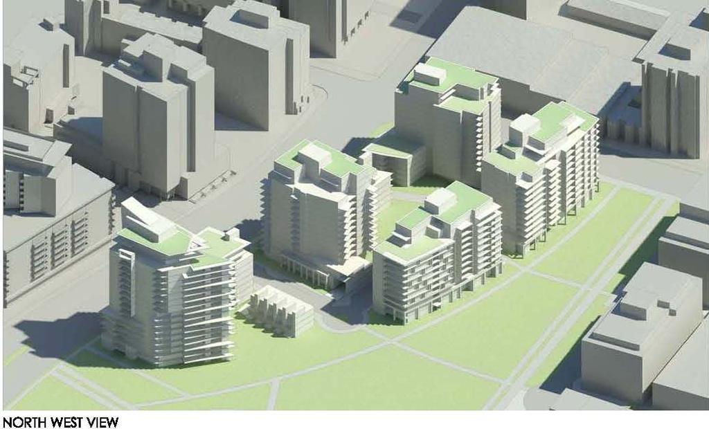
39 APPENDIX E PAGE 2 OF 10

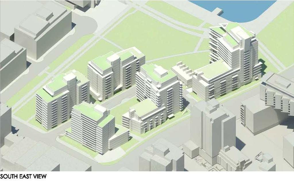
40 APPENDIX E PAGE 3 OF 10

41 APPENDIX E PAGE 4 OF 10

42 APPENDIX E PAGE 5 OF 10

43 APPENDIX E PAGE 6 OF 10

44 APPENDIX E PAGE 7 OF 10

45 APPENDIX E PAGE 8 OF 10

46 Subdivision Plan APPENDIX E PAGE 9 OF 10

47 APPENDIX E PAGE 10 OF 10 Development Phasing Plan * * * * *
48 APPENDIX F PAGE 1 OF Quebec Street, 1600 Ontario Street, and 95 East 1st Avenue (Southeast False Creek Areas 3A and 3B) 1 Application and Intent Draft Design Guidelines 1.1 Application These guidelines should be used in conjunction with the Southeast False Creek Areas 3A & 3B (xxx) bylaw and the Southeast False Creek Public Real Plan to guide development of the area. As well as assisting the development permit applicant, the guidelines will be used by City staff in evaluating proposed developments. The guidelines will assist the design of individual developments to ensure compatibility with the overall urban design concept and principles for the area within the larger context of Southeast False Creek. 1.2 Intent The intent of these guidelines is to assist the applicant in meeting the following goals and objectives: (a) Assist in the creation of a mixed-use district that supports residential and recreational park uses. (b) Integrate existing and future greenways, parks, public spaces, and walking and cycling connections. (c) Achieve overall development which demonstrates urban design and architectural excellence. (d) Provide direction in the overall design of public spaces including East Park, Railspur Mews and Artefact Plaza. 1.3 Site Description The site is located on the northeast corner of Quebec Street and East 1st Avenue in SEFC, bordered by the seawall walkway to the north and Ontario Street to the west. The site is presently a vacant paved lot used as a temporary parking facility. The site is in close proximity to all three Skytrain lines, and adjacent to Science World, the SEFC Community Centre and The Village on False Creek. These Areas 3A and 3B lands represent the remaining vacant lands between The Village and the active development underway on the east side of Quebec Street. Total site area for these Areas 3A and 3B lands is 25,943 m2 (279,253 sf).
49 APPENDIX F PAGE 2 OF 15 2 Urban Design Principles The plan for the neighbourhood contains several unique features that will play a major role in helping to define and individualize this emerging area. These features will also serve to reinforce an important sense of community interaction and provide a tangible connection to both the surrounding natural and urban environments. 2.1 Site Planning and Buildings a) Create a strong sense of place and identity by reflecting the industrial history through architecture, site planning, design and public realm features. b) Create an enhanced public realm interface with the existing and proposed streets and lanes through buildings that actively address and engage the street frontage. c) Provide a high degree of access to the public outdoor amenities. d) Provide a large variety of public spaces in size and character. e) Establish site grades in the context of current defined flood plain levels. f) Work within the height limits and preserving view cones. 2.2 Open Space (a) Provide the following public spaces: i) Provide approximately 0.18 hectares of park from Area 3B as required in the SEFC ODP. ii) Provide a portion of hectares of park for Areas 1A, 2A and 3A (as required in the SEFC ODP) in the form of East Park. iii) Provide a pedestrian-only mews running east-west between subareas 1 and 2. iv) Provide a pedestrian only pathway running east-west between subareas 3 and 4. v) Provide a new vehicular- and pedestrian-serving street located between subareas 2 and 5, running east-west. vi) Provide a new vehicular- and pedestrian-serving lane running north-south between subareas 1&2 and 3&4. vii) Provide a public plaza directly located due north of the west end of Railspur Mews, which will also address a pedestrian desire line by aligning with the eastwest pedestrian lane identified in 2.2(a)iv). viii) Provide a public plaza directly located south of Building 1, at the south east corner, oriented in an east-west direction to maximize afternoon sun access. Further, to provide supplementary public space oriented in a north-south direction along Quebec Street as an interim state until the future implementation of a streetcar line. b) Provide strong visual links to the public and semi-public open spaces from adjacent streets to invite the community in. c) Create a unique sense of place in the surrounding public realm elements that support opportunities for social engagement and public art. d) All open spaces should foster social interaction and become neighbourhood meeting places.
50 APPENDIX F PAGE 3 OF Movement and Circulation a) Integrate the development with the city by extending the street grid into the site to create physical and visual connections with the adjacent areas. Create rational normalized intersections wherever possible. b) Provide safe, comfortable and convenient walking and cycling connections accessible to all users, between the seawall, the future Central Valley Greenway,the future bike lane on Quebec Street, and the existing bike lane along Ontario Street. c) Design streets to prioritize walking and cycling over motor vehicles. d) Minimize slopes on the site to provide comfort for people walking, cycling or using mobility aids. e) Design all roads, pathways and public spaces to be fully accessible. f) Design the west side of Quebec Street to allow safe access and egress to the site for all road users and prioritize pedestrians and cyclists while respecting the street s role as a secondary traffic and goods movement corridor. g) Locate vehicular access and servicing points for all development sites to minimize conflicts and provide a safe environment for all road users. 2.4 Sustainability a) Reinforce the proposed concepts which meet the requirements of the Rezoning Policy for Sustainable Large Developments. b) Enforce the requirement for sustainable green energy through the integration of all new buildings with the SEFC Neighbourhood energy Utility. c) Reinforce the requirement for LEED Gold Certification for each building. 3.0 Site Considerations 3.1 Site Planning and Buildings The location of streets, open spaces, development parcels and buildings should generally be as described in the illustrative plan shown in Figure 1. Buildings are to be organized to define streets, lanes and mews to form a vertical and horizontal built-form edge.
 setback along Quebec Street, from the new property line after road dedication, for front patios and balconies and to provide added distance from the Quebec street traffic noise.")
51 APPENDIX F PAGE 4 OF 15 Figure Setbacks a) Provide a 3.05-m (10 ft.) setback along Quebec Street, from the new property line after road dedication, for front patios and balconies and to provide added distance from the Quebec street traffic noise. b) Provide a minimum 3.05-m (10 ft.) setback along 1st Avenue, from the new property line after road dedication, for sidewalk widening. c) Provide a minimum 2.5-m (8 ft.) setback from the curved western property line, for front patios and landscaping located on private property to enhance the public realm. d) Provide a minimum 2.5-m (8 ft.) setback from the west and north property lines of Parcel 5, for soft landscaping treatments, projecting balconies and outdoor patios. e) Provide a minimum 2.0-m (6.5 ft.) setback from the south property line of Parcel 5, off Switchmen street, for landscaping and front entrance patios. f) Provide a minimum 1.0-m (3.3 ft.) setback from the property lines off the new laneway running north-south, for buildings 1, 3 and 4.
Acting General Manager of Planning and Development Services
 POLICY REPORT DEVELOPMENT AND BUILDING Report Date: March 9, 2016 Contact: Kent Munro Contact No.: 604.873. 7135 RTS No.: 11387 VanRIMS No.: 08-2000-20 Meeting Date: April 19, 2016 TO: FROM: SUBJECT: Vancouver
Welcome to the Oakridge Centre Open House
 Welcome to the Oakridge Centre Open House Why is the City hosting this event? This open house is to inform you of a rezoning application submitted to the City of Vancouver to amend the existing CD-1 (Comprehensive
General Manager of Planning and Development Services
 POLICY REPORT DEVELOPMENT AND BUILDING Report Date: September 13, 2013 Contact: Kent Munro Contact No.: 604.873.7135 RTS No.: 10255 VanRIMS No.: 08-2000-20 Meeting Date: September 24, 2013 TO: FROM: SUBJECT:
Standing Committee on Policy and Strategic Priorities. Acting General Manager of Planning & Development Services
 POLICY REPORT DEVELOPMENT AND BUILDING Report Date: June 14, 2016 Contact: Susan Haid Contact No.: 604.871.6431 RTS No.: 11457 VanRIMS No.: 08-2000-20 Meeting Date: June 29, 2016 TO: FROM: SUBJECT: Standing
Rezoning Frequently Asked Questions
 elcome The City of Vancouver has received an application to rezone 6929-6969 Cambie Street and 515 est 54th Avenue from RS-1 (Single Family) District to CD-1 (Comprehensive Development) District. The proposal
Report Date: January 28, 2014 Contact: Matt Shillito Contact No.: RTS No.: VanRIMS No.: Meeting Date: February 4, 2014
 ADMINISTRATIVE REPORT Report Date: January 28, 2014 Contact: Matt Shillito Contact No.: 604.871.6431 RTS No.: 10327 VanRIMS No.: 08-2000-20 Meeting Date: February 4, 2014 TO: FROM: SUBJECT: Vancouver City
PUBLIC HEARING December 13, 2016 SUMMARY AND RECOMMENDATION
 PUBLIC HEARING December 13, 2016 SUMMARY AND RECOMMENDATION 7. REZONING: 151-157 West 41st Avenue Summary: To rezone 151-157 West 41st Avenue from RS-1 (One-Family Dwelling) District to CD-1 (Comprehensive
East Panorama Ridge Concept Plan Amendment
 Page 1 of 7 L003 : East Panorama Ridge Concept Plan Amendment Corporate NO: L003 Report COUNCIL DATE: March 4, 2002 REGULAR COUNCIL LAND USE TO: Mayor & Council DATE: February 27, 2002 FROM: General Manager,
Enhanced Planning Process
 Welcome The City of Vancouver has received an application to rezone 725-747 Southeast Marine Drive from CD-1 (Comprehensive Development) District to a revised CD-1 District By-law. The proposal is for
646 Kingston Road - Official Plan Amendment and Zoning Amendment Applications - Preliminary Report
 STAFF REPORT ACTION REQUIRED 646 Kingston Road - Official Plan Amendment and Zoning Amendment Applications - Preliminary Report Date: December 8, 2014 To: From: Wards: Reference Number: Toronto and East
30 and 44 Zorra Street - Zoning By-law Amendment Application - Preliminary Report
 STAFF REPORT ACTION REQUIRED 30 and 44 Zorra Street - Zoning By-law Amendment Application - Preliminary Report Date: March 14, 2016 To: From: Wards: Reference Number: Etobicoke York Community Council Director,
Official Plan Review: Draft Built Form Policies
 PG.30.1 REPORT FOR ACTION Official Plan Review: Draft Built Form Policies Date: May 15, 2018 To: Planning and Growth Management Committee From: Chief Planner and Executive Director, City Planning Division
Welcome. Walk Around. Talk to Us. Write Down Your Comments
 Welcome This is an information meeting introducing the applications for proposed redevelopment of the Yorkdale Shopping Centre site at 3401 Dufferin Street and 1 Yorkdale Road over the next 20+ years,
(DC1) Direct Development Control Provision DC1 Area 4
 Direct Development Control Provision DC1 Area 4") . General Purpose (DC) Direct Development Control Provision DC Area 4 The purpose of this Provision is to provide for an area of commercial office employment and residential development in support of the
. General Purpose (DC) Direct Development Control Provision DC Area 4 The purpose of this Provision is to provide for an area of commercial office employment and residential development in support of the
General Manager of Planning and Development Services
 POLICY REPORT DEVELOPMENT AND BUILDING Report Date: June 13, 2014 Contact: Kevin McNaney Contact No.: 604.873.7135 RTS No.: 10616 VanRIMS No.: 08-2000-20 Meeting Date: July 22, 2014 TO: FROM: SUBJECT:
13 THORNHILL YONGE STREET STUDY IMPLEMENTATION CITY OF VAUGHAN OPA 669 AND TOWN OF MARKHAM OPA 154
 13 THORNHILL YONGE STREET STUDY IMPLEMENTATION CITY OF VAUGHAN OPA 669 AND TOWN OF MARKHAM OPA 154 The Planning and Economic Development Committee recommends the adoption of the recommendations contained
1071 King Street West Zoning Amendment Application - Preliminary Report
 STAFF REPORT ACTION REQUIRED 1071 King Street West Zoning Amendment Application - Preliminary Report Date: August 9, 2012 To: From: Wards: Reference Number: Toronto and East York Community Council Director,
The Corporation of the TOWN OF MILTON
 Report to: From: Chair & Members of the Administration & Planning Standing Committee W.F. Mann, Director of Planning and Development Date: April 16, 2012 PD 022-12 (Z19/11) Subject: Technical Report Proposed
DRAFT Northeast Quadrant of Kipling Avenue and Highway 7 DRAFT AUGUST 29, Goals Land Use. The goals of this Plan are to:
 AUGUST 29, 2017 12.15 Northeast Quadrant of Kipling Avenue and Highway 7 12.15.1 Goals 12.15.2 Land Use The goals of this Plan are to: 12.15.2.1 General Provisions: a) Ensure the development of a compact
523, 525 and 525A Adelaide Street West - Zoning Amendment Application - Preliminary Report
 STAFF REPORT ACTION REQUIRED 523, 525 and 525A Adelaide Street West - Zoning Amendment Application - Preliminary Report Date: May 12, 2012 To: From: Wards: Reference Number: Toronto and East York Community
Mark-up of the effect of the proposed Bronte Village Growth Area OPA No.18 on the text of section 24, Bronte Village, of the Livable Oakville Plan
 Mark-up of the effect of the proposed Bronte Village Growth Area OPA No.18 on the text of section 24, Bronte Village, of the Livable Oakville Plan Notes: This document is provided for information purposes
URBAN DESIGN BRIEF. 2136&2148 Trafalgar Road. Town of Oakville
 URBAN DESIGN BRIEF 2136&2148 Trafalgar Road Town of Oakville Prepared By: METROPOLITAN CONSULTING INC For 2500674 Ontario Inc November 2016 TABLE OF CONTENTS Page No. 1.0 Introduction/Description of Subject
EXHIBIT A. Tax Increment Reinvestment Zone No. 1 (Town Center) First Amended Project Plan 1
 First Amended Project Plan 1") EXHIBIT A Tax Increment Reinvestment Zone No. 1 (Town Center) First Amended Project Plan 1 1 As amended by Resolution No. 2008-02-001(TR1R) of the Tax Increment Reinvestment Zone No.1, and approved to
EXHIBIT A Tax Increment Reinvestment Zone No. 1 (Town Center) First Amended Project Plan 1 1 As amended by Resolution No. 2008-02-001(TR1R) of the Tax Increment Reinvestment Zone No.1, and approved to
QUEEN-RIVER SECONDARY PLAN
 34 QUEEN-RIVER SECONDARY PLAN 34. QUEEN RIVER SECONDARY PLAN 1. INTRODUCTION The Queen-River area is approximately 6.4 hectares and is located at the eastern edge of the Downtown as shown on Map 34-1.
General Manager of Planning, Urban Design and Sustainability. CD-1 Rezoning: 777 Pacific Boulevard Sub-area 10C (1 Robson Street)
") RR-2(c) POLICY REPORT DEVELOPMENT AND BUILDING Report Date: June 5, 2018 Contact: Kevin McNaney Contact No.: 604.871.6851 RTS No.: 12384 VanRIMS No.: 08-2000-20 Meeting Date: June 19, 2018 TO: FROM: SUBJECT:
RR-2(c) POLICY REPORT DEVELOPMENT AND BUILDING Report Date: June 5, 2018 Contact: Kevin McNaney Contact No.: 604.871.6851 RTS No.: 12384 VanRIMS No.: 08-2000-20 Meeting Date: June 19, 2018 TO: FROM: SUBJECT:
6 Growth Management Challenges and Opportunities
 6 Growth Management Challenges and Opportunities The Town has established a goal of attaining a 50% participation rate with respect to employment opportunities versus residential population. The Town s
Land Use Amendment in Southwood (Ward 11) at and Elbow Drive SW, LOC
 at and Elbow Drive SW, LOC") 2018 November 15 Page 1 of 10 EXECUTIVE SUMMARY This land use amendment application was submitted by Rick Balbi Architect on 2017 August 31 on behalf of Sable Developments Ltd, and with authorization from
2018 November 15 Page 1 of 10 EXECUTIVE SUMMARY This land use amendment application was submitted by Rick Balbi Architect on 2017 August 31 on behalf of Sable Developments Ltd, and with authorization from
LAND USE AMENDMENT DOWNTOWN COMMERCIAL CORE (WARD 7) MACLEOD TRAIL SE AND 5 AVENUE SE BYLAW 254D2017
 MACLEOD TRAIL SE AND 5 AVENUE SE BYLAW 254D2017") Page 1 of 10 EXECUTIVE SUMMARY This Land Use Amendment application seeks to redesignate a full downtown block (currently the YWCA site) from a Direct Control based on the CM-2 District (Land Use Bylaw
Page 1 of 10 EXECUTIVE SUMMARY This Land Use Amendment application seeks to redesignate a full downtown block (currently the YWCA site) from a Direct Control based on the CM-2 District (Land Use Bylaw
1-17 Anndale Drive, Bales Avenue and Glendora Avenue Zoning Amendment Application Preliminary Report
 STAFF REPORT ACTION REQUIRED 1-17 Anndale Drive, 31-35 Bales Avenue and 22-70 Glendora Avenue Zoning Amendment Application Preliminary Report Date: August 20, 2007 To: From: Wards: Reference Number: North
DAVENPORT VILLAGE SECONDARY PLAN
 27 DAVENPORT VILLAGE SECONDARY PLAN 27. DAVENPORT VILLAGE SECONDARY PLAN 1. VISION FOR THE DAVENPORT VILLAGE SECONDARY PLAN Davenport Village, municipally known as 830, 940, 980 and 1100 Lansdowne Avenue,
Bloor St. W. Rezoning - Preliminary Report
 STAFF REPORT ACTION REQUIRED 1638-1644 Bloor St. W. Rezoning - Preliminary Report Date: April 1, 2008 To: From: Wards: Reference Number: Toronto and East York Community Council Acting Director, Community
280 Manse Road - Official Plan Amendment, Zoning Amendment, Draft Plan of Subdivision Applications - Preliminary Report
 STAFF REPORT ACTION REQUIRED 280 Manse Road - Official Plan Amendment, Zoning Amendment, Draft Plan of Subdivision Applications - Preliminary Report Date: March 11, 2014 To: From: Wards: Reference Number:
1296 Kennedy Road - Zoning Amendment Application - Preliminary Report
 STAFF REPORT ACTION REQUIRED 1296 Kennedy Road - Zoning Amendment Application - Preliminary Report Date: January 15, 2016 To: From: Wards: Reference Number: Scarborough Community Council Acting Director,
KEY MAP DEVELOPMENT PERMIT AREA MAP. Sunnymede North Sub-Area Plan
 Richmond Official Community Plan BROADMOOR AREA SUNNYMEDE NORTH SUB-AREA PLAN Bylaw 7100 Schedule 2.6C SUNNYMEDE NORTH SUB-AREA PLAN SUNNYMEDE NORTH SUB-AREA PLAN SUNNYMEDE NORTH SUB-AREA PLAN KEY MAP
Figure 3-1: Public Realm Plan
 3 Public Realm Figure 3-1: Public Realm Plan 3.1 Public Realm Concept The public realm concept for the Little Mountain site integrates a clear and accessible movement network with public spaces for social
CITY OF VANCOUVER PLANNING AND DEVELOPMENT SERVICES DEVELOPMENT PERMIT STAFF COMMITTEE REPORT FEBRUARY 25, 2015
 CITY OF VANCOUVER PLANNING AND DEVELOPMENT SERVICES DEVELOPMENT PERMIT STAFF COMMITTEE REPORT FEBRUARY 25, 2015 FOR THE DEVELOPMENT PERMIT BOARD MARCH 23, 2015 1661 QUEBEC STREET (COMPLETE APPLICATION)
LAND USE AMENDMENT CORNERSTONE (WARD 3) 60 STREET NE AND COUNTRY HILLS BOULEVARD NE MAP 26NE BYLAW 22D2017
 60 STREET NE AND COUNTRY HILLS BOULEVARD NE MAP 26NE BYLAW 22D2017") Page 1 of 14 EXECUTIVE SUMMARY This Land Use Amendment application covers an area of 43.76 hectares ± (108.14 acres ±) located in northeast Calgary, bound by Country Hills Boulevard NE to the south and
Page 1 of 14 EXECUTIVE SUMMARY This Land Use Amendment application covers an area of 43.76 hectares ± (108.14 acres ±) located in northeast Calgary, bound by Country Hills Boulevard NE to the south and
PUBLIC HEARING May 18, 2010 SUMMARY AND RECOMMENDATION
 PUBLIC HEARING May 18, 2010 SUMMARY AND RECOMMENDATION 7. REZONING: 5912-5970 Oak Street Summary: To rezone from RS-1 (single-family) to Comprehensive Development (CD-1) District to permit a 27-unit townhouse
Report Date: April 17, 2018 Contact: Kent Munro Contact No.: RTS No.: VanRIMS No.: Meeting Date: May 1, 2018
 POLICY REPORT Report Date: April 17, 2018 Contact: Kent Munro Contact No.: 604.873.7135 RTS No.: 12517 VanRIMS No.: 08-2000-20 Meeting Date: May 1, 2018 TO: FROM: SUBJECT: Vancouver City Council General
[PLANNING RATIONALE] For Site Plan Control and Lifting of Holding Zone By-Law 101 Champagne Avenue. May 23, 2014
![[PLANNING RATIONALE] For Site Plan Control and Lifting of Holding Zone By-Law 101 Champagne Avenue. May 23, 2014](/thumbs/75/71599615.jpg "[PLANNING RATIONALE] For Site Plan Control and Lifting of Holding Zone By-Law 101 Champagne Avenue. May 23, 2014") [PLANNING RATIONALE] For Site Plan Control and Lifting of Holding Zone By-Law 101 Champagne Avenue May 23, 2014 Contents 1.0 Introduction... 2 2.0 Site Context... 2 2.1 Adjacent Uses... 2 Figure 1: Site
[PLANNING RATIONALE] For Site Plan Control and Lifting of Holding Zone By-Law 101 Champagne Avenue May 23, 2014 Contents 1.0 Introduction... 2 2.0 Site Context... 2 2.1 Adjacent Uses... 2 Figure 1: Site
City of Surrey PLANNING & DEVELOPMENT REPORT File:
 City of Surrey PLANNING & DEVELOPMENT REPORT File: 7916-0362-00 Planning Report Date: July 10, 2017 PROPOSAL: Development Permit Development Variance Permit to allow a truck/trailer staging area and to
599 Kennedy Road - Official Plan Amendment and Zoning Amendment Application - Preliminary Report
 STAFF REPORT ACTION REQUIRED 599 Kennedy Road - Official Plan Amendment and Zoning Amendment Application - Preliminary Report Date: March 7, 2017 To: From: Wards: Reference Number: Scarborough Community
Wellington Street West - Zoning Amendment Application - Preliminary Report
 STAFF REPORT ACTION REQUIRED 485-489 Wellington Street West - Zoning Amendment Application - Preliminary Report Date: September 26, 2016 To: From: Wards: Reference Number: Toronto and East York Community
178 Carruthers Properties Inc.
 178 Carruthers Properties Inc. Planning Rationale for 178 Carruthers Avenue Site Plan Control Application June 2014 Table of Contents 1.0 Introduction 2.0 Overview of Subject Property 3.0 Current Zoning
Gold Line Bus Rapid Transit Transit Oriented Development (BRTOD) Helmo Station Area Plan
 Helmo Station Area Plan") Appendix F Gold Line Bus Rapid Transit Transit Oriented Development (BRTOD) Helmo Station Area Plan Introduction and Purpose of the Plan The Gold Line Bus Rapid Transit facility is an eleven-mile dedicated
Appendix F Gold Line Bus Rapid Transit Transit Oriented Development (BRTOD) Helmo Station Area Plan Introduction and Purpose of the Plan The Gold Line Bus Rapid Transit facility is an eleven-mile dedicated
1.0 Purpose of a Secondary Plan for the Masonville Transit Village
 Report to Planning and Environment Committee To: Chair and Members Planning & Environment Committee From: John M. Fleming Managing Director, Planning and City Planner Subject: Masonville Transit Village
DRAFT PLAN OF SUBDIVISION PLANNING RATIONALE 5100 KANATA AVENUE CITY OF OTTAWA. Hawthorn Retirement Group MALONE GIVEN PARSONS LTD.
 DRAFT PLAN OF SUBDIVISION PLANNING RATIONALE 5100 KANATA AVENUE CITY OF OTTAWA Prepared By: MALONE GIVEN PARSONS LTD. Prepared For: Hawthorn Retirement Group July 2015 Draft Plan of Subdivision 5100 Kanata
ONTARIO MUNICIPAL BOARD
 PL 120483 ONTARIO MUNICIPAL BOARD Applicant/Appellant: 2124123 Ontario Limited Subject: OPA, Rezoning and Draft Plan of Subdivision Municipal Address: 3940 Highway 7 East Municipality: City of Markham
Cambie Corridor Planning Program Phase Two Draft Plan. Standing Committee on City Services and Budgets May 5, 2011
 Cambie Corridor Planning Program Phase Two Draft Plan Standing Committee on City Services and Budgets May 5, 2011 Cambie Corridor Program Terms of Reference approved July 2009 Land Use Transportation Energy
This Review Is Divided Into Two Phases:
 Semiahmoo Town Centre Review The purpose of this review: To review the Semiahmoo Town Centre Concept Plan, originally approved in 1993, to ensure that this centre will continue to serve the needs of South
implementation r expression in landscape
 6 ubc okanagan implementation campus plan r expression in landscape 68 6 implementation campus plan sections The Campus Plan supports the academic mission, values and commitments of the University by providing
Approved: CITY OF ARDEN HILLS, MINNESOTA PLANNING COMMISSION WEDNESDAY, AUGUST 5, :30 P.M. - ARDEN HILLS CITY HALL
 Approved: CITY OF ARDEN HILLS, MINNESOTA PLANNING COMMISSION WEDNESDAY, AUGUST 5, 2015 6:30 P.M. - ARDEN HILLS CITY HALL PLANNING CASES A. Planning Case 15-016; Final Planned Unit Development Arden Plaza;
From: Director, Community Planning, Scarborough District. Ward 40 Scarborough-Agincourt
 STAFF REPORT ACTION REQUIRED 2967 Sheppard Ave E - Zoning Amendment Application - Preliminary Report Date: July 18, 2014 To: Scarborough Community Council From: Director, Community Planning, Scarborough
BROADWAY-ARBUTUS POLICIES. Adopted by City Council on July 7, NOTE: To be considered in combination with applicable guidelines
 50 City of Vancouver Land Use and Development Policies and Guidelines Community Services, 453 W. 12th Ave Vancouver, BC V5Y 1V4 F 873.7344 fax 873.7060 planning@city.vancouver.bc.ca BROADWAY-ARBUTUS POLICIES
Stanley Greene District Downsview (80 Carl Hall Road) Zoning By-law Amendment and Draft Plan of Subdivision Applications Request for Direction Report
 Zoning By-law Amendment and Draft Plan of Subdivision Applications Request for Direction Report") STAFF REPORT ACTION REQUIRED Stanley Greene District Downsview (80 Carl Hall Road) Zoning By-law Amendment and Draft Plan of Subdivision Applications Request for Direction Report Date: December 16, 2011
STAFF REPORT ACTION REQUIRED Stanley Greene District Downsview (80 Carl Hall Road) Zoning By-law Amendment and Draft Plan of Subdivision Applications Request for Direction Report Date: December 16, 2011
4780 Eglinton Avenue West - Zoning By-law Amendment and Draft Plan of Subdivision Applications - Preliminary Report
 STAFF REPORT ACTION REQUIRED 4780 Eglinton Avenue West - Zoning By-law Amendment and Draft Plan of Subdivision Applications - Preliminary Report Date: May 29, 2014 To: From: Wards: Reference Number: Etobicoke
burlington mobility hubs study Downtown Burlington Mobility Hub
 burlington mobility hubs study Downtown Burlington Mobility Hub Draft Precinct Plan Workbook PIC #3, September 7, 2017 downtown mobility hub objectives City staff and their consultants are proposing an
APPLICATION BRIEFING Prepared For: Submitted by: Date: Subject:
 Planning & Development APPLICATION BRIEFING Prepared For: Submitted by: Date: Subject: Planning Advisory Committee Jason Fox, Director of Planning & Development Development Agreement application by Godfrey
John M. Fleming Managing Director, Planning and City Planner. Old East Village Dundas Street Corridor Secondary Plan Draft Terms of Reference
 Report to Planning and Environment Committee To: From: Subject: Chair and Members Planning & Environment Committee John M. Fleming Managing Director, Planning and City Planner Old East Village Dundas Street
CITY OF VAUGHAN EXTRACT FROM COUNCIL MEETING MINUTES OF MAY 27, 2014
 CITY OF VAUGHAN EXTRACT FROM COUNCIL MEETING MINUTES OF MAY 27, 2014 Item 6, Report No. 21, of the Committee of the Whole, which was adopted without amendment by the Council of the City of Vaughan on May
Smart Growth Development Checklist
 2004 Smart Growth Development Checklist Smart Growth Development Checklist Corporation of the City of New Westminster Guide and manage growth in a manner which is consistent with the principles of sustainable
The West Vaughan Employment Area Secondary Plan Policies
 Part 2: The West Vaughan Employment Area Secondary Plan Policies 2.1 General Policies It is the policy of Council: 2.1.1. That the West Vaughan Employment Area (the WVEA), identified on Schedule 1, will
BYLAW C A Bylaw of Rocky View County to amend Land Use Bylaw C
 BYLAW C-7720-2017 A Bylaw of Rocky View County to amend Land Use Bylaw C-4841-97. The Council of Rocky View County enacts as follows: PART 1 TITLE This Bylaw shall be known as Bylaw C-7720-2017. PART 2
CITY OF VANCOUVER POLICY REPORT DEVELOPMENT AND BUILDING
 CITY OF VANCOUVER P7 POLICY REPORT DEVELOPMENT AND BUILDING Report Date: July 8, 2008 Author: Kirsten Robinson / Matt Shillito Phone No.: 604.871.6889 / 604.871.6431 RTS No.: 07255 VanRIMS No.: 08-2000-20
Derry Green Corporate Business Park
 Town of Milton Derry Green Corporate Business Park Urban Design Guidelines BMI/Pace - June 2010 Draft 3 Prepared by: Brook McIlroy Planning + Urban Design / Pace Architects Suite 300-51 Camden Street Toronto,
SUBJECT: Proposed Downtown Mobility Hub Precinct Plan and Proposed Official Plan Policies
 Page 1 of Report PB-81-17 SUBJECT: Proposed Downtown Mobility Hub Precinct Plan and Proposed Official Plan Policies TO: FROM: Committee of the Whole Planning and Building Department Report Number: PB-81-17
Clairtrell Area Context Plan
 Clairtrell Area Context Plan March 2005 Urban Development Services City Planning Contents 1. Introduction... 4 2. Development Structure... 6 2.1 Streets... 7 2.1.1 Sheppard Avenue and Bayview Avenue...
CD-1 Rezoning: 4500 Oak Street (Children s and Women s Health Centre of British Columbia)
") P2 POLICY REPORT DEVELOPMENT AND BUILDING Report Date: November 2, 2012 Contact: Kent Munro Contact No.: 604.873.7135 RTS No.: 9666 VanRIMS No.: 08-2000-20 Meeting Date: November 13, 2012 TO: FROM: SUBJECT:
P2 POLICY REPORT DEVELOPMENT AND BUILDING Report Date: November 2, 2012 Contact: Kent Munro Contact No.: 604.873.7135 RTS No.: 9666 VanRIMS No.: 08-2000-20 Meeting Date: November 13, 2012 TO: FROM: SUBJECT:
ARLINGTON COUNTY, VIRGINIA
 ARLINGTON COUNTY, VIRGINIA County Board Agenda Item Meeting of April 23, 2019 DATE: April 12, 2019 SUBJECT: SP #413 SITE PLAN AMENDMENT to permit a fixed bar in a private outdoor café space with associated
MOUNT PLEASANT COMMUNITY PLAN
 MOUNT PLEASANT COMMUNITY PLAN What is a Community Plan? A community plan describes what the community should be like in the future: it identifies what is valuable and should be retained, as well as Key
Bayview Avenue Official Plan Amendment, Zoning Amendment and Site Plan Control Applications Request for Direction Report
 STAFF REPORT ACTION REQUIRED 2425 2427 Bayview Avenue Official Plan Amendment, Zoning Amendment and Site Plan Control Applications Request for Direction Report Date: May 28, 2015 To: From: Wards: Reference
Uptown Rideau Street Secondary Plan [Amendment #166, January 12, 2016]
![Uptown Rideau Street Secondary Plan [Amendment #166, January 12, 2016]](/thumbs/76/73760497.jpg "Uptown Rideau Street Secondary Plan [Amendment #166, January 12, 2016]") [Amendment #166, January 12, 2016] The policies of this Secondary Plan are in effect, save and except for the property at 560 Rideau Street, for which there remains a site specific appeal to this Secondary
[Amendment #166, January 12, 2016] The policies of this Secondary Plan are in effect, save and except for the property at 560 Rideau Street, for which there remains a site specific appeal to this Secondary
Regency Developments. Urban Design Brief. Holyrood DC2 Rezoning
 Regency Developments Urban Design Brief Holyrood DC2 Rezoning Stantec Consulting Ltd. 7-31-2017 1. Overview Regency Developments intends to rezone the lands located at 8510 and 8511 93 Avenue, within the
Urban Design Brief December 23, 2015 Southside Construction Group Official Plan & Zoning By-Law Amendment
 Urban Design Brief Proposed Official Plan & Zoning By-Law Amendment 3244, 3263 and 3274 Wonderland Road South Southside Group December 23, 2015 TABLE OF CONTENTS Page No. INTRODUCTION... 1 SECTION 1 LAND
Edward R. Sajecki Commissioner of Planning and Building
 Corporate Report Clerk s Files Originator s Files CD.03.POR DATE: TO: FROM: SUBJECT: Chair and Members of Planning and Development Committee Meeting Date: February 27, 2012 Edward R. Sajecki Commissioner
Urban Design Brief Woodland Cemetery Funeral Home 493 Springbank Drive
 Urban Design Brief Woodland Cemetery Funeral Home The Incorporated Synod of the Diocese of Huron April 15, 2016 Urban Design Brief April 15, 2016 TABLE OF CONTENTS Page No. INTRODUCTION... 1 SECTION 1
Attachment 1 TOWN OF NEW TECUMSETH. Manual for the Preparation of an Urban Design Report
 Attachment 1 TOWN OF NEW TECUMSETH Manual for the Preparation of an Urban Design Report July 2010 TABLE OF CONTENTS Background, Policy Framework and the Preparation of Urban Design Reports 1. Introduction
TOURIST AREA DESIGN GUIDELINES
 TOURIST AREA DESIGN GUIDELINES INTRODUCTION The purpose of the Tourist Area Design Guidelines is to provide a comprehensive reference manual to the urban design principles that will be used to evaluate
SECTION E. Realizing the Plan
 SECTION E Realizing the Plan 60 DESIGN REGINA - OFFICIAL COMMUNITY PLAN SECTION E Realizing the Plan Design Regina has been an ambitious plan-making exercise, with a high level of community, stakeholder,
North York Community Council. Director, Community Planning, North York District. Ward No. 26, Don Valley West
 STAFF REPORT ACTION REQUIRED 85 Laird Drive Zoning Application - Final Report Date: December 18, 2007 To: From: Wards: Reference Number: North York Community Council Director, Community Planning, North
FORMER CANADIAN FORCES BASE (CFB) ROCKCLIFFE SECONDARY PLAN. Official Plan Amendment XX to the Official Plan for the City of Ottawa
 ROCKCLIFFE SECONDARY PLAN. Official Plan Amendment XX to the Official Plan for the City of Ottawa") FORMER CANADIAN FORCES BASE (CFB) ROCKCLIFFE SECONDARY PLAN Official Plan Amendment XX to the Official Plan for the City of Ottawa 1 INDEX THE STATEMENT OF COMPONENTS PART A THE PREAMBLE PAGE Purpose...
FORMER CANADIAN FORCES BASE (CFB) ROCKCLIFFE SECONDARY PLAN Official Plan Amendment XX to the Official Plan for the City of Ottawa 1 INDEX THE STATEMENT OF COMPONENTS PART A THE PREAMBLE PAGE Purpose...
CITY OF VANCOUVER PLANNING & DEVELOPMENT SERVICES. DEVELOPMENT PERMIT STAFF COMMITTEE REPORT September 23, 2015
 CITY OF VANCOUVER PLANNING & DEVELOPMENT SERVICES DEVELOPMENT PERMIT STAFF COMMITTEE REPORT September 23, 2015 FOR THE DEVELOPMENT PERMIT BOARD October 5, 2015 1768 COOK STREET (COMPLETE APPLICATION) DEVELOPMENT
Queen Street West - Zoning Amendment Application - Preliminary Report
 STAFF REPORT ACTION REQUIRED 944-952 Queen Street West - Zoning Amendment Application - Preliminary Report Date: February 6, 2013 To: From: Wards: Reference Number: Toronto and East York Community Council
Planning Commission Staff Report June 5, 2008
 Owner/Applicant Taylor Village Sacramento Investments Partners, LP c/o Kim Whitney 1792 Tribute Road #270 Sacramento, CA 95815 Staff Recommendation Planning Commission Staff Report Project: File: Request:
SECTION ONE: INTRODUCTION. introduction
 introduction 1 INTRODUCTION Since it was first established in 1843 as a trading post for the Hudson s Bay Company, Victoria has evolved into a Provincial capital city that is recognized across Canada and
Official Community Plan Bylaw No. 4360, 2004, Amendment Bylaw No. 4897, 2016 (Sewell s Landing)
") District of West Vancouver Official Community Plan Bylaw No. 4360, 2004, Amendment Bylaw No. 4897, 2016 (Sewell s Landing) Effective Date: 1089612v1 District of West Vancouver Official Community Plan Bylaw
District of West Vancouver Official Community Plan Bylaw No. 4360, 2004, Amendment Bylaw No. 4897, 2016 (Sewell s Landing) Effective Date: 1089612v1 District of West Vancouver Official Community Plan Bylaw
Demolition of a Designated Heritage Property Roncesvalles Avenue
 REPORT FOR ACTION Demolition of a Designated Heritage Property - 421 Roncesvalles Avenue Date: March 8, 2018 To: Toronto Preservation Board Toronto and East York Community Council From: Acting Chief Planner
I615. Westgate Precinct
 I615. Westgate Precinct I615.1. Precinct Description The Westgate Precinct is located approximately 18km west of the Auckland city centre. There are seven Sub-precincts in the Westgate Precinct: Sub-precinct
General Manager of Planning, Urban Design and Sustainability
 RR-2(b) POLICY REPORT DEVELOPMENT AND BUILDING Report Date: June 5, 2018 Contact: Kevin McNaney Contact No.: 604.871.6851 RTS No.: 12589 VanRIMS No.: 08-2000-20 Meeting Date: June 19, 2018 TO: FROM: Vancouver
ADMINISTRATION RECOMMENDATION 2016 November 03. That Calgary Planning Commission recommends APPROVAL of the proposed Land Use Amendment.
 Page 1 of 12 EXECUTIVE SUMMARY This Land Use Amendment application covers an area of 75.76 hectares ± (187.20 acres ±) located in northeast Calgary, bound by Stoney Trail NE to the north, 128 Avenue NE
REQUEST Current Zoning: O-15(CD) (office) Proposed Zoning: TOD-M(CD) (transit oriented development mixed-use, conditional)
 (office) Proposed Zoning: TOD-M(CD) (transit oriented development mixed-use, conditional)") Rezoning Petition 2016-117 Zoning Committee Recommendation January 4, 2017 REQUEST Current Zoning: O-15(CD) (office) Proposed Zoning: TOD-M(CD) (transit oriented development mixed-use, conditional) LOCATION
Rezoning Petition 2016-117 Zoning Committee Recommendation January 4, 2017 REQUEST Current Zoning: O-15(CD) (office) Proposed Zoning: TOD-M(CD) (transit oriented development mixed-use, conditional) LOCATION
14 October 10, 2012 Public Hearing APPLICANT: MPB, INC
 14 October 10, 2012 Public Hearing APPLICANT: MPB, INC PROPERTY OWNER: MUNDEN & ASSOCIATES, LP STAFF PLANNER: Karen Prochilo REQUEST: Conditional Change of Zoning (AG-1 & AG-2 to Conditional O-2) ADDRESS
MONTGOMERY COUNTY PLANNING DEPARTMENT
 MONTGOMERY COUNTY PLANNING DEPARTMENT THE MARYLAND-NATIONAL CAPITAL PARK AND PLANNING COMMISSION MCPB Item No.: Date: 5-03-18 Pike and Rose, Phase I: Site Plan Amendment No. 82012002D Rhoda Hersson-Ringskog,
KANATA CENTRUM 255 KANATA AVENUE OFFICIAL PLAN AMENDMENT ZONING BY-LAW AMENDMENT
 KANATA CENTRUM 255 KANATA AVENUE OFFICIAL PLAN AMENDMENT ZONING BY-LAW AMENDMENT JUNE 2015 PREPARED BY: FOTENN Consultants Inc. 223 Mcleod Street Ottawa, ON K2P OZ8 (613) 730-5709 PREPARED FOR: Kanata
Director, Community Planning, Toronto and East York District
 STAFF REPORT May 30, 2006 To: From: Subject: Toronto and East York Community Council Director, Community Planning, Toronto and East York District Request for Direction Report OPA & Rezoning Application
2136 & 2148 Trafalgar Road Town of Oakville Region of Halton
 PLANNING JUSTIFICATION REPORT 2136 & 2148 Trafalgar Road Town of Oakville Region of Halton Zoning By-Law Amendment Application 2500674 Ontario Inc. November 2016 Table of Contents Page 1.0 Location/Summary
6 RURAL RESIDENTIAL. 6.1 Rural Use. Rural Use (RU) Goals and Objectives. Policy Goal
 Goals and Objectives. Policy Goal") 6 RURAL RESIDENTIAL The vast majority of East Hants 466,426 acres are considered rural in nature and are characterized by a great diversity of uses. Because of this, land use policies in rural areas of
6 RURAL RESIDENTIAL The vast majority of East Hants 466,426 acres are considered rural in nature and are characterized by a great diversity of uses. Because of this, land use policies in rural areas of
4208, 4210 and 4214 Dundas Street West Official Plan and Zoning By-law Amendment Application Final Report
 STAFF REPORT ACTION REQUIRED 4208, 4210 and 4214 Dundas Street West Official Plan and Zoning By-law Amendment Application Final Report Date: October 27, 2016 To: From: Wards: Reference Number: Etobicoke
Mill Woods Town Centre Proposed Rezoning LDA
 Mill Woods Town Centre Proposed Rezoning LDA15 0649 The City of Edmonton has received an application for rezoning and an amendment to the Mill Woods Station Area Redevelopment Plan (ARP) for the Mill Woods
North Oakville East Parks Facilities Distribution Plan. November, 2009
 North Oakville East November, 2009 POLICY CONTEXT 1) Purpose a) The purpose of this document is to be a guide for the location, configuration, design and development of the parks system for the North Oakville