TO: Port of Orcas FROM: Tina Whitman, Science Director SUBJECT: Master Plan Update DATE: September 7, 2018
|
|
|
- Dennis Roy Lane
- 5 years ago
- Views:
Transcription
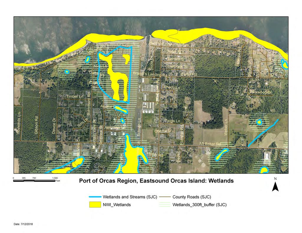
1 TO: Port of Orcas FROM: Tina Whitman, Science Director SUBJECT: Master Plan Update DATE: September 7, 2018 Friends of the San Juans appreciates the opportunity to provide input to the Port of Orcas Master Planning process and respectfully submits the following comments, primarily related to the lack of sufficient detail on relevant natural resources and associated regulations that affect future development at the Port of Orcas including wetlands, shorelines, cultural resources and land use. Wetlands Wetlands are a high value habitat type that provides multiple public benefits including water quality, fish and wildlife habitat, and flood attenuation. As a result, wetlands are protected under local, state and federal laws. With extensive, known wetlands on and adjacent to the airport, as well as current active wetland mitigation required to rectify recent Port of Orcas violations, it should come as no surprise that the management of wetland habitats will play a major role in the design and selection of alternatives under the master planning process. The current level of detail regarding the wetlands themselves, as well as the impacts to them from the various design alternatives and phasing, is not sufficient. Each wetland should be clearly identified in each of the master planning documents (site plans, alternatives evaluation tables, introduction to the development alternatives report) including clear identification for each individual wetland, the wetland category or rating, as well as the associated buffers for each wetland. Description and evaluation of each alternative/phasing must also demonstrate how it follows the required local, state and federal wetland mitigation sequence of avoidance, minimization, and lastly, compensatory mitigation, with estimated square footage or acreage of impacts in the wetlands and their buffers clearly defined for each of the alternatives/phasing. Right now the only place where wetland impacts are even mentioned is the evaluation of alternatives table where impacts to wetlands are defined as none, none anticipated, minor or potential in earlier draft documents and as none, potential, yes or no in the materials provided September 5, No discussion at all of the type and size of wetlands present, avoidance of impacts or likely impacts are provided in the development alternatives report. Without any associated documentation of the wetland values, rating and area of impact, the findings in the evaluation table cannot be credibly
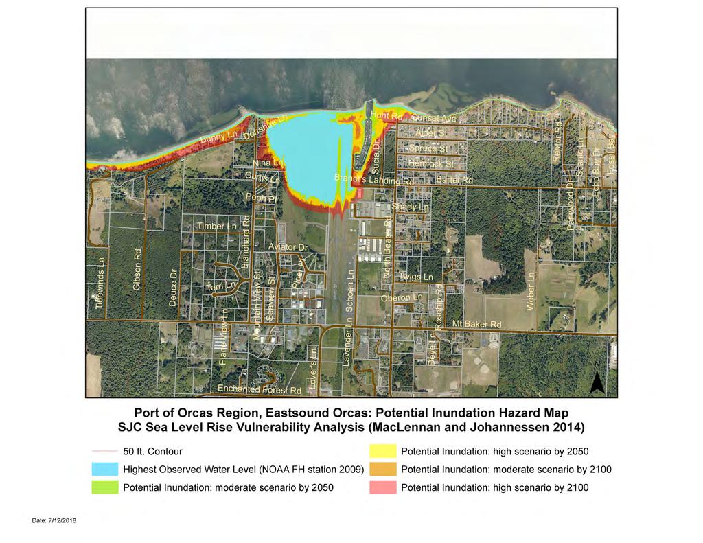
2 supported. As wetland mitigation can also have a large impact on the cost estimates of the various alternatives, sufficient detail is required on avoidance of likely impacts to wetlands of each of the alternatives to inform cost benefit analysis. In addition to more clearly identifying potential future impacts to wetlands, consistency of the proposed design alternatives with the existing required mitigation actions from the wetland violations that occurred in 2017 to multiple wetlands on Port of Orcas properties must also be addressed. For example, the rerouting of Mount Baker road illustrated in the new Figure 3. Ultimate Development or the previous Figure 9. Runway 34 RPZ Alternatives figure will directly impact the wetland, including those areas currently the subject of required mitigation action to restore function, yet no detail is provided beyond potential impacts to wetlands or yes in the table. Mitigation sites should have long-term protection and subsequent development should avoid impacting the mitigation area and associated buffer. Shorelines There is no discussion of the shoreline environment in any of the documents produced to date in the master planning process. Multiple relevant issues related to marine shorelines should be reviewed and used in both the development and evaluation of design alternatives and phasing including: the Shoreline Master Program jurisdiction (200 feet from the ordinary high water mark and all associated wetlands) and required protective regulations; the fact that the largest wetland on the Port property is an estuarine, coastal wetland; and the fact that significant Port infrastructure and proposed future developments and property acquisitions are located within mapped coastal flood hazard zones. At a minimum, the shoreline jurisdiction and floodplain boundaries should be clearly marked on all design alternatives/phasing site plans, and as with wetlands, sufficient detail on how the various alternatives will avoid, minimize and compensate for unavoidable impacts (see San Juan County Code ). The projected area of impact and effects on the function of the estuarine wetland as well as marine shoreline and floodplain habitats must also be included. As coastal erosion and flood hazards are expected to increase with rising sea levels and more frequent and larger storm events, any long range planning for the acquisition of new property or development of new permanent infrastructure must include consideration of likely potential effects. As with wetland mitigation, costs to fortify low lying coastal infrastructure as well as the associated mitigation for impacts to shoreline habitats can be substantial and may influence the selection of a preferred alternative. Cultural Resources No mention of cultural or historic resources are made in any of the Master Plan documents. Marine shorelines and associated coastal wetlands within the San Juan Islands, including north Orcas were
3 heavily utilized by multiple area Tribes and First Nations. The State Environmental Policy Act requires an evaluation of proposed development in these areas that must include adequate identification of the cultural and historic resources present and plans to avoid impacts. As with natural resource mitigation, the presence of cultural resources can add substantially to the costs of the various design alternatives and timely understanding of the likelihood of encountering protecting cultural resources is essential. Land Use The Orcas airport is located in close proximity to substantial residential and commercial development in the Eastsound subarea. Potential impacts to neighboring uses should be explicitly included in the master planning process, in both the development and evaluation of alternatives. Multiple methods exist for the Port to improve its understanding and consideration of local land use concerns, including expanding participation in the master planning committee and identifying relevant plans and policies that will impact the ultimate success of any preferred alternative. The proposed master planning committee is heavily weighted towards airplane-dependent and other commercial interests; efforts should be made to expand committee participation to better include residential interests. With significant proposed changes to public infrastructure included in the design alternatives, it is logical for the Port to involve the San Juan County Public Works Department; their expertise in planning public projects, as well as public engagement could further improve the process. In addition, while the master planning website references future environmental analysis, it would be prudent for the Port to identify the relevant plans and policies and how they may be supported by or are in conflict with the proposed alternatives at this stage of the master planning process. These include, but are not limited to: the Eastsound subarea plan, the San Juan County Critical Areas Ordinance, the state Shoreline Management Act and county Shoreline Master Program as well as federal Clean Water and state Water Pollution Control Acts, as well as National Historic Preservation and Endangered Species Acts. As just one example of why this type of review is essential at this stage of the process, the proposed September 5, 2018 Short Term Development (Figure 1) actions include acquisition of additional shoreline property; yet the fact that this property is located in a shoreline designation under the county s Shoreline Master Program that specifically prohibits airport and nonwater dependent uses is even not mentioned (San Juan County Unified Development Code ). Substantial recent information on community values and perspectives for the future of Eastsound are also available as part of the comprehensive plan update process and could inform the Master Planning process. In summary, significant additional detail to wetland, marine shoreline, cultural resources and land use issues are needed to improve the quality of the various development design options being proposed, the evaluation of the alternatives as well as the public s ability to meaningfully review and provide comment. Thank you for your consideration.
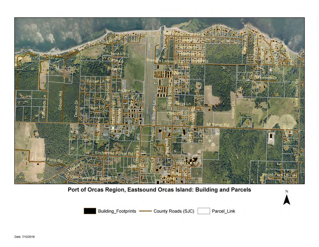
4 Attachments: a) Port of Orcas region, Eastsound wetland habitat map b) Port of Orcas region, Eastsound shoreline resources map c) Port of Orcas region, Eastsound parcel and building map d) Port of Orcas region, Eastsound floodplain map e) Port of Orcas region, Eastsound sea level rise vulnerability map e CC: Paul Kamin, Chair Eastsound Planning Review Committee Doug Gresham, Washington Department of Ecology
5
6
7
8 FEMA Floodplain
9
EXHIBIT A CITY OF FORT WALTON BEACH, FLORIDA COASTAL MANAGEMENT & CONSERVATION
 EXHIBIT A CITY OF FORT WALTON BEACH, FLORIDA INTRODUCTION The Coastal Management and the Conservation Elements required by Chapter 9J-5.012 and 5.013, F.A.C., respectively, have been combined into one
WASHINGTON COUNTY OREGON
 WASHINGTON COUNTY OREGON LONG RANGE PLANNING DIVISION North Bethany Subarea Stream Corridors: Existing Regulations In Oregon, there is a distinct difference between the land use rules that apply in rural
The Salt Marsh Advancement Zone Assessment of Connecticut
 The Salt Marsh Advancement Zone Assessment of Connecticut Front cover image: Salt marsh advancement zones in Stratford, CT from the Comprehensive Map Book of Stratford, CT. Table of Contents Introduction...
PURPOSE: The purpose is to provide commercial facilities in the Vancouver and Clark County vicinity.
 US Army Corps of Engineers Seattle District Joint Public Notice Application for a Department of the Army Permit and a Washington Department of Ecology Water Quality Certification and/or Coastal Zone Management
Staff will be providing an overview of the project need, purpose and intent for consideration as part of the Amendment cycle.
 Agenda Item D-2 City of Tacoma Planning and Development Services To: Planning Commission From: Stephen Atkinson, Planning Services Division Subject: Open Space Corridors Project Meeting Date: March 1,
ESSENTIAL PUBLIC FACILITIES
 ESSENTIAL PUBLIC FACILITIES PURPOSE This section contains guidelines and policies which outline a process and define a set of criteria to be used to identify sites for development of facilities classified
ALL SECURE SELF STORAGE SEPA APPEAL RECOMMENDATION TO THE HEARING EXAMINER
 KITSAP COUNTY DEPARTMENT OF COMMUNITY DEVELOPMENT 619 DIVISION STREET MS-36, PORT ORCHARD WASHINGTON 98366-4682 LOUISA GARBO, DIRECTOR (360) 337-5777 FAX (360) 337-4415 HOME PAGE - www.kitsapgov.com ALL
CONSERVATION ELEMENT GOALS, OBJECTIVES, AND POLICIES
 CONSERVATION ELEMENT GOALS, OBJECTIVES, AND POLICIES Goal 4 To conserve, manage, appropriately use and protect the natural resources of the City ensuring continued resource availability and environmental
Port of San Diego Sea Level Rise Ad Hoc Committee Meeting 1 of 3.. September 18, 2018
 Port of San Diego Sea Level Rise Ad Hoc Committee Meeting 1 of 3. September 18, 2018 Agenda Welcome Introductions Rules of the Ad-Hoc Presentation Background Vulnerability Assessment Results Non-Agenda
Commercial Launch Site Addendum to Wetland Mitigation Plan. Revision 2. April 25, SpaceX Proprietary
 Commercial Launch Site Addendum to Wetland Mitigation Plan Revision 2 April 25, 2017 SpaceX Proprietary Contents 1.0 Project Information... 1 1.1 Background... 1 2.0 Compensatory Mitigation... 2 2.1 Goals
Table of Contents TABLE OF CONTENTS SECTION TITLE PAGE
 TABLE OF CONTENTS SECTION TITLE PAGE 1 INTRODUCTION AND OVERVIEW 1-1 1.1 Purpose and Need 1-1 1.2 Goals and Objectives 1-3 1.3 Overview of the Planning Process 1-5 1.4 Federal and State Requirements and
THE CORPORATION OF THE CITY OF WINDSOR Office of the City Solicitor Planning Department
 THE CORPORATION OF THE CITY OF WINDSOR Office of the City Solicitor Planning Department REPORT TO THE CITY OF WINDSOR PLANNING ADVISORY COMMITTEE DATE OF REPORT: August 19, 2010 SUBJECT: Official Plan
CAO Update Status Work continues on products: Draft ordinance BAS report CAO process summary (2002 to present) Comprehensive e Plan policy review Some
 Comprehensive e Plan policy review Some") Critical Areas Ordinance Update Wetlands Andrew Deffobis Jeremy Davis Cynthia Wilson Thurston County Planning April 6, 2011 CAO Update Status Work continues on products: Draft ordinance BAS report CAO
Critical Areas Ordinance Update Wetlands Andrew Deffobis Jeremy Davis Cynthia Wilson Thurston County Planning April 6, 2011 CAO Update Status Work continues on products: Draft ordinance BAS report CAO
Options for addressing City of Edmonds Alternatives to Ecology s Required Changes addressing Edmonds Marsh Buffers and Setbacks.
 Options for addressing City of Edmonds Alternatives to Ecology s Required Changes addressing Edmonds Marsh Buffers and Setbacks. This document presents Ecology s response to the City of Edmonds alternatives
JOINT PUBLIC NOTICE. 26 June United States Army Corps of Engineers State of Louisiana
 JOINT PUBLIC NOTICE 26 June 2017 United States Army Corps of Engineers State of Louisiana New Orleans District Department of Environmental Quality Regulatory Branch Office of Environmental Services 7400
Chapter 3 Site Planning and Low Impact Development
 CHAPTER 3 Site Planning and Low Impact Development Chapter 3 Site Planning and Low Impact Development 3.0 Introduction The City of Charleston requires that major residential, large commercial (>1 acre),
Folly Beach Planning Commission
 Folly Beach Planning Commission September 10, 2018 7:00 PM REGULAR MEETING ---------------------------------------------------------------------------------------------------- Commission Members: Greg
Sierra Club Comments on ACOE Public Notice NAE Re: Proposed Town Neck Beach Project at Sandwich, Massachusetts
 August 27, 2015 US Army Corps of Engineers New England District 696 Virginia Road Concord, MA 01742-2751 Attn: Phillip W. Nimeskern Dear Mr. Nimeskern, Sierra Club Comments on ACOE Public Notice NAE-2014-259
Master Plan for Preservation and Scenic Conservation (1995)
") 3.2 Master Plan for Preservation and Scenic Conservation (1995) The Master Plan for Preservation and Scenic Conservation was developed under the direction of the Guilford Preservation Alliance in the 1980s
3.2 Master Plan for Preservation and Scenic Conservation (1995) The Master Plan for Preservation and Scenic Conservation was developed under the direction of the Guilford Preservation Alliance in the 1980s
Introducing Green Infrastructure for Coastal Resilience
 Introducing Green Infrastructure for Coastal Resilience National Oceanic and Atmospheric Administration (NOAA) Office for Coastal Management Gloucester, MA Office of Travel Courtesy, Tim Grafft What Is
Pine Flat Lake Master Plan Update FACT SHEET September 2014
 Pine Flat Lake Master Plan Update FACT SHEET September 2014 PURPOSE AND OBJECTIVE The U.S. Army Corps of Engineers Sacramento District is revising the 1976 Pine Flat Lake Master Plan and is seeking public
NJ Department of Environmental Protection
 NJ Department of Environmental Protection COASTAL AND LAND USE PLANNING New Jersey Coastal Management Program Covers NJ coastal waters to limit of tidal influence including 239 municipalities in 19 counties,
Introduction to the Shoreline Master Program (SMP) Update. City of Bellingham Planning Department 2005
 Update. City of Bellingham Planning Department 2005") Introduction to the Shoreline Master Program (SMP) Update City of Bellingham Planning Department 2005 Purpose of tonight s meeting: Specify which water-bodies are subject to the SMP. Identify the State
Introduction to the Shoreline Master Program (SMP) Update City of Bellingham Planning Department 2005 Purpose of tonight s meeting: Specify which water-bodies are subject to the SMP. Identify the State
STREAM BUFFERS
 88-415 STREAM BUFFERS 88-415-01 PURPOSE In the Kansas City region and throughout the nation, vegetated stream buffers have been clearly shown to protect stream stability and related infrastructure, improve
Virginia Beach and Sea Level Rise: Where Do We Go From Here?
 Virginia Beach and Sea Level Rise: Where Do We Go From Here? Clay Bernick City of Virginia Beach Environment & Sustainability Office Bayfront Advisory Committee Presentation July 19, 2012 Five Items to
Sustainable Natural Environment Wetlands
 Town of Huntsville Official Plan Review - POLICY BACKGROUND PAPER Sustainable Natural Environment Wetlands BACKGROUND: Wetlands are an important natural resource. The ecological, social and economic benefits
PSRC REVIEW REPORT & CERTIFICATION RECOMMENDATION
 PSRC REVIEW REPORT & CERTIFICATION RECOMMENDATION KITSAP COUNTY COUNTYWIDE PLANNING POLICIES July 2, 2012 BACKGROUND A major emphasis of the Washington State Growth Management Act (GMA) is the need to
CHATHAM COUNTY S PATH TO SUSTAINABILITY - THE NATURAL RESOURCES SIDE
 CHATHAM COUNTY S PATH TO SUSTAINABILITY - THE NATURAL RESOURCES SIDE GEORGIA ENVIRONMENTAL CONFERENCE SAVANNAH, GEORGIA AUGUST 23, 2012 Jackie Jackson Teel Chatham County-Savannah Metropolitan Planning
Development Reviews. An overview of the Commission s review process, primarily in Klickitat County. March 13, 2018
 Development Reviews An overview of the Commission s review process, primarily in Klickitat County March 13, 2018 Who should a landowner work with? Oregon Counties Washington Counties Multnomah County Land
Zoning Ordinance Chapter 10
 CHAPTER 10 - WASHES SECTION 10.0 GENERAL: A. The purpose of this Ordinance is to establish standards for development in or near Major and Minor Washes as defined in Appendix A Glossary of Terms and Definitions
April 11, 2016 Park Board Chair and Commissioners General Manager Vancouver Board of Parks and Recreation New Brighton Salt Marsh - Preferred Concept
 TO: FROM: SUBJECT: April 11, 2016 Park Board Chair and Commissioners General Manager Vancouver Board of Parks and Recreation New Brighton Salt Marsh - Preferred Concept RECOMMENDATION A. THAT the Vancouver
Kevin M. Rampe, President -- Lower Manhattan Development Corporation
 For Internal Use Only: Date Received: WRP no. DOS no. NEW YORK CITY WATERFRONT REVITALIZATION PROGRAM Consistency Assessment Form Proposed actions that are subject to CEQR, ULURP or other local, state
17.18 SENSITIVE AREAS
 17.18 SENSITIVE AREAS 17.18.010 Purpose...1 17.18.020 Definitions...1 17.18.030 Review Process...1 17.18.040 Sensitive Areas Analysis...2 17.18.050 Standards and Development Plan...3 17.18.060 Geotechnical
Chesapeake Bay Critical Area Conservation Plan
 The Maryland-National Capital Park and Planning Commission Prince George s County Planning Department Development Review Division 301-952-3530 Note: Staff reports can be accessed at www.mncppc.org/pgco/planning/plan.htm.
Shoreline Master Program Town of La Conner, Washington
 Shoreline Master Program Town of La Conner, Washington Department of Ecology approval effective Adopted September 24, 2013 by Town of La Conner Ordinance No.1106 Amended May 13, 2014 by Town of La Conner
Folly Beach Planning Commission
 Folly Beach Planning Commission June 4, 2018 6:00 PM WORK SESSION 7:00 PM REGULAR MEETING ---------------------------------------------------------------------------------------------------- Commission
4.1 LAND USE AND HOUSING
 4.1 This section provides a project-level analysis of potential impacts to land use, Shorelines of the State (shorelines), and housing. The study area for the land use and housing analysis in the Final
Draft Rhode Island Stormwater Design and Installation Standards Manual
 Draft Rhode Island Stormwater Design and Installation Standards Manual Summary The May 2009 Public Review Draft version of the RI Stormwater Design and Installation Standards Manual consists of approximately
Site Plan Review Residential Accessory Building
 COMMUNITY DEVELOPMENT DEPARTMENT Planning Division P.O. Box 490 333 Broadalbin Street SW Albany, OR 97321 Phone (541) 917-7550 Fax (541) 917-7598 www.cityofalbany.net Site Plan Review Residential Accessory
APPENDIX F: EXTERNAL APPROVALS
 1.0 RESPONSIBILITIES When the City is constructing the Park or Open Space Development lands (OPTION I), after the subdivision construction process is completed by the Developer, Open Space Development
Planning for Staten. Habitat Restoration and Green Infrastructure. Island s North Shore
 Habitat Restoration and Green Infrastructure Planning for Staten Island s North Shore Community Board 1 March 1, 2018 NYC Parks Forestry, Horticulture, and Natural Resources Funded by the NYS Department
Public Review Draft Oceanside Subarea Habitat Conservation Plan/ Natural Communities Conservation Plan
 Oceanside Subarea Habitat Conservation Plan/ Natural Communities Conservation Plan Prepared for City of Oceanside Planning Department 300 N. Coast Highway Oceanside, CA 92054 Prepared by Ogden Environmental
THE PROTECTION OF CHATHAM COUNTY S NATURAL RESOURCES - THE POLICY SIDE
 THE PROTECTION OF CHATHAM COUNTY S NATURAL RESOURCES - THE POLICY SIDE SEA GRANT TIDAL CREEK SUMMIT CHARLESTON, SOUTH CAROLINA DECEMBER 5, 2011 Jackie Jackson Teel Chatham County-Savannah Metropolitan
TREASURE COAST REGIONAL PLANNING COUNCIL M E M O R A N D U M. February 19, 2010 Regional Planning Council Meeting
 TREASURE COAST REGIONAL PLANNING COUNCIL M E M O R A N D U M To: Council Members AGENDA ITEM 5H From: Date: Subject: Staff February 19, 2010 Regional Planning Council Meeting Local Government Comprehensive
Natural Resource Adaptation Action Area Addressing Sea Level Rise in Estuarine Ecosystems TO: TOWN OF YANKEETOWN MAY
 Natural Resource Adaptation Action Area Addressing Sea Level Rise in Estuarine Ecosystems TO: TOWN OF YANKEETOWN MAY 6 2013 University of Florida Conservation Clinic Vivek Babbar, Student Associate, J.D.
Public Review Draft Encinitas Subarea Plan
 Encinitas Subarea Plan Prepared for City of Encinitas Community Development Department 505 S. Vulcan Encinitas, California 92024 Prepared by Ogden Environmental and Energy Services Co., Inc. 5510 Morehouse
FAQ S about Restoration Planning FROM THE Department of Ecology WEBSITE:
 FAQ S about Restoration Planning FROM THE Department of Ecology WEBSITE: http://www.ecy.wa.gov/programs/sea/sma/st_guide/smp/restoration/qanda.html Notations in parentheses are staff notes directing you
City of Tacoma Shoreline Master Program Update Stakeholder Advisory Committee Meeting September 10, 2009
 City of Tacoma Shoreline Master Program Update Stakeholder Advisory Committee Meeting September 10, 2009 Agenda Overview Progress to Date Upcoming Schedule Structure of the SMP Shoreline Environment Designations
Project Description WOO/LUC-SR /0.00. Waterville Bridge Replacement
 Ohio Department of Transportation District 2 317 East Poe Rd. Bowling Green, Ohio 43402 (419) 353-8131 John R. Kasich, Governor Jerry Wray, Director Todd Audet, P.E., District Deputy Director Project Description
Venice Pumping Plant Dual Force Main Project Draft EIR
 City of Los Angeles 5.9 LAND USE PLANS 5.9.1 Environmental Setting Venice Pumping Plant Dual Force Main Project Draft EIR The Project lies within the bounds of Los Angeles County and the City of Los Angeles.
ELIGIBILITY CRITERIA CHECKLIST OPEN SPACE CLASSIFICATION
 THURSTON COUNTY DEVELOPMENT SERVICES OPEN SPACE TAX PROGRAM ELIGIBILITY CRITERIA CHECKLIST OPEN SPACE CLASSIFICATION Use this checklist to help you determine whether your property is eligible for open
Hazard Mitigation Planning. Association of New Jersey Environmental Commissions Workshop Edison, New Jersey October 20, 2012
 Hazard Mitigation Planning Association of New Jersey Environmental Commissions Workshop Edison, New Jersey October 20, 2012 Mitigation Planning NJ Hazard Mitigation Plan? What is the status of the HMP
What now for home building?
 Successful Partners DELIVERING QUALITY 2017 Residential Seminar What now for home building? The post Brexit world May 2017 Successful Partners DELIVERING QUALITY 2017 Residential Seminar 30 March 2017
Bay County RESTORE Act Direct Component Proposals The project will encompass all of Unincorporated Bay County as a whole.
 Proj # Bay PRP 2014-016 Project Name Bay County Master Plan and Capital Improvement Strategic Plan Update Project Proposer, affiliation, web site Project Description Proj. Size (acres) Economic Environmental
CONSERVATION & COASTAL ZONE MANAGEMENT ELEMENT GOALS, OBJECTIVES, & POLICIES
 CONSERVATION & COASTAL ZONE MANAGEMENT ELEMENT GOALS, OBJECTIVES, & POLICIES GOAL 1: The City of North Port shall protect, conserve and enhance its natural, environmental and historic resources to ensure
LEGAL NOTICE. City of Tacoma Determination of Environmental Nonsignificance. Fred Wagner, Wagner Development. Demolition of Manitou school buildings
 LEGAL NOTICE City of Tacoma Determination of Environmental Nonsignificance Lead Agency: Applicant: Proposal: Location: City of Tacoma Fred Wagner, Wagner Development Demolition of Manitou school buildings
Working Group Meeting
 April 4,, 2017 Parks Operations Bldg Working Group Meeting Arts Districts Overview Stormwater/RPA/Stream Considerations First Principles Agenda 7:00pm 7:05pm 7:10pm 7:40pm 8:30pm 9:40pm 9:45pm Welcome
PLANNING COMMISSION S DRAFT FINDINGS OF FACT, CONCLUSIONS OF LAW, & RECOMMENDATION: State Route 20 (SR-20) / Sharpe s Corner Vicinity Improvements
 / Sharpe s Corner Vicinity Improvements") PLANNING COMMISSION S DRAFT FINDINGS OF FACT, CONCLUSIONS OF LAW, & RECOMMENDATION: OPEN-RECORD PUBLIC HEARING DATE: Wednesday, September 27, 2017, @ 6:00 PM CLOSED-RECORD PUBLIC HEARING DATE: Monday,
PLANNING COMMISSION S DRAFT FINDINGS OF FACT, CONCLUSIONS OF LAW, & RECOMMENDATION: OPEN-RECORD PUBLIC HEARING DATE: Wednesday, September 27, 2017, @ 6:00 PM CLOSED-RECORD PUBLIC HEARING DATE: Monday,
Scarborough Waterfront Project
 Scarborough Waterfront Project Public Information Centre #1 Environmental Assessment Terms of Reference September 10, 2014 Agenda Open House Presentation 7:00 to 7:30 pm Presentation 7:30 to 8:15 pm History
Virginia s Tidal Wetlands: Managing for Resilience. Pam Mason
 Virginia s Tidal Wetlands: Managing for Resilience Pam Mason Image: Skip Stiles, Wetlands Watch PAST: City of Norfolk shallow water and wetlands Fill. Maersk Nauticus Chrysler Museum Mc Arthur Mall Opera
SECTION 1 CLEARING /GRADING PERMIT APPLICATION:
 PLEASE REFER TO THE CLEARING & GRADING PERMIT CHECKLIST BELOW FOR SUBMITTAL REQUIREMENTS. SECTION 1 CLEARING /GRADING PERMIT APPLICATION: PROJECT ADDRESS (Street, Suite #): Parcel(s) #: Total Site Area
STAFF REPORT FOR STANDARD COASTAL DEVELOPMENT PERMIT #CDP FEBRUARY 26, 2015 CPA - 1 PO BOX 238 APTOS, CA 94001
 STAFF REPORT FOR STANDARD COASTAL DEVELOPMENT PERMIT #CDP 2014-0030 FEBRUARY 26, 2015 CPA - 1 OWNER/APPLICANT: AGENT: REQUEST: HANS HEIM PO BOX 238 APTOS, CA 94001 JAMES HAY PO BOX 762 MENDOCINO, CA 95460
NORTH KINGSTOWN PILOT PROJECT May 9, 2016 North Kingstown Town Council
 Engaging RI Local Governments in Hazard Mitigation and Coastal Resilience NORTH KINGSTOWN PILOT PROJECT May 9, 2016 North Kingstown Town Council Teresa A. Crean, AICP University of Rhode Island Coastal
26/Old Dominion Task Force
 26/Old Dominion Task Force Meeting #9: March 21, 2019 Study Area Overview Staff Name, Department (DEPT ACRONYM) Preferred Scenarios Outline 1. Task Force Feedback from 3/7 2. Refined Concepts 3. Implementation
Figure 1. Proposed Strategic Habitat Conservation Areas for Florida
 Figure 1. Proposed Strategic Habitat Conservation Areas for Florida Critical Lands and Waters Identification Project (CLIP) Cooperative Effort Century Commission for Sustainable Florida Florida Natural
3.10 Land Use and Planning
 3.10 This section describes the regulatory and environmental setting for land use and planning in the program and individual project areas. It also describes impacts on land use and planning that could
PUBLIC NOTICE. us Anny Corps CENAE-R-A FILE NO. NAE
 CENAE-R-A FILE NO. NAE-2007-02926 PUBLIC NOTICE us Anny Corps of Engineers s. New England District 696 Virginia Road Concord, MA 01742-2751 Comment Period Begins: January 15, 2019 Comment Period Ends:
Goleta Community Plan Update
 Goleta Community Plan Update Ecology, Biology, and Habitats GVPAC Meeting Agenda [Wednesday, December 17, 2008, 6:00PM] Pledge of Allegiance and Roll Call Public Comment Period Administrative December
Storm Water Quality and Shoreline Restoration Improvements - Grant Funding Request City of Mound Carlson Park Bolton & Menk Project No.
 September 15, 2016 Brett Eidem Cost Share Grant Administrator Minnehaha Creek Watershed District 15320 Minnetonka Boulevard Minnetonka, MN 55345 RE: Storm Water Quality and Shoreline Restoration Improvements
Dwelling Units Max 12 dwelling units per acre/min 8 dwelling units per acre. Development Mix 80% non residential/20% residential
 13. OSTEEN LOCAL PLAN Background: The Osteen Local Plan area is located in southwest Volusia County along the SR 415 corridor between Lemon Bluff Road and Acorn Lake Road and includes 3,990 acres. The
STEWARDSHIP OF LONG ISLAND SOUND S ECOLOGICAL AND RECREATIONAL RESOURCES
 STEWARDSHIP OF LONG ISLAND SOUND S ECOLOGICAL AND RECREATIONAL RESOURCES Robin Kriesberg, Save the Sound, Inc. Thomas Halavik, US Fish and Wildlife Service Coastal Program An Initiative to Identify, Protect
CITY OF SCANDIA ORDINANCE NO. 174
 CITY OF SCANDIA ORDINANCE NO. 174 AN ORDINANCE AMENDING ORDINANCE NO. 122, THE SCANDIA DEVELOPMENT CODE, CHAPTER 2, SECTION 4.34, REGARDING SOLAR FARMS AND COMMUNITY SOLAR GARDENS The City Council of the
COASTAL MANAGEMENT ELEMENT. Last amended December 6, 2016 as part of the 2016 EAR
 COASTAL MANAGEMENT ELEMENT Last amended December 6, 2016 as part of the 2016 EAR Table of Contents Objective Page 7.1 Development and redevelopment of waterfront properties...7-1 7.2 Agency coordination
Rhode Island Shoreline Change Special Area Management Plan
 Rhode Island Shoreline Change Special Area Management Plan Draft Document Outline REVISED 10/12/2017 VOLUME 1 Executive Summary & How to Use this Document (Draft by Dec 2017) 1. Introduction (Revised draft
SHORE PROTECTION ACT STAFF S FINDINGS & RECOMMENDATIONS
 SHORE PROTECTION ACT STAFF S FINDINGS & RECOMMENDATIONS TO: FROM: Shore Protection Committee: Commissioner Mark Williams, Chairman Mr. Richard Gardner Mr. Henry Morgan Mr. Zach Harris Mr. Bill Hodges Department
SHORE PROTECTION ACT STAFF S FINDINGS & RECOMMENDATIONS
 SHORE PROTECTION ACT STAFF S FINDINGS & RECOMMENDATIONS TO: FROM: APPLICANT: AGENT: Shore Protection Committee: Commissioner Mark Williams, Chairman Mr. Richard Gardner Mr. Henry Morgan Mr. Zach Harris
Environmental Review Part 55 Floodplain Management Subpart C. 8-Step Decision Making Process
 Environmental Review Part 55 Floodplain Management Subpart C 8-Step Decision Making Process - 55.20 Project: Acquisition and Demolition of a Blighted Structure - 1 North Strawberry Avenue, Marietta PA
NC Coastal Management Program Update. Mike Lopazanski Policy & Planning Section Chief April 3, 2015
 NC Coastal Management Program Update Mike Lopazanski Policy & Planning Section Chief April 3, 2015 NC Coastal Area Management Act (1974) Balances competing coastal pressures through development permitting
PLANNING APPROVAL & PLANNED UNIT DEVELOPMENT Date: April 6, 2017
 PLANNING APPROVAL & PLANNED UNIT DEVELOPMENT Date: April 6, 2017 DEVELOPMENT NAME LOCATION Mobile Christian School 5900 Cottage Hill Road (North side of Cottage Hill Road, 230 ± West of Freemont Drive
St. Croix County Shoreland Overlay Zoning Districts. Public Hearing Community Development Committee December 19, 2013
 St. Croix County Shoreland Overlay Zoning Districts Public Hearing Community Development Committee December 19, 2013 Timeline CDC Review October 17 Public Information Meeting October 29 (6:00-8:00 pm)
Circular L8/08 2 September Water Services Investment and Rural Water Programmes Protection of Natural Heritage and National Monuments
 Circular L8/08 2 September 2008 Water Services Investment and Rural Water Programmes Protection of Natural Heritage and National Monuments 1. The purpose of this Circular is to provide local authorities
Northeast Ohio Regional Sewer District Stormwater Management Plan Review Policy
 Northeast Ohio Regional Sewer District Stormwater Management Plan Review Policy Introduction As a component of the Northeast Ohio Regional Sewer District s (District) Regional Stormwater Management Program,
TOWNSHIP OF LOGAN SOIL & FILL IMPORTATION AND PLACEMENT APPLICATION SUBMITTAL CHECKLIST
 TOWNSHIP OF LOGAN SOIL & FILL IMPORTATION AND PLACEMENT APPLICATION SUBMITTAL CHECKLIST Applications: 5 copies of application - Applicant will reproduce the copies at his/her costs. The Township Clerk
Building Ecological Solutions to Coastal Community Hazards: Guidance and NJ Coastal Community Assistance
 Building Ecological Solutions to Coastal Community Hazards: Guidance and NJ Coastal Community Assistance Stacy Small-Lorenz National Wildlife Federation Restore America s Estuaries Summit New Orleans,
Planning Commission Report
 Planning Commission Report To: From: Subject: Planning Commission Meeting: January 6, 2016 Agenda Item: 8-B Planning Commission David Martin, Planning & Community Development Director Introduction to the
COASTAL MANAGEMENT ELEMENT GOALS, OBJECTIVES, AND POLICIES
 COASTAL MANAGEMENT ELEMENT GOALS, OBJECTIVES, AND POLICIES Goal 5 The City shall protect human life and limit public expenditure in areas subject to destruction by natural disasters and, where appropriate,
Map Development 5/15/2012. New Virginia Modeling Tools
 Regional Green Infrastructure Base Map Development 5/15/2012 RRRC Land Use & Environment Committee New Virginia Modeling Tools VA Natural Landscape Assessment Forest Habitats Cultural Model Historic Resources
2005 GALLATIN COUNTY/BOZEMAN AREA PLAN
 2005 GALLATIN COUNTY/BOZEMAN AREA PLAN Introduction In April 2003, Gallatin County adopted the Gallatin County Growth Policy as a countywide plan to guide land use and development County wide. In June
SUMMARY. Support the Southeast Arkansas Regional Intermodal Facility.
 SUMMARY THE I-69 LOCATION STUDY The proposed I-69 Location Study from El Dorado to McGehee, Arkansas, represents one section (Section of Independent Utility No. 13) of the nationally designated I-69 Corridor
HAZARD MITIGATION GOALS AND OBJECTIVES
 SEWRPC Community Assistance Planning Report No. 282, 2nd Edition CITY OF MILWAUKEE ALL HAZARDS MITIGATION PLAN UPDATE Chapter IV HAZARD MITIGATION GOALS AND OBJECTIVES [NOTE: Throughout this plan update
UNIFIED INTERPRETATION OF PROVISIONS OF IMO SAFETY, SECURITY, AND ENVIRONMENT-RELATED CONVENTIONS
 E SUB-COMMITTEE ON SHIP SYSTEMS AND EQUIPMENT 5th session Agenda item 12 SSE 5/12/4 4 January 2018 Original: ENGLISH UNIFIED INTERPRETATION OF PROVISIONS OF IMO SAFETY, SECURITY, AND ENVIRONMENT-RELATED
MUNICIPAL RESILIENCE PLANNING ASSISTANCE PROJECT
 MUNICIPAL RESILIENCE PLANNING ASSISTANCE PROJECT William R. Rath, Esq. Legal Research Fellow Center for Energy & Environmental law University of Connecticut School of Law 860-570-5058 William.Rath@ UConn.edu
January 18, JOINT PUBLIC NOTICE Savannah District/State of Georgia
 DEPARTMENT OF THE ARMY SAVANNAH DISTRICT, CORPS OF ENGINEERS 100 WEST OGLETHORPE AVENUE SAVANNAH, GEORGIA 31401-3640 January 18, 2019 Regulatory Branch SAS-2009-00770 JOINT PUBLIC NOTICE Savannah District/State
CHAPTER 4 FUTURE LAND USE AND URBAN SERVICES DISTRICTS
 CHAPTER 4 FUTURE LAND USE AND URBAN SERVICES DISTRICTS Introduction This chapter discusses how Benzie County should grow and change in the future. A community can grow and change in many different ways.
Executive Office of Energy and Environmental Affairs Massachusetts Vulnerability Preparedness Program. June 6, 2018
 Executive Office of Energy and Environmental Affairs Massachusetts Vulnerability Preparedness Program June 6, 2018 Presentation Outline: 1. What Natural Hazards Impact Falmouth 2. Coastal Resiliency Efforts
Coastal Climate Change Vulnerability and Flexible Adaptation Planning: the Cockburn Sound Coastal Alliance Experience
 Coastal Climate Change Vulnerability and Flexible Adaptation Planning: the Cockburn Sound Coastal Alliance Experience Presentation to Climate Change Forum by Doug Vickery Manager Infrastructure Services,
MEMORANDUM. Council Meeting of June 7, 2007
 7 i CITY OF ST. PETERSBURG MEMORANDUM Council Meeting of June 7, 2007 TO : Members of City Council FROM : Mayor Rick Baker P4:~ (S ck- RE : Confirmation of Reappointment and Appointment to the Planning
Blue/Green Infrastructure Study Accomack County, VA
 Blue/Green Infrastructure Study Accomack County, VA Draft Asset Maps March 8-9, 2010 Green Infrastructure Center, Inc. 2 Overview What is Green and Blue Infrastructure Project Timeline & Tasks Literature
Chelsea Creek Municipal Harbor Plan
 Chelsea Creek Municipal Harbor Plan Public Meeting #1 June 11th, 2018 1 Presentation outline I. Introduction: Why are we doing this plan? II. Evolution of Chelsea Creek III. State of Chelsea Creek IV.
Zoning Ordinance Article 3
 Article 3 Natural Resources Protection Section 301 Natural Resources Protection 301.1. Purpose - The following natural resources protection standards are established to protect the public health, safety