Clay Street Bridge Replacement Project
|
|
|
- Brett Roderick Brooks
- 5 years ago
- Views:
Transcription
1 Clay Street Bridge Replacement Project Frequently Asked Questions (FAQs) No. 2 April 4, 2018 The project is located in downtown Placerville on Clay Street between US Highway 50 and Main Street and Cedar Ravine Road. The proposed project will replace the existing one lane bridge on Clay Street over Hangtown Creek with a two lane bridge with sidewalks and bike lanes. The project will also realign Clay Street between US Highway 50 and Main Street, to intersect Main Street at a four way stop or signal control at Cedar Ravine Road. There are questions about the project being circulated within the community, and the City of Placerville would like to take this opportunity to respond to those questions. March 8, 2018 FAQ #1 can be found here: NEW FAQ S SINCE MARCH 8, 2018: Will the project be taking any private property for construction? Answer: No. As stated in the Draft EIR, the project is not anticipating any right of way acquisitions from private property owners. (Draft EIR Pages ES 9, , 4.8 7) Will the project be turned into a minor arterial roadway with a Highway 50 bypass going through a neighborhood? Answer: No. As stated in FAQ #1, Clay Street is currently classified as a local road and this classification will not change with the bridge replacement or realignment. Will project construction equipment and their vibration damage adjacent buildings and structures? Answer: No. Please see page of the Draft EIR where this impact is discussed in detail and the project would be subject to the Caltrans Transportation and Construction Vibration Guidance Manual limitations on continuous vibrations near historical buildings. The City has proactively initiated efforts to address this issue and reduce potential impacts as part of ongoing project planning and will complete necessary evaluations of vibrational effects. The City will require specific construction methods be used to ensure vibration levels from heavy construction equipment do not pose a risk of structural damage to historic buildings/resources (like Pearson s Soda Works). Once the project is complete, will there be an increase in vibration levels on local streets? Answer: No. The day to day vibrations experienced currently will be the same once the project is completed because no new land use or traffic is generated as part of this project. Page 1 of 12

2 Why not keep the existing bridge as a pedestrian bridge and build a new one next to the existing one? Answer: Unfortunately, there isn t sufficient room with the presence of Highway 50. The clearance at the freeway overpass is only 28 feet wide from face of curb to face of curb and that current width is not sufficient for construction of 2 separate bridge approaches. To build the approaches needed, the overpass would need to be reconstructed for a larger clear width. Please see photo below. Existing clear width is only 28 feet. Clay Street Looking North to Highway 50 Overpass would need to be reconstructed for clear width to accommodate 2 bridge approaches. Is the Clay Street Bridge Unique and One of a Kind to the area? Answer: No. It s one of more than over 45 bridges still in service of the same style and characteristics within just the west slope of El Dorado County. The existing bridge, along with 43 of the 45 bridges of its kind, is not eligible for the National Register of Historic Places. (Reference: Caltrans Local Agency Bridges Search for El Dorado County). Because there have been so many bridges built in the same era with the same characteristics, for all intents and purposes, the structural composition and aesthetics of the Clay Street Bridge make it as common as a modern day interchange overcrossing of the 1940 s in its functionality and appearance, thus making it ineligible for the National Register. The existing bridge was also searched through California records as well and is not eligible for the California Register either. What is planned for the project to bring a Historical feel to the Clay Street Project? Answer: The Clay Street Bridge Replacement Project is a community project to replace the existing one lane bridge with a two lane structure for safe passage of vehicles, bicycles, and pedestrians alike in the area. The City will be holding community meetings to solicit public input for a range of design related topics, including incorporating historical elements to celebrate our history while delivering this important safety project. Together, the City and Page 2 of 12

3 the Community will work to maintain the historical feel and unique charm of the area within the needed replacement of the existing unsafe bridge. What are the issues with the existing intersection? Answer: Descriptions of the existing intersection and proposed alternatives are discussed in detail in the Draft EIR available on the City s website, located here: documents The City is soliciting written public comment on this document up to April 18, 2018 at 5 pm. What are the impacts; positive and negative to the proposed project and reconfiguration of the intersection? Answer: All impacts are discussed in detail in the Draft EIR available on the City s website, located here: documents The City is soliciting written public comment on this document up to April 18, 2018 at 5 pm. What will happen to the Farmer s Market during and after construction of this project? Answer: The Farmer s Market is in the process of planning its move to the El Dorado Trail between Clay Street and Locust Avenue, starting this summer. During and after construction, the Farmer s Market will continue to operate on the El Dorado Trail. Please see the conceptual layout of the relocated Farmer s Market at El Dorado Trail. Page 3 of 12


4 What and where is the Cedar Ravine Culvert? Answer: The Cedar Ravine Culvert conveys Cedar Ravine Creek underground to Hangtown Creek from just south of the Cedar Ravine Road/Pacific Street intersection to its connection ends at the southern abutment of the existing Clay Street Bridge. The culvert itself was constructed over various decades and consists of different cross section geometry and materials. Please see the photos below of the approximate culvert alignment and location at the Clay Street Bridge. CEDAR RAVINE CULVERT ALIGNMENT Page 4 of 12

5 What is the history of the Cedar Ravine Culvert? Answer: City holds copies of the 1891 Sanborn Map Fire Insurance Maps that reference the Cedar Ravine Platform in the location of what would eventually become the Cedar Ravine Culvert. The Platform allowed crossing of Cedar Ravine Creek and consisted initially of wood panels over the existing alignment of the creek as it connects and becomes a tributary to Hangtown Creek. The original Platform structure was replaced over several decades with the underground culvert in place today, including the segment that was built into the bridge abutment at Clay Street. The Sanborn Map also shows the original (first) wooden Clay Street Bridge that was demolished and replaced with the current Clay Street Bridge (standard bridge plans developed in 1928, built as a common structure of the time in the 1920 s 1940 s). It is important to note that the existing Clay Street Bridge and the Cedar Ravine Culvert were both constructed prior to the adoption of Section 106 of the National Historical Preservation Act of 1966, prior to the adoption of the National Environmental Policy Act (NEPA) of 1970, and prior to the adoption of the California Environmental Quality Act (CEQA) of Therefore, the excavation and construction of both the existing Clay Street Bridge and the Cedar Ravine Culvert took place prior to any government instated preservation or protection requirements related to cultural, historical, or mining resources that could ve been present in the area of the project. When the existing bridge was built in the 1940 s, any resources found were likely removed and/or destroyed at the time the Clay Street Bridge was constructed. Please see the 1891 Sanborn Map below SANBORN MAP OF CEDAR RAVINE PLATFORM AND ORIGINAL WOODEN CLAY STREET BRIDGE Page 5 of 12
 that spans from the concrete bridge archway at Clay Street up to the first manhole")
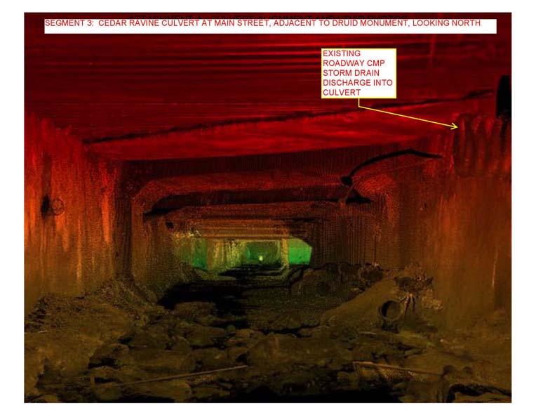
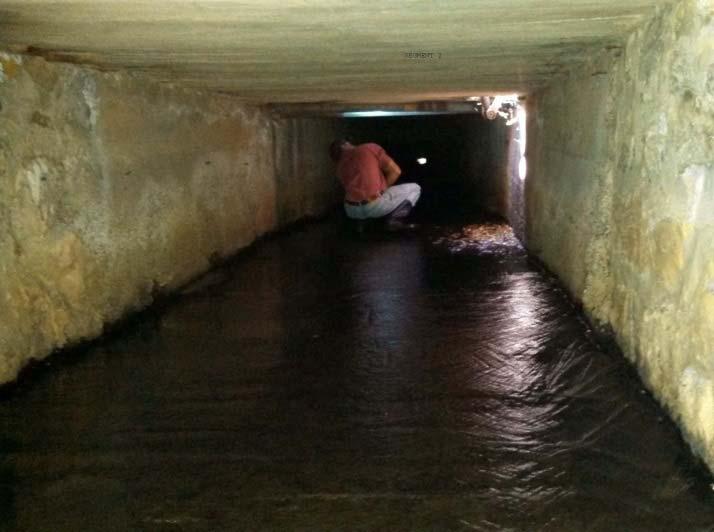
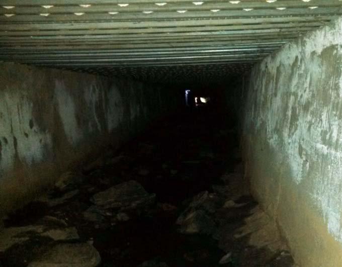
6 What has the City done to monitor and maintain the Cedar Ravine Culvert? Answer: City records indicate repairs of culvert segments have been completed in the 1970 s, 2003, and The most intense of these repairs was in 2003 to reconstruct the bottom of a segment of corrugated metal pipe (CMP) that spans from the concrete bridge archway at Clay Street up to the first manhole located within the Ivy House parking lot. The culvert is monitored regularly through visual inspections. Additionally, as part of the Clay Street Bridge Replacement Project, the City has included an assessment of the culvert that will provide the exact alignment and documenting the condition of the culvert for its entire length. Please see photos of the culvert below taken at various monitoring periods of the culvert, including LiDAR data collected in The City will continue to monitor and inspect the culvert and is considering several options for repairs and/or full replacement of the culvert. As with all aged infrastructure, repair or replacement of the Cedar Ravine Culvert will inevitably be required. Construction methods would likely include excavation and shoring for placement of a new culvert, with particular care for the area adjacent to the Druid Monument. Page 6 of 12

7 Page 7 of 12

8 Page 8 of 12

9 How does the Clay Street Bridge Replacement Project affect the Cedar Ravine Culvert? As mentioned, the outlet to the culvert is located as part of the southern bridge abutment at the existing Clay Street Bridge. Replacement of the bridge would include, at the very least, reconstruction of a segment of the Cedar Ravine Culvert. The segment to be reconstructed is the same segment that was repaired in 2003 (Please see Page 6 of this FAQ). The Clay Street Bridge Project team recently reviewed the culvert s condition and location with respect to various important features within the Clay Street Project footprint, amongst the features discussed included the Druid Monument. A concern over the culvert s remaining useable lifespan and its proximity to the Druid Monument s existing location was specifically discussed as it related to any future reconstruction efforts. The DEIR s mentions the culvert, as stated on page , There is a portion of the existing culvert within close proximity to the Druid Monument. Recent investigation using LIDAR technology indicates the segment close to the monument is in poor condition and could fail, which could impact the monument. The clearance between the Druid Monument and the outside of the existing Cedar Ravine Culvert (with an approximate culvert material thickness of 6 ) is 3. Please see the illustrations on the following page. Page 9 of 12


10 Page 10 of 12 If the realignment alternative for the Clay Street Bridge Replacement Project (as described in the Draft Environmental Impact Report) is selected as the project alternative, it would be methodically and cost efficient to reconstruct the culvert as part of the project once the Druid Monument is temporarily relocated off site, prior to resetting the monument within the intersection at the proposed pedestrian refuge island. Temporarily removing the Druid Monument off site would protect the monument during construction of the new culvert by reducing the risk of complications with excavation, equipment vibration (2 away or less), and shoring of the excavation during removal of the existing culvert structure and construction of
11 the new culvert. The Druid Monument would be moved back to the intersection permanently at the appropriate time when it would be unaffected by construction activities. What happens after Council certifies the Environmental Impact Report (EIR)? Once the public period closes on April 18, 2018, the City will review all written comments received and will prepare the Final EIR with consideration and responses to the comments on the draft document. City Council will then hold a public hearing and make a determination whether to certify the EIR if the EIR is found to be in conformance with the California Environmental Quality Act (CEQA). Following certification of the EIR, the Council will hold a public hearing to consider approval of the project. Since this is a federally funded project, once the EIR is certified, Caltrans, as the National Environmental Policy Act (NEPA) Delegated Reviewer for the Federal Highway Administration (FHWA) will prepare the NEPA document based on the comments received on the Draft EIR and the certified Final EIR. That document will go out for public review this summer (circulation date unknown). Once the NEPA document is finalized, the project will proceed into design. If historical resources are found during construction will they be preserved for future generations? Answer: In addition to the mitigation requirements proposed in the Draft EIR, there will also be language included within the construction contract that protects cultural resources found during construction. This project is federally funded and will be using the 2015 Caltrans Standard Plans and Specifications as the basis for the construction contract. As a standard contract requirement within the Caltrans Standard Specifications, Section 14 2 Cultural Resources and specifically, Subsection Archeological Resources cites the procedures for monitoring an active construction site and statement of procedures if resources are discovered during construction. The resources will be protected or recovered following a field review and evaluation from the archaeological monitor. The specifications referenced can be found at the following link and the City is represented as the Department in the construction contract. ( s/2015_stdspecs.pdf Page 211 of the document) Additionally, Caltrans is requiring a Management Plan that will specifically outline the process and protective measures if any artifact is found during construction. This plan will be reviewed and approved by Caltrans Cultural Staff. The Draft EIR cites references, but they are not attached to the document. Where can I find these references? The Draft Environmental Impact Report, inclusive of all appendices and references can be found here: documents Page 11 of 12
.")
12 Is it necessary to build the new bridge +2 higher to clear creek flows? Answer: The project is federally funded and must comply with federal design guidelines and requirements, mainly the use of American Association of State Highway and Transportation Officials (AASHTO). Per the federal design guidelines and requirements, the new bridge is required to have 2 of freeboard from the water elevation of a 50 year storm and the existing bridge does not meet this requirement. Please see the photo taken from the Clay Street Bridge during the heavy storm of March 22, 2018, classified as only a 10 year event based on rain gauge data and NOAA Atlas 14 Point Precipitation Map. PHOTO TAKEN FROM CLAY STREET BRIDGE, MARCH 22, 2018 STORM Page 12 of 12
PROJECT BACKGROUND. Preliminary Design Scope and Tasks
 PROJECT BACKGROUND Preliminary Design Scope and Tasks The purpose of this Study is the development of preliminary designs for intersection improvements for Trunk Highway (TH) 36 at the intersections of
The Illinois Department of Transportation and Lake County Division of Transportation. Route 173, including the Millburn Bypass
 The Illinois Department of Transportation and Lake County Division of Transportation welcome you to this Public Hearing for U.S. Route 45 from Illinois Route 132 to Illinois Route 173, including the Millburn
PROJECT STATEMENT LOCATION/DESIGN PUBLIC HEARING. 19 th AVENUE NORTH EXTENSION PROJECT FROM SPRINGDALE DRIVE TO NORTH 2 ND STREET/U.S.
 PROJECT STATEMENT LOCATION/DESIGN PUBLIC HEARING 19 th AVENUE NORTH EXTENSION PROJECT FROM SPRINGDALE DRIVE TO NORTH 2 ND STREET/U.S. 67 HEARING LOCATION: ERICKSEN COMMUNITY CENTER 1401 11 TH AVENUE NORTH
WELCOME! 8 8:30 6: TH STREET IMPROVEMENTS. Open House. Presentation & Q&A
 WELCOME! 168 TH STREET IMPROVEMENTS 6:30 Open House 7 8 Presentation & Q&A 8 8:30 Open House WELCOME Todd Pfitzer City of Omaha Engineer Bob Stubbe City of Omaha Public Works Director Jon Meyer Project
ARGENTA TRAIL (CSAH 28/63) REALIGNMENT SOUTH PROJECT (CP 63-25)
 REALIGNMENT SOUTH PROJECT (CP 63-25)") ARGENTA TRAIL (CSAH 28/63) REALIGNMENT SOUTH PROJECT (CP 63-25) Preliminary Design Report February 2015 Prepared For: City of Inver Grove Heights Dakota County Prepared By: Kimley-Horn and Associates,
ARGENTA TRAIL (CSAH 28/63) REALIGNMENT SOUTH PROJECT (CP 63-25) Preliminary Design Report February 2015 Prepared For: City of Inver Grove Heights Dakota County Prepared By: Kimley-Horn and Associates,
INFRASTRUCTURE EXISTING INFRASTRUCTURE A. Circulation B. Signals C. Drainage D. Utilities
 7.01. EXISTING INFRASTRUCTURE A. Circulation B. Signals C. Drainage D. Utilities 7.02. PROPOSED INFRASTRUCTURE A. Overall Concept B. Circulation C. Signals D. Drainage 7.03. INFRASTRUCTURE MAP A. Key Infrastructure
BEST PRACTICES FOR PROJECT NOMINATIONS TA Set-Aside Program
 BEST PRACTICES FOR PROJECT NOMINATIONS 2017 TA Set-Aside Program Focus of this presentation Photos Public Support Maps & Exhibits Proposed Budget Design Details Project Evaluation & Selection Criteria
The transportation system in a community is an
 7 TRANSPORTATION The transportation system in a community is an important factor contributing to the quality of life of the residents. Without a sound transportation system to bring both goods and patrons
Creating Complete Roadway Corridors:
 Creating Complete Roadway Corridors: The AASHTO Guide to Transportation Landscape Architecture and Environmental Design NCHRP Project 15-33 Status Report AASHTO Standing Committee on Design Technical Committee
Beckett Bridge PD& E Study. Presentation to: Board of County Commissioners
 Beckett Bridge PD& E Study Presentation to: Board of County Commissioners October 22, 2013 Introduction Study Began January 2012 Alternatives Presented to Commission October 2013 Alternatives Presented
DESIGN PUBLIC HEARING MAY 10, 2018 GRANBY TOWN HALL FIRST FLOOR CONFERENCE ROOM 10 WEST STATE STREET GRANBY, MASSACHUSETTS 7:00 PM FOR THE PROPOSED
 DESIGN PUBLIC HEARING MAY 10, 2018 AT GRANBY TOWN HALL FIRST FLOOR CONFERENCE ROOM 10 WEST STATE STREET GRANBY, MASSACHUSETTS 7:00 PM FOR THE PROPOSED Reconstruction of Granby Road/West State Street (Route
DRAFT SECTION 4(f) EVALUATION INTERSTATE 73 FEIS: I-95 to I-73/I-74 in North Carolina
 EVALUATION INTERSTATE 73 FEIS: I-95 to I-73/I-74 in North Carolina") DRAFT SECTION 4(f) EVALUATION INTERSTATE 73 FEIS: I-95 to I-73/I-74 in North Carolina 1.0 INTRODUCTION Section 4(f) of the Department of Transportation Act of 1966, 49 U.S.C. 303, requires that prior to
DRAFT SECTION 4(f) EVALUATION INTERSTATE 73 FEIS: I-95 to I-73/I-74 in North Carolina 1.0 INTRODUCTION Section 4(f) of the Department of Transportation Act of 1966, 49 U.S.C. 303, requires that prior to
Meeting Display Boards for Public Hearing on the Wilson Transfer Station Project held Tuesday, February 18, 2014.
 Meeting Display Boards for Public Hearing on the Wilson Transfer Station Project held Tuesday, February 18, 2014. Board 1: Welcome Welcome to the Wilson Transfer Station Project Public Hearing. The purpose
West Dennis Center: Bass River to Old Main Street. West Dennis Business District: Old Main Street to Dennis Commons
 West Dennis Center: Bass River to Old Main Street West Dennis Business District: Old Main Street to Dennis Commons Dennisport Center: Dennis Commons to Division Street Main Street Project Goals Project
THREE-YEAR CAPITAL IMPROVEMENT PLAN FY
 THREE-YEAR CAPITAL IMPROVEMENT PLAN FY2016 2018 Annual CIP Development Process Public Works & Engineering Divisions Prepare List of Capital Needs and Recommended Deferred Maintenance Public Works & Engineering
Project Overview. Fairfax County Parkway Widening Fairfax County. Get Involved. Public Information Meeting. Contact Information
 Get Involved VDOT representatives will review and evaluate information received as a result of this meeting. Please fill out the comment sheet provided in this brochure if you have any comments or questions.
Los Angeles Department of City Planning RECOMMENDATION REPORT
 Los Angeles Department of City Planning RECOMMENDATION REPORT CULTURAL HERITAGE COMMISSION HEARING DATE: April 15, 2010 TIME: 10:00 AM PLACE: City Hall, Room 1010 200 N. Spring Street Los Angeles, CA 90012
COMMUNICATION URBAN DESIGN REVIEW BOARD CITY OF DES MOINES, IOWA MAY 16, 2017 MEETING
 COMMUNICATION URBAN DESIGN REVIEW BOARD CITY OF DES MOINES, IOWA MAY 16, 2017 MEETING Subject: Recommendation Prepared by: PRELIMINARY DESIGN REVIEW OF LOCUST STREET BRIDGE CONSTRUCTION & COURT AVENUE,
City of Larkspur. Notice of Mitigated Negative Declaration for the 285
 Notice of Mitigated Negative Declaration for the 285 Magnolia Avenue Mixed-Use Project Date: December 2, 2013 Responsible Agency: Project Title: 285 Magnolia Avenue Mixed-Use Project Project Address: 285
SAN MARTIN BOULEVARD OVER RIVIERA BAY PROJECT DEVELOPMENT & ENVIRONMENT (PD&E) STUDY
 STUDY") KICK-OFF PRESENTATION SAN MARTIN BOULEVARD OVER RIVIERA BAY PROJECT DEVELOPMENT & ENVIRONMENT (PD&E) STUDY PROJECT IDENTIFICATION NUMBER (PID): #001036A May 13, 2015 1 2 PROJECT LOCATION PROJECT HISTORY
KICK-OFF PRESENTATION SAN MARTIN BOULEVARD OVER RIVIERA BAY PROJECT DEVELOPMENT & ENVIRONMENT (PD&E) STUDY PROJECT IDENTIFICATION NUMBER (PID): #001036A May 13, 2015 1 2 PROJECT LOCATION PROJECT HISTORY
Welcome. Date: Thursday March 2, 2017 Time: 6:30 p.m. 9:00 p.m. Location: Woodview School Gym, 69 Flatt Road, Burlington Presentation Time: 7:00 p.m.
 Welcome Public Information Centre No.2 City of Burlington, City of Hamilton, Region of Halton Waterdown Road Widening Detailed Design Craven Avenue to Mountain Brow Road Date: Thursday March 2, 2017 Time:
California Environmental Quality Act (CEQA) Environmental Review Process
 Environmental Review Process") California Environmental Quality Act (CEQA) Environmental Review Process Los Angeles Union Station Forecourt and Esplanade Improvements constitute a Project Los Angeles County Metropolitan Transportation
California Environmental Quality Act (CEQA) Environmental Review Process Los Angeles Union Station Forecourt and Esplanade Improvements constitute a Project Los Angeles County Metropolitan Transportation
Project Overview. Get Involved. Public Information Meeting. Contact Information
 Get Involved VDOT representatives will review and evaluate information received as a result of this meeting. Please fill out the comment sheet provided in this brochure if you have any comments or questions.
2040 Long Range Transportation Plan
 2040 Long Range Transportation Plan Adopted: April 15, 2013 APPENDIX D HIGHWAY NEEDS PLAN PROJECTS FREDERICKSBURG Existing and Committed Projects Fall Hill Avenue/Mary Washington Blvd. (Fredericksburg)
COMMUNITY DEVELOPMENT SERVICES PLANNING AND BUILDING DEPARTMENT PLACERVILLE OFFICE:
 COMMUNITY DEVELOPMENT SERVICES PLANNING AND BUILDING DEPARTMENT http://www.edcgov.us/devservices/ PLACERVILLE OFFICE: LAKE TAHOE OFFICE: 2850 Fair Lane Court, Placerville, CA 95667 924 B Emerald Bay Rd.
Welcome. to the 95th Street Terminal Improvement Project Public Hearing
 Welcome to the 95th Street Terminal Improvement Project Public Hearing The purpose of this Public Hearing is to solicit comments from the community about the Environmental Assessment prepared for the 95th
RESOLUTION NO. R Refining the route, profile and stations for the Downtown Redmond Link Extension
 RESOLUTION NO. R2018-32 Refining the route, profile and stations for the Downtown Redmond Link Extension MEETING: DATE: TYPE OF ACTION: STAFF CONTACT: Capital Committee Board PROPOSED ACTION 09/13/2018
Eastside Transit Corridor Phase 2 Technical Study Update Community Outreach Meeting February 2017
 Eastside Transit Corridor Phase 2 Technical Study Update Community Outreach Meeting February 2017 Purpose of Tonight s Meeting Recap of Board motion (2014) and technical study process Provide update on
Description of Preferred Alternative
 Chapter 2 Description of Preferred Alternative 2.1 Introduction This chapter of the programmatic Sammamish Town Center Sub-area Plan Final EIS provides a more detailed description of the Preferred Alternative
4.1 Build Alternative 1 Construction Phasing
 SECTION 4 Implementation Plan This section discusses potential segmentation of the build alternatives into multiple projects for implementation of improvements to the NSH from Rabbit Creek Road to 36th
2 ALTERNATIVES AND OPTIONS
 2 ALTERNATIVES AND OPTIONS This chapter documents the process used to develop improvement concepts for Oregon Avenue and describes the resulting project alternatives and options, which were developed in
Welcome. Northern Segment of Hwy 100 I-90 to South of Madison Street Meeting Goals:
 Welcome Northern Segment of Hwy 100 I-90 to South of Madison Street Meeting Goals: - Review Environmental Assessment - Share Preferred Alternative -Receive Public Comments 2003 EA Preferred Alternative
NOTICE OF PREPARATION
 NOTICE OF PREPARATION To: All Interested Parties Subject: Notice of Preparation of an Environmental Impact Report From: City of Petaluma Address: 11 English Street, Petaluma, CA 94952-2610 Contact: Heather
Alternatives Development Three conceptual alternatives were developed for the Race Road/Jessup Village Planning Study and are described below:
 Race Road/Jessup Village Planning Study (H550601) Project Newsletter Spring 2015 Project Description The Study Team, consisting of staff from Anne Arundel County (Department of Public Works and Department
Open House Public Involvement Meeting Howland High School Cafeteria, 200 Shaffer Drive NE, Warren, Ohio. Informational Handout
 Open House Public Involvement Meeting Howland High School Cafeteria, 200 Shaffer Drive NE, Warren, Ohio SR 46 (Niles Cortland Road) and SR 82 Proposed Improvements Howland Township, Trumbull County, Ohio
PROJECT UPDATE BON AIR ROAD BRIDGE REPLACEMENT AND MAGNOLIA AVENUE WATER QUALITY FACILITIES
 CITY OF LARKSPUR PROJECT UPDATE BON AIR ROAD BRIDGE REPLACEMENT AND MAGNOLIA AVENUE WATER QUALITY FACILITIES PRESENTED BY Julian Skinner Larkspur Public Works Director DATE July 13, 2016 Bon Air Bridge
Appendix E Preliminary Location Hydraulic Study
 Appendix E Prepared for: State of Alaska Department of Transportation and Public Facilities Prepared by: HDR Alaska, Inc. 2525 C Street, Suite 305 Anchorage, Alaska 99503 February 2014 This page intentionally
Public Hearing. Charlotte County-Punta Gorda MPO - Meeting Rooms A and B March 14, open house at 4 p.m., formal presentation at 5 p.m.
 Public Hearing Charlotte County-Punta Gorda MPO - Meeting Rooms A and B March 14, 2019 open house at 4 p.m., formal presentation at 5 p.m. Welcome to the Public Hearing for the Harborview Road (CR 776)
Bucks Bar Road Bridge Project Public Informational Meeting Wednesday, January 6, 2010
 PRESENTED BY: Bucks Bar Road Bridge Project Public Informational Meeting Wednesday, January 6, 2010 Matthew Smeltzer, P.E. Deputy Director of Engineering, DOT Supervisor Ray Nutting El Dorado County, District
SR-2 Freeway Terminus Improvement Project
 SR-2 Freeway Terminus Improvement Project Welcome! Public Hearing, Mayberry Elementary June 16, 2009, 6:30 p.m. 8:30 p.m. Agenda 6:30 PM 6:50 PM Registration and Open House 6:50 PM 7:00 PM Welcome and
City of Bristol Route 6 Corridor Implementation Program
 City of Bristol Route 6 Corridor Implementation Program FITZGERALD & HALLIDAY, INC. Innovative Planning, Better Communities June 2017 Route 6 Corridor Plan IMPLEMENTATION PROGRAM The following Implementation
WELCOME TO OPEN HOUSE TWO November 28, 2018
 Langstaff Road Weston Road to Highway 7 Class Environmental Assessment Study WELCOME TO OPEN HOUSE TWO November 28, 2018 Please sign in and join our mailing list Study Overview York Region is conducting
Derby-Shelton Bridge Pedestrian and Bicyclist Enhancements [1]
![Derby-Shelton Bridge Pedestrian and Bicyclist Enhancements [1]](/thumbs/96/128011958.jpg "Derby-Shelton Bridge Pedestrian and Bicyclist Enhancements [1]") nhancements [1] STATUS OF PROJECT: The project has recently moved from the Preliminary Design Phase to the Final Design Phase following the most recent Public Involvement Meeting held on January 9, 2019
nhancements [1] STATUS OF PROJECT: The project has recently moved from the Preliminary Design Phase to the Final Design Phase following the most recent Public Involvement Meeting held on January 9, 2019
AGENDA ACTION ITEMS INFORMATION ITEMS
 NOACA Bicycle and Pedestrian Advisory Council Meeting Friday, March 21 st, 2014 10:30 a.m. NOACA Office 1299 Superior Avenue Cleveland, Ohio 44114 Phone: (216) 241-2414; website: www.noaca.org AGENDA ACTION
SOUTHEAST AREA SPECIFIC PLAN. Planning Commission Study Session August 18, 2016
 SOUTHEAST AREA SPECIFIC PLAN Planning Commission Study Session August 18, 2016 Background: How did we get here? Directed by City Council to prepare Specific Plan (2012) Sustainability focused grant from
Fall 2017 Construction Update
 Fall 2017 Construction Update Ward 4 Southeast Engineering Department Riverwalk Red Multi-Use Trail Bridge Rehabilitation The Riverwalk Red Multi Use Trail Bridge was awarded to Cramer and Associates,
DESIGN CRITERIA PACKAGE
 RFQ: 17-C-00003 DESIGN-BUILD SERVICES FOR THE DESIGN CRITERIA PACKAGE PREPARED BY: JAMES E. JACKSON, JR. AIA CITY ARCHITECT CONTRACT ADMINISTRATION DEPARTMENT and INTERFLOW ENGINEERING, L.L.C DESIGN CRITERIA
A. WHAT IS A GENERAL PLAN?
 I. Introduction A. WHAT IS A GENERAL PLAN? A general plan is the planning guideline for the future of a city. It contains goals and policies which regulate urban development, the protection of the natural
July 12, Columbus City Council City Hall 90 West Broad Street Columbus, OH RE: I-70/71 Columbus Crossroads Project
 OHIO DEPARTMENT OF TRANSPORTATION DISTRICT 6 400 EAST WILLIAM STREET DELAWARE, OHIO 43015 800.372.7714 Columbus City Council City Hall 90 West Broad Street Columbus, OH 43215-9015 RE: I-70/71 Columbus
North Carolina Department of Transportation Project Development and Environmental Analysis Branch
 North Carolina Department of Transportation Project Development and Environmental Analysis Branch Citizens Informational Workshop I-85, from I-485 to NC 73 Mecklenburg and Cabarrus Counties October 30,
IOWA HIGHWAY 57 / WEST 1 ST STREET STUDY PUBLIC INFORMATIONAL MEETING APRIL 22, 2014
 IOWA HIGHWAY 57 / WEST 1 ST STREET STUDY PUBLIC INFORMATIONAL MEETING APRIL 22, 2014 INTRODUCTION The City of Cedar Falls and the Iowa Department of Transportation are conducting a Public Informational
Bypass #16 - Bend Parkway (new alignment for US 97) (MP )
 (MP )") Bypass #16 - Bend Parkway (new alignment for US 97) (MP 134.76-141.83) Description: The Parkway is on new alignment for US 97 through Bend. US 97 is a Statewide Highway on the National Highway System that
Bypass #16 - Bend Parkway (new alignment for US 97) (MP 134.76-141.83) Description: The Parkway is on new alignment for US 97 through Bend. US 97 is a Statewide Highway on the National Highway System that
Community Workshop. City of Richmond. January 25, 2011 SF Bay Trail Connection - Castro St to Richmond-San Rafael Bridge
 Community Workshop City of Richmond 1 City of Richmond Lead Agency BPAC Richmond Community ABAG Design and Process Funding Partner Caltrans Environmental; Process Review Design Process State and Federal
2.1.8 Cultural Resources Regulatory Setting. Affected Environment, Environmental
 REVISED DRAFT ENVIRONMENTAL IMPACT REPORT/ Affected Environment, Environmental 2.1.8 Cultural Resources This section evaluates the potential for historical and archaeological resources within the proposed
PREPARED FOR: PLATTEVIEW ROAD CORRIDOR STUDY EXECUTIVE SUMMARY
 PREPARED FOR: PLATTEVIEW ROAD CORRIDOR STUDY EXECUTIVE SUMMARY SEPTEMBER 2016 Introduction The Platteview Road Corridor Study was led by the Metropolitan Area Planning Agency (MAPA) with assistance from
REPORT TO: Council FOR: Regular Meeting. PRESENTED: April 1, 2008 FILE: , Byl 1932 & 1936
 DISTRICT OF SQUAMISH REPORT TO: Council FOR: Regular Meeting PRESENTED: April 1, 2008 FILE: 2006-08, Byl 1932 & 1936 DEPARTMENT: Planning Department SUBJECT: First and Second Readings for Bylaws 1932 (rezoning)
Reconfiguration of The Six Points Interchange. Community Update #2 June 18, 2014
 Reconfiguration of The Six Points Interchange Community Update #2 June 18, 2014 Outline 1. Project overview 2. How did we get here? 3. Etobicoke Centre 4. Existing and future road network 5. Design Update
Municipality of Anchorage. Community Council Survey Capital Projects Needs Ranking Survey (ALPHABETICAL) Airport Heights
 Airport Heights") ANCHORAGE PARKS & RECREATION Nichols Park Design and improve neighborhood park 2008 Challenge Grant applicant. 2008 $500K State Grant for Neighborhood Parks. Tikishla Park Lighting, paved parking, hockey
ANCHORAGE PARKS & RECREATION Nichols Park Design and improve neighborhood park 2008 Challenge Grant applicant. 2008 $500K State Grant for Neighborhood Parks. Tikishla Park Lighting, paved parking, hockey
ALTERNATIVES. NCDOT made an early decision to first determine how to build the project (construction method) followed by what to build (alternatives).
 followed by what to build (alternatives).") III. ALTERNATIVES A. CONSTRUCTION METHOD ALTERNATIVES NCDOT made an early decision to first determine how to build the project (construction method) followed by what to build (alternatives). One of the
III. ALTERNATIVES A. CONSTRUCTION METHOD ALTERNATIVES NCDOT made an early decision to first determine how to build the project (construction method) followed by what to build (alternatives). One of the
Appendix G Response to Comments
 Appendix G Response to Comments This appendix contains the comments received during the public circulation and comment period (May 27, 2008 to July 11, 2008). The comments have been numbered (Comment Set
Route 66 Business Corridor
 Route 66 Business Corridor DOWNTOWN BUSINESS AND CULTURAL DISTRICT SPECIFIC PLAN Draft April 2016 Acknowledgments Text Acknowledgments here etc... LIST NAME List List List Table of Contents 1. Introduction...
BEST PRACTICES FOR DETAILED APPLICATIONS TA/SRTS Program
 BEST PRACTICES FOR DETAILED APPLICATIONS 2019 TA/SRTS Program Criteria Evaluation Categories (Program Guide Table 3) Safety Connectivity & Accessibility Quality of Life Economic Development Encouragement
Section 4(f) De Minimis Memorandum for the Hickman Road over Tuolumne River Bridge Replacement Project (Bridge No. 38C 0004)
 De Minimis Memorandum for the Hickman Road over Tuolumne River Bridge Replacement Project (Bridge No. 38C 0004)") 11060 White Rock Road, Suite 200 Rancho Cordova, CA 95670 Phone: (916) 363 4210 Fax: (916) 363 4230 M e m o r a n d u m To: Julie Myrah, Branch Chief Date: May 5, 2017 California Department of Transportation
11060 White Rock Road, Suite 200 Rancho Cordova, CA 95670 Phone: (916) 363 4210 Fax: (916) 363 4230 M e m o r a n d u m To: Julie Myrah, Branch Chief Date: May 5, 2017 California Department of Transportation
Supporting our communities. Bridges
 Supporting our communities Bridges 1,000+ We ve partnered with thousands of owners/clients to inspect, analyze, design, and manage their bridges, providing lasting community connections. We design bridges
SBCAG STAFF REPORT. MEETING DATE: March 17, 2016 AGENDA ITEM: 5I
 SBCAG STAFF REPORT SUBJECT: Cabrillo-UPRR Bridge Project MEETING DATE: March 17, 2016 AGENDA ITEM: 5I STAFF CONTACT: Fred Luna RECOMMENDATION: Authorize the chair to sign a Memorandum of Understanding
Services Department F May 28, 2007
 Report To: Development Services Committee Item: Date of Report: From: DS-07-144 May 23, 2007 Commissioner, Development File: Date of Meeting: Services Department F-7000-0013 May 28, 2007 Subject: Gibb
7.0 DRAFT SECTION 4(f) EVALUATION
 EVALUATION") 7. DRAFT SECTION 4(f) EVALUATION 7.1 Background Information and Regulatory Requirements This chapter presents the existing conditions and potential effects on parks, recreation areas, wildlife and waterfowl
7. DRAFT SECTION 4(f) EVALUATION 7.1 Background Information and Regulatory Requirements This chapter presents the existing conditions and potential effects on parks, recreation areas, wildlife and waterfowl
Project Study Report Equivalent The Old Road Widening SIX FLAGS MAGIC MOUNTAIN. On Street The Old Road Between Magic Mountain Pkwy And Turnberry Lane
 Project Study Report Equivalent The Old Road Widening SIX FLAGS MAGIC MOUNTAIN On Street The Old Road Between Magic Mountain Pkwy And Turnberry Lane On Street Henry Mayo Drive Between The Old Road And
REGIONAL TRANSPORTATION COMMISSION OF SOUTHERN NEVADA AGENDA ITEM
 REGIONAL TRANSPORTATION COMMISSION OF SOUTHERN NEVADA AGENDA ITEM Metropolitan Planning Organization [ X ] Transit [ ] Administration and Finance [ ] SUBJECT: PROJECT SELECTION PROCESS FOR TRANSPORTATION
Old Town Neighborhoods Plan. Choices Event Wednesday, December 9, 2015
 Old Town Neighborhoods Plan Choices Event Wednesday, December 9, 2015 Agenda 6:00 6:10 p.m. Welcome + Sign In 6:10 6:30 p.m. Presentation 6:30 8:00 p.m. Workshop + Open House Seeking your input on: Neighborhood
Asbury Chapel Subdivision Sketch Plan
 Asbury Chapel Subdivision Sketch Plan PART 1: PROJECT SUMMARY Applicant: NVR Inc. Project Size: +/- 76.13 acres Parcel Numbers: 02101112,02116101,02116112, 02116113 Current Zoning: Transitional Residential
Reconnecting New Haven: Downtown Crossing
 Reconnecting New Haven: Downtown Crossing Phase 2 Update Introduction to Phase 3 November 16, 2017 City of New Haven, Connecticut Toni N. Harp, Mayor Reconnecting New Haven Introduction Project Overview
Berkshire Regional Planning Commission Clearinghouse Review Report
 August 19, 2013 SUBJECT: Reconstruction of Housatonic Street, Dalton, MA EOEA#: 15083 LOCATION: Dalton ESTIMATED COST: $8.1 million REVIEW TYPE: ENF PROPONENT: MassDOT and Town of Dalton COMMENTS DUE:
STATE OF TENNESSEE DEPARTMENT OF TRANSPORTATION ENVIRONMENTAL DIVISION
 STATE OF TENNESSEE DEPARTMENT OF TRANSPORTATION ENVIRONMENTAL DIVISION Suite 900 - James K. Polk Building 505 Deaderick Street Nashville, Tennessee 37243-0334 MEMORANDUM TO: FROM: Files Joe W. Matlock,
I-90 Mississippi River Bridge & Interchange Project
 I-90 Mississippi River Bridge & Interchange Project Presentation Outline I. Background: Context & Need for Project II. Preferred Alternative Overview III. Project Development IV. Project Management Tools
Capital Projects impacting Odenton Town Center
 Capital Projects impacting Odenton Town Center 1 2 E549700 W801600/ W801602 Anne Arundel County Department of Public Works Manor View Elementary School Transmission Main - MD 32 @ Meade Phase 2 $34,399,000
Rezoning Issues Setting a Foundation for Zoning Decisions
 Rezoning Issues Setting a Foundation for Zoning Decisions City Council Workshop May 2, 2016 Agenda Goal Need actionable items and sequence of steps Foundation for Zoning Decisions Council Workshop Discussion
DRAFT MAP AMENDMENT FLU 04-4
 DRAFT MAP AMENDMENT FLU 04-4 SW 24 TH AVENUE ROADWAY CORRIDOR The University of Florida participates with the Metropolitan Transportation Planning Organization (MTPO) in its responsibilities for the continuing,
VALLEY COUNTY MINIMUM STANDARDS FOR PRIVATE ROAD DESIGN AND CONSTRUCTION
 MINIMUM STANDARDS FOR PRIVATE ROAD DESIGN AND CONSTRUCTION Adopted November 28, 2005 TABLE OF CONTENTS DEFINITION OF TERMS...II I. DESIGN CRITERIA... 1 A. GENERAL DESIGN CRITERIA... 1 B. ROADWAY CLASSIFICATION...
Public Information Centre. Welcome
 Transportation Improvements from the Beaver Creek Bridge to the Entrance of Santa s Village District of Muskoka Municipal Class Environmental Assessment Welcome Please sign in Take a comment sheet Staff
NOTICE OF AVAILABILITY (NOA) OF A DRAFT ENVIRONMENTAL IMPACT REPORT AND NOTICE OF PUBLIC HEARING 2190 Shattuck Avenue Mixed-Use Project
 OF A DRAFT ENVIRONMENTAL IMPACT REPORT AND NOTICE OF PUBLIC HEARING 2190 Shattuck Avenue Mixed-Use Project") Planning and Development Department Land Use Planning Division NOTICE OF AVAILABILITY (NOA) OF A DRAFT ENVIRONMENTAL IMPACT REPORT AND NOTICE OF PUBLIC HEARING 2190 Shattuck Avenue Mixed-Use Project Notice
Planning and Development Department Land Use Planning Division NOTICE OF AVAILABILITY (NOA) OF A DRAFT ENVIRONMENTAL IMPACT REPORT AND NOTICE OF PUBLIC HEARING 2190 Shattuck Avenue Mixed-Use Project Notice
S SUMMARY S.1 PREFACE S.2 PURPOSE AND NEED S.3 PROJECT BACKGROUND
 S SUMMARY S.1 PREFACE The Federal Highway Administration (FHWA) and the District Department of Transportation (DDOT), in cooperation with the National Park Service (NPS), are proposing the rehabilitation
HISTORIC BRIDGES IN CRAWFORD COUNTY. Bridges Listed on the National Register of Historic Places in Crawford County
 Arkansas State Highway and Transportation Department HISTORIC BRIDGES IN CRAWFORD COUNTY Bridges Listed on the National Register of Historic Places in Crawford County 2004 Arkansas State Highway and Transportation
Pennsy Greenway Trail
 Town of Schererville Pennsy Greenway Trail DES. #s: 0401062, 1173595 & 1382661 Construction of Pennsy Greenway Trail beginning at Wilhelm Street and continuing northwest along the former Penn Central railroad
SAN RAFAEL GENERAL PLAN 2040 INTRODUCTION AND OVERVIEW
 SAN RAFAEL GENERAL PLAN 2040 INTRODUCTION AND OVERVIEW Steering Committee Presentation February 14, 2018 Purpose of General Plan Guide land use and development decisions Coordinate transportation, infrastructure,
SECTION 5 - SCENIC HIGHWAYS
 SECTION 5 - SCENIC HIGHWAYS INTRODUCTION The California State Scenic Highways Program was established by the State Legislature through Senate Bill No. 1467 (Farr) in 1963. This Bill established the Scenic
Cottage Grove Road Reconstruction. City of Madison Engineering
 Public Informational Meeting Cottage Grove Road Reconstruction October 8, 2015 Presentation Outline Introduction Project Purpose & Need Proposed Design Overview Environmental Concerns Pedestrian Needs
CTH C RESURFACING Douglas County, Wisconsin
 Krech Ojard s Civil Group provides full range design and construction management services for municipal transportation and utility projects, as well as a variety of private developments. With a staff possessing
Capital Projects in and near Odenton Town Center
 Capital Projects in and near Odenton Town Center Map ID Anne Arundel County Department of Public Works This project provides for the design, right of way acquisition, and construction of approximately
Glenn Highway MP DSR. Landscape Narrative
 Glenn Highway MP 34-42 DSR Landscape Narrative Project Landscape Goals The Glenn Highway MP 34-42 Project extends through a variety of landscape types typical to the Matanuska-Susitna Valley. In general,
TORONTO COMPLETE STREETS GUIDELINES
 TORONTO COMPLETE STREETS GUIDELINES Presentation by Fiona Chapman, Manager, Pedestrian Projects Public Realm Section, Transportation Services, City of Toronto June 2017 PURPOSE OF THE PROJECT To develop
Chapter 1 - General Design Guidelines CHAPTER 1 GENERAL DESIGN GUIDELINES
 CHAPTER 1 GENERAL DESIGN GUIDELINES 1.0 INTRODUCTION This Publication has been developed to provide current, uniform procedures and guidelines for the application and design of safe, convenient, efficient
SH 199 Corridor Master Plan. Community Meeting No. 2 May 31, 2017
 Community Meeting No. 2 May 31, 2017 Transportation Projects On or Near SH 199 SH 199 from 0.3 miles south of FM 1886 to south end of Lake Worth bridge Construct freeway mainlanes and frontage roads 10-Year
Commissioners Road West Realignment Environmental Assessment
 City of London Commissioners Road West Realignment Environmental Assessment Public Information Centre No. 1 March 30, 2017 Welcome to the Public Information Centre This first Public Information Centre
The purpose of tonight s PIC is to:
 The purpose of tonight s PIC is to: Provide an overview of the work completed to date and a summary of the Class EA process being followed; Provide a summary of public input received so far, including
Northwest Rail Corridor and US 36 BRT Development Oriented Transit Analysis 4.4 STATION AREA FINDINGS
 4.4 STATION AREA FINDINGS Each station is different, and each one requires a separate set of recommendations based on the vision for the site. This section outlines an initial TOD strategy and recommendations
PUBLIC HEARING. DRAFT Environmental Impact Statement. Matthews Memorial Baptist Church Washington, DC October 18, National Capital Region
 National Capital Region DRAFT Environmental Impact Statement PUBLIC HEARING Matthews Memorial Baptist Church Washington, DC October 18, 2007 Introduction Welcome and team introduction Hearing procedures
Highway 427 Industrial Secondary Plan Area 47 Schedule C Class Environmental Assessment For Arterial Roadways
 Welcome to Pubic Information Centre #1 Highway 427 Industrial Secondary Plan Area 47 Schedule C Class Environmental Assessment For Arterial Roadways Welcome to Open House # 1 Tonight, we invite you to.
Section 4.11 Traffic and Transportation 4.11 TRAFFIC AND TRANSPORTATION
 4.11 TRAFFIC AND TRANSPORTATION The following sections summarize the evaluation of the potential traffic/transportation impacts of the San Gabriel River Corridor Master Plan. First, the analysis methodology
I-70 Corridor Enhancement Plan
 i - Table of Contents Table of Contents Chapter I Overview Chapter II Bridge and Roadway Improvements Chapter III Landscape Enhancements Chapter IV Riparian Corridors Chapter V Showcase Missouri Plan Chapter