DESIGN WORKSHOP. November 17, 2015
|
|
|
- Beverley Carter
- 5 years ago
- Views:
Transcription


1 DESIGN WORKSHOP November 17, 2015
2 needs more housing. But there is no one-size fits-all solution. Every neighborhood has its own character. In some places, density is not only appropriate it is badly - Mayor Martin J. Walsh

3 AGENDA WHY WE RE HERE 1 Plan Overview WHA WE VE HEARD 2 Values & Priorities 3 Streets & Blocks 4 Uses & Location 5 Open Space Strategy HOW DO WE GE O WHERE WE WAN O BE? 6 Zoning ools for Implementation 7 Urban Design ools for Implementation 8 Rationale for Future Development ALK O US 9 Pros and Cons Design Exercise Andrew Broadway

4 PLAN Overview alk to Us open house July 30, 2015
5 PLAN CALENDAR JULY 30, 2015 alk to Us Open House SEPEMBER 14, 2015 Walk and Bike With Us Study Area ours OCOBER 1, 2015 Imagine with Us Visioning Workshop OCOBER 26, 2015 Plan with Us Streets & Blocks, Land Use Workshop NOVEMBER 17, 2015 Design With Us Height & Density, Open Space Workshop DECEMBER 14, 2015 What We Heard Recap Session/Dialogue JANUARY Choose with Us Plan Scenarios Session FEBRUARY Discuss with Us Preferred Plan Draft Session MARCH Plan Production (Internally BRA Staff Draft Plan Document) APRIL Finalize with Us Final Plan Presentation MAY & JUNE Internally BRA Staff Draft Zoning Documents & Zoning Commission Meeting

6 OPEN HOUSE COMMENS July 30, 2015 Have places for middle class families to stay and thrive in South Boston. Green Space! ake the focus off personal use vehicles + improve transit options. It's not 1950s. Worker housing that young professionals can realistically afford Cyclist safety and comfort on this major route into downtown.

7 WALK AND BIKE OURS COMMENS September 14, 2015 Open space needs to be looked at in the study area. If mixed use projects are being built, open space needs to be part of the overall vision. I would also like to see some of the industrial character of the avenue preserved... Boston is proud of its history, and we should preserve it when at all possible. More connecting streets and a possible new grid pattern needs to be looked at carefully to allow traffic to flow through the area and for pedestrians.


8 VISIONING WORKSHOP October 1, 2015


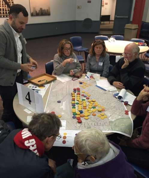
9 PLAN WIH US WORKSHOP Planning Exercise

10 Values and Priorities Imagine with Us workshop October 1, 2015
11 VALUES AND PRIORIIES WE HEARD Summary A neighborhood with amenities Retail and other services Civic/Cultural/Art spaces New and varied open spaces A walkable neighborhood with improved public transportation Walkable sidewalks and bikeable streets Less traffic congestion Cycling opportunities for people of all ages A diversity of housing types Live/work opportunities all apartment buildings Smaller housing units preserving existing character

12 Plan with Us workshop October 26, 2015 Streets & Blocks
13 NEWORK/ CONNECIVIY Envisioned Future Network Initial Ideas by City Planning Staff for Community Feedback Provide capacity and connectivity for future uses Avoid contributing to (and help improve) existing congestion hot spots Make important connections to outside the study area he roads shown are conceptual and intended to illustrate a suggested network. Each location, layout, and dimension to be determined through this planning process. Break down scale for improved urban design and walkability City/BRA will not be pursuing the acquisition of private property to build streets and connections Network will be built out over time only in conjunction with private development
14 NEWORK/ CONNECIVIY Example of Envisioned Future Phasing Initial Ideas by City Planning Staff Where possible, new connections envisioned along property lines, utilizing existing rights-of-way and avoiding existing structures he phasing shown is conceptual and intended to illustrate an idea for phased development in the future. he roads shown are conceptual and intended to show a suggested network.
15 COMMUNIY FEEDBACK Based on Plan With Us Workshop Connection to South Boston Bypass/Haul Road adjusted Additional suggestions made are more suitable to future formal and detailed design review processes, such as: Breaking up of blocks with additional connections Detailed intersection design and roadway geometries he roads shown are conceptual and intended to illustrate a suggested network. Each location, layout, and dimension to be determined through this planning process. New streets not to be built in lieu of complete streets improvements to existing roads

16 Land Uses and Locations Plan with Us workshop October 26, 2015


17 ABLE 1 Images and Notes Create gateway nodes Create a 21 st century Broadway Create mixed-use everywhere

18 ABLE 3 Images and Notes Necklace of open space from Broadway to Moakley Park Preserve residential in historic Andrew Square Limited concentrated light industrial

19 ABLE 4 Images and Notes A cultural center should be closer to either Andrew or Broadway stations Small parks scattered throughout Diversity of housing important

20 ABLE 5 Images and Notes More density at train stations, emphasis on office Encourage as much retail as possible Central large green space smaller parks near existing neighborhood

21 ABLE 7 Images and Notes Key principle: Dorchester Ave is a community street Larger park equally distant from stations Civic space adjacent to green areas

22 ABLE 8 Images and Notes D Street a through street, neighborhood street Greenway on Ellery Street to Alger street Rethink bus circulation around Andrew stop

23 ABLE 9 Images and Notes Very limited industrial all along the tracks Open space evenly distributed Almost all mixed-use except extreme north and south

24 ABLE 10 Images and Notes Emphasis on north-south connections New connection to Bypass raffic going to waterfront should use bypass road
25 WHA WE SAW - SUMMARY Most Common hemes from Land Use Exercise Open Space Distribution of open space with larger parcels west of Dorchester Ave Civic/Cultural Civic uses concentrated in 2-3 locations in proximity to residential uses/transit nodes Mixed-Uses Mixed uses North-South along tracks Creation of North and South gateways through a higher density and concentration of uses Residential Significant increase in residential uses across study area Industrial Significant reduction in industrial uses Industrial uses distributed along the tracks Retail/Services Ground floor amenities and retail along corridors
26 LAND USE CONCEP Significant increase in residential uses across study area his concept is informed by the input
27 LAND USE CONCEP Distribution of open space with larger parcels west of Dorchester Ave his concept is informed by the input
28 LAND USE CONCEP Creation of North and South gateways through higher density and concentration of uses. his concept is informed by the input
29 LAND USE CONCEP Ground floor amenities and retail along corridors his concept is informed by the input
30 LAND USE CONCEP Industrial uses distributed along the tracks his concept is informed by the input

31 Open Space Strategies

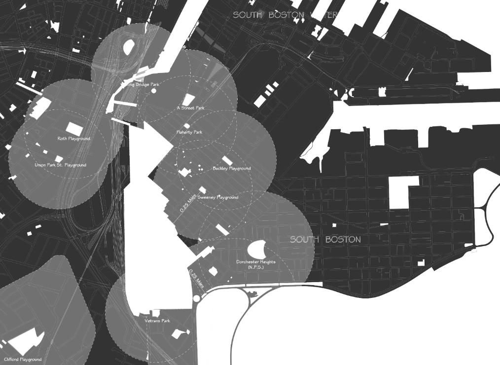
32 PARK ¼ MILES WALK ZONE

33 LINEAR OPEN SPACE Back Bay Scale Comparison Observations Provides connectivity to larger open spaces Small, linear nature limits the type of programming to a passive recreation May be challenging to implement


34 ANCHOR OPEN SPACES South Boston Scale Comparison Observations Provides a larger overall green space, which allows for greater flexibility in program Providing access and connection between open spaces becomes a higher priority Large scale open space will compete with development pressure

35 NEIGHBORHOOD NEWORK South End Scale Comparison Observations Provides a variety of spaces and sizes for program More equally distributes open space through the district ake advantage of hard to develop parcels where pieces of the network get developed as the district develops

36 OPEN SPACE CONCEPS Linear Open Space Concept Neighborhood Open Space concept

37 Zoning ools for Realizing Benefits Harrison/Albany Precedent
38 SHARED PRIORIY BENEFIS Provided by Private Development Create new streets and sidewalks Create public open space Create middle income housing Create affordable neighborhood retail/amenities Create affordable commercial space Create new 21 st century industrial space for artists/entrepreneurs Create affordable civic/cultural/art space Create highly energy efficient buildings (LEED Gold and higher)
39 What zoning tools were used in Harrison Albany Corridor Study to incentivize benefits?

40 HARRISON-ALBANY CORRIDOR PLANNING SUDY South End, 2012 OVERVIEW Harrison Albany Corridor was mostly comprised of commercial and light industrial uses similar to PLAN: So Boston Study Area he planning study created an opportunity to think strategically about the types of uses, public realm, and the scale of development that were best suited for the Corridor
41 HARRISON-ALBANY SUDY Zoning ools LO COVERAGE o achieve a pedestrian friendly public realm: Limit development footprint to 80% of the lot 20% of the lot to be designed and built to ensure public access or enhance the pedestrian experience

42 HARRISON-ALBANY SUDY Zoning ools LO COVERAGE & BUILDING SE BACKS SE BACK SE BACK

43 HARRISON-ALBANY SUDY Zoning ools LO COVERAGE & BUILDING SE BACKS SE BACK SE BACK


44 HARRISON-ALBANY SUDY Height and Density Existing heights Proposed heights
45 HARRISON-ALBANY SUDY Zoning ools BENEFIS IN EXCHANGE FOR BONUSES 20% Affordable Housing (13% of projects residential units are required under Boston s Inclusionary Development Policy) OR Affordable Cultural Space 5% of the bonus square footage to be dedicated to non-profit cultural entity OR Affordable Commercial Space 5% of the bonus square footage must be provided to a start-up business or its equivalent value must be provided to a program or loan fund OR Mixed-use projects Up to 200 F Up to 150 F


46 HARRISON-ALBANY SUDY Zoning ools PROPOSED BUILDING HEIGHS Proposed As-of-right heights Proposed bonus heights
47 How can we apply these zoning tools to incentivize benefits in PLAN: South Boston Study Area?
48 SHARED PRIORIY BENEFIS Provided by Private Development Create new streets and sidewalks Create public open space Create middle income housing Create affordable neighborhood retail/amenities Create affordable commercial space Create new 21 st century industrial space for artists/entrepreneurs Create affordable civic/cultural/art space Create highly energy efficient buildings (LEED Gold and higher)
49 HEIGH BONUSES AND BENEFIS Conceptual Diagram

50 Urban Design ools


51 SCREENING 3-story high building in the foreground can screen 15-story building one block away 780 ft 300 ft 40 ft 300 ft 150 ft

52 SEPPING DOWN & SREE WALL 1. Setting back the taller element away from the street can enhance pedestrian experience 2. Continuous street wall of retail/civic uses is important to create vital street life 155 ft 77 ft


53 LANDSCAPE / SREESCAPE Landscape can be an effective way of screening buildings Landscape elements provide a human scale experience


54 VIEW CORRIDOR 1. View corridors can be left open to provide visual relief 2. View corridors can be used to create a focal element at the end
55 SKYLINE 1. Spacing between taller buildings can create a distinctive skyline 2. A layering of heights can also create a distinctive skyline
56 SKYLINE 1. Spacing between taller buildings can create a distinctive skyline 2. A layering of heights can also create a distinctive skyline

57 GAEWAYS 155 feet 200 feet
58 GAEWAYS

59 Rationale for Future Development
60 HEIGH BONUSES AND BENEFIS Conceptual Diagram
61 DENSIY CONCEPS SEPPED Concept Broadway Andrew
62 DENSIY CONCEPS Barbell BARBELL Concept Broadway Andrew
63 Stepped Concept Broadway Barbell concept Broadway Andrew Andrew

64 EXISING CONDIIONS Broadway Andrew Dorchester St

65 CONCEPUAL ZONING ENVELOPE Broadway he diagram is conceptual and intended for illustrative purposes only. Andrew Dorchester St

66 SEPPED CONCEP Set-backs Broadway he diagram is conceptual and intended for illustrative purposes only. Andrew Dorchester St
67 SEPPED CONCEP Zoning Height Envelope Broadway Andrew he diagram is conceptual and intended for illustrative purposes only. Dorchester St
68 SEPPED CONCEP Zoning Height Envelope with New Street Layout Broadway Andrew he diagram is conceptual and intended for illustrative purposes only. Dorchester St
69 SEPPED CONCEP Zoning Height Envelope with View Corridors Broadway Andrew he diagram is conceptual and intended for illustrative purposes only. Dorchester St Primary View Corridors Secondary View Corridors
70 SEPPED CONCEP Zoning Height Envelope with View Corridors Broadway

71 SEPPED CONCEP Spacing Between aller Portions Broadway he diagram is conceptual and intended for illustrative purposes only. Andrew Dorchester St
72 BARBELL CONCEP Set-backs Broadway Andrew he diagram is conceptual and intended for illustrative purposes only. Dorchester St
73 BARBELL CONCEP Zoning Height Envelope Broadway Andrew he diagram is conceptual and intended for illustrative purposes only. Dorchester St
74 BARBELL CONCEP Zoning Height Envelope with New Street Layout Broadway Andrew he diagram is conceptual and intended for illustrative purposes only. Dorchester St
75 BARBELL CONCEP Zoning Height Envelope with View Corridors Broadway Andrew he diagram is conceptual and intended for illustrative purposes only. Dorchester St Primary View Corridors Secondary View Corridors
76 BARBELL CONCEP Zoning Height Envelope with View Corridors Broadway he diagram is conceptual and intended for illustrative purposes only.
77 BARBELL CONCEP Spacing Between aller Portions Broadway Andrew he diagram is conceptual and intended for illustrative purposes only. Dorchester St
78 Stepped Concept Barbell concept Pros and Cons Design Exercise
79 DESIGN EXERCISE Instructions Review and discuss each concept and answer the following questions: Andrew Broadway 1. Discuss the two open space concepts Pros and Cons 2. Discuss the two height/density concepts Pros and Cons Broadway 3. What would you modify? And why? Andrew
80 Stepped Concept Broadway Barbell concept Broadway Andrew Andrew
PLACEMAKING & MOBILITY WORKSHOP. January 27, 2016
 PLACEMAKING & MOBILITY WORKSHOP January 27, 2016 Boston needs more housing. But there is no one-size fitsall solution. Every neighborhood has its own character. In some places, density is not only appropriate
PLAN ELEMENTS WORKSHOP. April 5, 2016
 PLAN ELEMENTS WORKSHOP April 5, 2016 needs more housing. But there is no one-size fits-all solution. Every neighborhood has its own character. In some places, density is not only appropriate it is badly
1.0 Purpose of a Secondary Plan for the Masonville Transit Village
 Report to Planning and Environment Committee To: Chair and Members Planning & Environment Committee From: John M. Fleming Managing Director, Planning and City Planner Subject: Masonville Transit Village
Aldershot GO Draft Mobility Hub Concepts. East Plains United Church September 13, :30 8:30 pm
 Aldershot GO Draft Mobility Hub Concepts East Plains United Church September 13, 2017 6:30 8:30 pm Today s Agenda 6:30pm: 6:35pm: 7:10pm: 8:10pm: 8:25pm: Opening Remarks Rosa Bustamante, Manager Mobility
Town Center (part of the Comprehensive Plan)
") Town Center (part of the Comprehensive Plan) Mercer Island Town Center Looking North (2014) In 1994, a year-long process culminated in a set of design guidelines and code requirements for the Town Center
Town Center (part of the Comprehensive Plan) Mercer Island Town Center Looking North (2014) In 1994, a year-long process culminated in a set of design guidelines and code requirements for the Town Center
Public may provide comments on the GDP within the next two weeks (December 24)
") 25/70 General Development Plan (GDP) Public Meeting Wednesday, December 10, 2014 6:00 8:00 P.M. District 1 Police Station Community Room 1311 W 46th Ave, Denver, CO 80211 Council Woman Montero: This particular
25/70 General Development Plan (GDP) Public Meeting Wednesday, December 10, 2014 6:00 8:00 P.M. District 1 Police Station Community Room 1311 W 46th Ave, Denver, CO 80211 Council Woman Montero: This particular
Status Report: MD 355 Project
 Status Report: MD 355 Project OCTOBER 2006 M-NCPPC MONTGOMERY COUNTY PLANNING DEPARTMENT Summary of Community Comments, and break to the Results of the MD 355 Participation Session Brookside Gardens -
S A C R A M E N T O C O U N T Y JACKSON HIGHWAY & GRANT LINE EAST VISIONING STUDY
 JACKSON HIGHWAY & GRANT LINE EAST S A C R A M E N T O C O U N T Y P L A N N I N G D E P A R T M E N T SUMMARY AND WORKBOOK November 19, 2008 History of the Visioning Study Sacramento County has two growth
India Basin/Hunters Point Shoreline Community Workshop May 21, 2008
 India Basin/Hunters Point Shoreline Community Workshop May 21, 2008 Workshop Agenda Welcome Process Overview Context & Existing Conditions Presentation of Draft Concepts Land Use and Open Space Priorities
Rio/29 Small Area Plan. Design Plan & Implementation Framework Open House - January 25, 2018
 Rio/29 Small Area Plan Design Plan & Implementation Framework Open House - January 25, 2018 MEETING PURPOSE PRESENTATION 1. Orient to the updated design plans 2. Introduce implementing options 3. Explain
Robbinsdale LRT Station. CDI Development Guidelines. August Overview
 Robbinsdale LRT Station August 2018 Overview The City of Robbinsdale may have the coolest opportunity site along the 13 mile stretch of the Bottineau LRT corridor / Blue Line extension. Located a block
Lehigh Acres Land Development Regulations Community Planning Project
 Lehigh Acres Land Development Regulations Planning Effort Summary In July, 2010 Commissioner Frank Mann invited the Lehigh Acres community to start discussing how to achieve their recently adopted community
Draft Cary Community Plan Review Part 3: Shop, Engage, Serve, Special Area Plans, Other Updates. October 27, 2015 Police Department Training Room
 Draft Cary Community Plan Review Part 3: Shop, Engage, Serve, Special Area Plans, Other Updates Committee for the Future October 27, 2015 Police Department Training Room AGENDA 1. Welcome and Call to Order
ROBBINSDALE LRT STATION CDI DEVELOPMENT GUIDELINES
 August 2018 OVERVIEW The City of Robbinsdale has a prime-opportunity site in the middle of the 13 mile stretch of the Bottineau LRT corridor / Blue Line extension. Robbinsdale offers a prominent, vital,
2. Form and Character. 2.1 Introduction. 2.2 The Downtown Addition Plan. 2.1 Introduction
 2.1 Introduction 2.1 Introduction This section of the Specific Plan describes and illustrates the desired form, character and uses of the Downtown Addition and explains the underlying design principles.
Elderberry, Pioneer, Junction
 February 15, 2018 Pioneer Road Pioneer Mineral Point Road Elderberry Pleasant View Road Junction Junction Road Agenda Recap of Background Information, Open House #1 Draft Neighborhood Development Plan
DOMINION BOULEVARD CORRIDOR STUDY AND ECONOMIC DEVELOPMENT STRATEGIC PLAN A MODEL FOR CHESAPEAKE S FUTURE
 DOMINION BOULEVARD CORRIDOR STUDY AND ECONOMIC DEVELOPMENT STRATEGIC PLAN A MODEL FOR CHESAPEAKE S FUTURE Overview I. Draft Plan Process II. Draft Plan Overview a. Market Analysis b. Master Land Use Plan
Gold Line Bus Rapid Transit Transit Oriented Development (BRTOD) Helmo Station Area Plan
 Helmo Station Area Plan") Appendix F Gold Line Bus Rapid Transit Transit Oriented Development (BRTOD) Helmo Station Area Plan Introduction and Purpose of the Plan The Gold Line Bus Rapid Transit facility is an eleven-mile dedicated
Appendix F Gold Line Bus Rapid Transit Transit Oriented Development (BRTOD) Helmo Station Area Plan Introduction and Purpose of the Plan The Gold Line Bus Rapid Transit facility is an eleven-mile dedicated
TOWN OF NEW CASTLE - Master Plan Update
 Our Presentation Today (1) Recap the Master Planning Process To Date (2) Present the Outline of the Master Planning Work Plan (3) Present the Calendar for the Master Plan (4) Outline the scope of a Downtown
Workshop 3. City of Burlington Waterfront Hotel Planning Study. September 14, The Planning Partnership
 Workshop 3 City of Burlington Waterfront Hotel Planning Study September 14, 2017 The Planning Partnership The Waterfront Hotel Planning Study 01 The Brant & Lakeshore Planning Study will establish a Strategic
Cobb County Design Guidelines Mableton Parkway & Veterans Memorial Highway Community Design Workshop January 12, 2017
 Community Design Workshop January 12, 2017 Agenda Opening Remarks / Introductions Scope of Work Existing Conditions Key Issues / Opportunities VPS Summary Draft Vision & Goal Statement Implementation Concepts
WELCOME and introduction
 1 WELCOME and introduction Mobility Hub Locations within Burlington STUDY OVERVIEW STUDY OBJECTIVES The City of Burlington is developing four Area Specific Plans, one for each of Burlington s Mobility
BROOKLYN PARK / 85TH AVE LRT STATION CDI DEVELOPMENT GUIDELINES DRAFT
 August 2018 Page intentionally left blank The Brooklyn Park Library adjacent to the 85th Ave LRT Station Area. OVERVIEW The Blue Line LRT Extension / Bottineau corridor offers a unique opportunity to leverage
ORANGE LINE TRANSIT NEIGHBORHOOD PLANS VAN NUYS NEIGHBORHOOD COUNCIL, PLUM COMMITTEE DEPARTMENT OF CITY PLANNING, CITY OF LOS ANGELES
 Photo: Mission Meridian(Moule & Polyzoides) ORANGE LINE TRANSIT NEIGHBORHOOD PLANS VAN NUYS NEIGHBORHOOD COUNCIL, PLUM COMMITTEE DEPARTMENT OF CITY PLANNING, CITY OF LOS ANGELES JULY 18, 2018 Project partially
Moody Centre Station TOD Area Today
 Moody Centre Station TOD Area Today WHAT IS a transit-oriented Murray Street development area? A Transit-Oriented Development (TOD) Area is a dense, walkable residential and commercial area built to support
City of Fort Lauderdale UPTOWN URBAN VILLAGE. Public Workshop December 7, 2016
 Public Workshop December 7, 2016 Workshop Agenda Introductions Project Presentation o o o History Project Scope/Timeline Character of Study Area o o o o Land Use Public Realm/Pedestrian Mobility Multimodal
GOLDEN MILE SECONDARY PLAN. Community Consultation Meeting #3 June 26, 2018
 GOLDEN MILE SECONDARY PLAN Community Consultation Meeting #3 June 26, 2018 Meeting Overview 1. Introduction 2. Principles + Vision 3. Street + Block Alternatives 4. Parks + Open Space Alternatives 5. Land
4- PA - LD - LIVELY DOWNTOWN. LD - Background
 4- PA - LD - LIVELY DOWNTOWN LD - Background The downtown has been the service centre for the community since the city s inception and the area continues to supply people with their personal services,
PLAN ON A PAGE SUMMARY
 Questions? Please Call - 423-989-5518. PLAN ON A PAGE SUMMARY The Plan on a Page is a tool for the City of Bristol to engage Bristol s neighborhoods, community organizations, and interest groups to organize
DALY CITY VISIONING PROCESS COMMUNITY WORKSHOP 3 MAY 8, 2008
 DALY CITY VISIONING PROCESS COMMUNITY WORKSHOP 3 MAY 8, 2008 PROCESS General Plan - a statement of the community s values, vision and aspirations for now and into the future... Timeframe LONG TERM - 2030
Pine Island Road Corridor Master Plan
 RECOMMENDED DEVELOPMENT PLAN Figure 9: Del Prado Village District Conceptual Framework The Conceptual Framework (Figure 8) for development of the Pine Island Corridor is to encourage mixed-use development
A BLUEPRINT FOR BROCKTON A CITY-WIDE COMPREHENSIVE PLAN
 A BLUEPRINT FOR BROCKTON A CITY-WIDE COMPREHENSIVE PLAN Public Meeting October 2016 1 Plan Summary and Discussion Public Meeting May 4 2017 City of Brockton Bill Carpenter, Mayor Department of Planning
St. Kevin s Area Planning Collaborative
 Table of Contents page 2 EXECUTIVE SUMMARY 3 MISSION STATEMENT 4 NEIGHBORHOOD CONTEXT 6 STREET CHARACTER 7 SITE PARAMETERS 9 COMMUNITY CHARRETTE - VISIONING GROUP TABLE 1 11 GROUP TABLE 2 12 GROUP TABLE
CHAPTER 3 VISION, GOALS, & PLANNING PRINCIPLES. City of Greensburg Comprehensive Plan. Introduction. Vision Statement. Growth Management Goals.
 CHAPTER 3 VISION, GOALS, & PLANNING PRINCIPLES Introduction The Greensburg Comprehensive Plan is intended as a working community document. A combination of long and short-term goals, this document is intended
Complete Neighbourhood Guidelines Review Tool
 Complete Neighbourhood Guidelines Review Tool Prepared By: City of Regina Planning Department October 2014 Page 1 of 14 Community Development Review Checklist for Secondary Plans and Concept Plans The
AvalonBay Communities + BRIDGE Housing. Mission Housing Habitat for Humanity Pacific Union Development Corporation
 AvalonBay Communities + BRIDGE Housing Mission Housing Habitat for Humanity Pacific Union Development Corporation Tonight s Agenda Recap of discussion from last CAC meeting Updates on meetings with Stakeholders
Bourne Downtown Site Planning
 Prepared for: The Town of Bourne, MA In Cooperation with: Bourne Financial Development Corporation Prepared by:, Inc. June 24, 2009 Table of Contents Introduction and Summary... 1 Site Existing Conditions...
CENTRAL ESTUARY PLAN AVISION FOR OAKLAND S WATERFRONT
 Central Estuary Plan A VISION FOR OAKLAND S WATERFRONT Specific Plan and Environmental Assessment Presentation to the Parks and Recreation Advisory Commission December 9, 2009 This Afternoon s Presentation
Metro. Activity Center Design Guidelines. Recommendations For Developing Focused, Mixed-Use Commercial/Residential Centers
 Metro Activity Center Design Guidelines Recommendations For Developing Focused, Mixed-Use Commercial/Residential Centers Metro Activity Centers What is a MAC? Legacy, the adopted guide for the future growth
Silver Line CPAM UPDATE. Transportation and Land Use Committee October 14, 2016
 Silver Line CPAM UPDATE Transportation and Land Use Committee October 14, 2016 Purpose Recap Project History and Map Changes Provide Overview of CPAM Components Discuss Transportation Impacts Discuss Fiscal
Corridor Vision. 1Pursue Minnehaha-Hiawatha Community Works Project. Mission of Hennepin County Community Works Program
 1Pursue Minnehaha-Hiawatha Community Works Project Minnehaha-Hiawatha Community Works is a project within the Hennepin Community Works (HCW) program. The mission of the HCW program is to enhance how the
SUBJECT: Proposed Downtown Mobility Hub Precinct Plan and Proposed Official Plan Policies
 Page 1 of Report PB-81-17 SUBJECT: Proposed Downtown Mobility Hub Precinct Plan and Proposed Official Plan Policies TO: FROM: Committee of the Whole Planning and Building Department Report Number: PB-81-17
Summary of Public Input & Discussion of Alternatives
 Meeting #4 Summary of Public Input & Discussion of Alternatives May 6 th, 2009 City of Bellingham, Washington April 1 April 15 April 22 May 6 Introduction, Character and Boundary Study Areas Public Realm:
FUTURE LAND USE ELEMENT
 FUTURE LAND USE ELEMENT GOAL I: To create and sustain a great place to live, play, and prosper Objective 1: The City of Ocala shall incorporate the principles and strategies of the Ocala 2035 Vision into
Laird in Focus Community Information Session
 Laird in Focus Community Information Session Tuesday, December 5, 2017 St. Anslem Catholic School, 182 Bessborough Drive Session 1: 5:30 pm - Presentation and Question and Answer Period 6:15 pm - Breakout
Public Open House #1
 Public Open House #1 TONIGHT S AGENDA Welcome Project Overview The Big Picture The Station Area The Analysis Thoughts about Future Change Breakout Group Discussions Summation / Next Steps Project Overview
Lynn Waterfront Master Plan
 Lynn Waterfront Master Plan Public Meeting #2 December 10th, 2018 1 Project Schedule Update September 26, 2018 December 10, 2018 Development of the Master Harbor Plan Amendment and Revised Waterfront Master
LAND USE MODEL UPDATE. Planning and Land Use Advisory Committee Meeting #2 September 4, 2014
 1 LAND USE MODEL UPDATE Planning and Land Use Advisory Committee Meeting #2 September 4, 2014 2 Presentation Outline Introduction and Recap Model Process Study Design Place Types Suitability Factors 3
Community Meeting November 18, 2015
 Top Concerns We ve Heard Use of Urban Road Code Total number of units and effect on schools and transportation Land swaps with Parks Department: how do these benefit the community? Zoning classifications:
SLIDE TITLE TRANSIT-ORIENTED DEVELOPMENT PLAN RED-PURPLE BYPASS STUDY AREA PUBLIC MEETING #2 RED AND PURPLE MODERNIZATION. RPM TOD Plan Update
 SLIDE TITLE TRANSIT-ORIENTED DEVELOPMENT PLAN RED-PURPLE BYPASS STUDY AREA PUBLIC MEETING #2 RED AND PURPLE MODERNIZATION 1 SLIDE TITLE AGENDA Project Introduction TOD s and Development Trends Real Estate
Transportation. Strategies for Action
 Transportation A major priority for the Overlake Neighborhood is to develop a multimodal transportation system. To achieve this system, a balance has to be found among travel, circulation and access needs;
Create Policy Options Draft Plan Plan Approval. Public Consultation Events. Phase 2
 Background Grandview-Woodland Community Plan In the spring of 2012, the City of Vancouver embarked on a comprehensive community planning program in the Grandview-Woodland neighbourhood. The process has
SAMISH WAY URBAN VILLAGE. Presentation of Draft Concepts and Regulations
 SAMISH WAY URBAN VILLAGE Presentation of Draft Concepts and Regulations February 26, 2009 The Samish Way Urban Village Project Timeline TASK 200 8 JUNE JUlT AUG SEP OCI Putlic Vforlcshopi * 2009 NOV D
Community Open House March 26 th, 2018
 Community Open House March 26 th, 2018 Open House Agenda 1. Overview of Planning Process What we heard 2. Future Land Use Policy 3. Priority Growth Areas 4. Plan Elements Making it happen What is a Comprehensive
DRAFT. 10% Common Open Space
 % OF CHARLOTTE IS CATEGORIZED AS A. LAND USES : Placeholder map displaying location of Place Type GOALS: Accommodate XX% of future growth. Provide a concentration of primarily commercial and civic activity
BROOKHILL NEIGHBORHOOD MODEL ZONING MAP AMENDMENT PREFACE TO APPLICATION
 BROOKHILL NEIGHBORHOOD MODEL ZONING MAP AMENDMENT PREFACE TO APPLICATION June 15, 2015 Revised: August 1, 2016 I. VISION Brookhill is a proposed community based upon the principles of Albemarle County
 Community Workshop #2 December 4, 2014 Team Tonight s Agenda 6:00 pm Welcome! 6:05 pm The Future of Downtown Tustin Ideas, Strategies and Recommendations 6:35 pm Questions and Comments 6:50 pm Open
Lakeview and Port Credit District Policies Review Public Engagement Process
 Lakeview and Port Credit District Policies Review Public Engagement Process Brook McIlroy Planning + Urban Design/PACE Architects MSAi Architects Poulos and Chung Transportation Engineers December 11,
Chapter 1.0 Introduction
 Chapter 1.0 Introduction 1.1 Background The North Metro commuter rail line is part of the RTD FasTracks regional transit system expansion program to build more than 100 miles of rail transit throughout
INTRODUCTION TO THE CONCEPTUAL SITE PLANS
 INTRODUCTION TO THE CONCEPTUAL SITE PLANS At this stage in the planning process, we are seeking your feedback on the draft Guiding Principles and input in evaluating three conceptual site plans. Each of
Presentation of the Staff Draft. July 17, 2014 SSRVP Team, Area 3
 Presentation of the Staff Draft July 17, 2014 SSRVP Team, Area 3 Presentation Overview Introduction Plan Framework Plan Recommendations Implementation Next Steps and Request for Public Hearing on September
A. Background Summary of Existing Challenges and Potential Possibilities. 1. Summary of Existing Assets and Potential Opportunities
 A. Background 1 A Main Street Master Plan Study was performed and completed in October of 2007. The study was initiated to review current land uses and development patterns along Main Street, from Parrish
Tonight s Agenda. Summary Presentation Open House. Group Discussion Next Steps: online community wide survey
 Community Open House February 22, 2018 Tonight s Agenda Summary Presentation Open House Station 1: Project Overview and Community Input Station 2: Draft Vision and Guiding Principles Station 3: Western,
Prosperity Hucks Area Plan. Transportation and Planning Committee May 11, 2015
 Prosperity Hucks Area Plan Transportation and Planning Committee May 11, 2015 Presentation Outline 1. Background and Location 2. Community Dialog Process 3. Activity Center Recommendations 4. Wedge Recommendations
East Central Area Plan
 East Central Area Plan Steering Committee Meeting March 8 th, 2018 CHUN Tears McFarlane House Vision Statement Development Opportunities Analysis Vision Elements 1. Equitable, Affordable and Inclusive
Public Meeting Final Recommendations August 8, 2013
 Public Meeting Final Recommendations August 8, 2013 Meeting Agenda 1. Existing Conditions 2. Plan Building Blocks & Process 3. The Plan Policies 4. What we heard 5. Next Steps Existing Conditions Existing
Mr. Craig Young, Managing Principal Tidewater Capital 25 Taylor Street San Francisco, CA October 27, 2014
 95 Brady Street San Francisco, CA 94103 415 541 9001 info@sfhac.org www.sfhac.org Mr. Craig Young, Managing Principal Tidewater Capital 25 Taylor Street San Francisco, CA 94102 Ref: 1028 Market Street
RESOURCE PACKET River Crossing
 RESOURCE PACKE River Crossing Overall Project Focus: "River Crossing" project is funded through an NEA Our own grant that provides a comprehensive plan for public art and arts experiences that will connect
ARLINGTON COUNTY, VIRGINIA
 ARLINGTON COUNTY, VIRGINIA County Board Agenda Item Meeting October 15, 2005 DATE: September 28, 2005 SUBJECT: Request to Advertise the adoption of the 2005 Clarendon Sector Plan C. M. RECOMMENDATION:
EXECUTIVE SUMMARY EXECUTIVE SUMMARY
 1 EXECUTIVE SUMMARY EXECUTIVE SUMMARY Penn s Landing is envisioned as a welcoming riverfront green space adjacent to a refurbished civic marina becoming the centerpiece for adjacent development. With a
Lynn Housing Authority and Neighborhood Development. Washington Street Gateway District Plan A p r i l
 Lynn Housing Authority and Neighborhood Development Washington Street Gateway District Plan A p r i l 2 0 0 8 rendering of sagamore hill from lynnway pedestrian overpass table of contents project area
Blueprint Denver Task Force Meeting #16 February 22, 2018
 Blueprint Denver Task Force Meeting #16 February 22, 2018 Agenda Welcome, Meeting Overview and Process Update Change Categories Small Group Recommendations Discussions: Land Use and Built Form General
Lower South Street/Louisa Street Charrette Final Presentation. September 22, 2009
 Lower South Street/Louisa Street Charrette Final Presentation September 22, 2009 Recap Mayor and Council called for a Charrette to engage the public on creating a vision for the Lower South Street area.
REVIEW AND EVALUATION OF REGIONAL LAND USE
 REVIEW AND EVALUATION OF REGIONAL LAND USE AND TRANSPORTATION SCENARIOS #220831 Environmental Justice Task Force October 7, 2014 VISION 2050 Process Development of Guiding Vision for Land Use and Transportation
The Cambie Corridor 2015 Fall workshop series. What we heard WORKSHOP OUTLINE
 The Cambie Corridor 2015 Fall workshop series W 16 AVE Area 5 CAMBIE CORRIDOR Phase 3 What we heard ovember 21, 2015, 9am-noon, 1:30-4:30pm Peretz Centre 89 Participants* WORKSHOP OUTLIE Introductions
of ZONING OVERHAUL
 City City of Somerville of ZONING OVERHAUL www.somervillezoning.com November 27, 2018 TONIGHT S AGENDA 1. Recreational Marijuana 2. Answering Alderman questions 1. Mapped Densities Across Somerville Mapped
City Council Special Meeting AGENDA ITEM NO. C.
 City Council Special Meeting AGENDA ITEM NO. C. DATE: 01/04/2019 TO: Honorable Mayor and City Council Members SUBJECT: Transit Villages Specific Plan project Study Session (Development Services Director
A. WHAT IS A GENERAL PLAN?
 I. Introduction A. WHAT IS A GENERAL PLAN? A general plan is the planning guideline for the future of a city. It contains goals and policies which regulate urban development, the protection of the natural
North Downtown Specific Plan MEMORANDUM
 North Downtown Specific Plan MEMORANDUM MEETING DATE: November 13, 2017 TO: Members of the North Downtown Specific Plan Advisory Committee FROM: Jeanine Cavalli, Senior Planner SUBJECT: Materials for the
Atlanta BeltLine Subarea 3 Master Plan Update
 Atlanta BeltLine Subarea 3 Master Plan Update April 14, 2018 Workshop Meeting 1 22 miles, connecting 45 neighborhoods 22 MILES of transit 46 MILES of streetscapes and complete streets 33 MILES of urban
PLANNING ADVISORY BOARD AGENDA OCTOBER
 ! City of Langley PLANNING ADVISORY BOARD AGENDA OCTOBER 1, 2014 3-5pm LANGLEY CITY HALL - 112 2 nd Street, Langley WA 1) Call to Order and Roll Call 2) Approval of the Minutes September 10, 2014 3) Public
DOWNTOWN AREA PLAN. June 9, 2009
 DOWNTOWN AREA PLAN June 9, 2009 Issues Identified by Councilmembers Overlap with Southside Plan Southwest Residential Area & Herrick Shadows & Residential Areas Shadows on Streets & Canyon Effect Transit
Community Visioning Workshop Prep
 Community Visioning Workshop Prep Visioning Workshop 73 Visioning Workshop: Public Events 1 2 3 4 74 Visioning Workshop: draft Schedule 75 Visioning Workshop: draft Schedule working to schedule stakeholder
Comprehensive Plan Advisory Panel Meeting #3
 Comprehensive Plan Advisory Panel Meeting #3 November 7, 2016 Agenda 1. September 19 th Meeting Notes 2. Summary of Focus Areas Charrette 3. Heart of the City Focus Area a. HOC2/Station Areas Concept &
WATERFORD Plan of Preservation, Conservation and Development Supplement Part 1 - Policy Element
 WATERFORD 2012 Plan of Preservation, Conservation and Development 2015 Supplement Part 1 - Policy Element Effective June 11, 2015 2015 Plan Update GOAL To respond to the evolving land use needs and continually
Agenda. 3. Outstanding Items. How it would work (DRP) Urban Design Guidelines language in Sector Plan (Concepts) vs. Guidelines Document (Detail)
 Urban Design Guidelines language in Sector Plan (Concepts) vs. Guidelines Document (Detail)") Work Session #14 Planning Board June 9, 2016 Agenda 1. Big Picture Items to Confirm Upfront 2. Detailed Topics for Conversation a) Park Impact Payment b) Priority Sending Sites - Additional Incentives
Work Session #14 Planning Board June 9, 2016 Agenda 1. Big Picture Items to Confirm Upfront 2. Detailed Topics for Conversation a) Park Impact Payment b) Priority Sending Sites - Additional Incentives
Secrest Short Cut and Monroe Expressway Small Area Plan AUGUST 29, 2018
 Secrest Short Cut and Monroe Expressway Small Area Plan AUGUST 29, 2018 Background and Process Monroe Expressway will be open by the end of 2018 Union County and Indian Trail identified a need to revisit
What Pioneer Grove Will Look Like?
 The City of Deerfield Beach has embarked on a journey to create a new town center within the old heart of Deerfield Beach. The new town center is known as Pioneer Grove. Pioneer Grove will be Everybody
Future Proposed Development
 Future Proposed Development on and around Link light rail s Capitol Hill Station Meeting September 24, 2012 Tonight s Agenda 6:00 pm Open House 6:30 pm Introductions Richard Conlin, City of Seattle Councilmember/Sound
PART 1. Background to the Study. Avenue Study. The Danforth
 The Danforth 1.1/ Study Purpose & Key Municipal Goals 1.2/ The Local Advisory Committee 1.3/ The Project Team 1.4/ Study Process/Summary of Method 1.5/ Summary of Consultation 1.1 Study Purpose and Key
Building Great Neighbourhoods. Strathcona
 Building Great Neighbourhoods Strathcona March 21, 2018 Becky Redford Project Manager, Planning & Design Building Great Neighbourhoods Integrated Infrastructure Services Welcome and Purpose To provide
Welcome to the Oakridge Centre Open House
 Welcome to the Oakridge Centre Open House Why is the City hosting this event? This open house is to inform you of a rezoning application submitted to the City of Vancouver to amend the existing CD-1 (Comprehensive
Stakeholders Advisory Working Groups (SAWGs) Smart Growth and TOD Land Use (#11) SAWG Meeting
 Smart Growth and TOD Land Use (#11) SAWG Meeting") Presentation - Part II Tappan Zee Bridge/I-287 Corridor Project July 21, 2010 Slide 1. David Kooris (Regional Plan Association) welcomed members of the Land Use Stakeholders Advisory Working Groups (SAWGs)
Presentation - Part II Tappan Zee Bridge/I-287 Corridor Project July 21, 2010 Slide 1. David Kooris (Regional Plan Association) welcomed members of the Land Use Stakeholders Advisory Working Groups (SAWGs)
Key Themes and Responses May 2016
 King and Victoria Transit Hub and Waterloo Street Pedestrian Access Key Themes and Responses May 2016 The following summarizes what Regional staff heard about the King Victoria Transit Hub and Waterloo
IMAGINE CLEARWATER. Community Workshop 3. November 2016
 IMAGINE CLEARWATER Community Workshop 3 November 2016 Imagine Clearwater has been a 6-month community-focused process to re-envision the downtown waterfront. VISIONING FRAMEWORK MASTER PLAN HOW CAN WE
SFMTA PHELAN LOOP AND PUBLIC PLAZA PHELAN OCEAN AVENUE
 SFMTA Municipal Transportation Agency Image: a bus in front of the Palace of the Legion of honor SFMTA PHELAN LOOP AND PUBLIC PLAZA PHELAN AVENUE @ OCEAN AVENUE Community Meeting May 23, 2012 San Francisco,
GO Station Mobility Hubs: Draft Precinct Plans. Committee of the Whole July 12, 2018
 GO Station Mobility Hubs: Draft Precinct Plans Committee of the Whole July 12, 2018 Purpose of this Workshop Present Draft Precinct Plans for the 3 GO Station Mobility Hubs Continue the conversations that
Clair-Maltby Community visioning
 Clair-Maltby Community visioning workshop #1 Summary April 27th, 2017 Table of Contents INTRODUCTIon 1 PURPOSE 1 CONSULTATION STRUCTURE 2 PARTICIPANT FEEDBACK 3 VISIONING EXERCISE 8 ONLINE SURVEY RESULTS
Public Consultation Summary: Lakeview Place Making Workshop January 30, 2008.
 Page 1 of 11 Public Consultation Summary: Lakeview Place Making Workshop January 30, 2008. 1.0 Introduction: On January 30, 2008 the City of Mississauga, in conjunction with the consulting team of Brook
Glenborough at Easton Land Use Master Plan
 Vision Statement Sunrise Blvd. Hazel Ave. Prairie City Rd. Gencorp Property Lincoln Regional Airport 1.0 VISION STATEMENT The identifies City of the principles, goals, policies, and standards Lincoln that