Chapter V-Transportation
|
|
|
- Nancy McDaniel
- 5 years ago
- Views:
Transcription
1 Town of Vernon 2026 Smart Growth Plan Chapter V-Transportation DEVELOPMENT OBJECTIVES Transportation System Objective - To provide an integrated transportation system which, through its location, capacity, and design, will meet the travel demand generated by existing and proposed land use patterns. Principle - An integrated transportation system serves the various land use activities within the Town and adjacent communities, thereby providing the access needs which support these activities. Standard - The transportation system should provide access not only to all land presently devoted to urban development but to land proposed to be used for such development. The transportation system should be comprised of an orderly functional hierarchy of arterials, collectors, local streets, and pedestrian and bicycle paths to service the area. All streets and highways in the town are defined by one of the functional classifications listed below: Local Street - The primary function of the local street is to provide direct traffic access to abutting lands and to direct said traffic to collector or arterial streets. Collector Streets - The primary function of a collector street is to gather traffic from local streets and convey it to arterial streets or highways. Arterial Streets - The primary function of arterial streets is to provide for the expeditious movement of through traffic into, out of, and within the community. Where possible, arterial streets should not be located within existing or proposed residential areas. Standard - Streets and highways in the town should be improved to accommodate the level of service outlined above and should adequately convey the traffic generated by adjacent land uses as well as through-transit needs. Standard - Transportation facilities, such as off-street parking and off-street truck loading, should be located in proximity to the commercial or industrial land uses to which they are accessory. Standard - Bicycle and pedestrian paths should be provided as a part of an overall system plan and be designed in conformance with generally accepted and contemporary standards and guidelines. HIGHWAYS One of the major components of a sound land use plan is to determine if the existing network of collector and arterial streets can accommodate additional traffic if adjacent properties are developed for more intensive use. In addition to I-43 which serves the region, the Town of Vernon has several major arterials. Foth Infrastructure & Environment, LLC 5-1
2 Town of Vernon 2026 Smart Growth Plan The most recent data regarding annual average daily traffic (ADT) for the Town of Vernon was collected by the Wisconsin Department of Transportation in The following ADT were reported: Location ADT S.T.H. 164 north of C.T.H. ES 15,000 S.T.H. 164 north of Edgewood 10,700 S.T.H. 164 south of C.T.H. L 7,300 C.T.H. ES east of S.T.H ,700 C.T.H. ES west of S.T.H ,900 C.T.H. ES west of C.T.H. U 3,000 C.T.H. U east of S.T.H ,400 C.T.H. L west of Crowbar 5,000 C.T.H. L west of S.T.H ,300 C.T.H. L west of Fox River 1,300 Table 17: 2000 Average Daily Traffic Counts TRANSIT The Town is served by one inter-city bus line, Wisconsin Coach Lines, with routes along I-43. The nearest Wisconsin Coach Lines bus stations are in the Village of Mukwonago and the City of Waukesha. TRANSPORTATION FOR THE DISABLED Transportation for the disabled in the Town of Vernon is provided by the Waukesha County Department of Senior Services Specialized Transportation. RAILROADS The Wisconsin Central railroad runs northeast/southwest through the northwestern corner of the Township. The line is freight rail only. The closest passenger rail station is the Amtrak station in downtown Milwaukee. Foth Infrastructure & Environment, LLC 5-2
3
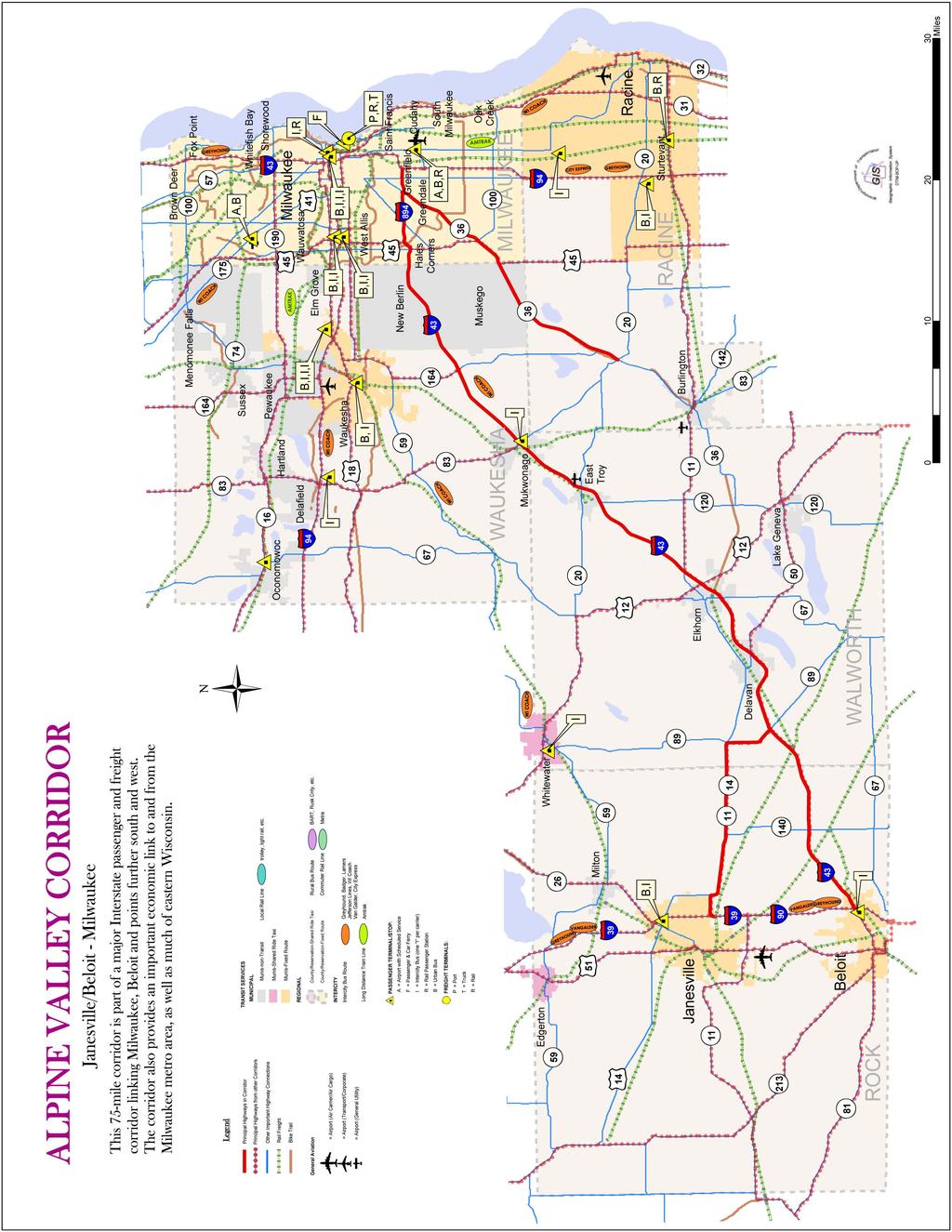
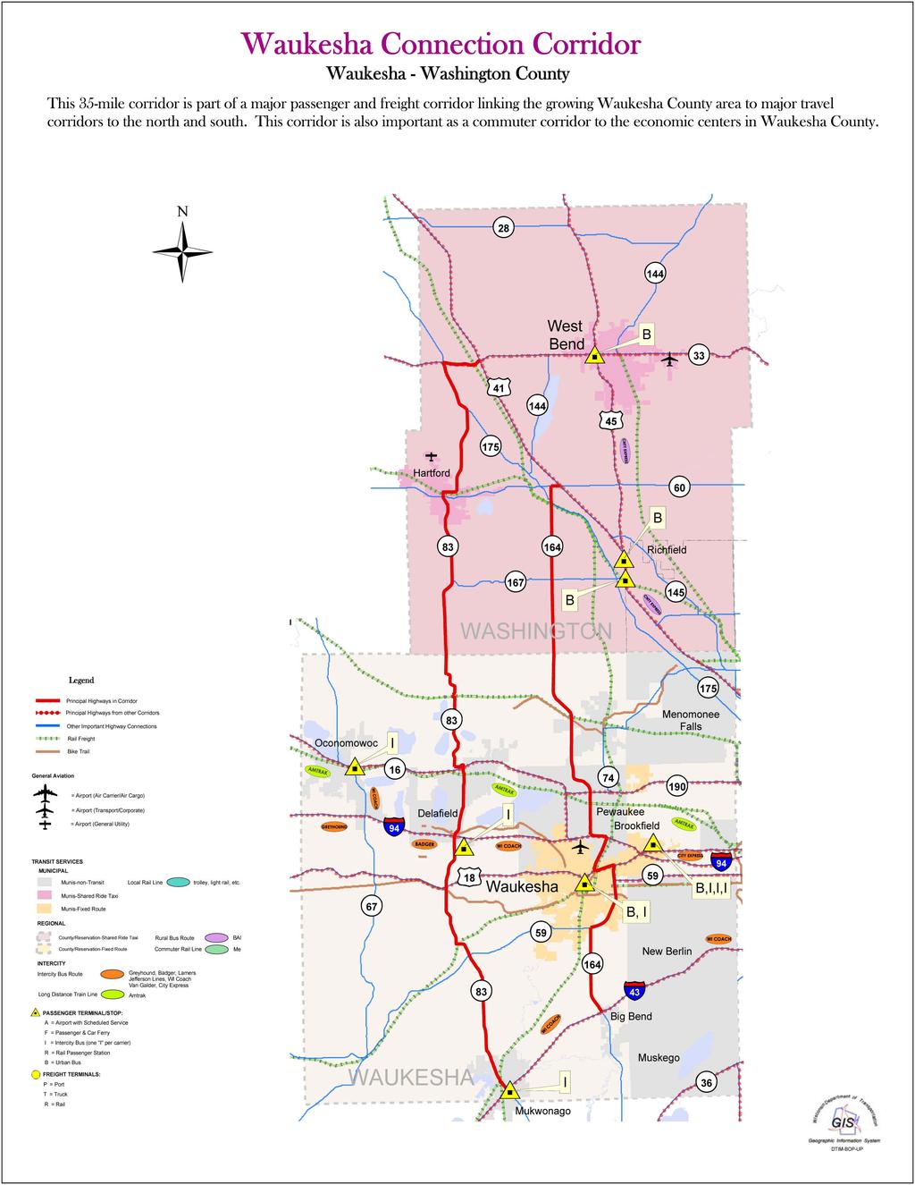
4 Town of Vernon 2026 Smart Growth Plan AIR TRANSPORTATION The Town of Vernon is served mainly by General Mitchell International Airport in Milwaukee. The Town is also served by the Waukesha County Airport and Lawrence J. Timmerman Airport in northern Milwaukee. WATER TRANSPORTATION The Town has no water transportation facilities. OTHER PLANS A Regional Transportation System Plan for Southeastern Wisconsin: 2035 In 2006, the Regional Planning Commission adopted a regional transportation system plan as a result of a major review and re-evaluation of the design year 2020 plan adopted by the Southeastern Wisconsin Regional Planning Commission (SEWRPC) in 1997, and its amendments and extensions to the design year 2025 adopted in The major recommendations involving the Town of Vernon include widening Big Bend Drive from two to four lanes between I-43 and Edgewood Avenue and reserving right-of-way to widen Big Bend Drive from two to four lanes between Forest Home Avenue and S. Denoon Road. Connections 2030 The Wisconsin Department of Transportation (WisDOT) is currently engaged in a policy-based, statewide long-range transportation plan for the year The plan, which is projected for a final release in the spring of 2006, focuses on designated multimodal corridors for each part of the state. The Town of Vernon is mainly affected by two corridors: Alpine Valley Corridor (Janesville/Beloit-Milwaukee) This corridor is an important passenger and freight route linking Milwaukee and the Beloit-Janesville area. The corridor also provides an important economic connection for the Milwaukee metro area. The principal highways in this 75-mile corridor are State Highway 11, U.S. Highway 14, Interstate Highway 43, and State Highway 36 north of Burlington. Waukesha Connection Corridor (Waukesha-Washington County) This corridor is part of a major freight and passenger transportation system linking Waukesha County to travel corridors to the north and south. The 35-mile corridor is also important for commuters between the economic centers in Waukesha County. The principal highways in this corridor are State Highway 83 and State Highway 164. Foth Infrastructure & Environment, LLC 5-4
5 5-5
6 5-6
Existing Transportation System 5-1
 5-1 The Jackson County transportation system is served by several modes of transportation including streets and highways, multi-modal, non-motorized, rail, and aviation. While the focus of the transportation
REVIEW AND EVALUATION OF REGIONAL LAND USE
 REVIEW AND EVALUATION OF REGIONAL LAND USE AND TRANSPORTATION SCENARIOS #220831 Environmental Justice Task Force October 7, 2014 VISION 2050 Process Development of Guiding Vision for Land Use and Transportation
TRANSPORTATION ELEMENT GOALS, OBJECTIVES, AND POLICIES
 TRANSPORTATION ELEMENT GOALS, OBJECTIVES, AND POLICIES GOAL 2 The City shall provide a safe, convenient, effective, and energy efficient multimodal transportation system which is coordinated with the Future
September 25th, 2018 $2000 fee pd CC
 2.7267 acres 2018I-00075 September 25th, 2018 $2000 fee pd CC Rezoning Review Criteria Analysis - Map Amendment Application Number: 2018I-00075 805 W. 38 th Avenue October 19, 2018 (amd.) September 17,
CHAPTER 7: Transportation, Mobility and Circulation
 AGLE AREA COMMUNITY Plan CHAPTER 7 CHAPTER 7: Transportation, Mobility and Circulation Transportation, Mobility and Circulation The purpose of the Transportation, Mobility and Circulation Chapter is to
CHAPTER 6 EXISTING PLANS AND ORDINANCES
 CHAPTER 6 EXISTING PLANS AND ORDINANCES This Comprehensive Plan is intended, in part, to review the land use and related plans adopted by the City of Kenosha, update those plans as necessary to comply
1.0 Circulation Element
 5/9/18 1.0 Circulation Element 1.1 Introduction As growth and development occur in Apache County, enhancements to its circulation system will be necessary. With time, more roads will be paved and air and
Brian Madigan, RLA, CPESC Director Land Planning & Design
 Brian Madigan, RLA, CPESC Director Land Planning & Design bmadigan@gymodpc.com Architecture, Engineering & Land Surveying, DPC 18969 US Route 11 Watertown, New York 13601 T: (315) 788-3900 F: (315) 788-0668
EXECUTIVE SUMMARY A COMPREHENSIVEC PLAN CITY : 2035 FOR THE OF KENOSHA: 2035 COMPREHENSIVE ADOPTED 19, 2010 ORDINANCE BY THE COMMON
 EXECUTIVE SUMMARY A COMPREHENSIVEC PLAN FOR THE : 2035 CITY OF KENOSHA: 2035 ~ COMPREHENSIVE PLAN ADOPTED BY THE COMMON COUNCIL: : APRILA 19, 2010 RDINANCE NO.. 28-10 ORDINANCE EXECUTIVE SUMMARY A COMPREHENSIVE
Transportation. Strategies for Action
 Transportation A major priority for the Overlake Neighborhood is to develop a multimodal transportation system. To achieve this system, a balance has to be found among travel, circulation and access needs;
STREETSCAPE MANUAL ONLINE TRAINING SESSION 1: Background
 TRAINING SESSION 1: The Urban Design Streetscape Manual is a reference tool developed to help implement City policy and guide the design, construction and maintenance of streetscape improvements in Toronto.
West Salem Comprehensive Plan
 West Salem Comprehensive Plan Village of West Salem, La Crosse County, WI DRAFT December 2007 Schreiber / Anderson Associates, Inc Village of West Salem Comprehensive Plan Table of Contents 1. Issues
CHAPTER 21: INTERGOVERNMENTAL COOPERATION
 CHAPTER 21: INTERGOVERNMENTAL COOPERATION Revisions approved by Council 11/15/16 via Ordinance #2579 INTRODUCTION In A Guide to Preparing the Intergovernmental Cooperation Element of a Local Comprehensive
1.0 INTRODUCTION 1.1 TH 14 WEST STUDY AREA Project Description Functional Classification Purpose of the Project
 1.0 INTRODUCTION 1.1 TH 14 WEST STUDY AREA 1.1.1 Project Description The Trunk Highway (TH) 14 West Corridor is a two-lane roadway approximately 22 miles in length. Located in Nicollet County, the corridor
Environmental: Urban land..51 acre wet (.30%); 1.01 acres/.59% within a 100 year floodplain; no other environmental indicators limit development.
; 1.01 acres/.59% within a 100 year floodplain; no other environmental indicators limit development.") A N DOV ER Downtown: Designated a State PDA Land Use: Downtown Andover (171.61 acres) is the Town s traditional central business district. It consists of offices, shops, restaurants, civic and institutional
A N DOV ER Downtown: Designated a State PDA Land Use: Downtown Andover (171.61 acres) is the Town s traditional central business district. It consists of offices, shops, restaurants, civic and institutional
Proposed Comprehensive Plan Strategies DRAFT for discussion June 28, 2017
 Proposed Comprehensive Plan Strategies DRAFT for discussion June 28, 2017 Land Use Rural Areas Refine the Farm and Forest area (FF) Update FF boundaries to account for existing lots less than five acres
Bypass #16 - Bend Parkway (new alignment for US 97) (MP )
 (MP )") Bypass #16 - Bend Parkway (new alignment for US 97) (MP 134.76-141.83) Description: The Parkway is on new alignment for US 97 through Bend. US 97 is a Statewide Highway on the National Highway System that
Bypass #16 - Bend Parkway (new alignment for US 97) (MP 134.76-141.83) Description: The Parkway is on new alignment for US 97 through Bend. US 97 is a Statewide Highway on the National Highway System that
South Davis County COMMUNITY SPOTLIGHT
 South Davis County COMMUNITY SPOTLIGHT Davis/SLC Community Connector Bus Rapid Transit line connecting SLC & Davis County RTP Phase 1 Project Generate 3,100 average weekday riders Relieve congestion on
Chapter 3: Land Use and Local Planning
 3.1 Chapter 3: Land Use and Local Planning 2040 3.2 Chapter 3: Land Use and Local Planning CONTENTS Introduction 3.3 Coordinating Thrive MSP 2040 and Transportation Policy Plan 3.6 Coordination of Regional
5.0 TRANSPORTATION ELEMENT
 INTRODUCTIONIntroduction 5.0 ELEMENT A community s transportation infrastructure supports the varied needs of its residents, local businesses, visitors, and through-traffic. This chapter summarizes the
Urban Development Areas Albemarle County
 1 Urban Development Areas Albemarle County UDA Needs Profile: All UDAs Albemarle County has two UDAs: the Pantops UDA located east of the Rivanna River and the City of Charlottesville, and Places 29 South,
PRELIMINARY REPORT. HIGHWAY 18 CORRIDOR NEIGHBORHOOD PLAN VILLAGE OF DOUSMAN November, 2014
 PRELIMINARY REPORT HIGHWAY 18 CORRIDOR NEIGHBORHOOD PLAN VILLAGE OF DOUSMAN November, 2014 This preliminary report presents the initial recommendations for land use within the Highway 18 corridor along
THE GARDEN CITY PLAN. City of St. Catharines Official Plan. City of St. Catharines
 THE GARDEN CITY PLAN City of St. Catharines Official Plan City of St. Catharines August 2010 APPROVAL INFORMATION This Official Plan of the City of St. Catharines Planning Area, known as the Garden City
Subregion 4 Central Avenue-Metro Blue Line Corridor Transit-Oriented Development (TOD) Implementation Project. Community Meeting April 27, 2011
 Implementation Project. Community Meeting April 27, 2011") Subregion 4 Central Avenue-Metro Blue Line Corridor Transit-Oriented Development (TOD) Implementation Project Community Meeting April 27, 2011 Overview Introduction to Subregion 4 TOD Implementation Program
Subregion 4 Central Avenue-Metro Blue Line Corridor Transit-Oriented Development (TOD) Implementation Project Community Meeting April 27, 2011 Overview Introduction to Subregion 4 TOD Implementation Program
Definitions. Average Daily Traffic Demand (ADT): The actual number or projected number of cars that pass a point in a 24-hour period.
: The actual number or projected number of cars that pass a point in a 24-hour period.") Definitions Access Management: A combination of physical techniques and transportation policies used to control the flow of traffic between roads and the surrounding lands. Alternative City Form Scenarios:
Definitions Access Management: A combination of physical techniques and transportation policies used to control the flow of traffic between roads and the surrounding lands. Alternative City Form Scenarios:
CHAPTER 20: NEIGHBORHOOD J
 CHAPTER 20: NEIGHBORHOOD J INTERSTATE 43 & RACINE QUARRIES Revisions approved by Council 11/15/16 via Ordinance #2579 PLANNING CONTEXT The Highway Interstate 43 & Racine Avenue interchange offers numerous
CHAPTER 7: VISION AND ACTION STATEMENTS. Noble 2025 Vision Statement
 CHAPTER 7: VISION AND ACTION STATEMENTS This chapter presents the vision, policy and action statements that transform the comprehensive planning study, an analysis of Noble s past, future trends and community
Johnson County I-69. Corridor Plan DRAFT DRAFT
 Johnson County I-69 Corridor Plan July 2018 JOHNSON COUNTY CORRIDOR PLAN This page intentionally left blank TABLE OF CONTENTS Chapter 1: Executive Summary... Chapter 2: Introduction... Chapter 3: Existing
1.0 VISION STATEMENT. December 6, PRINCIPLES
 Vision Statement Lincoln Regional Airport 1.0 VISION STATEMENT 1.1 City LOCATION of AND OVERVIEW The Easton Lincoln Place Land Use Master Plan identifies the principles, goals, policies, and standards
Corridors. Re-vitalize our Corridors and Gateways
 Corridors Re-vitalize our Corridors and Gateways Artist s rendering from the 287 Strategic Plan, 2015 Corridors are the major throughways of Loveland but they also provide important commercial, community
The transportation system in a community is an
 7 TRANSPORTATION The transportation system in a community is an important factor contributing to the quality of life of the residents. Without a sound transportation system to bring both goods and patrons
INCORPORATING COMPLETE STREETS INTO TRANSPORTATION MASTER PLANS. Brett Sears, M.Pl., MCIP, RPP
 INCORPORATING COMPLETE STREETS INTO TRANSPORTATION MASTER PLANS Brett Sears, M.Pl., MCIP, RPP Senior Project Planner Transportation Planning May 2013 PRESENTATION OUTLINE Why are Complete Streets Important?
Preliminary Assessment of Transportation Issues Related to Proposed Casino at Gateway South
 Preliminary Assessment of Transportation Issues Related to Proposed Casino at Gateway South DRAFT - 9/16/09 This memorandum summarizes the perspective of the City of Baltimore, Department of Transportation
Welcome. Walk Around. Talk to Us. Write Down Your Comments
 Welcome This is an information meeting introducing the applications for proposed redevelopment of the Yorkdale Shopping Centre site at 3401 Dufferin Street and 1 Yorkdale Road over the next 20+ years,
LAND USE DESIGNATIONS AND ZONING CLASSIFICATIONS
 LAND USE DESIGNATIONS AND ZONING CLASSIFICATIONS One of the most significant issues addressed within the community plan process is land use. How land is utilized within a community directly affects the
2. AGENCY COORDINATION AND PUBLIC INVOLVMENT
 2. AGENCY COORDINATION AND PUBLIC INVOLVMENT This chapter discusses the process carried out for conducting agency coordination and public involvement activities. TECHNICAL ADVISORY COMMITTEE A Technical
Town of Portola Valley General Plan. Nathhorst Triangle Area Plan
 Town of Portola Valley General Plan Amended December 10, 1997 Table of Contents Introduction... 1 Planning Area... 1 Objectives... 2 Principles... 2 Standards... 4 Description... 4 Community Commercial...
Place and Opportunity: An Equity Assessment of the Twin Cities Region (www.metrocouncil.org/
 1 Purpose and Need This chapter gives an overview of the proposed METRO Blue Line Light Rail Transit (BLRT) Extension project, including its location and setting within the local communities and the region,
DOWNTOWN JACKSONVILLE MASTER PLAN S T R E E T H I E R A R C H Y
 DOWNTOWN JACKSONVILLE MASTER PLAN S T R E E T H I E R A R C H Y Gateway Intra-District Business Inter-District 44 CELEBRATING THE RIVER: A PLAN FOR DOWNTOWN JACKSONVILLE The Transportation Network This
MODEL ACCESS MANAGEMENT PLAN MINNESOTA TRUNK HIGHWAY 7 COMPREHENSIVE PLAN AMENDMENT (HUTCHINSON SEGMENT)
") MODEL ACCESS MANAGEMENT PLAN MINNESOTA TRUNK HIGHWAY 7 (HUTCHINSON SEGMENT) COMPREHENSIVE PLAN AMENDMENT INTRODUCTION. The purpose of this plan is to provide consistent access management in the Trunk
MODEL ACCESS MANAGEMENT PLAN MINNESOTA TRUNK HIGHWAY 7 (HUTCHINSON SEGMENT) COMPREHENSIVE PLAN AMENDMENT INTRODUCTION. The purpose of this plan is to provide consistent access management in the Trunk
Table IX-1 LAND USES IN WASHINGTON COUNTY: 2006
 #128550 v1 - WASH CO CP TBL I-1 2006 LU NMA/RLR 12/21/07 Table I-1 LAND USES IN WASHINGTON COUNTY: 2006 Note: This table, and the accompanying map, is more general than the land use inventory conducted
Appendix E. Development Concepts
 Appendix E The following analyses examine alternative land use concepts by listing the different advantages and disadvantages of each. The alternatives are graphically presented on the Development Concept
RESOLUTION NO R
 e e RESOLUTION NO R04 0054 BE IT RESOLVED by the Mayor and City Council ofthe City ofpapillion that The Papillion Comprehensive Plan is hereby amended to incorporate the Option A Future Land Use Map Transportation
OFFICE CONSOLIDATION SECONDARY PLAN AREA 22 THE BRAMALEA SOUTH INDUSTRIAL SECONDARY PLAN
 OFFICE CONSOLIDATION SECONDARY PLAN AREA 22 THE BRAMALEA SOUTH INDUSTRIAL SECONDARY PLAN November 2010 EXPLANATORY NOTES (Secondary Plan Area 22) General (pertaining to all secondary plan office consolidations)
City of Royalton Comprehensive Land Use Plan 2005 to Revision February 8, 2011
 City of Royalton Comprehensive Land Use Plan 2005 to 2015 2011 Revision February 8, 2011 PART ONE: INTRODUCTION TO THE COMPREHENSIVE PLAN 1.0 Purpose and Introduction The Comprehensive Land Use Plan provides
COLVER ROAD INDUSTRIAL CONCEPT PLAN
 COLVER ROAD INDUSTRIAL CONCEPT PLAN A CONCEPTUAL LAND USE AND TRANSPORTATION PLAN FOR TA-4 AN URBAN RESERVE AREA OF THE CITY TALENT City of Talent Adopted by City Council Resolution No., June, 2015 PART
12/9/2013. HOLLYWOOD/PINES CORRIDOR PROJECT AMPO 2013 Annual Conference October 24, Our Perspective. Broward.
 HOLLYWOOD/PINES CORRIDOR PROJECT AMPO 2013 Annual Conference October 24, 2013 Our Perspective Broward Fort Lauderdale 1 Broward Metropolitan Planning Organization Fort Lauderdale Fort Lauderdale Skyline
The Village of Shirlington
 The Village of Shirlington Suburban Smart Growth Without Rail Transit July 2018 Agenda History (1940 to present) Attributes and Outcomes Lessons Learned Setting the Stage Arlington County Arlington is
I. INTRODUCTION. Project Background and Study Area
 I. INTRODUCTION Project Background and Study Area Freedom Parkway is a key east-west corridor connecting I-25 on the west to the Town of Kersey on the east, running approximately one to two miles south
Staff Report and Recommendation
 Community Planning and Development Planning Services 201 W. Colfax Ave., Dept. 205 Denver, CO 80202 p: 720.865.2915 f: 720.865.3052 www.denvergov.org/cpd TO: City Council Neighborhoods and Planning Committee
Harlem Avenue Corridor Plan: Corridor Planning Across Municipal Boundaries
 Harlem Avenue Corridor Plan: Corridor Planning Across Municipal Boundaries Heather Tabbert, Manager, Local Planning and Programs Division Regional Transportation Authority (RTA) Jen McNeil Dhadwal, Principal
1.0 Introduction. Purpose and Basis for Updating the TMP. Introduction 1
 1.0 Introduction The Town of Castle Rock is situated between the metropolitan areas of Denver and Colorado Springs, amidst a unique terrain of rolling hills, mesas, ravines, and waterways. Like many Front
A Plan for the Heart of the Region: Tukwila, WA
 : Tukwila, WA 1 The Plan orchestrates the Restructuring of a 1,000-acre Regional Shopping Area into a Social and Symbolic for the Region. REGIONAL CONTEXT Downtown Seattle (Metropolitan ) 20 miles Bellevue
Section 1. Executive Summary
 Executive Summary (This page left blank intentionally) Executive Summary Background Economic growth in southern Leavenworth County over the past decade has been strong. As both the number of business and
Comprehensive Development Guide
 INDUSTRIAL ELEMENT Comprehensive Development Guide 1 Industrial Element 7.1 Hardin County Industrial Overview BG PKWY Fort Knox Industrial Corridor Comprised of 11 parcels totaling 720 acres of land 68
1. PLANNING CONCEPTS. Central Petaluma Specific Plan Chapter 1. Planning Concepts Page 7
 Page 7 1. PLANNING CONCEPTS Overview of Planning Concepts The plan for Central Petaluma envisions a reinvigorated central district that accommodates a greater diversity and intensity of activities, including
Chapter 3 Land Use and Local Planning
 Chapter 3 Land Use and Local Planning Introduction Transportation and land use play off each other. Transportation infrastructure gives value to land and influences its use. Land use, in turn, creates
Strategic Growth Area #1 Northampton Boulevard Corridor Area
 Strategic Growth Area #1 Northampton Boulevard Corridor Area Description Strategic Growth Area #1 has established itself as a major employment center in Southside Hampton Roads. Opportunities exist to
Introduction. Community Outreach Approach. Sacramento Valley Station Master Plan. Online Questionnaire Summary of Feedback.
 Introduction Located in the northwest sector of downtown Sacramento, the Sacramento Valley Station (SVS) is the primary rail station in northern California and the seventh busiest station in the country.
Description of Preferred Alternative
 Chapter 2 Description of Preferred Alternative 2.1 Introduction This chapter of the programmatic Sammamish Town Center Sub-area Plan Final EIS provides a more detailed description of the Preferred Alternative
Gold Line Bus Rapid Transit Transit Oriented Development (BRTOD) Helmo Station Area Plan
 Helmo Station Area Plan") Appendix F Gold Line Bus Rapid Transit Transit Oriented Development (BRTOD) Helmo Station Area Plan Introduction and Purpose of the Plan The Gold Line Bus Rapid Transit facility is an eleven-mile dedicated
Appendix F Gold Line Bus Rapid Transit Transit Oriented Development (BRTOD) Helmo Station Area Plan Introduction and Purpose of the Plan The Gold Line Bus Rapid Transit facility is an eleven-mile dedicated
12 AMENDMENT NO. 149, TOWN OF MARKHAM HIGHWAY 404 NORTH SECONDARY PLAN
 12 AMENDMENT NO. 149, TOWN OF MARKHAM HIGHWAY 404 NORTH SECONDARY PLAN The Planning and Economic Development Committee recommends the adoption of the recommendation contained in the following report August
PROTOTYPE DESIGN/INTRODUCTION
 PART III: PROTOTYPE DESIGN These concepts and guidelines described earlier were used to develop a prototype design for an emerging suburban area located west of the City of Milwaukee. This was done to
DRAFT. Urban Development Areas Fairfax County. UDA Needs Profile: Tysons Corner 13% Location Characteristics. Socio-Economic Characteristics
 14 Urban Development Areas Fairfax County UDA Needs Profile: Tysons Corner Tysons Corner is located in Fairfax County, surrounded by the town of McLean to the east and Vienna on the west along I-495, the
TABLE OF CONTENTS INTRODUCTION PLAN CONCEPT... 3
 TABLE OF CONTENTS BY-LAW NO. Z-1 INTRODUCTION... 1 1.0 PLAN CONCEPT... 3 1.1 Mission... 3 1.2 A Future Vision for Fredericton... 3 1.3 Growth Strategy Goals... 5 National Context... 5 Provincial Context...
CHAPTER 1. Ms. Guajardo s Class - Central Elementary CH 1 1
 INTRODUCTION CHAPTER 1 Ms. Guajardo s Class - Central Elementary CH 1 1 1.1 SETTING South Centre City is a linear corridor south of Downtown Escondido paralleling Centre City Parkway and South Escondido
Chapter 4. Linking Land Use with Transportation. Chapter 4
 Chapter 4 Linking Land Use with Transportation Chapter 4 59 Chapter 4 Linking Land Use with Transportation Community Design and Transportation Program Introduction Since the 1950s, the predominant development
Route 66 Business Corridor
 Route 66 Business Corridor DOWNTOWN BUSINESS AND CULTURAL DISTRICT SPECIFIC PLAN Draft April 2016 Acknowledgments Text Acknowledgments here etc... LIST NAME List List List Table of Contents 1. Introduction...
Land Use and Transportation Plan
 5 Land Use & Transportation Plan Figure 5.1 Construction at I 10 on ramp Land Use and Transportation Plan The Land Use and Transportation Plan represents the preferred land use, physical form, and circulation
Northwest Rail Corridor and US 36 BRT Development Oriented Transit Analysis 4.4 STATION AREA FINDINGS
 4.4 STATION AREA FINDINGS Each station is different, and each one requires a separate set of recommendations based on the vision for the site. This section outlines an initial TOD strategy and recommendations
Metro Orange Line Extension Four Years Early and $61 Million Under Budget
 White Paper: Metro Orange Line Extension Four Years Early and $61 Million Under Budget July 2013 Innovation for better mobility Metro Orange Line Extension Iteris, Inc. was the prime consultant leading
2.0 PURPOSE AND NEED. 2.1 Purpose. 2.2 Need Traffic Congestion in and around Downtown Derry
 2.0 PURPOSE AND NEED Taking into consideration agency and public input, the purpose and need for the Project was identified early in Project planning. As noted in Appendix A, for purposes of meeting the
POCKET COMMUNITY PLAN
 POCKET COMMUNITY PLAN Part Three : COMMUNITY PLAN AREAS AND SPECIAL STUDY AREAS CONTENTS Community Location... 3-P-3 Community Vision... 3-P-4 Community Profile... 3-P-4 Community Issues... 3-P-6 Land
Urban Development Areas Bedford County
 5 Urban Development Areas Bedford County UDA Needs Profile: All UDAs Bedford County has designated two UDAs: areas just outside the Bedford City Limits (generally to the south and east of the city) and
ITEM #8. Regional Smart Growth Program. Regional Smart Growth Program. Presentation Overview. Coast Highway Vision and Stategic Plan.
 Regional Smart Growth Program Economic Development Commission What is Smart Growth? Adopted as part of the Regional Comprehensive Plan (RCP) RCP provides vision for region based on Smart Growth and sustainability
URBAN DESIGN BRIEF URBAN DESIGN BRIEF 721 FRANKLIN BLVD, CAMBRIDGE August 2018
 URBAN DESIGN BRIEF URBAN DESIGN BRIEF 721 FRANKLIN BLVD, CAMBRIDGE August 2018 DESIGN BRIEF CONTENTS PART A 1.0 INTRODUCTION 2.0 DESCRIPTION & ANALYSIS OF SITE CONTEXT 3.0 DESIGN CONSTRAINTS AND OPPORTUNITIES
Introduction to the Project
 Chapter 1 Introduction to the Project 1.1 Project Introduction The New Hampshire Department of Transportation (NHDOT) and the Federal Highway Administration (FHWA) have prepared this Environmental Assessment/Draft
NOTE: PLEASE REFER TO MISSISSAUGA PLAN FOR ADDITIONAL CITY-WIDE POLICIES WHICH APPLY TO THIS DISTRICT.
 NOTE: THE POLICIES IN THIS DOCUMENT ARE SPECIFIC TO THE FAIRVIEW PLANNING DISTRICT OF, AND MUST BE READ IN CONJUNCTION WITH ALL THE POLICIES OF PLEASE REFER TO FOR ADDITIONAL CITY-WIDE POLICIES WHICH APPLY
Three Decades of Smart Growth: Arlington s Urban Village
 Three Decades of Smart Growth: Arlington s Urban Village An Overview Christopher Zimmerman Arlington County Board January 26, 2006 Arlington, Virginia 3 1 Arlington Today Population ~200,000 Jobs >200,000
Land Use and Local Planning
 Chapter 3 Land Use and Local Planning Introduction Transportation and land use play off each other. Transportation infrastructure gives value to land and influences its use. Land use, in turn, creates
EXECUTIVE SUMMARY. Introduction
 EXECUTIVE SUMMARY Introduction State Route 68 is a designated scenic route that connects the world-renowned Monterey Peninsula to US Highway 101 and the Salinas Valley. SR 68 is a key route for bicycle,
Tyvola & Archdale Transit Station Area Plan. June 5, 2008
 Tyvola & Archdale Transit Station Area Plan Second Public Meeting June 5, 2008 Presentation Outline 1. Purpose and Process 2. Station Area Overview 3. Plan Recommendations 4. Comments Received and Proposed
Town Center (part of the Comprehensive Plan)
") Town Center (part of the Comprehensive Plan) Mercer Island Town Center Looking North (2014) In 1994, a year-long process culminated in a set of design guidelines and code requirements for the Town Center
Town Center (part of the Comprehensive Plan) Mercer Island Town Center Looking North (2014) In 1994, a year-long process culminated in a set of design guidelines and code requirements for the Town Center
TRANSPORTATION ELEMENT
 TRANSPORTATION ELEMENT GOAL I: To create and maintain a safe, efficient and aesthetic transportation system that encourages multi-modal transportation and promotes the mobility strategies of the Ocala
Chapter 1.0 Introduction
 Chapter 1.0 Introduction 1.1 Background The North Metro commuter rail line is part of the RTD FasTracks regional transit system expansion program to build more than 100 miles of rail transit throughout
Glenborough at Easton Land Use Master Plan
 Vision Statement Sunrise Blvd. Hazel Ave. Prairie City Rd. Gencorp Property Lincoln Regional Airport 1.0 VISION STATEMENT The identifies City of the principles, goals, policies, and standards Lincoln that
BROOKHILL NEIGHBORHOOD MODEL ZONING MAP AMENDMENT PREFACE TO APPLICATION
 BROOKHILL NEIGHBORHOOD MODEL ZONING MAP AMENDMENT PREFACE TO APPLICATION June 15, 2015 Revised: August 1, 2016 I. VISION Brookhill is a proposed community based upon the principles of Albemarle County
Planning Area & Context. Planning Goals. 1. Improve circulation and traffic. 2. Increase mutual trust and benefits
 Planning Area & Context Planning Goals 1. Improve circulation and traffic 2. Increase mutual trust and benefits 3. Design integrated streets/ buildings 4. Provide housing and mixed-uses 5. Create and enhance
COUNCIL COMMUNICATION
 Meeting Date: June 13, 2017 COUNCIL COMMUNICATION Agenda Item: Agenda Location: Consent Calendar Work Plan # 194,195, 196 Legal Review: 1 st Reading 2 nd Reading Subject: A resolution approving Thornton
6. Consistency with Local Plans
 6. Consistency with Local Plans 6.1. Chapter Overview 6.1.1. Introduction This section presents the goals, objectives and policies of municipal, county and state planning entities, as well as known development/redevelopment
Planning Commission Report
 Planning Commission Report To: From: Subject: Planning Commission Meeting: January 6, 2016 Agenda Item: 8-B Planning Commission David Martin, Planning & Community Development Director Introduction to the
[PLANNING RATIONALE] For Site Plan Control and Lifting of Holding Zone By-Law 101 Champagne Avenue. May 23, 2014
![[PLANNING RATIONALE] For Site Plan Control and Lifting of Holding Zone By-Law 101 Champagne Avenue. May 23, 2014](/thumbs/75/71599615.jpg "[PLANNING RATIONALE] For Site Plan Control and Lifting of Holding Zone By-Law 101 Champagne Avenue. May 23, 2014") [PLANNING RATIONALE] For Site Plan Control and Lifting of Holding Zone By-Law 101 Champagne Avenue May 23, 2014 Contents 1.0 Introduction... 2 2.0 Site Context... 2 2.1 Adjacent Uses... 2 Figure 1: Site
[PLANNING RATIONALE] For Site Plan Control and Lifting of Holding Zone By-Law 101 Champagne Avenue May 23, 2014 Contents 1.0 Introduction... 2 2.0 Site Context... 2 2.1 Adjacent Uses... 2 Figure 1: Site
1.0 PLANNING MARKHAM S FUTURE CONTENTS
 1-1 Planning Markham s Future 1.0 PLANNING MARKHAM S FUTURE CONTENTS 1.1 THE PURPOSE OF THE OFFICIAL PLAN 1.2 THE MARKHAM CONTEXT 1.3 THE REGULATORY CONTEXT 1.3.1 Province of Ontario 1.3.2 York Region
Central and East Neighbourhoods - Hermitage Outline Plan
 Central and East Neighbourhoods - Hermitage Outline Plan Office Consolidation September 2013 Prepared by: Planning and Policy Services Branch Planning and Development Department City of Edmonton The Central
PURPOSE AND NEED FOR THE VROOMAN ROAD BRIDGE and ROADWAY IMPROVEMENT PROJECT
 PURPOSE AND NEED FOR THE VROOMAN ROAD BRIDGE and ROADWAY IMPROVEMENT PROJECT PERRY AND LEROY TOWNSHIPS, LAKE COUNTY, OHIO (PID 5669/PID 85131) PREPARED BY: MICHAEL BAKER JR., INC. 1228 EUCLID AVENUE SUITE
DEVELOPMENT FRAMEWORK POST 2030 LAND USE PLAN INTRODUCTION
 INTRODUCTION Oak Grove s Comprehensive Plan identifies a future Metropolitan Urban Service Area (MUSA). The Metropolitan Council does not anticipate extending utilities to this area prior to 2030. The
3. ELEMENTS OF THE METRO VISION 2035 PLAN
 3. ELEMENTS OF THE METRO VISION 2035 PLAN What is Metro Vision and why does it matter? For more than 50 years, DRCOG has championed a regional perspective on key issues facing the metropolitan area and
Coast Highway Oceanside, California
 Coast Highway Oceanside, California Coast Highway Plan Zones What We ve Heard - Walkable/Bikeable Community (Senior and Child Friendly) -Wider Sidewalks -Street Trees -Traffic Calming -Bike Lanes -Paseos
MEMORANDUM AGENDA ITEM #IV.C
 MEMORANDUM AGENDA ITEM #IV.C DATE: NOVEMBER 27, 2017 TO: FROM: COUNCIL MEMBERS STAFF SUBJECT: LOCAL GOVERNMENT COMPREHENSIVE PLAN PROPOSED AND ADOPTED AMENDMENT CONSENT AGENDA Pursuant to Section 163.3184,
Planning & Zoning Board Meeting. DRAFT Comprehensive Transportation Plan Update, February 23, 2018 version
 Planning & Zoning Board Meeting DRAFT Comprehensive Transportation Plan Update, February 23, 2018 version May 10, 2018 Overview Overview of Agency Comments Overview of proposed modifications to the Draft