Environmental Impact Statement
|
|
|
- Philomena Davis
- 5 years ago
- Views:
Transcription
1 for South of Embley Project Section 12 Visual Amenity
2
3 12 VISUAL AMENITY This section describes the current visual amenity of the Project area, identification of visual receptors, and the assessment methodology and evaluation of Project visual impacts. This assessment considers the visual impacts within the Project footprint and surrounding public areas that are likely to provide a view of the proposed Project components Evaluation Methodology The visual evaluation methodology is based on the assumption that the visual quality of the landscape increases as: relief and topographic ruggedness increases; vegetation patterns become more diverse; the proportion of natural and agricultural landscapes increases and the proportion of built (unnatural) landscapes decreases; and the presence of water forms increases. Visual impacts are predominantly subjective and strongly related to the sensitivity of the viewing source. Potentially sensitive locations can include: residences (especially those within 1km); major and secondary roads; recreational areas and tourist destinations; and heritage sites. The visual impact assessment for the Project area involved the following components: targeted visual site appraisal conducted in August Other visual assessments and photography were completed during the course of environmental field work, which included both wet and dry season inspections (between October 2007 and May 2009); 3D modelling of the proposed port; and an assessment of the potential impact of the proposed infrastructure on the existing landscape character Existing Visual Characteristics The Project area is located south of Weipa and consists of terrestrial, freshwater and marine environments. The Project area is situated in a remote location and is not easily accessible from surrounding communities. Current land access to the Project area is restricted to dirt tracks (via Beagle Camp Access Road), which are accessible only during the dry season. The Project area can also be reached by boat. There are no buildings or infrastructure present within the footprint of the area to be disturbed by mining and related infrastructure, the proposed port area or the Hey River barge/ferry terminal area. The proposed Humbug barge terminal is adjacent to the existing Humbug Wharf and the proposed Hornibrook ferry terminal is adjacent to the existing Lorim Point East Wharf. The Project area is predominantly a homogenous relatively flat bauxite plateau landform covered by 25 to 35m high Darwin Stringybark woodlands (refer Plate 12-1). The Project area is mostly undisturbed apart from vehicle tracks and lines cleared for exploration drilling. Section 12 Visual Amenity Page 12-1
. Norman Creek and the Ward River flow into large mangrove-lined estuaries.")

4 Plate 12-1 Exploration Drilling Track through Darwin Stringybark Woodland The main freshwater watercourses within the Project area include the Ward River, Norman Creek and Winda-Winda Creek. These watercourses are relatively undisturbed (refer Plate 12-2). Norman Creek and the Ward River flow into large mangrove-lined estuaries. The Embley and Hey Rivers border the northern portion of the mine lease area (ML 7024) and separate it from Weipa. The Embley River's estuary is up to 3km wide and includes a built environment view of wharf structures and buildings in the Port of Weipa, while the Hey River is relatively undisturbed along its length. The visual contrast within the largely uniform landscape of the Project area occurs where the bauxite plateau meets streams, estuaries or the coast. Section 12 Visual Amenity Page 12-2

5 Plate 12-2 Ward River The western portion of the Project area (excluding the proposed port infrastructure outside ML 7024) is bound by the Gulf of Carpentaria. Bauxite cliffs from 7 to 20m high occur along various parts of the coastline, most notably between Boyd Point and Thud Point. The red bauxite overlaying a band of white kaolin clays forms an aesthetically prominent landscape (Abrahams et al. 1995; Plate 12-3 and Plate 12-4). Section 12 Visual Amenity Page 12-3


6 Plate 12-3 Bauxite Cliffs between Pera Head and Boyd Point Plate 12-4 Bauxite Cliff Section 12 Visual Amenity Page 12-4
7 12.3 Visual Receptors There are no permanent residences in the Project area and the nearest communities are located away from the main Project components (refer Figure 12-1). The nearest residential areas are in Weipa and Napranum, located 40km north of the proposed port, and Aurukun, located 40km south of the proposed port. The closest mining areas are 4km from Napranum and 15km from Aurukun. Cattle grazing is the predominant agricultural land use in the wider Weipa region. However, the Project area is not grazed and no rural homesteads are located near the Project area. The closest cattle stations to the Project area are: "Watson River", located approximately 50km south-east; "York Downs" (previously called "Sudley"), located approximately 50km north-east; and "Merluna", located approximately 70km east. The primary viewpoint of the Project is from coastal and estuarine waters. The Gulf of Carpentaria waters adjoining the Project area are used by professional, recreational and tourguided fishing operations. There are five estuaries in the vicinity of the Project area, only one of which occurs entirely within it (Norman Creek estuary). The others only partially occur within the Project area but have catchments that drain it (Ward River, TriluckRoberts Creek, Leithen Creek and the EmbleyHey River system). Estuaries within the Project area are utilised by recreational and tour guided fishing groups on an intermittent basis. The Embley River is used by commercial and recreational vessels utilising the Port of Weipa. Traditional Owners regularly visit outstations in the Project area, including Amban (False Pera Head), Waterfall (near Ina Creek), and Six Ti-Tree (located a short distance south of Ina Creek) during the dry season to go camping, fishing and undertake other activities. The major Project components are not visible from these locations. However, they may be visible while travelling en route to these areas. Access to these locations is discussed in Section There are no gazetted public roads that traverse the Project area south of the Embley River and hence no viewpoints accessible from public roads. However, the general public do use various tracks in the Project area. Members of the general public wishing to access the lands covered by the Project area require a permit from the Aurukun Shire Council (refer Section ). Section 12 Visual Amenity Page 12-5


8 I I RTA Mining Lease boundary Township Road/track Tailings storage facility Mining Years 1-13 Fig. 12-1: Project Components and Visual Receptors Mining Years km thh. Datum/Projection: GDA94/MGA Zone 54 Date: 01/04/2011

9 12.4 Potential Impacts and Mitigation Measures The main visual elements of the Project and potential impacts on receptors are discussed below in terms of day and night Port The proposed port would be constructed between Boyd Point and Pera Head and include an approach jetty, wharf (four berths) and two ship loaders (at full capacity). The approach jetty would be approximately 568m long and the wharf, at maximum capacity, would be approximately 696m long. The proposed port would consist of an "I" berth aligned perpendicular to the shoreline (refer Figure 12-2). A 3D simulation for Stage 1 of the proposed port facilities, which includes two berths and one ship loader, is presented in Figure Total height of the wharf and jetty would be approximately 17m above lowest astronomical tide (LAT) and the top of the ship loaders would be approximately 40m above LAT. The height of the proposed port facilities would be comparable with the height of the Darwin Stringybark woodlands on top of the bauxite cliffs. Where possible, the approach jetty, wharf and ship loaders would be painted in a colour that minimises visual impacts, while adhering to marine safety standards. The proposed port infrastructure would be directly visible from vessels using Gulf of Carpentaria waters in the vicinity of Boyd Point and Pera Head, although the visual impacts are anticipated to be low, owing to the height of the natural cliffs and vegetation and the transitory nature of visits to the area. Lighting would be required at the proposed port for night operations. Due to the remote location of the site and lack of other lighting sources, lights on the proposed port would be visually prominent and are expected to create a "glow" in the night sky. RTA would implement a lighting plan at the port to mitigate the potential effects of altered above water, night-time light regime on sea turtle hatchlings (refer Section ). RTA would work with the Western Cape Communities Coordinating Committee and Department of Environment and Resource Management (DERM) through an adaptive approach to minimise the impacts of changes to the light regime during both the construction and operation phases of the proposed port on marine turtles, while still allowing a safe working environment. The following factors would be considered: ensuring lighting is minimised overall to that which is essential for safe and efficient operation of the facility; reducing lighting when there are no ships at berth or being piloted in the area; shielding and/or recessing lights to minimise light spill; installing long wavelength lights; and any other lighting options that further reduce impacts to marine turtles while allowing for the safe and efficient operation of the port facility. RTA propose an adaptive approach to work with the Traditional Owners and DERM to minimise the impacts of changes to the light regime during both the construction and operation phases of the proposed port on marine turtles, while still allowing a safe working environment. Nocturnal fauna in the immediate vicinity may be affected by lighting, although any impacts are expected to be localised Mine Infrastructure Areas The bauxite product stockpiles would be located a few hundred metres east of the proposed port site (refer Figure 12-2), behind a natural vegetation buffer of 25m to 35m high Darwin Stringybark woodlands. The stockpiles would include two stackers and two reclaimers (at maximum capacity) to handle the product bauxite. The maximum height of the stockpiles and stackers/reclaimers would be approximately 30m. The stockpiles and facilities would not Section 12 Visual Amenity Page 12-7

10 adversely affect the skyline as the height is comparable with the height of the Darwin Stringybark woodlands. The Boyd beneficiation plant would be situated approximately 1km east of the proposed port site, behind a natural vegetation buffer of Darwin Stringybark woodlands and behind the product stockpiles, and thus would not be visible from vessels using the Gulf of Carpentaria. The plant would be approximately 20m high. A tailings storage facility would be constructed adjacent to the beneficiation plant and at final capacity would be approximately 22m high. The infrastructure area would also include a power station and general infrastructure buildings (e.g. warehouse, workshops; refer Section 2). Any visual impacts from the stockpile and plant areas are considered to be low due the setback distance from the coastline and the retention of the vegetation buffer. Lighting would be required at the stockpiles and plant areas for construction and operations. Directional lighting located on the stackers and reclaimers is proposed for these areas in preference to permanent tower lighting to minimise light spill. Lighting at the Boyd infrastructure area is expected to create a "glow" in the night sky. Nocturnal fauna in the immediate vicinity may be affected by lighting, although any impacts are expected to be localised and of a minor nature. The potential impacts and management of lighting on marine turtles is discussed further in Section and other fauna in Section The Norman Creek beneficiation plant would be located approximately 15km south-east of the Boyd beneficiation plant and away from viewpoints such as the coastline or the Beagle Camp Access Road. The facilities would be similar to that of the Boyd beneficiation plant. Some lighting would be present on the beneficiation plant and mine industrial area buildings to enable night-time operations. Given the distance from the coastline and natural vegetation buffer, light glow from this facility is not anticipated to add appreciably to that from the proposed port Mining Mining would involve clearing vegetation and extraction of ore from shallow pits (refer Section 2.4). Mining involves removing around one metre of soil and overburden above the bauxite and then excavating the bauxite (which has an average thickness of 3.4m). Generally the subsoil and overburden stripped from a new mining area would be taken directly to an existing mined-out area that is awaiting rehabilitation. In circumstances when operational requirements prevent stripped material being directly re-spread, such as at commencement of operations, it would be temporarily stockpiled. The final landform would not have any out-of-pit dumps of excavated wastes or soil. The final landform would be at a lower elevation than the original landform due to the removal of the bauxite, but the overall slope of the landform would be similar. Vegetation would be retained within environmental buffers along the coastline and beside waterways. Mining would be excluded within the buffer areas (refer Section 7.9.2). There are no visual receptors within the mining areas. Given the minimal topographic changes associated with mining, the retention of vegetation buffers, the revegetation with local native species (refer Section ) and the lack of visual receptors, visual impacts are considered negligible. Lights from mining equipment are likely to have only a negligible impact, if any, on nocturnal fauna. Section 12 Visual Amenity Page 12-8


11 cron LU 0 Port Sediment Pond Mine Industrial Area ire P1/4GG' Truck Dump Station Stockpile (30Mt Production Stockpile (15Mt Production Sediment Pond 140 ML Process Water Dam Infrastructure Corridor to Norman Creek Plant and Dam C Future Sourthern Stockpile Tailings Storage Facility Aurukun Project Conveyor I 0 1km Fig. 12-2: Boyd Infrastructure Area and Port Datum/Projection: GDA94/MGA Zone 54 Date: 16/07/2010


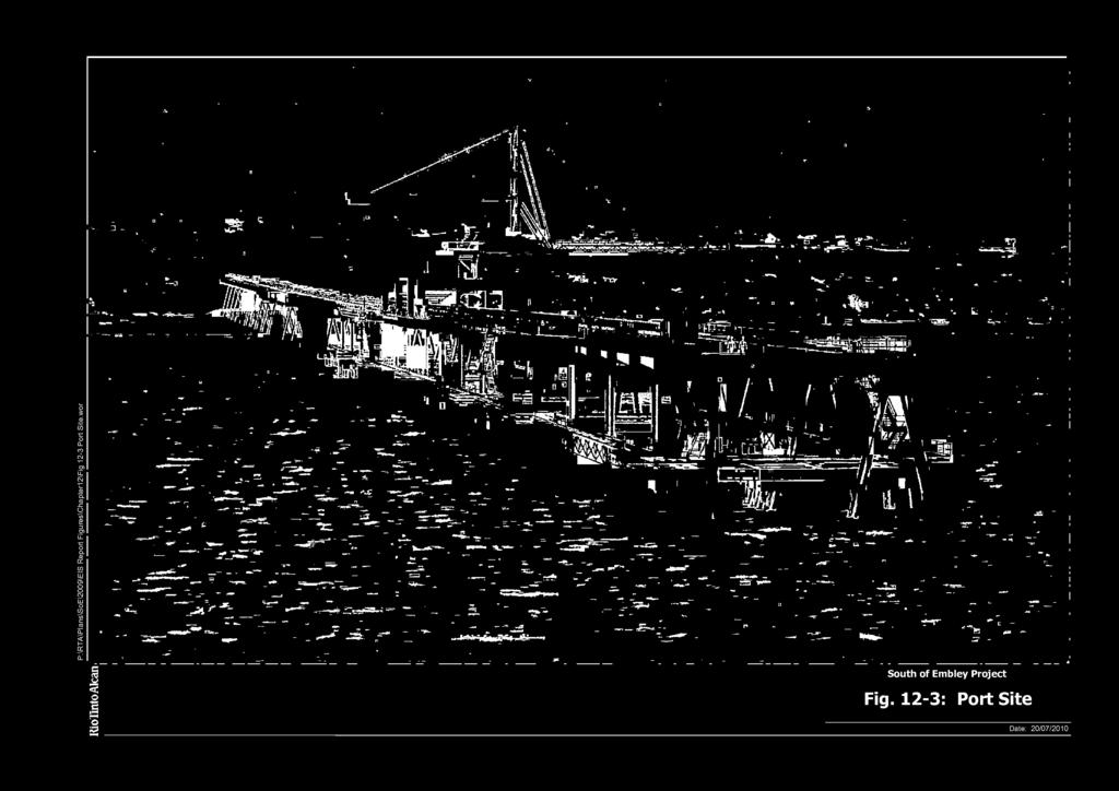
12 1...±ra Fig. 12-3: Port Site Date: 20/07/2010
.")
. The barge/ferry terminals involve minor developments on the shoreline of the Embley and Hey Rivers.")
13 Barge and Ferry Terminals The proposed Humbug barge terminal and the Hornibrook ferry terminal would be located on the northern bank of the Embley River, adjacent to the existing Humbug and Lorim Point East Wharves respectively (refer Plate 12-5 and Plate 12-6). The Hey River barge/ferry terminal would be sited on the western bank of the Hey River (refer Plate 12-7) approximately 6km south of Napranum. The Hey River Terminal would not be visible from Napranum (refer Plate 12-8). The barge/ferry terminals involve minor developments on the shoreline of the Embley and Hey Rivers. The terminals would include barge landings and ferry pontoons, small car parks and covered walkways all below the skyline of the natural vegetation (refer Section 2.7.2). Lighting would also be required at the terminals, although this would be minimal and designed to minimise nuisance lighting. The Humbug and Hornibrook terminals would be situated within existing industrial areas and are not expected to affect the visual aesthetics of the area. The Hey River Terminal would be located within an undeveloped section of the Hey River. It is not directly visible from Napranum (refer Plate 12-8); however, a low glow from lighting at the terminal may be visible. The Hey River terminal would have low impact on the visual amenity of the Hey River given the small scale of the facility. Proposed location for Humbug barge terminal Plate 12-5 Proposed Location of the Humbug Barge Terminal Section 12 Visual Amenity Page 12-11


14 Proposed location for Hornibrook ferry terminal Plate 12-6 Proposed Location of the Hornibrook Ferry Terminal " kg'7' - M -7,1.- Plate 12-7 Proposed Location of the Hey River Barge/Ferry Terminal =M. Section 12 Visual Amenity Page 12-12


15 Proposed Hey River barge/ferry terminal would be located behind Hey Point (not visible) 4, Plate 12-8 View from Napranum toward Hey Point Other Infrastructure Other infrastructure such as water pipelines, overland conveyors, roads, the water supply dam and a construction camp would be required for the Project. Access to the site would be restricted and there are no anticipated public viewpoints of these elements; therefore mitigation measures are not proposed. Due to the remoteness of the site, lights from mine-related vehicular traffic would not be visible from any residences. Traffic on the Mine Access Road would be infrequent at night and lights from vehicles are unlikely to have an impact on nocturnal fauna. A temporary construction camp would be built for the initial construction phase of the Project and decommissioned once construction has been completed. The construction camp would be approximately 1km from the coastline and would be screened by a natural vegetation buffer of Darwin Stringybark woodlands. The construction camp facilities would be single storey, typically less than 10m in height and would not be visible from the coastline. Lighting would also be required at the camp, although this would be minimal and designed (e.g. shielding) to minimise night glow and nuisance lighting. Section 12 Visual Amenity Page 12-13
16 This page has been left intentionally blank
CHAPTER 21 LANDSCAPE AND VISUAL AMENITY GULF ALUMINA LTD SKARDON RIVER BAUXITE PROJECT
 CHAPTER 21 LANDSCAPE AND VISUAL AMENITY GULF ALUMINA LTD SKARDON RIVER BAUXITE PROJECT TABLE OF CONTENTS 21.1 Introduction... 21-1 21.1.1 Definition of the Assessment Areas for the Project... 21-1 21.2
14 Visual Amenity 14-1
 Visual Amenity 14 CONTENTS 14 Visual Amenity 14.1 14.1 Introduction Introduction 14.2 14.2 Project Setting Project Setting 14.3 14.3 Project Overview Project Overview 14.4 14.4 Viewing Locations Viewing
site appraisals and reconnaissance, conducted in October 2008, to capture photographic images of the existing visual environment;
 15. Visual Amenity 15.1. Introduction This Chapter provides a description of the existing landscape character and visual amenity of the Project area. It also identifies potential visual impacts of the
Genex Kidston Connection Project: Draf t Environmental Assessment Report Powerlink Queensland
 : Draf t Environmental Assessment Report Powerlink Queensland Chapter 14 \\autsv1fp001\projects\605x\60577456\6. Draft Docs\6.1 Reports\4. Compiled draft 17 September\Covers\Chapters\Ch 14.docx Rev ision
LANDSCAPE GUIDELINES. Countryside & Coastal Countryside Environments. Landscape, Natural Character & Amenity Values Guide
 Landscape, Natural Character & Amenity Values Guide Copyright WDC 2009 Version A2 18May09 Environmental Services Group Publication Countryside & Coastal Countryside Environments START HERE Quality Land
Section 6A 6A Purpose of the Natural Features and Landscapes Provisions
 Section 6A 6A Purpose of the Natural Features and Landscapes Provisions This Chapter addresses the protection and management of natural features and landscapes within the City. The City has a number of
CA.1 Coastal Area. Index. CA.1.1 Description and Expectations
 Index.1.2.3.4 CA.2 CA.2.1 CA.2.2 CA.2.3 CA.3 CA.3.1 CA.3.2 CA.3.1 CA.4 CA.4.1 CA.4.2 CA.4.3 CA.4.4 CA.5 CA.5.1 CA.5.2 Description and Expectations Objectives Policies Guidance Note Landuse Eligibility
APPENDIX K. Visual Impact Assessment
 APPENDIX K Visual Impact Assessment Integra Open Cut Project VISUAL IMPACT ASSESSMENT Prepared for URS Australia Pty Ltd 3 rd December 2008 GREEN BEAN DESIGN l a n d s c a p e a r c h I t e c t s GREEN
Visual Impact Assessment January 2013
 Measures Maintain as much natural vegetation as possible between the mine buildings and the perimeter of the mine. The layout for mine buildings should include vegetation such as trees and thicket to break
9.3.7 Extractive industry code
 9.3.7 Extractive industry code 9.3.7.1 Application (1) This code applies to assessable development identified as requiring assessment against the Extractive industry code by the tables of assessment in
RLE.1 Rural Living Environment
 Index.1 Description and Expectations.2 Objectives.3 Policies.4 Guidance RLE.2 Landuse RLE.2.1 Eligibility Rules RLE.2.2 Notification Rules RLE.2.3 Discretionary Activities RLE.3 Subdivision RLE.3.1 Eligibility
3. STATEMENTS OF DESIRED CHARACTER FOR PLANNING AREAS AND PRECINCTS
 3.30 Planning Area No. 30 Mary River Valley 3.30.1 Location and Role This Planning Area encompasses rural lands in the western part of the Shire. These lands are located within the catchment area of the
6 PORT SYDNEY SETTLEMENT AREA
 Section 6 Port Sydney Page 61 6 PORT SYDNEY SETTLEMENT AREA 6.1 Basis and Principles Village of Port Sydney Waterfront Community Existing Services 6.1.1 Port Sydney is an historic settlement that has developed
Division 13 Local Business and Industry Buffer Zone: Assessment Criteria and Assessment Tables
 Division 13 Local Business and Industry Buffer Zone: Assessment Criteria and Assessment Tables 4.13.1 Local Business and Industry Buffer Zone The provisions in this division relate to the Local Business
Construction of upgraded stormwater outfall at the Ozone Road Jetty
 Construction of upgraded stormwater outfall at the Ozone Road Jetty Background The City of Greater Geelong (CoGG) is responsible for stormwater management within Barwon Heads. There is an existing 750
South of the Embley Communities, Heritage and Environment Management Plan
 South of the Embley Communities, Heritage and Environment Management Plan Aak Min am Pi an, (This place is good, look after it.) Tony Kerindun, May 2011 Prepared by the South of Embley Communities, Heritage
Visual Impact Assessment - December Figure 5.2: Viewshed analysis of the haul route.
 Visual Assessment - December 2014 Figure 5.2: Viewshed analysis of the haul route. 21 Baobab Resources (Pty) Ltd 5.1.3 Visual Exposure The following can be deduced from the Figure 5.1: the area to the
I604. Hobsonville Marina Precinct
 I604. Hobsonville Marina Precinct I604.1. Precinct description Hobsonville Marina Precinct is located at Clearwater Cove, Hobsonville in Auckland s upper Waitemata Harbour. The precinct includes the coastal
H7 Open Space zones. (a) provide for the needs of the wider community as well as the needs of the community in which they are located;
 provide for the needs of the wider community as well as the needs of the community in which they are located;") H7. Open Space zones H7.1. Background The majority of land zoned as open space is vested in the Council or is owned by the Crown. However some areas zoned open space are privately owned. While the open
H7. Open Space zones H7.1. Background The majority of land zoned as open space is vested in the Council or is owned by the Crown. However some areas zoned open space are privately owned. While the open
I611. Swanson North Precinct
 I611. Swanson North Precinct I611.1. Precinct Description Swanson North is located in the north eastern foothills of the Waitakere Ranges. It is outside the Waitakere Ranges Heritage Area Act and the Waitakere
MERIDAN PLAINS SAND RESOURCE AREA
 MERIDAN PLAINS SAND RESOURCE AREA INFORMATION SHEET October 2010 BACKGROUND The Meridan Plains Extractive Resource Area is located on the western fringe of the coastal urban communities of Caloundra West
Chapter 3: Natural Environment. Proposed Waikato District Plan Stage 1. (Notified version)
") Chapter 3: Natural Environment Proposed Waikato District Plan Stage 1 Page 2 of 7 Contents Chapter 3: Natural Environment... 3 3.1 Indigenous Vegetation and Habitats... 3 3.1.1 Objective Biodiversity and
Chapter 3: Natural Environment Proposed Waikato District Plan Stage 1 Page 2 of 7 Contents Chapter 3: Natural Environment... 3 3.1 Indigenous Vegetation and Habitats... 3 3.1.1 Objective Biodiversity and
I542. Te Arai South Precinct
 I542. Te Arai South Precinct I542.1. Precinct Description The Te Arai South Precinct contains approximately 750ha of coastal land south of Te Arai Point, known as Mangawhai South Forest. The land within
Project Title: Deephams Sewage Works Upgrade. Figure Title: Viewpoint 8. For Information Only. Figure 13.4
 Project Title: Deephams Sewage Works Upgrade Figure Title: Viewpoint 8 For Information Only Figure 13.4 June 2014 13.9 Visual Impact Assessment 13.9.1 Likely visual effects are assessed for significance
Garden Bridge Planning Application
 Planning Application Additional Verified photomontages and assessment September 2014 Contents Page 1 Visual assessment 2 1.1 Introduction 2 1.2 Baseline 2 1.3 Potential effects and good environmental
Section 12C Subdivision in the Rural Residential Zone
 Section 12C 12C Subdivision in the Rural Residential Zone The Rural Residential Zone provides part of the range of residential opportunities within the City. Land zoned rural residential is considered
64 Mineral Extraction Area Rules
 64 Mineral Extraction Area Rules 64.1 Introduction For the purposes of this Chapter: Active Area, in relation to a Mineral Extraction Area (MEA), is that part of the Mineral Extraction Area which is owned
Section 3b: Objectives and Policies Rural Environment Updated 19 November 2010
 Page 1 of Section 3b 3b RURAL ENVIRONMENT 3b.1 Introduction The Rural Environment comprises all the land outside of the Residential, Town Centre and Industrial Environments. Most land within the District
PINE HARBOUR MARINA ZONE PLAN CHANGE NO
 PINE HARBOUR MARINA ZONE PLAN CHANGE NO. 34 TO THE AUCKLAND COUNCIL DISTRICT PLAN (MANUKAU SECTION) PURSUANT TO THE FIRST SCHEDULE TO THE RESOURCE MANAGEMENT ACT 1991 1 REPLACE Planning Map No. 57 with
Chapter Pine Harbour Marina Page 1
 Chapter 17.15 Pine Harbour Marina Page 1 Chapter 17.15 Pine Harbour Marina 17.15.1 Introduction Pine Harbour Marina (Pine Harbour) at Beachlands was established following a planning application in 1985
Queensland Coastal Plan. Presented by John Lane Director Environment Planning
 Queensland Coastal Plan Presented by John Lane Director Environment Planning Queensland Coastal Plan - Status Released 7 April 2011, but NOT YET IN EFFECT Formatting & operational amendments required Yet
I602. Birdwood Precinct
 I602. Birdwood Precinct I602.1. Precinct description The Birdwood Precinct applies to an area west of Don Buck Road and south of Red Hills Road in west Auckland. It incorporates subdivision and development
Nob Hill Pipeline Improvements Project EIR
 Section 3.1 Aesthetics This section addresses the visual aspects that may affect the views experienced by the public, including the potential to impact the existing character of each area that comprises
Proposed Southland District Plan 2012 Appeal Version October 2016
 S e c t i o n 3. 5 - F i o r d l a n d / R a k i u r a Z o n e The Fiordland/Rakiura Zone encompasses the Fiordland and Rakiura National Parks and part of Mt Aspiring National Park. It also includes areas
5.1 AESTHETICS AND VISUAL RESOURCES Physical Setting
 5.1 AESTHETICS AND VISUAL RESOURCES 5.1.1 Physical Setting Aesthetic values are an important aspect in establishing the identity, sense of place, and quality of life in a community. Natural features in
RURAL ZONE - POLICY. Rural Zone Policy. Issue: Rural Environment. Ruapehu District Plan Page 1 of 8
 Rural Zone Policy RU2 RURAL ZONE - POLICY RU2.1 Introduction The natural resources of the rural environment in the Ruapehu District provide the basis for the existing and potential character, intensity
E15. Vegetation management and biodiversity
 E15. management and biodiversity E15.1. Background contributes to a range of ecosystem services such as erosion and sediment control, reducing stormwater flows, protecting or enhancing water quality, amenity
Evidence-based Assessment of Natural Character
 Evidence-based Assessment of Natural Character RMLA Waikato Branch 07 Sept 2016 Michael Steven Landscape Architect/Landscape Planner Pohara, Golden Bay 1 The key issue. The adequacy of landscape & natural
University Park, Worcester Non Technical Summary December 2011
 University Park, Worcester Non Technical Summary December 2011 Introduction UW Wrenbridge LLP, a Joint Venture Company of the University of Worcester and Wrenbridge Land Ltd (the Applicants ) intend to
5.2 LAND USE AND ZONING
 5.2 LAND USE AND ZONING This section describes the land use and zoning of the project site and surrounding area, followed by an analysis of the potential for incompatibility or adverse impact on prevailing
Mollers Lane, Leopold, Victoria Significant Landscape Overlay Re-assessment
 XURBAN Mollers Lane, Leopold, Victoria Significant Landscape Overlay Re-assessment For: TGM Group November 2016 Final Mollers Lane, Leopold, Victoria Significant Landscape Overlay Re-assessment Client
PLANNING APPLICATION CONONISH GOLD MINE, TYNDRUM. Planning and Environmental Statement Non-Technical Summary August 2017
 PLANNING APPLICATION CONONISH GOLD MINE, TYNDRUM Planning and Environmental Statement Non-Technical Summary August 2017 0 Scotgold Resources Ltd Cononish Gold Mine, Tyndrum On behalf of Scotgold Resources
3.1 This evidence is based on the landscape and visual impact assessment included in Chapter 10 and Appendix I of the EIS.
 LANDSCAPE & VISUAL 1 QUALIFICATIONS AND EXPERIENCE 1.1 My name is Raymond Holbeach and I am a Regional Director for RPS Planning & Environment with full responsibility for management of the RPS Belfast
Sandy Creek Road and 1720 Bacchus Marsh Road, Little River
 405 455 Sandy Creek Road and 1720 Bacchus Marsh Road, Little River Planning Permit Application for Development and Use of Land for Stone (Sand and Soil) Extraction and Removal of Native Vegetation Reference:
Northern Branch Corridor SDEIS March 2017
 14. Water Quality 14.1. Chapter Overview 14.1.1. Introduction This section discusses changes to the potential for activities associated with the development and operation of the Preferred Alternative to
4.3 Dudley Area Plan. Introduction. History and Existing Character. Desired Future Character for Dudley
 4.3 Dudley Area Plan Introduction The suburb of Dudley has developed as a result of various circumstances including its topography, history and mineral resources. Dudley development has been identified
4.0 AFFECTED ENVIRONMENT AND ENVIRONMENTAL CONSEQUENCES
 4.0 AFFECTED ENVIRONMENT AND ENVIRONMENTAL CONSEQUENCES The following sections discuss the impacts associated with environmental resources for the tunneling method Alternatives A and B. The construction
LYNWOOD QUARRY. Earth Bund Options Environmental Impact Analysis FINAL
 LYNWOOD QUARRY Earth Bund Options Environmental Impact Analysis FINAL October 2014 LYNWOOD QUARRY Earth Bund Options Environmental Impact Analysis FINAL October 2014 Prepared by on behalf of Holcim (Australia)
I511. Hatfields Precinct
 I511. Hatfields Precinct I511.1. Precinct Description The Hatfields Precinct is a contiguous 183.8 hectare block of rural land held in 8 freehold titles, located immediately to the north of Hatfields Beach.
ENBRIDGE GAS DISTRIBUTION INC. Proposed Relocation for Ninth Line, Markham and Whitchurch-Stouffville. Environmental Screening Report
 Page 1 of 18 ENBRIDGE GAS DISTRIBUTION INC. Proposed Relocation for Ninth Line, Markham and Whitchurch-Stouffville Environmental Screening Report July 2011 Page 2 of 18 Table of Contents 1.0 INTRODUCTION
II. SINGLE FAMILY RESIDENTIAL
 II. SINGLE FAMILY RESIDENTIAL Castle Rock is made up of numerous individually built houses and subdivision tracts that have been developed during the past century. Some of the tracts are diverse in architectural
Sandwich Town Tidal Defences Environmental Statement Non Technical Summary
 Sandwich Town Tidal Defences Environmental Statement Non Technical Summary Environment Agency Introduction The Environment Agency is proposing to construct a scheme to reduce the risk of tidal flooding
Assessment of Landscape, Visual and Natural Character Effects
 Assessment of Landscape, Visual and Natural Character Effects Consent Footprint Amendments Mangamaunu Half Moon Bay Okiwi Bay South Report prepared for: New Zealand Transport Agency and KiwiRail Holdings
Digital Terrestrial Television Infrastructure Rollout. Site-specific Environmental Management Plan - Omega -
 Digital Terrestrial Television Infrastructure Rollout Site-specific Environmental Management Plan - Omega - 2 1 ENVIRONMENTAL IMPACT ASSESSMENT: OMEGA 1.1 RATIONALE FOR THE SITE Omega is situated in the
Rannoch 132 / 33 kv Substation Extension
 Who we are Scottish and Southern Energy Power Distribution is part of the SSE plc group of companies. We own, maintain and invest in the networks in the north of Scotland the electricity transmission network
Apply scoring methodology
 1 Assessment of Alternatives The purpose of this assessment is to evaluate runway options against a range of environmental criteria. The first step is to formulate evaluation criteria necessary to understand
FINAL AND TEMPORARY REHABILITATION PRINCIPLES. BLOOMFIELD GROUP REPORT 2013 Rix s Creek
 Rix s Creek Lane Singleton NSW 2330 AUSTRALIA PO Box 4 East Maitland NSW 2323 T: 61 2 6578 8888 F: 61 2 6571 1066 ABN 25 003 824 244 FINAL AND TEMPORARY REHABILITATION PRINCIPLES BLOOMFIELD GROUP REPORT
NON-TECHNICAL SUMMARY
 Proposed Sand and Gravel Extraction and Associated Processing Operations with Restoration to a Mixture of Agriculture and Nature Conservation including Areas of Shallow Water at Hedgeley, Northumberland
I539. Smales 2 Precinct
 I539. Smales 2 Precinct I539.1. Precinct Description The Smales 2 Precinct applies to a 4.8 hectare block of land located on the southern side of Northcote Road and fronting Lake Pupuke, Takapuna. The
15 Rural Residential Zone
 15 Rural Residential Zone Section 15A 15A Purpose of the Rural Residential Zone... 1 15A.1 Objectives and Policies of the Rural Residential Zone... 1 15A.2 Activity Status Rules... 5 15A.3 Permitted Activity
Vegetation Management
 Vegetation Management GENERAL CONSTRUCTION PRACTICE Best practice vegetation management involves giving appropriate consideration to the following issues. Not all the issues will be relevant on every site.
I403 Beachlands 1 Precinct
 I403. Beachlands 1 I403.1. Precinct Description Beachlands is a rural and coastal village located on the eastern side of Auckland, adjoining the Tamaki Strait coastline. The original Beachlands village
HAZARD MITIGATION GOALS AND OBJECTIVES
 SEWRPC Community Assistance Planning Report No. 282, 2nd Edition CITY OF MILWAUKEE ALL HAZARDS MITIGATION PLAN UPDATE Chapter IV HAZARD MITIGATION GOALS AND OBJECTIVES [NOTE: Throughout this plan update
1. Assessment of Environmental Effects
 1. Assessment of Environmental Effects Table of Contents 1. Introduction and Overview 1 2. Statutory Assessment 3 3. Site Description 5 4. Proposal Description 7 5. Assessment of Effects on the Environment
SH1 - Causeway, Auckland, 2014 (Source: NZ Transport Agency)
") SH1 - Causeway, Auckland, 2014 (Source: NZ Transport Agency) Coastal effects assessment guide Environmental and social responsibility policy State highway environmental plan Transport Agency statement
SH1 - Causeway, Auckland, 2014 (Source: NZ Transport Agency) Coastal effects assessment guide Environmental and social responsibility policy State highway environmental plan Transport Agency statement
Chapter 7: Landscape and Visual Impact Assessment
 Chapter 7: Landscape and Visual Impact Assessment Landscape Character and Visual Impact Assessment 7. Landscape Character and Visual Impact Assessment... 2 7.1 Methodology... 2 7.2 Assessment Findings...
Digital Terrestrial Television Infrastructure Rollout. Environmental Impact Assessment - Corridor -
 Digital Terrestrial Television Infrastructure Rollout Environmental Impact Assessment - Corridor - 1 1 ENVIRONMENTAL IMPACT ASSESSMENT (EIA): CORRIDOR 1.1 INTRODUCTION Corridor is a small farming community
Part 9 Specific Land Uses - Housing on Small and Narrow Lots
 19 HOUSING ON SMALL AND NARROW LOTS This section of the DCP applies where development for the purpose of a dwelling house, attached dwellings, or semi-detached dwellings is or are proposed in the R2 Low
2011 ASLA Design Awards
 2011 ASLA Design Awards Interstate 70 Mountain Corridor Aesthetic Guidance Honor Award Design Workshop, Aspen / THK Associates, Inc. / CH2MHill Planning and Urban Design Project Title: Interstate70 Mountain
Lake Macquarie Development Control Plan Revision 20
 Lake Macquarie Development Control Plan 2014 - Revision 20 LMCC DCP 2014 Revision 20 Page 0 F2016/01470 TABLE OF CONTENTS: 1 INTRODUCTION... 3 1.1 HOW TO USE THIS PLAN... 3 1.2 ADDITIONAL CONTROLS FOR
ARTICLE VI: SITE PLAN REVIEW
 Section 6.01 - Site Plan Review (All Districts) ARTICLE VI: SITE PLAN REVIEW Site plans give the Planning commission an opportunity to review development proposals in a concise and consistent manner. The
APPENDIX 1: SCOPED ENVIRONMENTAL IMPACT STATEMENT (EIS) FORM
 FORM") APPENDIX 1: SCOPED ENVIRONMENTAL IMPACT STATEMENT (EIS) FORM This form is intended for use by applicants (primarily private landowners) who need to conduct a Scoped EIS in support of minor development
APPENDIX 1: SCOPED ENVIRONMENTAL IMPACT STATEMENT (EIS) FORM This form is intended for use by applicants (primarily private landowners) who need to conduct a Scoped EIS in support of minor development
Section 2.1 Human Environment
 Section 2.1 Human Environment CHAPTER 2 AFFECTED ENVIRONMENT, ENVIRONMENTAL CONSEQUENCES, AND AVOIDANCE, MINIMIZATION AND/OR MITIGATION MEASURES Chapter 2 evaluates potential effects on environmental
4 RESIDENTIAL ZONE. 4.1 Background
 4 RESIDENTIAL ZONE 4.1 Background The residential areas within the City are characterised by mainly lowrise dwellings sited on individual allotments. Past architectural styles, settlement patterns and
Lake Macquarie Development Control Plan 2014 Revision 20
 Lake Macquarie Development Control Plan 2014 Revision 20 TABLE OF CONTENTS: 1 INTRODUCTION... 3 1.1 HOW TO USE THIS PLAN... 3 1.2 ADDITIONAL CONTROLS FOR SPECIFIC LAND USES... 3 1.3 AIMS FOR DEVELOPMENT
Sydney Construction Materials. Newnes Junction Sand and Kaolin Extraction Proposal. Supplementary Visual Impacts Assessment
 Sydney Construction Materials Newnes Junction Sand and Kaolin Extraction Proposal Supplementary Visual Impacts Assessment December 2004 Executive Summary Sydney Construction Materials is seeking approval
STATEMENT OF EVIDENCE OF DAVID JOHN COMPTON-MOEN FOR ROAD METALS COMPANY LIMITED
 In the matter of the Resource Management Act 1991 And In the matter of an application for Resource Consents by Road Metals Company Limited to extend quarry operations onto adjoining land and operate an
6.6.2 Emerging Community Zone Code Application Purpose and overall outcomes. s6 Zone Codes Emerging Community and Township Zone Codes
 6.6.2 Emerging Community Zone Code 6.6.2.1 Application This code applies to assessable development:- (1) within the Emerging Community Zone as identified on the zoning maps contained within Schedule 2
I615. Westgate Precinct
 I615. Westgate Precinct I615.1. Precinct Description The Westgate Precinct is located approximately 18km west of the Auckland city centre. There are seven Sub-precincts in the Westgate Precinct: Sub-precinct
open space environment
 This section updated August 09 GUIDELINE TO THE RULES The Open Space Environment Rules apply to activities on sites within the Open Space Environment as shown on the Human Environments Maps. Most of the
TOWNSHIP OF LOGAN SOIL & FILL IMPORTATION AND PLACEMENT APPLICATION SUBMITTAL CHECKLIST
 TOWNSHIP OF LOGAN SOIL & FILL IMPORTATION AND PLACEMENT APPLICATION SUBMITTAL CHECKLIST Applications: 5 copies of application - Applicant will reproduce the copies at his/her costs. The Township Clerk
Visual and Aesthetic Resources
 Visual and Aesthetic Resources 7.1 INTRODUCTION This chapter evaluates the effects of the Modified Design on visual and aesthetic resources, in comparison to the effects of 2004 FEIS Design. The 2004 FEIS
Route Alignment Options Summary Report
 Brechfa Forest Connection Project February 2014 Summary report 1. RSK Environment Ltd (RSK) was commissioned by Western Power Distribution (WPD) to provide environmental consultancy support services for
River Corridor Overlay Zone (RCOZ) Article 5
 Article 5") River Corridor Overlay Zone (RCOZ) Article 5 The site is in one of two designated districts. The first is the CBD (central business district) River District, which recognizes the urban character and unique
River Corridor Overlay Zone (RCOZ) Article 5 The site is in one of two designated districts. The first is the CBD (central business district) River District, which recognizes the urban character and unique
WELLINGTON CITY DISTRICT PLAN
 Section 32 Report WELLINGTON CITY DISTRICT PLAN PROPOSED DISTRICT PLAN CHANGE 54 REZONING 178 AND 180 OWHIRO BAY PARADE 1 Introduction Before a Proposed District Plan change is publicly notified the Council
Digital Terrestrial Television Infrastructure Rollout
 Digital Terrestrial Television Infrastructure Rollout Environmental Impact Assessment - Ruacana - ENVIRONMENTAL IMPACT ASSESSMENT: RUACANA 1 INTRODUCTION Ruacana is a town in the Omusati Region, in northern
Draft Ada Street Cardiff Area Plan
 Draft Ada Street Cardiff Area Plan (Draft Amendment to Lake Macquarie Development Control Plan 2014) Exhibition: The draft Area Plan is on public exhibition from 29 February 2016 to 29 March 2016. Submissions:
PART II APPENDIX 3: COASTAL TASMAN AREA SUBDIVISION AND DEVELOPMENT DESIGN GUIDE
 Operative Part II, Appendix 3 Coastal Tasman Area Subdivision and Development Design Guide 26 September 2009 PART II APPENDIX 3: COASTAL TASMAN AREA SUBDIVISION AND DEVELOPMENT DESIGN GUIDE CHAPTER 1 -
16 LANDSCAPE AND VISUAL IMPACT
 16 LANDSCAPE AND VISUAL IMPACT 16.1 Introduction The term landscape refers primarily to the visual appearance of an area, including its shape, form and colour and the interaction of these elements to create
7. The Landscape. 7.1 Introduction. Environmental Impact Statement (EIS) Scoping Report
 Scoping Report") 7. The Landscape 7.1 Introduction The purpose of this section of the EIS Scoping Report is to describe the scope of work and methods to be applied in the identification and assessment of landscape and
7. The Landscape 7.1 Introduction The purpose of this section of the EIS Scoping Report is to describe the scope of work and methods to be applied in the identification and assessment of landscape and
NORTH EAST INDUSTRIAL ZONE
 SECTION 12A: NORTH EAST INDUSTRIAL ZONE CONTENTS 12A.1 Introduction 1 12A.2 Resource Management Issues 2 12A.3 Objectives and Policies 3 12A.4 Rules: Permitted Activities 8 R12A.4.1 Permitted Activities
Galiuro Drilling EA Scenery Debby Kriegel 12/9/16
 Galiuro Drilling EA Scenery Debby Kriegel 12/9/16 INTRODUCTION The 1.7 million acre Coronado National Forest (CNF) is comprised of 12 sky island mountain ranges. CNF visitors have opportunities to sightsee
POLICY SRT/D4 STORMWATER MANAGEMENT
 POLICY SRT/D4 STORMWATER MANAGEMENT BACKGROUND Increasing population, decreasing rainfall and increasing community expectations regarding environmental issues have led to increasing recognition of the
Cardiff International Sports Village Waterfront Development Volume IV : Non-Technical Summary of the Environmental Statement
 Greenbank Partnerships Ltd October 2012 Cardiff International Sports Village Waterfront Development Volume IV : Non-Technical Summary of the Environmental Statement Environmental Statement - Non Technical
Appendix A - Relief sought
 Appendix A - Relief sought Chapter 2 Definitions Definitions Tourism Activity (new) and Visitor Industry (new) The plan does not provide specific definition for tourism. The plan does introduce a new strategic
Grantham Southern Quadrant Link Road Environmental Statement
 Grantham Southern Quadrant Link Road Environmental Statement Non Technical Summary Introduction Lincolnshire County Council (LCC) is submitting a planning application for the proposed implementation of
D10. Outstanding Natural Features Overlay and Outstanding Natural Landscapes Overlay
 D10. Outstanding Natural Features Overlay and Outstanding Natural Landscapes Overlay D10.1. Background These provisions give effect to Policy 15(a) of the New Zealand Coastal Policy Statement 2010, and
The Illinois Department of Transportation and Lake County Division of Transportation. Route 173, including the Millburn Bypass
 The Illinois Department of Transportation and Lake County Division of Transportation welcome you to this Public Hearing for U.S. Route 45 from Illinois Route 132 to Illinois Route 173, including the Millburn
BREEDON NORTHERN LIMITED
 Non Technical Summary CONTENTS 1 INTRODUCTION... 1 2 SITE DESCRIPTION... 1 3 DESCRIPTION OF THE DEVELOPMENT... 6 4 NEED FOR THE DEVELOPMENT... 8 5 KEY ISSUES CONSIDERED IN THE ENVIRONMENTAL IMPACT ASSESSMENT...
Landscaping Management Plan. Woodlawn Mechanical Biological Treatment Facility. Veolia Environmental Services Australia Pty Ltd
 Landscaping Management Plan Woodlawn Mechanical Biological Treatment Facility Veolia Environmental Services Australia Pty Ltd May 2014 THIS PAGE INTENTIONALLY LEFT BLANK Landscaping Management Plan Page