Enhance the High Line Canal Projects
|
|
|
- Flora Lucas
- 5 years ago
- Views:
Transcription


1 Enhance the High Line Canal Projects Joint Project Proposal for Arapahoe County Open Spaces Funding Partner Sponsors: South Suburban Park and Recreation District City of Centennial City of Littleton October 22,
2 2
3 Project Summary Abstract The historic High Line Canal is owned by Denver Water and primarily has been an irrigation water delivery system for over 100 years. The Canal Trail was put into service in 1970 for beneficial use of the public as a recreation trail. Since then, many parks, trail connections, and subdivisions were built along the length of the Canal corridor. As the subdivisions and parks were built, bridge connections were installed to allow access to the High Line Canal Trail. These bridges in some cases are over 30 years old and are now past their useful life. Trail connections developed where people wanted access to the trail, but were unimproved; and very few public amenities, such as restrooms, have been built. Scope of Project This project proposes to upgrade the most critical needs of the now out-of-date infrastructure to enhance the High Line Canal trailway from County Line Road to Orchard Road. The projects consist of: Pedestrian Bridge Replacements: Southbridge Swim and Tennis Bannock Street South Suburban Ice Arena dekoevend Park Entry New Pedestrian Bridge: South Franklin Street Restroom: Milliken Park (S. Clarkson St. near E. Panama Dr.) Trail Connection: South Elati Street Location The High Line Canal Trail runs for 8.76 miles from East County Line Road north to East Orchard Road, and through the cities of Littleton and Centennial. The trail property is owned by Denver Water and operated by South Suburban Parks and Recreation through a lease agreement for recreational use. The trail in this reach provides a major north to south off-street connection. Trail connections from the High Line provide access east to west at the Centennial Trail, Mineral Avenue Trail, Little Dry Creek Trail, Big Dry Creek Trail and Lee Gulch Trail, which link to the Mary Carter Greenway (South Platte River trail system). 3
4 Expected Results Update and replacement of critical trail infrastructure and installation of a needed restroom amenity. Public Benefits The benefits of the project are increased safety and access on bridges and updated convenient restroom access. Partner Contributions South Suburban Park and Recreation District $300,000 City of Littleton $100,000 City of Centennial $225,000 Arapahoe County Open Space (proposed) $625,000 Total $1,250,000 Expected Time of Completion The projects will be completed by December of Relevance to Existing Plans High Line Canal Working Group (High Line Canal Preservation and Enhancement Study) In 2012, the High Line Canal Working Group retained Applied Design Services to produce the High Line Canal Preservation and Enhancement Planning Study. The study inventoried current conditions and outlined potential projects that could be completed to improve the Canal corridor. In the circulation system improvement report, the study identified deficiencies with the existing bridges, the need for more restrooms, and the need to improve and consolidate local trail connections. County Comprehensive Plan Utilizing the preservation study, South Suburban, Littleton and Centennial staff members toured the Canal and identified the previously-listed, high-priority critical needs which conform to the Arapahoe County Comprehensive Plan. The projects specifically address: Conformance with multiple Transportation Policies by improving safety and convenience of the County s pedestrian and bicycling network. Conformance with the County s Open Space, Parks and Trails policies by improving the County s system of connected open space, public parks and trails. 4
5 County Open Space Resolution The project is consistent with the intent of the Arapahoe County Open Space Resolution no , reauthorized in 2011, which states that funds are to be used for water, wildlife, open space, trails and parks. The resolution states specifically that the funds can be used to preserve urban and rural open space and natural areas; provide, maintain and improve neighborhood parks, open space, sports fields, picnic facilities and biking, walking and multi-use trails; protect wildlife habitat and corridors; and protect views, vistas and ridgelines. County Open Space Master Plan The Enhance the High Line Canal projects are consistent with the County s mission outlined in its Open Space Master Plan to acquire, conserve, protect and steward strategic land and water resources necessary to establish an interconnected network of open space, parks and trails, as well as the goal to work with partners to identify, develop and implement regionally significant joint projects. Agency Plans In 2014, South Suburban Parks and Recreation convened a 70-member volunteer citizens advisory committee to prepare recommendations for improvements to the District. The committee identified four areas to focus on: Parks, Trails, and Open Space, Recreation and Golf Facilities & Programs, Communications & Marketing, and Finance & Strategic Planning. In the Parks, Trails, and Open space section, the committee recommended the District take care of what we have and review maintenance master schedule and continue regularly scheduled maintenance for bridges and trail surfaces depending on type of construction. The committee also reinforced the importance of to continuing to partner with other entities, to secure funding for park and trail projects. Detailed Discussion Need and urgency As documented by the High Line Canal Preservation and Enhancement Study, the City of Littleton staff, City of Centennial staff, South Suburban staff, and the District s volunteer citizens advisory committee, there is a need to update the infrastructure along the High Line Canal Trail. Bridge abutments are crumbling, access points are eroded and access to clean sanitary restrooms is lacking. Since 2010 the High Line Canal Working Group has worked to bring forward these types of projects to secure funding for and implement projects that will help ensure and protect the unique recreation experience along the High Line Canal Trail. 5
6 Goals The goal of the projects is to enhance the High Line Canal trail experience for County residents and others, improve safety, and provide needed improvements to the aging infrastructure. This project is phase 1 of a number of similar projects that need to be completed along this reach of the High Line Canal Trail. Expected User Groups The High Line Canal Trail is a widely used recreation trail corridor which serves a large portion of Arapahoe County in the City of Littleton and City of Centennial. The 8.76 miles of trail are used primarily for recreational purposes, such as hiking, biking and jogging. Process Used to Evaluate Project/Planning Efforts to Date The project is a cooperative effort by the City of Littleton, City of Centennial and South Suburban Parks and Recreation. Staff from each agency met and toured the High Line Canal to prioritize projects which are the most critical needs. Since most of the projects are updates to existing amenities, an extensive public process is unnecessary at this point. A public input process will be held to notify residents if the funding is approved. The projects are currently proposed in the cities and District s budgets for 2015 and are supported by the city councils and District s board of directors. Environmental Considerations The project will not permanently adversely impact the High Line Canal corridor. During construction care will be taken to limit disturbance to existing vegetation, disruption of wildlife, and erosion of sediment from the construction site. Inclusivity The District and cities support accessibility for all abilities, and we will plan and design the projects to the current Americans with Disabilities Act standards or guidelines where practical and feasible. Connectivity The five bridge projects provide updated connectivity to the surrounding neighborhoods, schools and parks, including the Southbridge, Highland Village, Broadway Estates neighborhoods; the Damon Runyon and Ben Franklin elementary schools; and Ben Franklin Pool, Southbridge Park, and dekoevend Park. The Elati Street Trail connection serves the Linda Vista and Bel-Vue Heights subdivisions. 6
7 Long-Term Sustainability and Maintenance Each of the projects will be designed for an anticipated 25- to 30-year useful life. High-quality and weather- and vandal-resistant materials, such as corten steel railings, concrete decks, concrete siding, steel roofs and stainless steel fixtures, will be used. Post-consumer recycled materials will be used in restroom partitions, wall systems and roofing. Steel and concrete are recyclable and self-weathering steel railings will not require painting over the life of the bridge structure. South Suburban Park and Recreation District is the parks & recreation provider for both the City of Littleton and City of Centennial. South Suburban will be responsible for maintenance of the projects on a long-term basis. Maps, Photos and Description of Projects (# corresponds to the location on the vicinity map) Pedestrian Bridge Replacements #1-Southbridge Swim and Tennis #2-Bridge at Bannock Street #3-South Suburban Ice Arena #4-deKoevend Park Entry New Pedestrian Bridge #5-South Franklin Street Trail Connection #6-South Elati Street Restroom #7-Milliken Park 7

8 #7 #5 #3 #4 #2 CENTENNIAL #1 #6 8 Vicinity Map NORTH


9 Proposed Project: Remove and replace 32 x 4-6 bridge Update abutments, railings and deck to meet current codes Update approach slab materials and slope #1-Bridge at Southbridge Swim and Tennis Estimated Cost:$150,000 #2-Bridge at W. Davies Ave. 9 Proposed Project: Remove and replace 40 x 7 bridge Update abutments, railings and decks to meet current codes Update approach slab materials and slope Estimated Cost:$150,000


10 Proposed Project: Remove and replace 76 x 5-4 bridge Update abutments and railings to meet current codes Update approach slab materials #3-Bridge at South Suburban Ice Arena Estimated Cost:$200,000 #4-Bridge at dekoevend Park Entry 10 Proposed Project: Remove and replace 32 x 4 bridge Update abutments and railings to meet current codes Update approach slab materials Estimated Cost:$170,000
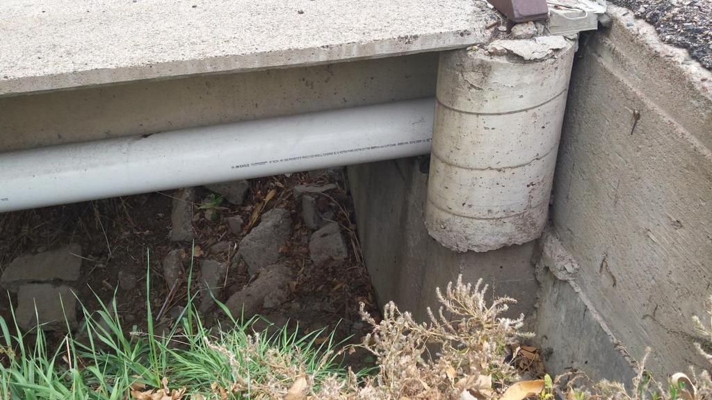
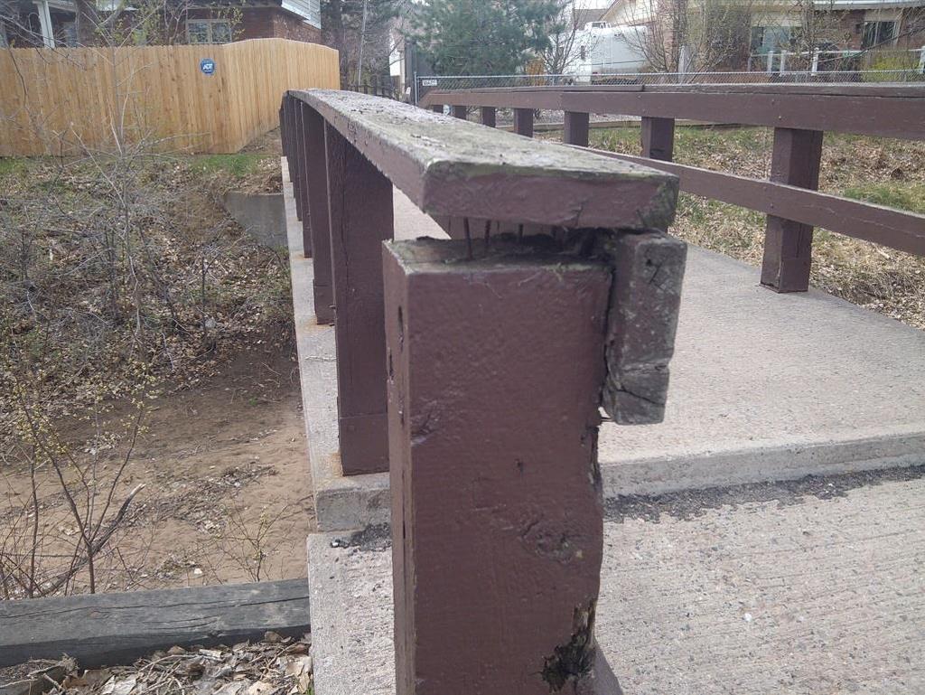
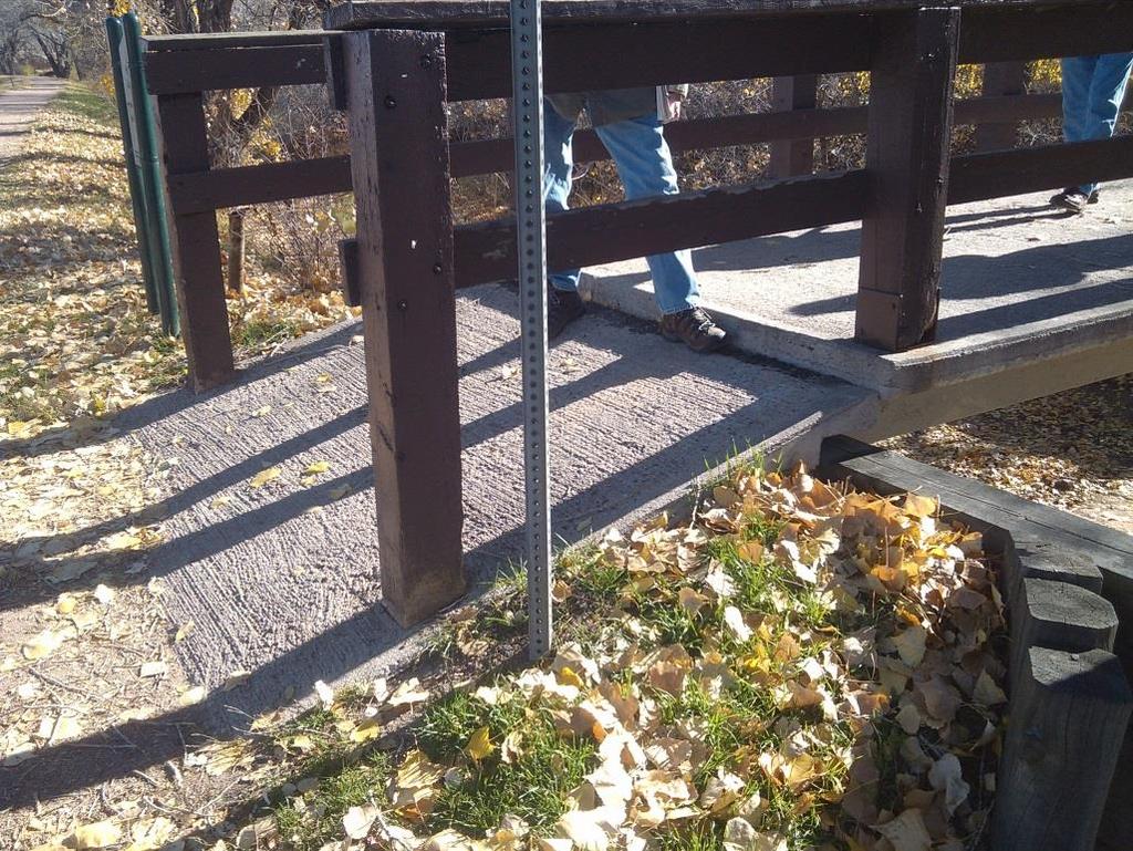
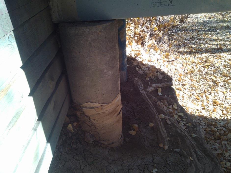
11 Crumbling infrastructure 11


12 Proposed Project: Install new 8 x 60 bridge and approaches to provide access to the High Line Canal Trail from Broadway Estates, Ben Franklin Pool and Ben Franklin Elementary School #5-New Bridge at S. Franklin St. Estimated Cost:$200,000 12


13 13 Example of bridge design standard Self-weathering Corten steel railings Concrete decks Concrete approaches


14 #6-Access at S. Elati St. Proposed Project: Install a concrete ramp from S. Elati St. to the High Line Canal Trail to improve access Estimated Cost:$50,000 14


15 #7-Milliken Park Restroom Proposed Location Proposed Project: Install flush restroom facility for trail and park users. Nearest restroom downstream is approx. 1.7 miles at dekoevend Park Nearest restroom upstream is approx. 5.3 miles at Writer s Vista Park Estimated Cost: $300,000 15


16 Examples of flush restroom facilities design standards Prefabricated preplumbed, pre-wired building Arapaho Park 16 dekoevend Park
17 Timeline Task Install 5 Bridges Estimated Hours and/or Expected Date to Complete September 2015 Responsible Person/Group South Suburban Parks and Recreation Install Flush Restroom October 2015 South Suburban Parks and Recreation Install trail connections June 2015 South Suburban Parks and Recreation Measurable Objective/Deliverable Remove 4 existing bridges and install new bridges. Install 1 new bridge. Install 1 pre-fabricated flush restroom at Milliken Park Install concrete ramp at S. Elati Street 17
18 18
19 19
20 Budget Project Explanation SSPR Amount City of Littleton City of Centennial ACOS Grant Total High Line Canal Bridge at dekoevend Park Replace bridge at dekoevend parking lot $50,000 $50,000 $100,000 $200,000 Entry High Line Canal Bridge at Franklin Street New bridge at Franklin Street $50,000 $50,000 $100,000 $200,000 High Line Canal Bridge at SSIA Replace bridge at SSIA parking lot $50,000 $50,000 $100,000 $200,000 Miliken Park Restroom Install flush restroom at Milliken Park $75,000 $75,000 $150,000 $300,000 Total Centennial $225,000 $0 $225,000 $450,000 $900,000 High Line Canal Bridge at Bannock Street Remove and replace bridge near $37,500 $37,500 $75,000 $150,000 High Line Canal Bridge at Southbridge Swim and Tennis Bannock Street Remove and replace bridge near Southbridge Swim and tennis $37,500 $37,500 $75,000 $150,000 High Line Canal Elati Street Connection Improve connection from Elati St. to the $25,000 $25,000 $50,000 High Line Canal Total Littleton $75,000 $100,000 $0 $175,000 $350,000 Grand Total $300,000 $100,000 $225,000 $625,000 $1,250,000 20
3. VISION AND GOALS. Vision Statement. Goals, Objectives and Policies
 Vision Statement Queen Creek s interconnected network of parks, trails, open spaces and recreation opportunities provide safe and diverse activities and programs that sustain its unique, small town, equestrian
Working together to leverage limited Funds
 Working together to leverage limited Funds ARAPAHOE COUNTY OPEN SPACES 10 County Budget Conference September 20, 2013 The Power of Partnerships 2013 SORP Conference 5/23/2014 Why Talk About Open Space?
Provide and maintain sufficient public parks, recreation facilities, and open space to meet the recreational needs of County residents and visitors.
 (ROS) Goal Provide and maintain sufficient public parks, recreation facilities, and open space to meet the recreational needs of County residents and visitors. OBJECTIVE ROS.01 The County shall acquire,
The following principles guide the development of goals and strategies to protect and promote these amenities:
 OPEN SPACE/PARKS/TRAILS/RECREATION GOALS/STRATEGIES Cherry Hills Village is a living environment that offers low density development, open areas, public scenic vistas, public trails and public parks. This
GOCO Grants Awarded to Projects in Arapahoe County through June 2015
 Grant Type Open Space Fiscal Year Applicant Project Title Grant Amount 2015 City of Aurora Acres Protected Triple Creek Greenway Corridor Phase 3 $2,050,000.00 0 Planning 2015 Arapahoe County High Line
Special Revenue Funds
 Special Revenue Funds Special Revenue Funds account for the proceeds of specific revenue sources (other than special assessments for major capital projects) that are legally restricted to expenditures
PARTF Scoring System for Grants
 PARTF Scoring System for Grants The members of the N.C. Parks and Recreation Authority use the PARTF scoring system as one of several tools to select grant recipients. Please provide all of the information
RECREATION AND OPEN SPACE ELEMENT GOALS, OBJECTIVES, AND POLICIES
 RECREATION AND OPEN SPACE ELEMENT GOALS, OBJECTIVES, AND POLICIES Goal 7 To provide park facilities, recreation programs, and open space resources that are safe, adequate, and accessible to all City residents,
Mendota Heights 2040 Comprehensive Plan Draft Vers
 4 Parks and Trails The City of Mendota Heights boasts a variety of recreational and open space opportunities. Few cities can claim access to regional trails, riverside and lakeside parks, scenic bluffs
RECREATION, OPEN SPACE AND GREENWAYS ELEMENT GOALS, OBJECTIVES, AND POLICIES
 RECREATION, OPEN SPACE AND GREENWAYS ELEMENT GOALS, OBJECTIVES, AND POLICIES GOAL R-1: DEVELOP A RECREATION, OPEN SPACE AND GREENWAYS SYSTEM AS AN INTEGRAL COMPONENT OF AN OVERALL, COUNTY-WIDE ECONOMIC
Southeast Quadrant Plan
 Southeast Quadrant Plan Southeast Quadrant Distinctive Features Land Use The Southeast Quadrant includes all the area within the planning area that is east of Interstate 5 and south of State Route 44.
Pinellas County Greenways
 Pinellas County Greenways USING GREENWAYS TO LINK OPEN SPACES The Florida Greenways Commission has defined a greenway as...a corridor of protected open space that is managed for conservation and/or recreation.
Chapter 5: Recreation
 Chapter 5: Recreation Introduction and Setting Recreational opportunities within Nevada County are varied, ranging from public parks with intensively used active recreational facilities, to vast tracts
ARROYO PROJECTS ADOPTED CAPITAL IMPROVEMENT PROGRAM BUDGET
 A RROYO P ROJECTS ADOPTED CAPITAL IMPROVEMENT PROGRAM BUDGET FISCAL YEARS 214-218 HAHAMONGNA Priority Description 1 Hahamongna Watershed Park - Implement Master Plan 211,6 211,6 (77565) 2 Hahamongna -
Downtown Denver Morrison. Located 30 minutes from downtown Denver behind the hogback
 Downtown Denver Morrison Located 30 minutes from downtown Denver behind the hogback Founded in 1874 as a passageway gold mines to the west. Morrison is the gateway to the Bear Creek Canyon. Surrounded
Town of Peru Comprehensive Plan Executive Summary
 Town of Peru Comprehensive Plan Executive Communities that plan grow by choice, not by chance. A plan makes growth thoughtful, understandable, and predictable. A plan shows that a community is managing
FY Capital Improvement Program Arroyo Projects
 FY 219-223 Capital Improvement Program FY 218 FY 219 FY 22 FY 221 FY 222 FY 223 1 2 3 4 5 6 7 8 9 1 Hahamongna - Implement Master Plan - Oak Grove Area Improvements (7756) Hahamongna - Implement Master
PARK AND RECREATION MASTER PLAN UPDATE
 PARK AND RECREATION MASTER PLAN UPDATE 2014-2018 Prepared for: Avon Parks, Recreation and Beautification Council (PRBC) and Town of Avon Prepared by: Lehman & Lehman, Inc. 24-Apr-14 Mission Statement The
PARKS. Chapter Introduction
 Chapter 4. PARKS 4.1. Introduction This Parks Element of the 2016 Comprehensive Plan Update provides direction and guidance, based on citizen input, in order to improve and maintain the City s existing
The City shall enhance and improve the accessibility of parks and recreational facilities while protecting their quality. by:
 GOALS, OBJECTIVES AND POLICIES GOAL 1: To provide open space and recreation as an essential element needed for the betterment of the City s character and quality of urban life. The City shall plan for
COMMUNICATION URBAN DESIGN REVIEW BOARD CITY OF DES MOINES, IOWA MAY 16, 2017 MEETING
 COMMUNICATION URBAN DESIGN REVIEW BOARD CITY OF DES MOINES, IOWA MAY 16, 2017 MEETING Subject: Recommendation Prepared by: PRELIMINARY DESIGN REVIEW OF LOCUST STREET BRIDGE CONSTRUCTION & COURT AVENUE,
Clovis Urban Greening Plan. Community Workshop #2 Northwest
 Clovis Urban Greening Plan Community Workshop #2 Northwest Thursday, October 9, 2014 WHAT IS AN URBAN GREENING PLAN? A guide to help the City to improve quality of life for residents Identification of
PUBLIC SPACES MASTER PLAN UPDATE (POPS) Joint Facilities Advisory Commission (JFAC) November 28, 2018
 Joint Facilities Advisory Commission (JFAC) November 28, 2018") PUBLIC SPACES MASTER PLAN UPDATE (POPS) Joint Facilities Advisory Commission (JFAC) November 28, 2018 1 AGENDA POPS Planning Context Timeline Public Input Final POPS Draft Next Steps 2 PLANNING CONTEXT
PUBLIC SPACES MASTER PLAN UPDATE (POPS) Joint Facilities Advisory Commission (JFAC) November 28, 2018 1 AGENDA POPS Planning Context Timeline Public Input Final POPS Draft Next Steps 2 PLANNING CONTEXT
Chapter 9 Community Facilities & Services Plan. Introduction. Cooperative Efforts. Monitoring of Needs
 Chapter 9 Community Facilities & Services Plan Introduction The location of key community facilities such as water, sewer, schools, parks, and roads is important to the provision of the necessary services
Introduction. Chapter 1. Purpose of the Comprehensive Plan Plan Organization Planning Process & Community Input 1-1
 Chapter 1 Introduction Lakewood 2025: Moving Forward Together Purpose of the Comprehensive Plan Plan Organization Planning Process & Community Input 1-1 Purpose of the Comprehensive Plan The Comprehensive
ADOPTED CAPITAL IMPROVEMENT PROGRAM BUDGET ARROYO PROJECTS
 ADOPTED CAPITAL IMPROVEMENT PROGRAM BUDGET ARROYO PROJECTS HAHAMONGNA FY 212-216 Capital Improvement Program Priority Description Total Estimated Costs Appropriated Through FY 211 Adopted FY 212 FY 213
Office of Greenways & Trails Providing Statewide Leadership and Coordination. Southeast Greenways and Trails Summit October 1-3, 2017
 Office of Greenways & Trails Providing Statewide Leadership and Coordination Southeast Greenways and Trails Summit October 1-3, 2017 1 Office of Greenways and Trails The Office of Greenways and Trails
This page intentionally blank.
 This page intentionally blank. Parks, Recreation, and Open Space Chapter Relationship to Vision Vision Parks, Recreation and Open Space Chapter Concepts County Government. County government that is accountable
A citizen s guide to the. Comprehensive Plan. City of Lakeville, Minnesota 1
 A citizen s guide to the Comprehensive Plan 2008 City of Lakeville, Minnesota 1 Introduction The City of Lakeville completed an update of its Comprehensive Plan in 2008. A comprehensive plan is a tool
Support the implementation of Cape Coral's Comprehensive Plan. Protect and utilize the unique natural resources in the City.
 7.0 OVERVIEW - RECOMMENDATIONS Chapter 7 The preparation of the Cape Coral Parks and Recreation Master Plan spanned a period of approximately 12 months. Plan preparation included the input of a wide range
1. Parks & Recreation Neighborhood Parks Community Parks Special Use Sites 2. Open Space 3. Trails
 Appendix A: Park Classifications The intent of parks and recreation classifications is to aid in making acquisition and design decisions for park sites, facilities and the organization of recreation space
Date: April 10, 2017 City Council Work Session April 24, 2017: Status Report on the Comprehensive Plan Update and Transportation Master Plan
 AGENDA REPORT To: From: By: Honorable Mayor and City Council Members Warren Hutmacher, City Manager Sharon Ebert, Director Community Development Date: April 10, 2017 Agenda: City Council Work Session April
City of Nogales General Plan
 Open Space, Parks, Recreation and Trails City of Nogales General Plan Residents of Nogales place a high priority in the development of a comprehensive system of open space, parks, recreation and trails
G. RECREATION AND OPEN SPACE ELEMENT. The following summarizes the Recreation and Open Space Element:
 G. RECREATION AND OPEN SPACE ELEMENT The purpose of the Element is to provide the framework and direction for a comprehensive system of public and private sites for recreation, including, but not limited
Mendota-Lebanon Hills Greenway Master Plan Executive Summary. August draft for more information visit
 Mendota-Lebanon Hills Greenway Master Plan Executive Summary August 2013 draft for more information visit www.hkgi.com/projects/dakota INTRODUCTION The Mendota-Lebanon Hills Greenway Master Plan portrays
RESPONSES TO PUBLIC CONCERNS AND QUESTIONS
 RESPONSES TO PUBLIC CONCERNS AND QUESTIONS Stations and Summary Questions for Public Meeting #2 June 23, 2015 General Questions / Concerns: 1. Is there any way this development can raise revenue for the
6. RECREATION AND OPEN SPACE ELEMENT
 6. RECREATION AND OPEN SPACE Introduction This Recreation and Open Space Element includes Goals, Objectives and Policies (GOP) that apply to the main campus in Gainesville and the Lake Wauburg Recreation
Keyport. Vision for Keyport
 Keyport Vision for Keyport Keyport is a rural, historic waterfront village bounded and limited in size by its natural borders of water and the Naval Undersea Warfare Center. The community consists primarily
RECREATION AND OPEN SPACE ELEMENT
 RECREATION AND OPEN SPACE ELEMENT Last amended August 19, 2008 Table of Contents Objective Page 5.1 Park system defined... 5-1 5.2 Access to parks and recreational facilities... 5-2 5.3 Recreation and
OVERMOUNTAIN VICTORY TRAIL BURKE CALDELL CORRIDOR FEASIBLITY STUDY REQUEST FOR QUALIFICATIONS CALDWELL COUNTY PATHWAYS
 OVERMOUNTAIN VICTORY TRAIL BURKE CALDELL CORRIDOR FEASIBLITY STUDY REQUEST FOR QUALIFICATIONS CALDWELL COUNTY PATHWAYS Caldwell County Pathways along with our co-partners City of Lenoir, Town of Gamewell,
Project Output Indicators for Federal Gas Tax Investments
 Municipalities are required to report results achieved through the investment of federal Gas Tax funds under the Municipal Funding Agreement. AMO uses the indicators listed below to capture the outputs
Regional Context Statement
 Regional Context Statement REGIONAL CONTEXT STATEMENT 3. REGIONAL CONTEXT STATEMENT In 1995, the Provincial Government passed into law the Growth Strategies Act. The purpose of this provincial initiative
Draft Stillwater 2030 Comprehensive Plan- Goals and Policies
 Draft Stillwater 2030 Comprehensive Plan- Goals and Policies Instructions- Review each goal and policy and discuss with group any changes, deletions for additions to the list using your groups pen. Keep
City of Tacoma Planning and Development Services
 Agenda Item D-1 City of Tacoma Planning and Development Services To: Planning Commission From: Elliott Barnett, Planning Services Division Subject: Application #2014-08 Open Space Element Update Meeting
Parks, Trails, and Open space Element
 Parks, Trails, and Open space Element Parks, Trails, and Open Space element Parks, Recreation, and Open Space are important components of the quality of life desired by the residents of Elk Grove. This
PARKS AND RECREATION ELEMENT
 PARKS AND RECREATION ELEMENT TABLE -3 First Priority 1 2 POTENTIAL SAN CARLOS TRAIL CONNECTIONS Crestview to Pulgas Ridge Open Space Preserve and San Francisco Watershed Lands Unimproved City-Owned Parcel
4-Town Comprehensive Plan DRAFT 7/30/07
 4-Town Comprehensive Plan DRAFT 7/30/07 Acknowledgements ning Committee Town of Harrisburg Norman Roof Randy Nicol Town of Martinsburg Terry Thisse Paul Kelly Town of Montague Jan Bagdanowicz Wendy Perry
Lewisville Lake Master Plan Revision Public Information Meeting May 2 & 4, 2017
 Lewisville Lake Master Plan Revision Public Information Meeting May 2 & 4, 2017 Presented By Rob Jordan Lake Manager U.S. Army Corps of Engineers Fort Worth District US Army Corps of Engineers Purpose
Potential Green Infrastructure Strategies May 6, 2015 Workshop
 Potential Green Infrastructure Strategies May 6, 2015 Workshop Background The City of Cortland is developing the Tioughnioga Urban Headwaters Green Infrastructure Action Plan with funding from the National
Preface. Erie. Scranton. Allentown. Pittsburgh. Harrisburg. Philadelphia
 The Southern Alleghenies Region The Southern Alleghenies Region spans the Laurel Highlands and Allegheny Front in the west across the Appalachians to the east. It is comprised of Blair, Bedford, Cambria,
ALLEN CREEK GREENWAY. Citizens Advisory Committee Meeting #5 July 19, Allen Creek Greenway Master Plan. July 2017
 1 ALLEN CREEK GREENWAY MASTER PLAN Citizens Advisory Committee Meeting #5 July 19, 2017 Agenda 2 Final DRAFT Preferred Plan (30 min) Master Plan Document Outline (5 min) Potential Implementation Strategy
8implementation. strategies
 PROGRAM STRATEGIES 8implementation strategies T he implementation actions of this chapter are designed to support and carry out the land use, economic development, transportation, urban design, and program
A larger version of this map is located on the last page of this PDF.
 MAP Committee Input McLoughlin Area Draft Vision Map A larger version of this map is located on the last page of this PDF. 1. The map above is intended to portray a vision for the McLoughlin area. It highlights
BEST PRACTICES FOR PROJECT NOMINATIONS TA Set-Aside Program
 BEST PRACTICES FOR PROJECT NOMINATIONS 2017 TA Set-Aside Program Focus of this presentation Photos Public Support Maps & Exhibits Proposed Budget Design Details Project Evaluation & Selection Criteria
Local Growth Planning in North Central Green Line Communities
 2018 April 30 Page 1 of 6 EXECUTIVE SUMMARY This report outlines a high-level scope for local growth planning for north central Green Line communities. The catalyst for this review is the significant investments
Yadkin River Greenway Feasibility Study Fact Sheet Village of Clemmons, Town of Lewisville, Town of Bermuda Run
 Fact Sheet Village of Clemmons, Town of Lewisville, Town of Bermuda Run Project Background The Yadkin River Greenway Feasibility Study is a joint project with the Village of Clemmons, the Town of Bermuda
Carrboro Greenways Commission January 9 th, 2007
 Carrboro Greenways Commission January 9 th, 2007 Statewide The flooding of Crabtree Valley in the early 1970 s (right before Crabtree Valley Mall was set to open) caused city, state, and federal officials
Marion Street Green Infrastructure Project. Whittier Neighborhood Community Meeting April 18, 2018
 Marion Street Green Infrastructure Project Whittier Neighborhood Community Meeting April 18, 2018 Agenda Water quality and green infrastructure Overview: Marion Street stormwater project Green infrastructure
Section 3 INVENTORY OF RECREATION LAND AND FACILITIES
 Photo of Juan Bautista de Anza Park Section 3 INVENTORY OF RECREATION LAND AND FACILITIES Summary of Findings Park Definitions Summary of Recreation Facilities Other Recreation Facilities Nearby Recreation
Michigan State University Barrier-Free/Accessibility Project Status Summary March 2017
 Projects Completed FY14, FY15 and FY16 (arranged alphabetically) Abrams Planetarium Install automatic door opener on main doors of the Planetarium. Completed: Summer 2016 Cost: $13,000 Akers Hall Renovations
CARMODY PARK MASTER PLAN
 the site Smith Reservoir Cottonwood Lake Kendrick Lake Carmody Rec Center Carmody Middle School Pool Court Play Carmody Pond Sanderson Ditch Sports Fields Foothills Ice Arena Open Field why a master plan?
City Council March 27, Parks, Recreation, and Trails Master Plan
 City Council March 27, 2018 Parks, Recreation, and Trails Master Plan Planning Process Develop Goals and Objectives Inventory of Areas and Facilities Needs Assessment And Identification Public Participation
Canyon Lake Master Plan Revision Public Information Meeting March 18, 2016
 Canyon Lake Master Plan Revision Public Information Meeting March 18, 2016 Marcus Schimank Canyon Lake Manager Capital Regional Office U.S. Army Corps of Engineers Fort Worth District US Army Corps of
CHAPTER 7: Transportation, Mobility and Circulation
 AGLE AREA COMMUNITY Plan CHAPTER 7 CHAPTER 7: Transportation, Mobility and Circulation Transportation, Mobility and Circulation The purpose of the Transportation, Mobility and Circulation Chapter is to
APPENDIX K WINDSOR OFFICIAL PLAN
 CEAA ENVIRONMENTAL ENVIRONMENTAL IMPACT ASSESSMENT AMBASSADOR BRIDGE ENHANCEMENT PROJECT Replacement Span and Plaza Expansion APPENDIX K WINDSOR OFFICIAL PLAN Avalon Consulting Professionals of Ontario,
ULI St. Louis Technical Assistance Panel
 ULI St. Louis Technical Assistance Panel ULI St. Louis Technical Assistance Panel Sponsored by: Citizens for Modern Transit in partnership with METRO ULI St. Louis Mission Statement The mission of the
The Rocky Mountain Arsenal and the Northeast Greenway Corridor Project:
 The Rocky Mountain Arsenal and the Northeast Greenway Corridor Project: Contamination to Collaboration Presented by Howard Kenison Overview of Presentation Rocky Mountain Arsenal Contamination Litigation,
CITY OF CHARLOTTESVILLE, VIRGINIA CITY COUNCIL AGENDA
 CITY OF CHARLOTTESVILLE, VIRGINIA CITY COUNCIL AGENDA Agenda Date: December 16, 2013 Action Required: Adoption of Resolution Presenter: Staff Contacts: Title: James E. Tolbert, AICP, Director of NDS James
Whitemarsh Comprehensive Plan Update: Housing & Land Use. Public Workshop #3: September 20, 2018
 Whitemarsh Comprehensive Plan Update: Housing & Land Use Public Workshop #3: September 20, 2018 Agenda Welcome Process Recap What We ve Heard The Plan Framework Review of Recommended Actions Land Use Housing
Portage County Parks, Trails and Greenways Plan
 Portage County Parks, Trails and Greenways Plan Agenda for Local Planning Meeting Introductory Presentation Why we need a Plan Plan project goals and process Benefits Overview of local planning region
BROOKHILL NEIGHBORHOOD MODEL ZONING MAP AMENDMENT PREFACE TO APPLICATION
 BROOKHILL NEIGHBORHOOD MODEL ZONING MAP AMENDMENT PREFACE TO APPLICATION June 15, 2015 Revised: August 1, 2016 I. VISION Brookhill is a proposed community based upon the principles of Albemarle County
Trail Feasibility and Planning Project for Northern Dutchess County, New York
 for Northern Dutchess County, New York Funded in Part by Grants from the Hudson River Valley Greenway, Land Trust Alliance Conservation Partnership Program and the Thomas Thompson Trust 1 STEERING COMMITTEE
Open Space Planning Capital Project Update
 Information Report Service Area Public Services Date Friday, September 9, 2016 Subject Report Number Open Space Planning Capital Project Update PS-16-22 Executive Summary Purpose of Report The Parks and
TOWN OF BETHLEHEM MEETING SUMMARY LOCAL WATERFRONT REVITALIZATION PROGRAM UPDATE
 TOWN OF BETHLEHEM LOCAL WATERFRONT REVITALIZATION PROGRAM UPDATE MEETING SUMMARY Purpose: LWRP Update Public Workshop #3 Date and Time: October 24, 2017, 6:00 pm - 8:00 pm Location: Town Hall, 445 Delaware
Durango Parks & Recreation Department. Strategic Plan
 Durango Parks & Recreation Department Strategic 2019-2023 Adopted April 2019 Overview The purpose of the adopted 2010 Parks, Open Space, Trails and Recreation Master is to provide a 10-year road map for
Chapter 5: Natural Resources and Environment
 NATURAL RESOURCES AND ENVIRONMENT 5-1 5 Chapter 5: Natural Resources and Environment BACKGROUND AND INTENT Urban expansion represents the greatest risk for the future degradation of existing natural areas,
Implementation Guide Comprehensive Plan City of Allen
 Implementation Guide 2030 Comprehensive Plan City of Allen DRAFT 2015 Implementation Guide Allen 2030 Comprehensive Plan INTRODUCTION The Comprehensive Plan serves as a guide for the growth and development
Recreation, Open Space, Greenway Plan & Smart Agriculture Initiative
 Recreation, Open Space, Greenway Plan & Smart Agriculture Initiative This portion of the Plan represents a follow-up to Section 2, which addressed the natural environment of the two townships. This portion
Joe Pool Lake Master Plan Revision Public Information Meeting May 23, 2017
 Joe Pool Lake Master Plan Revision Public Information Meeting May 23, 2017 Presented By Jason Owen Lake Manager U.S. Army Corps of Engineers Fort Worth District US Army Corps of Engineers Purpose of this
TOWN OF SPRINGFIELD, NEW HAMPSHIRE
 TOWN OF SPRINGFIELD, NEW HAMPSHIRE NATURAL RESOURCES INVENTORY EXECUTIVE SUMMARY March 2008 Prepared by: Watershed to Wildlife, Inc. Natural Resource Consultants 42 Mill Street, Suite 3 Littleton, NH 03561
PREVIOUS PUBLIC PARTICIPATION BRIEF October 2014
 Comprehensive Planning During the development of the county comprehensive plan, Cultivating Community: A Plan for Union County s Future from 2007 through 2009, and three concurrent multi municipal plans
Northeast Quadrant Plan
 Northeast Quadrant Plan Northeast Quadrant Distinctive Features Land Use The Northeast Quadrant includes all the area within the planning area that is east of Interstate 5 and to the north of State Route
Mississippi Skyway Preliminary Engineering Report
 EXECUTIVE SUMMARY Mississippi Skyway Preliminary Engineering Report CITY OF RAMSEY, MINNESOTA DECEMBER 2014 City of RAMSEY EXECUTIVE SUMMARY Project Need and Intent The Mississippi Skyway pedestrian bridge
ESTABLISH AN EFFICIENT TOWN CENTER
 ESTABLISH AN EFFICIENT TOWN CENTER 4 Overview Lisbon residents are proud of the history of Newent and at the same time recognize its current importance as a centralized location for a variety of municipal
Mary Norwood. Mayoral Forum on Greenspace Responses
 1. What do you believe is the single most pressing issue impacting Atlanta s urban forest and greenspace, and how would you solve that issue? Preserving and Protecting Atlanta s forest cover Lungs of Atlanta
The Trinity River Corridor Project Update
 The Trinity River Corridor Project Update Councilmember Carolyn A. Davis Community Meeting October 14, 2008 The project covers 20 miles of the Trinity River, approx. 10,000 acres 2 Trinity River Corridor
Elm Fork Land Use. Trinity River Corridor Project Committee May 13, 2013
 Elm Fork Land Use Trinity River Corridor Project Committee May 13, 2013 Purpose Discuss Trinity River planned Land Use and Appropriate Compatible Uses, particularly with respect to the Elm Fork Area 2
CHAPTER 1 Introduction
 CHAPTER 1 Introduction From sea to summit, Lane County covers almost 4,800 square miles of diverse Oregon landscape. Stretching from the Pacific Ocean through the Coastal Range, the Willamette Valley to
PARKS & RECREATION SUBCOMMITTEE. Oct. 1, 2015
 PARKS & RECREATION SUBCOMMITTEE Oct. 1, 2015 1999 Bond - $22,000,000 Land Acquisition Allen Station Phase II Neighborhood Parks PREVIOUS BOND ELECTIONS 1999 & 2007 2002 Bond - $4,000,000 Allen Senior Recreation
Parks, Trails, and Open Space Element
 P arks, Recreation, and Open Space are important components of the quality of life desired by the residents of Elk Grove. This Element of the General Plan addresses the City s goals, policies, and actions
WARM SPRINGS PARK MASTER PLAN
 TABLE OF CONTENTS page 1.0 Introduction and Overview 1 2.0 Information Gathering 2 3.0 Conceptual Alternative Development 8 4.0 Master Plan Development 14 5.0 Construction Cost Estimates 19 LIST OF FIGURES
Central Platte Valley Auraria District Amendment. Steering Committee Meeting #
 Central Platte Valley Auraria Amendment Steering Committee Meeting #1 4.26.2017 Central Platte Valley Auraria Amendment Welcome of Steering Committee Members Co-Chairs: Tami Door & Bar Chadwick Brief Introductions
THREE-YEAR CAPITAL IMPROVEMENT PLAN FY
 THREE-YEAR CAPITAL IMPROVEMENT PLAN FY2016 2018 Annual CIP Development Process Public Works & Engineering Divisions Prepare List of Capital Needs and Recommended Deferred Maintenance Public Works & Engineering
The transportation system in a community is an
 7 TRANSPORTATION The transportation system in a community is an important factor contributing to the quality of life of the residents. Without a sound transportation system to bring both goods and patrons
29 Bella Fontaine Park
 29 Bella Fontaine Park 9565 Bellefontaine Road St. Louis County Parks Master Plan Planning Zone 2 Visit Date: July 2016 Page 1 129 Bella Fontaine Park 9565 Bellefontaine Road St. Louis County Parks Master
SECTION FOUR: MISSION STATEMENT, GOALS & OBJECTIVES
 SECTION FOUR: MISSION STATEMENT, GOALS & OBJECTIVES Chapter Summary Chapter Ten: Mission Statement, Goals & Objectives To fulfill its mission, the Parks and Recreation Commission has identified four basic
APPENDIX G LAND USE INVENTORY STUDY REPORT
 APPENDIX G LAND USE INVENTORY STUDY REPORT Study 10.0 - Land Use Inventory Land Use Inventory Loup River Hydroelectric Project FERC Project No. 1256 Study 10.0 Land Use Inventory August 26, 2010 2010 Loup
GOALS, OBJECTIVES, POLICIES & PROGRAMS
 Chapter 5 GOALS, OBJECTIVES, POLICIES & PROGRAMS 5.1 Goals, Objectives, Policies & Programs This is a joint plan adopted by both the Village of Waunakee and the Town of Westport. Both communities will
Planning Districts INTRODUCTION
 INTRODUCTION To facilitate detailed examination of development prospects for all areas of the community, Delano has been divided into 14 planning districts. The location of these planning districts is
TO: Denver Planning Board FROM: Analiese Hock, Senior City Planner DATE: March 13, 2018 RE:
 Community Planning and Development Planning Services 201 W. Colfax Ave., Dept. 205 Denver, CO 80202 p: 720.865.2915 f: 720.865.3052 www.denvergov.org/cpd TO: Denver Planning Board FROM: Analiese Hock,