Rezoning Issues Setting a Foundation for Zoning Decisions
|
|
|
- Gregory Lester
- 5 years ago
- Views:
Transcription
1 Rezoning Issues Setting a Foundation for Zoning Decisions City Council Workshop May 2, 2016
2 Agenda Goal Need actionable items and sequence of steps Foundation for Zoning Decisions Council Workshop Discussion (April 4 th ) Topic Focus: Zoning & Transportation Discussion & Next Steps 2
3 Foundation for Zoning Decisions 1. Plan Consistency 2. Character & Context 3. Community Infrastructure - Transportation - Schools - Other (water/sewer, police/fire, etc.) 4. Community Resources - Archeological - Environmental - Historical - Cultural 5. Affordable Housing 3
 Whether the proposed reclassification is consistent with the purposes, goals, objectives, and policies of the adopted \"Generalized Land Plan\" and any amendment to that plan")
4 Foundation for Zoning Decisions Plan Consistency In considering any petition to reclassify property, the City Council shall consider the following items: (Sec a of the Zoning Ordinance) Whether the proposed reclassification is consistent with the purposes, goals, objectives, and policies of the adopted "Generalized Land Plan" and any amendment to that plan through an adopted district or area plan covering the subject property; 4
5 Foundation for Zoning Decisions Character & Context In considering any petition to reclassify property, the City Council may consider, although is not required to, the following: Whether the proposed reclassification is compatible with the overall character of existing development in the immediate vicinity of the subject property; (Sec of the Zoning Ordinance) 5
6 Foundation for Zoning Decisions Community Infrastructure In considering any petition to reclassify property, the City Council may consider, although is not required to, the following: (Sec of the Zoning Ordinance) The adequacy of public facilities and services intended to serve the subject property, including but not limited to roadways parks and recreational facilities police and fire protection schools stormwater drainage systems water supplies, and wastewater treatment garbage services 6
7 Foundation for Zoning Decisions Community Resources In considering any petition to reclassify property, the City Council may consider, although is not required to, the following: (Sec of the Zoning Ordinance) Whether the proposed reclassification will adversely affect a known archaeological environmental historical or cultural resource 7
8 Foundation for Zoning Decisions Affordable Housing In considering any petition to reclassify property, the City Council shall not: (Sec of the Zoning Ordinance) Discriminate against affordable housing units for families or individuals with incomes below eighty percent (80%) of area median income. Reclassification of property by the City Council based on considerations of limiting high concentrations of affordable housing is permissible. Per General Statute: 41A-4 & 41-A-5(a) 8
9 Foundation for Zoning Decisions Council Discussion Plan Consistency Council Comments (April 4 th Workshop) Where is the vision? List of issues is incremental. Focus where we want more intense development to go. Are we getting investment in all of Charlotte? Jobs where people live Reinvestment in aging neighborhoods Should be implementing plans. Events/development is outrunning the plans and tools. Area plans are outdated, but the train needs to continue to run. Can Council help prioritize areas to focus on? 9

10 Foundation for Zoning Decisions Council Discussion Character & Context Council Comments (April 4 th Workshop) The Big Picture - Make a place everyone is proud to live in. Are we really creating walkable places or just increasing vehicle traffic? Too many variances Are we addressing live/work/play mixed use projects, job creation. 10
11 Foundation for Zoning Decisions Council Discussion Community Infrastructure Council Comments (April 4 th Workshop) Break the City into segments and define capacity? Pace of growth is out-pacing our ability to serve What is the real cost of development? How do we share cost? What options do we have to mitigate the impact of growth? Need to educate the public on the cost of growth. How do we get ahead of growth? (e.g. Northlake) Need transportation options & diversity (8-80). Need transportation options in low income areas Collaboration with school system define our role and manage expectations Open Space? 11
 Historic Preservation?")
12 Foundation for Zoning Decisions Council Discussion Community Resources Council Comments (April 4 th Workshop) Do no harm, ensure we protect value (preserve and increase) Historic Preservation? Environmental Stormwater is behind and underfunded 12
13 Foundation for Zoning Decisions Council Discussion Affordable Housing Council Comments (April 4 th Workshop) Concern over the consistency and implementation of continued case-by-case negotiation. Affordable housing vs. workforce (need to define) 13
14 Questions & Discussion 14
15 Foundation for Zoning Decisions Conditional Rezoning Foundation for Zoning Decisions Conditional Rezoning Plan Consistency Other Considerations Negotiations Area Plans Future Land Use Centers, Corridors & Wedges Growth Framework General Development Polices Character & Context Community Infrastructure Community Resources Affordable Housing Site design Scale transitions Street activation Open space Access & connectivity Transportation mitigation Architectural design Affordable housing Environmental preservation 15


16 Foundation for Zoning Decisions New Development Ordinance A New Unified Development Ordinance That reflects the character and vision of Charlotte as it grows Provides a clear vision of the community we want to create Easy for the community to use & understand New & refined districts that minimize the reliance on conditional rezoning Links all our development ordinances and policies together 16

17 Foundation for Zoning Decisions Community Character Manual Place-Based Ordinance Foundation Community Character Manual (CCM) Place-types will function as the foundation for zoning districts Place types reinforce existing quality & character and/or facilitate change where desired Place types established by the CCM will provide clear link to Zoning Map Each place type may result in multiple zoning districts 17
18 Questions & Discussion 18
19 Foundation for Zoning Decisions 1. Plan Consistency 2. Character & Context 3. Community Infrastructure - Transportation - Schools - Other (water/sewer, police/fire, etc.) 4. Community Resources - Archeological - Environmental - Historical - Cultural 5. Affordable Housing 19
20 Zoning & Transportation Overview Zoning & Transportation What are the Issues? Regional Growth & By-Right Development Rezoning Evaluation Key Policy Questions Role of Transportation Action Plan 20


 Congestion & impacts on neighborhoods Safety")
21 Zoning & Transportation Issues Transportation Issues Need transportation options and diversity (8-80 Cities concept) Are we really creating walkable places or just increasing vehicle traffic? Focus where we want more intense development to go. More transportation options in low income areas (e.g. transit, shuttles, etc.) Congestion & impacts on neighborhoods Safety Incomplete sidewalks & pedestrian crossings Disconnected bicycle network 21
22 Zoning & Transportation Ongoing Regional Growth Rank City Population 1 New York City 8,491,000 2 Los Angeles 3,929,000 3 Chicago 2,722,000 4 Houston 2,240,000 5 Philadelphia 1,560,000 6 Phoenix 1,537,000 7 San Antonio 1,437,000 8 San Diego 1,381,000 9 Dallas 1,281, San Jose 1,016, Austin 913, Jacksonville 853, San Francisco 852, Indianapolis 849, Columbus 836, Fort Worth 812, Charlotte (2014) 810, Detroit 680, El Paso 679, Seattle 668, Denver 664, Washington 659, Memphis 657, Boston 656, Nashville 644, ,000 (44 new residents per Day) Rank City Population 1 New York City 8,491,000 2 Los Angeles 3,929,000 3 Chicago 2,722,000 4 Houston 2,240,000 5 Philadelphia 1,560,000 6 Phoenix 1,537,000 7 San Antonio 1,437,000 8 San Diego 1,381,000 9 Dallas 1,281,000 Charlotte (2040) 1,200, San Jose 1,016, Austin 913, Jacksonville 853, San Francisco 852, Indianapolis 849, Columbus 836, Fort Worth 812, Detroit 680, El Paso 679, Seattle 668, Denver 664, Washington 659, Memphis 657, Boston 656, Nashville 644,000 22
 More people will mean more development. Most development will happen without rezoning. Travel demand will increase with or without rezoning.")
23 Zoning & Transportation Congestion in the Charlotte Region Population by Metropolitan Areas Charlotte (23) Charlotte is ranked 23rd nationally in population, and ranks 25 th in congestion. Congestion Index by Metropolitan Areas Charlotte (25) More people will mean more development. Most development will happen without rezoning. Travel demand will increase with or without rezoning. (Congestion rankings by Inricks) 23
24 Zoning & Transportation Transportation Action Plan Charlotte s comprehensive transportation plan Adopted in 2006; updated every five (5) years Includes funding plan for transportation projects to address existing and anticipated needs The plan also recognizes need for funding partnerships. The 2016 update is underway with the Transportation and Planning Committee 24

25 Zoning & Transportation By-Right Development Governed by development ordinances. Zoning Tree Ordinance Subdivision Post-Construction Controls No City Council involvement. Development proceeds if ordinance requirements are met. Transportation improvements are typically localized and ensure public safety and provide incremental improvements. 25
 Determine what transportation mitigations are needed beyond")
26 Zoning & Transportation Rezoning Evaluations How does CDOT evaluate a rezoning petition? The basics: Calculate what the expected trip generation of the site will be Conduct traffic studies to identify impacts (in some cases) Determine what transportation mitigations are needed beyond ordinance requirements Ensure consistency with related development ordinances Identify safest and most efficient locations for access Identify opportunities to achieve other transportation goals that may include pedestrian crossings, completing off-site sidewalk gaps, traffic calming, or dedication of public right-of-way for future improvements. 26
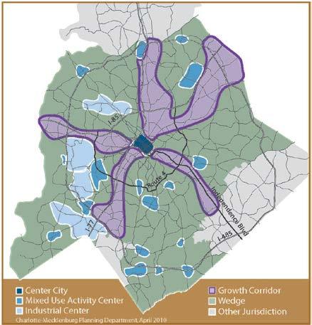
27 Zoning & Transportation Key Policy Questions 1) Why do we support intensification in Transportation Corridors and Activity Centers? Answer: If the growth is inevitable, the question is not how much new development should the city support; the question is where should it go? Activity Centers and Transportation Corridors offer the best chances for transportation capacity now and in the future. Adopted Policy Guidance: Centers Corridors and Wedges Growth Framework 27
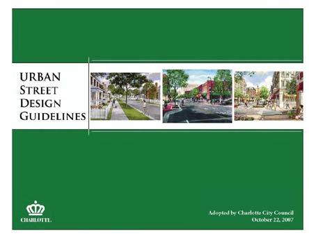
28 Zoning & Transportation Key Policy Questions 2) Why aren t we fully mitigating the impacts of traffic? Answer: Sometimes we do. In greenfield development, new infrastructure is often created commensurate with development impacts. However, eventually the number of travel lanes and turn lanes needed to offset the impact of development creates other problems, including impacts to neighborhoods and barriers to walking, cycling, and transit access. Adopted Policy Guidance: Urban Street Design Guidelines 28
29 Zoning & Transportation Key Policy Questions 3) Why do we try to connect streets together if that creates cut-through traffic in neighborhoods? Answer: Many of the greatest transportation challenges Charlotte faces stem from patterns of disconnected neighborhoods and land uses. Making new street connections can help shorten vehicle trips, reduce pressure on arterial streets, and provide better options for walking and biking. Charlotte employs the use of traffic calming devices to help mitigate the effect of higher volumes and speeds. Adopted Policy Guidance: Connectivity Policy Statements (Incorporated into TAP) 29


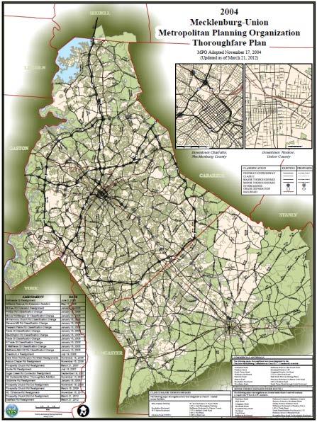
30 Zoning & Transportation Key Policy Questions 4) What are we doing about the cumulative impact of each development? When do we say there is too much congestion? Answer: Charlotte does not have a policy that governs when there is too much congestion. We have focused on form and scale as being appropriate or not. Area plans provide guidance on the types and intensities of uses that are appropriate. The area plans are informed by the Centers Corridors and Wedges Growth Framework, and various transportation plans, including the Thoroughfare Plan, and the Transit System Plan. 30

31 Zoning & Transportation Transportation Action Plan Policies Projects 31
32 Questions & Discussion 32
33 Foundation for Zoning Decisions Questions for Council: Any issues not identified? What are your priorities? 1. Plan Consistency 2. Character & Context 3. Community Infrastructure - Transportation - Schools - Other (water/sewer, police/fire, etc.) 4. Community Resources - Archeological - Environmental - Historical - Cultural 5. Affordable Housing 33
34 Next Steps Goal Need actionable items and sequence of steps June Workshop Identify & prioritize concerns & issues Discussion of short & long term policy considerations 34
Transportation Land Use Integration & Regional Planning. Don Kostelec, AICP Senior Planner, Louis Berger Group February 1, 2010
 Transportation Land Use Integration & Regional Planning Don Kostelec, AICP Senior Planner, Louis Berger Group February 1, 2010 Transportation Land Use Integration DOT-HUD-EPA Sustainable Communities Initiative
Land Use Policy & Development Ordinance Update
 Land Use Policy & Development Ordinance Update Charlotte Chamber of Commerce, Land Use Committee July 27, 2016 Land Use Policy & Development Ordinance Update Land Use Policy & Development Ordinance Update
Planning Charlotte s Future. Transportation & Planning Committee March 14, 2016
 Planning Charlotte s Future Transportation & Planning Committee March 14, 2016 Charlotte s Vision Livable city Vibrant economy Thriving natural environment Diverse population Choices for housing, education,
A BLUEPRINT FOR BROCKTON A CITY-WIDE COMPREHENSIVE PLAN
 A BLUEPRINT FOR BROCKTON A CITY-WIDE COMPREHENSIVE PLAN Public Meeting October 2016 1 Plan Summary and Discussion Public Meeting May 4 2017 City of Brockton Bill Carpenter, Mayor Department of Planning
Planning Charlotte s Future. Planning Committee May 17, 2016
 Planning Charlotte s Future Planning Committee May 17, 2016 Place Types: Next Steps March - June Public Input: Education & input on community character and place-type framework Public open house (Transportation
CITY OF CHARLOTTESVILLE, VIRGINIA CITY COUNCIL AGENDA
 CITY OF CHARLOTTESVILLE, VIRGINIA CITY COUNCIL AGENDA Agenda Date: December 16, 2013 Action Required: Adoption of Resolution Presenter: Staff Contacts: Title: James E. Tolbert, AICP, Director of NDS James
SAN RAFAEL GENERAL PLAN 2040 INTRODUCTION AND OVERVIEW
 SAN RAFAEL GENERAL PLAN 2040 INTRODUCTION AND OVERVIEW Steering Committee Presentation February 14, 2018 Purpose of General Plan Guide land use and development decisions Coordinate transportation, infrastructure,
ITEM #8. Regional Smart Growth Program. Regional Smart Growth Program. Presentation Overview. Coast Highway Vision and Stategic Plan.
 Regional Smart Growth Program Economic Development Commission What is Smart Growth? Adopted as part of the Regional Comprehensive Plan (RCP) RCP provides vision for region based on Smart Growth and sustainability
Executive Summary. NY 7 / NY 2 Corridor
 Executive Summary NY 7 / NY 2 Corridor Transportation and Land Use Study December 2005 Prepared for: Town of Colonie Capital District Transportation Committee Prepared by: Introduction: Land use decisions
Implementation Guide Comprehensive Plan City of Allen
 Implementation Guide 2030 Comprehensive Plan City of Allen DRAFT 2015 Implementation Guide Allen 2030 Comprehensive Plan INTRODUCTION The Comprehensive Plan serves as a guide for the growth and development
Planning Charlotte s Future. Planning Committee June 21, 2016
 Planning Charlotte s Future Planning Committee June 21, 2016 Charlotte s Vision Livable city Vibrant economy Thriving natural environment Diverse population Choices for housing, education, employment Safe
Blueprint Denver A BLUEPRINT FOR AN INCLUSIVE CITY. Executive Summary
 Blueprint Denver A BLUEPRINT FOR AN INCLUSIVE CITY Executive Summary PUBLIC REVIEW DRAFT 2 1/7/2019 DENVERIGHT BLUEPRINTDENVER Blueprint Denver: A Blueprint for an Inclusive City An Equitable City Planning
Welcome to the Oakridge Centre Open House
 Welcome to the Oakridge Centre Open House Why is the City hosting this event? This open house is to inform you of a rezoning application submitted to the City of Vancouver to amend the existing CD-1 (Comprehensive
CHAPTER 7: Transportation, Mobility and Circulation
 AGLE AREA COMMUNITY Plan CHAPTER 7 CHAPTER 7: Transportation, Mobility and Circulation Transportation, Mobility and Circulation The purpose of the Transportation, Mobility and Circulation Chapter is to
TOD 101 CREATING LIVABLE COMMUNITIES WITH TRANSIT
 1 CREATING LIVABLE COMMUNITIES WITH TRANSIT What are transit Centered Communities? Benefits of Partnerships to Support and Implement What You Will Learn Portland s Pearl District Your Trainers Today Catherine
Independence Boulevard Area Plan Planning Committee Public Comment May 18, 2010
 Independence Boulevard Area Plan Planning Committee Public Comment May 18, 2010 Presentation Outline Focus on Key Recommendations within Draft Plan Plan Purpose and Development Process Draft Plan Policies
INDEPENDENCE BOULEVARD AREA PLAN. Economic Development Committee Overview March 10, 2011
 INDEPENDENCE BOULEVARD AREA PLAN Economic Development Committee Overview March 10, 2011 Presentation Outline Purpose: To provide an overview of the Independence Boulevard Area Plan and to request a recommendation
2040 LUP is a part of the Comprehensive Plan and carries the same legal authority. Economic Challenges
 1.1. Guiding Anchorage s Growth Where will new residents settle over the next two decades? Where will people work, shop, and play? Will there be enough room to grow? How will Anchorage look? Will growth
Corridor-Level Approaches to Creating Transit-Oriented Districts
 Corridor-Level Approaches to Creating Transit-Oriented Districts Dena Belzer Strategic Economics and Center for Transit-Oriented Development August 2011 5-year old partnership dedicated to improving practice
A. WHAT IS A GENERAL PLAN?
 I. Introduction A. WHAT IS A GENERAL PLAN? A general plan is the planning guideline for the future of a city. It contains goals and policies which regulate urban development, the protection of the natural
International Blvd. TOD Plan Public Workshop #1
 International Blvd. TOD Plan Public Workshop #1 Add photos or project images September 21 and 22, 2010 Workshop Purpose Introduce the public to the Project Review and discuss the existing conditions analysis
Preliminary Plan Framework: Vision and Goals
 Preliminary Plan Framework: Vision and Goals Draft: May 2015 Introduction Since the Town of Milliken s comprehensive plan was last updated in 2010, the community was heavily impacted by the 2013 flood,
Public Open House. Overview of the Downtown Plan Official Plan Amendment April 23, 2018
 Public Open House Overview of the Downtown Plan Official Plan Amendment April 23, 2018 1 A 25-Year Plan for Downtown To ensure growth contributes positively to Toronto s Downtown as a great place to live,
PSRC REVIEW REPORT & CERTIFICATION RECOMMENDATION
 PSRC REVIEW REPORT & CERTIFICATION RECOMMENDATION KITSAP COUNTY COUNTYWIDE PLANNING POLICIES July 2, 2012 BACKGROUND A major emphasis of the Washington State Growth Management Act (GMA) is the need to
Plano Tomorrow Vision and Policies
 Plano Tomorrow Vision and Policies PLANO TOMORROW PILLARS The Built Environment The Social Environment The Natural Environment The Economic Environment Land Use and Urban Design Transportation Housing
TENNESSEE STATE ROUTE 109 CORRIDOR MANAGEMENT AGREEMENT MEMORANDUM OF UNDERSTANDING CORRIDOR MANAGEMENT ALONG STATE ROUTE 109
 TENNESSEE STATE ROUTE 109 CORRIDOR MANAGEMENT AGREEMENT MEMORANDUM OF UNDERSTANDING CORRIDOR MANAGEMENT ALONG STATE ROUTE 109 I. Purpose The purpose of this Agreement is to provide a framework for the
40 Years of Smart Growth Arlington County s Experience with Transit Oriented Development in the Rosslyn-Ballston Metro Corridor
 40 Years of Smart Growth Arlington County s Experience with Transit Oriented Development in the Rosslyn-Ballston Metro Corridor A presentation by the Arlington County Department of Community Planning,
Introduction. Chapter 1. Purpose of the Comprehensive Plan Plan Organization Planning Process & Community Input 1-1
 Chapter 1 Introduction Lakewood 2025: Moving Forward Together Purpose of the Comprehensive Plan Plan Organization Planning Process & Community Input 1-1 Purpose of the Comprehensive Plan The Comprehensive
Table A-4...Professional and Do-It-Yourself Improvement Expenditures by Homeowner Characteristics: 2007
 Appendix Tables Table A-1... Homeowner Improvement : 2007 Table A-2...Professional and Do-It-Yourself Home Improvement : 2007 Table A-3... Improvement by Homeowner Characteristics: 2007 Table A-4...Professional
Horizon 2035 Land Use and Transportation Element
 CITY OF SUNNYVALE Horizon 2035 Land Use and Transportation Element City Council Study Session March 7, 2017 Overview General Plan Context Mixed Use Villages Transportation Mode & Parking General Plan Policy
JANUARY 19, 2011 CENTRAL AVENUE-METRO BLUE LINE TRANSIT-ORIENTED DEVELOPMENT IMPLEMENTATION PROJECT COMMUNITY FORUM
 CENTRAL AVENUE-METRO BLUE LINE TRANSIT-ORIENTED DEVELOPMENT IMPLEMENTATION PROJECT COMMUNITY FORUM JANUARY 19, 2011 THE MARYLAND-NATIONAL CAPITAL PARK AND PLANNING COMMISSION PRINCE GEORGE S COUNTY PLANNING
Roosevelt Corridor. R e i n v e s t m e n t P l a n. Public Meeting Gilbert Elementary School May 12, :00 pm
 Roosevelt Corridor R e i n v e s t m e n t P l a n Public Meeting Gilbert Elementary School May 12, 2009 6:00 pm Agenda 6:00 6:10 6:25 6:40 6:55 7:00 Opening Comments Councilwoman Jennifer V. Ramos District
Urban Planning and Land Use
 Urban Planning and Land Use 701 North 7 th Street, Room 423 Phone: (913) 573-5750 Kansas City, Kansas 66101 Fax: (913) 573-5796 Email: planninginfo@wycokck.org www.wycokck.org/planning To: From: City Planning
TOD IMPLEMENTATION BEST PRACTICE TOOLBOX Leveraging Transit for City Shaping
 arrington.gb@gmail.com gbplacemaking.com THE TOD I LIVE IN ~ PORTLAND, OR TOD IMPLEMENTATION BEST PRACTICE TOOLBOX Leveraging Transit for City Shaping BEST PRACTICE TOPICS Timing & transit Parking & retail
40 Years of Smart Growth Arlington County s Experience with Transit Oriented Development in the Rosslyn-Ballston Metro Corridor
 40 Years of Smart Growth Arlington County s Experience with Transit Oriented Development in the Rosslyn-Ballston Metro Corridor A presentation by the Arlington County Department of Community Planning,
CHAPTER 3 VISION, GOALS, & PLANNING PRINCIPLES. City of Greensburg Comprehensive Plan. Introduction. Vision Statement. Growth Management Goals.
 CHAPTER 3 VISION, GOALS, & PLANNING PRINCIPLES Introduction The Greensburg Comprehensive Plan is intended as a working community document. A combination of long and short-term goals, this document is intended
Partnerships in Transportation Transit-oriented Development The Return on Investment
 Partnerships in Transportation Transit-oriented Development The Return on Investment David M. Taylor, CNU Senior Vice President National Director, Sustainable Transportation Solutions Transit and Development
Chapter 2: Vision, Goals and Strategies
 Chapter 2: Vision, Goals and Lake Elmo Today & Tomorrow Comprehensive Plan 2040 2 VISION, GOALS & STRATEGIES - DRAFT 4-6-2018 INTRODUCTION Comprehensive Plan Purpose Perhapse the most important objective
Comprehensive Plan. Faribault, Minnesota. Hoisington Koegler Group Inc. Claybaugh Preservation Architecture Inc. Howard R. Green Company Bonz/REA
 Comprehensive Plan Faribault, Minnesota Adopted by the Faribault City Council July 8, 2003 prepared for: prepared by: Hoisington Koegler Group Inc. Claybaugh Preservation Architecture Inc. Howard R. Green
Cobb County Design Guidelines Mableton Parkway & Veterans Memorial Highway Community Design Workshop January 12, 2017
 Community Design Workshop January 12, 2017 Agenda Opening Remarks / Introductions Scope of Work Existing Conditions Key Issues / Opportunities VPS Summary Draft Vision & Goal Statement Implementation Concepts
DRAFT PLAN PRESENTATION
 DRAFT PLAN PRESENTATION 1.23.2018 AGENDA Process Project Schedule Results from Visioning Workshop Draft Plan Highlights Concept Plans Feedback Next Steps PROJECT SCHEDULE KICK-OFF WORKSHOP August 29 th
Economic Development & Housing Council Committee Comprehensive Plan Update September 20, 2005
 1 Economic Development & Housing Council Committee Comprehensive Plan Update September 20, 2005 Purpose To update the Committee on the ForwardDallas! Plan, including: Status Anticipated Products Public
Official Plan Review
 Official Plan Review Summary Report - The Built Environment August 2014 Part 1: Introduction Planning for a healthy, prosperous and sustainable community is an important goal for our municipality. From
SUMMERSIDE / MT. CARMEL REINVESTMENT CORRIDOR COMMUNITY DEVELOPMENT STRATEGY
 SUMMERSIDE / MT. CARMEL REINVESTMENT CORRIDOR COMMUNITY DEVELOPMENT STRATEGY FEBRUARY 2013 I. Location of the Summerside/Mt. Carmel Reinvestment Corridor The Summerside/Mt. Carmel Reinvestment Corridor
Table W-4...Total Improvement Expenditures by Homeowner Characteristics:
 6APPENDIX TABLES Table A-1... Homeowner Improvement s: 2011 Table A-2...Professional and Do-It-Yourself Home Improvement s: 2011 Table A-3... Improvement s by Homeowner Characteristics: 2011 Table A-4...Professional
KEY FINDINGS. Community Engagement + Research
 PROJECT OVERVIEW PROJECT OVERVIEW PROJECT OVERVIEW KEY FINDINGS Community Engagement + Research Community Engagement Community Issues Workshop Steering Committee Workshop City Council/Planning Workshop
CITY CLERK. Parkland Acquisition Strategic Directions Report (All Wards)
") CITY CLERK Clause embodied in Report No. 10 of the, as adopted by the Council of the City of Toronto at its meeting held on November 6, 7 and 8, 2001. 10 Parkland Acquisition Strategic Directions Report
CITY CLERK Clause embodied in Report No. 10 of the, as adopted by the Council of the City of Toronto at its meeting held on November 6, 7 and 8, 2001. 10 Parkland Acquisition Strategic Directions Report
REVIEW AND EVALUATION OF REGIONAL LAND USE
 REVIEW AND EVALUATION OF REGIONAL LAND USE AND TRANSPORTATION SCENARIOS #220831 Environmental Justice Task Force October 7, 2014 VISION 2050 Process Development of Guiding Vision for Land Use and Transportation
DRAFT Amsterdam/Churchill Community Plan (4/17/08) Adopted By the Gallatin County Commission
 Adopted By the Gallatin County Commission") DRAFT Amsterdam/Churchill Community Plan (4/17/08) Adopted By the Gallatin County Commission Table of Contents Acknowledgements Chapter 1: Introduction A Brief History What s Next Authority Organization
DRAFT Amsterdam/Churchill Community Plan (4/17/08) Adopted By the Gallatin County Commission Table of Contents Acknowledgements Chapter 1: Introduction A Brief History What s Next Authority Organization
Route 1 Corridor Study
 Route 1 Corridor Study Westbrook, Connecticut A Vision for the Connecticut Shoreline Public Informational Meeting July 28, 2015 Lower Connecticut River Valley Council of Governments Fitzgerald & Halliday,
Living in Albemarle County s Urban Places
 Living in Albemarle County s Urban Places ALBEMARLE COUNTY, VIRGINIA A Closer Look at Albemarle s Approach to Managing Growth and Creating Quality Urban Environments www.albemarle.org Page 2 Living in
City of Nogales General Plan
 Open Space, Parks, Recreation and Trails City of Nogales General Plan Residents of Nogales place a high priority in the development of a comprehensive system of open space, parks, recreation and trails
Remi Mendoza City Planning Academy March 13, 2017
 Remi Mendoza City Planning Academy March 13, 2017 1 What is the General Plan? The 2030 General Plan 5-Year Update (2035 General Plan) Questions and Answers 2 Guidebook for development and growth Required
India Basin/Hunters Point Shoreline Community Workshop May 21, 2008
 India Basin/Hunters Point Shoreline Community Workshop May 21, 2008 Workshop Agenda Welcome Process Overview Context & Existing Conditions Presentation of Draft Concepts Land Use and Open Space Priorities
Table A-4...Professional and Do-It-Yourself Improvement Expenditures by Homeowner Characteristics: 2013
 6APPENDIX TABLES Table A-1...Homeowner Improvement : 2013 Table A-2...Professional and Do-It-Yourself Home Improvement : 2013 Table A-3...Improvement by Homeowner Characteristics: 2013 Table A-4...Professional
Atlanta BeltLine Subarea 3 Master Plan Update
 Atlanta BeltLine Subarea 3 Master Plan Update April 14, 2018 Workshop Meeting 1 22 miles, connecting 45 neighborhoods 22 MILES of transit 46 MILES of streetscapes and complete streets 33 MILES of urban
INDEPENDENCE BOULEVARD AREA PLAN. June 24, 2008
 INDEPENDENCE BOULEVARD AREA PLAN Public Meeting #1 June 24, 2008 Tonight s Agenda Introduction Welcome and Ground Rules Overview Presentation Purpose of the Plan What Brings Us Here? A Tour of the Corridor
Silverdale Regional Center
 Silverdale Regional Center Vision for Silverdale Regional Center The Silverdale Regional Center Plan (Plan) will guide the evolution of the Silverdale Regional Center from a collection of strip malls and
Broken Arrow Comprehensive Plan Update Public Workshop Meeting #3 January 23,
 Broken Arrow Comprehensive Plan Update Public Workshop Meeting #3 January 23, September 25,2018 2018 26 April 2016 AGENDA 1. Status Presentation - Charrette Recap - Proposed Vision Framework - Preliminary
Date: April 10, 2017 City Council Work Session April 24, 2017: Status Report on the Comprehensive Plan Update and Transportation Master Plan
 AGENDA REPORT To: From: By: Honorable Mayor and City Council Members Warren Hutmacher, City Manager Sharon Ebert, Director Community Development Date: April 10, 2017 Agenda: City Council Work Session April
NEC of Central Avenue and Indian School Road
 NEC of Central Avenue and Indian School Road For this location, there are two applicable plans that provide guidance on development. The two plans include the Indian School Specific Plan (1991) and the
Corridor Vision. 1Pursue Minnehaha-Hiawatha Community Works Project. Mission of Hennepin County Community Works Program
 1Pursue Minnehaha-Hiawatha Community Works Project Minnehaha-Hiawatha Community Works is a project within the Hennepin Community Works (HCW) program. The mission of the HCW program is to enhance how the
V. Vision and Guiding Principles
 V. Vision and Guiding Principles The Master Plan for the Powers Ferry Corridor seeks a foundation in the desires of the community. At times, various elements of the community offered opposing viewpoints,
2030 Comprehensive Plan VISION STATEMENT
 RESOURCE DOCUMENT for Steering Committee Meeting #2 July 12, 2017 2030 Comprehensive Plan VISION STATEMENT Steering Committee from 2008 Established the Lauderdale s Vision as: Creating a livable, lovable
It Takes A Village.. Preserving Rural Character In Standish
 It Takes A Village.. Preserving Rural Character In Standish A Public Workshop Hosted by Conservation and Open Space Plan Committee & Standish Corner Village Implementation Committee June 12, 2008 Desired
CITY OF SACRAMENTO GENERAL PLAN. UC Davis ESP 171 Urban and Regional Planning April 21, 2011
 CITY OF SACRAMENTO GENERAL PLAN UC Davis ESP 171 Urban and Regional Planning April 21, 2011 1 OUTLINE Background Growth and Change Placemaking Sustainability and Climate Change Economic Development 2 City
3. ELEMENTS OF THE METRO VISION 2035 PLAN
 3. ELEMENTS OF THE METRO VISION 2035 PLAN What is Metro Vision and why does it matter? For more than 50 years, DRCOG has championed a regional perspective on key issues facing the metropolitan area and
Steering Committee Meeting
 Neighborhood Planning Initiative NPI EAST CENTRAL AREA PLAN Steering Committee Meeting November 9, 2017 6:00PM 8:00PM Tears McFarlane House East Central Area Plan Steering Committee Meeting 11/9/17 AGENDA
Ranking US Cities Oil Addiction: Sprawl and Car Commuting Emerge as Real Estate Risk Factors
 Ranking US Cities Oil Addiction: Sprawl and Car Commuting Emerge as Real Estate Risk Factors Behavior, Energy and Climate Change November 17, 2008 Warren Karlenzig, President, Common Current www.commoncurrent.com
Public Forum. Kelley s Corner: The Corner that Connects Us. The Cecil Group. March 7, Acton 2020 Town of Acton.
 Public Forum Acton 2020 Town of Acton March 7, 2013 AGENDA Purpose of Forum Kelley s Corner Project Examples of the Planning Processes Next Steps Dialogue: Questions and Answers PURPOSE Acton 2020 April
City of Fort Lauderdale UPTOWN URBAN VILLAGE. Public Workshop December 7, 2016
 Public Workshop December 7, 2016 Workshop Agenda Introductions Project Presentation o o o History Project Scope/Timeline Character of Study Area o o o o Land Use Public Realm/Pedestrian Mobility Multimodal
Rezoning Petition Pre-Hearing Staff Analysis September 17, 2018
 Rezoning Petition 2017-043 Pre-Hearing Staff Analysis September 17, 2018 REQUEST Current Zoning: R-3 (single family residential), R-17MF (multi-family residential), and CC (commercial center) Proposed
Chapter 4. Linking Land Use with Transportation. Chapter 4
 Chapter 4 Linking Land Use with Transportation Chapter 4 59 Chapter 4 Linking Land Use with Transportation Community Design and Transportation Program Introduction Since the 1950s, the predominant development
SDOT DPD. SDOT Director s Rule DPD Director s Rule DCLU DR SED DR of 7 CITY OF SEATTLE
 SDOT SDOT Director s Rule 2-07 DPD Applicant: CITY OF SEATTLE Page 1 of 7 Supersedes: DCLU DR 11-93 SED DR 93-4 Seattle Department of Transportation (SDOT) Department of Planning and Development (DPD)
COLLABORATION BETWEEN CITY, COUNTY, UNIVERSITY AND PROPERTY OWNERS
 COLLABORATION BETWEEN CITY, COUNTY, UNIVERSITY AND PROPERTY OWNERS 2 City-Making Urban Design 3 OFFICES Atlanta Boston Charlotte Chicago Dallas Dubai Dundas Houston London Los Angeles Miami Minneapolis
Cumberland Region Tomorrow is a private, non-profit, citizen based regional organization working with Greater Nashville Regional Council
 Cumberland Region Tomorrow is a private, non-profit, citizen based regional organization working with Greater Nashville Regional Council and others in the public and private sectors, dedicated to planning
Blueprint Denver Task Force Meeting #
 Blueprint Denver Task Force Meeting #1 6.23.16 1. Welcome and Introductions Your name and affiliation Name 1 thing you love about Denver Name 1 thing you d change about Denver All in 30 seconds! Ready,
1.0 Introduction. Purpose and Basis for Updating the TMP. Introduction 1
 1.0 Introduction The Town of Castle Rock is situated between the metropolitan areas of Denver and Colorado Springs, amidst a unique terrain of rolling hills, mesas, ravines, and waterways. Like many Front
THE POLICY FRAMEWORK FOR WALKABLE COMMUNITIES. Community Technical Assistance Program Building Active Communities Institute March 2016
 THE POLICY FRAMEWORK FOR WALKABLE COMMUNITIES Community Technical Assistance Program Building Active Communities Institute March 2016 ACTIVE COMMUNITIES BACK THEN ACTIVE COMMUNITIES BACK THEN Lifestyle
Community Open House March 26 th, 2018
 Community Open House March 26 th, 2018 Open House Agenda 1. Overview of Planning Process What we heard 2. Future Land Use Policy 3. Priority Growth Areas 4. Plan Elements Making it happen What is a Comprehensive
Concord Community Reuse Project Goals and Guiding Principles. Overarching Goals (OG)
") Concord Community Reuse Project Goals and Guiding Principles Overarching Goals (OG) No priority is implied by the order of presentation of the goals and guiding principles. Overarching goals for the Concord
Concord Community Reuse Project Goals and Guiding Principles Overarching Goals (OG) No priority is implied by the order of presentation of the goals and guiding principles. Overarching goals for the Concord
Port Lavaca Future Land Use
 Port Lavaca Future Land Use Introduction The City of Port Lavaca is beginning to see sustained growth, after many years of relative stable population. New single family homes, apartments, and businesses
Onondaga County Sustainable Streets Project. Onondaga County Planning Federation June 7, Onondaga County Sustainable Streets Project 1
 Onondaga County Sustainable Streets Project Onondaga County Planning Federation June 7, 2012 Onondaga County Sustainable Streets Project 1 Sustainable Streets 1. Introduction to the SMTC 2. Sustainable
Asbury Chapel Subdivision Sketch Plan
 Asbury Chapel Subdivision Sketch Plan PART 1: PROJECT SUMMARY Applicant: NVR Inc. Project Size: +/- 76.13 acres Parcel Numbers: 02101112,02116101,02116112, 02116113 Current Zoning: Transitional Residential
Parks, Trails, and Open space Element
 Parks, Trails, and Open space Element Parks, Trails, and Open Space element Parks, Recreation, and Open Space are important components of the quality of life desired by the residents of Elk Grove. This
Unique. Livable. Connected. Sustainable. Anticipate and Manage Change. Variety of Housing Choices. Enhanced Arterial Corridors
 Neighborhood Vision The Old Town Neighborhoods are Unique, Livable, Connected, and Sustainable. As mature, established neighborhoods, many of the ideas and opportunities expressed by stakeholders in support
Burton Station Village Community Meeting February 26, 2014
 February 26, 2014 SGA Plan Overview Recent announcements by the City of Norfolk regarding the closure of Lake Wright Golf Course and retail development proposals Update on infrastructure improvement plans
Streets for People, Place-Making and Prosperity. #TOcompletestreets
 COMPLETE STREETS FOR TORONTO Streets for People, Place-Making and Prosperity COMPLETE STREETS: A NEW APPROACH A Complete Streets design approach considers the needs of all users people who walk, bicycle,
Good Neighbor Plan Dallas Love Field Airport Transportation and Environment Committee
 June 25, 2012 Good Neighbor Plan Dallas Love Field Airport Transportation and Environment Committee Overview Vision for Dallas Love Field Downtown Dallas 360 Plan Targeted Improvement Zones Lemmon Avenue
INDEPENDENCE BOULEVARD AREA PLAN. Economic Development Committee Overview May 25, 2010
 INDEPENDENCE BOULEVARD AREA PLAN Economic Development Committee Overview May 25, 2010 Presentation Outline Plan Purpose and Development Process Draft Plan Policies and Implementation Strategies Request
Draft Bergamot Area Plan
 ATTACHMENT 1 Draft Bergamot Area Plan Taskforce on the Environment April 15, 2013 www.bergamotplan.net 1 Overview WHAT IS THE BERGAMOT AREA PLAN? A Community-Based Planning Document Guiding the Future
LEED-ND 101: Practical Strategies for Achieving Sustainability Goals. Travis Parker Lakewood Planning Director
 LEED-ND 101: Practical Strategies for Achieving Sustainability Goals Travis Parker Lakewood Planning Director Metro Vision Idea Exchange Oct 11, 2012 West Corridor Stations West Corridor Overview West
PLAN ELEMENTS WORKSHOP. April 5, 2016
 PLAN ELEMENTS WORKSHOP April 5, 2016 needs more housing. But there is no one-size fits-all solution. Every neighborhood has its own character. In some places, density is not only appropriate it is badly
A larger version of this map is located on the last page of this PDF.
 MAP Committee Input McLoughlin Area Draft Vision Map A larger version of this map is located on the last page of this PDF. 1. The map above is intended to portray a vision for the McLoughlin area. It highlights
Welcome. Walk Around. Talk to Us. Write Down Your Comments
 Welcome This is an information meeting introducing the applications for proposed redevelopment of the Yorkdale Shopping Centre site at 3401 Dufferin Street and 1 Yorkdale Road over the next 20+ years,
Silver Line CPAM UPDATE. Transportation and Land Use Committee October 14, 2016
 Silver Line CPAM UPDATE Transportation and Land Use Committee October 14, 2016 Purpose Recap Project History and Map Changes Provide Overview of CPAM Components Discuss Transportation Impacts Discuss Fiscal
REZONING GUIDE. Zone Map Amendment (Rezoning) - Application. Rezoning Application Page 1 of 3. Return completed form to
 - Application. Rezoning Application Page 1 of 3. Return completed form to") Zone Map Amendment (Rezoning) - Application COMMUNITY PLANNING & DEVELOPMENT REZONING GUIDE Rezoning Application Page 1 of 3 PROPERTY OWNER INFORMATION* CHECK IF POINT OF CONTACT FOR APPLICATION Property
Zone Map Amendment (Rezoning) - Application COMMUNITY PLANNING & DEVELOPMENT REZONING GUIDE Rezoning Application Page 1 of 3 PROPERTY OWNER INFORMATION* CHECK IF POINT OF CONTACT FOR APPLICATION Property
Scope of Services. River Oaks Boulevard (SH 183) Corridor Master Plan
 Corridor Master Plan") Scope of Services River Oaks Boulevard (SH 183) Corridor Master Plan PROJECT AREA The project area consists of the River Oaks Boulevard (SH 183) corridor bounded by SH 199 at the northern end and the Trinity
Scope of Services River Oaks Boulevard (SH 183) Corridor Master Plan PROJECT AREA The project area consists of the River Oaks Boulevard (SH 183) corridor bounded by SH 199 at the northern end and the Trinity
North Fair Oaks Community Plan Summary and Information
 North Fair Oaks Community Plan Summary and Information WHAT IS THE NORTH FAIR OAKS COMMUNITY PLAN? The North Fair Oaks Community Plan is part of the San Mateo County General Plan, and establishes policies
DRAFT MAP AMENDMENT FLU 04-4
 DRAFT MAP AMENDMENT FLU 04-4 SW 24 TH AVENUE ROADWAY CORRIDOR The University of Florida participates with the Metropolitan Transportation Planning Organization (MTPO) in its responsibilities for the continuing,