MILTON HEIGHTS COMMUNITY January 2006 Revised February 2015 Revised November 2015
|
|
|
- Domenic Beasley
- 5 years ago
- Views:
Transcription

1 REVISED DRAFT MILTON HEIGHTS COMMUNITY January 2006 Revised February 2015 Revised November 2015 Urban Design Guidelines Milton Heights Landowners Group
2 This page has been intentionally left blank.
3 Contents 1.0 BACKGROUND INFORMATION Introduction Site Context Structure of the Guidelines Existing Character Existing Built Form Vision COMMUNITY STRUCTURE & PUBLIC REALM Land Use Plan Neighbourhood Character Areas Building Heights Road Network Roads Gateways Open Space Plan Trails Plan Buffers Approach to Public Realm Community Park Village Squares Watercourse Channel Stormwater Management Ponds Valleys Street Furnishing and Fencing Special Areas PRIVATE REALM Residential Design Principles Garage Design Principles Condominiums Design Guidelines Live/Work Units Commercial Areas Business Park 57
4 Figure 1 - Context Map Milton Community Kelso Conservation Area Niagara Escarpment Conservation Area Railway 16 Mile Creek
5 1.0 BACKGROUND INFORMATION 1.1 Introduction The Urban Design Guidelines (UDG) for Milton Heights have been prepared on behalf of the Milton Heights Landowners Group to provide a framework for development within the subject lands. The document not include non-participating landowners lands. The UDG establishes the vision goals and principles for the community focusing on its urban design, landscaping, and architecture. The UDG and the Community Plan have resulted from a meaningful public consultation and engagement process with area residents, best practices in urban design relevant to the site and extensive consultation with the Town of Milton over the past several years. These guidelines and principles are based on the Community Structure Plan and shall remain applicable to future draft plans of subdivisions, site plans, and other planning applications. Design provisions contained in this document made by the Milton Heights Landowners Group (MHLG) or its members, shall be in accordance with the Town of Milton standards, Trails and Cycling Master Plan, Town of Milton Transit Plan, Conservation Halton Guidelines, noise reports and other related background studies. The UDG is flexible in nature and should be read in conjunction with the Town of Milton Official Plan, Sherwood Survey Secondary Plan and applicable zoning bylaws. The guidelines should be read in conjunction with the Architectural Guidelines produced by W Architect Inc. 1.2 Site Context Milton Heights is located at the foot of the Niagara Escarpment on the west edge of the Milton urban area. It is a component of the Sherwood Survey Secondary Plan. Milton Heights is located within the vicinity of Country Heritage Park, Kelso Conservation Area and the Halton Region Museum. Existing residential communities within the Milton Heights Neighbourhood include Milton Heights community, historically referred to as Smokey Hollows, and the Village of Peru. See Figure 1 - Context Map. Milton Heights Neighbourhood is a 157ha (388 ac) community bounded by Highway 401 to the north, Peru Road to the east, the Canadian Pacific Railway and Steeles Avenue to the south, and Tremaine Road to the west. A major structuring element is the valley of Sixteen Mile Creek that meanders through the central portion of the site from Tremaine Road towards Peru Road. This natural feature creates a significant portion of the open space system. Existing uses surrounding the community include residential use south of Steeles Avenue, the Kelso Conservation Area west of Tremaine Road, and employment use, east of Peru Road. Currently, conditions for development in the Milton Heights neighbourhood have been satisfied in accordance with the Town to allow a servicing allocation grant of 300 SDE (single detached equivalents). Milton Heights Urban Design Guidelines 1
6 1.3 Structure of the Guidelines The guidelines are laid out as follows; Section 1: Background This section provides an understanding of the subject lands in reference to its site context, existing features, surrounding uses, and the community vision. It also provides an outline of the purpose of the document and how it will be structured. Section 2: Community Structure and Public Realm This section describes the Community Plan and its structure with system diagrams, including: Land Use; Neighbourhood Character Areas Building Heights Road Network; Open Space network; and Trails and Pedestrian Movement Network. The public realm section will clarify how the development proposals relate to the: Community Park; Village Squares; Watercourse Channel; Stormwater Management Ponds; Valleys; Recreation Trails; and Roads. (10.4 Ha) Section 4: Private Realm This section provides guidance in relation to site planning and built form elements of the private realm. Included is design guidelines that relate to laneway housing, garages in the rear, townhouses, live/work, and commercial uses. Figure 2 - Sherwood Survey Secondary Plan Land Use Plan 2 Revised - November 2015
7 //////////////////////////////////////////////////////////////////////////////////////////////////////////////////// $+ S )V 3rd SIDEROAD /////////////////////////// )V Figure 3 - Sherwood Survey Secondary Land Use Plan TREMAINE ROAD (RR 22) //////////////////////////////////////////////////////////////////////////////////////////////////////////////////////////////////////////////////////// DP! «NP³ ± ////////////////////////////////////////////////////////////////////////////////////////////////////////////////////////////////////////////////////////////////////////////////////////////////// n n n /// )V ///////////////////////// //////////////////////////////////////////////////////////// )V NP³ ± )V )V )V LOUIS ST. LAURENT AVE. $+ S PERU ROAD )V )V $ $+ S +S Gas Line CN RAIL PERU ROAD STEELES AVENUE (RR 8) MAIN ST. W. )V CP RAIL NP³ ± STEELES AVENUE (RR 8) 1st LINE CN RAIL BRONTE ST. CP RAIL DERRY ROAD (RR 7) 401 n Ê HIGHWAY n )V $ $+ S +S //////// n NP DP $+ S V ,000 Metres REGIONAL ROAD 25 SECONDARY PLAN LAND USE PLAN NAD UTM Zone 17N This Schedule Forms Part Of The Official Plan And Should Be Read Together With The Text. (C) Copyright Teranet, Town of Milton 2014 DATE: May, MILE CREEK FLOODPLAIN ENHANCED STREETSCAPE DESIGN NOISE, VIBRATION AND VISUAL BUFFER BUSINESS PARK AREA CHARACTER AREA COMMUNITY PARK ENVIRONMENTAL LINKAGE AREA ESCARPMENT PROTECTION AREA ESCARPMENT PROTECTION AREA - GREENLANDS A AREA ESCARPMENT PROTECTION AREA - PASSIVE OPEN SPACE ESCARPMENT RURAL AREA - SPECIFIC POLICY AREA 13 GREENLANDS A AREA GREENLANDS B AREA INSTITUTIONAL AREA LOCAL COMMERCIAL AREA NEIGHBOURHOOD CENTRE AREA PLANNED HWY 401 INTERCHANGE RESIDENTIAL AREA RESIDENTIAL / EMPLOYMENT AREA RESIDENTIAL / OFFICE AREA SECONDARY MIXED USE AREA URBAN EXPANSION AREA SCHOOL CUL-DE SAC NEIGHBOURHOOD PARK DISTRICT PARK STORMWATER MANAGEMENT FACILITY VILLAGE SQUARE //////// μ 16 MILE CREEK F Milton Heights Urban Design Guidelines 3


8 1.4 Existing Character The existing residential communities within the Milton Heights Neighbourhood include Milton Heights community, historically referred to as Smokey Hollows, and the Village of Peru. The Milton Heights Community includes the existing residential community along Tremaine and No. 3 Side Road. The Village of Peru, the older of the two residential communities, includes residences on both the east and west sides of Peru Road. Only the west side is included in the Sherwood Survey Secondary Plan area boundary. There is a range of architectural styles within the village, including turn-of-the-century homes, post-war dwellings, bungalows from the 1960s to 1970s, and larger infill homes from the 1980s to 1990s. The Village of Peru is characterized by an intimate setting of dwellings next to the Sixteen Mile Creek, creating picturesque rural streetscapes. Milton Heights is adjacent to the Niagara Escarpment Conservation Area and the Kelso Conservation Area and benefits from views towards both of these important natural environments. Milton Heights Context Sixteen Mile Creek View of the Niagara Escarpment 4 Revised - November 2015 View of the Niagara Escarpment


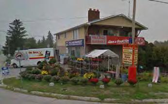
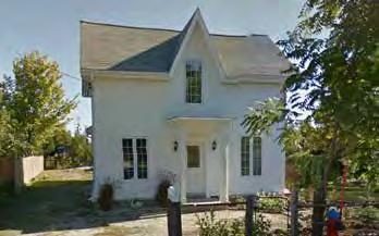
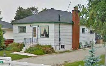
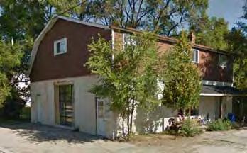
9 1.5 Existing Built Form The existing character of buildings within the local area can be categorized by the following; Range of architectural styles; Building heights; Materials; Setbacks; and Garage location. Range of Architectural Styles There is a variety of architectural styles and influences in the local area, from turn-of-the-century homes, post-war dwellings, bungalows from the 1960s to 1970s, and larger infill homes from the 1980s to 1990s. This variation is typical for a settlement with organic growth. Typical deep setbacks within Milton Heights The adjacent images demonstrate the range of building types in the area. Building Heights The images on the following page represent the range of building heights within the Milton Heights area. The building height ranges between one - two story with a number of 1.5 storey units throughout the villages. Materials There is a variety of materials used throughout the built form in the villages including wood, brick and weatherboard. This reflects the variation in architectural styles. This home uses locally sourced materials and has a striking roofline The older, brick buildings are typical of the area s heritage and proximity to the Niagara Escarpment and local kilns. Setbacks Buildings benefit from deep setbacks from the roads, which is evident on the aerial plan, on the following page. Setbacks decrease towards the intersection of Kelso Road, Tremaine Road and No. 3 Side Road; the village centre. This is an example of a historic home within the area. Garage Locations There are a variety of garage locations, including set back from the street, in line or behind the house building line, or generally located to the side of the residential unit. This home has a wide frontage, similar to the historic home above. Milton Heights Urban Design Guidelines 5


10 (EXISTING) TREMAINE ROAD MILTON HEIGHTS CRES. No. 3 SIDE ROAD Figure 4 - Aerial of Milton Heights, illustrating setbacks and garage locations 6 Revised - November 2015


11 1 Storey 1.5 Storeys 2 Storeys Existing Building Heights Milton Heights Urban Design Guidelines 7
12 1.6 Vision Vision Statement To create an attractive, memorable and safe community that respects the character and is inspired by the existing residential areas, such as the Milton Heights Community and Village of Peru, and is sensitive to its proximity to the Niagara Escarpment. The character and form of Milton Heights should protect and enhance the existing natural surrounding features as well as the wider environment, without encroaching on the surrounding protected areas such as the Niagara Escarpment, Kelso Conservation Area, the valley lands and parks included within the development. Considered design will maximize views into and through these areas, and will ensure that Milton Heights will offer easy access to outdoor spaces for active and passive recreation. Urban Design Objectives: Milton Heights will be an attractive and distinct community that residents can be proud of; Create a memorable community that promotes the distinct character of the area and draws inspiration from its industrial past; which includes the proximity to the Escarpment and its lime kilns; Use materials, such as limestone and built forms that reflect the proximity of the Escarpment and the adjacent rural area; Create a safe community whose design provides eyes on the streets, traffic calming, and neighbourhood interactions/sense of community; and Milton Heights Community will be made up of a number of individual neighbourhoods, each with their own character which reflect the existing character of the area and its history. Respect the existing environment Development shall respect the existing neighbourhoods by having lower density development adjacent to them increasing density as development is located further from the existing neighbourhooods; Development shall be sensitive to the Niagara Escarpment by having lower density development adjacent to the existing residential development closer to the escarpment, with increased landscaping and space between buildings; Development located further away from the Niagara Escarpment will be able to sensitively reference the historical industrial character of the area; A continuous, coherent walkable public realm composed of streets, sidewalks, open spaces and publicly accessible parts of private development, wherever possible, and shall all be linked to a trail/ pedestrian network; and Protect and enhance the existing natural environment (Niagara escarpment, valley lands etc.) while improving access to and maximize views to and through these areas. 8 Revised - November 2015
13 Roads Highway 401, existing Tremaine Road, Peru Road and the Canadian Pacific Railway will provide the site boundary; and New roads will be oriented to promote views to the Niagara Escarpment, green spaces (such as parks, storm ponds etc.) and to local features. Gateways There will be a primary gateway located at the intersection of New Tremaine Road and Highway 401 as identified in the Sherwood Survey Secondary Plan; Community Gateways will be located along the Gateway Street of New Tremaine Road. Architecture and landscaping details will be enhanced here to provide residents and visitors a sense of arrival into the neighbourhood; Neighbourhood Gateways are secondary gateways to provide a sense of arrival into residential and commercial areas. The treatment of neighbourhood gateways will be inspired by and at a smaller scale than primary gateways; New Tremaine Road will be developed as a Gateway Street; and The design for the New Tremaine bridge over Highway 401, will be subject to Ministry of Transport for Ontario and Town of Milton Standards. Mixed Use Community The Business Park, Commercial and Character Areas assist in creating a sustainable community which provides employment opportunities within walking distance of people s homes. Range of Housing Types There will be a variety of housing types to accommodate a mix of lifestyles. As per the Official Plan, the density distribution in the Milton Heights Neighbourhood may vary from a low 15 units per net hectare, near the Niagara Escarpment Plan Area, existing residential development and natural features, and a high of 40 units per net hectare abutting Provincial Freeways/Highways, Arterial Roads, Railway Corridors, employment lands to reflect the surrounding land uses. Open Space Valley Lands and environmentally sensitive areas shall be preserved; Village Squares should be located within walking distances to existing and proposed residential areas; The Community Park will be located East of New Tremaine Road and easily accessible to existing and future residents; Milton Heights Urban Design Guidelines 9
14 Through a participatory process, the Milton Heights Landowners Group has worked together with the existing residents to establish a strong community vision for the development of the new community; Extensive background review and focused discussions resulted in identifying a number of key issues including building heights and setbacks to address transition areas; and The principles and guidelines outlined in this document represent a balance among the participating stakeholders, and, have the general support of the community. Five public workshops were conducted, with councilors and local residents invited to participate. The process involved: Workshop #1 (May 2004) Gathered information and introduced preliminary design ideas of the landowners for discussion. Workshop #2 (April 2005) Residents and Landowners established principles of development, including road patterns, lot fabric, parks, open spaces, and amenities. Workshop #3 (May 2005) Created preliminary themes and concept designs for the neighbourhood based on principles established in Workshop #2. Workshop #4 (September 2005) Refined themes and concepts based on feedback. Workshop #5 (January 2005) Discussed planning and procedural issues. Goals & Principles from Workshop #2: Protect and sensitively integrating natural features; Create an interconnected parks and open space system; Respect the existing heritage of the community; Provide creative housing designs that complements the local character and forms gradual architectural transitions between existing and new development; Create a fully integrated community; Create a legible street patterns with a clear hierarchy; Create enhanced and pedestrian friendly streetscapes; and Create a unified community identity and vision for Milton Heights and The Village of Peru. Public meetings were also held to keep area residents and Town staff informed on the evolution of the plans. The extensive community consultation process was followed with comprehensive discussions with senior Town of Milton staff to affirm the community vision and establish the key planning principles to achieve it. Town Staff have established the key planning, urban design, engineering and park principles and have had considerable input into the creation of the community concept plan and its evolution to draft plans and site specific zoning by-laws. 10 Revised - November 2015
15 2.0 COMMUNITY STRUCTURE & PUBLIC REALM The structure of the Milton Heights community results from the combination of elements listed below; Land Use; Neighbourhood Character Areas; Building Heights; Road Network; Open Space network; and Trails and Pedestrian Movement Network. As required by the Official Plan, new development within the Milton Heights Neighbourhood shall be coordinated with existing or proposed development on the adjacent lands and within the sub-neighbourhood. Development shall reflect policies of the Official Plan and address such issues as compatibility of lane use and transition of density, lot sizes and housing type based on consideration of the proximity of new development to: The Niagara Escarpment Plan Area and natural heritage feature; Arterial Roads, employment lands, railways and provincial highways and employment areas; and The existing residential development with the principle overall objective of maintaining a significant degree of larger lot development adjacent to the Niagara Escarpment Plan Area. Milton Heights Urban Design Guidelines 11
16 2.1 Land Use Plan Milton Heights will have a range of land uses in order to create a sustainable, cohesive community, where the local population will have the opportunity to live and work. Development will be designed to be sympathetic to the surroundings and will reflect its unique setting adjacent to the Niagara Escarpment and the character of the existing residential communities. The community will include residential, a mixed use area, the business parks, a commercial block and areas of open space. Residential Uses The predominant land use within Milton Heights will be residential, which will be located in both the northern and southern halves of the community. To respect the surroundings there will be a range of development density. Low density development will include detached, semidetached and condominium laneway singles. The low density development will be located along the existing Tremaine Road and adjacent to the existing communities at Peru Road and No. 3 Side Road. The medium density residential will include On-Street Townhouses, which can include condominiums or detached, laneway townhouses and laneway decked townhouses, both of which may include condominiums. Condominium Laneway Homes may be located along the New Tremaine Road corridor, fronting on to Milton Heights Crescent, abutting Highway 401 and the interchange. Mixed Use Character Area This is located at the intersection of New Tremaine Road, No. 3 Side Road and along the No. 3 Side Road corridor. The mixed use area will include live/ work units with commercial uses at grade and medium density residential uses. Business Parks There are two business parks proposed within Milton Heights. The business park in the north is located adjacent to the 401 Highway and benefits from being highly visible and easily accessible from the highway. The business park in the south of Milton Heights adjacent to Peru Road will provide a transition between the employment uses east of Peru Road and residential uses to the west. Both locations assist with noise mitigation from the adjacent industrial uses. Additional noise mitigation measures will be provided as outlined in the noise report, including treatment to the built form, landforms and landscaping. Commercial Block The commercial focus is located at the north west and south-east corners of Tremaine and the No. 3 Side Road. Open Space Network Milton Heights has a strong, connected open space network which includes a range of open spaces and elements located throughout the community. The open space network includes preservation of existing environmentally sensitive areas, stormwater management ponds, village squares and community parks. 12 Revised - November 2015
17 ST. R STREET C STREET D THE KING S HIGHWAY No. 401 STREET A MILTON HEIGHTS CRESCENT STREET E STREET G STREET F STREET A STREET H STREET E STREET E SP No. 3 SIDE RD ST. O SIXTEEN MILE CREEK STREET D STREET C STREET I STREET P STRE ET Q STREET N STREET M EXISTING TREMAINE RD SP COMMUNITY PARK PERU RD SP PROPOSED ACCESS ROAD NEW TREMAINE RD CANADIAN PACIFIC RAILWAY SP STREET V STREET W STREET X STREET S STEELES AVE W STREET U SP STREET S SP Legend Existing Residential Detached Detached, Semis, and/or Townhouses Street Townhouses Condominium Dwellings Business Park Commercial Parkland Area and Open Space Greenland Areas Drainage Corridor Buffers and Walkways Mixed Use / Character Area Stormwater Ponds Figure 5 - Land Use Plan for Milton Heights N Milton Heights Urban Design Guidelines 13
18 2.2 Neighbourhood Character Areas To distinguish and celebrate the unique character and history of Milton Heights, the development areas have been divided into 5 Character Areas that are separated by the valley and New Tremaine Road. The character areas to the north of the community should draw inspiration from the region s lime kilns history and the existing industry while those to the south should draw emphasis from the former brickworks. Milton Heights North The north western area, Milton Heights North, should be a residential community whose design and character provides a sensitive and complimentary transition from the Niagara Escarpment in the west to the industrial land to its east. The Community s western edge should emphasize a lower density which reflects the local character of the existing residential areas. Typically, this should include detached units with larger spaces between houses, smaller units, retaining the existing vegetation where possible and enhanced landscaping. Limestone should be used as the primary building material, to reference the area s heritage. On the eastern side of Milton Heights North buildings will have a more urban and industrial feel to create a transition into the adjacent business park to the east. Development here will be of a higher density, with opportunities for contemporary designs and a more compact layout. Milton Heights South New development within the Milton Heights South character area should be inspired by the area s existing built form; which includes existing residential units and the area s former brickwork industries. New Peru The New Peru character area should form a new community that draws inspiration from the brick making industrial past of this area. The architectural style of the brick workers cottages on Steeles Avenue should be the inspiration for new detached residential development at this location. The street townhouses within the character area provide the opportunity for more contemporary designs to be implemented into the architecture. Old Peru Residential development along Peru Road in Old Peru will also draw on the character of the existing residential and the brick workers cottage with simple architecture and materials. New development on the western side of the character area will draw inspiration from the existing residential architecture as well as provide opportunity for contemporary design to be implemented. Refer to Figure 6 - Milton Heights Character Areas Plan. This character will reflect a distinct community that reflects the industrial past of this area. Milton Heights North Business Park At the Milton Heights North Business Park the built form should be industrial in character to reflect their commercial uses. Buildings fronting onto New Tremaine Road should frame the road and create a sense of enclosure, as well as forming a gateway into Milton Heights. 14 Revised - November 2015
19 ST. R STREET C STREET D STREET A MILTON HEIGHTS NORTH MILTON HEIGHTS CRESCENT STREET E STREET G STREET F STREET A STREET H STREET E STREET E THE KING S HIGHWAY No. 401 MILTON HEIGHTS NORTH BUSINESS PARK No. 3 SIDE RD SIXTEEN MILE CREEK MILTON HEIGHTS SOUTH STREET D STREET C STREET I STRE ET Q STREET P ST. O STREET N NEW PERU STREET M EXISTING TREMAINE RD PERU RD CANADIAN PACIFIC RAILWAY PROPOSED ACCESS ROAD NEW TREMAINE RD STREET V STREET W STREET X STREET U OLD PERU STREET S STREET S STEELES AVE W N Figure 6 - Milton Heights Character Areas Plan Milton Heights Urban Design Guidelines 15
20 2.3 Building Heights Proposed building heights should be contextually appropriate and respect the height of the existing buildings and provide a transition between the existing and new development areas. In order achieve appropriate transitions to the existing residential communities, the Niagara Escarpment Plan Area and natural heritage features, the maximum height and massing for dwellings have been limited in different areas. Milton Heights North New built form of Milton Heights North will be located adjacent to the existing Tremaine Road and behind existing residential north of No. 3 Side Road. Condominiums surrounding the Northern Village Square will be a maximum of 1-2 storeys (9.5m) in order to be complimentary to the existing development to the west, as well as providing a complimentary buffer to the surrounding proposed increased density. The majority of the proposed detached and street townhouse residential development in to the north and east of the Northern Village Square will be a maximum 2 storeys (10.0m). The condominium development block abutting highway 401 may have up to 3 storey development for those dwellings directly abutting the open space adjacent to Highway 401. Development between the Northern Village Square and the abutting condo development will transition in height from 9.5m to 12.5m to provide a gradient in height through the character area. New Peru The new built form within New Peru, located to the East of New Tremaine Road, will be a majority of Street Townhouses and a small number of Detached Dwellings. The Street Townhouses, that abut proposed business and commercial land uses, will make up the majority of new infrastructure and will be a maximum of 2½-3 storeys (12.5m) in height. The Detached Dwellings, located to the north of the greenbelt buffer and west of existing residential, will be a maximum of 2-2½ storeys (11.0m) to act as a transition between the open space and new development. Old Peru Built form of Old Peru both respects the existing residential along Peru Road and allows for larger development to occur behind the Greenbelt. The development along Peru Road consists of new development that will be a maximum of 1-2 storey (9.0m), keeping consistent with the existing infrastructure along the road. The development between the Greenbelt and the Railway tracks consists of detached and townhouse dwellings that will be a maximum of 2-2½ storeys (11.0m) to the north west and condominiums that will be a maximum of 2½-3 storeys (12.5m) along the south east of the development. Building heights for these character areas can be seen in Figure 7: Building Height Demonstration Plan. Heights are subject to zoning by-law standards. 16 Revised - November 2015
21 ST. R STREET C STREET D THE KING S HIGHWAY No. 401 STREET A MILTON HEIGHTS CRESCENT STREET E STREET G STREET F STREET A STREET H STREET E STREET E No. 3 SIDE RD ST. O SIXTEEN MILE CREEK STREET D STREET C STREET I STREET P STRE ET Q STREET N STREET M EXISTING TREMAINE RD PERU RD CANADIAN PACIFIC RAILWAY PROPOSED ACCESS ROAD NEW TREMAINE RD STREET V STREET W STREET X STREET S STREET U STREET S Legend 1-2 Storey - 9 Metres 1-2 Storey Metres 2 Storey - 10 Metres 2-2½ Storey - 10 Metres 2-2½ Storey- 11 Metres 2½ - 3 Storey Metres STEELES AVE W N Figure 7 - Permitted Maximum Building Height Milton Heights Urban Design Guidelines 17
22 2.4 Road Network Street hierarchy, alignments and block development patterns strongly influence the overall community structure and physical form of the community. The proposed road network at Milton Heights is informed by the existing road hierarchy which includes; Highway 401; Tremaine Road; Peru Road; Milton Heights Crescent; No. 3 Side Road; and Steeles Avenue West. Existing Road Pattern The site is bounded by Highway 401 to the north, Peru Road to the East, Steeles Avenue West to the south and Tremaine Road to the west. No. 3 Side Road transects the northern half of the community. This existing network will help create a strong movement framework in and around the community. Proposed Road Pattern To support the comprehensive and cohesive development of Milton Heights, the proposed New Tremaine Road will provide a direct north-south movement route within Milton Heights. This is a major arterial Road and Gateway Street and will act as the main movement corridor within the community. The central alignment of New Tremaine Road ensures that all of Milton Heights is accessible and connected. The goals and objectives of the alignment of the Milton Heights road network includes: Create a well-connected movement network that promotes both vehicular and pedestrian connectivity within and around the community. The movement network will be legible with a clear hierarchy which provides a range of movement options throughout the neighbourhoods; Support the Town s Official Plan and Secondary Plans vision for Tremaine, Peru and No. 3 Side Road as Character Roads. Further description of character roads is provided in the adjacent plan and in Section Proposed Road Hierarchy The existing and proposed roads are categorized below. Further information on the various road classification can be found in Section 2.14 where further details are provided. Highway Highway 401 Major Arterial Road / Gateway Street New Tremaine Road Character Road Tremaine Road Part of No. 3 Side Road Southern Portion of Peru Road Collector Road Third Side Road Northern portion of Peru Road Local Roads Within residential blocks Condominium Roads Located in the Condominium blocks in the north of the site Condominium Laneways Located in the Condominium blocks in the north of the site Align the road network to maximize, maintain and enhance views to the Niagara Escarpment, the Kelso Conservation Area and the Sixteen Mile Creek; and 18 Revised - November 2015
23 ST. R STREET C STREET D THE KING S HIGHWAY No. 401 STREET A MILTON HEIGHTS CRESCENT STREET E STREET G STREET F STREET A STREET H STREET E STREET E No. 3 SIDE RD ST. O SIXTEEN MILE CREEK STREET D STREET C STREET I STREET P STRE ET Q STREET N STREET M EXISTING TREMAINE RD PERU RD CANADIAN PACIFIC RAILWAY PROPOSED ACCESS ROAD NEW TREMAINE RD STREET V STREET W STREET X STREET S STEELES AVE W STREET U STREET S Legend Provincial Freeway Major Arterial Road Collector Road Local Road Proposed Local Roads Proposed Neighbourhood Connector Canadian Pacific Railway Planned 401 Interchange Gateway Street Character Road Future Cul-de-Sac Figure 8 - Road Network Plan for Milton Heights N Milton Heights Urban Design Guidelines 19
2.5 Roads. Loading and service areas adjacent to Highway 401 should be screened through architectural walls and/or landscape buffer planting.
 N HIGHWAY OFF RAMP 2.5 Roads A legible road network with a clear hierarchy will help create a connected community, both within and surrounding the Milton Heights. The following section outlines the proposed
Urban Design Brief Proposed Residential Development 5219 Upper Middle Road City of Burlington
 Urban Design Brief Proposed Residential Development 5219 Upper Middle Road City of Burlington Prepared by Weston Consulting Prepared for BLOOMFIELD DEVELOPMENT INC. Date: March 2017 Table of Contents 1.
Derry Green Corporate Business Park
 Town of Milton Derry Green Corporate Business Park Urban Design Guidelines BMI/Pace - June 2010 Draft 3 Prepared by: Brook McIlroy Planning + Urban Design / Pace Architects Suite 300-51 Camden Street Toronto,
Complete Neighbourhood Guidelines Review Tool
 Complete Neighbourhood Guidelines Review Tool Prepared By: City of Regina Planning Department October 2014 Page 1 of 14 Community Development Review Checklist for Secondary Plans and Concept Plans The
C.10 Boyne Survey Secondary Plan
 C.10 Boyne Survey Secondary Plan SECONDARY PLAN July 2017 C.10 BOYNE SURVEY SECONDARY PLAN C.10.1 C.10.1.1 GENERAL PURPOSE The purpose of the Boyne Survey Secondary Plan is to establish a more detailed
AMENDMENT NO. 30 TO THE OFFICIAL PLAN OF THE TOWN OF MILTON
 AMENDMENT NO. 30 TO THE OFFICIAL PLAN OF THE TOWN OF MILTON Subject: Boyne Survey Secondary Plan and Related Official Plan Amendments The following text and schedules constitute Amendment No. 30 to the
CONTENTS 8.0 LAND USE 8.1 GENERAL LAND USE 8.2 RESIDENTIAL 8.3 MIXED USE 8.4 COMMERCIAL 8.5 EMPLOYMENT LANDS
 8-2 Land Use 8.0 LAND USE CONTENTS 8.1 GENERAL LAND USE 8.1.1 Uses provided for in all Land Use Designations 8.1.2 Uses prohibited in Hazardous Lands, Hazardous Sites and Special Policy Areas 8.1.3 Uses
URBAN DESIGN BRIEF. 2136&2148 Trafalgar Road. Town of Oakville
 URBAN DESIGN BRIEF 2136&2148 Trafalgar Road Town of Oakville Prepared By: METROPOLITAN CONSULTING INC For 2500674 Ontario Inc November 2016 TABLE OF CONTENTS Page No. 1.0 Introduction/Description of Subject
Report to: Development Services Committee Report Date: April 24, 2017
 SUBJECT: Cornell Rouge National Urban Park Gateway - Report on Design Charrette and Next Steps PREPARED BY: Lilli Duoba, MES, MCIP, RPP, Manager, Natural Heritage (ext. 7925) REVIEWED BY: Marg Wouters,
DRAFT Northeast Quadrant of Kipling Avenue and Highway 7 DRAFT AUGUST 29, Goals Land Use. The goals of this Plan are to:
 AUGUST 29, 2017 12.15 Northeast Quadrant of Kipling Avenue and Highway 7 12.15.1 Goals 12.15.2 Land Use The goals of this Plan are to: 12.15.2.1 General Provisions: a) Ensure the development of a compact
URBAN DESIGN BRIEF URBAN DESIGN BRIEF 721 FRANKLIN BLVD, CAMBRIDGE August 2018
 URBAN DESIGN BRIEF URBAN DESIGN BRIEF 721 FRANKLIN BLVD, CAMBRIDGE August 2018 DESIGN BRIEF CONTENTS PART A 1.0 INTRODUCTION 2.0 DESCRIPTION & ANALYSIS OF SITE CONTEXT 3.0 DESIGN CONSTRAINTS AND OPPORTUNITIES
MAYFIELD WEST SECONDARY PLAN PHASE 2
 MAYFIELD WEST SECONDARY PLAN PHASE 2 Public Open House #3 February 25, 2010 Draft Preferred Land Use Scenario TOWN OF CALEDON PLANNING & DEVELOPMENT DEPARTMENT Open House Agenda TOWN OF CALEDON 1. Welcome
East Bayshore Road Neighbourhood
 East Bayshore Road Neighbourhood Northridge Property Management Urban Design Brief 3195 East Bayshore Road City of Owen Sound January 2016 East Bayshore Road Neighbourhood Northridge Property Management
New-Cast Mixed-use Development Proposal King Street West, Newcastle, Ontario
 URBAN DESIGN BRIEF New-Cast Mixed-use Development Proposal King Street West, Newcastle, Ontario TABLE OF CONTENTS: 1.0 Executive Summary 2.0 Creating Vibrant and Sustainable Urban Places: Excerpts from
URBAN DESIGN BRIEF 181 Burloak Drive, Oakville
 URBAN DESIGN BRIEF 181 Burloak Drive, Oakville February 2017 Our File: 1730B 230-7050 WESTON ROAD / WOODBRIDGE / ONTARIO / L4L 8G7 / T: 905 761 5588/ F: 905 761 5589/WWW.MHBCPLAN.COM TABLE OF CONTENTS
Mark-up of the effect of the proposed Bronte Village Growth Area OPA No.18 on the text of section 24, Bronte Village, of the Livable Oakville Plan
 Mark-up of the effect of the proposed Bronte Village Growth Area OPA No.18 on the text of section 24, Bronte Village, of the Livable Oakville Plan Notes: This document is provided for information purposes
II. SINGLE FAMILY RESIDENTIAL
 II. SINGLE FAMILY RESIDENTIAL Castle Rock is made up of numerous individually built houses and subdivision tracts that have been developed during the past century. Some of the tracts are diverse in architectural
Bressa Developments Limited. Planning Justification Report. Revised Draft Plan of Subdivision and Zoning By-Law Amendment
 Bressa Developments Limited Revised Draft Plan of Subdivision and Zoning By-Law Amendment Planning Justification Report Part of Lots 7 & 8 Concession 1, North of Dundas Street Town of Oakville September,
PORT WHITBY COMMUNITY
 PORT WHITBY COMMUNITY SECONDARY PLAN UPDATE COMMUNITY IMPROVEMENT PLAN URBAN DESIGN GUIDELINES September 2015 DRAFT PROPOSED AMENDMENT NUMBER # to the Whitby Official Plan PURPOSE: The intent of this Amendment
FORMER CANADIAN FORCES BASE (CFB) ROCKCLIFFE SECONDARY PLAN. Official Plan Amendment XX to the Official Plan for the City of Ottawa
 ROCKCLIFFE SECONDARY PLAN. Official Plan Amendment XX to the Official Plan for the City of Ottawa") FORMER CANADIAN FORCES BASE (CFB) ROCKCLIFFE SECONDARY PLAN Official Plan Amendment XX to the Official Plan for the City of Ottawa 1 INDEX THE STATEMENT OF COMPONENTS PART A THE PREAMBLE PAGE Purpose...
FORMER CANADIAN FORCES BASE (CFB) ROCKCLIFFE SECONDARY PLAN Official Plan Amendment XX to the Official Plan for the City of Ottawa 1 INDEX THE STATEMENT OF COMPONENTS PART A THE PREAMBLE PAGE Purpose...
Further input invited as Colchester Growth Strategy nears final phase
 IUE 3 / NOVEMBER 2015 Further input invited as Colchester Growth trategy nears final phase trathcona County is seeking public feedback as it enters the final phase of work on a Growth Management trategy
THE CORPORATION OF THE TOWN OF OAKVILLE BY-LAW NUMBER
 THE CORPORATION OF THE TOWN OF OAKVILLE BY-LAW NUMBER 20012-08530 A by-law to adopt an amendment to the Official Plan of the Oakville Planning Area (Official Plan Amendment 198) Land North of Dundas Street.
AGINCOURT SECONDARY PLAN
 1 AGINCOURT SECONDARY PLAN 1. AGINCOURT SECONDARY PLAN The following policies and principles apply to the area herein referred to as Agincourt, as outlined on Map 1-1. 1. GENERAL POLICIES 1.1 This Secondary
Background Summary Report
 Background Summary Report May 2014 Submitted by Macaulay Shiomi Howson Ltd. In association with AMEC MMM Group Brook McIlroy Inc. Hemson Consulting Ltd. Table of Contents 1. Introduction... 1 2. Why is
4.0 Design Guidelines For The Village Centre. South fields Community Architectural Design Guidelines Town of Caledon
 4.0 Design Guidelines For The Village Centre 4.0 Design Guidelines for the Village Centre The Village Centre is the focal point of the entire South Fields Community and is designed as a traditional commercial
Agenda. 7 Wright Crescent Urban Design Study. Public Meeting and Urban Design Workshop. 1 INTRODUCTION AND BACKGROUND (City of Kingston)
") Urban Design Study Public Meeting and Urban Design Workshop October 02, 2013 Agenda 1 INTRODUCTION AND BACKGROUND (City of Kingston) 2 URBAN DESIGN STUDY PRESENTATION (Antonio Gomez-Palacio, DIALOG) 3
Urban Design Study Public Meeting and Urban Design Workshop October 02, 2013 Agenda 1 INTRODUCTION AND BACKGROUND (City of Kingston) 2 URBAN DESIGN STUDY PRESENTATION (Antonio Gomez-Palacio, DIALOG) 3
URBAN DESIGN BRIEF. Saginaw Subdivision 124 SAGINAW PARKWAY, CAMBRIDGE OCTOBER 2015 OUR FILE 1422A
 URBAN DESIGN BRIEF Saginaw Subdivision 124 SAGINAW PARKWAY, CAMBRIDGE OCTOBER 2015 OUR FILE 1422A Contents 1.0 INTRODUCTION AND SITE DESCRIPTION... 1 2.0 MUNICIPAL DESIGN DIRECTION... 7 3.0 MASTER CONCEPT
DAVENPORT VILLAGE SECONDARY PLAN
 27 DAVENPORT VILLAGE SECONDARY PLAN 27. DAVENPORT VILLAGE SECONDARY PLAN 1. VISION FOR THE DAVENPORT VILLAGE SECONDARY PLAN Davenport Village, municipally known as 830, 940, 980 and 1100 Lansdowne Avenue,
Urban Design Brief. Watson Parkway North & Watson Road North Guelph, Ontario. Prepared by Coletara Development
 Urban Design Brief Watson Parkway North & Watson Road North Guelph, Ontario Prepared by Coletara Development December, 2013 Urban Design Brief, Coletara Development 1 Introduction This Urban Design Brief
Leonard s Beach Secondary Plan (Alcona North) Official Plan Amendment
 Official Plan Amendment") Leonard s Beach Secondary Plan (Alcona North) Official Plan Amendment Public Meeting Presentation August 14, 2013 Note: This document is for presentation purposes only. Please see Staff Report DSR-135-13
Leonard s Beach Secondary Plan (Alcona North) Official Plan Amendment Public Meeting Presentation August 14, 2013 Note: This document is for presentation purposes only. Please see Staff Report DSR-135-13
YONGE STEELES CORRIDOR SECONDARY PLAN. Young + Wright / IBI Group Architects Dillon Consulting Ltd. GHK International (Canada) Ltd.
 Ltd.") PART A: PREAMBLE 1.0 PURPOSE The purpose of this Secondary Plan is to provide a development framework for intensification of the Yonge/ Steeles corridor including the north side of Steeles Avenue West
PART A: PREAMBLE 1.0 PURPOSE The purpose of this Secondary Plan is to provide a development framework for intensification of the Yonge/ Steeles corridor including the north side of Steeles Avenue West
URBAN DESIGN BRIEF Gordon Street City of Guelph. Prepared on behalf of Ontario Inc. March 25, Project No. 1507
 URBAN DESIGN BRIEF 1131 Gordon Street City of Guelph Prepared on behalf of 1876698 Ontario Inc. March 25, 2016 Project No. 1507 423 Woolwich Street, Suite 201, Guelph, Ontario, N1H 3X3 Phone (519) 836-7526
The West Vaughan Employment Area Secondary Plan Policies
 Part 2: The West Vaughan Employment Area Secondary Plan Policies 2.1 General Policies It is the policy of Council: 2.1.1. That the West Vaughan Employment Area (the WVEA), identified on Schedule 1, will
HURON COMMUNITY PLAN
 CITY OF KITCHENER DEPARTMENT OF DEVELOPMENT AND TECHNICAL SERVICES PD 94/7 HURON COMMUNITY PLAN Recommended by Planning and Economic Development Committee: October 31, 1994 Adopted by Kitchener City Council:
Clairtrell Area Context Plan
 Clairtrell Area Context Plan March 2005 Urban Development Services City Planning Contents 1. Introduction... 4 2. Development Structure... 6 2.1 Streets... 7 2.1.1 Sheppard Avenue and Bayview Avenue...
Planning Justification Report. Milton Meadows Properties Ltd. Milton Meadows South IN SUPPORT OF ZONING BY-LAW AMENDMENT & DRAFT PLAN OF SUBDIVISION
 Planning Justification Report Milton Meadows Properties Ltd. Milton Meadows South IN SUPPORT OF ZONING BY-LAW AMENDMENT & DRAFT PLAN OF SUBDIVISION For Part of Lot 3, Concession 1 Town of Milton HUMPHRIES
Regency Developments. Urban Design Brief. Holyrood DC2 Rezoning
 Regency Developments Urban Design Brief Holyrood DC2 Rezoning Stantec Consulting Ltd. 7-31-2017 1. Overview Regency Developments intends to rezone the lands located at 8510 and 8511 93 Avenue, within the
McCowan Precinct Plan Study Background & Deliverables
 1 DRAFT & WITHOUT PREJUDICE McCowan Precinct Plan Study Background & Deliverables In September, 2011, City Planning (Scarborough District) began a study of an area within the Scarborough Centre, identified
13 THORNHILL YONGE STREET STUDY IMPLEMENTATION CITY OF VAUGHAN OPA 669 AND TOWN OF MARKHAM OPA 154
 13 THORNHILL YONGE STREET STUDY IMPLEMENTATION CITY OF VAUGHAN OPA 669 AND TOWN OF MARKHAM OPA 154 The Planning and Economic Development Committee recommends the adoption of the recommendations contained
Midtown Oakville will be a vibrant, transit-supportive, mixed use urban community and employment area.
 Livable Oakville Part E: Growth Areas, Special Policy Areas and Exceptions 20. MIDTOWN OAKVILLE 20.1 Goal The interchange of Trafalgar Road and the QEW and the Oakville GO Station are major entry points
Brampton. Secondary Plan. Review. Bram West. A New Direction in Planning & Public Consultation
 Brampton Bram West Secondary Plan Review A New Direction in Planning & Public Consultation Introduction The Bram West Secondary Plan Review offers an important opportunity for the community to define a
TOWN OF COBOURG EAST COMMUNITY SECONDARY PLAN AREA
 TOWN OF COBOURG EAST COMMUNITY SECONDARY PLAN AREA URBAN DESIGN GUIDELINES DRAFT Brook McIlroy Inc Planning + Urban Design November, 2004 Table of Contents 1.0 INTRODUCTION 1.1 The Urban Design Approach
Courtice Main Street Study Community Vision Workshop PLANNING SERVICES DEPARTMENT
 Courtice Main Street Study Community Vision Workshop PLANNING SERVICES DEPARTMENT July 22, 2009 Tonight s Meeting 7:00 pm Introduction David Crome, Director of Planning 7:05 Presentation Stasia Bogdan,
8 Oak Street - Official Plan and Zoning By-law Amendment Application - Preliminary Report
 STAFF REPORT ACTION REQUIRED 8 Oak Street - Official Plan and Zoning By-law Amendment Application - Preliminary Report Date: March 17, 2014 To: From: Wards: Reference Number: Planning and Growth Management
11.4 Highway 400 North Employment Lands Secondary Plan APPROVED BY THE ONTARIO MUNICIPAL BOARD ON NOVEMBER 21, 2011
 11.4 Highway 400 North Employment Lands Secondary Plan APPROVED BY THE ONTARIO MUNICIPAL BOARD ON NOVEMBER 21, 2011 11.4.1 General 11.4.1.1. as approved by the Ontario Municipal Board on November 21, 2011,
URBAN DESIGN STUDY and GUIDELINES
 ALTON CENTRAL EAST COMMUNITY CITY OF BURLINGTON URBAN DESIGN STUDY and GUIDELINES Prepared by NAK DESIGN GROUP March 2004 ALTON CENTRAL EAST CITY OF BURLINGTON TABLE OF CONTENTS PART I - Alton Central
Clair-Maltby Community visioning
 Clair-Maltby Community visioning workshop #1 Summary April 27th, 2017 Table of Contents INTRODUCTIon 1 PURPOSE 1 CONSULTATION STRUCTURE 2 PARTICIPANT FEEDBACK 3 VISIONING EXERCISE 8 ONLINE SURVEY RESULTS
Westwind Developments Ltd. PIONEER LANDS AREA STRUCTURE PLAN - PROPOSED AMENDMENT
 FEBRUARY 2013 TABLE OF CONTENTS 1.0 BACKGROUND... 1 1.1 Amendment... 1 2.0 LOCATION & CONTEXT... 2 2.1 Land Ownership... 2 3.0 POLICY CONTEXT... 3 3.1 Municipal Development Plan... 3 3.2 Capital Region
DOWNTOWN GEORGETOWN PLANNING STUDY
 DOWNTOWN GEORGETOWN PLANNING STUDY Community Workshop #3 Thursday, May 4, 08 The Planning Partnership OVERVIEW OF STUDY, PROCESS & MILESTONES We are here PURPOSE OF THE STUDY To develop a clear vision
280 Manse Road - Official Plan Amendment, Zoning Amendment, Draft Plan of Subdivision Applications - Preliminary Report
 STAFF REPORT ACTION REQUIRED 280 Manse Road - Official Plan Amendment, Zoning Amendment, Draft Plan of Subdivision Applications - Preliminary Report Date: March 11, 2014 To: From: Wards: Reference Number:
*** DRAFT 2 FOR PUBLIC REVIEW ***
 6.7 The area is generally bounded by the Red Hill Valley Parkway to the west, Lake Avenue to the east, the Queen Elizabeth Way (QEW) to the north, and by the properties just south of Queenston Road to
North Oakville East Parks Facilities Distribution Plan. November, 2009
 North Oakville East November, 2009 POLICY CONTEXT 1) Purpose a) The purpose of this document is to be a guide for the location, configuration, design and development of the parks system for the North Oakville
Table 8-4: Road Classification Local Roads, second table, of Chapter 8 Create a Multi-Modal City, be amended by adding the following:
 1 Port Street East Official Plan Amendment APPENDIX 3 Amendments to Mississauga Official Plan Table 8-4: Road Classification Local Roads, second table, of Chapter 8 Create a Multi-Modal City, be amended
Attachment 1 TOWN OF NEW TECUMSETH. Manual for the Preparation of an Urban Design Report
 Attachment 1 TOWN OF NEW TECUMSETH Manual for the Preparation of an Urban Design Report July 2010 TABLE OF CONTENTS Background, Policy Framework and the Preparation of Urban Design Reports 1. Introduction
ELMVALE ACRES SHOPPING CENTRE MASTER PLAN
 ELMVALE ACRES SHOPPING CENTRE MASTER PLAN Contents 1.0 INTRODUCTION... 2 2.0 LOCATION... 2 3.0 EXISTING CONTEXT... 2 4.0 VISION & GUIDING PRINCIPLES... 2 5.0 LAND USE AND BUILT FORM... 4 5.1 St. Laurent
Official Plan Review: Draft Built Form Policies
 PG.30.1 REPORT FOR ACTION Official Plan Review: Draft Built Form Policies Date: May 15, 2018 To: Planning and Growth Management Committee From: Chief Planner and Executive Director, City Planning Division
URBAN DESIGN BRIEF New Street Burlington, ON
 3225-3237 New Street Burlington, ON MARCH 2017 Prepared for: Royal Living Development Group Inc. Prepared by: adesso design inc. 218 Locke Street South, 2nd Floor Hamilton, ON L8P 4B4 t. 905.526.8876 3225-3237
Draft Urban Hamilton Official Plan. Amendment No. XX
 1 of 75 The following text, together with: Draft Appendix A Appendix B Volume 1, Schedule E-1 Urban Land Use Designations Appendix C Volume 1, Appendix A Parks Classification Map Appendix D Volume 1, Appendix
ARTICLE 6: Special and Planned Development Districts
 ARTICLE 6: Special and Planned Development Districts 6-10 Traditional Neighborhood Development (TND) District 6-10.10 Purpose and Intent The Traditional Neighborhood Development (TND) District provides
MOUNT PLEASANT SECONDARY PLAN & VILLAGE BLOCK PLAN. Wednesday, March 5, 2008 Informal Public Open House
 MOUNT PLEASANT SECONDARY PLAN & VILLAGE BLOCK PLAN Wednesday, March 5, 2008 Informal Public Open House 1. Welcome & Introductions 2. Highlights of Provincial Growth Plan 3. Overview and Status Update -
MAYFIELD WEST SECONDARY PLAN PHASE 2
 MAYFIELD WEST SECONDARY PLAN PHASE 2 Council Information Workshop February 16, 2010 Draft Preferred Land Use Plan TOWN OF CALEDON PLANNING & DEVELOPMENT DEPARTMENT Workshop Agenda TOWN OF CALEDON 1. Welcome
GUIDELINES BAYVIEW INSTITUTIONS CONTEXT PLAN LOCATION PLAN COMPONENTS URBAN DESIGN GUIDELINES
 Development in the Bayview Sunnybrook area will be consistent with the following urban design guidelines. They provide a framework for development in the area and are to be read in conjunction with the
THE CITY OF VAUGHAN BY-LAW BY-LAW NUMBER A By-law to adopt Amendment Number 1 to the Official Plan of the Vaughan Planning Area.
 THE CITY OF VAUGHAN BY-LAW BY-LAW NUMBER 015-2014 A By-law to adopt Amendment Number 1 to the Official Plan of the Vaughan Planning Area. NOW THEREFORE the Council of the Corporation of the City of Vaughan
Highland Village Green Design Guidelines
 Highland Village Green Design Guidelines Publishing Information Title Highland Village Green Design Guidelins Author The City of Calgary Status DRAFT - Proposed document subject to changes Additional Copies
CREATE A VIBRANT MIXED-USE COMMUNITY
 CREATE A VIBRANT MIXED-USE COMMUNITY Land Use Public Realm Plan Built Form Heritage Tell us what you think! Place a sticky note here or leave us a comment form LAND USE The land use framework of this Secondary
Tremaine Dundas Secondary Plan (Draft May 2017)
") PB-52-17 Appendix A Tremaine Dundas Secondary Plan (Draft May 2017) Page 2 Tremaine Dundas Secondary Plan (Draft May 2017) This page has been left blank intentionally Page 3 Tremaine Dundas Secondary Plan
PB-52-17 Appendix A Tremaine Dundas Secondary Plan (Draft May 2017) Page 2 Tremaine Dundas Secondary Plan (Draft May 2017) This page has been left blank intentionally Page 3 Tremaine Dundas Secondary Plan
The lands identified as Residential Areas on Schedule A1, Urban Structure, represent the areas that provide for stable residential communities.
 Livable Oakville Part D: Land Use Designations and Policies 11. RESIDENTIAL 11.1 General The lands identified as Residential Areas on Schedule A1, Urban Structure, represent the areas that provide for
hermitage town center
 hermitage town center A Community Vision prepared by Strada for The City of Hermitage and The Mercer County Regional Planning Commission January 2007 table of contents introduction 3 design principles
Colchester Northern Gateway Master Plan Vision Review Draft. July 2016
 Colchester Northern Gateway Master Plan Vision Review Draft July 2016 Contents Introduction 4 Context 8 Purpose of the Report 8 Strategic Position 9 Overview of the Process 11 2012 Master Plan Vision 12
FRUITVALE TRANSIT VILLAGE (Phase 2) Residential Project
 Residential Project") FRUITVALE TRANSIT VILLAGE (Phase 2) Residential Project DEVELOPER: SIGNATURE PROPERTIES ARCHITECT: HKIT ARCHITECTS April 23, 2010 TABLE OF CONTENTS 3 Vision 4 Description of Site 5 Guiding Concepts 6
FRUITVALE TRANSIT VILLAGE (Phase 2) Residential Project DEVELOPER: SIGNATURE PROPERTIES ARCHITECT: HKIT ARCHITECTS April 23, 2010 TABLE OF CONTENTS 3 Vision 4 Description of Site 5 Guiding Concepts 6
QUEEN-RIVER SECONDARY PLAN
 34 QUEEN-RIVER SECONDARY PLAN 34. QUEEN RIVER SECONDARY PLAN 1. INTRODUCTION The Queen-River area is approximately 6.4 hectares and is located at the eastern edge of the Downtown as shown on Map 34-1.
Urban Design Brief to 1557 Gordon Street & 34 Lowes Road West
 Urban Design Brief 1533 to 1557 Gordon Street & 34 Lowes Road West Reid s Heritage Homes Ltd. & 883928 Ontario Ltd. and RHH Property Management Ltd. City of Guelph Zoning By-law Amendment November 2017
Welcome. Walk Around. Talk to Us. Write Down Your Comments
 Welcome This is an information meeting introducing the applications for proposed redevelopment of the Yorkdale Shopping Centre site at 3401 Dufferin Street and 1 Yorkdale Road over the next 20+ years,
Official Plan Review
 Official Plan Review Summary Report - The Built Environment August 2014 Part 1: Introduction Planning for a healthy, prosperous and sustainable community is an important goal for our municipality. From
Chapter 2: OUTLINE PLANNING APPLICATION PROPOSALS. A New Garden Neighbourhood Matford Barton 17
 Chapter 2: OUTLINE PLANNING APPLICATION PROPOSALS A New Garden Neighbourhood Matford Barton 17 2.1. SUMMARY AND STATUS OF THE PROPOSALS 2.1.1. The parameter plans and associated wording in this chapter
The protection of the agricultural resources of the Province;
 PART II INTRODUCTION An Official Plan is a policy document, which is intended to serve as the basis for making land use decisions and managing change in any municipality in Ontario. According to the Planning
ONTARIO MUNICIPAL BOARD
 PL 120483 ONTARIO MUNICIPAL BOARD Applicant/Appellant: 2124123 Ontario Limited Subject: OPA, Rezoning and Draft Plan of Subdivision Municipal Address: 3940 Highway 7 East Municipality: City of Markham
Queensborough Eastern Neighbourhood Node. Community Open House
 Queensborough Eastern Community Open House The Vision The Queensborough Eastern will become the heart of eastern Queensborough. Through a sensitive mix of viable commercial and residential areas, the neighbourhood
2900 Steeles Avenue East at Don Mills Road in the Town of Markham
 STAFF REPORT INFORMATION ONLY 2900 Steeles Avenue East at Don Mills Road in the Town of Markham Date: January 23, 2008 To: From: Wards: Reference Number: North York Community Council Director, Community
5 TOWN OF MARKHAM OFFICIAL PLAN AMENDMENT NO. 144 MILLIKEN MAIN STREET SECONDARY PLAN
 5 TOWN OF MARKHAM OFFICIAL PLAN AMENDMENT NO. 144 MILLIKEN MAIN STREET SECONDARY PLAN The Planning and Economic Development Committee recommends the following: 1. The communication from Brendan O Callaghan,
[PLANNING RATIONALE] For Site Plan Control and Lifting of Holding Zone By-Law 101 Champagne Avenue. May 23, 2014
![[PLANNING RATIONALE] For Site Plan Control and Lifting of Holding Zone By-Law 101 Champagne Avenue. May 23, 2014](/thumbs/75/71599615.jpg "[PLANNING RATIONALE] For Site Plan Control and Lifting of Holding Zone By-Law 101 Champagne Avenue. May 23, 2014") [PLANNING RATIONALE] For Site Plan Control and Lifting of Holding Zone By-Law 101 Champagne Avenue May 23, 2014 Contents 1.0 Introduction... 2 2.0 Site Context... 2 2.1 Adjacent Uses... 2 Figure 1: Site
[PLANNING RATIONALE] For Site Plan Control and Lifting of Holding Zone By-Law 101 Champagne Avenue May 23, 2014 Contents 1.0 Introduction... 2 2.0 Site Context... 2 2.1 Adjacent Uses... 2 Figure 1: Site
240 and 242 Finch Avenue West Zoning By-law Amendment Application Preliminary Report
 REPORT FOR ACTION 240 and 242 Finch Avenue West Zoning By-law Amendment Application Preliminary Report Date: March 1, 2019 To: North York Community Council From: Director, Community Planning, North York
SUBJECT: Proposed Downtown Mobility Hub Precinct Plan and Proposed Official Plan Policies
 Page 1 of Report PB-81-17 SUBJECT: Proposed Downtown Mobility Hub Precinct Plan and Proposed Official Plan Policies TO: FROM: Committee of the Whole Planning and Building Department Report Number: PB-81-17
WELCOME and introduction
 1 WELCOME and introduction Mobility Hub Locations within Burlington STUDY OVERVIEW STUDY OBJECTIVES The City of Burlington is developing four Area Specific Plans, one for each of Burlington s Mobility
4780 Eglinton Avenue West - Zoning By-law Amendment and Draft Plan of Subdivision Applications - Preliminary Report
 STAFF REPORT ACTION REQUIRED 4780 Eglinton Avenue West - Zoning By-law Amendment and Draft Plan of Subdivision Applications - Preliminary Report Date: May 29, 2014 To: From: Wards: Reference Number: Etobicoke
178 Carruthers Properties Inc.
 178 Carruthers Properties Inc. Planning Rationale for 178 Carruthers Avenue Site Plan Control Application June 2014 Table of Contents 1.0 Introduction 2.0 Overview of Subject Property 3.0 Current Zoning
Urban Design Guidelines Townhouse and Apartment Built Form
 Urban Design Guidelines Townhouse and Apartment Built Form Town of Wasaga Beach Table of Contents 1. Introduction 1.1. Purpose 1.2. Urban Design Principles 1.3. Application of Guidelines 2. Site Design,
PLANNING AND URBAN DESIGN RATIONALE REPORT. Hunters Pointe Golf Course Redevelopment 289 Daimler Parkway Prepared For: Ontario Ltd.
 PLANNING AND URBAN DESIGN RATIONALE REPORT Hunters Pointe Golf Course Redevelopment 289 Daimler Parkway Prepared For: 2599587 Ontario Ltd. February 2018 Redevelopment of Hunters Pointe Golf Course, Welland
BROOKHILL NEIGHBORHOOD MODEL ZONING MAP AMENDMENT PREFACE TO APPLICATION
 BROOKHILL NEIGHBORHOOD MODEL ZONING MAP AMENDMENT PREFACE TO APPLICATION June 15, 2015 Revised: August 1, 2016 I. VISION Brookhill is a proposed community based upon the principles of Albemarle County
11.4 Highway 400 North Employment Lands Secondary Plan
 11.4 Highway 400 North Employment Lands Secondary Plan APPROVED BY THE ONTARIO MUNICIPAL BOARD ON NOVEMBER 21, 2011 11.4.1 General 11.4.1.1. The following policies and Schedules A - I form Official Plan
Stanley Greene District Downsview (80 Carl Hall Road) Zoning By-law Amendment and Draft Plan of Subdivision Applications Request for Direction Report
 Zoning By-law Amendment and Draft Plan of Subdivision Applications Request for Direction Report") STAFF REPORT ACTION REQUIRED Stanley Greene District Downsview (80 Carl Hall Road) Zoning By-law Amendment and Draft Plan of Subdivision Applications Request for Direction Report Date: December 16, 2011
STAFF REPORT ACTION REQUIRED Stanley Greene District Downsview (80 Carl Hall Road) Zoning By-law Amendment and Draft Plan of Subdivision Applications Request for Direction Report Date: December 16, 2011
Figure 3-1: Public Realm Plan
 3 Public Realm Figure 3-1: Public Realm Plan 3.1 Public Realm Concept The public realm concept for the Little Mountain site integrates a clear and accessible movement network with public spaces for social
Municipal Development Plan Update Urban Service Area and Hamlets
 ENCLOSURE 1 Municipal Development Plan Update Urban Service Area and Hamlets Priorities Committee January 24, 2017 MUNICIPAL DEVELOPMENT PLAN UPDATE SHAPING OUR FUTURE MDP Update - Agenda MDP Update Public
Tel: (705) Fax: (705)
 Fax: (705)") 521 and 525 Essa Road City of Barrie Tel: (705) 812-3281 Fax: (705) 812-3438 Email: INFO@IPSCONSULTINGINC.com 1 5 0 D U N L O P S T R E E T E A S T, S U I T E 2 0 1, B A R R I E O N T A R I O L 4 M 1 B
521 and 525 Essa Road City of Barrie Tel: (705) 812-3281 Fax: (705) 812-3438 Email: INFO@IPSCONSULTINGINC.com 1 5 0 D U N L O P S T R E E T E A S T, S U I T E 2 0 1, B A R R I E O N T A R I O L 4 M 1 B
Section 9 NEIGHBORHOOD DESIGN
 Section 9 NEIGHBORHOOD DESIGN City of Lancaster Comprehensive Plan D u n k i n, S e f k o & A s s o c i a t e s, I n c. NEIGHBORHOOD DESIGN INTRODUCTION There are many ways in which a neighborhood can
Design Brief and Planning Rationale. for Site Plan Control Application. Harmony Subdivision, Stage 1, Block 104
 Design Brief and Planning Rationale for Site Plan Control Application Harmony Subdivision, Stage 1, Block 104 4025 Strandherd Drive, Minto Communities Inc. Prepared By: NOVATECH Suite 200, 240 Michael
Official Plan Amendment Number 272
 Official Plan Amendment Number 272 to the Official Plan of The Corporation of the Town of Oakville NORTH OAKVILLE EAST SECONDARY PLAN Town of Oakville Official Plan Amendment 272 Part 1, Constitutional
OFFICE CONSOLIDATION CHAPTER 47 HIGHWAY 427 INDUSTRIAL SECONDARY PLAN
 OFFICE CONSOLIDATION CHAPTER 47 HIGHWAY 427 INDUSTRIAL SECONDARY PLAN NOTE: This Secondary Plan is partially in effect. Highlighted sections are under appeal. August 2017 1 EXPLANATORY NOTE Office Consolidation
THE CORPORATION OF THE TOWN OF OAKVILLE BY-LAW NUMBER
 THE CORPORATION OF THE TOWN OF OAKVILLE BY-LAW NUMBER 2017-120 A by-law to adopt an amendment to the Livable Oakville Plan, Official Plan Amendment Number 20 (Downtown Oakville Growth Area) WHEREAS the
Subarea 4 Indian Creek. Vision The combination of park networks and transportation amenities make Subarea 4 the greenest hub in the Corridor.
 indian creek 180 extends south from 101st Street to I-435. The I-435 and Metcalf intersection is one of the primary intersections in the Kansas City Metro Area. The area includes several residential neighborhoods