Executive Summary. Essential Connectivity Map (Figure ES-1)
|
|
|
- Alaina Wheeler
- 5 years ago
- Views:
Transcription
1 Executive Summary The California Department of Transportation (Caltrans) and California Department of Fish and Game (CDFG) commissioned the because a functional network of connected wildlands is essential to the continued support of California s diverse natural communities in the face of human development and climate change. This Report is also intended to make transportation and land-use planning more efficient and less costly, while helping reduce dangerous wildlife-vehicle collisions. This Report was produced by a highly collaborative, transparent, and repeatable process that can be emulated by other states. The work was guided by input and review of a Multidisciplinary Team of agency representatives, a Technical Advisory Group, and a Steering Committee. The Multidisciplinary Team (~200 people from 62 agencies) provided broad representation across Federal, State, Tribal, regional, and local agencies that are involved in biodiversity conservation, land-use planning, or land management and that could therefore both contribute to and benefit from efforts to improve habitat connectivity at various scales. The Technical Advisory Group (44 people from 23 agencies) was a subset of the Multidisciplinary Team. It provided technical expertise to help guide such decisions as selection of data sources, models, and mapping criteria. The Steering Committee (ten people from four partner agencies) guided key decisions about work flow, meeting agendas, and document contents. In addition to review by these agency representatives, the work plan and this final report were subject to peer review by five outside experts in conservation biology and conservation planning. This Essential Habitat Connectivity Report includes three primary products: (1) a statewide Essential Habitat Connectivity Map, (2) data characterizing areas delineated on the map, and (3) guidance for mitigating the fragmenting effects of roads and for developing and implementing local and regional connectivity plans. These products will be made available for public use on two websites BIOS, managed by the California Department of Fish and Game ( and Data Basin, managed by the Conservation Biology Institute ( Both are interactive web-based systems that allow users to download, print, combine, comment on, or otherwise use the maps, data layers, and other information. Essential Connectivity Map (Figure ES-1) The Essential Connectivity Map depicts large, relatively natural habitat blocks that support native biodiversity (Natural Landscape Blocks) and areas essential for ecological connectivity between them (Essential Connectivity Areas). This coarse-scale map was based primarily on the concept of ecological integrity 1, rather than the needs of particular species. 1 Natural Landscape Blocks were delineated based primarily on an Ecological Condition Index devised by Davis et al. (2003, 2006) using degree of land conversion, residential housing impacts, road impacts, and status of forest structure (for forested areas) as inputs. This index was modified by also considering degree of conservation protection and areas known to support high biological values, such as mapped Critical Habitat and hotspots of species endemism. Essential Connectivity Areas were delineated using least-cost corridor models xi
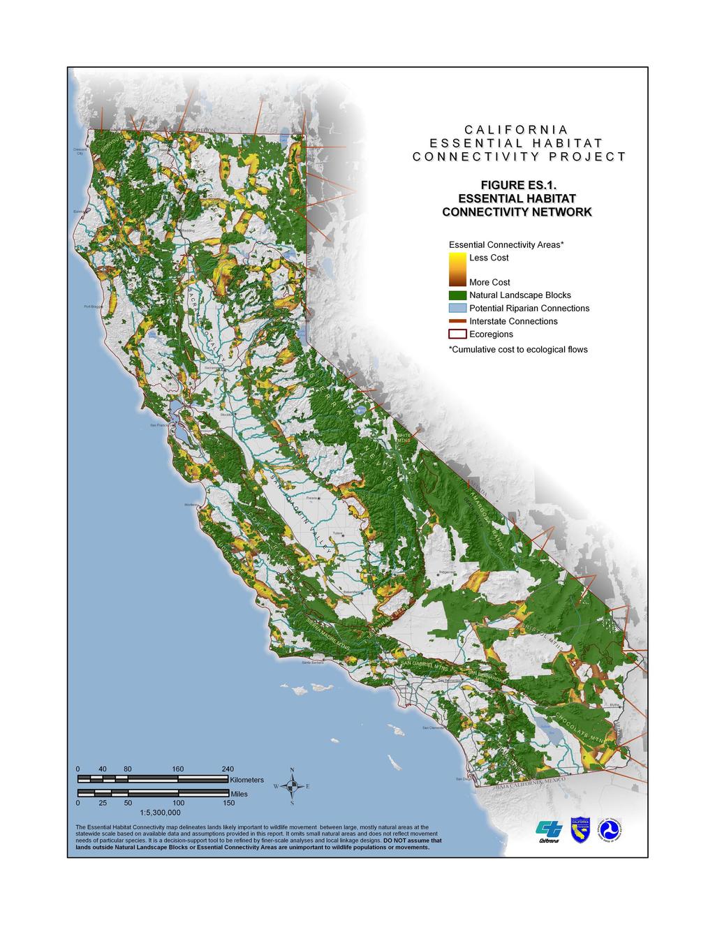
2 xii
3 Essential Connectivity Areas are placeholder polygons that can inform land-planning efforts, but that should eventually be replaced by more detailed Linkage Designs, developed at finer resolution based on the needs of particular species and ecological processes. It is important to recognize that even areas outside of Natural Landscape Blocks and Essential Connectivity Areas support important ecological values that should not be written off as lacking conservation value. Furthermore, because the Essential Habitat Connectivity Map was created at the statewide scale, based on available statewide data layers, and ignored Natural Landscape Blocks smaller than 2,000 acres 2, it has errors of omission that should be addressed at regional and local scales, as discussed in Chapters 4-6. The statewide essential connectivity network consists of 850 relatively intact and wellconserved Natural Landscape Blocks (ranging from 2,000 to about 3.7 million acres each) with over 1,000 potential connections among them. The 192 Essential Connectivity Areas represent principle connections between the Natural Landscape Blocks within which land conservation and management actions should be prioritized to maintain and enhance ecological connectivity. Each Essential Connectivity Area connects from 2 to 15 (on average 4.3) Natural Landscape Blocks across distances averaging roughly 10 to 20 km. In addition to these Essential Connectivity Areas, there are 522 instances where Natural Landscape Blocks were separated only by a road in which case there was no need to delineate a connecting polygon, because sustaining and enhancing functional connectivity across roads is the primary or only conservation action needed (Chapter 6). In addition, the map illustrates that numerous riparian corridors contribute to ecological connectivity throughout the state; and sustaining and enhancing riparian and riverine corridors should remain a high conservation priority whether they are inside or outside of Essential Connectivity Areas and Natural Landscape Blocks. Characterizing Natural Landscape Blocks and Essential Connectivity Areas Data characterizing the Natural Landscape Blocks and Essential Connectivity Areas including their size, physical characteristics, biological characteristics, ownerships, and the roads that cross them are summarized in Chapter 3 and provided in detail in Appendices B and C. These data are also available in electronic databases so that users can select, sort, or weight the various attributes to help prioritize and plan conservation, mitigation, or other actions in or near the Essential Connectivity Areas and Natural Landscape Blocks. Across the state, Natural Landscape Blocks average about 40% in private ownership and 44% in conservation reserves, with over 90% of their area in natural landcovers. Essential Connectivity Areas average about 15 km long, are about 61% in private ownership, have about 13% of their area in conservation reserves, and are over 80% natural landcovers. However, there is tremendous variability in attributes among California s eight diverse run on a data layer that represents the relative permeability of the landscape to wildlife movements, based on land cover naturalness, modified slightly to reflect conservation status. 2 Only areas > 2,000 acres in size that met ecoregion-specific rules for Ecological Condition Index, degree of conservation protection, and support of known high-biological resource values were considered Natural Landscape Blocks. Only Natural Landscape Blocks > 10,000 acres were connected by Essential Connectivity Areas in most regions, and those > 2,000 acres were connected in more developed ecoregions (San Francisco Bay Area, Great Central Valley, South Coast, and Northern Sierra Nevada). xiii
4 ecoregions and individual connectivity areas. Within each ecoregion, Essential Connectivity Areas tend to connect the most ecologically intact and well-conserved lands across generally less intact and protected land. However, optimal approaches to sustaining and enhancing functional connectivity will vary between ecoregions and individual Essential Connectivity Areas to reflect different contexts. For example, in the relatively undeveloped forest and desert ecoregions such as the Sierra Nevada and Mojave Desert many Essential Connectivity Areas connect highly intact wilderness and park lands across private or federally managed multiple-use lands, which support mostly natural landcovers and are relatively permeable to wildlife movements. In these low-contrast situations, managing to sustain wildlife movements between existing protected areas may be the primary conservation approach. In other, more human-altered ecoregions such as the San Francisco Bay Area, Great Central Valley, and South Coast Ecoregion Essential Connectivity Areas tend to connect existing reserves across lands with more roads, agriculture, and urbanization, which can constrain wildlife movements. In such high-contrast situations, there may be greater focus on restoration and enhancement actions to improve ecological connectivity. The California Essential Habitat Connectivity network overlaps considerably with other conservation maps, and it should be seen as complementary to rather than replacing existing conservation maps and plans. For example, the network includes 76% of the protected lands in California, including 99.6% of National Parks, 91% of conservation lands administered by non-governmental organizations, 80% of California Department of Parks and Recreation lands, and 80% of various County conservation lands. The network also overlaps with 41% of the area covered by Habitat Conservation Plans and Natural Community Conservation Plans, and 80% of habitat considered essential to recovery of federally Threatened or Endangered species. Essential Connectivity Areas also support high biodiversity, with an average of 26 special status plant and animal taxa per Essential Connectivity Area. On average, 12% of the land area in Essential Connectivity Areas is Critical Habitat for species listed under the Endangered Species Act. Although the Essential Connectivity Areas were mapped based on coarse ecological condition indicators, rather than the needs of particular species, Essential Connectivity Areas are expected to serve the majority of species in each region. For example, Essential Connectivity Areas in California s South Coast Ecoregion included on average 81% of the area in each of 11 detailed Linkage Designs prepared by the South Coast Missing Linkages project based on the needs of 14 to 34 focal species each. Nevertheless, how well the Essential Connectivity Network actually accommodates wildlife movements is uncertain and will vary tremendously among species and locations. Consequently, future work should focus on assessing functionality of the network for diverse wildlife species and refining the Essential Habitat Connectivity Map and the following recommendations based on the results. Framework for Regional Analysis Given the coarse nature of the Essential Habitat Connectivity Map and the difficulties inherent to prioritizing conservation across such a diverse landscape, this Report provides guidance for mapping connectivity networks at regional and local scales. Regional analyses (Chapter 4) are useful to (1) help planners comprehensively consider regional needs for xiv
5 connectivity, including for natural areas smaller than those mapped in this statewide project; (2) prioritize Essential Connectivity Areas for more detailed planning; and (3) take advantage of spatial datasets not used in this Report because they did not cover the entire state. A regional analysis produces a map of all Natural Landscape Blocks (including small blocks), detailed and implementable conservation plans for the most important connectivity areas, and placeholder polygons for the remaining connectivity areas. A good existing example of a regional analysis is South Coast Missing Linkages and the accompanying 11 individual Linkage Designs for the South Coast Ecoregion (available at The Linkage Designs were developed based on the habitat and movement needs of multiple focal species, and 10 of the 11 designs are being actively implemented. In developing a regional connectivity analysis, it is important to involve end-users early in the design process to collectively agree on what types of areas they want to connect, which areas need connectivity, and which areas merit the highest priority for detailed Linkage Design. The entire process should be transparent and repeatable to build trust and allow updating as new or better data become available. We recommend that regional connectivity analyses identify Natural Landscape Blocks by considering ecological integrity, protection status, biodiversity, and highways, and map Essential Connectivity Areas by least-cost modeling for a broad suite of focal species. In Chapter 4 we describe the advantages and disadvantages of alternative approaches, so that planners can choose the most appropriate methods for their region. If time and budget allow, we recommend conducting detailed Linkage Designs for all potential linkages in a region. More commonly, limited resources will compel planners to develop a few priority Linkage Designs at a time. Nonetheless every regional plan should replace the most crucial placeholder polygons with detailed Linkage Designs using methods described in Chapter 5. Framework for Local-scale Analyses The goal of local-scale analyses is to replace the relatively coarse Essential Connectivity Areas with detailed Linkage Designs that is, maps delineating the specific lands needed to maintain or restore functional connections between two Natural Landscape Blocks and detailed descriptions of the necessary conservation and management actions. Chapter 5 provides a cookbook of step-wise procedures for each major step listed below. Except for the new procedures related to climate change, each set of instructions has a well-established history of use for local-scale analysis in California and elsewhere. Each step should involve collaboration among stakeholders, end-users, implementers, and scientific experts. 1. Delineate Natural Landscape Blocks: Connectivity is meaningful only with reference to the areas to be connected whether they are existing protected areas, suitable habitat for select focal species, or other alternatives. 2. Select focal species: Choose focal species to represent a diversity of habitat requirements and movement needs. Focal species should include area-sensitive species (those with large area requirements, which are often the first to disappear when connectivity is lost), xv
6 barrier-sensitive species (those least likely to traverse roads, urban areas, canals, agricultural fields, or other features), and less mobile species (habitat specialists and those with limited movements). 3. Map corridors for focal species: Conduct least-cost corridor analyses for each focal species to identify one or more swaths of habitat that support movement and gene flow. Consult experts on each focal species to parameterize the model and review the results. 4. Map corridors for climate change: Add additional swaths of habitat to increase the utility of the linkage under an uncertain future climate. We offer an approach that identifies corridors based on land facets or areas of relatively uniform physical conditions that represent the arenas of biological activity, rather than the temporary occupants of those arenas. 5. Evaluate and refine the preliminary Linkage Design. Even the most permeable landscape identified in the previous two steps may not be very permeable for some species. Therefore, assess the spatial distribution of habitat patches for each species and add habitat as needed to the Linkage Design to ensure each species is accommodated. Where possible, impose a minimum width of 2 km to allow occupancy by medium-sized animals and support networks of linked populations for less-mobile species that require multiple generations to move their genes between Natural Landscape Blocks. 6. Assess the Linkage Design in the field: Conduct fieldwork to ground-truth existing habitat conditions, document barriers and passageways, identify restoration opportunities, and consider management options. 7. Develop a Linkage Design Action Plan: Compile results of analyses and fieldwork into a comprehensive report detailing what is required to conserve and improve linkage function, including priority lands for conservation and specific management. Each Linkage Design should be based on existing baseline conditions or (for highly altered areas such as the Central Valley) on context and restorability of habitats, rather than on potential future build-out scenarios. Basing the analysis on future development scenarios may obscure what could be optimal alternatives. Although compromises will occur during implementation, the biological optimum provides a useful reference condition, so that decision-makers can evaluate trade-offs and make good compromises. Guidelines for Addressing Road Impacts The ecological footprint of a road network extends far beyond its physical footprint due to road mortality, habitat fragmentation, and numerous indirect impacts. The Essential Habitat Connectivity analysis identified 552 pairs of Natural Landscape Blocks separated only by a road, and numerous roads cross Essential Connectivity Areas. Chapter 6 therefore provides guidelines for assessing where mitigating road impacts to wildlife movement and ecological connectivity will be most effective, along with guidelines for how best to enhance functional connectivity while reducing the hazards of vehicle-wildlife collisions. In locations where a road crosses a Natural Landscape Block in protected status, the strongest enhancement and mitigation measures should be used. Protected status represents a significant public xvi
7 investment and commitment to ecological integrity, and roads should not compromise that investment. Wildlife crossing structures such as wildlife overpasses, underpasses, bridges, and culverts can facilitate wildlife movement across roads, especially when integrated with appropriate roadside fencing. Because species vary tremendously in their reactions to roads, fences, and different types of crossing structures, multiple types of crossing structures should be constructed and maintained to provide connectivity for all species. The structures should be spaced close enough to allow free movement by species with different spatial requirements, and fencing should keep animals off the road and direct them towards crossing structures. Strategies for Integrating and Institutionalizing the California Essential Habitat Connectivity Project Maintaining and enhancing functional ecological connectivity across California s landscape in the face of human development and climate change is no easy task, and no single agency or small group of agencies can tackle it alone: The 200 members of the Multidisciplinary Team for this Project volunteered to serve as ambassadors for connectivity within and outside their agencies. As described in Chapter 7, each agency has a unique role to play in conserving ecological connectivity while also pursuing its own mission whether it involves improving transportation, delivering water and power, providing recreational opportunities, or conserving biological diversity. Connectivity conservation fits all missions to some degree. The Essential Habitat Connectivity Project was designed to be adopted and used to support planning at multiple scales. At the broadest scale, the products of this Project can serve new or emerging collaborations larger than the state of California, such as the 14-state Western Governors Wildlife Council. At the statewide scale, the Project was intended to support conservation plans like California s Wildlife Action Plan and the California Climate Adaptation Strategy, and to integrate with infrastructure plans such as California Transportation Plan At regional and local scales, the products can be used to inform a wide array of planning efforts, such as Natural Community Conservation Plans and Habitat Conservation Plans, transportation Blueprint Plans, city and county General Plans, and land acquisition, management or restoration plans by conservancies, land trusts, and other nongovernmental organizations. Private landowners may want to use this information to understand how they can be a part of a regional conservation goal or engage in the discussion. Legislation both supports and assures the conservation of connectivity in California. xvii
San Francisco Bay Area Upland Habitat Goals Project
 San Francisco Bay Area Habitat Preserving Biological Diversity for Future Generations A of the Bay Area Open Space Council funding provided by: California State Coastal Conservancy Gordon and Betty Moore
Great Lakes Conservation Blueprint for Terrestrial Biodiversity on the Canadian Shield
 Great Lakes Conservation Blueprint for Terrestrial Biodiversity on the Canadian Shield Bonnie L. Henson 1, Kara E. Brodribb 2 and John L. Riley 3 1 Ontario Ministry of Natural Resources 2,3 The Nature
New Jersey Habitat Connectivity Project
 Mapping Core Team Meeting Two January 25 th, 10 am - noon Assunpink Wildlife Management Area, Main Office Meeting attendees: Patrick Carr, Margaret Conroy, Karl Figueiredo, Gretchen Fowles, Gylla MacGregor,
Preface. Erie. Scranton. Allentown. Pittsburgh. Harrisburg. Philadelphia
 The Southern Alleghenies Region The Southern Alleghenies Region spans the Laurel Highlands and Allegheny Front in the west across the Appalachians to the east. It is comprised of Blair, Bedford, Cambria,
Wildlife Connections 101: Confronting the Challenge of Habitat Fragmentation
 Wildlife Connections 101: Confronting the Challenge of Habitat Fragmentation Dr. Raymond M. Sauvajot U.S. National Park Service Santa Monica Mountains National Recreation Area Habitat Fragmentation and
NJ Habitat Connectivity Initiative
 NJ Habitat Connectivity Initiative Full Working Group Update #1 Spotted Salamander Crossing Road in Northern NJ Wildlife Habitat Connectivity Initiative A strategic plan to reconnect New Jersey s landscape
CHAPTER 1 Introduction
 CHAPTER 1 Introduction From sea to summit, Lane County covers almost 4,800 square miles of diverse Oregon landscape. Stretching from the Pacific Ocean through the Coastal Range, the Willamette Valley to
National Association of Conservation Districts. Kris Hoellen Vice President, Sustainable Programs The Conservation Fund September 19, 2013
 National Association of Conservation Districts Kris Hoellen Vice President, Sustainable Programs The Conservation Fund September 19, 2013 Our Mission The Conservation Fund forges partnerships to conserve
Overview of Southwestern Pennsylvania Commission s (SPC) 2040 Long Range Transportation Plan (LRTP)
 2040 Long Range Transportation Plan (LRTP)") Overview of Southwestern Pennsylvania Commission s (SPC) 2040 Long Range Transportation Plan (LRTP) Presented to Pennsylvania Agency Coordination Meeting May 27, 2015 Doug Smith & Ryan Gordon 1 Southwestern
Overview of Southwestern Pennsylvania Commission s (SPC) 2040 Long Range Transportation Plan (LRTP) Presented to Pennsylvania Agency Coordination Meeting May 27, 2015 Doug Smith & Ryan Gordon 1 Southwestern
Integration of Planning & Environmental Analysis in Transportation
 Integration of Planning & Environmental Analysis in Transportation How Natural Resources Conservation Fits into SAFETEA-LU Planning Rules Transportation Research Board Annual Meeting January 2008 Jeff
Countywide Green Infrastructure
 Montgomery County s Countywide Green Infrastructure F U N C T I O N A L M A S T E R P L A N The Maryland National Capital Park and Planning Commission INFRASTRUCTURE An underlying base or foundation especially
STEWARDSHIP OF LONG ISLAND SOUND S ECOLOGICAL AND RECREATIONAL RESOURCES
 STEWARDSHIP OF LONG ISLAND SOUND S ECOLOGICAL AND RECREATIONAL RESOURCES Robin Kriesberg, Save the Sound, Inc. Thomas Halavik, US Fish and Wildlife Service Coastal Program An Initiative to Identify, Protect
Arlington, Virginia is a worldclass
 EXECUTIVE S U M M A RY Arlington maintains a rich variety of stable neighborhoods, quality schools and enlightened land use policies, and received the Environmental Protection Agency s highest award for
COASTAL CONSERVANCY. Staff Recommendation March 25, 2004 LOS ANGELES GREEN VISION PLAN. File No.: Project Manager: Marc Beyeler
 COASTAL CONSERVANCY Staff Recommendation March 25, 2004 File No.: 04-014 Project Manager: Marc Beyeler RECOMMENDED ACTION: Authorization to disburse up to $50,000 to the University of Southern California
Managing our Landscapes Conversations for Change
 Managing our Landscapes Conversations for Change Frequently Asked Questions The new State Government is committed to a significant reform program that will change the way natural resources are managed.
EXECUTIVE SUMMARY. Introduction
 EXECUTIVE SUMMARY Introduction State Route 68 is a designated scenic route that connects the world-renowned Monterey Peninsula to US Highway 101 and the Salinas Valley. SR 68 is a key route for bicycle,
Describing the Integrated Land Management Approach
 Describing the Integrated Land Management Approach ISBN No. 978-0-7785-8902-0 (Online Edition) Pub No. I/422 What is Integrated Land Management? Integrated land management (ILM) is the strategic, planned
Photo by Carlton Ward Jr. Executive Summary
 Photo by Carlton Ward Jr. Executive Summary The Cooperative Conservation Blueprint (Blueprint) is a multi-partner strategic conservation process developed by the Florida Fish and Wildlife Commission (FWC)
implementation r expression in landscape
 6 ubc okanagan implementation campus plan r expression in landscape 68 6 implementation campus plan sections The Campus Plan supports the academic mission, values and commitments of the University by providing
I ll be talking about the Designing Sustainable Landscapes project today. This is a large integrated modeling effort our group at UMass has been
 1 I ll be talking about the Designing Sustainable Landscapes project today. This is a large integrated modeling effort our group at UMass has been working on for the past 5 years, in close collaboration
2014 South Atlantic LCC
 2014 South Atlantic LCC Annual Report 1 Allie Stewart, U.S. FWS The South Atlantic LCC s 2014 Annual Report this year of progress and accomplishments is dedicated to South Atlantic LCC Coordinator, Ken
NORTHERN LANDS NORTHERN LEADERSHIP
 NORTHERN LANDS NORTHERN LEADERSHIP The GNWT Land Use and Sustainability Framework Our Lands, Our Interests, Our Future ii Land is Life MESSAGE FROM THE PREMIER Land is life. It is the link to our past.
Key Elements of Successful Conservation Planning. John Paskus October 17, 2013 Pierce Cedar Creek Institute Michigan Natural Features Inventory
 Key Elements of Successful Conservation Planning John Paskus October 17, 2013 Pierce Cedar Creek Institute Michigan Natural Features Inventory What is Conservation Planning? Pressey et al (2008): The process
EC Conference on Green Infrastructure Green Infrastructure Applications in the U.S. Kris Hoellen, The Conservation Fund
 EC Conference on Green Infrastructure Green Infrastructure Applications in the U.S. Kris Hoellen, The Conservation Fund The Conservation Fund Partners in Land & Water Conservation Mission & Program Areas
Biodiversity Action Plan Background Information for discussion purposes
 Biodiversity Action Plan Background Information for discussion purposes Our commitment As directed by Council, The City of Calgary has agreed to sign the Durban Commitment, an international agreement on
Green Infrastructure Plan Evaluation Frameworks
 Green Infrastructure Plan Evaluation Frameworks McDonald, L., W. Allen, M. Benedict, & K. O'Connor Keywords green, infrastructure, planning, conservation, landscape, sprawl, framework, evaluation, taxonomy,
Creating Complete Roadway Corridors:
 Creating Complete Roadway Corridors: The AASHTO Guide to Transportation Landscape Architecture and Environmental Design NCHRP Project 15-33 Status Report AASHTO Standing Committee on Design Technical Committee
Review of 12/17/2012 meeting and other core team meetings. Review mapping approaches taken by other states
 Review of 12/17/2012 meeting and other core team meetings Core team working structure, future meeting goals, and general project outline Connectivity planning summary overview Review mapping approaches
INTEGRATING PROTECTED AREAS INTO THE WIDER LANDSCAPE, SEASCAPE AND RELATED SECTORS. An Overview
 INTEGRATING PROTECTED AREAS INTO THE WIDER LANDSCAPE, SEASCAPE AND RELATED SECTORS An Overview USING AN EXAMPLE FROM NORTHEAST US Relationship of IPAWLS guide to other planning and assessment processes
Planning Considerations for Wildlife Passage in Urban Environments. (Prepared by Tony Clevenger, PhD)
") Scope Planning Considerations for Wildlife Passage in Urban Environments. (Prepared by Tony Clevenger, PhD) As urban populations grow and expand into rural areas there are changes in land use patterns
Scope Planning Considerations for Wildlife Passage in Urban Environments. (Prepared by Tony Clevenger, PhD) As urban populations grow and expand into rural areas there are changes in land use patterns
SCORP THE 2019 STATEWIDE COMPREHENSIVE OUTDOOR RECREATION PLAN EXECUTIVE SUMMARY
 THE 2019 STATEWIDE COMPREHENSIVE OUTDOOR RECREATION PLAN EXECUTIVE SUMMARY SCORP Statewide Comprehensive Outdoor Recreation Plan 1 December 11, 2018 Dear Fellow Coloradans, It gives me great pleasure to
Arkansas River Corridor
 Planning for Access Welcome to the Access Project. This project is a recreational planning effort in response to an interest by regional communities along the Arkansas River corridor. The project plan
Conservation by Design: Promoting Resilient Coastal Wetlands & Communities. GreatLakesLCC.org
 Conservation by Design: Promoting Resilient Coastal Wetlands & Communities Brent Schleck The Baldwin Group - NOAA Office for Coastal Management ASFPM 6/22/16 GreatLakesLCC.org Overview 2 Great Lakes coastal
SAN RAFAEL GENERAL PLAN 2040 INTRODUCTION AND OVERVIEW
 SAN RAFAEL GENERAL PLAN 2040 INTRODUCTION AND OVERVIEW Steering Committee Presentation February 14, 2018 Purpose of General Plan Guide land use and development decisions Coordinate transportation, infrastructure,
CALGARY: City of Animals Edited by Jim Ellis
 CALGARY: City of Animals Edited by Jim Ellis ISBN 978-1-55238-968-3 THIS BOOK IS AN OPEN ACCESS E-BOOK. It is an electronic version of a book that can be purchased in physical form through any bookseller
Regional Open Space Conservation Plan. Regional Staff Committee January 18, 2018
 Regional Open Space Conservation Plan Regional Staff Committee January 18, 2018 Schedule We are here Task 1 - Stakeholder Input & Work Plan Dev. v z 2016 2017 2018 Oct Nov Dec Jan Feb Mar Apr May Jun Jul
TOWN OF BETHLEHEM OPEN SPACE CONSERVATION PLAN PUBLIC MEETING: OCTOBER 12, 2017
 TOWN OF BETHLEHEM OPEN SPACE CONSERVATION PLAN PUBLIC MEETING: OCTOBER 12, 2017 Welcome and Agenda 6:00 6:45: Open House, Part One 6:45 7:15: Presentation and Questions 7:15 8:00: Open House, Part Two
I. STAFF POLICY RECOMMENDATIONS. The following RMP policy strategies are proposed by staff in support of a Scenic Resource Protection Program:
 Policy Consideration: Scenic Resource Protection Program Status: For Consideration by the Highlands Council at September 14, 2006 Work session Date: September 12, 2006 I. STAFF POLICY RECOMMENDATIONS The
Road Ecology in Practice: Building Resiliency of Urban Ecosystems through Informed Road Network Planning
 Road Ecology in Practice: Building Resiliency of Urban Ecosystems through Informed Road Network Planning Outline What is road ecology? Why is road ecology important? TRCA and road ecology application Peel
EACCS Goal: provide guidelines for mitigation practices and overall conservation in east Alameda County
 EAST ALAMEDA COUNTY CONSERVATION STRATEGY: A BLUEPRINT FOR ACTION Community Meeting June 11, 2009 Agenda Welcome and Introductions Project Update o Introduction o Progress to Date o Next Steps Perspectives
systems is available on the Colorado Wetland Information Center (CWIC) website.
 website.") Colorado Natural Heritage Program Wetland Program Plan -- Dec 2015 Status Update and Addendum -- The Colorado Natural Heritage Program (CNHP) developed a Wetland Program Plan (WPP) in 2010 for the planning
Colorado Natural Heritage Program Wetland Program Plan -- Dec 2015 Status Update and Addendum -- The Colorado Natural Heritage Program (CNHP) developed a Wetland Program Plan (WPP) in 2010 for the planning
WELCOME TO THE CHOUTEAU GREENWAY DESIGN, DEVELOPMENT AND CONSTRUCTION WORKING GROUP!
 WELCOME TO THE CHOUTEAU GREENWAY DESIGN, DEVELOPMENT AND CONSTRUCTION WORKING GROUP! Chouteau Greenway Steering Committee and Working Groups Overview Overview January 9, 2019 Chouteau Greenway will transform
THE CORPORATION OF THE CITY OF WINDSOR Office of the City Solicitor Planning Department
 THE CORPORATION OF THE CITY OF WINDSOR Office of the City Solicitor Planning Department REPORT TO THE CITY OF WINDSOR PLANNING ADVISORY COMMITTEE DATE OF REPORT: August 19, 2010 SUBJECT: Official Plan
Plan Overview. Manhattan Area 2035 Reflections and Progress. Chapter 1: Introduction. Background
 Plan Overview The Manhattan Urban Area Comprehensive Plan (the Comprehensive Plan) is a joint planning initiative of the City of Manhattan, Pottawatomie County, and Riley County. The 2014 Comprehensive
EXECUTIVE SUMMARY. Introduction
 Introduction EXECUTIVE SUMMARY The Urban Service Area Fort McMurray (hereafter referred to as the Urban Service Area) is currently experiencing a variety of development pressures. Unprecedented population
Florida Greenways and Trails System (FGTS) Plan Goals, Strategies and Objectives
 Plan Goals, Strategies and Objectives") Identification and Prioritization of the FGTS The Florida Greenways and Trails System (FGTS) is made up of existing, planned and conceptual trails and ecological greenways that form a connected, integrated
Identification and Prioritization of the FGTS The Florida Greenways and Trails System (FGTS) is made up of existing, planned and conceptual trails and ecological greenways that form a connected, integrated
ADOPTION OF THE REVISED OPEN SPACE AND CONSERVATION ELEMENT OF THE GENERAL PLAN
 TO: FROM: SUBJECT: Honorable Mayor and City Council Planning Department ADOPTION OF THE REVISED OPEN SPACE AND CONSERVATION ELEMENT OF THE GENERAL PLAN RECOMMENDATION: It is recommended that the City Council:
Category for Proposal: Partner Forums
 Project Title: Strategic conservation planning for management applications in Cascadia. Project Coordinator: Jen Watkins (Conservation Northwest, jwatkins@conservationnw.org) Project PIs: Cascadia Partner
Master Plan Objectives and Policies
 Master Plan Objectives and Policies Introduction This chapter identifies the Park issues and recommended policies established by this Master Plan. The issues were identified through meetings with staff,
10.0 Open Space and Public Realm
 10.0 Open Space and Public Realm 10.0 Open Space and Public Realm The Public Open Space System is comprised of: outdoor spaces available for public use that are either publicly owned (e.g., parks and
Town of Peru Comprehensive Plan Executive Summary
 Town of Peru Comprehensive Plan Executive Communities that plan grow by choice, not by chance. A plan makes growth thoughtful, understandable, and predictable. A plan shows that a community is managing
A Delta Renewed: A Guide to Science Based Ecological Restoration in the Delta
 A Delta Renewed: A Guide to Science Based Ecological Restoration in the Delta J. Letitia Grenier, San Francisco Estuary Institute, letitia@sfei.org Julie Beagle, San Francisco Estuary Institute, julieb@sfei.org
Resolution XII NOTING also that with the increasingly rapid urbanization, wetlands are being threatened in two principle ways:
 12 th Meeting of the Conference of the Parties to the Convention on Wetlands (Ramsar, Iran, 1971) Punta del Este, Uruguay, 1-9 June 2015 Resolution XII.10 Wetland City 1 Accreditation of the Ramsar Convention
3. VISION AND GOALS. Vision Statement. Goals, Objectives and Policies
 Vision Statement Queen Creek s interconnected network of parks, trails, open spaces and recreation opportunities provide safe and diverse activities and programs that sustain its unique, small town, equestrian
GREEN NETWORK APPLICATIONS IN ESTONIA
 GREEN NETWORK APPLICATIONS IN ESTONIA Kalev Sepp, Tuuli Veersalu, Martk Külvik Estonian University of Life Sciences 1 WHY? BACKGROUND - POLITICAL By adopting the Pan-European Biological and Landscape Diversity
NEW YORK AND CONNECTICUT SUSTAINABLE COMMUNITIES. Fair Housing & Equity Assessment & Regional Planning Enhancement
 NEW YORK AND CONNECTICUT SUSTAINABLE COMMUNITIES Fair Housing & Equity Assessment & Regional Planning Enhancement November 12, 2013 Yonkers Public Library Federal grant to improve regional planning to
Project Summary. Rationale
 Modeling and Evaluating Potential Constraints Between Siting of Commercial Wind Power and Ecological and Social Values in the Mountains of the Northern Forest Principal Investigator(s): Dr. David Publicover
Cotswolds AONB Landscape Strategy and Guidelines. June 2016
 Cotswolds AONB Landscape Strategy and Guidelines June 2016 Cotswolds AONB Landscape Strategy and Guidelines Introduction The evolution of the landscape of the Cotswolds AONB is a result of the interaction
Western Sydney Parklands Australia s Largest Urban Park
 Western Sydney Parklands Australia s Largest Urban Park 37 WLA 1 MAGAZINE 21 38 WESTERN SYDNEY PARKLANDS AUSTRALIA S LARGEST URBAN PARK Large urban parks have dual roles to play in meeting the demands
Virginia DCR- Natural Heritage Program. Tools for Linking Conservation and Transportation Planning
 Virginia DCR- Natural Heritage Program Tools for Linking Conservation and Transportation Planning November 9, 2009 MISSION: to conserve Virginia's biodiversity through statewide biological inventory, protection,
Draft Resolution XII.10
 12 th Meeting of the Conference of the Parties to the Convention on Wetlands (Ramsar, Iran, 1971) Punta del Este, Uruguay, 1-9 June 2015 Ramsar COP12 DR10, Rev. 2 21:45, 8 June Draft Resolution XII.10
NEW REGIONAL OFFICIAL PLAN HIGH LEVEL PROCESS & FRAMEWORK
 NEW REGIONAL OFFICIAL PLAN HIGH LEVEL PROCESS & FRAMEWORK Why A New Official Plan Originally the role of Regionally Planning and content of Regional Official Plan (1970s) primarily focused on protecting
Scottish Natural Heritage. Better places for people and nature
 Scottish Natural Heritage Better places for people and nature Contents Summary... 3 SNH approach... 5 Place-making in policy and practice... 6 Developing the contribution of the natural heritage to place-making...
Parks Master Plan Implementation: Phase I Waterfront Use and Design REPORT #: September 7, 2016 File #
 0 'O DI Lan-171-14 1 - THE CORPORATION OF THE TOWN OF COBOURG..,. STAFF REPORT TO: FROM: Mayor and Members of Council Dean A. Hustwick, Director of Recreation and Culture DATE OF MEETING: Committee of
Lower Columbia River and Coastal Landscape Conservation Design
 Today s Presenters: Lower Columbia River and Coastal Landscape Conservation Design John Mankowski, North Pacific Landscape Conservation Cooperative Sara Evans-Peters, Pacific Birds Tom Miewald, US Fish
ROLE OF LANDSCAPE CONSERVATION COOPERATIVES IN EVERGLADES RESTORATION
 ROLE OF LANDSCAPE CONSERVATION COOPERATIVES IN EVERGLADES RESTORATION GEER April 2017 Steve Traxler 1, Todd Hopkins 1, Beth Stys 2 1 US Fish and Wildlife Service 2 Florida Fish & Wildlife Conservation
Blue/Green Infrastructure Study Accomack County, VA
 Blue/Green Infrastructure Study Accomack County, VA Draft Asset Maps March 8-9, 2010 Green Infrastructure Center, Inc. 2 Overview What is Green and Blue Infrastructure Project Timeline & Tasks Literature
Santa Barbara Restoration Project Database. Cheadle Center for Biodiversity and Ecological Restoration University of California, Santa Barbara
 University of California, Santa Barbara 1 CONTENTS Introduction... 2 Setting... 2 Methods... 3 Results... 5 Discussion... 10 Conclusions... 12 2 INTRODUCTION The Santa Barbara Restoration Project Database
Pathway to 2020 Protected Areas Workshop for New Brunswick
 Pathway to 2020 Protected Areas Workshop for New Brunswick Setting the Stage for New Brunswick Roberta Clowater Executive Director, Canadian Parks and Wilderness Society NB Chapter 1 Convention on Biological
Colorado Outdoor Partnership
 Colorado Outdoor Partnership Quick Facts 2017 SHIFT Award Winner Public Land Management Innovation Category Year Founded: 2016 Member agencies and organizations: 32 Executive Summit Coalition The Problem:
KITT PEAK LINKAGE WILDLIFE CONNECTIVITY: WILDLIFE OVERPASSES AND FENCING. State Route 86
 KITT PEAK LINKAGE WILDLIFE CONNECTIVITY: WILDLIFE OVERPASSES AND FENCING State Route 86 Tohono O odham Nation Department of Natural Resources Wildlife and Vegetation Management Program In partnership with
Rapid Transit Implementation Working Group September 14, 2017
 Rapid Transit Implementation Working Group September 14, 2017 BACKGROUND Council approved the Rapid Transit Master Plan and Updated Business Case on July 25, 2017. Approval of the RTMP confirmed the BRT
Green Infrastructure Case Study Template
 Green Infrastructure Case Study Template The aim of the exercise is to provide information on how the elements of the Green Infrastructure Strategy are implemented at national level and to provide case
INTERMOUNTAIN WEST JOINT VENTURE Strengthening Alliances for Conservation
 INTERMOUNTAIN WEST JOINT VENTURE Strengthening Alliances for Conservation THE PEOPLE OF THE IWJV The people of the Intermountain West are our greatest asset. We, at the IWJV, believe in forging productive,
California State Parks
 California State Parks State Parks and Natural Resources 94% of land base is un-developed 31% of the state s endangered, threatened or rare species 19 units with national or international recognition
INTRODUCTION. Strive to achieve excellence in all areas of operational sustainability.
 1 INTRODUCTION 1 INTRODUCTION A master plan guides the physical development of a campus, presenting long-range strategies for campus growth and transformation. As no single issue can be considered in isolation,
Public Review Draft Oceanside Subarea Habitat Conservation Plan/ Natural Communities Conservation Plan
 Oceanside Subarea Habitat Conservation Plan/ Natural Communities Conservation Plan Prepared for City of Oceanside Planning Department 300 N. Coast Highway Oceanside, CA 92054 Prepared by Ogden Environmental
A Landscape Scale Approach to Habitat Conservation
 A Landscape Scale Approach to Habitat Conservation Sara Vickerman December 2012 Why this session? Disconnect between landscape level assessments and planning, and transactions on-the-ground focused on
Green Infrastructure Project Guidance
 OTHER OPTIONS Green Infrastructure Project Guidance Stakeholder Informed Introduction Green infrastructure is an approach to mitigating environmental challenges using vegetation, soils and natural processes
California Landscape Conservation Cooperative
 californialcc.org California Landscape Conservation Cooperative Debra Schlafmann, Coordinator October 19, 2016 Landscape Conservation Cooperatives There are 22 LCCs http://lccnetwork.org/ LCC Map Landscape
CITY OF CHARLOTTESVILLE, VIRGINIA CITY COUNCIL AGENDA
 CITY OF CHARLOTTESVILLE, VIRGINIA CITY COUNCIL AGENDA Agenda Date: December 16, 2013 Action Required: Adoption of Resolution Presenter: Staff Contacts: Title: James E. Tolbert, AICP, Director of NDS James
Case Study: City of San Mateo
 Published on GreenPlan-IT (http://greenplanit.sfei.org) Home > Archived Materials > GreenPlan-IT Toolkit Demonstration Report > Chapter 2. Case Study: City of San Mateo Case Study: City of San Mateo Chapter
Slope Stability Management Framework
 Slope Stability Management Framework For the assessment, evaluation, prioritization and mitigation of slope stability concerns. 2013/06/19 The Slope Stability Management Framework provides guidance to
Rocky Areas Project Guidance HABITAT
 Rocky Areas Project Guidance HABITAT Introduction Rocky habitats are surface areas dominated by exposed rock, such as mountain peaks, inland cliffs, buttes and rocky outcrops. In many cases, rocky areas
The Landscape Project. New Jersey Department of Environmental Protection Division of Fish and Wildlife Endangered and Nongame Species Program
 The Landscape Project New Jersey Department of Environmental Protection Division of Fish and Wildlife Endangered and Nongame Species Program New Jersey is One of the smallest states in the country Yet
Office of Greenways & Trails Providing Statewide Leadership and Coordination. Southeast Greenways and Trails Summit October 1-3, 2017
 Office of Greenways & Trails Providing Statewide Leadership and Coordination Southeast Greenways and Trails Summit October 1-3, 2017 1 Office of Greenways and Trails The Office of Greenways and Trails
SUSTAINABILITY PLAN OTTAWA COUNTY PARKS AND RECREATION COMMISSION FALL 2017
 SUSTAINABILITY PLAN OTTAWA COUNTY PARKS AND RECREATION COMMISSION FALL 2017 Table of Contents Introduction Natural Resources Quality of Life Community Continuing the Mission Sustainability Measuring Sustainability
Prioritizing Tidal Wetlands: A Landscape Approach
 Prioritizing Tidal Wetlands: A Landscape Approach Laura Brophy Director, Estuary Technical Group Institute for Applied Ecology Corvallis, OR College of Earth, Ocean and Atmospheric Sciences, Oregon State
Peninsular Florida Landscape Conservation Cooperative. Marine and Estuarine Priority Resources and Conservation Targets
 Peninsular Florida Landscape Conservation Cooperative Marine and Estuarine Priority Resources and Conservation Targets Why are we here today? Workshop Goals: Develop a list of potential conservation targets
BLM s Landscape Approach
 s Landscape Approach s Landscape Approach Conservation Planning in Nevada January 14, 2013 John M Wilson Healthy Landscapes Program Lead, Nevada Purpose of Today s Discussion Provide an overview of the
A Proposed Modelling and Scenariobased Approach for Identifying Natural Heritage Systems in Southern Ontario Discussion Paper
 A Proposed Modelling and Scenariobased Approach for Identifying Natural Heritage Systems in Southern Ontario Discussion Paper Ministry of Natural Resources Draft - October 2006 Executive Summary Under
Historic Asset Management A Decision Support Process for Balanced Consideration of Mission Utility, Historic Value, and Facility Condition
 Historic Asset Management A Decision Support Process for Balanced Consideration of Mission Utility, Historic Value, and Facility Condition Joe Lockerd; Cardno TEC Kurt Schweigert; Cardno TEC Adriane Fowler
Florida Forever Conservation Needs Assessment Overview Maps
 Florida Forever Conservation Needs Assessment Overview Maps Prepared by Florida Natural Areas Inventory, The maps in this document are derived from the Florida Forever Conservation Needs Assessment, an
Development of a Resource Planning Index for Washington's Scenic and Recreational Highways
 Development of a Resource Planning Index for Washington's Scenic and Recreational Highways WA-RD 740.1 Kevin Ramsey February 2010 WSDOT Research Report Office of Research & Library Services Final Technical
This page intentionally blank.
 This page intentionally blank. Parks, Recreation, and Open Space Chapter Relationship to Vision Vision Parks, Recreation and Open Space Chapter Concepts County Government. County government that is accountable
3.0 PROJECT DESCRIPTION
 3.0 PROJECT DESCRIPTION 3.1 BACKGROUND Under California law (Government Code Section 65300 et seq.), every city and county is required to have a general plan. The general plan is to be comprehensive and
COASTAL CONSERVANCY. Staff Recommendation June 5, 2008 SAN DIEGO RIVER TRIBUTARY CANYONS PROJECT. File No Project Manager: Megan Johnson
 COASTAL CONSERVANCY Staff Recommendation June 5, 2008 SAN DIEGO RIVER TRIBUTARY CANYONS PROJECT File No. 08-059 Project Manager: Megan Johnson RECOMMENDED ACTION: Authorization to disburse an amount not
WELCOME TO THE CHOUTEAU GREENWAY EQUITY WORKING GROUP!
 WELCOME TO THE CHOUTEAU GREENWAY EQUITY WORKING GROUP! Chouteau Greenway Steering Committee and Working Groups Overview Overview January 9, 2019 Chouteau Greenway will transform St. Louis by connecting
Public Review Draft Encinitas Subarea Plan
 Encinitas Subarea Plan Prepared for City of Encinitas Community Development Department 505 S. Vulcan Encinitas, California 92024 Prepared by Ogden Environmental and Energy Services Co., Inc. 5510 Morehouse
Waco Mammoth Site Special Resource Study
 Waco Mammoth Site Waco, Texas Newsletter #2 August 2007 National Park Service U.S. Department of the Interior Waco Mammoth Site Special Resource Study We are pleased to share with you an update on the