Long Distance Landscapes
|
|
|
- Chloe Patrick
- 5 years ago
- Views:
Transcription


1 Long Distance Landscapes CONDUCTING A BASELINE VISUAL ASSESSMENT FOR THE PACIFIC NORTHWEST NATIONAL SCENIC TRAIL Presented by: Brad Cownover and Matt Ramich Landscape Architects, US Forest Service
2 OVERVIEW: Pacific Northwest National Scenic Trail Objectives & Benefits Methods & Results Next Steps & Lessons Learned


3 HISTORY OF THE PNT 1970: Ron Strickland s big idea 1977: First thru-hike completed by Janet Garner & Rex Bakel 1980: Feasibility study 1990s: First local trail maintenance organization formed 2000s: Volunteers advocated for National Scenic Trail status 2009: Congress designated the PNT as a National Scenic Trail

4 Pacific Northwest National Scenic Trail

5 No one owns the view of scenic resources.
6 No one owns the view of scenic resources. The charming landscape which I saw this morning is indubitably made up of some twenty or thirty farms. Miller owns this field, Locke that, and Manning the woodland beyond. But none of them owns the landscape This is the best part of these men's farms, yet to this their warranty-deeds give no title. Ralph Waldo Emerson
7 BENEFITS Document existing conditions Monitor change over time Assist with Optimal Location Review Protect Quality of Trail Experience Defines Zones of Experience Restore / Enhance (from what, to what?) Public Lands Private Land (Scenic Easements, Acquisition, etc.) Inform Comprehensive Plan

8 PROJECT OVERVIEW
9 LANDSCAPE ARCHITECTURE DETAIL Byron Stringham David Fothergill Matt Ramich
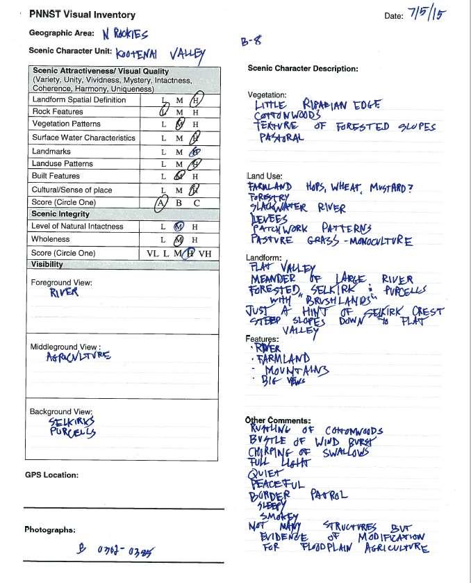
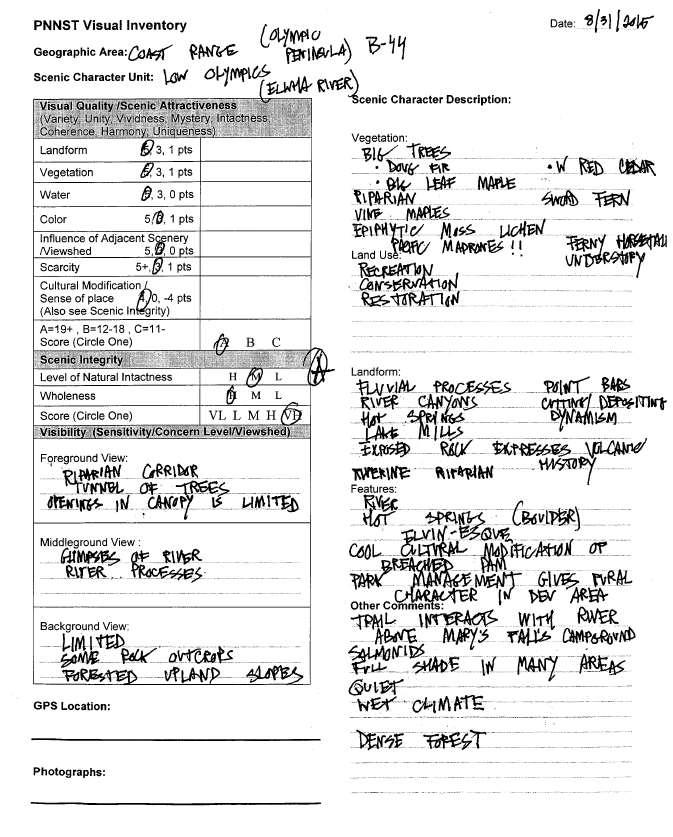
10 OBJECTIVES AND PRINCIPLES Compile existing scenery resource information currently available across multiple jurisdictions Obtain a baseline visual (scenic) inventory and landscape character assessment; Evaluate existing landscape (scenic) character; Produce a seen area (visibility) and viewshed analysis; Evaluate existing scenic integrity and stability; and Complete an on site (field based) visual resource analysis and photographic documentation from the trail corridor.
11

12


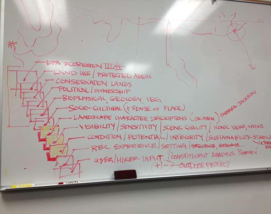
13 MERGING TWO SYSTEMS Forest Service Scenery Management System Referenced Terminology from USFS Landscape Management and Landscape Aesthetics, Agriculture Handbook 701 for scenery analysis. Bureau of Land Management Visual Resource Inventory Referenced Terminology from BLM Manual H
14 The SCENIC Resource Principles Condition Sensitivity to Change Visibility Visual Quality Concern Levels Distance Zones Landscape (Scenic) Character
15 FLOW CHART WALKTHROUGH
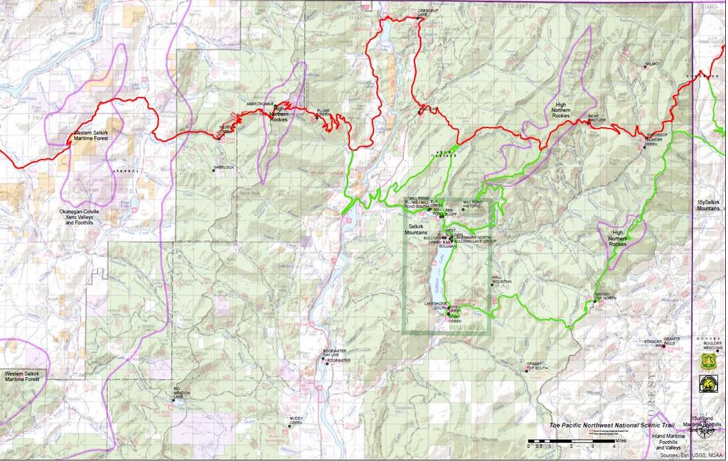
16 WALKTHROUGH CONTINUED


17 Landscape (Scenic) Character A combination of the physical, biological and cultural images that gives an area its positive scenic identity and contributes to its sense of place. Scenic Character the essential scenery resource to be protected and restored Seen Experience of the PNT Traveler
18 WALKTHROUGH CONTINUED
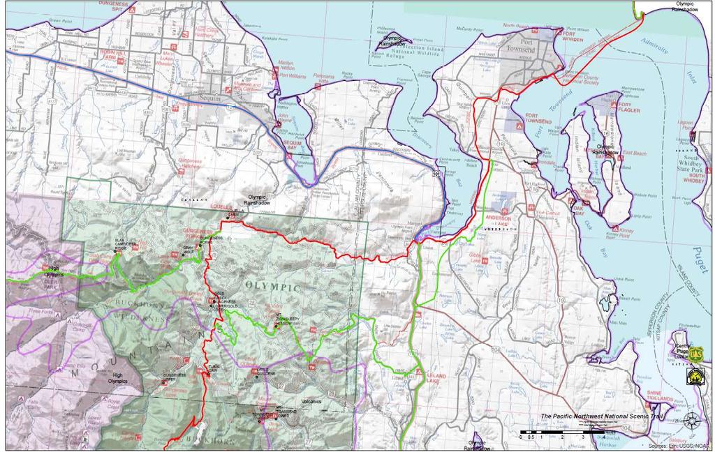
19
20

21 REGIONS ZONES

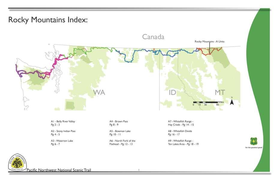
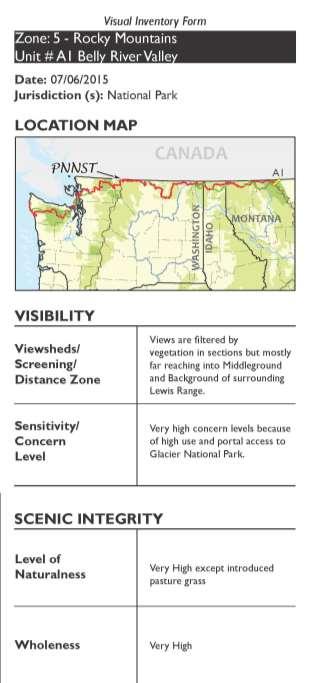
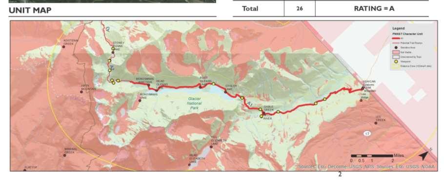
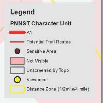
22 REGIONS Rocky Mountains A Units
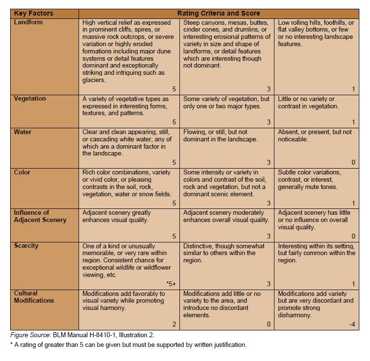
23 REGIONS Columbian Rockies - B Units
24 REGIONS North Cascades C Units

25 REGIONS Puget Sound D Units
26 REGIONS Olympic Peninsula E Units
27 WALKTHROUGH CONTINUED

28 Visual (Scenic) Quality/ Scenic Attractiveness Measures the scenic importance of a landscape based upon perceptions of the intrinsic beauty of landform, rock form, vegetative patterns, water characteristics, cultural land use. Class A = Distinctive Class B = Typical Class C = Indistinctive Variety Unity Vividness Mystery Intactness Coherence Harmony Uniqueness Pattern Balance Physiographic Province
29


30 Scenic Quality Seven scenic quality factors Landform Vegetation Water Color Adjacent Scenery Scarcity Cultural Modifications
31
32
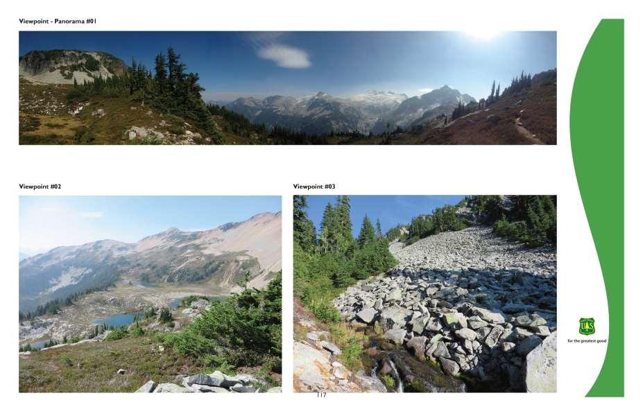
33 WALKTHROUGH CONTINUED


34 Constituent Information how people use area preferences and thresholds for scenery condition PNT-Local Field Office as surrogates for formal survey of trail hikers Crowd-source potential geo-photos Comp. Planning can augment
35 WALKTHROUGH CONTINUED

36 Concern Levels A measure of public concern for scenery as viewed from travel ways, use areas, and special places. Based on numbers of viewers & social importance of the scenery high 1 moderate 2 low 3
37 WALKTHROUGH CONTINUED

38 Landscape Visibility background = 4 mi to horizon seldom seen areas middleground = 1/2 to 4 miles foreground = 300 to ½ mile immediate foreground = feet
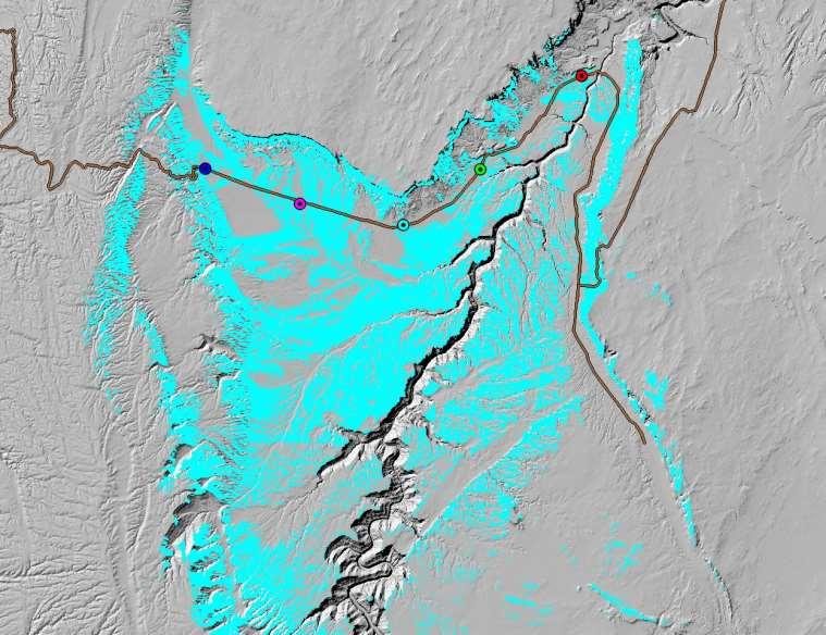
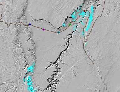
39 Viewsheds

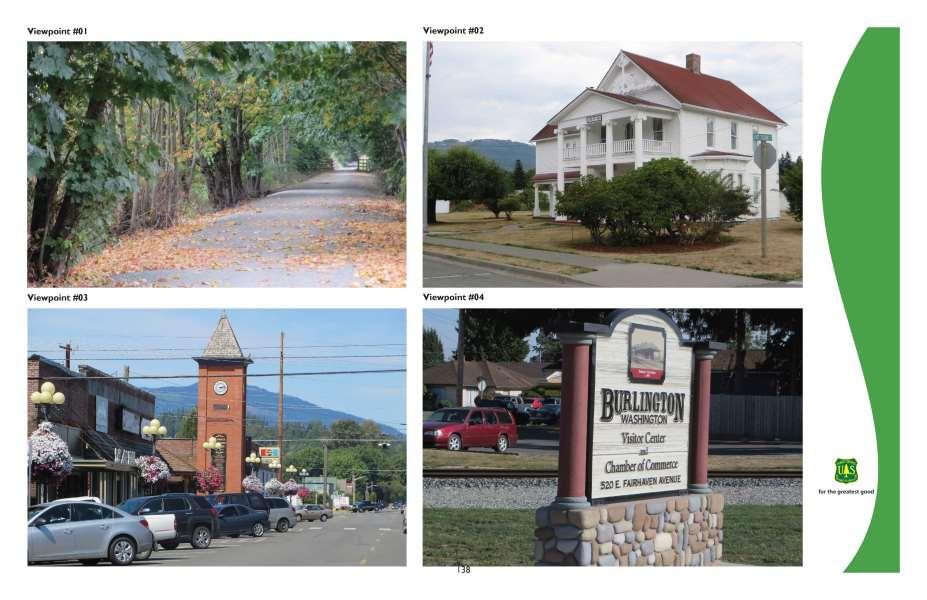
40 PHOTO INVENTORY POINTS Gaps Grizzly Country Pasayten Wilderness Relied on Photographs from Local Units Hiked/ Biked and Photographed ¼ of Total Trail Miles Sampled 85-95% of all Landscape Inventory Units
41 WALKTHROUGH CONTINUED

 moderate")

42 KEY INDICATOR Scenic Integrity measures scenery disturbance of the scenic character, in 6 levels: SIO VQO very high no disturbance P high unnoticed disturbance R moderate minor disturbance PR low co-dominant disturbance M very low strong disturbance MM no integrity excessive disturbance UM very high integrity (Preservation VQO) moderate integrity (Partial Retention) vqo Scenic Integrity is emphasized within view of travelways, use areas and special places measures existing/future disturbance & can define thresholds for future disturbance no integrity (Unacceptable Modification)
43 WALKTHROUGH CONTINUED SUSTAINABILITY- STABILITY -ecological -social
44 WALKTHROUGH CONTINUED
45 WALKTHROUGH CONTINUED
46 WALKTHROUGH CONTINUED

47 REGIONS SUB-REGIONS LANDSCAPE ROOMS
48

49 REGIONS VISUAL INVENTORY FORMS
50
51
52
53
54
55
56
57

58
59
60
61

62 SORP Conference BOISE, 2016 IDAHO - Boise, Idaho

63 SORP Conference BOISE, 2016 IDAHO - Boise, Idaho
64 NEXT STEPS

65 WHAT S NEXT? Comprehensive Plan


66 SMS ELEMENT Scenic Class Relative Scenery Importance,1 to 7 scale Based on Attractiveness Public Concern Level Viewing Distance/Visibility Scenic Class Map
67 Quantification, Synthesis, Analysis Scenic Quality (% A/B/C) Sensitivity (% H/M/L) Existing Scenic Integrity (% VH, H, M, L, VL) SCENIC CLASSES~ relative scenic importance (DESIRED FC) Land Jurisdiction (% federal/ state/ private/ other) Federal: NPS/FS/BLM/FWS etc. Private: Small/Large/ Corporate Level of Protection Designation- (Wilderness, WSR, or not ) Conservation Easements (agr/scenic ) Other projection (hillside, historic overlay )
68 COMP. PLAN (ACTION PLAN) Prioritization of Lands for Protection Forest Planning Geographic Areas & Overlay Mgt. Area & Corridor Land Acquisition, Conservation Easements, Voluntary Measures MANY APPROACHES.. ILARIS (Puget Sound TPL Greenprint) Visual Prioritization Process (AZ Trail using) Compensatory Mitigation: Information can help with identifying areas that might be targeted for scenic restoration, enhancement as offset for unavoidable impacts from nearby projects as part of a compensatory mitigation.

69 LESSONS LEARNED Benefits of Hybrid System Importance of Actual FIELD BASED Inventory Information for Future Route Alternatives Tap into Experience of Nomadic PERPETUAL HIKERS


70 in memoriam
Galiuro Drilling EA Scenery Debby Kriegel 12/9/16
 Galiuro Drilling EA Scenery Debby Kriegel 12/9/16 INTRODUCTION The 1.7 million acre Coronado National Forest (CNF) is comprised of 12 sky island mountain ranges. CNF visitors have opportunities to sightsee
Preservation of Scenery National Historic Trails. Rob Sweeten BLM Kevin Rauhe EPG
 Preservation of Scenery National Historic Trails Rob Sweeten BLM Kevin Rauhe EPG EPG Background Landscape architects with expertise in visual resources Resource staff includes: archaeologists, biologists,
Nob Hill Pipeline Improvements Project EIR
 Section 3.1 Aesthetics This section addresses the visual aspects that may affect the views experienced by the public, including the potential to impact the existing character of each area that comprises
Appendix 17A Scenic Quality Rating Forms
 1 2 Appendix 17A Scenic Quality Rating Forms UNITED STATES DEPARTMENT OF THE INTERIOR BUREAU OF LAND MANAGEMENT SCENIC QUALITY RATING SUMMARY Date: March 7, 2018 Landscape Character Unit: N/A Key Observation
Project Analysis and Evaluation. UNIT 10 Project Analysis and Evaluation
 Project Analysis and Evaluation UNIT 10 Project Analysis and Evaluation 1 Objective Provide accurate and complete information to the decision maker. 2 Initial Project Considerations What is your role?
Relevance of Scenic Resources Management:
 Relevance of Scenic Resources Management: Panel on Benefits, Applications and Challenges Joan Harn, NPS, moderator Greg Currie, BLM Lisa Klinger, USFS Susan Overson, NPS ~ 30 years 3 bridge proposals 2
The analysis area for the scenic resource is the project area described in Chapter 1. Affected Environment/Existing Condition
 Chapter 3 - Scenic Resource SCENIC RESOURCES Introduction The Spotted Bear Ranger District is a destination point for outdoor recreation activities and offers a variety of recreation opportunities: driving
Glossary. Acceptable Levels of Quality The lowest standard permissible in the constituents' view.
 Glossary Acceptable Levels of Quality The lowest standard permissible in the constituents' view. Aesthetics (Esthetics) Generally, the study, science, or philosophy dealing with beauty and with judgments
APPENDIX V FRAMEWORK VISUAL RESOURCES MANAGEMENT PLAN
 APPENDIX V FRAMEWORK VISUAL RESOURCES MANAGEMENT PLAN TABLE OF CONTENTS V1.0 INTRODUCTION... 1 V1.1 PLAN PURPOSE... 1 V1.2 PLAN UPDATES... 1 V1.3 AGENCY-SPECIFIC LAWS, REGULATIONS AND STANDARDS... 1 V1.3.1
Arizona National Scenic Trail Planning Considerations
 Arizona National Scenic Trail Planning Considerations Prepared by Greg Warren NSTrail.org National Scenic Trail Technical Paper Tonto Forest Plan Revision Assessment and Need for Change January 4, 2017
Visual Impact Assessment 830 Pratt Avenue St Helena, CA
 Visual Impact Assessment 830 Pratt Avenue St Helena, CA 1. Introduction The following aesthetic visual impact assessment has been prepared pursuant to the California Environmental Quality Act (CEQA). The
6.3 VISUAL RESOURCES. Landscape Character
 6.3 VISUAL RESOURCES 6.3.1 Affected Environment The DMR discussion is divided into two areas, DMR and Dillingham Trail, which would extend from SBMR to DMR. The ROI includes all areas within the line of
Scenic Resources Revised 7/19/2011
 1 Scenic Resources Revised 7/19/2011 Affected Environment The existing characteristic landscape of the Kiowa and Rita Blanca National Grasslands includes high mesas, dissected plateaus, deep canyons, volcanic
Draft Stillwater 2030 Comprehensive Plan- Goals and Policies
 Draft Stillwater 2030 Comprehensive Plan- Goals and Policies Instructions- Review each goal and policy and discuss with group any changes, deletions for additions to the list using your groups pen. Keep
5.8 Visual Resources and Aesthetic Qualities
 I-70 East Supplemental Draft EIS 5.8 Visual Resources and Aesthetic Qualities 5.8 Visual Resources and Aesthetic Qualities This section discusses the visual resources and aesthetic qualities of the study
ROSEMONT 138kV TRANSMISSION LINE PROJECT. Public Open House Meeting #2 August 27, 2009
 ROSEMONT 138kV TRANSMISSION LINE PROJECT Public Open House Meeting #2 August 27, 2009 Project Overview Tucson Electric Power (TEP), as a part of its obligation to serve, is proposing to construct and operate
CHAPTER 10 AESTHETICS
 CHAPTER 10 AESTHETICS CHAPTER 10 AESTHETICS This section identifies and evaluates key visual resources in the project area to determine the degree of visual impact that would be attributable to the project.
ROUTE 340 VIEWSHED SURVEY: MAPPING & SCENIC AREA PRIORITIZATION
 ROUTE 340 VIEWSHED SURVEY: MAPPING & SCENIC AREA PRIORITIZATION JEFFERSON COUNTY, WEST VIRGINIA JUNE 2010 Prepared for Jefferson County Historic Landmarks Commission Prepared by together with Carol Truppi
4.5 Visual and Aesthetic Resources
 4.5 Visual and Aesthetic Resources 4.5.1 Summary Table 4.5-1 shows how many homes would have reduced visual quality under each alternative. Measures like the ones suggested in Section 4.5.5, Potential
5.13 RECREATION / OPEN SPACE
 5.13 RECREATION / OPEN SPACE The project includes the development of two 5+ acre public parks, four pocket parks and various trails. This complies with the Board of Supervisors established minimum standard
IV.B. VISUAL RESOURCES
 IV.B. VISUAL RESOURCES ENVIRONMENTAL SETTING Existing Visual Character Project Site The project site is located at 17331-17333 Tramonto Drive in the Pacific Palisades community of the City of Los Angeles
Tower Fire Salvage and Reforestation Project
 Tower Fire Salvage and Reforestation Project Scenery Report Prepared by: Morai Helfen Forest Landscape Architect for: Priest Lake Ranger District Idaho Panhandle National Forests Date March 26, 2016 In
Reviewing Officer, USDA Forest Service, Rocky Mountain Region. Greg Warren, 22 S Juniper Ct, Golden, CO ; phone is not available
 To: Attn: Reviewing Officer, USDA Forest Service, Rocky Mountain Region Objection Reviewing Officer Planning Department 740 Simms, Golden, CO 80401 Email to: r02admin_review@fs.fed.us Subject: From: SBEADMR
The impacts examined herein take into account two attributes of aesthetic values:
 IV. ENVIRONMENTAL IMPACT ANALYSIS This section addresses the potential impacts to views and aesthetics as a result of the proposed Project at the Project Site and the development scenarios analyzed for
Visual Analysis. Prepared for: State of Alaska Department of Transportation and Public Facilities. and
 Prepared for: State of Alaska Department of Transportation and Public Facilities and Prepared by: HDR Alaska, Inc. 2525 C Street, Suite 305 Anchorage, AK 99503 Land Design North/USKH 2515 A Street Anchorage,
VISUAL RESOURCES PLAN
 VISUAL RESOURCES PLAN BIG CREEK HYDROELECTRIC SYSTEM MAMMOTH POOL PROJECT (FERC PROJECT NO. 2085) BIG CREEK NOS. 1 AND 2 (FERC PROJECT NO. 2175) BIG CREEK NOS. 2A, 8, AND EASTWOOD (FERC PROJECT NO. 67)
VISUAL ASSESSMENT REPORT FOR THE TRI-STATE MONTROSE-NUCLA-CAHONE TRANSMISSION LINE IMPROVEMENT PROJECT SOUTHWEST COLORADO
 FOR THE TRI-STATE MONTROSE-NUCLA-CAHONE TRANSMISSION LINE IMPROVEMENT PROJECT SOUTHWEST COLORADO Prepared for Tri-State Generation and Transmission Association, Inc. 1100 West 116 th Avenue Westminster,
MANAGEMENT. Table 7. Forest Scenery Goal and Objectives: Takatz Lake Hydroelectric Project
 Management MANAGEMENT The second phase of Scenic Management Systems is establishing the management requirements including the development of scenery goals and objectives. This phase references the established
3.7 Aesthetics. A. Setting. 1. Existing Views of the Quarry
 3.7 Aesthetics A. Setting 1. Existing Views of the Quarry The existing quarry is visible from Highway 101 and from locations on the Ridgewood Ranch to the south. It is also possibly visible from distant
Cheyenne River Range Area Management Plan. Buffalo Gap National Grassland Wall Ranger District. Scenery Resource Specialist Report
 Cheyenne River Range Area Management Plan Buffalo Gap National Grassland Wall Ranger District Scenery Resource Specialist Report Prepared by: /s/ Stephen P. Keegan Stephen Keegan, June 1, 2016 Forest Landscape
Sherman Pass Project Post-Fire Treatment Scenery Report Barbara Jackson, Landscape Architect, 3/30/2016
 Sherman Pass Project Post-Fire Treatment Scenery Report Barbara Jackson, Landscape Architect, 3/30/2016 Introduction This report updates the 2015 Sherman Pass Project Scenery Report based on changes in
National Scenic Trail Planning Handbook. National Scenic Trail Technical Paper
 National Scenic Trail Planning Handbook National Scenic Trail Technical Paper March 24, 2018 National Scenic Trail Planning Handbook I. Introduction...3 II. Nature & Purposes...5 A. Trails for America...5
Woodland Conservation and the Master Plan
 1 WHAT IS A MASTER PLAN? A Vision for the Future of Your Community Woodland Conservation and the Master Plan Goals Objectives Strategies 2 How Will Your Community Look? TREE PRESERVATION AND THE MASTER
3.16 Visual Affected Environment. Sterling Highway MP Project Draft SEIS Chapter 3, Affected Environment and Environmental Consequences
 3 Affected Environment and Environmental Consequences 3.16 Visual 3.16.1 Affected Environment Sterling Highway MP 45 60 Project Draft SEIS This section identifies existing scenic resources within the project
3.1 Aesthetics and Visual Resources
 3.1 This section discusses visual resources in the project area, the impacts on the visual resources that would result from the proposed project, and the mitigation measures that would reduce these impacts.
Protecting Scenic Views
 The Genesee-Finger Lakes Region is distinguished by roadway corridors and locations from which outstanding scenic views can be appreciated. Our special views encompass agricultural lands, natural areas,
Goals and Objectives Survey December 4, 2013
 Goals and Objectives Survey December 4, 2013 Process The 2006 Master Plan was based upon a set of 12 goals with various objectives tied to each goal. Goals = High level aspirations that provide general
Appendix A Terminology and Component Changes
 Appendix A Terminology and Component Changes Numerous changes in terminology were made when The Visual Management Sys-tem was updated. Following are lists of terminology changes in the Scenery Management
Green Infrastructure Policies and Ordinances
 Green Infrastructure Policies and Ordinances October 23, 2013 By Karen Firehock, Green Infrastructure Center 2013 Georgia Urban Forest Council s 23 rd Annual Conference The mission of the nonprofit Green
Lower Joseph Creek Restoration Project Scenery Resources
 Lower Joseph Creek Restoration Project Scenery Resources Prepared by 1 : Ayn Shlisky, and Barb Wales, Blue Mountains Restoration Strategy September 23, 2014 Introduction Scenic quality is an important
Uwharrie National Forest Aesthetic Study
 Alcoa Power Generating Inc. Yadkin Division Yadkin Project Relicensing (FERC No. 2197) Uwharrie National Forest Aesthetic Study Draft Report Prepared by TABLE OF CONTENTS EXECUTIVE SUMMARY...ES-i 1.0 INTRODUCTION...1
COMMUNITY DESIGN. GOAL: Create livable and attractive communities. Intent
 COMMUNITY DESIGN Intent An attractive, well-designed County will attract quality development, instill civic pride, improve the visual character of the community, and create a strong, positive image for
RIDGES TO RIVERS OPEN SPACE NETWORI< OF THE MID-COLUMBIA DRAFT ACTION PLAN
 RIDGES TO RIVERS OPEN SPACE NETWORI< OF THE MID-COLUMBIA DRAFT ACTION PLAN Ridges to Rivers Open Space Network of the Mid-Columbia Region Draft Action Plan (8/6/08) The goals of the propose
I. STAFF POLICY RECOMMENDATIONS. The following RMP policy strategies are proposed by staff in support of a Scenic Resource Protection Program:
 Policy Consideration: Scenic Resource Protection Program Status: For Consideration by the Highlands Council at September 14, 2006 Work session Date: September 12, 2006 I. STAFF POLICY RECOMMENDATIONS The
3.1 AESTHETICS Background and Methodology
 3.1 AESTHETICS 3.1.1 Background and Methodology 3.1.1.1 Regulatory Context The California Environmental Quality Act (CEQA) requires that project sponsors evaluate the project s potential to cause aesthetic
Visual Assessment and Addendum
 Seward Highway Milepost 75 90 Road and Bridge Rehabilitation Project Visual Assessment and Addendum January 2016 Contents: Addendum for the MP 88 Variant Errata: The and Addendum for the MP 88 Variant
Preserving National Historic Trail Settings Advancing the Principles of BLM Manual 6280
 Preserving National Historic Trail Settings Advancing the Principles of BLM Manual 6280 National Historic Trails Workshop Jeremy Call and Craig Johnson Logan Simpson Design October 2014 NTS Experience
3.1 AESTHETICS AND VISUAL SENSITIVITY
 This section of the Draft EIR discusses the potential impacts of the project on aesthetics and visual resources. The primary visual and aesthetic issues include the change in character to portions of the
3.5 VISUAL AND AESTHETIC QUALITIES
 3.5 VISUAL AND AESTHETIC QUALITIES 3.5.1 Introduction to Analysis 3.5.1.1 Summary of Results The Preferred Alternative would represent a minimal change to the visual character of the existing rail corridor.
Chapter 5: Recreation
 Chapter 5: Recreation Introduction and Setting Recreational opportunities within Nevada County are varied, ranging from public parks with intensively used active recreational facilities, to vast tracts
National Scenic Trail Planning Handbook
 National Scenic Trail Planning Handbook Prepared by Greg Warren NSTrail.org National Scenic Trail Technical Paper Nantahala and Pisgah National Forests Plan Revision Version August 11, 2017 Contents I.
Takatz Lake Hydroelectric Project: Scenery Resources Report
 Takatz Lake Hydroelectric Project: Scenery Resources Report FERC No. 13234-002 August 2013 Electrical Department Corvus Design, Inc. corvus-design.com This document was prepared for The City and Borough
SECTION FOUR: MISSION STATEMENT, GOALS & OBJECTIVES
 SECTION FOUR: MISSION STATEMENT, GOALS & OBJECTIVES Chapter Summary Chapter Ten: Mission Statement, Goals & Objectives To fulfill its mission, the Parks and Recreation Commission has identified four basic
OPEN SPACE CHAPTER 7: OVERVIEW. Preserve open space to protect natural resources, enhance character and provide passive recreation opportunities
 CHAPTER 7: OPEN SPACE OVERVIEW Ridgefield has made tremendous progress permanently preserving areas of town as open space. Open space preservation can serve many important purposes, including: protect
Washington Pass Overlook
 Washington Pass Overlook The Washington Pass Overlook is located on the Methow Valley Ranger District on the Okanogan-Wenatchee National Forest. The overlook is at the crest of Washington Pass and is part
OVERMOUNTAIN VICTORY TRAIL BURKE CALDELL CORRIDOR FEASIBLITY STUDY REQUEST FOR QUALIFICATIONS CALDWELL COUNTY PATHWAYS
 OVERMOUNTAIN VICTORY TRAIL BURKE CALDELL CORRIDOR FEASIBLITY STUDY REQUEST FOR QUALIFICATIONS CALDWELL COUNTY PATHWAYS Caldwell County Pathways along with our co-partners City of Lenoir, Town of Gamewell,
4.1 AESTHETICS AND VISUAL QUALITY
 SCOPE AND METHODOLOGY 4.1 AESTHETICS AND VISUAL QUALITY This section evaluates the potential impacts to aesthetics and visual quality. Aesthetics refers to visual resources and the quality of what can
Policy & Procedure Effective Date: Parks Department Page of
 City of Arvada Policy & Procedure Effective Date: Parks Department Page of TITLE: City of Arvada Prairie Dog Habitat Plan APPROVAL: PURPOSE: To establish a plan for the preservation of black-tailed prairie
Mark Greenig Recreation and Land Use Planner CH2M Hill
 Mark Greenig Recreation and Land Use Planner CH2M Hill Land Use (Slide L1) Objectives: Document existing land uses in the Study Area along with identifying applicable land use and management plans. Evaluate
BEST PRACTICE RECOMMENDATION: A Visual Impact Assessment Process for Evaluating Wind-Energy Projects 1
 BEST PRACTICE RECOMMENDATION: A Visual Impact Assessment Process for Evaluating Wind-Energy Projects 1 Aesthetic impacts are often expressed as a primary concern about wind-energy projects. Unfortunately,
DOCKETED 09-RENEW EO-1
 Karen Douglas Charlton H. Bonham Commissioner Director California Energy Commission California Department of Fish an Wildlife 1516 Ninth Street 1416 Ninth Street Sacramento, CA 95814 Sacramento, CA 95814
Objection to the Draft ROD, FEIS, and Revised LMP Inyo National Forest (83 FR 38118)
") Reviewing Officer Barnie Gyant Deputy Regional Forester, USDA Forest Service Pacific Southwest Region 1323 Club Drive, Vallejo, CA 94592 objections-pacificsouthwest-regional-office@fs.fed.us October 2,
Reviewing Officer Barnie Gyant Deputy Regional Forester, USDA Forest Service Pacific Southwest Region 1323 Club Drive, Vallejo, CA 94592 objections-pacificsouthwest-regional-office@fs.fed.us October 2,
2011 ASLA Design Awards. Top of the Rockies National Scenic and Historic Byway Merit Award Bluegreen. Planning & Urban Design
 2011 ASLA Design Awards Top of the Rockies National Scenic and Historic Byway Merit Award Bluegreen Planning & Urban Design ASLA Colorado 2011 Design Awards Category 2: Planning Project Fact Sheet Project
Rocky Areas Project Guidance HABITAT
 Rocky Areas Project Guidance HABITAT Introduction Rocky habitats are surface areas dominated by exposed rock, such as mountain peaks, inland cliffs, buttes and rocky outcrops. In many cases, rocky areas
SENSITIVE LANDS OVERLAY
 SENSITIVE LANDS OVERLAY Chapter 22 Sensitive Lands Overlay 22.1 PURPOSE 22.2 APPLICATION AND ANALYSIS REQUIREMENTS 22.3 SENSITIVE LAND REGULATIONS 22.4 ADMINISTRATIVE PROVISIONS 22.5 DESIGN STANDARDS 22.6
Presented to the BCCFA by Peter Rennie, RPF Clearwater, June 12, 2015
 Presented to the BCCFA by Peter Rennie, RPF Clearwater, June 12, 2015 Topics: Public Perceptions - why scenery is important. Visual Impact Assessments what to do BEFORE you harvest. Visual Design Principles
File No (Continued)
") (Continued) Request for: (1) a Site Plan Review; (2) a Variance (to build on a significant ridgeline); (3) an Oak Tree Permit (to encroach into the protected zone of 25 oak trees and for potential thinning
(Continued) Request for: (1) a Site Plan Review; (2) a Variance (to build on a significant ridgeline); (3) an Oak Tree Permit (to encroach into the protected zone of 25 oak trees and for potential thinning
6.8 SCENIC HIGHWAYS Introduction
 6.8 SCENIC HIGHWAYS 6.8.1 Introduction The Scenic Highways Element is an optional General Plan element authorized by Section 65303 of the Government Code. The Scenic Highways Element is intended to establish
TRI-COUNTY TECHNICAL ADVISORY COMMITTEE. Friday, November 4, :00 A.M. KMPUD COMMUNITY SERVICES BUILDING, LOOP ROAD, KIRKWOOD, CA
 AGEDA TRI-COUTY TECHICAL ADVISORY COMMITTEE Friday, ovember, 211 : A.M. KMPUD COMMUITY SERVICES BUILDIG, LOOP ROAD, KIRKWOOD, CA For further information on any of the agenda items, contact the Alpine County
Neil Bosworth, Forest Supervisor April 25, 2017 Tonto National Forest Attention: Plan Revision 2324 E McDowell Road Phoenix, Arizona 85006
 Neil Bosworth, Forest Supervisor April 25, 2017 Tonto National Forest Attention: Plan Revision 2324 E McDowell Road Phoenix, Arizona 85006 RE: Notice of intent to revise the Tonto National Forest Land
Florida Greenways and Trails System (FGTS) Plan Goals, Strategies and Objectives
 Plan Goals, Strategies and Objectives") Identification and Prioritization of the FGTS The Florida Greenways and Trails System (FGTS) is made up of existing, planned and conceptual trails and ecological greenways that form a connected, integrated
Identification and Prioritization of the FGTS The Florida Greenways and Trails System (FGTS) is made up of existing, planned and conceptual trails and ecological greenways that form a connected, integrated
Visual Impact Rating Form - Instructions
 Visual Impact Rating Form Instructions Project Name: Baron Winds Project EDR Project No: 13039 Date: 05.16.17 Reference: Visual Impact Rating Form - Instructions These instructions are intended to guide
Conservation Corridor Planning and Green Infrastructure Themes
 Conservation Corridor Planning and Green Infrastructure Themes Prepared by the Green Infrastructure Center Inc. and the Northern Virginia Regional Commission February 22, 2011 Brief Overview Project Background
Image and the Built Environment
 Chapter 1 Image and the Built Environment A land ethic, then, reflects the existence of an ecological conscience, and this in turn reflects a conviction of individual responsibility for the health of the
Arkansas River Corridor
 Planning for Access Welcome to the Access Project. This project is a recreational planning effort in response to an interest by regional communities along the Arkansas River corridor. The project plan
Analysis of Landscape Character for Visual Resource Management 1
 Analysis of Landscape Character for Visual Resource Management 1 Paul F. Anderson 2/ Abstract: Description, classification and delineation of visual landscape character are initial steps in developing
APPENDIX H. VISUAL AND AESTHETICS TECHNICAL MEMORANDUM
 APPENDIX H. VISUAL AND AESTHETICS TECHNICAL MEMORANDUM Environmental Assessment Northwest Phase II Light Rail Extension September 2018 This page is intentionally left blank. Environmental Assessment Northwest
Verde Valley Landscape Character Type
 Existing Condition Landscape Character The existing landscape character describes the existing set of valued aesthetic attributes for the current landscape. The landscape character descriptions include
3.6 VISUAL/AESTHETICS
 3.6 VISUAL/AESTHETICS The information in this section is based on the I-710 Corridor Project Visual Impact Assessment (VIA) (December 2011) and Urban Design and Aesthetics Toolbox Report (February 2012).
3. Highway Landscaping Assessment
 Guidelines for Highway Landscaping 3-1 3. Highway Landscaping Assessment 3.1 Introduction This section outlines the steps necessary to assess the highway landscaping component of a state highway construction
Figure 6e: Ndwalane Mainline Toll Plaza Viewshed Analysis
 Figure 6e: Ndwalane Mainline Toll Plaza Viewshed Analysis CAVE KLAPWIJK AND ASSOCIATES 27 Figure 6f: Alternative Ndwalane Mainline Toll Plaza Viewshed Analysis CAVE KLAPWIJK AND ASSOCIATES 28 Figure 6g:
3.2 AESTHETICS/VISUAL QUALITY
 3.2 AESTHETICS/VISUAL QUALITY This section evaluates the potential impacts of the proposed project on the existing visual conditions within MTRP. Design features proposed to reduce or avoid adverse effects
DEIS Reasonable Alternatives Visual Impacts Assessment Technical Report
 DEIS Reasonable Alternatives Visual Impacts Assessment Technical Report SH 68 from I-2/US 83 to I-69C/US 281 CSJs: 3629-01-001, -002, -003 Hidalgo County, Texas Texas Department of Transportation Pharr
Otay Regional Trail Alignment Study. Public Workshop March 14 th, 2017 from 5:30-8 p.m.
 Public Workshop March 14 th, 2017 from 5:30-8 p.m. Purpose of the Study A multi-agency planning effort to create a coordinated and sustainable trail system that enhances recreation and provides trail connections
Tables of Criteria and Matrices for Landscape Assessment (LSCA & LVIA)
") Carly Tinkler CMLI Environmental, Landscape and Colour Consultancy 46 Jamaica Road, Malvern, Worcestershire WR14 1TU Tel +44 (0)7711 538854 carlytinkler@hotmail.co.uk Tables of Criteria and Matrices for
Carly Tinkler CMLI Environmental, Landscape and Colour Consultancy 46 Jamaica Road, Malvern, Worcestershire WR14 1TU Tel +44 (0)7711 538854 carlytinkler@hotmail.co.uk Tables of Criteria and Matrices for
1.16 million KM 2 5 States, 2 Provinces Integrated Partnerships with neighboring LCCs, NW and NC Climate Science Centers, PNW
 GNLCC Goal: Coordinate, facilitate, promote and add value to large landscape conservation to build resource resilience in the face of climate change and other landscape level stressors through: Support
Community Conservation Workshop. Lake Placid
 Community Conservation Workshop Lake Placid 2 Community Conservation Program Welcome! We have designed a Community Conservation Program that listens to the needs of community members. We are conducting
Project Team. 2M Associates. City of Saratoga. HT Harvey Biology. PlaceWorks. NV5 Infrastructure. Tom Origer Associates History/Archeology
 Project Team City of Saratoga John Cherbone, Director of Public Works Iveta Harvancik, Senior Engineer PlaceWorks Isabelle Minn, Principal-in-Charge Isby Fleischmann, Project Manager Kyle Simpson, CEQA
City of Durango 4.4 DEFINING OPEN SPACE IN DURANGO
 City of Durango 4.4 DEFINING OPEN SPACE IN DURANGO Because open space can represent so many different types of landscapes, and mean different things to different people, establishing a specific definition
Presented at USSD Conference April 20-24, 2009, Nashville, TN HIDING IN PLAIN SIGHT USING THE NATURAL LANDSCAPE AS A VISUAL BARRIER ABSTRACT
 HIDING IN PLAIN SIGHT USING THE NATURAL LANDSCAPE AS A VISUAL BARRIER 1 Andrew Aceves, P.G., Paul C. Rizzo Associates, Inc. 2 Melissa L. Dubinsky, Ph.D, Paul C. Rizzo Associates, Inc. 3 Craig Giesmann,
Landscape considerations in Forests & Woodlands. Jill Bullen, Senior Landscape Specialist
 Landscape considerations in Forests & Woodlands Jill Bullen, Senior Landscape Specialist UK Forestry Standard (UKFS) Sustainable forest management Landscape sub-section (S6.4, page 96) Standards and requirements
Natural Resource Protection
 VISION Our Parker community will enhance the quality of life by avoiding development in environmentally hazardous areas and by safeguarding the natural environment. Natural Resource Protection Introduction
PARKS AND RECREATION
 PARKS AND RECREATION WHAT YOU WILL FIND IN THIS CHAPTER: Background information on the development of the Park, Recreation, and System Plan (PRSP). General overview of Ellensburg s parks and recreation
Continental Divide National Scenic Trail Planning Handbook
 Continental Divide National Scenic Trail Planning Handbook Prepared by Greg Warren NSTrail.org National Scenic Trail Technical Paper November 17, 2016 Continental Divide National Scenic Trail Page 2 of
3. VISION AND GOALS. Vision Statement. Goals, Objectives and Policies
 Vision Statement Queen Creek s interconnected network of parks, trails, open spaces and recreation opportunities provide safe and diverse activities and programs that sustain its unique, small town, equestrian
Draft Gaviota Coast Plan Chapter 7: Visual Resources
 Draft Gaviota Coast Plan Chapter 7: Visual Resources 11/28/2012 Long Range Planning Division Planning and Development Department County of Santa Barbara Page Intentionally Blank Cover Photo: Gaviota Morning
Chapter 19: Cultural Resources
 Chapter 19: Cultural Resources Introduction and Setting Traditionally the term "cultural resources" has been used rather narrowly to refer to archaeological remains and to historical structures. Archaeologists,
4.1 AESTHETICS EXISTING ENVIRONMENTAL SETTING ALAMITOS BAY MARINA REHABILITATION PROJECT CITY OF LONG BEACH
 4.1 AESTHETICS This section provides a discussion of the existing visual and aesthetic resources on site and in the surrounding area as well as an analysis of potential impacts from implementation of the
Manchester. Vision for Manchester
 Manchester Vision for Manchester The Manchester Community Plan is a statement of the community values and aspirations for the future. This is an effort to recognize what originally attracted visitors in
Fredericksburg Historic Resources Survey
 Fredericksburg Historic Resources Survey MAY 2018 Presentation Overview Historic Resources Terminology Project Background Project Goals Project Approach Get Involved Historic Resources Terminology Historic