MORAGA HILLSIDES AND RIDGELINES PROJECT
|
|
|
- Lynn Jefferson
- 5 years ago
- Views:
Transcription


1 MORAGA HILLSIDES AND RIDGELINES PROJECT STEERING COMMITTEE MEETING, JUNE 29, 2016

2 Project Overview The Hillsides and Ridgelines project will amend existing Town hillside regulations to increase certainty, clarify requirements, and better achieve desired outcomes Existing Regulatory Framework: General Plan MOSO Ballot Initiative MOSO Guidelines Town Design Guidelines Grading Ordinance Zoning Code
3 Key Project Issues 1. MOSO Open Space Map 2. MOSO Ridgeline Map 3. High Risk Areas Map 4. Definition of Development 5. Hillside Development Permits 6. Ridgeline Definition and Mapping 7. Protecting Ridgelines and Viewsheds 8. Steep Slope Limitations in MOSO Open Space 9. Remediation of High Risk Areas 10. Building Size on Large Lots
4 1. MOSO Open Space Map Issue Description MOSO Open Space boundaries are shown differently on Moraga s Zoning Map and General Plan Land Use Map The Town needs to clarify the boundaries of MOSO Open Space areas and make these maps consistent with one another


5 1. MOSO Open Space Map Zoning Map: MOSO Open Space General Plan Land Use Map: Study
6 1. MOSO Open Space Map Amendments Amended General Plan Land Use Map, Zoning Map, and MOSO Guidelines Exhibit A Map All maps shows MOSO boundaries consistently Revisions reflect established property lines and development patterns Staff recommends assigning to Planning Commission detailed review of maps


7 General Plan Land Use Map
8 MOSO Guidelines Exhibit A MOSO Lands


9 Insert Zoning Map Here Zoning Map
10 2. MOSO RIDGELINE MAP Issue Description The Town s MOSO ridgeline maps are inconsistent MOSO Guidelines Exhibit B shows the furthest northwest extent of Indian Ridge as a Minor Ridgeline Maps prepared using the Town s GIS data shows the full the full extent of Indian Ridge within Town limits as a Major Ridgeline


11 MOSO RIDGELINE MAP Minor Ridgeline Major Ridgeline MOSO Guidelines Exhibit B MOSO Ridgelines Town GIS Data
12 2. MOSO RIDGELINE MAP Amendments Revised MOSO Guidelines Exhibit B MOSO Ridgeline Map New General Plan Designated Ridgeline Map

13 MOSO Guidelines Exhibit B MOSO Ridgelines

14 Figure CD-1 Designated Ridgelines
, adopted in 1989, establishes a preliminary determination of high risk areas.")
15 3. High Risk Area Map Issue Description: High risk areas in MOSO Open Space are limited to a maximum density of 1 unit per 20 acres. MOSO Guidelines Exhibit D (Development Capability Map), adopted in 1989, establishes a preliminary determination of high risk areas.
16 3. High Risk Area Map Issue Description: Project applicants request a final determination of high risk status on a property based on a site-specific geologic study. The findings of geologic studies frequently differ from the Development Capability Map. Discrepancies also were found between the Development Capability Map and landslide hazard mapping prepared for the Hillside and Ridgelines project.
17 3. High Risk Area Map Amendments: Updated Preliminary High Risk Determination Map (MOSO Guidelines Exhibit D) New Development Constraints Map (MOSO Guidelines Exhibit E) New Methodology Description for both maps (MOSO Guidelines Exhibit F)

18 Area of Analysis Both maps prepared only for areas included in Cotton Shires 2015 landslide hazard analysis High Risk Area map shows only MOSO areas Constraints Analysis map includes MOSO and Non-MOSO areas

19 MOSO Guidelines Exhibit D Preliminary High Risk Determination


20 MOSO Guidelines Exhibit E Development Constraints
21 4. Definition of Development Issue Description There are minor differences in the definition of Development in the MOSO Guidelines, General Plan, and Municipal Code This definition is important because development is prohibited or restricted in certain hillside and ridgeline areas
22 4. Definition of Development Amendments: General Plan, MOSO Guidelines, Zoning Ordinance contain the same definition of development Development means the placement, discharge or disposal of any material, the grading or removal of any material, the change in the density or intensity of use of the land, the subdivision of land, or the construction or erection of a structure. New General Plan policies OS1.7 and MOSO Guideline Section III.A.1.b address exceptions where development is allowed when otherwise prohibited: public health and safety, fire trails, ridgeline crossing New General Plan policy OS1.8 identifies more precisely when the Town may approve a road that crosses a ridgeline and what a road and crossing a ridge means in the context of this policy
23 5. Hillside Development Permit Issue Description: A Hillside Development Permit (HDP) is required to clear, construct upon, or alter land with a slope of 20 percent or greater. HDP chapter in Zoning Ordinance pre-dates more recent Town regulations including the MOSO Initiative, Design Review/Design Guidelines, and the Grading Ordinance Purpose of HDP requirement is unclear relative to these other regulations
24 5. Hillside Development Permit Amendments: New Chapter (Hillside Development) in Zoning Ordinance replaces the existing Chapter (Slope Density) Defines approval process for more significant hillside development projects: Hillside Development Permit for projects that don t require any other discretionary permit, and Special hillside development findings for projects that require other discretionary permits such as use permits and tentative maps


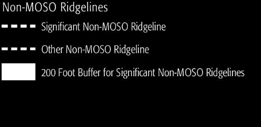
25 6. Non-MOSO Ridgeline Definition and Map Issue Description The General Plan does not contain a general ridgeline definition that applies town-wide. Do Town policies to protect ridgelines apply only to MOSO ridgelines, or apply to non-moso ridgelines in different ways? The Town needs to clarify what constitutes a ridgeline and the location of these ridgelines.
26 6. Non-MOSO Ridgeline Definition and Map Amendments: New definitions for non-moso ridgelines in General Plan and Zoning Ordinance: A Significant Non-MOSO Ridgeline means the ridgelines shown as a Significant Non-MOSO Ridgeline in General Plan Figure CD-1. An Other Non-MOSO Ridgeline means the ridgelines shown as an Other Non-MOSO Ridgeline in General Plan Figure CD-1. New General Plan Figure CD-1 shows all MOSO Ridgelines, Significant Non- MOSO Ridgelines, and Other Non-MOSO Ridgelines Significant Non-MOSO Ridgelines mapped as the centerline or crest of a ridge located outside of the MOSO Open Space designation where the crest is 800 feet or more above mean sea level, or is the continuation of a crest 800 feet or more above sea level, and constitutes a prominent landscape feature visible from public places within the surrounding area. Other Non-MOSO Ridgelines mapped as ridgelines outside of MOSO Open Space that meet these same elevation requirements and are designated as a Significant Non-MOSO Ridgeline.
27 Figure CD-1 Designated Ridgelines

28 Rheem Ridge

29 Sanders Ridge

30 Bollinger Property Add bolinger map


31 7. Protecting Ridgelines and Viewsheds Issue Description: General Plan Policy CD1.5 calls for the Town to protect ridgelines from development. It is unclear how this policy applies to ridgelines outside of MOSO Open Space, if at all. Should development be allowed on or near ridgelines outside of MOSO Open Space? If so, how should this development be designed so that it complies with Town goals and policies?
: Moraga s General Plan and Zoning Code identify several roadways in Moraga as scenic corridors.")

32 7. Protecting Ridgelines and Viewsheds Issue Description (cont.): Moraga s General Plan and Zoning Code identify several roadways in Moraga as scenic corridors. General Plan Policy CD1.3 calls for the Town to protect viewsheds along these scenic corridors. It is unclear what protect means in the context of proposed projects located in visually prominent hillside areas as viewed from scenic corridors.
33 7. Protecting Ridgelines and Viewsheds Amendments: New General Plan Goal CD8 and related policies replace existing policy CD1.5 New Zoning Ordinance Chapter (Ridgeline Protection) establishes standards for Significant Non-MOSO Ridgelines: 200-foot Buffer 35 percent visible hillside above structure and below ridgeline Exception provision if 35-percent requirement denies reasonable economic use of property Studies of different ridgeline protection standards found a strict numerical standard applied to all locations may preclude any reasonable development and/or fail to achieve the intent of maintaining an adequate visual separation between the top of homes and the ridgeline behind New standards and guidelines in Design Guidelines

34 7. Protecting Ridgelines and Viewsheds
35 7. Protecting Ridgelines and Viewsheds Amendments: Design Standards and Guidelines Replaces existing guidelines in Protect Ridgelines and Hillside Areas (RH) section of Design Guidelines Applies to hillside areas, defined as: A parcel or site with an average slope of twenty (20) percent or greater; or The area of disturbance of a proposed development project with an average predevelopment slope of twenty (20) percent or greater. Some standards and guidelines apply only to new homes and subdivisions, others also apply to additions that add an upper story to an existing home and/or increase the floor area of an existing home by 35 percent or more.
36 7. Protecting Ridgelines and Viewsheds Amendments: Design Standards and Guidelines Contains both standards and guidelines Standards: Mandatory requirements that apply to all projects. These requirements are measurable and quantitative standards similar to height, setback, and other development standards in the Zoning Code. Projects may deviate from standards only with Planning Commission approval of a Variance. Guidelines: Provide direction on the more qualitative aspects of a project and may be interpreted with some flexibility. A guideline establishes a design objective and allows for alternative approaches to achieve this objective. The Town may grant an exception to a guideline in accordance with the process described on page 7 of the Design Guidelines. Majority of new design standards and guidelines are guidelines (Discussion item)

37 7. Protecting Ridgelines and Viewsheds Example Standards RH4.1: Building Height Maximum building height: 25 feet Maximum aggregate building height: 35 feet Roof allowance: 45 feet RH4.2: Stepbacks Maximum height of down sloping vertical plane : 20 feet Step back for vertical walls above 20-foot limit: 10 feet

38 7. Protecting Ridgelines and Viewsheds Example Guidelines RH4.4: Building Mass. Building design should incorporate techniques to effectively reduce the appearance of mass, bulk and volume where visible from a public place or neighboring property. RH4.5: Roofs. Roofs should be designed to minimize the visual prominence of buildings and complement the surrounding landscape. DO THIS DON T DO THIS
39 7. Protecting Ridgelines and Viewsheds Amendments: New scenic corridor development guideline added to Section (Scenic Corridors) Buildings must be located and designed to maintain views of distant hillsides while allowing for an appropriate intensity of development consistent with the intent of the applicable zoning district and General Plan designation.

40 8. Steep Slope Limitations in MOSO Open Space Issue Description: In MOSO Open Space, development is prohibited in areas with an existing slope of 20 percent or more. MOSO Guidelines require a development "Cell" to be defined with an average grade of less than 20 percent Some applicants have calculated average slope for a very large or irregularly shaped area (a contorted cell ). Also, is development allowed in particularly high-slope areas in a cell if the average slope is less than 20 percent? Contorted Cells
41 8. Steep Slope Limitations in MOSO Open Space Amendments: In MOSO Guidelines addresses, new development envelope definition replaces the cell definition (Section II.A, page 2) and rules applying the new development envelope concept (Section II.C, page 5). Size of a development envelope limited to 10,000 square feet Each home within subdivision would have to have its own development envelope, with each required to meet the 20% slope limitation standard Streets are not included in development envelope calculation. A street is allowed if the area of disturbance to accommodate the street does not exceed an average slope of 20 percent, with no limitation on maximum size of this area.
42 9. Remediation of High Risk Areas Issue Description: Geologic hazards, such as landslides, on a hillside site can often be remediated through earthmoving, excavation, and the installation of engineering structures. MOSO Guidelines allow for reclassification of high risk areas as a result of remediation. Reclassification allows for increased residential density (up to either 1 unit per 10 acres or 1 unit per 5 acres). Should this practice of allowing increased density as a result of remediation continue?
43 9. Remediation of High Risk Areas Amendments: Amended MOSO Guidelines Section II.D.2 and General Plan policies LU1.6 and LU1.7 state that density increases are not allowed as a result of remediation Allows all types of grading in high risk areas, but not to increase density Clarifies rules for calculating permitted density for sites containing both high risk and non-high risk areas
44 10. Building Size on Large Lots Issue Description: Floor area ratio (FAR) is a measurement of the size of a building relative to its lot size. Design Guidelines establish a maximum FAR for single-family homes up to a maximum lot size of 20,000 sq. ft. Design Guidelines do not address maximum FAR for lots greater than 20,000 sq. ft.
45 10. Building Size on Large Lots Amendments: Design Guidelines Appendix D revised to specify a maximum floor area for lots greater than 20,000 square feet, allowing up to 5,500 square feet homes on a 1-acre lot. FAR and building size numbers prepared with assistance by Planning Commissioner Kovac New limits apply only to homes in a hillside area visible from a public place No quantified maximum FAR or building size standard for lots greater than 1 acre. Commissioner Kovac prepared alternative numbers producing a more natural curve allowing maximum home size of 5,100 square feet on a 1-acre lot
46 10. Building Size on Large Lots Maximum FAR and Home Size Limitations 5,500 square feet maximum home size at 1-acre lot size
47 Alternative Maximum FAR and Home Size Graph (Natural Progression to 5,100 Square Feet)
48 MORAGA HILLSIDES AND RIDGELINES PROJECT STEERING COMMITTEE MEETING, JUNE 29, 2016
-MENDOCINO COUNTY PLANNING AND BUILDING SERVICES- DIVISION II OF TITLE 20--COASTAL ZONING CODE
 CHAPTER 20.504 VISUAL RESOURCE AND SPECIAL TREATMENT AREAS Sec. 20.504.005 Applicability. Sec. 20.504.010 Purpose. Sec. 20.504.015 Highly Scenic Areas. Sec. 20.504.020 Special Communities and Neighborhoods.
Glenborough at Easton Land Use Master Plan
 Implementation 114 9.0 IMPLEMENTATION 9.1 OVERVIEW This chapter summarizes the administrative procedures necessary to implement the proposed land use plan, infrastructure improvements, development standards,
City of San Ramon. Zoning Ordinance. Adopted: October 27, Latest Revisions Effective: March 28, 2018
 City of San Ramon Zoning Ordinance Adopted: October 27, 2015 Latest Revisions Effective: March 28, 2018 City of San Ramon 7000 Bollinger Canyon Road San Ramon, California 94583 [Page intentionally left
File No (Continued)
") (Continued) Request for: (1) a Site Plan Review; (2) a Variance (to build on a significant ridgeline); (3) an Oak Tree Permit (to encroach into the protected zone of 25 oak trees and for potential thinning
(Continued) Request for: (1) a Site Plan Review; (2) a Variance (to build on a significant ridgeline); (3) an Oak Tree Permit (to encroach into the protected zone of 25 oak trees and for potential thinning
GENERAL PLAN CONSISTENCY ANALYSIS
 GENERAL PLAN CONSISTENCY ANALYSIS Prepared by Planning Staff 10/28/2013 APPLICABLE GOALS, POLICIES AND PROGRAMS FROM the LAND USE CHAPTER Goal LU-1 Policy LU-1.1 Policy LU-1.2 Goal LU-2 Protect the character
City of Lafayette Study Session Staff Report Design Review Commission
 ++ City of Lafayette Study Session Staff Report Design Review Commission Meeting Date: January 08, 2018 Staff: Subject: Chris Juram, Planning Technician SS12-17 Miramar Homebuilders, R-20 Zoning: Request
APPENDIX C: HILLSIDE DEVELOPMENT REGULATIONS (prev. Ordinance #2008-1)
") APPENDIX C: HILLSIDE DEVELOPMENT REGULATIONS (prev. Ordinance #2008-1) 1. PURPOSE: The purpose of this section is to define the conditions under which hillside development may occur that will not result
APPENDIX C: HILLSIDE DEVELOPMENT REGULATIONS (prev. Ordinance #2008-1) 1. PURPOSE: The purpose of this section is to define the conditions under which hillside development may occur that will not result
Protecting Scenic Views
 The Genesee-Finger Lakes Region is distinguished by roadway corridors and locations from which outstanding scenic views can be appreciated. Our special views encompass agricultural lands, natural areas,
ORDINANCE WHEREAS, this Ordinance is consistent with the City of Winter Garden Comprehensive Plan; and
 ORDINANCE 17-06 AN ORDINANCE OF THE CITY COMMISSION OF THE CITY OF WINTER GARDEN, FLORIDA, CREATING ARTICLE XIV OF CHAPTER 118 OF THE CITY OF WINTER GARDEN CODE OF ORDINANCES PROVIDING FOR THE EAST PLANT
Infill Residential Design Guidelines
 Infill Residential Design Guidelines Adopted March 23, 2004 Amended September 10, 2013 City of Orange Community Development Department Planning Division Phone: (714) 744-7220 Fax: (714) 744-7222 www.cityoforange.org
CHAPTER 22 Rural Open Space Community Developments
 CHAPTER 22 Rural Open Space Community Developments Section 22.1 Description and Purpose The intent of this Chapter is to offer property owners an alternative to traditional zoning requirements for rural
Zoning Ordinance Chapter 10
 CHAPTER 10 - WASHES SECTION 10.0 GENERAL: A. The purpose of this Ordinance is to establish standards for development in or near Major and Minor Washes as defined in Appendix A Glossary of Terms and Definitions
Town of Washington Master Plan & Regulatory Audit: Interim Results
 Town of Washington Master Plan & Regulatory Audit: Interim Results May 20, 2008 Presented by: 30 Bank Street Lebanon, NH 03766 www.uvlsrpc.org Introduction & Purpose Compare the Master Plan to the regulations
CITY OF SCANDIA ORDINANCE NO. 174
 CITY OF SCANDIA ORDINANCE NO. 174 AN ORDINANCE AMENDING ORDINANCE NO. 122, THE SCANDIA DEVELOPMENT CODE, CHAPTER 2, SECTION 4.34, REGARDING SOLAR FARMS AND COMMUNITY SOLAR GARDENS The City Council of the
PLANNING COMMISSION AGENDA REPORT APRIL 7, 2016
 PLANNING COMMISSION AGENDA REPORT APRIL 7, 2016 TO: FROM: Members of the Planning Commission Talyn Mirzakhanian, Senior Planner FILE NO.: 160001710 PROPOSAL: APPLICANT: RECOMMENDATION: A request for a
A. General Plan: Land Use, Growth Management and the Built Environment Element. d. Use visually unobtrusive building materials.
 Chapter 16 Hillside Protection 16.010 Purpose This chapter establishes the regulations for development and alteration of properties in hillside and ridgeline areas in order to preserve the essential scenic
APPENDIX A 6 CONCEPTUAL PRELIMINARY PLAN GUIDE AND CHECKLIST FOR MAJOR SUBDIVISIONS CARRBORO DEVELOPMENT GUIDE APPENDIX A
 6 CONCEPTUAL PRELIMINARY PLAN GUIDE AND CHECKLIST FOR MAJOR SUBDIVISIONS Conceptual Preliminary Guide/Checklist for Major Subdivisions Page 1 FORM: REVIEW DATE: CONCEPTUAL PLAN REVIEW 2000 REVIEWED BY:
I. STAFF POLICY RECOMMENDATIONS. The following RMP policy strategies are proposed by staff in support of a Scenic Resource Protection Program:
 Policy Consideration: Scenic Resource Protection Program Status: For Consideration by the Highlands Council at September 14, 2006 Work session Date: September 12, 2006 I. STAFF POLICY RECOMMENDATIONS The
OCEAN BOULEVARD PLANNED DEVELOPMENT DISTRICT (PD-5)
") OCEAN BOULEVARD PLANNED DEVELOPMENT DISTRICT (PD-5) Ordinance History: C-5562, 1982 The intent of the Planned Development Plan is to provide a framework to guide new development in a way that is sensitive
OCEAN BOULEVARD PLANNED DEVELOPMENT DISTRICT (PD-5) Ordinance History: C-5562, 1982 The intent of the Planned Development Plan is to provide a framework to guide new development in a way that is sensitive
Town of Portola Valley General Plan. Nathhorst Triangle Area Plan
 Town of Portola Valley General Plan Amended December 10, 1997 Table of Contents Introduction... 1 Planning Area... 1 Objectives... 2 Principles... 2 Standards... 4 Description... 4 Community Commercial...
THE CITY COUNCIL OF THE CITY OF SAN JUAN BAUTISTA DOES HEREBY ORDAIN AS FOLLOWS:
 ORDINANCE NO. 2016 01 AN ORDINANCE OF THE CITY OF SAN JUAN BAUTISTA AMENDING THE SAN JUAN BAUTISTA MUNICIPAL CODE TO ADD CHAPTER 11-08 HILLSIDE DEVELOPMENT REGULATIONS WHEREAS, the City Council has reviewed
City of Lafayette Study Session Staff Report Design Review Commission
 City of Lafayette Study Session Staff Report Design Review Commission Meeting Date: April 24, 2017 Staff: Payal Bhagat, Senior Planner Subject: HDP18-15 & HDP31-15 Ramesh Patel & Melcor Development (Owners),
Exhibit A. 8:9 Scuffletown Rural Conservation District
 Exhibit A 8:9 Scuffletown Rural Conservation District 8:9.1 Intent and Purpose The Scuffletown Rural Conservation (SRC) District is intended to provide for residential development that supports the development
Chapter Master Planned Communities (MPC) District
 District") Sections 14.53.010 Purpose and Intent 14.53.020 Applicability 14.53.030 Procedure 14.53.040 MPC Standards 14.53.050 Required Findings 14.53.010 Purpose and Intent Chapter 14.53 Master Planned Communities
Sections 14.53.010 Purpose and Intent 14.53.020 Applicability 14.53.030 Procedure 14.53.040 MPC Standards 14.53.050 Required Findings 14.53.010 Purpose and Intent Chapter 14.53 Master Planned Communities
PARK CITY MUNICIPAL CODE TABLE OF CONTENTS TITLE 15 LAND MANAGEMENT CODE - CHAPTER 2.21
 PARK CITY MUNICIPAL CODE TABLE OF CONTENTS TITLE 15 LAND MANAGEMENT CODE - CHAPTER 2.21 TITLE 15 - LAND MANAGEMENT CODE CHAPTER 2.21 - SENSITIVE LAND OVERLAY ZONE (SLO) REGULATIONS 15-2.21-1. PURPOSE...1
Planning Commission Staff Report June 5, 2008
 Owner/Applicant Taylor Village Sacramento Investments Partners, LP c/o Kim Whitney 1792 Tribute Road #270 Sacramento, CA 95815 Staff Recommendation Planning Commission Staff Report Project: File: Request:
Baseline Hillside Project Kick-Off Meetings. February 2009
 Baseline Hillside Project Kick-Off Meetings February 2009 Regional Topography With Community Plan Boundaries The darker the great, the steeper the slope Purpose of Meeting Get everyone up to speed. Show
ORDINANCE NO N.S.
 ORDNANCE NO. 1035 N.S. A ORDNANCE OF THE CTY COUNCL OF THE CTY OF EL PASO DE ROBLES APPROVNG RESDENTAL GRADNG ORDNANCE AMENDMENT/ ZONE CHANGE 15-005 APPLCANT - CTY OF PASO ROBLES 2016 GRADNG ORDNANCE AMENDMENT
PC RESOLUTION NO
 PC RESOLUTION NO. 14-01-14-02 TENTATIVE TRACT MAP fttm) 17441. REZONE {RZ) 13-003, ARCHITECTURAL CONTROL (AC) 13-003, TREE REMOVAL PERMIT (TRP) 13-052. GRADING PLAN MODIFICATION (GPM) 13-002. CONDITIONAL
Procedures IV. V. Rural Road Design Option
 i IV. Procedures A. All applicants required to prepare a Conservation Design Subdivision shall provide the Planning Board with a conceptual conventional subdivision design as well as a proposed layout
Conservation Development
 Acknowledgements RIDEM: Scott Millar Anthony Lachowicz-Planning and Zoning Consultant Director of Planning 1 : a creative land use technique that allows a community to guide growth to the most appropriate
City of Lafayette Staff Report
 City of Lafayette Staff Report For: By: Design Review Commission Greg Wolff, Senior Planner Meeting Date: April 27, 2015 Subject: SS03-15 Gundi & Peter Younger (Owners), R-40 Zoning: Request for a Study
Sheridan Joint Planning Area Land Use Plan. Adopted 2017
 Sheridan Joint Planning Area Land Use Plan Adopted 2017 The JPA Land Use Plan was completed with substantial public input and under the direction of the city and county planning commissioners, City Council,
Essential Skills: Reading and Interpreting Maps and Plans
 Essential Skills: Reading and Interpreting Maps and Plans Prepared for: NYS Tug Hill Commission Local Government Conference March 31, 2016 Prepared by: Peter G. Vars, P.E. BME ASSOCIATES Stages of Plan
Planned Development Review Revisions (Project No. PLNPCM )
") Planned Development Review Revisions (Project No. PLNPCM2014-00139) Standard residential development Planned Development Example: Smaller lot sizes than what is allowed to create open space amenity. What
Planned Development Review Revisions (Project No. PLNPCM2014-00139) Standard residential development Planned Development Example: Smaller lot sizes than what is allowed to create open space amenity. What
ORDINANCE NO WHEREAS, the City of Kalama has many areas of timberland and open areas inside its City limits adjacent to residential areas;
 ORDINANCE NO. 1342 AN ORDINANCE OF THE CITY OF KALAMA, WASHINGTON ADOPTING A NEW KALAMA MUNICIPAL CODE CHAPTER 17.20 ESTATE LOT FLOATING ZONE TO PROVIDE TRANSITIONAL ZONING OPTIONS FOR RESIDENTIAL DEVELOPMENT
Example Codes. City of Brentwood, Tennessee Brentwood Hillside Protection Overlay District Summary
 Example Codes City of Brentwood, Tennessee Brentwood Hillside Protection Overlay District Summary The City of Brentwood in July 2007 adopted a Hillside Protection (HP) Overlay District to address the problems
CHAPTER 4 - LAND USE CLASSIFICATIONS
 CHAPTER 4 - LAND USE CLASSIFICATIONS Four new land use classification categories are established in the Gualala Town Plan: Gualala Village Mixed Use; Gualala Highway Mixed Use; Gualala Planned Development
PART 1: PROJECT SUMMARY. The application is Attachment A. The site plan is Attachment B.
 Belleterre Subdivision Sketch Plan Town Board 8.7.17 Belleterre Subdivision Sketch Plan PART 1: PROJECT SUMMARY Applicant: Bowman Development Project Size: +/- 20.85 acres Parcel Number: 01115104 and 01115121
ZONING AMENDMENT, PLANNED UNIT DEVELOPMENT & SUBDIVISION STAFF REPORT Date: March 20, 2008
 ZONING AMENDMENT, PLANNED UNIT DEVELOPMENT & SUBDIVISION STAFF REPORT Date: March 20, 2008 NAME SUBDIVISION NAME LOCATION Joseph Mramor Mramor s Addition to Weinacker Avenue Subdivision 900 Weinacker Avenue
APPROVED WITH CONDITIONS
 Provo City Planning Commission Report of Action October 26, 2016 ITEM 10 Provo City Parks and Recreation Department requests a variance to the Sensitive Lands Ordinance to grade within a hillside of 30%
City of Lafayette Study Session Project Data
 City of Lafayette Study Session Project Data For: Design Review Commission By: Michael P. Cass, Senior Planner Date: August 24, 2015 Property Address: 954 Mountain View Drive APN: 243-070-011 Zoning District:
INTRODUCTION INTRODUCTION 1-1
 1 INTRODUCTION INTRODUCTION 1-1 This Chapter presents an introduction to the Design Standards and Guidelines document and provides guidance regarding the application of the Design Standards and Guidelines.
SECTION 5 - SCENIC HIGHWAYS
 SECTION 5 - SCENIC HIGHWAYS INTRODUCTION The California State Scenic Highways Program was established by the State Legislature through Senate Bill No. 1467 (Farr) in 1963. This Bill established the Scenic
CITY OF CYPRESS 5275 Orange Avenue Cypress, California (714) DESIGN REVIEW COMMITTEE PERMIT PROCESS
 DESIGN REVIEW COMMITTEE PERMIT PROCESS") CITY OF CYPRESS 5275 Orange Avenue Cypress, California 90630 (714) 229-6720 DESIGN REVIEW COMMITTEE PERMIT PROCESS 1. Discuss project with Planning staff to determine zoning regulations, any unusual characteristics
CITY OF CYPRESS 5275 Orange Avenue Cypress, California 90630 (714) 229-6720 DESIGN REVIEW COMMITTEE PERMIT PROCESS 1. Discuss project with Planning staff to determine zoning regulations, any unusual characteristics
City of Lafayette Staff Report
 City of Lafayette Staff Report For: By: Design Review Commission Greg Wolff, Senior Planner Meeting Date: November 25, 2013 Subject: L03-11 O BRIEN LAND CO., LLC (APPLICANT), AMD FAMILY TRUST (OWNER),
MASTER PLAN. 201 Planning Concepts. Chapter 2
 Chapter 2 MASTER PLAN 201 Planning Concepts 202 Master Land Use Plan 203 Affordable Housing Program 204 Parks, Open Space, and Recreation Trails 205 Grading Concept 206 Circulation Plan 207 Landscape Concept
COMPLIANCE CHECKLIST HILLSIDE RESIDENTIAL DESIGN GUIDELINES MANUAL
 COMPLIANCE CHECKLIST HILLSIDE RESIDENTIAL DESIGN GUIDELINES MANUAL The following checklist summarizes development guidelines and standards. See the appropriate section for a complete explanation of the
Asbury Chapel Subdivision Sketch Plan
 Asbury Chapel Subdivision Sketch Plan PART 1: PROJECT SUMMARY Applicant: NVR Inc. Project Size: +/- 76.13 acres Parcel Numbers: 02101112,02116101,02116112, 02116113 Current Zoning: Transitional Residential
IV.B. VISUAL RESOURCES
 IV.B. VISUAL RESOURCES ENVIRONMENTAL SETTING Existing Visual Character Project Site The project site is located at 17331-17333 Tramonto Drive in the Pacific Palisades community of the City of Los Angeles
LANDSCAPE GUIDELINES. Countryside & Coastal Countryside Environments. Landscape, Natural Character & Amenity Values Guide
 Landscape, Natural Character & Amenity Values Guide Copyright WDC 2009 Version A2 18May09 Environmental Services Group Publication Countryside & Coastal Countryside Environments START HERE Quality Land
ROLL CALL Member Anthony, Member Avdoulos, Member Greco, Member Lynch, Member Maday, Chair Pehrson
 CALL TO ORDER The meeting was called to order at 7:00 PM. PLANNING COMMISSION ACTION SUMMARY CITY OF NOVI Regular Meeting July 11, 2018 7:00 PM Council Chambers Novi Civic Center 45175 W. Ten Mile (248)
SUBDIVISION, PLANNED UNIT DEVELOPMENT, PLANNING APPROVAL, REZONING & SIDEWALK WAIVER STAFF REPORT Date: February 7, 2013
 SUBDIVISION, PLANNED UNIT DEVELOPMENT, PLANNING APPROVAL, REZONING & SIDEWALK WAIVER STAFF REPORT Date: February 7, 2013 APPLICANT NAME SUBDIVISION NAME DEVELOPMENT NAME LOCATION S. E. Cemeteries of AL
Town of Liberty, NY COMPREHENSIVE PLAN & ZONING UPDATES
 Town of Liberty, NY S Public Informational Meeting October 4, 2016 High School Auditorium Welcome Thank you for coming tonight. Agenda Part I Overview of Proposed Changes What is Being Prepared Anticipated
Port Marigny TND Planning and Zoning Commission Workshop September 1, 2015 Preliminary Observations - David Bailey, AIA, AICP
 Planning and Zoning Commission Workshop September 1, 2015 Preliminary Observations - David Bailey, AIA, AICP Outline, per 8-27-15 Memorandum: 1. Background 2. General Observations 3. Comprehensive Plan
ARTICLE VI AGRICULTURAL PROTECTION DISTRICT
 A. Findings and Purpose ARTICLE VI AGRICULTURAL PROTECTION DISTRICT The Town of Northumberland finds that the protection of agriculture is essential to the implementation of the goals and objectives ofthe
SENSITIVE LANDS OVERLAY
 SENSITIVE LANDS OVERLAY Chapter 22 Sensitive Lands Overlay 22.1 PURPOSE 22.2 APPLICATION AND ANALYSIS REQUIREMENTS 22.3 SENSITIVE LAND REGULATIONS 22.4 ADMINISTRATIVE PROVISIONS 22.5 DESIGN STANDARDS 22.6
Chapter 5: Natural Resources and Environment
 NATURAL RESOURCES AND ENVIRONMENT 5-1 5 Chapter 5: Natural Resources and Environment BACKGROUND AND INTENT Urban expansion represents the greatest risk for the future degradation of existing natural areas,
Narcoossee Roadway Corridor
 Community Meeting Narcoossee Roadway Corridor April 5, 2012 Meeting Agenda Purpose of Meeting Continuation of Study Update Process (Previous Meetings Oct. & Nov., 2011) Tonight s Objective Review Proposals
#8) T-1409 CENTENNIAL & LAMB TENTATIVE MAP
 T-1409 CENTENNIAL & LAMB TENTATIVE MAP") #8) T-1409 CENTENNIAL & LAMB TENTATIVE MAP STAFF REPORT To: Planning Commission Meeting Date: June 14, 2017 Item: T-1409 Prepared By: Robert Eastman GENERAL INFORMATION: Applicant: Property Owner(s): Requested
#8) T-1409 CENTENNIAL & LAMB TENTATIVE MAP STAFF REPORT To: Planning Commission Meeting Date: June 14, 2017 Item: T-1409 Prepared By: Robert Eastman GENERAL INFORMATION: Applicant: Property Owner(s): Requested
Innovative Land Use Techniques
 Innovative Land Use Techniques A Handbook for Sustainable Development Eric Williams, Assistant Administrator, NHDES Carolyn Russell, Principal Planner, NHDES Cliff Sinnott, Executive Director, RPC Jill
PART 1: PROJECT SUMMARY. Proposed Land Use: 120 single-family lots. The application is Attachment A. The site plan is Attachment B.
 PART 1: PROJECT SUMMARY Applicant: JBH Development, LLC and Hopper Communities, INC Project Size: +/- 80.48 acres Parcel Number: 01513107, 01513108, 01513109, 01513113, 01513120, 01513121, 01513122, 01513124,
O l so n M e morial Highway, S t e , G o l d e n V a l l e y, MN Delano Laketown Homes Concept Plan
 N O R T H W E S T A S S O C I A T E D C O N S U L T A N T S, I N C. 4 1 5 0 O l so n M e morial Highway, S t e. 3 2 0, G o l d e n V a l l e y, MN 5 5 4 2 2 T e l e p h o n e : 7 6 3. 9 5 7. 1 1 0 0 W
Policies and Code Intent Sections Related to Town Center
 Policies and Code Intent Sections Related to Town Center The Town Center Vision is scattered throughout the Comprehensive Plan, development code and the 1994 Town Center Plan. What follows are sections
ZONING AMENDMENT & PLANNED UNIT DEVELOPMENT STAFF REPORT Date: April 4, 2013
 ZONING AMENDMENT & PLANNED UNIT DEVELOPMENT STAFF REPORT Date: April 4, 2013 NAME DEVELOPMENT NAME LOCATION DIP Exchange, LLC DIP Exchange, LLC 93 Sidney Phillips Drive (West side of Sidney Phillips Drive,
Draft Gaviota Coast Plan Chapter 7: Visual Resources
 Draft Gaviota Coast Plan Chapter 7: Visual Resources 11/28/2012 Long Range Planning Division Planning and Development Department County of Santa Barbara Page Intentionally Blank Cover Photo: Gaviota Morning
LAND USE ELEMENT. Purpose. General Goals & Policies
 LAND USE ELEMENT Purpose This Land Use Element contains the goals and policies necessary to support the City s responsibility for managing land resources and guiding development through implementing regulations,
Attachment 4. TRPA Environmental Documentation, IEC/MFONSE
 Required Findings for Certification of the Final Initial Study/Mitigated Negative Declaration (IS/MND) and Initial Environmental Checklist/Mitigated Finding Of No Significant Effect (IS/MFONSE) TRPA Environmental
Site Design (Table 2) Fact Sheet & Focus Questions:
 Fact Sheet & Focus Questions:") Site Design (Table 2) Fact Sheet & Focus Questions: BACKGROUND WHAT IS SITE DESIGN? Site design refers to the arrangement of buildings and open spaces on adjacent sites to maximize the shared benefits
Site Design (Table 2) Fact Sheet & Focus Questions: BACKGROUND WHAT IS SITE DESIGN? Site design refers to the arrangement of buildings and open spaces on adjacent sites to maximize the shared benefits
RECEIVED MAY TOWN OF LOS GATOS PLANNING DIVISION
 ANTHONY j. BADAME, M.D. Diplomate American Board of Dermatology May 31, 2016 RECEIVED MAY 3 1 2016 TOWN OF LOS GATOS PLANNING DIVISION 2025 Forest Avenue, Suite 9 San Jose, California 95128 Telephone:
LU Encourage schools, institutions, and other community facilities that serve rural residents to locate in neighboring cities and towns.
 Application No. 891627: Comprehensive Plan Text Amendment - Rural School Policies - Amend policies consistent with State Legislation allowing schools in the rural area and extension of sewer service to
LIST OF TABLES, FIGURES AND APPENDICES
 LIST OF TABLES, FIGURES AND APPENDICES Chapter Page 2 INTERPRETATION FIGURE 2.1 SAMPLE AWNING...2.8 FIGURE 2.2 SAMPLE LOW-RISE APARTMENT DESIGN...2.9 FIGURE 2.3 SAMPLE DUPLEX DESIGN...2.10 FIGURE 2.4 SAMPLE
CHUGIAK-EAGLE RIVER SITE-SPECIFIC LAND USE PLAN
 CHUGIAK-EAGLE RIVER SITE-SPECIFIC LAND USE PLAN JUNE 2010 Final Prepared for The Heritage Land Bank, Municipality of Anchorage by Agnew: :Beck Consulting www.agnewbeck.com 907.222.5424 Chugiak-Eagle River
DISCUSSION ON VACAVILLE S2 INVESTORS PROPERTY IN URBAN RESERVE
 Agenda Item No. 9C April 25, 2017 TO: FROM: SUBJECT: Honorable Mayor and City Council Attention: Jeremy Craig, Interim City Manager Barton Brierley, AICP, Community Development Director (Staff Contact:
APPENDIX C. Architectural and Environmental Design Standards. Environmentally sensitive areas should be protected.
 APPENDIX C Architectural and Environmental Design Standards Environmentally Sensitive Areas Goal A. Environmentally sensitive areas should be protected. Development, such as roads, houses, and other structures,
The broad range of permitted and special uses allowed in the district remain, but some descriptions have been clarified.
 Memorandum To: Emily Fultz, AICP City Planner, City of Edwardsville From: Michael Blue, FAICP Principal, Teska Associates Date: January 24, 2019 RE: B-1 Zoning District Update A draft, updated B-1 Central
Planning Academy MARCH 8, 2015
 Planning Academy MARCH 8, 2015 Overview of Growth Management in Albemarle County Comprehensive Plans, Planning Initiatives Major Milestones Key Policies History Comprehensive Plan should precede Zoning
TEN MILE PLANNING COMMISSION AGENDA January 10, :30 p.m. Buffalo Mountain Meeting Room, County Commons 0037 Peak One Dr., SCR 1005, Frisco, CO
 PLANNING DEPARTMENT 970.668.4200 0037 Peak One Dr. PO Box 5660 www.summitcountyco.gov Frisco, CO 80443 TEN MILE PLANNING COMMISSION AGENDA January 10, 2019-5:30 p.m. Buffalo Mountain Meeting Room, County
CITY OF ZEELAND PLANNING COMMISSION
 APPLICATION FOR SITE PLAN REVIEW AND SPECIAL LAND USE Date City Official App. Filing Fee Rec'd ($350) NOTE TO APPLICANT: Please submit this application for Site Plan Review along with twenty (20) copies
Watertown City Council
 City of Watertown Watertown City Council April 14 th, 2015 Agenda Item: City Comment on Sun Share CUP Application Request for Action: Motion to Approve City Comments regarding CUP Application Department:
SAN RAFAEL GENERAL PLAN 2040 INTRODUCTION AND OVERVIEW
 SAN RAFAEL GENERAL PLAN 2040 INTRODUCTION AND OVERVIEW Steering Committee Presentation February 14, 2018 Purpose of General Plan Guide land use and development decisions Coordinate transportation, infrastructure,
PLANNING COMMISSION AGENDA REPORT SEPTEMBER 1, 2016
 PLANNING COMMISSION AGENDA REPORT SEPTEMBER 1, 2016 TO: Members of the Planning Commission FROM: Michael Klein, Planner FILE NO.: 150000780 PROPOSAL: APPLICANT: RECOMMENDATION: A request for a Site Plan
3.10 LAND USE SETTING PROJECT SITE EXISTING LAND USE DESIGNATIONS AND ZONING. General Plan Land Use Designations.
 This section of the Draft EIR addresses the existing land uses on and adjacent to the project site and discusses the potential impacts of the proposed project on existing land uses. Key issues addressed
2.0 AREA PLANS. Lakeside Business District. Lakeside Business District Land Use Categories:
 Lakeside Business District Lakeside Business District Land Use Categories: Campus Commercial Campus Commercial means a mixture of uses which includes corporate offices, office parks, hotels, commercial,
IV. Development in the Rural Overlay District
 Intracoastal Waterway Route 17 Route 168 Great Dismal Swamp VIRGINIA NORTH CAROLINA IV. Development in the Rural Overlay District IV-1 Route 17 in Chesapeake s Rural Overlay District affords distant views
36.1. PURPOSE APPLICABILITY DESIGN REVIEW GUIDELINES
 CHAPTER 36: DESIGN STANDARDS 36.1. PURPOSE The purpose of this chapter is to ensure that projects are designed and constructed consistent with the Community Design Subelement of the Land Use Element and
Environmental Protection Ordinances (Performance Zoning) Bedminster Township, Bucks County
 Bedminster Township, Bucks County") Environmental Protection Ordinances (Performance Zoning) Bedminster Township, Bucks County ARTICLE VI. PERFORMANCE STANDARDS Section 600 Compliance All uses, activities, subdivisions and/or land developments
Environmental Protection Ordinances (Performance Zoning) Bedminster Township, Bucks County ARTICLE VI. PERFORMANCE STANDARDS Section 600 Compliance All uses, activities, subdivisions and/or land developments
VIRGINIA DRIVE SPECIAL PLAN
 August 15, 2017 Staff Report to the Municipal Planning Board CASE #GMP2017-10006 & LDC2017-00231 Item # 7 VIRGINIA DRIVE SPECIAL PLAN Location Map Subject Site SUMMARY Applicant City of Orlando, Planning
4.1 LAND USE AND HOUSING
 4.1 This section provides a project-level analysis of potential impacts to land use, Shorelines of the State (shorelines), and housing. The study area for the land use and housing analysis in the Final
ARTICLE 6: Special and Planned Development Districts
 ARTICLE 6: Special and Planned Development Districts 6-10 Traditional Neighborhood Development (TND) District 6-10.10 Purpose and Intent The Traditional Neighborhood Development (TND) District provides
OFFICE CONSOLIDATION SECONDARY PLAN AREA 22 THE BRAMALEA SOUTH INDUSTRIAL SECONDARY PLAN
 OFFICE CONSOLIDATION SECONDARY PLAN AREA 22 THE BRAMALEA SOUTH INDUSTRIAL SECONDARY PLAN November 2010 EXPLANATORY NOTES (Secondary Plan Area 22) General (pertaining to all secondary plan office consolidations)
2 STATUTORY PUBLIC MEETING AND INFORMATION REPORT FOR PUBLIC MEETING ON AMENDMENT NO. 62 TO THE YORK REGION OFFICIAL PLAN
 2 STATUTORY PUBLIC MEETING AND INFORMATION REPORT FOR PUBLIC MEETING ON AMENDMENT NO. 62 TO THE YORK REGION OFFICIAL PLAN Pursuant to Section 17(15) of the Planning Act, as amended, the Regional Planning
FORMER STECK PHILBIN LANDFILL Old Northport Rd, Kings Park, NY 11754
 FORMER STECK PHILBIN LANDFILL Old Northport Rd, Kings Park, NY 11754 Tax Map# 0800-042.00-01.00-001.000 0800-042.00-01.00-002.002 This is an approximately 24.90 acre site, which consists of two contiguous
Chapter PEDESTRIAN COMMERCIAL (PC) ZONING DISTRICT
 ZONING DISTRICT") Chapter 11-17 PEDESTRIAN COMMERCIAL (PC) ZONING DISTRICT Sections: 11-17-01 GENERAL PURPOSE 11-17-02 PERMITTED BUILDING TYPES 11-17-03 USES PERMITTED WITH DESIGN REVIEW 11-17-04 USES PERMITTED BY CONDITIONAL
Chapter 11-17 PEDESTRIAN COMMERCIAL (PC) ZONING DISTRICT Sections: 11-17-01 GENERAL PURPOSE 11-17-02 PERMITTED BUILDING TYPES 11-17-03 USES PERMITTED WITH DESIGN REVIEW 11-17-04 USES PERMITTED BY CONDITIONAL
ORDINANCE AN ORDINANCE TO ADD A NEW SECTION 4.N. IN THE ZONING CODE FOR THE TOWN OF MIDDLETOWN, RELATING TO MIXED-USE DEVELOPMENT
 Introduced: November 5, 2018 Approved: ORDINANCE 18-11-01 AN ORDINANCE TO ADD A NEW SECTION 4.N. IN THE ZONING CODE FOR THE TOWN OF MIDDLETOWN, RELATING TO MIXED-USE DEVELOPMENT BE IT ENACTED BY THE MAYOR
PLANNING COMMISSION AGENDA REPORT NOVEMBER 15, 2012
 PLANNING COMMISSION AGENDA REPORT NOVEMBER 15, 2012 TO: FROM: Members of the Planning Commission Michael Klein, Associate Planner FILE NO.: 120000890 PROPOSAL: APPLICANT: Request for an Administrative
SECTION E. Realizing the Plan
 SECTION E Realizing the Plan 60 DESIGN REGINA - OFFICIAL COMMUNITY PLAN SECTION E Realizing the Plan Design Regina has been an ambitious plan-making exercise, with a high level of community, stakeholder,
Authority of the General Plan
 Authority of the General Plan This La Habra Heights General Plan will serve as the blueprint for future planning and development in the City. This General Plan describes the City s vision for the future
Location and Field Inspection: History: Master Plan Recommendation:
 R E S O L U T I O N WHEREAS, the Prince George s County Planning Board has reviewed Special Permit Application No. SP-130008, Sudsville Laundry, requesting a special permit to construct an addition and
CHAPTER FIVE COMMUNITY DESIGN
 CHAPTER FIVE COMMUNITY DESIGN CHAPTER FIVE - COMMUNITY DESIGN Assumptions Frazier Park and Lebec have historically developed according to different patterns of spatial form. While both communities are