connecting communities
|
|
|
- Justina Roberts
- 5 years ago
- Views:
Transcription

1 OUR GREATER SYDNEY 2056 Western City District Plan connecting communities March 2018 Updated

2 2 Acknowledgement of Country The Greater Sydney Commission acknowledges the traditional owners of the lands that include Western City District and the living culture of the traditional custodians of these lands. The Commission recognises that the traditional owners have occupied and cared for this Country over countless generations, and celebrates their continuing contribution to the life of Greater Sydney. Western City District Blue Mountains Camden Campbelltown Fairfield Hawkesbury Liverpool Penrith Wollondilly Greater Sydney Commission Draft Western City District Plan


3 3 Foreward Chief Commissioner Lucy Hughes Turnbull AO I am delighted to present the Western City District Plan, which sets out planning priorities and actions for improving the quality of life for residents as the district grows and changes. The Plan recognises what the Greater Sydney Commission has heard particularly that the District s natural landscape is a great asset and attractor, sustaining and supporting a unique, parkland city. This Plan complements those natural assets, and it puts people first. It leverages the transformative, economic improvements from the Western Sydney Airport and considers the transport, infrastructure, services, affordable housing and open spaces that will be required as the population grows and the demographics change. Also, it considers community and cultural life and the environmental sustainability of the landscape. Collaboration is the key to transparent and informed decision-making on our city s future growth. The Greater Sydney Commission will continue to bring together all parties with an interest in the District s future and channel the collective energy into improved planning outcomes. By taking a leadership role, we are bringing together public resources and expertise to create a more liveable, productive and sustainable city. Finally, on behalf of the Greater Sydney Commission, I acknowledge the important work of councils whose submissions and feedback on the needs of their neighbourhoods and centres have been invaluable. Together with the community and other stakeholders, your expertise and interest have helped to produce an inspiring and practical plan. Interim Western City District Commissioner Geoff Roberts The Western City District is Greater Sydney s parkland city, a place surrounded by World Heritage Listed landscapes, with a sprinkling of towns and centres that combine village charm and heritage character. This iconic landscape is more than a backdrop it is the District s underlying asset. People travel from around the world to experience the mountains, escarpments, rural hinterland and rivers. The landscape is the foundation for how we plan for the District it resonates in our places and informs the District s design and structure. The development of Australia s first 21st century international airport will drive population growth, improve transport links and create new jobs and economic opportunities. This is a unique chance to grow new markets in international and domestic tourism, advanced logistics, aerospace industries freight, transport, health, education and the knowledge economy. The Western Sydney City Deal between the Australian, the NSW Governments and local governments will drive this growth. With such change, the Western City District Plan works to protect and enhance the character of our places and make it easier for residents to access services and facilities. With more jobs, more residents will be working locally and experiencing shorter commutes. To support this, we will work towards a greater diversity of homes so that people can afford to live here and can choose a home that better suits their lifestyle. This Plan is part of a continuing conversation about how we can come together to create the District we aspire to. I m eager for as many people as possible to get involved as we implement the Plan. It s an important step in helping to shape the decisions that will drive the District s future. Greater Sydney Commission Draft Western City District Plan
4 4 Contents Future of the Western City District 6 3 Liveability 26 Metropolitan context of the Western City District 8 Structure Plan for the Western City District 10 Ten Directions for a metropolis of the three cities and the Western City District 14 1 About the Plan 16 2 Infrastructure and collaboration 18 Planning Priority W1. Planning for a city supported by infrastructure 20 Planning Priority W2. Working through collaboration 22 Planning Priority W3. Planning Priority W4. Planning Priority W5. Planning Priority W6. Providing services and social infrastructure to meet people s changing needs 28 Fostering healthy, creative, culturally rich and socially connected communities 33 Providing housing supply, choice and affordability, with access to jobs, services and public transport 39 Creating and renewing great places and local centres, and respecting the District s heritage 48 4 Productivity 56 Planning Priority W7. Establishing the land use and transport structure to deliver a liveable, productive and sustainable Western Parkland City 60 Planning Priority W8. Leveraging industry opportunities from the Western Sydney Airport and Badgerys Creek Aerotropolis 71 Planning Priority W9. Growing and strengthening the metropolitan cluster 78 Planning Priority W10. Maximising freight and logistics opportunities and planning and managing industrial and urban services land 87 Planning Priority W11. Growing investment, business opportunities and jobs in strategic centres 94 Greater Sydney Commission Draft Western City District Plan

5 5 5 Sustainability 104 Planning Priority W12. Planning Priority W13. Planning Priority W14. Planning Priority W15. Planning Priority W16. Protecting and improving the health and enjoyment of the District s waterways 108 Creating a Parkland City urban structure and identity, with South Creek as a defining spatial element 113 Protecting and enhancing bushland and biodiversity Increasing urban tree canopy 116 cover and delivering Green Grid connections 119 Protecting and enhancing scenic and cultural landscapes Planning Priority W17. Better managing rural areas 125 Planning Priority W18. Delivering high quality open space 128 Planning Priority W19. Reducing carbon emissions and 124 managing energy, water and waste efficiently 132 Planning Priority W20. Adapting to the impacts of urban and natural hazards and climate change Implementation 140 Planning Priority W21. Preparing local strategic planning statements informed by local strategic planning 143 Planning Priority W22. Monitoring and reporting on the delivery of the plan Endnotes 148 Refer to inside back cover for amendment notes to this Plan. Greater Sydney Commission Draft Western City District Plan


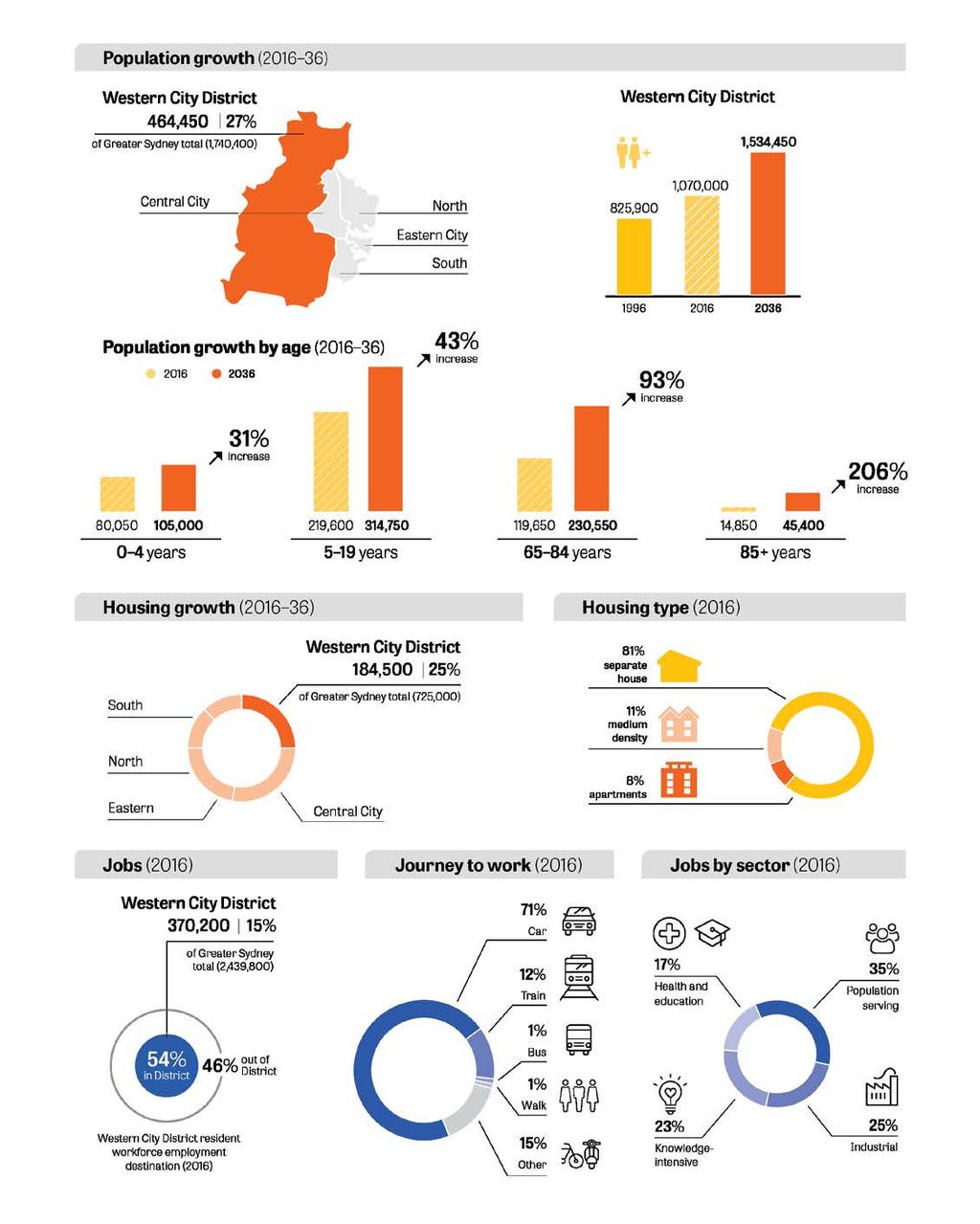
6 6 Future of the Western City District The vision for Greater Sydney as a metropolis of three cities the Western Parkland City, the Central River City and the Eastern Harbour City and a 30-minute city means residents in the Western City District will have quicker and easier access to a wider range of jobs, housing types and activities. This vision will improve the District s lifestyle and environmental assets. This will be achieved by: Creating a once-in-a-generation economic boom with the Western Sydney Airport and Badgerys Creek Aerotropolis bringing together infrastructure, businesses and knowledge-intensive jobs Building on the Western Sydney City Deal to transform the Western City District over the next 20 to 40 years by building on natural and community assets and developing a more contained Western City District with a greater choice of jobs, transport and services aligned with growth Delivering the first stage of the North South Rail Link Collaborating and building strong relationships between Liverpool, Greater Penrith and Campbelltown-Macarthur reinforced by the emerging Badgerys Creek Aerotropolis forming a unique metropolitan cluster Providing major transport links for people and freight by unprecedented transport investments Developing a range of housing, providing access to public transport and infrastructure including schools, hospitals and community facilities Linking walking and cycling paths, bushland and a green urban landscape framed by the Greater Blue Mountains World Heritage Area, the Scenic Hills and Western Sydney Parklands Enhancing and protecting South Creek, Georges River and Hawkesbury- Nepean river systems Mitigating the heat island effect and providing cooler places by extending urban tree canopy and retaining water in the landscape Protecting the District s natural landscapes, heritage and tourism assets, unique rural areas and villages Protecting the environmental, social and economic values of the Metropolitan Rural Area.


7 Connecting 7 Communities Protected Natural Area Greater Blue Mountains World Heritage Area State Conservation areas: Burragorang, Yerranderie and Nattai Drinking water catchments Metropolitan Rural Area Includes primary production and resource extraction, tourism and recreation assets, towns and villages Strategic Centres at Richmond Windsor and Katoomba Western Economic Corridor Jobs growth leveraging the investment in infrastructure and new communities Greater Penrith to Eastern Creek Growth Area Integrated land use and transport planning to optimise north-south links South Creek Project Creating a green corridor spine for the Western Parkland City Committed transport Western Sydney Airport First stage of a North South Rail Link from St Marys to Western Sydney Airport and Badgerys Creek Aerotropolis Northern Road Bringelly Road M12 Motorway Transport investigation Outer Sydney Orbital North South Rail Link St Marys to Cudgegong Road and Badgerys Creek Aerotropolis to Macarthur South West Link from Leppington to Badgerys Creek Aerotropolis The Bells Line of Road-Castlereagh Connection The Western Parkland City Metropolitan Cluster Western Sydney Airport and Badgerys Creek Aerotropolis Liverpool Greater Penrith Campbelltown Macarthur Transport Investigation East West Link, Western Parkland City to Central River City Western Sydney Freight Line connection to the Sydney freight network Growth Areas Western Sydney Airport South West Greater Macarthur Wilton

8 8 Metropolitan context of the Western City District Infrastructure and collaboration Major transport, health and education investments are underway across the District. The Western Sydney City Deal will optimise infrastructure, investments and employment opportunities for the District. Collaboration Areas at Liverpool, Greater Penrith and Campbelltown-Macarthur will assess growth scenarios that best align land use, infrastructure and community benefits. Liveability The Western City District will grow over the next 20 years with demand for an additional 184,500 dwellings. This will be provided in land release areas and urban renewal close to existing centres. The focus of growth will be on well-connected and walkable places that build on local strengths and deliver quality public places. Productivity Western Sydney Airport, Badgerys Creek Aerotropolis and health and education precincts will support knowledge-intensive jobs growth in the District. A Metropolis of Three Cities is the region plan for Greater Sydney. It is built on a vision of three cities where most residents live within 30 minutes of their jobs, education and health facilities, services and great places Western Parkland City, Central River City and Eastern Harbour City. This vision seeks to rebalance the economic and social opportunities and deliver a more equitable Greater Sydney. Greater Sydney s three cities reach across five districts: Western City District, Central City District, Eastern City District, North District and South District. The Western City District is framed by the region s Protected Natural Area and Metropolitan Rural Area. Its primary focus is the Western Parkland City. Over the next 20 years the Western Parkland City will transform, drawing on the strength of the new Western Sydney Airport and Badgerys Creek Aerotropolis, and the first stage of a North South Rail Link that will create the opportunity for a Western Economic Corridor. The Western Parkland City will capitalise on the established centres of Liverpool, Greater Penrith and Campbelltown-Macarthur, which form a metropolitan cluster. The Western City District s extensive rural areas include agriculture and mineral resources that supply the region with fresh local produce and construction materials. Rural towns and villages serve surrounding communities and are popular tourist destinations. Potential new city-shaping transport links, including an Outer Sydney Orbital linking to Newcastle, Wollongong and Canberra will make the District the most connected place in Australia. Western Parkland City Central River City Eastern Harbour City The District includes expansive industrial and urban services lands to the north and east of the Airport, supported by a freight link, to serve Greater Sydney s long-term freight, logistics and industrial needs. Sustainability An integrated approach to green infrastructure waterways, bushland, the urban tree canopy and open spaces will improve sustainability and amenity as the District changes. New cool and green neighbourhoods and centres with generous open spaces in a parkland setting will be developed along South Creek and its tributaries. This will connect to the Greater Sydney Green Grid to support walking, cycling and community access to open space.
9 Connecting 9 Communities

10 10 Structure Plan for the Western City District Metropolitan Cluster Health and Education Precinct Major Urban Parkland including National Parks and Reserves Waterways Strategic Centre South Creek Parkland Investigation Local Centre Green Grid Priority Corridor Economic Corridor Train Station Trade Gateway Western Sydney Employment Area Industrial Land Committed Train Link Train Link/Mass Transit Investigation 0 10 years Train Link/Mass Transit Visionary Land Release Area Freight Rail Investigation Transit Oriented Development City Serving Transport Corridor Urban Renewal Area Motorway Greater Penrith to Eastern Creek Growth Area Committed Motorway Urban Investigation Area Road Investigation years Urban Area Road Visionary Protected Natural Area District Boundary Metropolitan Rural Area NOTE: Committed projects of Western Harbour Tunnel & Beaches Link, F6 WestConnex to President Avenue Kogarah, Parramatta Light Rail Stage 2 and Sydney Metro West are subject to final business case, no investment decision yet. Routes and stops for some transport corridors/projects are indicative only.


11 Connecting 11 Communities See detail on page 12 See detail on page 13

12 12 Structure Plan for the Western City District urban area north

13 Structure Plan for the Western City District urban area south Connecting Communities 13


 Number of councils that implement Affordable Rental Housing Target Schemes Potential")


14 Ten Directions for a metropolis of three cities and the Western City District A liveability, productivity and sustainability framework 14 Ten Directions for a metropolis of three cities A liveability, productivity and sustainability framework Delivering and monitoring the Plan planning priorities and indicators A city supported by infrastructure A collaborative city A city for people Housing the city A city of great places Directions Infrastructure supporting new developments Working together to grow a Greater Sydney Celebrating diversity and putting people at the heart of planning Giving people housing choices Designing places for people Potential indicator* Potential indicator: Increased 30-minute access to a metropolitan centre/ cluster Potential indicator: Increased use of public resources such as open space and community facilities Potential indicator: Increased walkable access to local centres Potential indicators: Increased housing completions (by type) Number of councils that implement Affordable Rental Housing Target Schemes Potential indicator: Increased access to open space Western City District Planning Priorities Planning Priority W1 Planning for a city supported by infrastructure Planning Priority W2 Working through collaboration Planning Priority W3 Providing services and social infrastructure to meet people s changing needs Planning Priority W4 Fostering healthy, creative, culturally rich and socially connected communities Planning Priority W5 Providing housing supply, choice and affordability with access to jobs, services and public transport Planning Priority W6 Creating and renewing great places and local centres, and respecting the District s heritage *Indicators will be developed in consultation with State and local Government to optimise regional, district and local monitoring programs.


15 and the Western City District Connecting Communities 15 A well connected city Jobs and skills for the city A city in its landscape An efficient city A resilient city Developing a more accessible and walkable city Creating the conditions for a stronger economy Valuing green spaces and landscape Using resources wisely Adapting to a changing world Potential indicators: Percentage of dwellings located within 30 minutes by public transport of a metropolitan centre/ cluster Potential indicator: Increased jobs in metropolitan and strategic centres Potential indicators: Increased urban tree canopy Expanded Greater Sydney Green Grid Potential indicators: Reduced transportrelated greenhouse gas emissions Reduced energy use per capita Potential indicator: Number of councils with standardised statewide natural hazard information Percentage of dwellings located within 30 minutes by public transport of a strategic centre Planning Priority W7 Establishing the land use and transport structure to deliver a liveable, productive and sustainable Western Parkland City Planning Priority W8 Leveraging industry opportunities from the Western Sydney Airport and Badgerys Creek Aerotropolis Planning Priority W9 Growing and strengthening the metropolitan cluster Planning Priority W10 Maximising freight and logistics opportunities and planning and managing industrial and urban services land Planning Priority W12 Protecting and improving the health and enjoyment of the District s waterways Planning Priority W13 Creating a Parkland City urban structure and identity, with South Creek as a defining spatial element Planning Priority W14 Protecting and enhancing bushland and biodiversity Planning Priority W15 Increasing urban tree canopy cover and delivering Green Grid connections Planning Priority W19 Reducing carbon emissions and managing energy, water and waste efficiently Planning Priority W20 Adapting to the impacts of urban and natural hazards and climate change Planning Priority W11 Growing investment, business opportunities and jobs in strategic centres Planning Priority W16 Protecting and enhancing scenic and cultural landscapes Planning Priority W17 Better managing rural areas Planning Priority W18 Delivering high quality open space Implementation Planning Priority W21 Preparing local strategic planning statements informed by local strategic planning Planning Priority W22 Monitoring and reporting on the delivery of the plan

16 16 1 About the Plan The Western City District covers the Blue Mountains, Camden, Campbelltown, Fairfield, Hawkesbury, Liverpool, Penrith and Wollondilly local government areas (refer to Figure 1). This Western City District Plan is a 20-year plan to manage growth in the context of economic, social and environmental matters to achieve the 40-year vision for Greater Sydney. It is a guide for implementing the Greater Sydney Region Plan, A Metropolis of Three Cities, at a district level and is a bridge between regional and local planning. The District Plan informs local strategic planning statements and local environmental plans, the assessment of planning proposals as well as community strategic plans and policies. The District Plan also assists councils to plan for and support growth and change, and align their local planning strategies to place-based outcomes. It guides the decisions of State agencies and informs the private sector and the wider community of approaches to manage growth and change. Community engagement on the District Plan has contributed to a plan for growth that reflects local values and aspirations, in a way that balances regional and local considerations (refer to Figure 2). In preparing this District Plan, the focus has been on identifying the Planning Priorities to achieve a liveable, productive and sustainable future for the District. Relevant Objectives, Strategies and Actions from A Metropolis of Three Cities are embedded in each of the Planning Priorities, to integrate the District s challenges and opportunities with the Greater Sydney vision of the metropolis of three cities. In undertaking strategic planning processes, and/or preparing or considering planning proposals, planning authorities must give effect to the District Plan, specifically the Planning Priorities and Actions. Environmental Planning and Assessment Act 1979, section 3.8 Implementation of strategic plans (cf previous s 75AI) and the NSW Department of Planning and Environment s A guide to preparing planning proposals, Section B Relationship to strategic planning framework. Figure 1: Western City District A Metropolis of Three Cities has been prepared concurrently with the NSW Government s Future Transport Strategy 2056 and Infrastructure NSW s State Infrastructure Strategy to integrate land use, transport and infrastructure across the region. In this context, all the transport initiatives outlined in this District Plan are sourced from Future Transport The concurrent preparation of the District Plans with A Metropolis of Three Cities has maximised the integration of these plans. All data in this District Plan is based on current Government published data sourced from State agencies.

17 17 Figure 2: Relationship between regional, district and local plans Requirements of the Plan This District Plan has been prepared to give effect to A Metropolis of Three Cities, the Region Plan that applies to the five districts that make up the Greater Sydney Region. It is the role of the Greater Sydney Commission to prepare and finalise the district plans. This District Plan has been prepared in accordance with section 3.4 of the Environmental Planning and Assessment Act 1979 which requires it to include or identify: the basis for strategic planning in the district, having regard to economic, social and environmental matters; Planning Priorities that are consistent with the relevant Objectives, Strategies and Actions in the Region Plan; Actions for achieving those Planning Priorities; and an outline of the basis on which the implementation of those Actions will be monitored and reported. In finalising the Plan, the Greater Sydney Commission engaged with the community, businesses, councils, and State agencies throughout the process. This includes feedback from community and stakeholder engagement including submissions to the draft Greater Sydney Region Plan exhibited from 22 October 2017 to 15 December 2017 and the five revised draft District Plans exhibited from 26 October 2017 to 15 December Submission reports on the draft regional plan and district plans are available on the Commission s website at Giving effect to the Plan Give effect to is the legislative term for delivering the region and district plans through local plans. Opportunities to coordinate and realise greater efficiencies in the implementation of plans have been made possible by the introduction of local strategic planning statements, which together with region and district plans strengthen the line of sight in strategic planning at regional, district and local levels. The common requirement for all plans to identify the basis for their strategic planning having regard to economic, social and environmental matters and for monitoring and reporting creates the opportunity to improve the integration of data and analysis that informs transparent decision-making and evaluation across all three spatial levels of planning. A key component of this framework is the local strategic planning statement which leads the local response to changes and trends. As set out in the Environmental Planning and Assessment Act 1979, the local strategic planning statement must include or identify the Planning Priorities that are consistent with any strategic plan for the area and (subject to any such strategic plan) any applicable community strategic plan under section 402 of the Local Government Act Local planning is supported by NSW Government funding for implementation and infrastructure. This includes funding that accelerates planning processes for a selection of councils and state infrastructure funding programs that align to growth (refer Planning Priority 5). The relationship between the plans and their implementation is discussed further in Chapter 6.

18 18 Infrastructure and collaboration 2 Infrastructure and collaboration Directions for infrastructure and collaboration A city supported by infrastructure Planning Priority W1 Planning for a city supported by infrastructure. A collaborative city Planning Priority W2 Working through collaboration.
19 19 2 Infrastructure and collaboration Greater Sydney is a successful and growing city, but to become more liveable, productive and sustainable, it needs additional infrastructure and services in the right places and at the right time. Infrastructure planning requires collaboration managing the competing needs of a city involves all levels of government, industry and the community. A Metropolis of Three Cities emphasises the alignment of local environmental plans, transport programs and other agency programs. This involves the interface of NSW Government investment,such as transport interchanges, and local infrastructure provided by councils, such as public domain improvements. Planning for infrastructure includes consideration of how such investments contribute to the shape and connectivity of Greater Sydney as a metropolis of three cities. The Western Sydney City Deal will be the single largest planning, investment and delivery partnership in the history of the nation, involving the Austrlian and NSW Governments, together with the eight local governments of the District. This District Plan responds to major transport, health and education investments either committed or planned across the Western District, including the Western Sydney Airport and aligns with Future Transport The Western Sydney Deal will drive innovative planning for future infrastructure needs. The increasingly rapid change of technological innovations will influence the planning and delivery of infrastructure. Recognising and facilitating adaptability in infrastructure is critical. Infrastructure planned to support orderly growth, change and adaptability must be delivered and used efficiently. Optimal use of infrastructure increases the capacity to better support communities. For the Western City District, this means the following Planning Priorities: W1. Planning for a city supported by infrastructure W2. Working through collaboration.
20 20 Infrastructure and collaboration Planning Priority W1 Planning for a city supported by infrastructure In giving effect to A Metropolis of Three Cities, this Planning Priority delivers on the following objectives and the corresponding strategies: Objective 1 Infrastructure supports the three cities. Objective 2 Infrastructure aligns with forecast growth growth infrastructure compact. Objective 3 Infrastructure adapts to meet future needs. Objective 4 Infrastructure use is optimised. New infrastructure at local, district or metropolitan levels, is to be planned and delivered to meet the needs of Greater Sydney as a metropolis of three cities. This includes transport infrastructure for connections within each of the cities and for making connections between the three cities. Importantly, transport corridors and locations for new centres need to be safeguarded for future infrastructure investments. For the Western City District, this includes the first stage of a North South Rail Link and potential extensions to Rouse Hill in the north and Macarthur in the south) and east-west rail connections (Western Parkland City to Central River City). Across Greater Sydney, significant areas have already been committed to growth and change. At the same time, the NSW Government is allocating unprecedented levels of investment in transport, education and health. This is alongside investment in arts and cultural facilities across the region. However, there is room to better align growth with infrastructure by identifying place-based infrastructure priorities. This would take into account the capacity of existing infrastructure and existing infrastructure commitments and programs such as Special Infrastructure Contributions, affordable housing initiatives, social housing programs and augmentation of utilities. Planning decisions need to support new infrastructure in each city including cultural, education, health, community and water infrastructure to fairly balance population growth with infrastructure investment. Decisions are required to equitably enhance local opportunities, inclusion and connection to services. In this way infrastructure provision can move from a focus on network-based services to a place-based service approach. Aligning land use and infrastructure planning will maximise the use of existing infrastructure. A growth infrastructure compact could be used to align infrastructure with growth. This approach is being piloted in Greater Parramatta and the Olympic Peninsula (GPOP). This compact will identify possible scenarios for land use and infrastructure to assess optimal land use, infrastructure investment and community outcomes. The outcomes of the pilot will potentially inform government on how the growth infrastructure compact could provide an important benchmark for understanding the relative costs and benefits of new development. The growth infrastructure compact could also provide greater context for coordination with infrastructure delivered by local councils. In time, and as appropriate, this approach could be expanded to include local infrastructure requirements. Planning for infrastructure considers infrastructure in terms of its function: city-shaping infrastructure such as major transport investments that generate demand and influence land use; enabling infrastructure such as electricity and water, without which development cannot proceed; and supporting infrastructure such as local bus services that meet demand in growing communities. In terms of transport planning, new public transport services and infrastructure such as rideshare, car sharing and other emerging modes that complement public transport, will help connect residents to their nearest strategic or metropolitan cluster within 30 minutes. In other areas traditional facilities such as libraries are being re-imagined as community hubs.

21 21 Campbelltown Station Actions 1. Prioritise infrastructure investments to support the vision of A Metropolis of Three Cities. 2. Sequence growth across the three cities to promote north-south and east-west connections. Responsibility Councils, other planning authorities, State agencies and State-owned corporations Councils, other planning authorities, State agencies and State-owned corporations 3. Align forecast growth with infrastructure. Councils, other planning authorities, State agencies and State-owned corporations 4. Sequence infrastructure provision using a place-based approach. Councils, other planning authorities, State agencies and State-owned corporations 5. Consider the adaptability of infrastructure and its potential shared use when preparing infrastructure strategies and plans. 6. Maximise the utility of existing infrastructure assets and consider strategies to influence behaviour changes, to reduce the demand for new infrastructure, including supporting the development of adaptive and flexible regulations to allow decentralised utilities. Councils, other planning authorities, State agencies and State-owned corporations Councils, other planning authorities, State agencies and State-owned corporations
22 22 Infrastructure and collaboration Planning Priority W2 Working through collaboration In giving effect to A Metropolis of Three Cities, this Planning Priority delivers on the following objective and the corresponding actions: Objective 5 Benefits of growth realised by collaboration of governments, community and business. Collaboration in the planning and delivery of infrastructure, housing, jobs and great places is essential to realise the full benefits of growth. The complexities of a growing region mean different approaches are required depending on the context. This ranges from nationally significant investment and corridors of renewal and land release, to a focus on a specific strategic centre or precinct. The role of the collaboration also varies: it may be for the development of an integrated strategy where alignment of agencies is critical, for coordination of investment across different tiers of government to achieve land use outcomes, or for the delivery of specific projects. Table 1 outlines the approaches supporting land use and infrastructure planning and delivery. The suite of Collaboration Areas, Growth Areas and Planned Precincts are highlighted throughout this District Plan. Planning for the Western Sydney Airport and Badgerys Creek Aerotropolis will be coordinated through the Western Sydney City Deal which will involve collaboration between the Commission, the Australian and NSW governments and the local governments of the Blue Mountains, Camden, Campbelltown, Fairfield, Hawkesbury, Liverpool, Penrith and Wollondilly (refer to Planning Priority W8). The responsibility for creating great places does not rest with any one organisation. As a non-statutory initiative, Collaboration Areas offer a new way of working to deliver improved planning outcomes that support growth and change. Collaboration Areas are a place-based process led by the Greater Sydney Commission to address complex issues that require cross-stakeholder solutions. This will be undertaken by identifying and aligning the activities and investments of government and stakeholders, based on evidence, to deliver significant regional and district liveability, productivity and sustainability outcomes. Other collaboration roles by the Commission include providing expert advice on significant regional and district collaborations led by other State agencies such as NSW Department of Planning and Environment s Planned Precincts. The Greater Sydney Commission s facilitation role in bringing together various parties with an interest in the District s future and channelling their collective energy into improved planning outcomes, is demonstrated by Collaboration Areas and support for collaborative processes. This collaborative approach is underpinned by Directions for a Greater Sydney 2017 and is central to the way the Commission works.
23 23 Table 1: Approaches to supporting land use and infrastructure planning and delivery Collaboration Agency Focus Western Sydney City Deal Australian; NSW and local government City Deal commitments: connectivity jobs for the future skills and education liveability and environment planning and housing implementation and governance. Collaboration Areas Greater Sydney Commission Place-based process including: identification and resolution of impediments to deliver the region and district plans strategy drivers: productivity, liveability and sustainability coordinated investment and infrastructure alignment whole-of-government considerations issue-specific demonstration focus Growth Areas Urban Renewal Corridors NSW Department of Planning and Environment Transformative corridor delivery including: new land release areas city-shaping transport investment and urban renewal infrastructure schedules and funding options. Planned Precincts Urban Transformation NSW Department of Planning and Environment UrbanGrowth NSW Development Corporation and Landcom Transformative precinct delivery: targeted development focused on housing diversity around a centre and transit node/rail station infrastructure schedules and funding options. Project delivery: unlocking development opportunities Each Collaboration Area starts with a Collaboration Area Agreement. The Agreement is a governance tool that sets out the shared vision and purpose, outputs and membership of each Collaboration Area. The collaborative process is characterised by: transparency: share information openly consistency: speak with one voice about the Collaboration Area respect: recognise that everyone has a view to contribute early involvement: involve stakeholders throughout the process exploration: explore and understand all perspectives before finalising recommendations. A tailored approach for each Collaboration Area is established through the following steps. Members of each Collaboration Area will: establish a shared vision for the area identify impediments and opportunities agree to priorities for the Collaboration Area identify projects and initiatives to deliver the vision. These elements will be documented in a Place Strategy which will identify the roles of agencies and local councils, governance arrangements and strategies and actions required to deliver the desired outcomes for the area. It is also likely that these outcomes will be reflected in updates to the District Plan to provide enhanced clarity on the priorities for the area and provide certainty to the community and the private sector, and inform the NSW Government s investment and policies to creating great places (refer to Planning Priority W6).
24 24 Infrastructure and collaboration In the Western City District, the following areas have been identified as places where the Greater Sydney Commission will chair the collaboration process to initiatives being led by the NSW Department of Planning and Environment (refer to Planning Priority W9): Liverpool ( ) includes Liverpool s Central Business District (CBD), the health and education precinct and nearby residential and industrial land areas. It considers the Warwick Farm Precinct; the Moorebank Intermodal Terminal, which is under-construction; and the draft Georges River Masterplan. Greater Penrith ( ) includes Penrith s CBD, the health and education precinct, and the tourism precinct from Penrith Lakes along the current length of the Great River Walk to the M4 Motorway. Campbelltown-Macarthur ( ) includes the health and education precinct containing Campbelltown public and private hospitals, Western Sydney University Campbelltown Campus, and TAFE NSW Western Sydney. It also includes Macarthur Square, Campbelltown Mall and surrounding government services. Planned Precincts will be consistent with the objectives and strategies of A Metropolis of Three Cities and this District Plan. They will be delivered in collaboration with councils and informed by the asset plans of relevant agencies. Planned Precincts will be supported by a Special Infrastructure Contribution or similar satisfactory arrangement to help fund the delivery of essential community infrastructure such as health facilities, schools, open space and roads. The Greater Sydney Commission is also collaborating with local councils to improve regional open space and deliver Greater Sydney s Green Grid through the administration and management of the Metropolitan Greenspace Program (refer to Planning Priority W15). Actions Responsibility 7. Identify, prioritise and deliver Collaboration Areas. Greater Sydney Commission 8. Coordinate land use and infrastructure for the Western City District. Greater Sydney Commission

25 25 Cabramatta


26 26 3 Liveability Directions for liveability A city for people Planning Priority W3 Providing services and social infrastructure to meet people s changing needs Planning Priority W4 Fostering healthy, creative, culturally rich and socially connected communities Housing the city Planning Priority W5 Providing housing supply, choice and affordability, with access to jobs, services and public transport A city of great places Planning Priority W6 Creating and renewing great places and local centres, and respecting the District s heritage
27 27 3 Liveability Liveability is about people s quality of life. Maintaining and improving liveability means housing, infrastructure and services that meet people s needs, and the provision of a range of housing types in the right locations with measures to improve affordability. This enables people to stay in their neighbourhoods and communities as they transition through life. The Western City District offers suburban and rural lifestyles with city benefits, such as varied shopping and dining experiences and opportunities for authentic cultural expression. Diverse and distinctive urban centres like Liverpool, Greater Penrith and Campbelltown-Macarthur contrast with the historic and picturesque towns of Richmond, Windsor, Camden and Picton, multicultural hubs like Cabramatta and Fairfield and new communities in growth areas. The District s bushland, rivers and panoramic views across Greater Sydney are international tourist attractions. The District is also rich in Aboriginal places and areas of cultural and natural heritage significance. Due the influence of topography, rural, natural and greenfield areas, the District is unique in the opportunities it has to create new liveable communities. As the District transitions through the emergence of the Western Sydney Airport and Badgerys Creek Aerotropolis into a major city area, the District s population of 1.07 million will grow and it will also age. By 2036 the number of residents aged over 85 is expected to grow by 206 per cent. Although couples with children are expected to remain the dominant household type in the District, the number of singleperson households is expected to grow by 72 per cent. Growth in these households is expected in the local government areas of Camden (238 per cent), Liverpool (91 per cent) and Wollondilly (87 per cent). As a result, there will be comparatively fewer working age people (20 64 years) living in the District by 2036 (refer to Planning Priority W3). Together with overall population growth of around 464,000 ( ), these demographic changes mean that an additional 184,500 homes will be required in the District by Improving liveability is about creating and renewing great places, neighbourhoods and centres. This requires place-based planning and design excellence that builds on local strengths and focuses on public places and open spaces. Great places are walkable this means they are designed, built and managed to encourage people of all ages and abilities to walk or cycle for leisure, transport or exercise. This requires fine grain urban form and land use mix at the heart of neighbourhoods. Places that demonstrate these characteristics promote healthy, active lifestyles and social interaction and can better support the arts, creativity, cultural expression and innovation. The 30-minute city aspiration will guide decisionmaking on locations for new jobs and housing and the prioritisation of transport, health, schools and social infrastructure investments. This will facilitate the co-location of infrastructure in metropolitan and strategic centres and more direct and convenient public transport to these places, so that people can access services and jobs. A place-based and collaborative approach is required to maintain and enhance the liveability of the Western City District. This can be achieved by the following Planning Priorities: W3. Providing services and social infrastructure to meet people s changing needs W4. Fostering healthy, creative, culturally rich and socially connected communities W5. Providing housing supply, choice and affordability, with access to jobs, services and public transport W6. Creating and renewing great places and local centres, and respecting the District s heritage.
28 28 Liveability Planning Priority W3 Providing services and social infrastructure to meet people s changing needs In giving effect to A Metropolis of Three Cities, this Planning Priority delivers on the following objective and the corresponding strategies: Objective 6 Services and infrastructure meet communities changing needs. As the District s population grows, major demographic changes are also occurring. Planning must recognise the changing composition of population groups in local places and provide services and social infrastructure that meet the changes in people s needs through different stages of life. This requires integrated planning and collaboration, including consideration of the provision of services, and the overall health and wellbeing outcomes for the community and intergenerational equity. Population projections show distinct differences in projected growth in some age groups in the District s local government areas (refer to figures 3 and 4). The greatest increase in population is expected in Camden Local Government Area (a 178 per cent increase by 2036), mostly in the South West Growth Area and strong growth across all age groups. The Blue Mountains Local Government Area will experience a 10 per cent increase by 2036 but will see a decline in the age groups 0 4 years of two per cent and years of three per cent. Growth increases demand on existing services and infrastructure, including sport and recreation facilities that are, in some cases, at or nearing capacity. Integrated and targeted delivery of services and infrastructure is needed to support growth and take account of existing levels of provision and use, while also responding to changing demands over time and in different places. Residents need the right local mix of services, programs and infrastructure to meet their needs. Facilities can be the focus of neighbourhoods with the co-location of schools, youth and health services, aged care, libraries, community and cultural facilities, parks and recreation. These facilities need to be accessible with direct and safe walking and cycling connections that can be used by people of all ages and abilities. This encourages people to be more physically and socially active, improves health outcomes and enhances the overall liveability of a neighbourhood or centre Improving safety, accessibility and inclusion by co-locating activities benefits all residents and visitors. When supported by a fine grain urban form and land use mix which provides a greater diversity of uses and users, liveability can be improved. Creating opportunities for increased shared use and more flexible use of under-utilised facilities such as schools, sports facilities, halls and creative spaces can support growth and respond to the different needs of local demographic groups. Multipurpose and intergenerational facilities are the key to better use of, and access to, infrastructure and services in urban renewal and land release areas. Publicly owned land, including social housing in renewal precincts, may provide opportunities to optimise the co-location of social infrastructure and mixed uses at the heart of neighbourhoods. Integrated and targeted delivery of services and infrastructure is needed to support growth and respond to the different needs of population groups. Accessible local health services and regional health infrastructure such as hospitals are important for all people across the District. South Western Sydney and Nepean Blue Mountains local health districts focus on healthy communities through community health services, obesity prevention and promotion of a healthy built environment (refer to Planning Priority W4). Cemeteries and crematoria are key social infrastructure that also need to be accessible geographically and economically, and reflective of a diversity of cultures and backgrounds. A growing Greater Sydney requires additional land for burials and cremations with associated facilities such as reception space and car parking.
29 29 Children and young people Over the 20 years to 2036, projections show an expected increase of 24,950 children aged four years and younger, with 41 per cent of this growth in Camden local government area. Planning for early education and child care facilities requires innovative approaches to the use of land and floor space, including co-location with compatible uses such as primary schools and office buildings, close to transport facilities. The NSW Department of Education estimates that an extra 77,978 students will need to be accommodated in both government and nongovernment schools in the District by Growth in students is projected to be greatest in Camden (26,403), Liverpool (21,072), Campbelltown (13,541) and Penrith (11,008) local government areas. The NSW Department of Education s high-level School Assets Strategic Plan Summary 2017 coordinates planning for, and delivery of, both new and expanded schools. It encourages the joint and shared use of school facilities with local government and the private sector to develop innovative ways to provide school infrastructure. School Infrastructure NSW, a new specialist unit within the Department, will undertake school community planning and deliver the education infrastructure program, working with other State agencies and community groups to develop schools as community hubs. Schools help to create and support inclusive and vibrant neighbourhoods. Planning for new schools, and the use of existing schools, must respond to growth and changing demand in innovative ways such as more efficient use of land, contemporary design, greater sharing of spaces and facilities, and flexible learning spaces. Safe walking and cycling links to schools encourage young people to be more active and better connect schools with local communities. They can reduce local congestion around schools, improving safety for children and families. The design and management of open space, cultural spaces and the public realm need to consider the needs of children and young people (refer to Planning Priority W6). The Office of the NSW Advocate for Children and Young People s NSW Strategic Plan for Children and Young People is the first legislated three-year wholeof-government plan focused on all children and young people aged 0 24 years. It aims to give Figure 3: Western City District projected population change by local government area: 0 4, 5 19 and years Source: NSW Department of Planning and Environment, 2016 New South Wales State and Local Government Area Household Projections and Implied Dwelling Requirements 2016 to 2036, NSW Government, Sydney.
30 30 Liveability children and young people opportunities to thrive, get the services they need and have their voice heard. Camden Local Government Area is projected to see the largest growth in people aged years across the District (150 per cent between 2016 and 2036). The Western City District provides important opportunities for tertiary and vocational education and training. These allow people to gain and refine skills for employment and connect with other people in the community. TAFEs and universities are also employment hubs for knowledgeintensive industries. State Environmental Planning Priority (Educational Establishments and Child Care Facilities) 2017 recognises the need for child care, schools, TAFEs and University level infrastructure with a focus on good design. Older people A 206 per cent proportional increase in people aged 85 and over, and a 93 per cent increase in the age group is expected by This means 18 per cent of the District population will be aged 65 or over in 2036, up from 13 per cent in Liverpool Local Government Area has the largest projected growth in the age groups, with 23,750 more people by By comparison, Wollondilly local government area will see a total growth of 5,650 people in these age groups. More diverse housing types and medium density housing, as well as the design of walkable neighbourhoods, will create opportunities for older people to continue living in their community, where being close to family, friends and established health and support networks improves people s wellbeing 1. Coordinated and additional health, social and aged care services and collaborative responses across government and industry are needed to meet the expected increase in demand for local aged care facilities and respite services, including home care options (with associated visitor parking). This approach will also need to address care for people with specific needs such as those with dementia and the frail aged. Local hospitals and health facilities, such as Blue Mountains Hospital are well placed to provide health services for the local and broader aging community. Figure 4: Western City District projected population change by local government area: and 85 years and over. Source: NSW Department of Planning and Environment, 2016 New South Wales State and Local Government Area Household Projections and Implied Dwelling Requirements 2016 to 2036, NSW Government, Sydney.
31 31 The NSW Ageing Strategy , prepared by the NSW Department of Family and Community Services, responds to the opportunities and challenges of the ageing population. This strategy focuses on five priority areas including health and wellbeing, working and retiring, housing choices, getting around and inclusive communities. Accessibility Public places including streets, parks, shopping precincts and community facilities must be designed so that people of all ages and abilities can participate in community life. In addition to the rapidly ageing population, the District includes over 61,500 people with disability 2. Walkable places and homes of universal design are essential to provide opportunities for the participation of all people. Universal design of places, homes and public transport is increasingly required as the population grows and demographics change. It is a key part of planning for 30-minute cities, ensuring that children, young people, people with disability and older people can easily access services. Neighbourhoods, streets and transport also need to be safe and designed in accordance with the principles of Crime Prevention Through Environmental Design. This focus on accessibility, inclusion and safety when designing and building neighbourhoods, public transport and transport interchanges, places and homes, will encourage a greater cross-section of people to lead physically active and socially connected lives. This is especially important to the health of people ageing in community and also benefits people with a disability and families. Joint and shared use Infrastructure can be adapted and shared for different uses school and open space facilities can be used for community, sports, arts, screen, cultural and recreational use when they are not otherwise required. Creating opportunities for increased shared use, and more flexible use, of under-utilised facilities can support growth and respond to the different needs of local demographic groups. In new developments, providing multipurpose and intergenerational facilities can support better access to and use of infrastructure. There are a number of opportunities for developing a more collaborative city by enhancing shared use of spaces and greater connectivity between residents. These include the occasional use of streets for community events such as temporary markets, basketball and other sports, or school fetes. Joint and shared use of facilities is encouraged to make school assets available to the community outside school hours and to give schools access to community facilities. Joint use involves a school, and a community partner, funding the building and operations of a shared facility, such as a sportsground, with a local council. Shared use is where a school allows community use of school facilities during out-of-school hours. Each neighbourhood has facilities such as libraries, community centres, adult education, sport and recreation facilities that function to enhance and promote social connections and networks within the community. Schools are an important example of such a social connectors. Where shared, use of such facilities is achieved their function as a community hub is significantly enhanced (refer to Planning Priority W4). Joint and shared use agreements increase opportunities for the community to access facilities and resources and facilitate programs and activities where resources and funding are limited. This is particularly important in urban environments with high land values and growing demand for access to open space and community facilities. The Department of Education promotes joint or shared use of school and community facilities and is currently piloting joint use planning with some councils and organisations. In the Western City District, Wollondilly, Liverpool, Fairfield and Campbelltown have already endorsed the co-operative relationship and resource sharing to address the population growth and demand for community facilities and sports fields.

32 32 Liveability Related government initiatives: NSW Government Mapping the NSW Budget NSW Government State Environmental Planning Policy (Educational Establishments and Child Care Facilities) 2017 Livable Housing Australia 2017 Livable Housing Design Guidelines NSW Department of Education 2017 School Assets Strategic Plan summary Office of the Advocate for Children and Young People NSW Strategic Plan for Children and Young People, NSW Family and Community Services The NSW Ageing Strategy NSW Health Western Sydney Local Health District Strategic & Healthcare Services Plan Strategic Priorities in Health Care Delivery to 2021 NSW Health Nepean Blue Mountains Local Health District Strategic Plan 2018 to 2023 Actions Responsibility 9. Deliver social infrastructure that reflects the needs of the community now and in the future. Councils, other planning authorities and State agencies 10. Optimise the use of available public land for social infrastructure. Councils, other planning authorities, State agencies and State-owned corporations Liverpool
33 33 Planning Priority W4 Fostering healthy, creative, culturally rich and socially connected communities In giving effect to A Metropolis of Three Cities, this Planning Priority delivers on the following objectives and the corresponding strategies: Objective 7 Communities are healthy, resilient and socially connected. Objective 8 Greater Sydney s communities are culturally rich with diverse neighbourhoods. Objective 9 Greater Sydney celebrates the arts and supports creative industries and innovation. To foster healthy, creative, culturally rich and socially connected communities, this District Plan recognises cultural richness and diversity as one of Greater Sydney s key strengths. Strong social connections are key to these strengths and a foundation of resilience and healthy lifestyles among the District s residents. To support and deliver these outcomes, a multi-faceted and place-based approach is required to focus on the local inter-relationships between healthy, creative, culturally rich and socially connected communities. Healthy and active lifestyles Research identifies three key aspects of the built environment that support healthy lifestyles and improved health outcomes: strong social connections, physical activity and access to fresh food 3. Consequently, the design and management of streets, places and neighbourhoods are essential to improved mental and physical health outcomes. These aspects of a healthy built environment are important preventative responses to the incidence of chronic lifestyle diseases like obesity and type 2 diabetes. This is important as around 58 per cent of the adult population in the Western City District are overweight or obese 4. Walkable streets that provide direct, accessible and safe pedestrian and cycling connections from homes to schools, daily needs and recreation facilities can encourage greater physical activity and social connection. Delivering fine grain urban form and local mixed-use places can provide better access to local retailers of fresh food, together with opportunities for people to participate in arts, recreation and cultural activities. Connectivity of, and access to, diverse open space and opportunities for recreational physical activity are also essential. Sport and active lifestyles provide many social, cultural and health benefits. The Office of Sport is working in collaboration with key partners, including councils to develop a Sport and Recreation Participation Strategy and a Sport and Recreation Facility Plan for each district during 2018 and The plans will include local and regional sport facilities, that provide a strong foundation for participation in sport and active recreation. Diverse neighbourhoods Greater Sydney, like many global cities, has a diversity of people from differing socio-economic circumstances and a range of social, cultural, ethnic and linguistic backgrounds. This cultural richness brings to the region a wide array of skills, languages, cultures and experiences. It gives identity and distinctive character to Greater Sydney s neighbourhoods and centres. In the District, this diversity and richness is reflected in places such as Cabramatta, Fairfield, Katoomba, St Marys and Windsor, which are associated with unique historic and cultural identities. As the District grows and changes, supporting social connections, and cultural and creative expression will build resilience through understanding, trust and neighbourliness. The District includes social housing in places like Minto, Airds, Bradbury, Claymore and Bonnyrigg. Targeted local responses to address spatial variations in socio-economic disadvantage across the District are required, particularly in neighbourhoods that experience greater disadvantage. This includes creating communities where social housing
34 34 Liveability is part of the same urban fabric as private and affordable housing, has good access to transport and employment, community facilities and open spaces, which can therefore provide a better social housing experience. The Western City District is home to people from many cultural and social backgrounds. The District is home to more than 320,000 people from 195 countries including Vietnam, Iraq, England, New Zealand and India. As a result, 36 per cent of the District s population speak one of more than 200 non-english languages in their homes 5. In Fairfield Local Government Area, 74 per cent of people speak one of more than 140 languages other than English. Vietnamese and Arabic are the most commonly spoken languages in the area. In Liverpool Local Government Area, 56 per cent of people speak one of more than 158 languages other than English. Arabic and Vietnamese are the most commonly spoken languages in the area. This compares with Hawkesbury and Wollondilly local government areas, where six per cent of residents speak around 70 languages other than English. The Western City District is home to refugees from many parts of the world. Blue Mountains, Campbelltown, Fairfield, Hawkesbury, Liverpool and Penrith councils have declared their areas as Refugee Welcome Zones and have made a commitment in spirit to welcoming refugees into communities and celebrating their diversity of cultures. A diversity of housing types such as urban renewal, local infill (such as missing middle) and new communities in land release areas supports the many household types and different community needs (refer to Planning Priority W5). Place-based planning in the district s culturally diverse neighbourhoods utilises engagement that recognises the different ways people participate. Many councils have targeted approaches that consider specific linguistic or other needs to support greater participation (refer to Planning Priority W6). A better understanding of people s social and economic aspirations and specific needs achieved through engagement and participation, enhances inclusion and identifies culturally appropriate responses to local needs, to deliver improved health and wellbeing outcomes. Fairfield settles post-war boom, migrants and refugees The development of housing in Fairfield for the post-wwii baby boom and immigration resulted in Fairfield s population increasing from 27,000 in 1948 to 120,000 in The area continues to grow with the 2016 census showing the population of Fairfield as just over 200,000. Most migrants and refugees were settled in Australia s largest hostel in Villawood from 1949 and in the Cabramatta Migrant Hostel from the 1950s to its closure in the mid-1980s. The location of families, communities and supporting services, means many migrants and refugees continue to settle in Fairfield. The number of migrants in Fairfield has grown significantly in the past three years with more than 9,000 refugees about 50 per cent of NSW arrivals settling in Fairfield. Such an increase corresponds to an increase in the need for infrastructure and services including transport, schools, health and community facilities, and recreation. Aboriginal people The District s Aboriginal people, their histories and connections to Country and community make a valuable and continuing contribution to the District s heritage, culture and identity. Supporting Aboriginal self-determination, economic participation and contemporary cultural expression through initiatives such as the development of culturally-appropriate social infrastructure, will strengthen the District s identity and cultural richness. The District contains landholdings acquired under the Aboriginal Land Rights Act 1983 where Local Aboriginal Land Councils can work towards planning outcomes that will help support selfdetermination and economic participation. As this District Plan is implemented, engagement with Aboriginal communities will be founded on self-determination and mutual respect, and aims
35 35 to foster opportunities for economic participation, culturally appropriate social infrastructure and contemporary cultural expression. Supporting creative enterprise and cultural expression Cultural expression and creative expression promote understanding of people s experiences. Place-based planning will build on the District s artistic, heritage, cultural, volunteering and creative strengths. Co-locating artistic and creative organisations will support creative enterprises and precincts. This requires planning for multi-functional and shared spaces with opportunities for artists and makers to live, work, exhibit, sell and learn locally. Supporting creative industries is important as the District contains economically significant hubs of creative industries in places in the Hawkesbury and Blue Mountains Local Government Areas. Cultural diversity is celebrated by the communities of the Western City District and includes cultural events and celebrations such as NAIDOC Week, National Reconciliation Week, Cabramatta Moon Festival, Fairfield Multicultural Eid Festival, Warragamba Dam Fest and Blue Mountains Winter Magic and Music Festivals. The District s artistic and cultural experiences are supported by: arts facilities such as Penrith s Joan Sutherland Performing Arts Centre, Penrith Regional Gallery and Lewers Bequest, Blue Mountains Cultural Centre, Norman Lindsay Gallery, Casula Powerhouse Arts Centre and Campbelltown Arts Centre cultural facilities, including the Hawkesbury Regional Art Gallery and Museum, and Blue Mountains Theatre and Community Hub open space and sports facilities including Penrith Stadium and sports fields at Liverpool, Campbelltown and St Marys. Creative and cultural expression are also a hallmark of innovation, and innovation underpins the productivity of a 21st century city. Creative industries a core element of an innovative economy have a growing role in the District s productivity, with creativity, entrepreneurship, technical ability and collaboration being essential skills for the future workforce 6. Support for a range of creative enterprises and opportunities for cultural expression will expand arts and cultural institutions, and encourage audience and artist participation. Locations to consider for creative industries and cultural enterprises may include under-utilised mixed-use areas and ground level commercial, or declining high streets. In particular providing better and more opportunities for creative industries to collaborate with health and education can also facilitate innovation. The NSW Cultural Infrastructure Program Management Office is working with Infrastructure NSW to develop a cultural infrastructure strategy, which will include strategies and actions for Greater Sydney. Continued investments in the arts, screen and culture sector attracts a skilled workforce and encourages innovation in other sectors. Local arts networks such as those that exist in the Blue Mountains and those that centre on facilities like the Hawkesbury Regional Art Gallery are encouraged, recognising that place-based approaches can develop local artistic and creative culture. However more facilities to support arts and culture are required in the Central River and Western Parkland cities to balance the three cities. The District s cultural vibrancy is reinforced by night-time activities ranging from popular eat streets, clubs and small bars to cinemas, arts and cultural activities. Stimulating and diversifying the night-time economy in appropriate locations across the District can support local economies and culture. This can generally occur in mixed-use centres with adequate noise control, locally appropriate operating hours and safe late-night travel options. Greater use of the public realm for temporary uses, and vacant or under-utilised commercial spaces for arts, events and creative uses can support activation of places and encourage participation. Investigation of options to reduce the regulatory burden for arts, creative and temporary uses as well as the night-time economy is needed for regulations to be commensurate with the activity. This may require measures such as simplifying development approval processes or increasing the application of exempt and complying development provisions to these uses. The provision of arts and creative spaces in areas experiencing significant urban renewal will further support local identity and innovation.
36 36 Liveability Supporting social connections Many educational and community facilities, social enterprises, community initiatives, clubs and sporting organisations and facilities connect people with one another. These social connectors help foster healthy, culturally rich and networked communities that share values and trust and can develop resilience to shocks and stress. The multi-faceted nature of social networks and connections are illustrated in figures 5 to 8. These maps illustrate concentrations of some key social connectors in and around some local centres, which provide opportunities for people to connect with one another. They include: social infrastructure such as community and neighbourhood hubs, sports fields, clubs and courts, men s sheds, pools and leisure centres education facilities like child care, schools, TAFEs and universities as well as libraries sharing spaces like community gardens; co-working spaces; car sharing street life and meeting places including live music venues, farmers markets, high streets and eat streets. Stronger concentrations of social connectors are indicated by larger dots. The maps illustrate examples of centres where place-based planning can enhance existing community connections and provide a focus for strengthening and adding new social connectors. Focusing on building social connectors in tandem with universal design will help to improve individual and community health, inclusion and participation outcomes. Lifelong learning facilities and libraries provide valuable opportunities to continue education and connect with others in the community. Digital connectivity is also emerging as key to building broad and diverse communities of interest that can cross traditional spatial boundaries. Social connectors are a major element of characteristics on which the local identity and distinctive functions of centres are built. For example, street life is particularly evident in places like Cabramatta, Penrith City Centre and Katoomba. In the Western City District, places with high concentrations of social connectors are characterised by: access to trains or high frequency bus routes cultural and economic diversity high levels of volunteering high provision of social infrastructure access to education and learning walkable town centres / eat street diverse housing mix (density, tenure and affordability). Place-based planning to enhance social connections within and across communities should focus these activities at the heart of neighbourhoods and in local centres, to enhance social and economic participation. This co-location of social infrastructure with daily needs and other services helps build connections. Related government initiatives: NSW Department of Planning and Environment 2017 Aboriginal Community Lands and Infrastructure Program NSW Government 2018 Cultural Infrastructure in NSW NSW Office of Sport A New Way of Delivering Sport and Active Recreation in NSW

37 37 This page has four separate maps showing different social connectors. Western City District social connectors Figure 5: Western City District social infrastructure Figure 6: Western City District shared places Social infrastructure includes facilities such as community and neighbourhood hubs, sportsfields, clubs and courts, men s sheds, pools and leisure centres. Shared places include community gardens, co-working spaces and car sharing. Figure 7: Western City District learning spaces Figure 8: Western City District street life Learning spaces include education facilities like child care, schools, TAFEs and universities as well as libraries. Street life and meeting places include live music venues, farmers markets, high streets and eat streets. Source: Greater Sydney Commission, 2017 adapted from Greater Sydney s Social Capital Study (2017), Cred Consulting.
38 38 Liveability Actions 11. Deliver healthy, safe and inclusive places for people of all ages and abilities that support active, resilient and socially connected communities by: a. providing walkable places at a human scale with active street life b. prioritising opportunities for people to walk, cycle and use public transport c. co-locating schools, health, aged care, sporting and cultural facilities d. promoting local access to healthy fresh food and supporting local fresh food production. 12. Incorporate cultural and linguistic diversity in strategic planning and engagement. 13. Consider the local infrastructure implications of areas that accommodate large migrant and refugee populations. 14. Strengthen the economic self-determination of Aboriginal communities by engagement and consultation with Local Aboriginal Land Councils to better understand and support their economic aspirations as they relate to land use planning. 15. Facilitate opportunities for creative and artistic expression and participation, wherever feasible with a minimum regulatory burden, including: a. arts enterprises and facilities, and creative industries b. interim and temporary uses c. appropriate development of the night-time economy. 16. Strengthen social connections within and between communities through better understanding of the nature of social networks and supporting infrastructure in local places. Responsibility Councils, other planning authorities, State agencies and State-owned corporations Councils, other planning authorities, State agencies and State-owned corporations Councils, other planning authorities, State agencies and State-owned corporations Councils, other planning authorities, State agencies and State-owned corporations Councils, other planning authorities, State agencies and State-owned corporations Councils, other planning authorities, State agencies and State-owned corporations

39 39 Planning Priority W5 Providing housing supply, choice and affordability, with access to jobs, services and public transport In giving effect to A Metropolis of Three Cities, this Planning Priority delivers on the following objectives and the corresponding strategies and actions: Objective 10 Greater housing supply. Objective 11 Housing is more diverse and affordable. A Metropolis of Three Cities sets out objectives to deliver housing supply and affordability. The location, type and cost of housing requires choices that have far-reaching impacts on quality of life, including time spent commuting, which affects people s ability to spend time with family or in the community. The housing continuum recognises all types of housing from crisis and social housing through to market housing. Housing is more than just dwellings and needs to be considered in a local context with a place-based approach. The NSW Department of Planning and Environment s projections of population and household growth in the Western City District translate to a need for an additional 184,500 homes between 2016 and Housing diversity and choice New housing must be in the right places to meet demand for different housing types, tenure, price points, preferred locations and design. Housing supply must be coordinated with local infrastructure to create liveable, walkable and cycle-friendly neighbourhoods with direct, safe and universally designed pedestrian and cycling connections to shops, services and public transport. This means that some areas are not appropriate for additional housing due to natural or amenity constraints, or lack of access to services and public transport. Planning for housing needs to consider the type of dwellings required to respond to expected changes in household and age structures (refer to Figure 9). Figure 9: Western City District projected household structure Source: NSW Department of Planning and Environment, 2016 New South Wales State and Local Government Area Household Projections and Implied Dwelling Requirements 2016 to 2036, NSW Government, Sydney.

40 40 Liveability The number of single-person households, for example, is expected to increase by 72 per cent, or 44,300, over 20 years to Although the number of households comprised of couples with children is expected to increase by only 37 per cent, it is also expected that there will be 56,600 more households of couples with children, which represents the largest household change. Nineteen per cent of the District s housing is provided as either apartment or medium density housing. Multi-unit dwellings can provide important housing for seniors and more affordable homes for young people. This needs to be balanced with medium density row, terrace and villa homes that provide diversity, especially for larger households. A diverse mix of housing can provide greater opportunities to cater for a range of changing needs. Housing preferences Research into housing preferences in Greater Sydney shows that people generally prefer to remain within their local area, with 83 per cent of residents moving into a new home within 15 kilometres of their former residence 7. There are five housing market demand areas in the Western City District (refer to Figure 10): Fairfield centred on the established neighbourhoods of Fairfield, Cabramatta, Prairiewood and Bonnyrigg Liverpool including land release areas such as the South West Growth Area South West including the South West Growth Area, the proposed Greater Macarthur Growth Area, Wilton Growth Area, Claymore Urban Renewal and Airds Bradbury Renewal Project and South Creek West Precinct. Figure 10: Western City District housing market demand areas. Metropolitan Cluster Strategic Centre District Boundary Local Government Boundary Penrith Blue Mountains South West Liverpool Bankstown Holsworthy Fairfield Sutherland North West Parramatta Housing market area predominantly outside of Greater Sydney Region Source: Greater Sydney Commission, 2016 adapted from Implementing metropolitan planning strategies: taking into account local housing demand. Technical report (2013). City Futures Research Centre UNSW
41 41 Penrith-Blue Mountains Greater Penrith and the villages of the Blue Mountains North West including St Marys, Vineyard, the towns and villages of the Hawkesbury, and the eastern part of the Penrith health and education precinct at Werrington. These housing market demand areas mean that providing supply in one market demand area may not satisfy demand in another. Understanding need and capacity in individual housing markets will better satisfy residents preferred housing locations. The District also includes portions of the Sutherland, Bankstown-Holsworthy and Parramatta housing market areas. They are addressed in the South and Central City district plans respectively. Historic housing supply Dwelling completions are at their highest levels in 16 years in the District, with 7,693 completions in In the five-year period from July 2012 to June 2017, 31,553 new dwellings were completed. Of these completions, 28 per cent were in Camden, 25 per cent in Liverpool and 20 per cent in Penrith local government areas. Of these completions, in the past five years, 77 per cent of completions were detached dwellings and 23 per cent were multi-unit dwellings. While the majority of housing completions were detached dwellings, there has been a relatively even growth in multi-unit dwellings and detached dwellings in Fairfield Local Government Area and this is expected to continue. Multi-unit dwellings provide transitional housing for seniors, homes for single people and more affordable homes for young people and young families. Existing housing stock in the District continues to be dominated by detached dwellings. Over the past 10 years, the District has had an annual average dwelling completion rate of 4,527. Forecast supply of housing growth in the District has identified the potential for dwelling completions above this annual average in the next five years. Western Sydney City Deal Commitments: Connectivity $30 million Western Parkland City housing package Housing targets for the Western Parkland City Fast-track local housing strategies New Growth Area for the Greater Penrith to Eastern Creek corridor Uniform local government engineering design standards and telecommunications planning Pilot Growth Infrastructure Compacts A partnership approach to planning Western Sydney Planning Partnership Innovative planning for future infrastructure needs Transport and water infrastructure models Current initiatives and opportunities Additional capacity for housing supply is well progressed across much of the District, including the State-led projects through the Growth Areas and Planned Precincts: Western Sydney Airport Growth Area surrounding the Western Sydney Airport and Badgerys Creek Aerotropolis South West Growth Area including: Leppington town centre Planned Precinct Precincts at Oran Park, Catherine Field and areas being investigated at Lowes Creek, Merrylands and South Creek West Greater Macarthur Growth Area comprising: Glenfield to Macarthur Corridor including Precincts at Macquarie Fields, Ingleburn, Minto, Leumeah, Campbelltown and Macarthur, as well as the: Glenfield Planned Precinct Menangle Park, Gilead and Appin Wilton Growth Area Vineyard Precinct in the North West Growth Area.
42 42 Liveability More housing in the right locations Creating capacity for new housing in the right locations requires clear criteria for where capacity is to be located. Accommodating homes needs to be linked to local infrastructure both to optimise existing infrastructure and to maximise investment in new infrastructure. Opportunities for capacity that aligns with infrastructure can be realised by urban renewal, local infill developments and land release areas (refer to Figure 11). Urban renewal Opportunities for urban renewal need to be considered by location and by capacity of existing and proposed infrastructure. In older more established parts of Greater Sydney, urban renewal opportunities may exist around regional transport and strategic centres where links for walking and cycling promote a healthy lifestyle and contribute to liveability. Where there is significant investment in mass transit corridors, both existing and proposed, urban renewal may best be investigated in key nodes along the corridor. Corridor investigations can provide a longer term strategic context while the development of precincts within the corridor is sequenced over time. Locational criteria for urban renewal investigation opportunities include: alignment with investment in regional and district infrastructure which acknowledges the catalytic impacts of infrastructure such as Sydney Metro Northwest and Sydney Metro City & Southwest, NorthConnex, WestConnex, CBD and South East Light Rail, Parramatta Light Rail, Northern Beaches Hospital other possible future investments such as Western Harbour Tunnel and Beaches Link and Sydney Metro West and opportunities created by enhancements to existing infrastructure such as upgrades to schools, open space including sporting facilities and transport accessibility to jobs, noting that over half of Greater Sydney s jobs are generated in metropolitan and strategic centres accessibility to regional transport, noting that highfrequency transport services can create efficient connections to local transport services and expand the catchment area of people who can access regional transport catchment areas within walking distance (10 minutes) of centres with rail, light rail or regional bus transport areas of high social housing concentration where there is good access to services, transport and jobs distance from special land uses such as ports and airports Local infill development Local infill development the missing middle refers to medium density housing such as villas and townhouses within existing areas, that provide greater housing variety. Councils are in the best position to investigate and confirm which parts of their local government areas are suited to additional medium density opportunities. As part of their investigations councils should consider: transitional areas between urban renewal precincts and existing neighbourhoods residential land around local centres where links for walking and cycling help promote a healthy lifestyle areas with good proximity to regional transport where more intensive urban renewal is not suitable due to challenging topography or other characteristics lower density parts of suburban Greater Sydney undergoing replacement of older housing stock areas with existing social housing that could benefit from urban renewal and which provide good access to transport and jobs. Design guidelines set out in the NSW Department of Planning and Environment s Draft Medium Density Design Guide show how this infill can promote good design outcomes. New communities in land release areas The Growth Area programs of the NSW Department of Planning and Environment guide the development of new communities in land release areas and provide significant capacity into the medium and longer term. These include the North West, South West, Wilton and parts of the Greater Macarthur Growth Areas. The Western Sydney Airport Growth Area will include new communities at the same time as the development of the Western Economic Corridor around the Western Sydney Airport. A growth area north and east of the Western Sydney Airport has also been identified Greater Penrith to Eastern Creek. This will support and manage land release development and urban renewal in association with investment in transport infrastructure connecting the Western Economic Corridor.

43 43 Figure 11: Western City District future housing supply Metropolitan Cluster Strategic Centre Local Centre Waterways National Parks and Reserves Metropolitan Rural Area District Boundary Train Station Motorway Land Release Area Urban Renewal Area Forecast Dwelling Completions Urban Area Greater Penrith to Eastern Creek Growth Area Source: Greater Sydney Commission, NSW Department of Planning and Environment and NSW Government Housing Affordability Package.
44 44 Liveability The Planned Precincts will be consistent with the objectives and strategies of A Metropolis of Three Cities and this district plan to enhance liveability, sustainability and productivity. These projects will be well planned and designed, delivered in collaboration with councils and informed by state agencies and their asset plans. This planning will be supported by a Special Infrastructure Contribution or similar satisfactory arrangement to help fund the delivery of essential community infrastructure such as health facilities, schools, open space and roads. In the short to medium term, Liverpool, Penrith and Fairfield councils are investigating opportunities for new homes close to transport and services. The Fairfield City Settlement Action Plan advocates for adequate resource allocation and innovative approaches to improve accessibility to short and long term housing options for humanitarian entrants, refugees, people seeking asylum and other vulnerable migrant groups. During , precincts in Fairfield have also been contributing to the missing middle with the emergence of duplex and triplex developments. Blue Mountains City Council is master planning several towns and villages. In the Hawkesbury Local Government Area, the NSW Government is progressing investigations into the Hawkesbury-Nepean Valley floodplain, to identify the extent of the constraints and considerations for extreme event floods. These extreme events do not necessarily mean development cannot occur, but consideration of the resilience of the new development to flooding and recovery, as well as the ability to evacuate the areas need to be considered. In the Campbelltown Local Government Area, redevelopment of older public housing estates at Minto, Airds, Bradbury and Claymore as well as Bonnyrigg in the Fairfield Local Government Area involve temporary and permanent re-housing of social housing tenants and creating new housing and recreational spaces, while reducing concentrations of public housing in these communities. Wollondilly Growth Management Strategy 2011 aims to manage the pressure of growth and the community desire to maintain rural qualities and values. The strategy plans for the delivery of at least 7,500 new houses over the next 25 years through a range of different housing types to meet the needs of the future community. It also aims for the majority of new housing growth to be focused within or immediately adjacent to existing settlements, rather than spreading it through rural areas. Other local government strategies that identify opportunities to increase capacity for housing in the District include: Blue Mountains Residential Strategy and Addendum (2010) Camden Residential Strategy (2008) Campbelltown Residential Development Strategy (2014) Fairfield Residential Development Strategy East (2014) Hawkesbury Residential Land Strategy (2011) Liverpool Residential Development Strategy (2008) Penrith City Strategy (2013). Housing strategies Housing strategies are to be prepared by councils for a local government area or district and given effect through amendments to local environmental plans. To deliver coordinated outcomes the development of housing strategies is to be aligned with councils community strategic planning and to inform local strategic planning statements and local environmental plans. To address housing supply, housing strategies are to be developed by councils to: make provision for the anticipated growth associated with the 0 5 and 6 10 year housing targets (when agreed) align projected growth with existing and proposed local infrastructure and open space improvements (refer to Planning Priorities W1, W3 and W18)
45 45 identify the right locations for growth, including areas that are unsuitable for significant change in the short to medium term identify capacity to contribute to the District s 20-year strategic housing target inform the Affordable Rental Housing Target Schemes for development precincts coordinate the planning and delivery of local and State infrastructure. The NSW Department of Planning and Environment will prepare guidelines to support housing strategies as outlined in A Metropolis of Three Cities (Objective 10). Housing targets Table 2 sets five-year housing targets for the Western City District. These are based on the District s dwelling needs and existing opportunities to deliver supply. They include traditional detached and attached houses, apartments and granny flats. The five-year targets are generally consistent with known housing approvals and construction activity. These are minimum targets and largely reflect delivery potential under current planning controls. Each council is to develop 6 10 year housing targets. The 6 10 year housing targets will be developed iteratively through the housing strategy. The strategy is to demonstrate capacity for steady housing supply into the medium term. Principles for housing are set out below in and will be expanded on in Guidance Notes by the NSW Department of Planning and Environment. Meeting housing demand over 20 years requires a longer term outlook. A Metropolis of Three Cities sets a District 20-year strategic housing target of 184,500 dwellings, equating to an average annual supply of 9,225 dwellings over 20 years, or approximately one in four of all new homes in Greater Sydney over the next 20 years. Each council will develop 6 10 year housing targets. Table 2: Western City District housing targets by local government area LGA 0 5 year housing supply target: Blue Mountains 650 Camden 11,800 Campbelltown 6,800 Fairfield 3,050 Hawkesbury 1,150 Liverpool 8,250 Penrith 6,600 Wollondilly 1,550 Western City District Total 39,850 Future Transport 2056 identifies city-shaping transport projects that will, in the long term, improve accessibility to jobs and services, and act as a stimulus for additional housing supply. To deliver the 20-year strategic housing target, councils should, in local housing strategies, investigate and recognise opportunities for long-term housing supply associated with city-shaping transport corridors; growing, emerging and new centres; and other areas with high accessibility. Principles for housing strategies Housing strategies play an important role in planning for more liveable neighbourhoods and to meet housing demand by responding to the following principles: Housing need: the projected housing need and demographic characteristics of the existing and growing community, including different cultural, socio-economic and age groups and the availability of a range of housing types, tenures and price points. Diversity: including a mix of dwelling types, a mix of sizes, universal design, seniors and aged care housing, student accommodation, group homes, and boarding houses.
46 46 Liveability Market preferences: market demand considerations that drive the take-up of housing, including local housing preferences. Alignment of infrastructure: opportunities to optimise transport infrastructure enabling access to jobs, health, education and recreation facilities, that align with State and local government infrastructure priorities (refer to More housing in the right locations ). Displacement: managing potential impacts of growth on existing communities such as displacement by understanding the location and volume of affordable rental housing stock. Amenity: opportunities that improve amenity including recreation, the public realm, and increased walkable and cycle-friendly connections to centres. Engagement: engaging the community on a range of options and neighbourhood priorities that can be integrated with new housing and benefit existing and future communities. Efficiency: opportunities for innovations in waste management, water and energy provision by determining the nature of growth, location and demand for utilities. Key technical aspects of preparing a housing strategy to improve housing affordability and choice will be further supported by a new planning circular and guidelines to be prepared by the NSW Department of Planning and Environment. Key aspects include: Capacity: land with potential for rezoning for residential development. Viability: the assessment of new areas and whether the capacity created is financially viable for a range of configurations (one, two, three or more bedrooms) and is consistent with market demand and planning controls. Good design: buildings that exhibit design excellence in neighbourhoods that are walkable, cycle friendly, connected to transport and services, and have a mix of land uses to support active healthy and socially-connected communities. Environment: green infrastructure including urban bushland and waterways, local features (such as topography, heritage and cultural elements, visual impacts, natural hazards such as flooding, special land uses and other environmental constraints) lot sizes, strata ownership and the transition between different built forms. Mix: a mix of housing types that allows people to relocate within their local area and stay connected to community services, friends and family. Supply: land zoned for residential development, served by adequate infrastructure and ready for development projects. Affordable rental housing: through housing diversity for those on moderate incomes and affordable rental housing for low and very lowincome households. Local character: recognising the distinctive and valued combination of characteristics that contribute to local identity. Social housing: more and better access to supported and/or subsidised housing. Delivery: the staging of enabling infrastructure, upgrades or expansions of local infrastructure such as schools, open space including sportsgrounds and community facilities. Monitoring: homes completed and ready for occupation. A place-based planning approach to the development of housing strategies will help facilitate high quality urban outcomes including the creation of walkable neighbourhoods which support active and healthy lifestyles, as well as the creation and renewal of great places. Affordable Rental Housing Targets Housing has a dual social and economic role across Greater Sydney. Communities require housing that meets changing demographic needs over time and that provides stability. At the same time housing has an economic productivity role by providing housing choice and affordability for a cross section of workers.
47 47 Research and testing of needs through stakeholder and community consultation reaffirms the critical importance of providing a diversity of housing across the housing continuum in Greater Sydney. Ensuring a steady supply of market housing in locations supported by existing or planned services and amenity, with an emphasis on public transport access, is outlined in Objective 10 of A Metropolis of Three Cities. The Affordable Rental Housing State Environmental Planning Policy provides incentives for development projects to include a 10-year term for affordable rental housing dwellings for very low to moderate income households; however, the areas where this is being applied are limited. A Metropolis of Three Cities includes Affordable Rental Housing Targets for very low to low-income households in Greater Sydney. Affordable Rental Housing Targets that are generally in the range of 5 10 per cent of new residential floor space are subject to viability. A Metropolis of Three Cities identifies the need for further work by the Greater Sydney Commission to support the implementation of the Affordable Rental Housing Targets including consideration of allocation, ownership, management and delivery models. The NSW Department of Planning and Environment and the Greater Sydney Commission will also jointly investigate ways to facilitate housing diversity through innovative purchase and rental models. This collaboration will also develop mechanisms to deliver proposed Affordable Rental Housing Targets. Further opportunities for planning to support housing affordability and diversity measures include: more compact housing, either on smaller land lots or through a proportion of smaller apartments of innovative design to support moderate-income households and particularly key workers and skilled workers in targeted employment areas such as health and education precincts new owner-developer apartment models that support lower cost and more flexible delivery of apartments for like-minded owner groups. Related government initiatives: NSW Department of Community Services Future Directions for Social Housing in NSW NSW Government 2017 A fair go for first home buyers Landcom Living Cities Actions Responsibility 17. Prepare local or district housing strategies that address the following: a. the delivery of five-year housing supply targets for each local government area b. the delivery of 6 10 year (when agreed) housing supply targets for each local government area c. capacity to contribute to the longer term 20-year strategic housing target for the District d. the housing strategy requirements outlined in Objective 10 of the A Metropolis of Three Cities that include: i. creating capacity for more housing in the right locations ii. supporting planning and delivery of growth areas and planned precincts as relevant to each local government area iii. supporting investigation of opportunities for alignment with investment in regional and district infrastructure iv. supporting the role of centres. 18. Prepare Affordable Rental Housing Target Schemes following development of implementation arrangements. Blue Mountains City Council Camden Council Campbelltown City Council Fairfield City Council Hawkesbury City Council Liverpool City Council Penrith City Council Wollondilly Shire Council Councils and other planning authorities
48 48 Liveability Planning Priority W6 Creating and renewing great places and local centres, and respecting the District s heritage In giving effect to A Metropolis of Three Cities, this Planning Priority delivers on the following objectives and the corresponding strategies: Objective 12 Great places that bring people together. Objective 13 Environmental heritage is identified, conserved and enhanced. Greater Sydney s cities, centres and neighbourhoods each have a unique combination of local people, history, culture, arts, climate, built form and natural features creating places with distinctive identifies and functions. Great places build on these characteristics to create a sense of place that reflects shared community values and culture. Through this, they attract residents, workers, visitors, enterprise and investment. Great places include all parts of the public realm such as open space, streets, centres and neighbourhoods and the interface with the private realm which includes residential, commercial and industrial streetscapes. They exhibit design excellence and start with, and focus on, open space and a people-friendly public realm. They recognise and celebrate the local character of the place and its people. To create great places, the mechanisms for delivering public benefits need to be agreed early in the planning process, so that places provide a combination of the following elements as set out in A Metropolis of Three Cities: Well-designed built-environment: great places are enjoyable and attractive, they are safe, clean and flexible with a mix of sizes and functions. Social infrastructure and opportunity: great places are inclusive of people of all ages and abilities, with a range of authentic local experiences and opportunities for social interaction and connection. Fine grain urban form: great places are walkable, of human scale, with a mix of land uses including social infrastructure and local services at the heart of communities. The District s great places include local and strategic centres such as Katoomba, Picton and Camden and riverside neighbourhoods like Richmond and Windsor, together with major shopping precincts, and distinctive dining and night-time precincts at Penrith and Cabramatta. The unique character and distinctive mix of land uses, activities, social connectors and functions in these places provide social and physical connectivity, local diversity and cultural richness, all of which contribute to the liveability of neighbourhoods and enhance people s quality of life. Improving liveability in urban environments necessitates planning for a mix of high quality places that engage and connect people and communities. Co-locating activities and social infrastructure in mixed-use areas is a more efficient use of land and enhances the viability of, and access to, great places, centres and public transport To deliver high quality, community specific and place-based outcomes, planning for the District should integrate site-specific planning proposals with precinct-wide place and public domain outcomes through place-based planning. This is a method by which great places can capitalise on the community s shared values and strengths and the place s locally distinctive attributes through collaboration and meaningful community participation. As the population grows and demographics change, more high quality public places will be required in and around centres. Ground level places including streets, plazas, parks and recreation spaces provide places for community events, markets and festivals and for encouraging social interaction and active lifestyles. Growth and renewal will increase opportunities to expand and connect these places and to explore innovative public places, such as rooftops and podiums.

49 49 Streets as places Streets are the most common places in any city. They connect and unite communities. The way streets meet people s different needs is fundamental to the way the city is experienced. Streets are important for moving people and goods between places, but are also important places for people and street life, enhancing social and economic participation. A Metropolis of Three Cities and Future Transport 2056 adopt a common approach to balancing the dual functions of streets (refer to Figure 12). Creating and renewing streets as great places is therefore key to improving liveability. Walkable places, particularly streets, need to be designed, built and managed to encourage people of all ages and abilities to walk or cycle for leisure, transport or exercise. Walkable neighbourhoods support an active street life, which enhances community connections, safety and the success of local businesses, and improves social and economic participation. Improving walkability should guide decision-making on locations for new jobs and housing and prioritisation of transport, health, schools and social infrastructure investments. Although streets differ in their function and character, maximising opportunities for walking, safe cycling and social interaction is a priority. This requires allocation of road space between footpaths, cycleways, public transport and vehicles that considers people s safety needs and balances movement and place functions in response to the type of street and local conditions. This occurs through the design and management of the street environment. The pattern and amount of road space allocated to pedestrians, cyclists, public transport and private vehicles and the speed of travel are important considerations. Where streets are destinations for shopping, dining, meeting friends, accessing transport or working, the design of streets affects the attractiveness, vitality and viability of a place. Figure 12: Movement and place framework Source: Future Transport 2056 and Greater Sydney Commission Places for people, like Leura Mall, perform intense place functions with highly significant local pedestrian movements. Vibrant streets such as High Street, Penrith and John Street, Cabramatta are important places for street life and transport. Local streets provide opportunities for formal and informal connections with neighbours and the local community. They must also provide good local accessibility. Movement corridors like the Great Western Highway provide safe, reliable and efficient movement between centres, neighbourhoods, whilst balancing the needs of places and the communities it passes through.
.")
50 50 Liveability Leading a healthy and active life means substituting walking and cycling for short car journeys. More people can be encouraged to walk and cycle where there is a safe road environment and suitable pathways (refer to Greater Sydney Services and Infrastructure Plan Customer Outcome 3). This requires improvements in the following: Accessibility: pathways need to be suitable for use by people of all ages and abilities. Connectivity: direct routes to local destinations and services are required along streets that allocate sufficient road space to safe walking and cycling. A permeable and well-connected urban form that has human scale and attractive streetscapes. In local streets with low traffic volumes safe cycling can be encouraged through design of the street environment for low vehicle speeds. Amenity: safe, direct and comfortable pathways for all people. Suitable pathways, pedestrian crossings of universal design, with appropriate lighting, shading, wayfinding, kerb ramps, rest points and natural surveillance provide comfortable and safe conditions for pedestrians with mobility constraints. The elderly, people with disabilities and the whole community benefits, and all people are able to be more active and healthy. In addition, provision of fine grain urban form and land use mix through the co-location of schools, retail services and transport infrastructure in local centres contributes to enhanced walkability as well as the viability of, and access to, great places, centres and public transport. Transport for NSW is also establishing the Principal Bicycle Network which will connect centres with high quality cycling routes. Thornton West
51 51 Local centres Local centres include many of the District s great places performing a variety of functions, from the cluster of local shops at Canley Vale to larger retail centres that attract tourists, particularly in the Blue Mountains and Hawkesbury local government areas. Local centres all form an important part of local community life as social connectors. Centres such as Leura and Camden are community hubs, with scenic qualities that enhance their vibrant character. Glenbrook and Picton villages are emerging as destinations for new eateries, unique neighbourhood qualities and cultural facilities Local centres are a focal point of neighbourhoods, and, where they include public transport and transport interchanges, they are an important part of a 30-minute city. While local centres are diverse and vary in size, they provide essential access to dayto-day goods and services close to where people live. Future Transport 2056 identifies the importance of transport interchanges as places which will have a high level of accessibility which is enhanced as service frequencies and travel times are improved. There will be potential for interchanges to deliver mixed-use, walkable, cycle-friendly centres and neighbourhoods. As service frequencies and travel times are improved, there is a need for councils to consider local conditions through placebased planning that provides for centres around interchanges to grow and evolve over time. Local centres also have an important role in providing local employment. Approximately 200 local centres include a supermarket with floor space greater than 1000 square metres. These centres account for close to 18 per cent of all of Greater Sydney s jobs (refer to Figure 13 and 14). The mapped local centres in Figures 13 and 14 are not exhaustive as there are many local centres without a supermarket that provide essential local functions, access to goods and services, social or community infrastructure or transport interchanges. Rural towns and villages also provide essential goods and services and are an important focus for the local community. Principles for local centres As part of the exhibition of the revised draft district plans, a number of councils recommended additions to the centres identified in Figure 13 and 14. As the management of local centres is predominantly led by councils, the resolution of which local centres are important to each council will need to be assessed as part of their preparation of local strategic planning statements and local environmental plans. Councils will need to consider which centres: will be appropriate to accommodate housing as part of their housing strategy will need to grow to provide for the required goods and services of the community may also need to grow to deliver other roles for the community, such as recreation, cultural, arts and community hubs. This hierarchy of local, strategic and metropolitan clusters (including transport interchanges) should be informed by an evidence-based assessment of local and District-wide housing, employment, retail, commercial services and infrastructure demand. An understanding of the identity, character, size, land use mix, function, catchment and potential of each local centre and the local centres hierarchy will inform housing strategies. Additional residential development within a five-minute walk of a centre focused on local transport, or within a 10-minute walk of a centre with city-shaping or city-serving public transport, will help to create walkable local centres. However, housing should not compromise a centre s primary role to provide goods and services, and the opportunity for the centre s employment function to grow and change over time. Place-based planning for centres should address the following principles: provide public realm and open space focus deliver transit-oriented development and co locate facilities and social infrastructure provide, increase or improve local infrastructure and open space improve walking, cycling and public transport connections, including through the Greater Sydney Green Grid protect or expand retail and/or commercial floor space protect or expand employment opportunities integrate and support arts and creative enterprise and expression

52 52 Liveability Figure 13: Western City District (north) centres km District Boundary 400m walking catchment Waterways Metropolitan Cluster 800m walking catchment Protected Natural Area Strategic Centre Metropolitan Rural Area Railway Local Centre Urban Area These maps illustrate the approximate 5 minute walking catchment around local centres serviced by local transport and the approximate 10 minute walking catchment around a centre focused on a mass transit stop. Actual walking catchments of 5-10 minutes will depend on local connections and conditions and should be determined using a place-based approach within which housing, retail and commercial growth opportunities need to be balanced and planned for by councils.
 centres. 0 1.")
53 53 Figure 14: Western City District (south) centres km
54 54 Liveability support the night-time economy augment or provide community facilities and services, arts and cultural facilities conserve and interpret heritage values accommodate local festivals, celebrations, temporary and interim uses increase residential development in, or within a walkable distance of, the centre provide parking that is adaptable to future uses and takes account of access to public transport, walking and cycling connections. A vibrant and safe night-time economy will enhance the social and recreational needs of communities across Greater Sydney. Planning for a night-time economy in centres includes supporting a range of small businesses such as retail, arts and cultural enterprises and events. Heritage Heritage and history are also important components of local identity and contribute to great places. The District s rich Aboriginal cultural and natural heritage reinforces its sense of place and identity. A variety of local heritage items and heritage streetscapes also form part of the character of centres. The District s communities in Camden, Picton, Richmond-Windsor and Menangle share heritage items and historic places. Camden town centre s heritage is founded by its associations with Australia s early agricultural industries, including the wool industry, and its role in early colonial settlement. Early colonial buildings and townships are found in Hawkesbury Council where the Convict Trail and four of the five Macquarie Towns are located. Historic buildings such as the Hydro Majestic in Medlow Bath, Fernhill Estate in the Mulgoa Valley and Tebbutt s Observatory in Windsor are rich in architectural heritage and have a distinctive local character. The Blue Mountains National Park has significant Aboriginal, cultural and natural heritage values. Rivers, waterways and wetlands also play an important role in the history, heritage and tourism of the District. Refer to Planning Priority W12 for actions on protecting and improving the health and enjoyment of the District s waterways. Identifying, conserving, interpreting and celebrating Greater Sydney s heritage values leads to a better understanding of history and respect for the experiences of diverse communities. Heritage identification, management and interpretation are required so that heritage places and stories can be experienced by current and future generations. Place-based planning Place-based planning is a design-led and collaborative way of examining the complexity of the city by viewing it as a mosaic of different places, each with unique potential and characteristics. It is a means of better understanding a place, and building relationships and collaboration to deliver a vision and solutions that respond to a place s potential. Focusing on how specific places work and collaborative processes that recognise the value and need for local expertise, knowledge, responsibility and investment allows the development of a shared vision and values. People involved in the process vary depending on the circumstances, nature and scale of the task and may include the community, local businesses, residents, State and local governments and other stakeholders. A shared vision for a place that resolves different perspectives and interests can then be created. The shared vision and a spatial framework for a place provide the basis for future development, governance and allocation of responsibilities. The outputs of place-based planning detail how the vision will be implemented and the place activated, monitored and managed. Place-based planning is also a way of managing change over time through staging, sequencing and revisioning that allows for continual adjustments and improvements. A placed-based planning approach can be applied to streets, neighbourhoods, local centres and larger scale urban renewal. This approach also underpins the development of strategies in Collaboration Areas.
55 55 Sympathetic built form controls and adaptive reuse of heritage are important ways to manage the conservation of heritage significance. Respectfully combining history and heritage with modern design achieves an urban environment that demonstrates shared values and contributes to a sense of place and identity. This is particularly important for transitional areas and places experiencing significant urban renewal, where it is necessary to take account of the cumulative impacts of development on heritage values. Understanding the significance and community values of heritage early in the planning process provides the greatest opportunity for conservation and management. Protection and management of heritage is a community responsibility undertaken by a broad range of stakeholders including Aboriginal people, State and local governments, businesses and communities. The Government Architect NSW has prepared Better Placed An integrated design policy for the built environment of New South Wales. This supports the creation and renewal of great places for use by all place makers including State and local government, business and the community. Related government initiative: Government Architect NSW 2017 Better Placed: An integrated design policy for the built environment of New South Wales Actions Responsibility 19. Using a place-based and collaborative approach throughout planning, design, development and management, deliver great places by: a. prioritising a people-friendly public realm and open spaces as a central organising design principle b. recognising and balancing the dual function of streets as places for people and movement c. providing fine grain urban form, diverse land use mix, high amenity and walkability, in and within a 10-minute walk of centres d. integrating social infrastructure to support social connections and provide a community hub e. recognising and celebrating the character of a place and its people. 20. In Collaboration Areas, Planned Precincts, Growth Areas and planning for centres: a. investigate opportunities for precinct-based provision of adaptable car parking and infrastructure in lieu of private provision of car parking b. ensure parking availability takes into account the level of access by public transport c. consider the capacity for places to change and evolve, and accommodate diverse activities over time d. incorporate facilities to encourage the use of car sharing, electric and hybrid vehicles including charging stations. 21. Identify, conserve and enhance environmental heritage by: a. engaging with the community early in the planning process to understand heritage values and how they contribute to the significance of the place b. applying adaptive re-use and interpreting of heritage to foster distinctive local places c. managing and monitoring the cumulative impact of development on the heritage values and character of places. 22. Use place-based planning to support the role of centres as a focus for connected neighbourhoods. Councils, other planning authorities, State agencies and State-owned corporations Councils, other planning authorities and State agencies Councils, other planning authorities, State agencies and State-owned corporations Councils, other planning authorities and State agencies 23. Use flexible and innovative approaches to revitalise high streets in decline. Councils, other planning authorities, and State agencies

56 56 4 Productivity Directions for productivity A well-connected city Planning Priority W7 Establishing the land use and transport structure to deliver a liveable, productive and sustainable Western Parkland City Jobs and skills for the city Planning Priority W8 Leveraging industry opportunities from the Western Sydney Airport and Badgerys Creek Aerotropolis Planning Priority W9 Growing and strengthening the metropolitan cluster Planning Priority W10 Maximising freight and logistics opportunities and planning and managing industrial and urban services land Planning Priority W11 Growing investment, business opportunities and jobs in strategic centres

57 57 4 Productivity The vision for Greater Sydney as a metropolis of three cities the Western Parkland City, the Central River City and the Eastern Harbour City seeks to deliver a more productive region. This will be achieved by driving opportunities for investment, business and jobs growth; supporting economic diversity; supporting internationally competitive industry sectors; and rebalancing the region s eastern economic focus so that all three cities benefit from growth. The urban structure to support a metropolis of three cities needs to ensure people have access to a large number and range of jobs and services delivering a well connected city a 30-minute city. A well-connected Greater Sydney will contribute to productivity by improving efficiency in supply chains and reducing business costs; increasing access to markets; enhancing access to large numbers of skilled workers; and enhancing business-to-business interactions. There is a strong university presence connected to the hospitals within each health and education precinct, with the University of NSW and Western Sydney University at Liverpool Hospital, University of Sydney at Nepean Hospital and Western Sydney University at Campbelltown Hospital. Strategically located at the interface of the Western Parkland City and Central River City is Blacktown Local Government Area. Blacktown has a diverse array of economic activities and assets and is a significant contributor to the economic outcomes of both cities through its substantial industrial precincts. These support a range of activities such as advanced manufacturing, health and education activities and diverse visitation activities. Figure 15: Western City District job distribution by type of location. Metropolitan and strategic centres provide 50 per cent of all Greater Sydney s jobs and therefore play a significant role in providing jobs close to home. When larger local centres are considered, this increases to 68 per cent. Facilitating the growth of new metropolitan, strategic and local centres will be an important outcome in growing jobs. The Western City District forms the majority of the Western Parkland City and its economy is powered by health and education industries and retail, hospitality and industrial activities including advanced manufacturing, trade and logistics, tourism and mineral resources. The District is anchored by three health and education precincts at Liverpool, Greater Penrith and Campbelltown- Macarthur as well as four Western Sydney University campuses and the new University of Wollongong campus in Liverpool (refer to figures 15 and 16). Source: Australian Bureau of Statistics Census 2011

58 58 Productivity Figure 16: Western City District job density District Boundary Strategic Centre Urban Area Waterways Metropolitan Rural Area 1 dot = 100 Jobs Metropolitan Cluster Source: Greater Sydney Commission 2016, Productivity Profile. The vision for the Western Parkland City is a first in the history of planning for Greater Sydney. It is a vision that focuses west, with the development of the Western Sydney Airport and Badgerys Creek Aerotropolis as its catalyst. City-shaping transport infrastructure, new industry agglomerations and collaboration with all tiers of government through Western Sydney City Deal will support this vision. The Western Sydney Airport and Badgerys Creek Aerotropolis will support tens of thousands of jobs. The Western Sydney City Deal will drive the creation of new jobs, economic activities and knowledgeintensive industries to diversify the economy and attract a skilled workforce. The District will build on its economic strengths in advanced manufacturing, aerospace and defence industries, agricultural processing and export, construction and infrastructure, transport and warehousing, visitor economy and education and training to create a new Western Economic Corridor. Integrated transport and land use planning will be key in planning for the Western Parkland City and the Western Economic Corridor. Critical transport planning elements will enhance the efficiency and competitiveness of the freight sector, and enhance inter-regional transport connections and their integration with land use planning. Major transit connections, such as the first stage of a North South Rail Link and potential extensions to the north and south, Outer Sydney Orbital, Bells Line of Road- Castlereagh Connection and Western Sydney Freight Line, have the potential to create the structure for a more compact and connected Western Parkland City.
59 59 Western Sydney City Deal The Australian and NSW Governments have come together with local governments and agreed a set of commitments that will unlock opportunities in education, business and employment of the Western Parkland City and its people. The Australian and NSW Governments both have plans for managing growth and delivering infrastructure in our cities. The Western Sydney City Deal delivers on Smart Cities Plan and the Western City District Plan. The Australian Government s Smart Cities Plan is based on three pillars: Smart Investment, Smart Policy and Smart Technology. The Western Sydney City Deal includes six commitments: connectivity, jobs for the future, skills and education, liveability and environment, planning and housing and implementation and governance. The Western Sydney City Deal is about: realising the 30-minute city by delivering the North South Rail Link creating 200,000 jobs by supercharging the aerotropolis and agribusiness precinct as catalysts skilling residents in the region and initiating an Aerospace Institute respecting and building on local character through a $150 million Liveability Program coordinating and innovating through a Planning Partnership delivering for the Western Parkland City with enduring tri-level government. As the Western Sydney Airport and Badgerys Creek Aerotropolis take shape over the next 20 years, Liverpool, Greater Penrith and Campbelltown- Macarthur will continue to support airport and employment activities, and service the needs of the Western Parkland City. Providing a framework to grow investment and business activity in centres is essential, along with planning, managing and retaining industrial and urban services land. For the Western City District, improving productivity can be achieved by the following Planning Priorities: W7. Establishing the land use and transport structure to deliver a liveable, productive and sustainable Western Parkland City W8. Leveraging industry opportunities from the Western Sydney Airport and Badgerys Creek Aerotropolis W9. Growing and strengthening the metropolitan cluster W10. Maximising freight and logistics opportunities and planning and managing industrial and urban services land W11. Growing investment, business opportunities and jobs in strategic centres.
60 60 Productivity Planning Priority W7 Establishing the land use and transport structure to deliver a liveable, productive and sustainable Western Parkland City In giving effect to A Metropolis of Three Cities, this Planning Priority delivers on the following objectives and the corresponding strategies: Objective 14 A Metropolis of Three Cities integrated land use and transport creates walkable and 30-minute cities. Objective 15 The Eastern, GPOP and Western Economic Corridors are better connected and more competitive. Objective 16 Freight and logistics network is competitive and efficient. Objective 17 Regional connectivity is enhanced. Delivering a metropolis of three cities will require the integration of land use and transport planning to create walkable and 30-minute cities. To achieve this, the Future Transport 2056 and A Metropolis of Three Cities propose the concept of a 30-minute city. The vision for Greater Sydney is one where people can access jobs and services in their nearest metropolitan and strategic centre. Planning for the Western City District can set in place the long-term structure of the District to benefit future generations. Fulfilling this outcome will require the consideration of a number of the objectives from A Metropolis of Three Cities which seek to deliver walkable and 30-minute cities through integrated land use and transport planning; better connected and more competitive economic corridors; competitive and efficient freight and logistics sector; and regional transport connections integrated with land use planning. The Australian and NSW governments have undertaken a joint Scoping Study to identify a long-term Preferred Network that sets out a vision for passenger rail to serve both Western Sydney and Western Sydney Airport. The Preferred Network forms a central part of the proposed land use and transport structure for the Western Parkland City. Building the foundations of the Western Parkland City will involve establishing a land use and transport structure which enables the development and growth of new and existing economic agglomerations. For the Western City District, these include the Western Economic Corridor, Western Sydney Airport and Badgerys Creek Aerotropolis, Liverpool, Greater Penrith, Campbelltown-Macarthur and the Western Sydney Employment Area. The Western City District will need to be more than these economic agglomerations. The structure of the District also needs to deliver liveability and sustainability outcomes. In this context, the District has an opportunity to develop a new city founded in the parkland setting of the Metropolitan Rural Area and surrounding bushland, centred on South Creek. The setting can create a unique identity by establishing a land use and transport structure which enables economic agglomerations. It is a place where the city meets the country and national parks frame the city. By 2056, the combined population of Greater Sydney, Newcastle and Wollongong will be approximately 10 million people. Potential northsouth transport connections including the Outer Sydney Orbital corridor between the Western City District, Newcastle, Goulburn, Canberra and Illawarra will enable greater economic opportunities. These inter-regional links will also influence the development of a land use and transport structure for the Western City District.
61 61 Therefore, the development of a land use and transport structure for the District needs to consider the coordination of the numerous land use and infrastructure initiatives across the region. These include: Western Sydney Airport and Badgerys Creek Aerotropolis First stage of a North South Rail Link from St Marys to Western Sydney Airport and Badgerys Creek Aerotropolis Growth areas: Greater Penrith to Eastern Creek, Western Sydney Airport, South West, Greater Macarthur and Wilton Western Sydney employment area South Creek Corridor Project (Infrastructure NSW initiative) Urban investigation areas as identified in A Metropolis of Three Cities, including: Orchard Hills, north of the Defence Establishment Orchard Hills and west of St Clair east of The Northern Road at Luddenham, between the Western Sydney Airport Growth Area and the water pipeline Horsley Park and Mount Vernon, located west of the M7 Motorway. The Western Sydney Infrastructure Plan which includes upgrades to the Northern Road, Bringelly Road and the M12 potential new city shaping transport corridors and other city-serving, centre-serving and strategic freight network initiatives as identified in Future Transport 2056 including: a North South Rail Link between Cudgegong Road and St Marys and Badgerys Creek Aerotropolis and Macarthur Western Sydney Airport Badgerys Creek Aerotropolis to Parramatta train link Leppington to Western Sydney Airport Badgerys Creek Aerotropolis train link Outer Sydney Orbital road and freight rail Sydney Metro City & Southwest extension between Bankstown and Liverpool M5 extension between Liverpool and the Outer Sydney Orbital. Western Sydney City Deal Commitments: Connectivity Rail for the Western Parkland City Deliver rail for the Western Parkland City Rapid bus services Rapid bus services for Western Sydney Integrating land use and infrastructure initiatives will aim to: connect (and improve) public transport access to the new and existing metropolitan cluster and strategic centres provide efficient north-south and east-west transport connectivity within and to the Western City District prioritise the identification and protection of infrastructure corridors provide industrial and freight activities with good access to the strategic freight network including motorways and rail utilise open space including South Creek and its tributaries, as the defining design element (refer to Planning Priority W13). There are a number of planning initiatives that will shape the Western City District: The Western Economic Corridor is integral to creating more jobs and a diversity of jobs in the Western City District, and creating new economic agglomerations. It will be supported by the first stage in a North South Rail Link and potential extensions to the north and south, including a potential rail connection to Leppington. New passenger rail in Western Sydney will play a major role in connecting to the airport and shaping the future growth and development of the Western Parkland City with the Australian and NSW governments jointly committing to delivering the first stage of the North South Rail Link from St Marys to Badgerys Creek Aerotropolis via Western Sydney Airport. The new North South Rail Link will create the spine of the Western Parkland City and play a vital role in bringing people closer to job opportunities, health, education and leisure activities. New train stations will support development of higher density housing with great transport access, meaning shorter travel times, less reliance on cars and less congestion on roads.
62 62 Productivity The metropolitan cluster comprises Western Sydney Airport and Badgerys Creek Aerotropolis as well as Liverpool, Greater Penrith and Campbelltown-Macarthur and their health and education precincts (refer to Planning Priority W9). The Western Sydney Airport Growth Area provides local people with better access to jobs within and around the airport, as well as infrastructure and services for local residents. The area includes parts of the Broader Western Sydney Employment Area. The South West Growth Area provides more land for housing to enable access to a range of housing choices. The new suburbs will benefit from connections with Western Sydney Airport and the broader Western Sydney Employment Area. This includes building on the opportunities of investment in major infrastructure like Camden Valley Way, Bringelly Road and The Northern Road upgrades. The Greater Penrith to Eastern Creek Growth Area will build on the opportunities created by the Western Economic Corridor and seek to enhance the integration of land use and transport planning to guide redevelopment opportunities and identify the infrastructure required to support continued growth (refer to Planning Priority W5). The emerging South Creek corridor will be a key organising principle for the growing Western Parkland City. It will form an urban parkland with high liveability, including attractive neighbourhoods for future workers, allowing them to work and live within the District (refer to Planning Priority W13). The Western Parkland City is a place that meets the country and where the Metropolitan Rural Area, Western Sydney Parklands and the national parks and reserves of the Protected Natural Area including the Greater Blue Mountains World Heritage Area frame the city. This unique setting provides the opportunity to derive tourism benefits linked to the District s natural, recreational and agricultural assets. Transport connections Land use planning for the urban area of the Western City District has been historically focussed along rail lines. In 2004, a decision was made to expand the urban areas to the south west and north west. The District s connecting north-south and east-west areas to support these new areas are located many kilometres apart. During the morning peak, 51 per cent 9 of residents commute outside the District for work. Further, limited public transport access to the District s metropolitan cluster or strategic centres means most journeys are made by car, which increases traffic congestion over short distances. Consequently, many of the District s residents have less choice about where they work. However, many enjoy the lifestyle benefit of living within a rural or bushland setting. Future Transport 2056 and A Metropolis of Three Cities propose a well-connected city based on the concept of a 30-minute city. The 30-minute city is a long-term aspiration that will guide decision-making on new locations for transport, housing, jobs, tertiary education, hospitals and other amenities. It means that more people will have public transport access to their closest metropolitan city or strategic centre within 30 minutes, enabling efficient access to workplaces, services and community facilities. As Sydney transitions to a metropolis of three cities, convenient and reliable access for customers by public transport to their nearest metropolitan cluster or strategic centre is increasingly important. This will support: liveability, reducing the need for long commutes and spreading transport demand productivity, reducing the time people spend travelling and increasing people s access to jobs and services sustainability, increasing the proportion of trips by public transport and walking or cycling, and reducing emissions. Delivering on a 30-minute city and integrating land use and transport planning, including attracting business investment and jobs must consider: the importance of establishing a north-south and east-west transport structure building on current commitments and projects under construction
63 63 the long-term city-shaping, city-serving and centre-serving transport networks vision for Greater Sydney the city-shaping influence of the first stage of a North South Rail Link, and a potential north south extensions prioritising the identification and protection of infrastructure corridors. As the Western City District grows, planning and investment will integrate land use, transport and infrastructure, recognising and harnessing the cityshaping role of transport infrastructure. Initiatives to support integration in line with population and economic growth include: city-shaping transport providing higher speed and volume linkages to better connect people to centres and services including proposed links between the metropolitan cluster and to the Central River City capacity and reliability improvements on existing transport corridors serving metropolitan and strategic centres, for example the Western Sydney Infrastructure Plan including the new M12 Motorway improved city-serving and centre-serving transport links between strategic centres, and as feeders into city-shaping corridors including rapid bus connections to Western Sydney Airport Badgerys Creek Aerotropolis. improvements to the strategic road network which may include both new roads and road space re-allocation to prioritise the efficient movement of people and goods on transport corridors and key intersections to improve movement through the District and access to strategic centres strategic freight network improvements including the Western Sydney Freight Line and the Maldon-Dombarton rail link and a potential new intermodal travel behaviour change programs to help manage demand on the transport network investment in Smart Roads, which will support the financial sustainability of the transport system by better using existing road infrastructure, and will enable future forms of mobility, such as connected and automated vehicles. Corridor protection The NSW Government is planning for the long-term strategic transport needs of Greater Sydney by identifying and protecting corridors of land that can be used to deliver transport and infrastructure in the future when it is needed. Major infrastructure corridor planning may involve protecting land to avoid encroachment of urban development and allows sensible planning so that future infrastructure does not inhibit new development opportunities. Future transport infrastructure corridors are identified in Future Transport The corridors will define the shape, scale and function of the Western City District, and provide for future rail, passenger, road and freight movements. In assessing potential infrastructure corridors, economic, social and environmental outcomes are considered as well as their integration with the long-term land use and transport vision for the area. The NSW Government is investigating corridors including: the Western Sydney Freight Line, which will connect the Southern Sydney Freight Line to a potential intermodal terminal site in Western Sydney and the Outer Sydney Orbital (motorway and freight rail) providing a connection with the main West Rail Line the Outer Sydney Orbital, a future north-south corridor that could ultimately co-locate a future motorway and freight rail between the Central Coast and the Illawarra with connections to the Western City District and Western Sydney Airport and Badgerys Creek Aerotropolis the North South Rail Link, a future city-shaping transport corridor for the Western Parkland City connecting new suburbs in the north west and south west with Western Sydney Airport and Badgerys Creek Aerotropolis A south-west rail link to connect Leppington to the Western Sydney Airport via an interchange at Badgerys Creek Aerotropolis the Bells Line of Road-Castlereagh Connection, a proposed strategic road between Kurrajong Heights and the motorway network at the junction of Richmond Road and the M7, which would improve east-west connectivity and access to regional NSW.
64 64 Productivity City-serving network Source: Transport for NSW Note: Timing, staging and station/stop locations for new corridors are indicative and subject to further assessment. The city-serving network will provide high-frequency services within approximately 10 kilometres of the metropolitan centres and metropolitan cluster. This will support public transport access within some of the highest density residential areas in Greater Sydney where demand for travel is most concentrated. As these inner urban areas in the three cities develop further, the NSW Government will investigate increasing the reliability and frequency of these public transport services. The city-serving network enables and supports higher density residential areas by offering convenient and reliable connectivity to key destinations. The current city-serving network is characterised by scheduled ferry, bus, light rail and train services as well as walking and cycling networks. The network provides access across the Eastern Harbour City and the Central River City and in some centres with the Western Parkland City. Over the next 10 years the NSW Government has committed to increasing the capacity of the city- serving network. This includes increasing the role of public transport through greater prioritisation of bus services along city-serving corridors and within centres to improve 30-minute access, and investing in priority walking and cycling networks around the centres. The NSW Government will also investigate improvements to the frequency of public transport services, including more on-demand-services, across all city-serving modes of public transport to improve 30-minute access and support growth. By 2036, the areas surrounding the Western Sydney Airport and Badgerys Creek Aerotropolis will be more urbanised than today. Residents within these areas will require reliable, fast and frequent public transport to access jobs and services. The NSW Government is committed to meeting the transport needs of residents and will investigate how emerging technology and on-demand services will help meet the needs of Western Parkland City residents.
65 65 The protection of other longer term transport corridors as identified in Future Transport 2056 will form part of an integrated land use and transport strategy to: provide greater certainty to planners, landholders, the development industry and local councils enable significant cost savings to the NSW Government in the future by foreshadowing future infrastructure provide for more efficient and effective private sector investment in infrastructure. Western Economic Corridor The Australian Government s investment in the Western Sydney Airport and participation in the Western Sydney City Deal will see the emergence of a new international airport for Greater Sydney and the Western Parkland City. The first stage of a North South Rail Link will act as a catalyst for a new Western Economic Corridor for Greater Sydney. New passenger rail in Western Sydney will be more than just connecting to the airport; it will shape and support the future growth and development of the Western Parkland City. In developing a Western Economic Corridor, consideration needs to be given to planning for the city-shaping and city-serving transport connections discussed in Future Transport 2056 and shown on the Figure on the previous page. In addition the following points should be considered: maximising the opportunity to have both strategic and local centres on the first stage of the North South Rail Link and potential extensions taking advantage of local economic activity which will be created by the more than 1.5 million people who will live in the Western Parkland City by 2056 providing east-west transport links which directly connect to centres on the potential north-south train corridor connecting the potential North South Rail Link extensions to existing and planned transport corridors including to the Sydney Metro Northwest and to the health and education assets at Campbelltown-Macarthur and Greater Penrith and the existing centres which would: enhance the opportunities for economic activity at Marsden Park create a range of development opportunities at a potential interchange with the Richmond rail line at Schofields provide Western City District residents with access to tertiary education and knowledge intensive jobs along the Sydney Metro Northwest corridor, including at Norwest and Macquarie Park further connect economic activity and access for labour to a wider number of jobs. Efficient north-south and east-west transport links will connect people to jobs and places to support the Western Economic Corridor. This will provide greater access to education, employment and business opportunities, and improve the efficiency of freight. Planning for the Western City District should therefore consider: creating east-west and north-south city serving and centre-serving transport links which directly connect to new centres. upgrading Bringelly Road, the Northern Road, the M12 and the potential east-west links which could include an extension of the Liverpool- Parramatta T-way enhancing and creating east-west and northsouth road-based transport links which support the emerging Western Sydney Airport and Badgerys Creek Aerotropolis and connect them to Liverpool, Greater Penrith and Campbelltown- Macarthur, such as Elizabeth Drive, Fifteenth Avenue, Western Road and Devonshire Road, investigated as part of the integrated land use and infrastructure planning for the Western Sydney Airport Growth Area prioritising the planning and delivery of east-west and north-south roads to facilitate access to strategic centres including such as the potential Badgally Road transport corridor to Campbelltown, Spring Farm Parkway and The Horsley Drive.
66 66 Productivity In order to support further growth, Transport for NSW will investigate city shaping and cityserving transport corridors, including the Western Sydney Airport Badgerys Creek Aerotropolis to Parramatta train link, bus connections across the district and to the Illawarra and passenger train improvements south of Macarthur. Current commitments and projects under construction In the short term, the structure and land use planning of the District will be influenced by the commitments from the Western Sydney Infrastructure Plan and Western Sydney Growth Roads Program. These will deliver new roads and road upgrades across Western Sydney and meet traffic demand from the Western Sydney Airport and Badgerys Creek Aerotropolis and surrounding centres. The Western Sydney Infrastructure Plan includes the new M12 Motorway and The Northern Road and Bringelly Road upgrades. The Western Sydney Growth Roads Program includes upgrades to Narellan Road, Campbelltown Road, Jane Street and Mulgoa Road and Appin Road with intersection upgrades at Menangle Park. Other transport projects that are currently committed in Western City District include: the M4 Smart Motorway project will introduce intelligent technology to allow for a smarter way of travelling the M4 by using real-time information, communication and traffic management tools to provide motorists with a safer, smoother and more reliable journey. The project will cut congestion and reduce travel time, providing benefits to customers travelling between the Western Parkland City and the Central River city upgrades to the Blue Mountains train line which will deliver upgraded rail infrastructure allowing the complex rail network to operate at an even greater capacity and will accommodate new and existing trains. Long term transport network vision Future Transport 2056 and A Metropolis of Three Cities outline the principal elements of the vision for the city-shaping transport network including the strategic road network. This needs to be considered as part of the planning for Greater Sydney. Future Transport 2056 also outlines the vision for the city-serving and centre-serving network initiatives including walking and cycling, the strategic freight network and other future transport initiatives. The city-serving network will provide high frequency services within approximately 10 kilometres of the metropolitan cluster. For the District, initiatives include: rapid bus connections between Western Sydney Airport Badgerys Creek Aerotropolis and Greater Penrith, Liverpool, Blacktown and Campbelltown-Macarthur including new bus links, or the implementation of bus priority on existing and new roads to enable efficient and reliable bus links between the identified centres a trial of on-demand public transport in Edmondson Park and Wetherill Park, where commuters can book a bus from or near their home to a local transport hub or other centre, including hospitals implementation of the Bus Head Start program to ensure that residents of new release areas have access to high quality bus services from day one of occupation, and to maximise the demand for public transport services and reduce the reliance on private vehicles. Other transport initiatives within the Western City District include: improved service on the Richmond Line to support improved reliability, capacity and journey times on the Richmond Line passenger train improvements south of Macarthur to support growth at Wilton faster rail improvements between Sydney and Canberra to improve rail travel times and economic synergies
67 67 investment in Smart Roads, which will support the financial sustainability of the transport system by better using existing road infrastructure, and enable future forms of mobility such as connected and automated vehicles future transport technology integrated into the new metropolitan area that could include technology such as connected and automated vehicles. Improving walking and cycling Walking is a fundamental part of the transport system and most journeys start and end with walking. Creating pleasant and safe environments for walking and cycling contribute to great places. Prioritising safe cycling for short trips to centres, transport interchanges and local services such as schools and health services will free capacity for people who need to travel further by road and public transport. Transport for NSW is establishing a bicycle network hierarchy in collaboration with councils. The Principal Bicycle Network will establish high quality, high-priority routes to facilitate safe and direct connections to centres. This network will form the transport layer of the Greater Sydney Green Grid. Regional and local routes identified in local government bike plans, will connect to the Principal Bicycle Network to facilitate a seamless and connected network within urban areas. Local streets will connect to these routes to provide door-to-door access for cycling. Designing adaptable infrastructure The 21st century is an era of unprecedented and rapidly accelerating change. Innovation and the digital economy are dramatically changing the way people and goods move around Greater Sydney, providing more efficient service delivery. Technological advances have created new mobility options including automated vehicles, assisted mobility devices such as e-bikes, automated trains and buses, and enhanced aerial mobility. Strategic planning must harness innovation and accommodate new technologies to create new opportunities for improved productivity and accessibility to jobs, goods and services. Throughout Greater Sydney there are many examples where councils and State agencies are embracing new technologies to promote adaptable infrastructure. The NSW Government is introducing intelligent technology known as a managed motorway system (or smart motorways), to Sydney s motorways, with work already commenced on the M4 Smart Motorway project. Transport for NSW is also trialling a driverless passenger bus to observe how automated vehicles can improve the mobility of customers and interact with other people. In planning for adaptable infrastructure, planning must consider opportunities for more flexible design of streets and public spaces, for example through car parking strategies. Secure bicycle parking and end-of-trip facilities should be provided in centres to support cycling throughout the District.
68 68 Productivity Freight and logistics movement Changes are occurring in the freight and logistics sector, in part driven by technology changes and related changes to some retail business models. These changes, together with demand for increased freight activities by population growth across Greater Sydney, will create significant short, medium and long-term growth in the freight and logistics sector in the Western Parkland City. Providing for a growing District requires an efficient and effective rail freight and road network integrated with trade gateways, in particular Western Sydney Airport. As most of Greater Sydney s freight is moved on the road network, an efficient road network will reduce congestion on roads and delays in freight and logistics movements. A dedicated freight rail connection from Port Botany in the Eastern Harbour City to the Western Parkland City will increase the proportion of freight moved by rail. Separating freight and passenger services, particularly on train corridors, will create efficient and reliable freight journeys supported by 24/7 rail access between gateways and intermodal terminals and convenient access to centres. The proposed Western Sydney Freight Line will boost the economic potential of surrounding industrial precincts such as Smithfield and the metropolitan significant Wetherill Park to Villawood industrial corridor and enhance connections to the Western Sydney Employment Area. By 2036, the Western Sydney Employment Area will be a key destination for cargo, with metropolitan intermodal terminals being critical for managing the rapidly growing import container trade and enabling more freight to be moved by rail 10. Duplication of the Port Botany rail line and a dedicated freight line and intermodal terminal for Western Sydney that connect to the Outer Sydney Orbital will support economic growth driving employment and increasing the amount of freight carried on rail that will reduce heavy vehicle trips on the Sydney Road Network 11. This infrastructure will be considered in a land use and infrastructure implementation plan for the Western Sydney Airport Growth Area. This will coordinate the approach to employmentled planning and development and early urban development zones (aerospace, advanced manufacturing, intermodal trade, logistics and freight, industrial). The Western Sydney Airport Growth Area was declared to provide local people with better access to jobs within and around the airport, as well as infrastructure and services for local residents. It includes parts of the Western Sydney Employment Area and land south to Bringelly Road. The Western Sydney Employment Area with over 6,000 hectares of additional land for future industrial activity is expected to provide more than 57,000 jobs over the next 30 years. With the development of Western Sydney Airport Badgerys Creek Aerotropolis it will be critical, from the outset, to secure the access requirements for the airport and off-site industrial land for its 24/7 operation. Freight and logistic services must locate to support Western Sydney Airport. Buffer zones will avoid locating sensitive uses, like residential development, close to industrial and urban services land. As the Western City District develops, opportunities to improve freight network efficiencies, including a Western Sydney Fuel Pipeline to Western Sydney Airport, will become increasingly important. The District must also connect port and airport activities, linking Western Sydney Airport, Moorebank Intermodal Terminal and a potentially expanded container port at Port Kembla via the Outer Sydney Orbital. As population growth and commercial development occurs in the District, the need for freight movements, including parcel delivery vehicles, will rise. Freight movements can have negative impacts on the amenity of neighbourhoods, such as noise and additional congestion on roads, particularly during the morning peak. Freight movements outside of peak can help reduce congestion, greenhouse gas emissions and freight costs. The planning and design of communities should take a balanced approach to minimising the negative impacts, and supporting more efficient freight
69 69 movements including the growing demand for parcel deliveries and on-demand freight. This could include considering how development addresses busy roads, the siting of loading docks and how more freight movements can happen out of peak hours. Investment in potential dedicated freight corridors will allow a more efficient freight and logistics network. Moorebank Intermodal Terminal is currently under construction in western Sydney, and will provide an integrated service including interstate terminals, warehousing, retail and service offerings, and rail connection to the Southern Sydney Freight Line, which also provides dedicated freight rail access all the way to Port Botany. Transport for NSW and the Australian Government are committed to supporting efficient movement of goods close to the Moorebank Intermodal Terminal by facilitating freight rail and road access. A new intermodal terminal in Western Sydney will be investigated by The location, yet to be determined, will be connected to the proposed Western Sydney Freight Line. This intermodal terminal with its connections to Port Botany, and in the longer term a potential Maldon-Dombarton rail link and the Outer Sydney Orbital, will play an important role in providing a dedicated freight rail network in Greater Sydney. The intermodal terminal, essentially acting as an inland port, will strengthen connections between the Western City District, Port Botany and Port Kembla, supporting container movements by rail in Greater Sydney. The District also has the potential to become a nationally significant freight and logistics hub through its connections to the national and regional NSW transport networks. This includes primary freight links over the Great Dividing Range through the Main Western rail link; the M4 Motorway/ Great Western Highway that transport mineral and agricultural exports from regional NSW to ports; and the Hume Highway which connects to Canberra and further to Melbourne. These links form part of the National Land Transport Network that carries freight to and from Adelaide and Perth as well as locally and regionally to Dubbo, Newcastle, the Illawarra region and Port Kembla. Development of the Western City District provides unprecedented opportunities to realise a national freight and logistics role for the District by building on its competitive advantages and leveraging off Western Sydney Airport, existing freight infrastructure, interregional connections and a substantial supply of large lots of land. Opportunities include prioritising the Western Sydney Freight Line, the Outer Sydney Orbital and a potential intermodal terminal; facilitating agribusiness by allocating land within the Western Parkland City for agricultural export logistics; and delivering the Western Sydney Airport Growth Area, which is considered as a regional resource of industrial and employment land serving Greater Sydney. Actions Responsibility 24. Integrate land use and transport plans to deliver the 30-minute city. Councils, other planning authorities and State agencies 25. Investigate, plan and protect future transport and infrastructure corridors. Councils, other planning authorities and State agencies 26. Support innovative approaches to the operation of business, educational and institutional establishments to improve the performance of the transport network. 27. Prioritise transport investments that enhance access to the economic corridors and between centres within the corridors. Councils, other planning authorities and State agencies Councils, other planning authorities and State agencies
70 70 Productivity Actions 28. Manage the interfaces of industrial areas, trade gateways and intermodal facilities by: Land use activities a. providing buffer areas to nearby activities, such as residential uses, that are sensitive to emissions from 24-hour port and freight functions b. retaining industrial lands for port, intermodal and logistics uses from the encroachment of commercial, residential and other non-compatible uses which would adversely affect industry viability to facilitate ongoing operation and long-term growth c. requiring sensitive developments within influence of port and airport operations to implement measures that reduce amenity impacts d. improving communication of current and future noise conditions around airports, surrounding road and rail networks, intermodal terminals and supporting private lands e. improving the capacity of existing stakeholders to implement existing planning noise standards for incoming sensitive developments f. protecting prescribed airspace from inappropriate development, for example height of building controls that would allow buildings to penetrate prescribed airspace and reduce the capacity of existing airport operations g. identifying and preserving land for future port and airport, intermodal and rail infrastructure h. ensuring adequate land is available for transit uses, for example, bus layovers. Responsibility Councils, other planning authorities, State agencies and State-owned corporations Transport operations i. providing the required commercial and passenger vehicle, and freight and passenger rail access j. improving freight connectivity by both road and the proposed Western Sydney Freight Line from Villawood to Eastern Creek, via Yennora, Smithfield and Wetherill Park to improve business-to-business and supply chain connectivity along this industrial corridor k. recognising and giving effect to the National Airports Safeguarding Framework, incorporating airspace protection (for example height), turbulence and wildlife safety measures. 29. Optimise the efficiency and effectiveness of the freight handling and logistics network by: a. protecting current and future freight corridors and shared freight corridors b. balancing the need to minimise negative impacts of freight movements on urban amenity with the need to support efficient freight movements and deliveries c. identifying and protecting key freight routes d. limiting incompatible uses in areas expected to have intense freight activity. 30. Investigate and plan for the land use implications of potential long-term regional transport connections. 31. Plan for urban development, new centres and employment uses that are integrated with, and optimise opportunities of, the public value and use of the potential North South Rail Link. 32. Protect transport corridors as appropriate, including the Western Sydney Freight Line and the Outer Sydney Orbital. 33. Create landscaped boulevards along new and major transport corridor upgrades as appropriate to the existing environment. 34. Prioritise the planning and delivery of east-west and north-south roads to facilitate access to the strategic centres (including Badgally Road transport corridor to Campbelltown, Spring Farm Parkway and The Horsley Drive) and improve walking and safe cycling connections nearby. Councils, other planning authorities, State agencies and State-owned corporations Councils, other planning authorities, State agencies and State-owned corporations Councils and other planning authorities Councils, other planning authorities and State agencies State agencies State agencies
71 71 Planning Priority W8 Leveraging industry opportunities from the Western Sydney Airport and Badgerys Creek Aerotropolis In giving effect to A Metropolis of Three Cities, this Planning Priority delivers on the following objectives and the corresponding strategies: Objective 20 Western Sydney Airport and Badgerys Creek Aerotropolis are economic catalysts for Western Parkland City. Objective 24 Economic sectors are targeted for success. A Metropolis of Three Cities outlines a vision for the Western Parkland City that is a first in the history of planning for Greater Sydney. It is a vision that focuses west, with the development of the Western Sydney Airport and Badgerys Creek Aerotropolis as its economic catalyst. This requires planning that is both spatial, in terms of the locations where new jobs will be created and the way in which people and businesses make connections; and sector-specific, in terms of the existing and emerging industries that can be harnessed to bring about both economic and social benefits for Western City District residents. This Planning Priority focuses on the District s industry opportunities and locations and how best to leverage these to create a larger pool of jobs closer to where people live, therefore creating a liveable and sustainable Western Parkland City. Leveraging off Western Sydney Airport and Badgerys Creek Aerotropolis is one of the principal objectives for delivering a metropolis of three cities, specifically their role in delivering more jobs and a diversity for jobs to the Western City District. This is critical in that jobs growth in the Western City District has not matched population growth over the last 10 years jobs growth in the District has averaged 0.8 per cent annually, compared to 1.7 per cent annually for Greater Sydney. In addition, the education qualifications of the resident workforce are lower than the average for Greater Sydney, which impacts on the ability for locals to fill the District s skilled jobs. Enhancing the transport connections to the Western Sydney Airport, Badgerys Creek Aerotropolis and Western Sydney Employment Area together with integrated land use, transport and infrastructure planning are fundamental requirements for delivering on this outcome. Success in this area requires coordination across all levels of government and the Greater Sydney Commission will lead on this on behalf of the Western Sydney City Deal to drive this collaboration. Maximising the opportunities of the infrastructure investment and planning for the area will achieve initiatives that support the growth of key industry sectors and skills development. In particular, Western Sydney Airport will create opportunities to grow a number of existing sectors of the Western City District such as aerospace and defence, tourism, agriculture and freight and logistics. The quality of Western Sydney Airport and Badgerys Creek Aerotropolis as places is also fundamental in maximising the employment outcomes for the Western City District. This also includes the design quality of the transport corridors that are developed across the District. The RAAF Base Richmond will support Western Sydney Airport and associated activities. Camden Airport is also an important general aviation facility. A state-wide approach to implementing the National Airports Safeguarding Framework is being developed by NSW Department of Planning and Environment to improve amenity and safety for the future Western Sydney Airport and ongoing aviation at Camden Airport and the RAAF Base Richmond.
72 72 Productivity Western Sydney City Deal Commitments: Jobs for the future A world-class Aerotropolis Badgerys Creek Aerotropolis Western Sydney Development Authority Investment and industry attraction Western Sydney Investment Attraction Office Investment Attraction Fund Establish jobs in the region High-value employment precincts Surplus government land to drive jobs growth Expanding agribusiness opportunities Agribusiness precinct Support Indigenous businesses to thrive Indigenous Business Hub Indigenous small business and skills package More job opportunities Indigenous, social and local participation targets Western Sydney Airport and Badgerys Creek Aerotropolis as economic catalysts Western Sydney City Deal will drive the development of the core economic catalysts for the Western Parkland City. The Western Sydney Airport will deliver up to 3,200 jobs during construction and around 9, airport jobs during operation over the next 20 years. The Airport is expected to support around 28,000 jobs by 2031, which will grow to nearly 48,000 by This includes 5,600 direct and indirect jobs in manufacturing, 6,450 in retail and 5,600 in professional, scientific and technical services. This growth will create substantial employment opportunities for the workforce in the Western City District. At full operation, the airport will create at least 60,000 jobs, as well as logistics, trade, aerospace and defence, advanced manufacturing and tourism. This agglomeration of knowledge jobs in the Western City District will be the anchor for developing the Western Economic Corridor. The air transport sector is anticipated to benefit most from the future Western Sydney Airport. Global companies will be encouraged to locate to the Badgerys Creek Aerotropolis, bringing high quality engineering, robotics and agribusiness jobs. The high-value and sustainable nature of economic activity from the aerospace and defence industries sector provides a strong foundation on which to build local communities and attract tertiary institutions. Given the inherent link to advanced technologies, the aerospace and defence industries also have the potential to support the local labour pool with a diverse mix of transferable skills that would be relevant to many industries. Leveraging the benefits of north-south transport corridors The opportunity for Western Sydney Airport to anchor and catalyse a Western Economic Corridor is created by the first stage in a North South Rail Link and potential extensions and the Outer Sydney Orbital, both of which are planned to have connections to Western Sydney Airport. These transport corridors would also connect the Western Economic Corridor to the existing economic activity of the Greater Penrith to Parramatta and Liverpool to Macarthur corridors. To maximise the benefits of these opportunities a number of planning initiatives are underway which seek to integrate the land use, transport and infrastructure activity along the north-south transport corridors. These corridors include the: North West Growth Area Western Sydney Airport Growth Area South West Growth Area Greater Macarthur Growth Area Wilton Growth Area. In addition, a new Growth Area is to be investigated for the Greater Penrith to Eastern Creek Area (refer to Planning Priority W5).
73 73 Industry sectors and skills A Metropolis of Three Cities highlights the importance and role of the NSW Government in leading the development and coordination of sectorspecific industry development strategies to grow and globally position key sectors of the economy. These sectors are important in fostering innovation in the development of highly-skilled jobs which drive productivity and global competitiveness. The strategies build on and leverage existing industry and government activities and plans, and focus on delivering high-impact practical initiatives to drive sector growth through industry, academia and government collaboration. A Metropolis of Three Cities outlines the strategies to support industry sectors. They cover the areas of: industry skills and capacity building investment attraction export growth and facilitation industry showcasing and promotion opportunities through government procurement government and industry partnerships. The NSW Government also has two initiatives, LaunchPad and Aerospace and Agriport precincts, targeted specifically to the Western Parkland City. To support these strategies, Objective 24 of A Metropolis of Three Cities emphasises the need to work with internationally competitive trade sectors to identify the barriers to growth, including regulatory barriers. This Planning Priority reinforces the need to: support the growth of internationally competitive industry sectors respond to changing technologies plan for tourism and visitation activities protect and support rural industries. Aerospace and defence industries The NSW Government, in partnership with the Australian Government, is leading the development of a world-class aerospace and defence industries precinct, adjacent to Western Sydney Airport. The ambition is to create approximately 7,500 jobs and over $15 billion of gross value add over the next 30 years. This will build on existing aerospace and defence activities at RAAF Base Richmond, which is now the hub of logistics support for the Australian Defence Force. The RAAF Base Richmond precinct and existing defence facility, Western Sydney University Hawkesbury campus, TAFE NSW Richmond, and Hurlstone Agricultural College will complement business activities around the Badgerys Creek Aerotropolis. The District s Australian Defence Force facilities are an important source of jobs and the RAAF bases at Richmond and Glenbrook, Holsworthy Military Reserve and the Defence Establishment Orchard Hills should be protected by allowing only appropriate and complementary uses around them. Visitor economy Western Sydney Airport will create significant opportunities to grow the international and domestic tourism markets, and thus the District s visitor economy, by attracting visitors to the heart of the Western Parkland City. This will better connect visitors to attractions such as the Greater Blue Mountains World Heritage Area and historical and cultural assets in Camden, Wollondilly and Hawkesbury local government areas. Opportunities will include the attraction of accommodation development for overnight stays. The increased activity will also create a need for new and/or upgrades to tourism infrastructure. Amenity enhancements are also an important part of tourism infrastructure such as the quality of roadside landscaping, particularly on main roads leading to the airport and to major tourism destinations. These opportunities build on the recognised strength of the District s visitor economy. Growing from 7.5 million visitors in 2006, the Western City District now hosts approximately 12.4 million visitors each year. Many visitors are attracted to the Greater Blue Mountains World Heritage Area. The domestic overnight visitor market and the international visitor market are higher yielding and provide economic flow-on benefits to services like accommodation, hospitality, entertainment and leisure.

74 74 Productivity Blue Mountains Visitors to the District represent 33 per cent of Greater Sydney visitors, 20 per cent of Greater Sydney visitor nights, and 23 per cent of expenditure in the Sydney and Blue Mountains Tourism Region 14. The largest visitor segment, domestic day trips, accounts for 74 per cent of all visitors, followed by domestic overnight (22 per cent) and international visitors (4 per cent). Tourism is the third largest employment sector in the Blue Mountains Local Government Area, accounting for 11.8 per cent of jobs 15. Leisure, cultural, sporting, educational and natural and cultural assets include: Greater Blue Mountains World Heritage Area, which is recognised by Tourism Australia as one of the 16 significant national landscapes across Australia and other national parks rural and agricultural landscapes agri-tourism and food tourism sporting venues and recreational assets including adventure tourism recreational activities in the gorges, canyons, dams, rivers and water ways of Wollondilly and Hawkesbury local government areas the Australian Botanic Garden at Mount Annan and the Blue Mountains Botanic Garden at Mt Tomah multicultural attractions such as Canley Vale Road eat street and Cabramatta Moon Festival historical towns of Richmond and Windsor and tourist villages like Leura, Wentworth Falls and Blackheath arts and creative industry hubs of the Blue Mountains and Hawkesbury local government areas affordable tourist accommodation in Liverpool with good access to the rest of Greater Sydney, the Blue Mountains and Canberra. The District s multicultural population supports a robust tourist market from visiting friends and relatives market and attracts international visitation.
75 75 Growing the visitor economy through targeted activities and the development of new cultural and visitor infrastructure will help drive increased visitor numbers and develop significant employment opportunities. Western Sydney Airport creates opportunities for the Western Parkland City to become an alternative to the Eastern Harbour City for international tourists with more affordable accommodation and attractions like the Greater Blue Mountains World Heritage Area, Aboriginal heritage, historic rural villages and scenic landscapes. Alliances between councils and key industry stakeholders create opportunities to cross-promote events, develop and support a wider range of activities and, importantly, realise the opportunities as Western Sydney Airport and Badgerys Creek Aerotropolis develops. As the visitor economy has broad benefits, a districtwide strategy is needed to consider improvements to transport, visitor experiences and to plan for tourism. This will include identifying tourist zones, sites and activities in land use plans. The Western Sydney Visitor Economy Strategy 2017/ /21 sets out a cohesive approach to destination management and marketing through government, industry and commercial partnerships. The strategy outlines that government and industry will agree to a common Destination Management Plan focusing on the need to raise the profile and opportunities of the broader visitor economy with councils. Agricultural processing and export A Metropolis of Three Cities seeks to support and protect agricultural production and mineral resources. In the Western City District, the Metropolitan Rural Area includes agricultural activities such as the production of eggs and poultry, cut flowers, turf and mushroom farms. The Western Sydney University at Hawkesbury Campus provides tertiary education in medical and forensic science, animal science, natural science, sustainable agriculture and food security with world-class research facilities in grasses, pastures, legumes, insects and ecology. Sydney University at Cobbitty also provides courses in agriculture and veterinary science, and the Elizabeth Macarthur Agriculture Institute provides world-leading research that is improving Australia s agricultural competitiveness. Agricultural industries provide produce, employment and tourism opportunities and require long-term certainty to enable investment and growth, especially as the Western Sydney Airport may provide new international markets. The Western Sydney Employment Area will develop agribusiness and will also provide opportunities to establish high value intensive agricultural industries and will enhance export capacity for NSW Primary Industries to new international markets. Local agribusiness opportunities for processing and export can be leveraged through stronger links to rural areas in the district. The NSW Government is working towards developing a concept for a potential agribusiness precinct that would look to be located adjacent to the new Western Sydney Airport. This initiative would aim to enhance export capability for farmers in NSW, link agribusiness to new markets, establish capacity for high value intensive agricultural industries, develop facilities to manage biosecurity risk, strengthen agricultural research and education, and help create future jobs and skilled workers to support the precinct and the agricultural sector. Mineral resources The Western District contains State and regionally significant mineral and energy resources, including construction material resources providing raw materials for concrete, roads, house bricks and roofing tiles among other products are located throughout the District. Significant resources around Londonderry and the Hawkesbury River supply housing and infrastructure development in Sydney. These resources have potential to drive regional economic development by generating employment and supporting infrastructure, housing, jobs creation and other development needed for a growing population. Land use planning can respond to the life cycle of the mineral resources by adopting a multiple or sequential approach to the location of compatible activities on or near mineral resources land. Land uses will need to be carefully considered to ensure a balanced approach to managing growth and development in this region, including economic, social and environmental considerations.
76 76 Productivity Western Sydney City Deal Commitments: Skills and education Education and skills TAFE Skills Exchange near Western Sydney Airport Education Partnership Advanced manufacturing Accelerating high-value opportunities in advanced manufacturing, include developing a strategy to support advanced manufacturing and industry development. Existing clusters include aviation in Ingleburn and Richmond, electronics in Greater Penrith and automotive in Ingleburn. The NSW Department of Industry is also developing an Advanced Manufacturing Industry Development Strategy to maximise benefits. Education and training Objective 24 of A Metropolis of Three Cities outlines the range of education and training initiatives delivered by the NSW Government. A number of initiatives will directly address skills shortages which hinder economic growth and support the ability for residents to be engaged with the high level of infrastructure and development investment occurring in the Western City District. These initiatives include: Training Services NSW is working with State agencies and principal contractors to embed the Infrastructure Skills Legacy Program targets in projects for Western Sydney, allocating $10 million over four years for project coordination. The Refugee Employment Support Program supports refugees and asylum seekers moving into sustainable and skilled employment. The program will assist up to 4,250 refugees and 1,000 asylum seekers across Western Sydney, with $22 million over four years allocated to this program. The Aboriginal Centre for Excellence is a $20 million investment in a cultural and skills hub for Indigenous youth in the Western Sydney region. As well as providing opportunities for strengthening individual and community resilience, this initiative will have a particular focus on ensuring that local Aboriginal people, particularly young people, are equipped to seize opportunities stemming from this region s growth. The facility will deliver programs and services that support Aboriginal young people making the transition from the school environment into further education and employment. The Sydney Science Park in the Western Sydney Airport Growth Area at Luddenham will be a fully integrated community creating more than 12,000 knowledge based jobs, catering to over 10,000 students and home to over 10,000 residents. Research and education partners include Birling National Avian Laboratories Centre; the CSIRO s first dedicated Innovation Zone and Urban Living Lab in NSW; and the NSW Government s first STEMinspired (science, technology engineering and mathematics) school (Catholic Education Diocese of Parramatta). This metropolitan cluster s agglomerations of health and education assets will be essential to the District s emergence as a major city region, while growing knowledge-intensive jobs, building the District s education and skills and servicing the growing population. Complementing the emerging Badgerys Creek Aerotropolis, these centres will, in the long term, become a ring of university cities (refer to Planning Priority W9). TAFEs also play an important role in training for the diverse range of essential trades and service jobs that support the District. Study NSW will collaborate with education institutions, industry and local government in Western Sydney on implementing programs that enhance the international student experience.
77 77 Adapting to changing technologies Rapid technological changes and digital advancements are disrupting established business models and the workplace worldwide. These changes are dramatically changing the way people and goods move around, providing more efficient transport services. While technological changes can reduce demand for certain types of jobs, they also help to deliver innovation, new knowledge-intensive jobs and business opportunities. As governments continue to engage with industry, assess regulatory barriers and update governance and policies to capitalise on changes, strategic land use planning needs to respond by providing a regulatory environment which enables the economic opportunities created by changing technologies. Western Sydney City Deal Commitments: Connectivity Digital connectivity and smart technology Western Sydney Digital Action Plan Smart Western City Program 5G strategy Openly available data sets Related government initiatives: NSW Department of Industry 2017 Defence and Industry Strategy New South Wales: Strong, smart and connected NSW Department of Industry 2012 NSW Manufacturing Industry Action Plan Destination NSW Western Sydney Visitor Economy Strategy 2017/ /21 Actions Responsibility 35. Protect and support agricultural production and mineral resources (in particular, construction materials) by preventing inappropriately dispersed urban activities in rural areas. 36. Provide a regulatory environment that enables economic opportunities created by changing technologies. 37. Consider the barriers to the growth of internationally competitive trade sectors, including engaging with industry and assessing regulatory barriers. 38. Create capacity for tourist accommodation in appropriate locations through local environmental plans. 39. When preparing plans for tourism and visitation, consider: a. encouraging the development of a range of well-designed and located facilities b. enhancing the amenity, vibrancy and safety of centres and township precincts c. supporting the development of places for artistic and cultural activities d. improving public facilities and access e. protecting heritage and biodiversity to enhance cultural and eco-tourism f. supporting appropriate growth of the night-time economy g. developing industry skills critical to growing the visitor economy 40. Consider opportunities to implement place-based initiatives to attract more visitors, improve visitor experiences and ensure connections to transport at key tourist attractions. 41. Consider opportunities to enhance the tourist and visitor economy in the District, including a coordinated approach to tourism activities, events and accommodation. Councils and other planning authorities Councils, other planning authorities and State agencies Councils and other planning authorities Councils and other planning authorities Councils and other planning authorities Councils and other planning authorities Councils, other planning authorities and State agencies
78 78 Productivity Planning Priority W9 Growing and strengthening the metropolitan cluster In giving effect to A Metropolis of Three Cities, this Planning Priority delivers on the following objectives and the corresponding strategies: Objective 20 Western Sydney Airport and Badgerys Creek Aerotropolis are economic catalysts for Western Parkland City. Objective 21 Internationally competitive health, education, research and innovation precincts. Objective 22 Investment and business activity in centres. Central to the concept of a metropolis of three cities is the objective of a metropolitan centre for each city. The urban structure to support the metropolis of three cities needs to ensure people have access to a large number and range of jobs and services delivering a well-connected city a 30-minute city. The Western Parkland City is an emerging city with a north-south geography extending for 54 kilometres. The presence of three long-established centres provides the opportunity for a polycentric urban structure. Here, a cluster of four centres will deliver the metropolitan functions of providing concentrations of higher order jobs and a wide range of goods and services. The cluster comprises: Western Sydney Airport and Badgerys Creek Aerotropolis Liverpool Greater Penrith Campbelltown-Macarthur. Activities in these four locations will be influenced by both the significant population growth and the activities of Western Sydney Airport and Badgerys Creek Aerotropolis and the broader Western Sydney Employment Area. The potential to grow these locations will be enhanced by investment and activities of government in health and education. Western Sydney City Deal Commitments: Skills and education Building Partnerships through an Aerospace Institute STEM university VET facility in the Aerotropolis New public high school focused on the aerospace and aviation industries Education is the largest export service industry in NSW, with international enrolments growing at a faster rate than domestic. Government investment in, and the growth of, health and education precincts will: diversify job opportunities across Greater Sydney facilitate jobs closer to home strengthen the international competitiveness of the economy, particularly in innovation. The evolution of health and education precincts follows a maturity pathway described in A Metropolis of Three Cities 16. As precincts evolve, their economic productivity increases substantially. This corresponds to three general models, which become progressively more diverse: Clusters, Precincts and Innovation Districts. The Campbelltown-Macarthur health and education precinct is at the Cluster stage and the Liverpool and Greater Penrith health and education precincts are at the Precinct stage. Each will need a tailored response to progress along the maturity pathway. It is not expected that all Precincts should, or will, develop into an Innovation District (refer to Figure 17). In terms of higher education, the vision for the metropolitan cluster is to achieve a ring of university cities with collaboration between the three levels of government and the university sector. Each university campus will focus on a full faculty or university facility with a minimum of 10,000 students co-located with TAFE facilities where there is adjoining land.


79 79 Figure 17: Maturity pathway for health and education precincts. The commitment to an Aerospace Institute at the Badgerys Creek Aerotropolis will be a significant foundation for this metropolitan centre evolving into a health and education precinct. The Sydney Science Park will be designed to deliver 12,000 knowledge-intensive jobs and provide an industrial research and development business park by It will also include a retail and entertainment district, new homes and an education precinct. Local health and education facilities such as TAFEs and schools, local hospitals and health services play an important role in the community as places where people work, learn and access services. In light of the importance of delivering on these outcomes, specific governance arrangements have been established for each of these places. For the Western Sydney Airport and Badgerys Creek Aerotropolis, the tri-government Western Sydney City Deal and the three established centres have been identified as Collaboration Areas. Campbelltown Hospital These four locations will be the main focus for access to goods and services; entertainment, leisure and recreational activities; as well as cultural and arts experiences. Planning to attract these land uses is critical. A place-based approach is to be adopted in planning for these centres (refer to W6).
80 80 Productivity Liverpool Liverpool CBD includes Liverpool Hospital, the Ingham Institute of Applied Medical Research and the clinical schools of the University of NSW and Western Sydney University, South West Private Hospital and South Western Sydney TAFE. In addition to the CBD, health and education precinct and nearby residential and industrial land areas, the Collaboration Area includes the Warwick Farm Precinct and the under-construction Moorebank Intermodal Terminal. Planning for the Collaboration Area will also consider the draft Georges River Masterplan, which aims to extend the Liverpool City Centre to create better connections to and through the river and to make Liverpool into a true river city. Considerations for the planning of the Collaboration Area include: strong developer interest in rezoning land for additional housing, including the currently industrial waterfront the University of Wollongong and Western Sydney University campuses integrated into the City Centre. Western Sydney University is opening a new high-rise campus in the Liverpool CBD in It will use the most technologically advanced higher education teaching and research methodologies and platforms proximity to the M7 and M5 motorways and infrastructure upgrades to support Western Sydney Airport Western Sydney Airport Co the Australian Government agency established to develop Western Sydney Airport, will locate its offices in Liverpool CBD the University of Wollongong will build a 7,000 student campus and will set up a training facility for 700 nurses to work with Liverpool Hospital. The Collaboration Area aims to: increase housing diversity and provide affordable housing improve and coordinate transport and other infrastructure to support jobs growth develop smart jobs around the health and education precinct, particularly in the areas of advanced manufacturing and logistics, automation and translational research improve the night-time economy, mixed-use and transport connections improve urban liveability and Liverpool s sense of place improve environmental outcomes around the Georges River develop Greater Sydney Green Grid projects capitalise on Western Sydney Airport and the Western Sydney City Deal revitalise the Liverpool CBD examine flooding issues and water management consider the opportunities presented by the Liverpool Water Recycling Facility undertake urban renewal at Warwick Farm and retain a social housing mix. Liverpool Jobs 2016 estimate 29, baseline target 36, higher target 39,000 Actions Responsibility 42. In addition to the Collaboration Area process outlined above, carry out the following: a. protect and develop the commercial core b. improve and coordinate transport and other infrastructure to support jobs growth c. develop smart jobs around the health and education precinct d. build on the centre s administrative and civic role e. improve public domain including tree-lined, comfortable open spaces and outdoor dining f. improve connectivity and links to the Georges River and prioritise pedestrian, cycle and public transport facilities g. encourage a vibrant mix of uses, new lifestyle and entertainment uses to activate streets and grow the night-time economy h. capitalise on the Western Sydney Airport and Western Sydney City Deal initiatives. Liverpool City Council, Greater Sydney Commission and other planning authorities.
, aerial photo Nearmap")
81 81 Train Station Public open space Indicative location of existing jobs and services in centre m Data sources: Public open space Sydney Open Space Audit (DPE 2016), aerial photo Nearmap 2018
82 82 Productivity Greater Penrith The Collaboration Area for Greater Penrith covers the Penrith CBD, the health and education precinct and the tourism precinct from Penrith Lakes along the current length of the Great River Walk to the M4 Motorway. It has the potential to grow up to 45,000 jobs a 35 per cent increase over the next 20 years. As a Collaboration Area, Greater Penrith s growth will be supported by a whole-of-government approach to align the activities and investments of government and key stakeholders in the area. The Penrith health and education precinct is based around Nepean Hospital, the Western Sydney University Werrington Campus and Nepean College of TAFE Allied Health Facility. It generated 6,000 jobs to 2011, representing an almost 300 per cent growth from The Penrith CBD is a significant commercial centre and serves a substantial catchment which extends to the west into the Blue Mountains. The $550 million upgrade of Nepean Hospital will enhance innovation, research, health and education activities, and attract complementary businesses. Nepean Clinical School is at Nepean Hospital and is one of the eight Clinical Schools of the University of Sydney. Nepean Hospital is supported by district-level services at Blue Mountains and Hawkesbury hospitals. Also, Greater Penrith will benefit from the construction and operation of Western Sydney Airport, and forecast increases in tourism to the Blue Mountains and Metropolitan Rural Area. The Collaboration Area aims to: revitalise and grow the Penrith CBD develop a major tourist, cultural, recreational and entertainment hub protect and expand the health and education precinct address flooding issues implement Greater Sydney Green Grid projects and promote ecologically sustainable development improve housing diversity and provide affordable housing diversify the night-time economy implement healthy city initiatives and improve social infrastructure. 0 Train Station Public open space Indicative location of existing jobs and services in centre Greater Penrith 2016 estimate 2036 baseline target 2036 higher target 1000m Jobs 33,400 44,000 45,000

83 83 Actions 43. In addition to the Collaboration Area process outlined on the previous page, carry out the following: a. support the transformation of the City Centre to grow to its ultimate potential b. support and enhance a viable commercial core c. reinforce, capitalise and support the expansion of the Penrith health and education precinct d. facilitate the attraction of a range of uses that contribute to an active and vibrant City Centre e. facilitate opportunities for a diverse economy that delivers jobs of the future, strong employment sectors and improves access to education and training f. capitalise on opportunities associated with the Western Sydney Airport including Western Sydney City Deal initiatives g. encourage new lifestyle, tourist and cultural uses to activate streets and grow the tourism and nighttime economies h. activate primary and secondary streets and deliver contemporary urban public spaces i. improve transport connectivity, walkability and safe cycling connections within and to the Penrith City Centre j. connect and activate the Nepean River as a focal point and a destination k. promote urban living by improving amenity within the City Centre and activating public spaces l. support and demonstrate innovation. Responsibility Penrith City Council, Greater Sydney Commission and other planning authorities Data sources: Public open space Sydney Open Space Audit (DPE 2016), aerial photo Nearmap 2018
84 84 Productivity Campbelltown-Macarthur Campbelltown-Macarthur is developing into Greater Sydney s newest health and medical hub with research and specialist community-based care in paediatrics and gastrointestinal disorders. It contains Campbelltown public and private hospitals, Western Sydney University Campbelltown Campus, and TAFE NSW Western Sydney. Collectively, these elements form the health and education precinct and the Collaboration Area also includes Macarthur Square, Campbelltown Mall and surrounding government services. The centre has the potential to grow up to 31,000 jobs (a 52 per cent increase) by The Western Sydney University has a strong health focus linked to the hospitals and centred around its School of Medicine and Nursing and Midwifery. Programs of note include: 7,000 students enrolled at the Campbelltown campus, with 632 studying medicine almost 3,000 students enrolled in nursing and midwifery programs and approximately 12,100 enrolled in allied health programs the new NSW Government University funded Macarthur Clinical School at Campbelltown Hospital 17. The NSW Government has committed $632 million for the Campbelltown Hospital Redevelopment Stage 2, mental health services and paediatric services. This follows the completion of the $134 million Stage 1. The construction of the Campbelltown Sports and Health Centre of Excellence at Western Sydney University, planned for early 2018, will improve access to high quality sport and recreation facilities and provide programs for sports science and sports business. Health care and social assistance is the most significant employment category in the Local Government Area, with 16 per cent or 8,000 jobs. The sector is forecast to grow by 2.35 per cent a year, resulting in approximately 13,500 jobs by The Collaboration Area will enable a focus on opportunities to generate growth in economic activity, employment and investment. There are opportunities to: protect and grow core health and education activity provide new research facilities and related commercial premises plan for complementary uses and increased cultural, creative, digital or technology businesses and employees establish, enhance and promote the interdependencies between health and education to grow innovation, start-up and creative industries improve east-west connections and liveability of the area support affordable housing opportunities for students and moderate-income households. Campbelltown- Macarthur Jobs 2016 estimate 20, baseline target 27, higher target 31,000 Actions Responsibility 44. In addition to the Collaboration Area process outlined above, carry out the following: a. protect, develop and expand the commercial core b. protect and grow the health, medical and education core precincts c. investigate opportunities for the growth of allied health and medical related businesses, research, science and advanced manufacturing d. enhance the centre s civic, cultural and heritage role e. increase opportunities for creative, digital and technology businesses and employees f. encourage new lifestyle and entertainment uses to activate streets and grow the night-time economy g. improve east-west pedestrian connectivity across the southern rail line h. improve accessibility to walking, cycling, public transport and car sharing i. support mixed-use development and surrounding high quality apartment and medium density residential development j. capitalise on the Western Sydney Airport and Western Sydney City Deal initiatives. Campbelltown City Council, Greater Sydney Commission and other planning authorities
, aerial photo Nearmap")
85 85 Train Station Public open space Indicative location of existing jobs and services in centre m Data sources: Public open space Sydney Open Space Audit (DPE 2016), aerial photo Nearmap 2018
86 86 Productivity Actions 45. Facilitate health and education precincts that: a. create the conditions for the continued co-location of health and education facilities, and services to support the precinct and growth of the precincts b. have high levels of accessibility c. attract associated businesses, industries and commercialisation of research d. facilitate housing opportunities for students and workers within 30 minutes of the precinct. 46. Prioritise: a. public transport investments to improve the north-south and east-west connections to the metropolitan cluster b. infrastructure investments which enhance walkability within two kilometres of the metropolitan cluster or strategic centres or 10 minutes walking distance of a local centre c. infrastructure investments, particularly those focused on access to the transport network, which enhance cycling connectivity within five kilometres of strategic centres or 10 kilometres of the metropolitan cluster. 47. Support and facilitate the development of the metropolitan cluster by: a. supporting commercial development, aerospace and defence industries and the innovation economy b. supporting internationally competitive freight and logistics sectors c. planning vibrant strategic centres and attracting health and education facilities, cultural, entertainment, arts and leisure activities d. creating high quality places with a focus on walking and cycling e. improving transport connections to the centres from across the District 48. In Collaboration Areas, Planned Precincts and planning for the metropolitan cluster: a. investigate opportunities for precinct-based provision of adaptable car parking and infrastructure in lieu of private provision of car parking b. ensure parking availability takes into account the level of access by public transport c. consider the capacity for places to change and evolve, and accommodate diverse activities over time d. incorporate facilities to encourage the use of car sharing, electric and hybrid vehicles including charging stations. 49. Deliver the Land Use and Infrastructure Implementation Plan for the Western Sydney Airport Growth Area. 50. Review the current planning controls and create capacity to achieve the job targets for the District s metropolitan cluster. Responsibility Councils, other planning authorities and State agencies Councils, other planning authorities, and State agencies Councils, other planning authorities and Australian and NSW government agencies Councils, other planning authorities and State agencies State agencies Councils, other planning authorities and State agencies
87 87 Planning Priority W10 Maximising freight and logistics opportunities and planning and managing industrial and urban services land In giving effect to A Metropolis of Three Cities, this Planning Priority delivers on the following objectives and the corresponding strategies: Objective 16 Freight and logistics network is competitive and efficient. Objective 23 Industrial and urban services land is planned, retained and managed. Greater Sydney s existing industrial, manufacturing, warehousing and distribution facilities contribute to its role as Australia s manufacturing capital. These activities occur on industrial land that also accommodates urban services, freight and logistics services, and advanced manufacturing. Urban services include activities such as motor vehicle services, printing, waste management, courier services and concrete batching plants. These activities serve local communities and businesses and require adequate access to industrial land across the District. Demand for this land will increase commensurate with population growth. Good local access to these services also reduces the need to travel to other areas, minimising congestion on the transport system. Industrial land supply The Western City District has 5,436 hectares of industrial and urban services land, spread over 69 precincts (refer to Figure 18). This represents 39 per cent of Greater Sydney s total stock of industrial and urban services land. About 29 per cent (1,571 hectares) is undeveloped. The largest industrial and urban services precincts in the Western City District are listed in Table 4. In addition, 6,000 hectares of land has been identified for future employment uses within the Western Sydney Airport Growth Areas. This land will be the major long-term industrial/ employment land for Greater Sydney. Table 3: Western City District s ten largest industrial and urban services precincts. LGA Precinct Undeveloped land (hectares) Developed land (hectares) Total (hectares) Campbelltown Fairfield Liverpool Ingleburn Minto South of Sydney Water Pipeline Wetherill Park Moorebank Yarunga/Prestons Erskine Park Penrith North Penrith South of Sydney Water Pipeline St Marys Source: NSW Department of Planning and Environment 2017, Employment lands Development Program 2017 Report, NSW Government, Sydney Note: Figures are rounded to the nearest whole number

88 88 Productivity Figure 18: Western City District industrial and urban services land and freight assets. District Boundary Metropolitan Rural Area Freight Rail Investigation Metropolitan Cluster Strategic Centre Waterways Industrial and Urban Services Land Potential Future Industrial/ Employment Land Freight Rail Urban Area Train Station Motorway Protected Natural Areas Shared Rail Road
89 89 Industrial and urban services land includes the Western Sydney Employment Area, which attracts local, national and international businesses. Major industrial and urban services sites include the corridor from Liverpool to Campbelltown and the Fairfield to Eastern Creek corridor. The latter includes Smithfield-Wetherill Park, Greater Sydney s largest industrial estate, which employs more than 8,000 people. Further land is proposed to be rezoned for industrial and urban services in Western Sydney Employment Area, Erskine Park, Western Sydney Airport Growth Area, Elizabeth Drive Enterprise, South West Growth Area and Greater Macarthur Growth Area. Managing industrial and urban services land Industrial activity and urban services are important to Greater Sydney s economy and the nature of this economic sector is continuing to change, with emerging technologies and new industries with different requirements. Industrial land is evolving from traditional industrial and manufacturing lands, and freight and logistics hubs, into complex employment lands. This trend is consistent with other parts of Greater Sydney, particularly east of Parramatta. Existing sites face pressure to rezone to residential uses, especially near Liverpool and north of Greater Penrith. While locations like Wetherill Park and North St Marys may absorb more industrial activities in the short term, the District s new communities need jobs and services close to home. It is therefore important to retain the existing sites and plan for more industrial and urban services land. Timely and cost-effective infrastructure delivery will support the development and competitiveness of these lands, which compete with other Australian capital cities for large tenants like national distribution centres. Increasing demand for local urban services and an innovative and adaptable industrial sector will require well-connected, serviced and economically viable land for businesses such as mechanics, repair centres, wholesale warehousing, light manufacturing, creative industries, freight, logistics and construction materials warehousing and supply centres. Future employment growth across all industries and urban services will require additional floor space, additional land or both. Urban services are often less able to increase their floor space efficiency or locate in multi-storey buildings. Research has identified a benchmark of three square metres of urban services land per person 19. The research found that in the Western City District, the per person amount exceeds the benchmark in 2016, and this amount is anticipated to reduce between 2016 and However, owing to the substantial long-term population growth and development in land release areas, there may be a need for additional industrial and urban services land. Safeguarding industrial and urban services land can facilitate industries of the future, including creative industries and environmental services such as waste management and recycling facilities.
90 90 Productivity Principles for managing industrial and urban services land The retention, growth and enhancement of industrial and urban services land should reflect the needs of each of Greater Sydney s three cities, and their local context. It should provide land for a wide range of businesses that support the city s productivity and integrated economy. Industrial land approaches shall be consistent with Figure 19 and for the Western City District shall be as follows: Retain and manage: All existing industrial and urban services land should be safeguarded from competing pressures, especially residential and mixed-use zones. This approach retains this land for economic activities required for Greater Sydney s operation, such as urban services. Specifically these industrial lands are required for economic and employment purposes. Therefore, the number of jobs should not be the primary objective rather a mix of economic outcomes that support the city and population. The management of these lands should accommodate evolving business practices and changes in needs for urban services from the surrounding community and businesses. Where a retain and managed approach is being undertaken, councils are to conduct a strategic review of industrial land as part of updating local environmental plans. There will also be a need, from time to time, to review the list of appropriate activities within any precinct in consideration of evolving business practices and how they can be supported through permitted uses in local environmental plans. Any review should take into consideration findings of industrial, commercial and centre strategies for the local government area and/or the district. The retain and manage approach applies across industrial land in the established urban areas of the Western Parkland City, including the existing Western Sydney Employment Area. Review and manage: The Greater Sydney Commission will review all industrial and urban services land under this approach to either confirm its retention (as described in the approach above) or manage uses to allow sites to transition to higher-order employment activities (such as business parks) and seek appropriate controls to maximise business and employment outcomes. The review will consider the current level of industrial and urban services land supply, the changing nature of industries and the transformation in the sector impacting on changing demands for land. In limited cases, conversion to other uses may be appropriate. Equally in some cases the retention of industrial activities will be a starting objective. The Greater Sydney Commission will collaborate with other State agencies and councils and seek input from stakeholders as part of the review. The review and manage approach applies to the established areas of Liverpool and Fairfield local government areas. Plan and manage: In land release areas, there is a need for additional industrial and urban services land in response to long-term projected population and development growth. The Greater Sydney Commission will work with the NSW Department of Planning and Environment, other State agencies, including Transport for New South Wales, and councils as strategic plans are prepared to determine additional industrial and urban services land requirements. Additional industrial and urban services land needs to be accompanied by timely sequencing and servicing of infrastructure. The plan and manage approach applies across parts of the Camden, Campbelltown, Liverpool and Penrith local government areas.


91 91 Figure 19: Western City District industrial and urban services land approaches. District Boundary Waterways Review and Manage Metropolitan Cluster Protected Natural Areas Plan and Manage Strategic Centre Metropolitan Rural Area Local Government Area Boundary Retain and Manage
92 92 Productivity Delivering local jobs and creating a local office market As Greater Sydney grows over the next 20 years, there will be a need for the efficient and timely delivery of new office precincts. Stakeholder feedback emphasised the need to grow and diversify local employment opportunities. In the Western City District, there are no major stand-alone office precincts, increasing the need for residents to travel longer distances to access a variety of jobs. A Metropolis of Three Cities supports councils to consider offices as a permissible use in an industrial precinct to grow the local office market and support local jobs. However, delivering on this outcome should not compromise the operations of existing and planned industrial activities nor be seen as a first step in transitioning an industrial area into, for example, a business park, nor is it about allowing retail to support office activity. Considerations should include: the context of industrial, commercial and centres strategies for the local government area and/or the district proximity to established business parks or office precincts, with the transition to accommodate new offices or uses which should only be supported in precincts not close to existing business parks or office precincts where access to the industrial precinct is constrained, transition to accommodate new uses or offices should be supported only where it will not compromise industrial activities in the precinct or the operation of trade gateways. The Commission will work with the NSW Department of Planning and Environment and local councils on the development of the required statutory tools to facilitate offices in industrial precincts, where this is identified by councils as appropriate. Freight and logistics The District has the potential to become a nationally significant freight and logistics hub through its connections to international, national and regional NSW transport networks. In addition to international connections via the Western Sydney Airport and the potential Western Freight Line (linking to Botany Bay), it connects Greater Sydney to places across the Great Dividing Range via the Main Western Rail Line, the Great Western Highway and the M4 Motorway transporting mineral and agricultural exports from regional NSW to ports, and to Canberra and Melbourne via the Main South Rail Line, the Southern Sydney Freight Line and Hume Highway. These links form part of the National Land Transport Network that carries freight by rail and road to and from Adelaide and Perth as well as locally and regionally to Dubbo, Newcastle, the Illawarra and Port Kembla. Development of the Western City District provides an unprecedented opportunity for it to realise a national freight and logistics role. This is because the District has competitive advantages including the future Western Sydney Airport, existing freight infrastructure, inter-regional connections, and a substantial supply of large lots of land. This could be achieved by prioritising the Western Sydney Freight Line, the Outer Sydney Orbital and a potential intermodal terminal; facilitating agribusiness by allocating land within the Badgerys Creek Aerotropolis for agricultural export logistics; and delivering the broader Western Sydney Employment Area, which is a regional resource of industrial and employment land serving Greater Sydney. A new Western Sydney intermodal terminal will be investigated by The location is yet to be determined but it will be close to the Western Sydney Freight Line. Freight and logistic services must locate to support the Western Sydney Airport. Buffer zones will avoid locating sensitive uses, like residential development, close to industrial and urban services land.
93 93 Some older industrial sites contain low buildings or constraints such as smaller lots that are unable to meet emerging freight and logistics needs. A review of older sites will identify opportunities for new industrial uses with higher job densities. As the Western City District develops, improving freight network efficiencies, including a Western Sydney Fuel Pipeline to the Western Sydney Airport, will become increasingly important. The District must also connect port and airport activities, linking the Western Sydney Airport, the Moorebank Intermodal Terminal and a potentially expanded container port at Port Kembla via the Outer Sydney Orbital. A dedicated freight rail connection from Port Botany in the Eastern Harbour City to the Western Parkland City will increase the proportion of freight moved by rail. Separating freight and passenger services will increase the efficiency and capacity of freight movements and ease road congestion. The proposed Western Sydney Freight Line will boost the economic potential of surrounding industrial precincts such as Smithfield, and the metropolitan significant Wetherill Park to Villawood industrial corridor, and enhance connections to the Western Sydney Employment Area Actions related to freight and logistics are included in Planning Priority W7. Actions Responsibility 51. Retain and manage industrial and urban service land, in line with the principles for managing industrial and urban services land, in the identified local government areas (refer to Figure 19) by safeguarding all industrial zoned land from conversion to residential development, including conversion to mixeduse zones. In updating local environmental plans, councils are to conduct a strategic review of industrial land. 52. Review and manage industrial and urban service land, in line with the principles for managing industrial and urban services land, in the identified local government areas (refer to Figure 19) by undertaking a review of all industrial land to confirm their retention or transition to higher order uses (such as business parks) and prepare appropriate controls to maximise business and employment outcomes, considering the changing nature of industries in the area. 53. Plan and manage industrial and urban service land in line, with the principles for managing industrial and urban services land, in the identified local government areas (refer to Figure 19) by creating additional industrial and urban services land where required in land release areas to service the growing population. In updating planning for release areas, relevant agencies are to conduct a strategic review of industrial land. 54. Consider office development in industrial zones where it does not compromise industrial or urban services activities. 55. Facilitate the contemporary adaptation of industrial and warehouse buildings through increased floor to ceiling heights. Camden Council, Campbelltown City Council, Liverpool City Council, Penrith City Council, Wollondilly Shire Council and other planning authorities Greater Sydney Commission, Fairfield City Council, Liverpool City Council and other planning authorities Camden Council, Campbelltown City Council, Hawkesbury City Council, Liverpool City Council, Penrith City Council and other planning authorities Councils Councils and other planning authorities
94 94 Productivity Planning Priority W11 Growing investment, business opportunities and jobs in strategic centres In giving effect to A Metropolis of Three Cities, this Planning Priority delivers on the following objective and the corresponding strategy: Objective 22 Investment and business activity in centres. Greater Sydney continues to benefit from the historic policy of locating major trip generating activities (such as retail, hospitality, offices, health and education, community and administrative services) in centres at train stations. The growth, innovation and evolution of centres will underpin the economy of the Western City District. Centres continue to be a key organising element of the urban structure of Greater Sydney and provide an important role in providing access to jobs, goods and services. Well-planned centres help to stimulate economic activity and innovation through the colocation of activities, provide jobs closer to where people live and use infrastructure more efficiently. This Plan builds on the strengths of each centre within a common framework to grow jobs across Greater Sydney and improve the communities access to good and services. To manage the growth and change of the District s centres, a centres hierarchy has been established as outlined below: metropolitan cluster: Liverpool, Greater Penrith and Campbelltown-Macarthur, Western Sydney Airport and Badgerys Creek Aerotropolis (refer to Planning Priority W9) strategic centres: St Marys, Katoomba, Richmond- Windsor, Fairfield, Leppington and Narellan local centres: (refer to Planning Priority W6). All strategic centres will be the focus of public transport investments that seek to deliver a 30-minute city (refer to Planning Priority W7). The strategic centres in the Western City District differ in size and scale of economic activity. However, as strategic centres they all have similar characteristics, including: high levels of private sector investment flexibility, so that the private sector can choose where and when to invest co-location of a wide mix of activities, including residential high levels of amenity and walkability and being cycle friendly areas identified for commercial uses, and where appropriate, commercial cores. Employment growth is the principal underlying economic goal for metropolitan and strategic centres. Therefore, the designation of a commercial core within a strategic centre, for economic and employment uses, may be necessary to manage the impact of residential developments encroaching on commercial activity. A balance must be struck in providing adequate mixed-use or residential zoned land around the commercial core zone to ensure new residential developments can benefit from access and services in centres. Centres are not just places for economic exchange. They are where communities gather, and recreational, cultural and educational pursuits are found. They are an important part of how people participate in community life. Delivering housing within a walkable distance of strategic centres encourages non-vehicle trips, which also fosters healthier communities. Housing within centres contributes to a sense of vibrancy. However; delivery of housing should not constrain the ongoing operation and expansion of commercial and retail activities. A place-based approach is to be adopted in planning for strategic and local centres (refer to Planning Priority W6). Research has shown that the Western City District will need to accommodate more than 1.54 million square metres of additional retail floor space over the next 20 years. In addition, there will be significant demand for additional office floor space 20. Creating the opportunities to attract retail and office development locally brings jobs closer to where people live. This requires growth in either existing or new centres. The principles
95 95 for developing new centres are outlined in this Planning Priority. The Department of Planning and Environment will prepare a state-wide retail planning policy. Smart work hubs offer the conveniences of a modern office high-speed Internet, meeting rooms, video conferencing facilities, informal lounges and quiet booths in local areas. They operate as shared workspaces for small businesses, government and corporate organisations. There are smart work hubs at Penrith and Oran Park. Opportunities for smart work hubs in strategic centres should be encouraged. With economic growth a core goal for centres planning, job targets, expressed as a range, have been identified for each strategic centre. These targets seek to inform planning authorities and infrastructure agencies of anticipated growth. They should not be seen as maximum targets. The lower end of the range of these job targets reflects the baseline of projected jobs growth anticipated in the centre, while the upper end is an aspirational higher growth scenario to reflect outcomes in the case of future investment and land use planning in centres. As the District grows and develops, the need for new strategic centres may emerge and some local centres may grow in scale and regional significance. New strategic and local centres will be designed to meet the needs of new communities developed in line with the principles for Greater Sydney s centres. Related government initiatives: Transport for NSW Transport Performance and Analytics Employment (by place of work) projections by Travel Zone for the Sydney Greater Metropolitan Area Actions Responsibility 56. Provide access to jobs, goods and services in centres by: a. attracting significant investment and business activity in strategic centres to provide jobs growth b. diversifying the range of activities in all centres c. creating vibrant, safe places and a quality public realm d. focusing on a human-scale public realm and locally accessible open space e. balancing the efficient movement of people and goods with supporting the liveability of places on the road network f. improving the walkability within and to centres g. completing and improving a safe and connected cycling network to and within centres h. improving public transport services to all strategic centres i. conserving and interpreting heritage significance j. designing parking that can be adapted to future uses k. providing for a diverse and vibrant night-time economy in a way that responds to potential negative impacts l. creating the conditions for residential development within strategic centres and within walking distance (up to 10 minutes), but not at the expense of the attraction and growth of jobs, retailing and services; where appropriate, strategic centres should define commercial cores informed by an assessment of their need. Councils, other planning authorities and State agencies 57. Create new centres in line with the principles for Greater Sydney s centres. Councils and other planning authorities 58. Prioritise strategic land use and infrastructure plans for growing centres, particularly those with capacity for additional retail floor space. Councils and other planning authorities 59. Encourage opportunities for new smart work hubs. Councils and other planning authorities 60. Review current planning controls and create capacity to achieve the job targets for the District s strategic centres. Councils and other planning authorities
96 96 Productivity Principles for Greater Sydney s centres As Greater Sydney s population grows over the next 20 years, there will be a need to grow existing centres, particularly strategic centres and supermarket-based local centres; create new centres including business parks; and attract health and education activities into centres. The principles for developing centres are: Existing centres: expansion options will need to consider building heights and outward growth. In some cases, directly adjacent industrial land may be appropriate for centre expansions to accommodate businesses. Quality design and adequate infrastructure provision is critical to enable expansions. This approach needs to be informed by local government industrial strategies. New centres: these will be required across the whole of Greater Sydney. In land release areas, planning is to identify a range of centre types, including large and small local centres which could grow and evolve into new strategic centres and planning should maximise the number and capacity of centres on existing or planned mass transit corridors. To deliver this latter outcome centres need to be identified early to allow their incorporation into transport infrastructure plans In the Western Parkland City, where South Creek is to be planned as the central organising element for the city, opportunities for new centres to address South Creek are to be maximised. In established areas, innovative approaches to creating new centres are likely to be part of urban renewal and mixed-use developments. All new centres are to have good public transport commensurate with the scale of the centre. Business parks: Not all centres will start as retail centres. Creating jobs and providing services to local communities can be initiated within business parks. However, the built form of these business parks is critical that is, they need to be developed, from the outset, as urban places which can transition into higher amenity and vibrant places while maintaining their main role as an employment precinct. Councils retail and employment strategies should provide guidance on the transition of business parks into mixed employment precincts including, where appropriate, ancillary residential developments to support the business park. New health and tertiary education facilities, such as hospitals and community health centres. These should be located within or directly adjacent to centres, and ideally co-located with supporting transport infrastructure. In some cases, health and education facilities may be the anchor of a new centre. Built form is critical to facilitate the transition of centres with health and education uses into more mature innovation precincts. A mix of retail and other services including hotel type accommodation adjacent to the precinct should be supported (refer to Objective 21 in A Metropolis of Three Cities). Clusters of large format retail should be treated as part of the retail network, and planning for new clusters of large format retail should be done in the same way other new centres are planned. This includes ensuring centres are places that can grow and evolve over time, and have adequate access to transport services and quality public domains. Increases in online ordering and home delivery means some retail is essentially a distribution centre. These dark retail stores are most suited to industrial areas as they involve significant logistics support and do not require community access. Where there is a prevalence of retail activities in an industrial area, there may be exceptional circumstances which warrant the development of a new centre. This should be informed by a net community benefit test supported by a strategic review of centres (which identifies the need for the centre) and an industrial land review (which

97 97 identifies that the loss of industrial activity can be managed) for the local government area. These reviews are to be prepared by councils, and endorsed by the Greater Sydney Commission. In such cases the centre should be: located where public transport services are commensurate with the scale of the centre directly opposite a residential catchment accessible by a controlled pedestrian crossing more than a stand-alone supermarket of quality urban design with amenity, informed by a master plan supported by planned and funded infrastructure commensurate with the needs of the centre. For new centres in industrial areas, the economic impact of the centre should be assessed for its impact on the operation of existing businesses in the locality and the viability of surrounding centres. Planning for new and existing centres is to: be informed by council growth strategies, which should consider the network of centres, retail, commercial and industrial supply and demand and local housing strategies be potentially informed by district-based studies, facilitated by collaborations between councils consider the temporal nature of growth and change across Greater Sydney, both historic and future, and its influence on development opportunities at the local level recognise improvements to walkability as a core outcome for change in centres result in the development and implementation of land use and infrastructure plans to inform infrastructure investment and land use policy decisions respond to the detailed planning considerations of Strategy 12.1 and Strategy 22.1 set out in A Metropolis of Three Cities. Macquarie Mall, Liverpool (Liverpool Council)

98 98 Productivity Fairfield Fairfield City Centre has the largest concentration of commercial office, retail and community services floor space per person in the local government area. Its unique commercial and retail focus is driven by local culture, including main street and bazaar-style shops and services. There is opportunity to create more spaces for business start-ups and social enterprise; grow the centre s culturally specialised services including translation, retraining new arrivals, and health care; and develop its authentic cultural food and night-time economy. 0 Train Station Public open space Indicative location of existing jobs and services in centre 1000m Fairfield Park, a significant open space and leisure precinct, including a gymnasium and aquatic centre; Fairfield Youth and Community Centre; and Fairfield Adventure Park are within reach of Fairfield City Centre and transport interchange. This interchange integrates into the Greater Sydney Green Grid via an extensive walking and cycling network along creek lines extending from Chipping Norton Lakes to Western Sydney Parklands. Data sources: Public open space Sydney Open Space Audit (DPE 2016), aerial photo Nearmap 2018 Maintaining housing affordability for existing residents, and increasing the number of affordable rental units to welcome new residents will be a challenge into the future. Fairfield City Council is undertaking an urban design study for the redevelopment and revitalisation of key sites within the city centre. One of the core objectives of the study is to unlock additional housing potential close to public transport, open space and services, making use of the centre s strong connections to Liverpool and Parramatta. Fairfield Jobs 2016 estimate 5, baseline target 6, higher target 8,000 Actions Responsibility 61. Strengthen Fairfield through approaches that: a. investigate opportunities for feasible redevelopment and increased density close to the Fairfield Transport Interchange b. enhance the public realm and encourage new connected civic plazas and public open spaces, including better walking and cycling links to nearby Fairfield Park and Prospect Creek corridor c. build on the emerging concentration of multicultural support services and support the current business and legal sector d. increase the liveability of the centre by activating the public realm, including developing the vision for an eat street and growing the night-time economy e. facilitate the attraction of office/commercial floor space and allow for innovation including smart work hubs f. improve east-west connectivity within Fairfield City Centre from surrounding suburbs prioritising pedestrian, cycle and public transport facilities g. encourage car sharing and carpooling opportunities. Fairfield City Council, other planning authorities and State agencies

99 99 Katoomba Katoomba is a significant tourist destination, with associated employment opportunities. Within the City of the Arts, Katoomba draws on its unique heritage, arts and cultural activities, supported by a Cultural Centre and World Heritage exhibition. Katoomba has a transport interchange and a diverse mix of uses, including commercial, retail, health and education facilities. The centre provides services for the local community and includes large employers such as Blue Mountains City Council and Blue Mountains Hospital. There are opportunities to build on the centre s assets to promote economic activity and consolidate Katoomba s revitalisation. Train Station Public open space Indicative location of existing jobs and services in centre m Data sources: Public open space Sydney Open Space Audit (DPE 2016), aerial photo Nearmap 2018 Katoomba Jobs 2016 estimate 2, baseline target 3, higher target 5,500 Actions 62. Strengthen Katoomba through approaches that: a. encourage new lifestyle and entertainment uses to activate streets and grow the tourism and night-time economies b. facilitate the attraction of office/commercial floor space and provide opportunities to allow commercial and retail activities to innovate, including smart work hubs c. enhance the public realm d. activate secondary streets. Responsibility Blue Mountains City Council, other planning authorities and State agencies

100 100 Productivity Leppington Train Station Public open space Indicative location of existing jobs and services in centre m Data sources: Public open space Sydney Open Space Audit (DPE 2016), aerial photo Nearmap 2018 Leppington is a designated Planned Precinct. The NSW Department of Planning and Environment is working with Camden and Liverpool City councils to undertake the planning of the new centre on the T2 Inner West and Leppington and T5 Cumberland lines. Leppington Station serves a catchment covering precincts such as Leppington, Leppington East, Austral and Edmondson Park within the South West and Western Sydney Airport Growth Areas. With Bringelly Road to serves as one of the major gateways to the Western Sydney Airport, Leppington is expected to be a prominent town centre in the future. Leppington Jobs 2016 estimate baseline target 7, higher target 12,500 Actions Responsibility 63. Strengthen Leppington through approaches that: a. develop a masterplan for the Leppington town centre in collaboration with Camden and Liverpool City Councils, stakeholders and the community b. coordinate the release and rezoning of land for residential, employment and other urban development in Leppington town centre in accordance with the State Environmental Planning Policy (Sydney Region Growth Centres) 2006 and to support the District s housing and job targets c. coordinate and deliver enabling infrastructure to support future development. NSW Department of Planning and Environment, Camden Council, Liverpool City Council, other planning authorities and State agencies

101 101 Narellan Public open space Indicative location of existing jobs and services in centre m Data sources: Public open space Sydney Open Space Audit (DPE 2016), aerial photo Nearmap 2018 The Narellan town centre is transitioning to provide all of the services and facilities that a community needs, including employment opportunities in a range of industries, services and professions. It has potential for increased residential density and a range of dwelling typologies. Narellan has potential for increased commercial office, retail and community services. The vision of the Narellan town centre will reflect the history and heritage of the Camden Local Government Area, while providing opportunities for the growing community. Narellan Jobs 2016 estimate 10, baseline target 14, higher target 16,500 Actions Responsibility 64. Strengthen Narellan through approaches that: a. investigate the capacity of key infrastructure to support additional growth b. undertake an Urban Design Review for the Centre and review planning controls c. review the vision for the Narellan Centre. Camden Council, other planning authorities and State agencies
, aerial photo Nearmap 2018 Richmond and Windsor are two of the five original Macquarie Towns, established in December 1810.")
102 102 Productivity Richmond-Windsor Train Station Public open space Indicative location of existing jobs and services in centre m Data sources: Public open space Sydney Open Space Audit (DPE 2016), aerial photo Nearmap 2018 Richmond and Windsor are two of the five original Macquarie Towns, established in December They are located upstream of the 20 original Macquarie Farms also established in Richmond-Windsor s role and function has traditionally been to provide accommodation and services to support a rural population and agricultural activity. Over time, the role of the centre has expanded to include retail and commercial services and major health facilities including the Notre Dame University medical teaching campus. The centre has significant heritage values including some of the oldest buildings in Australia and an emerging tourism base focused on colonial history, rural character, agriculture, environmental assets including the Greater Blue Mountains World Heritage area and the Hawkesbury River. Located at Clarendon is a cluster of aviation, University, TAFE and equine activities. Over 450 aerospace workers work within the precinct, including the Royal Australian Air Force, United States Air Force, Northrop, Airbus Group Australia Pacific, Lockheed Martin, Standard Aero, GEAviation, L3 Aviation Products and CAE. The Western Sydney University Hawkesbury Campus, the Hawkesbury Institute for the Environment and the Hawkesbury Racing Club contribute significantly to employment research and training in the area. Richmond-Windsor Jobs 2016 estimate 10, baseline target 12, higher target 16,500 Actions Responsibility 65. Strengthen Richmond-Windsor through approaches that: a. support complementary land uses around the agglomeration of education and defence uses in Richmond b. support master planning processes for Richmond and Windsor that encourage new lifestyle and entertainment uses, employment opportunities, activate streets and places, grow the tourism economy and respect and enhance the significant heritage value and assets c. facilitate the attraction of office/commercial floor space and provide opportunities to allow commercial and retail activities to innovate, including smart work hubs. Hawkesbury City Council, other planning authorities and State agencies

103 103 St Marys St Marys has a mix of jobs, commercial and retail activities, with industrial and urban services land north of the rail line. The town centre with retail, commercial and residential uses is located south of the rail line. There has been recent growth in apartment living opportunities in and around the centre. St Marys Jobs 2016 estimate 8, baseline target 10, higher target 11,500 Actions Responsibility 0 Train Station Public open space Indicative location of existing jobs and services in centre 1000m 66. Strengthen St Marys through approaches that: a. review and maximise opportunities from its location at the intersection of the north-south and east-west corridors b. support the role of St Marys as a centre by enabling a mix of land uses to encourage a diverse and active night-time economy c. facilitate the attraction of a range of uses that contribute to an active and vibrant place d. improve transport connectivity and walkability within and to St Marys e. support greater housing diversity and densities f. activate primary and secondary streets and deliver contemporary urban public spaces g. support and demonstrate innovation. Penrith City Council, other planning authorities and State agencies Data sources: Public open space Sydney Open Space Audit (DPE 2016), aerial photo Nearmap 2018


104 104 5 Sustainability Directions for sustainability A city in its landscape Planning Priority W12 Protecting and improving the health and enjoyment of the District s waterways Planning Priority W13 Creating a Parkland City urban structure and identity, with South Creek as a defining spatial element Planning Priority W14 Protecting and enhancing bushland and biodiversity Planning Priority W15 Increasing urban tree canopy cover and delivering Green Grid connections Planning Priority W16 Protecting and enhancing scenic and cultural landscapes Planning Priority W17 Better managing rural areas Planning Priority W18 Delivering high quality open space An efficient city Planning Priority W19 Reducing carbon emissions and managing energy, water and waste efficiently A resilient city Planning Priority W20 Adapting to the impacts of urban and natural hazards and climate change
105 105 5 Sustainability Improving sustainability will involve: incorporating natural landscape features into the urban environment; protecting and managing natural systems; cooling the urban environment; innovative and efficient use and re-use of energy, water and waste resources; and building the resilience of communities to natural and urban hazards, shocks and stresses. All aspects of sustainability rely on maintaining and managing green infrastructure. Green infrastructure is the network of green spaces, natural systems and semi-natural systems that support sustainable communities. Its connected elements are: waterways; urban bushland; urban tree canopy and green ground cover; parks and open spaces. Parks and gardens, remnant bushland and tree-lined streets also attract and sustain the talent required for Greater Sydney to thrive as a global city. Optimising and protecting existing assets will be essential in ensuring the ongoing health and sustainability of the District. The Western City District has large tracts of bushland, scenic hills, floodplains, gorges, rivers and major waterways set amongst urban neighbourhoods, farmland, rural towns and villages. The District is the hottest and driest part of Greater Sydney and its population will grow significantly over the next 40 years. Maintaining and improving the health of the Hawkesbury-Nepean and Georges rivers and South Creek as natural, cultural and recreational assets also contributes to cooling the environment and provides habitat for aquatic ecosystems. As the South Creek corridor is developed, the creek and its tributaries will form the defining structural elements of the new Western Parkland City, its centres and its neighbourhoods. Western Sydney City Deal Commitments: Liveability and environment Amenity and liveability across the Western Parkland City Western Parkland City Liveability Program Protect and preserve environmental assets and parkland character Centre of Innovation in Plant Sciences Restore and protect South Creek Streamlined environmental approvals Strategic assessment under the EPBC Act Improve community health Western Sydney Health Alliance The Greater Sydney Green Grid the regional network of high quality green spaces and tree lined streets that supports walking, cycling and community access to open spaces will provide cool, green links throughout the District. Expansion of the urban tree canopy will complement the Green Grid and support the cooling of neighbourhoods. The District s extensive rural areas include farmland and mineral resources which supply fresh local produce and construction materials. Its bushland provides habitat for local wildlife and offset sites for biodiversity. Collectively the District s rural areas and Protected Natural Areas provide significant green space for Greater Sydney, particularly in the Wollondilly, Blue Mountains and Hawkesbury local government areas.
106 106 Sustainability As the Western City District grows, improvements in the way buildings and precincts are planned and designed, and the way water and energy infrastructure is delivered, can support more efficient use of resources and lower carbon emissions. The management of waste will present both an environmental challenge and an economic opportunity. New approaches to how waste materials and resources are re-used within a circular economy will help reduce impacts on the environment. The District s climate and natural landscape can create natural hazards such as bushfire, flooding, storms and heatwaves. Natural and urban hazards will be exacerbated by climate change. Supporting actions that mitigate climate change and actions that assist communities to adapt to the impacts of climate change will be important. For the District, an integrated approach to improving sustainability can be achieved by the following Planning Priorities: W12. Protecting and improving the health and enjoyment of the District s waterways W13. Creating a Parkland City urban structure and identity, with South Creek as a defining spatial element W14. Protecting and enhancing bushland and biodiversity W15. Increasing urban tree canopy cover and delivering Green Grid connections W16. Protecting and enhancing scenic and cultural landscapes W17. Better managing rural areas W18. Delivering high quality open space W19. Reducing carbon emissions and managing energy, water and waste efficiently W20. Adapting to the impacts of urban and natural hazards and climate change. Green infrastructure and greener places Green infrastructure is fundamental to creating a high quality of life and is important in creating a region that is climate resilient and adaptable to future needs. The NSW Government s draft green infrastructure policy Greener Places: Establishing an urban green infrastructure policy for New South Wales was produced by the Government Architect NSW to guide the planning, design and delivery of green infrastructure. The draft policy also highlights the role of green roofs and walls, private and semi-private residential gardens and agricultural land that complement green infrastructure and help support more sustainable places. The draft policy is based on a green infrastructure framework which has key components: Bushland and Waterways delivering green infrastructure for habitat and ecological health The Urban Tree Canopy delivering green infrastructure for climate change adaptation and resilience Parks and Open Space delivering green infrastructure for people.

107 107 Greater Blue Mountains World Heritage Area
108 108 Sustainability Planning Priority W12 Protecting and improving the health and enjoyment of the District s waterways In giving effect to A Metropolis of Three Cities, this Planning Priority delivers on the following objective and the corresponding strategies: Objective 25 The coast and waterways are protected and healthier. While parts of the Western City District are the hottest and driest in Greater Sydney, its waterways shape its landscape and character. They are natural assets, cultural resources and recreational destinations. As the District grows, greater housing density around waterways, and more people using waterways for recreation and irrigation, will mean that these assets will need to be carefully managed so they continue to support a wide range of activities. The District s catchments and waterways are shown on Figure 20. The waterways and rivers of the District are part of an overall natural system and contribute to the green infrastructure that cools and greens the District. The District s waterways support groundwater-dependant ecosystems, which benefit from continuing protection and management. They support threatened ecological communities and accommodate the disposal of stormwater and wastewater. More than 75 per cent of the District s population lives within a kilometre of a waterway (many of these are intermittent), highlighting the role of waterways in creating a sense of place and connecting communities to the natural landscape, even within a relatively hot and dry landscape. The District s three major waterways the Hawkesbury-Nepean River, South Creek and the Georges River are key elements of the District s landscape and character. Some of the District s waterways such as the Grose and Colo rivers, which are important tributaries of the Hawkesbury- Nepean River are in a near-natural state and protected in World Heritage Listed national parks. Significant swamps and wetlands include the Blue Mountains Swamps, Cranebrook Wetlands and the Georges River Voyager Point Wetlands. These provide habitat for threatened species and help to filter and clean water as it flows into creeks and waterfalls. Many of the District s waterways have extensive floodplains. The Hawkesbury-Nepean Valley between Wallacia and Sackville, and parts of South Creek Valley have the greatest flood exposure of any valley in NSW. The District Plan addresses resilience to flooding and other hazards in more detail in Planning Priority W20. A legacy of historical land uses, contaminated land and groundwater, aged infrastructure and the pattern of urban development have impacted some of the District s waterways. Upper reaches of many waterways are healthy, while downstream stretches are affected by urbanisation, agriculture and water extraction. Other waterways, such as the Georges River, are in better health, provide habitat and are popular for swimming. Urban development, the clearing of vegetation and an increase in impermeable surfaces have resulted in large quantities of stormwater run-off, reduced water quality and loss of habitat. Urban stormwater carries litter and contaminants into the District s waterways. The District s waterways often flow through more than one local government area and are managed by a number of State agencies and stakeholders, so water quality and waterway health is best managed at a catchment and subcatchment level. New development and investment in infrastructure provide an opportunity to improve the necessary health and quality of the District s waterways and riparian corridors, through improving public access to, and along, the foreshores; providing connected green space around the foreshores; conserving and celebrating cultural heritage; protecting and enhancing flora, fauna, and urban bushland; reducing erosion and sedimentation; improving bank stabilisation; promoting pervious surfaces; providing riparian vegetation buffers; and recovering and reinstating more natural conditions in highly modified waterways.

109 109 Figure 20: Western City District catchments and waterways District Boundary River Flow Direction South Creek Sub-catchment Metropolitan Cluster Sydney Drinking Water Catchment Georges River Basin Strategic Centre Hawkesbury Nepean River Basin Waterway
110 110 Sustainability Enhancing community access to the waterways within the District should be prioritised. This includes access for swimmers and pedestrians as well as boats and other watercraft. The delivery of the Greater Sydney Green Grid connections (refer to Planning Priority W15) will enhance connections to the Hawkesbury-Nepean River and the Georges River. Legislation, policies and plans, are in place to improve the health of waterways and to manage water resources. For example, the Fisheries Management Act 1994 protects aquatic biodiversity and the Sydney Regional Environmental Plan No. 20 Hawkesbury-Nepean River protects the Hawkesbury-Nepean River system by ensuring that the impacts of future land uses are considered in a regional context. The NSW Water Quality and River Flow Objectives identify the high-level goals for several catchments in the District. State agencies and councils also manage the health of waterways through planning and development decisions, environmental programs and the management of public land. The Metropolitan Water Plan 2017 is the NSW Government s plan to ensure there is sufficient water to meet the needs of the people and environment of Greater Sydney now and for the future. The NSW Government s WaterSmart Cities Program, will explore new ways to supply drinking water, and manage stormwater and wastewater in a more integrated, cost-effective and sustainable way. This District Plan aims to protect and improve the environmental health of waterways. Many councils have identified and mapped environmentally sensitive areas of waterways that are important to the local community and use additional local provisions and natural waterways and environment zones to protect these areas. For local waterways, where governance and ownership of the waterway can be highly fragmented, a green infrastructure approach, which values waterways as infrastructure, can lead to more innovative management of waterways with outcomes that better reflect community expectations. The District Plan aims to integrate the objectives for waterways, which are set out in legislation, policies and plans, by prioritising the management of waterways as green infrastructure. This involves: reconceptualising waterways as an infrastructure asset that provide environmental, social and economic benefits to communities integrating approaches to protecting environmentally sensitive waterways within a network of green infrastructure addressing the cumulative impacts of development and land management decisions across catchments to improve water quality and waterway health. An integrated approach to the protection and management of waterways will also rely on more comprehensive approaches to the monitoring and reporting of water quality and waterway health. Councils implement sustainable urban water management approaches and encourage water sensitive urban design. Collaboration and coordination across levels of government and with the community is needed to deliver the green space, urban cooling and integrated water management outcomes for the District. Future work will apply the lessons from previous management of the District s rivers, notably the Georges River Combined Councils Committee, which coordinates the management of the Georges River. Catchment-scale management and coordination can: solve multiple problems for example, catchment condition and water scarcity, or water quality impacts on aquifers, estuaries and the marine estate set objectives for the District s waterways and enable them to be achieved in innovative and cost-effective ways enable both public and private benefits to be achieved for example, stormwater from private land could provide a benefit to public management of green space and urban waterways promote integrated water cycle management and investment in sustainable water, wastewater and stormwater infrastructures.

111 111 Nattai National Park Strategic planning needs to manage the cumulative impacts of activities and associated infrastructure, such as boat launching facilities, while ensuring public access and opportunities for swimming, and small boat and kayak launching from publicly owned land. Access to waterways should not compromise the integrity of environmentally sensitive aquatic and riparian habitats. Hawkesbury-Nepean River The Hawkesbury-Nepean River has a 21,400 square kilometre catchment one of the State s largest catchments east of the Great Dividing Range. The river system extends beyond the boundaries of Greater Sydney, stretching from the south of Goulburn, and the west of Lithgow to the Brooklyn Bridge in the north. The river and its tributaries flow through remote bushland and mountainous terrain, fertile agricultural land and urbanised areas, and join the ocean at a spectacular estuary. The river system provides drinking water to most of Greater Sydney, the Illawarra and Central Coast, with major water storages at Warragamba Dam, Nepean Dam, Avon Dam, Cordeaux Dam, Cataract Dam and Mangrove Dam. The river system also supports a $259 million agriculture industry 21. Its water quality and health can be threatened from the impacts of urban and rural stormwater run-off, mining, wastewater discharges and water extractions for irrigation and drinking water supply. South Creek South Creek is Western Sydney s longest urban freshwater creek, rising near Oran Park and joining the Hawkesbury River near Windsor. Its catchment includes well-established urban areas, new and rapidly growing neighbourhoods and rural land. Rural activity and urban development have affected the health and liveability of the creek and the Hawkesbury River downstream. Significant population growth will occur within the catchment, particularly in new neighbourhoods being planned within the South West and the Western Sydney Airport growth areas. Population growth, as well as growth in economic activity and the delivery of infrastructure to support Western Sydney Airport and the Badgerys Creek Aerotropolis, will provide an opportunity for better management to enhance and improve the health of South Creek and its tributaries.
112 112 Sustainability As the District grows, greater housing density around waterways, and more people looking to use waterways for recreation, will mean that these assets will need to be carefully managed so that they continue to support a wide range of activities. The size of the South Creek corridor, its character and the scale of growth expected over the next few decades will require specific approaches, which are set out in Planning Priority W13. Infrastructure NSW, in collaboration with the Greater Sydney Commission, is leading a whole-ofgovernment project for the South Creek corridor that will inform the planning of a cooler and greener Western Parkland City. Georges River The Georges River is a major feature of the Western City District, the Central River City and, as it flows east, the Eastern Harbour City. Flooding in the Georges River valley can affect communities in places such as Liverpool, Warwick Farm, Lansvale and Lansdowne, with areas of greater risk in Chipping Norton and Moorebank. Its catchment flows through a varied landscape from the steep, heavily wooded upper reaches near Appin to the urbanised lower reaches. Vegetation communities in the catchment are primarily influenced by distribution of shale (Cumberland Plain) and sandstone (Woronora Plateau) geologies. Woronora Dam and Prospect Reservoir both within the Georges River catchment are part of Greater Sydney s drinking water supply network. Tributaries include important creeks such as Cabramatta Creek and Prospect Creek which flow through suburban and urban areas of Fairfield and Liverpool. The river provides a riverside setting for Liverpool strategic centre and flows through Chipping Norton Lakes, providing an attractive location for waterside recreation. Related government initiatives: NSW Department of Industry 2017 Draft Marine Estate Management Strategy NSW Office of Environment and Heritage and the Environment Protection Authority 2017 Risk-based Framework for Considering Waterway health Outcomes in Strategic Land-use Planning Decisions Actions Responsibility 67. Protect environmentally sensitive areas of waterways. Councils, other planning authorities, State agencies and State-owned corporations 68. Enhance sustainability and liveability by improving and managing access to waterways and foreshores for recreation, tourism, cultural events and water-based transport. 69. Improve the health of catchments and waterways through a risk-based approach to managing the cumulative impacts of development including coordinated monitoring of outcomes. 70. Work towards reinstating more natural conditions in highly modified urban waterways. Councils, other planning authorities, State agencies and State-owned corporations Councils, other planning authorities, State agencies and State-owned corporations Councils, other planning authorities, State agencies and State-owned corporations
113 113 Planning Priority W13 Creating a Parkland City urban structure and identity, with South Creek as a defining spatial element In giving effect to A Metropolis of Three Cities, this Planning Priority delivers on the following objective and the corresponding strategy and action: Objective 26 A cool and green parkland city in the South Creek corridor. South Creek is at the heart of the Western Parkland City. Rapid and sustained growth in the Western Parkland City, particularly in Growth Areas close to South Creek and tributaries such as Kemps Creek, Lowes Creek and Badgerys Creek, will see its population grow to well over 1.5 million by A Metropolis of Three Cities vision for South Creek Corridor is to transform its water management, while using the creek corridor to form the spine of the Western Parkland City. This conceptualises a green corridor that provides sites for parks, walking and cycling trails, community facilities, and ecological services including nutrient capture, urban cooling, and local habitat. Innovative approaches will be needed to incorporate specific landscape and waterway features into the design of new urban communities. Areas of higher density and high quality public spaces will orientate towards waterways, making the most of this green infrastructure (refer to Figure 21). Walking and cycling trails will connect the creek s open spaces and regularly spaced bridge crossings will enable people to experience the landscape and connect communities. The design of bridges will respect the local context and environment, and support the movement of wildlife. Maximising public ownership of riparian corridors will support habitat, create opportunities for new open space, including sporting facilities, and help to support healthy waterways including downstream in the Hawkesbury River by managing flows of water and nutrients from stormwater. Retaining more water in the landscape, for example by creating new wetlands, irrigating the urban tree canopy and maximising opportunities that smaller intermittent streams provide, will help to mitigate the urban heat island effect and manage flows of stormwater. Creating contiguous corridors of public open space and expanding the urban tree canopy (refer to Planning Priority W15) will also help mitigate the urban heat island effect, manage flows of stormwater and create attractive locations for new and growing communities. They will support the liveability, productivity and sustainability of the area. In older established neighbourhoods along South Creek, urban renewal and infill development may improve access to waterways. In recently established neighbourhoods, such as those in the South West Growth Area, environment zones have been used along major waterways, making a step towards a green parkland city. Actions Responsibility 71. Implement the South Creek Corridor Project and use the design principles for South Creek to deliver a cool and green Western Parkland City. Councils, other planning authorities, State agencies and State-owned corporations

114 114 Sustainability Figure 21: South Creek urban design principles

115 115 Figure 22: Western City District's South Creek catchment District Boundary Inland (Creek) South Creek Waterways Metropolitan Cluster Hawkesbury Nepean Metropolitan Rural Area Strategic Centre Water Flow Direction Protected Natural Area Urban Area Drainage Catchment

116 116 Sustainability Planning Priority W14 Protecting and enhancing bushland and biodiversity In giving effect to A Metropolis of Three Cities, this Planning Priority delivers on the following objective and the corresponding strategy: Objective 27 Biodiversity is protected urban bushland and remnant vegetation is enhanced. Objective 27 in A Metropolis of Three Cities outlines how the NSW Government seeks to protect and manage biodiversity values across Greater Sydney, from national and State biodiversity conservation legislation to information such as biodiversity mapping. This Planning Priority reinforces the importance of Objective 27 and provides a context to District issues. Bushland areas protected in national parks and reserves support the District s significant biodiversity, while bushland and remnant vegetation throughout the District s urban and rural areas also provide habitat, help cool the environment and support cleaner waterways and air. Bushland covers approximately 60 per cent of the Western City District 22. Most of this bushland is located in the Protected Natural Area with the major landscape area at the western edge of the District. This includes the Greater Blue Mountains World Heritage Area, which has shaped the distinctive settlement patterns of the towns and villages of the Blue Mountains. There are valuable areas of bushland and remnant vegetation within the urban and rural parts of the District as well (refer to Figure 23). Many areas of urban bushland on publicly owned land are managed as green infrastructure by councils, while some are on privately owned land. Urban bushland, close to some of the District s most densely populated areas, supports opportunities for nature-based recreation and enhance liveability. Areas of bushland at the edges of urban neighbourhoods need to be managed and enhanced to reduce edge-effect impacts, such as pollution and nutrients from stormwater runoff, weeds, domestic pets, litter and unmanaged or informal recreation trails. Mt Tomah

117 117 Penrith Lakes (Office of Environment and Heritage) In delivering the Western Parkland City, strategies must be developed for the identification, protection and management of bushland and biodiversity enhancement. A strategic approach to protecting the biodiversity in the Western City District involves investing in connected bushland corridors and protecting larger pockets of remnant vegetation, as large and connected areas of bushland give the District s wildlife the greatest chance of survival. Councils are also working together to map opportunities to restore and reconnect areas of habitat in established urban areas. This strategic approach complements the delivery of the Greater Sydney Green Grid. Selected species of trees and under-storey plants for parks and street planning in targeted areas support the movement of wildlife and help strengthen connections between areas of habitat. Strengthening the protection of bushland in urban areas will help to conserve the District s biodiversity, preserve its scenic landscape, and enhance its tourist and recreational values. Remnant vegetation should be recognised as an asset that can be incorporated into the planning and design of neighbourhoods, for example in parks, school grounds and as street trees. Bushland in the District s rural areas will be protected and managed through place-based planning and incentivised as potential biodiversity offsets. The Biodiversity Conservation Act 2016 provides a framework and tools to avoid, minimise and offset impacts on biodiversity through the planning and development assessment process. There are a range of tools available to protect biodiversity stewardship agreement, conservation agreements and wildlife refuge agreements. Related government initiatives: NSW Office of Environment and Heritage Cumberland subregion Biodiversity Investment Opportunities Map (BIO Map) Actions Responsibility 72. Protect and enhance biodiversity by: a. supporting landscape-scale biodiversity conservation and the restoration of bushland corridors b. managing urban bushland and remnant vegetation as green infrastructure c. managing urban development and urban bushland to reduce edge-effect impacts. Councils, other planning authorities and State agencies

118 118 Sustainability Figure 23: Western City District Protected Natural Area and Metropolitan Rural Area. District Boundary Protected Natural Area Urban Investigation Area Metropolitan Cluster Strategic Centre Waterways Holsworthy Military Reserve National Parks and Reserves Blue Mountains World Heritage Area Drinking Water Catchment No Entry Drinking Water Catchment Restricted Metropolitan Rural Area Urban Area Biodiversity Investment Opportunities Cumberland Subregion
119 119 Planning Priority W15 Increasing urban tree canopy cover and delivering Green Grid connections In giving effect to A Metropolis of Three Cities, this Planning Priority delivers on the following objectives and the corresponding strategies: Objective 30 Urban tree canopy cover is increased. Objective 32 The Green Grid links parks, open spaces, bushland and walking and cycling paths. The Greater Sydney Green Grid is a long-term vision for a network of high quality green spaces that connects communities to the natural landscape. It links tree-lined streets, waterways, bushland corridors, parks and open spaces to centres, public transport and public places. The Greater Sydney Green Grid builds on the District s established open space, the Regional Tracks and Trails Framework and the emerging Principal Bicycle Network. Tree-lined streets, urban bushland and tree cover on private land form the urban tree canopy. The urban tree canopy is a form of green infrastructure that mitigates the urban heat island effect, with a 10 per cent increase in tree canopy cover reducing the land surface temperature by 1.13 degrees Celsius 23. The urban tree canopy also supports cleaner air and water and provides local habitat. Trees remove fine particles from the air and help insulate against urban noise pollution, particularly along busy roads. The urban tree canopy can also help make communities more resilient, by reducing the impact of heat waves and extreme heat. The urban tree canopy In the Western City District, the urban tree canopy is widespread in the towns and villages of the Blue Mountains, which are close to national parks, but sparse in some urbanised areas including Prairiewood, Bonnyrigg and Green Valley. Nineteen per cent of the District s Urban Area has tree canopy cover lower than some other Districts in Greater Sydney. The NSW Government has set a target to increase tree canopy cover across Greater Sydney to 40 per cent. Figure 29 shows tree canopy cover in the urban area in Trees are valued by residents and contribute to the streetscapes, character and amenity of the District. As the District continues to grow and change, the urban tree canopy will come under pressure. This means that expanding the urban tree canopy in public places will become more important for supporting for sustainable and liveable neighbourhoods. The tree canopy may be formed by a mix of native and exotic, deciduous or evergreen trees, which provide shade in summer while allowing sunlight into homes and onto roofs for solar power, particularly in winter. Urban renewal and transformation projects will be critical to increase urban tree canopy cover. This can be complemented by other green cover, including rain gardens, green roofs and green walls. Green cover can help slow and store stormwater and improve water quality, filtering pollution before it reaches the District s waterways. Challenges to extending the urban tree canopy in public and private areas include the lack of sufficient space within existing street corridors, and the competition with other forms of infrastructure, both above and below the ground. Opportunities to relocate power lines underground or bundle them may be explored at a local or precinct scale, particularly in areas experiencing urban renewal, to provide space for the urban tree canopy and enhance the public domain. Extending the urban tree canopy should be balanced with the need to allow sunlight into homes and onto roofs for solar power. Along many busy roads, where there is limited space to plant new trees, there may be opportunities to plant other forms of green ground cover, such as garden beds and hedges, that can help improve air quality. The District s councils generally provide guidance on enhancing tree canopy and tree cover in the urban environment, and information on street trees. Some encourage permeable surfaces to allow rainwater to soak into the ground and reduce stormwater run-off, which supports the growth of canopy trees and
120 120 Sustainability vegetation, and reduces pollution, flooding and urban heat. Where trees are lost as a result of development, some councils have developed programs to plant replacement trees in the public realm. The NSW Department of Planning and Environment s Apartment Design Guide and the new Greenfield Housing Code guide the requirements for landscape areas that can support the urban tree canopy. The NSW Department of Planning and Environment is preparing an urban tree canopy manual, as part of a green infrastructure policy framework, to support the expansion of the urban tree canopy. Connecting the Greater Sydney Green Grid Enhancing the amenity and activity within, and accessibility to, the Greater Sydney Green Grid will promote a healthier urban environment, improve community access to places for recreation and exercise, encourage social interaction, support walking and cycling connections and improve resilience. The long-term vision for the Greater Sydney Green Grid is shown in Figure 24. This vision will be delivered incrementally over decades, as opportunities arise and detailed plans for connections are refined. Green Grid Priority Projects have been selected to provide district-scale connections that link open space, waterways and bushland. Table 5 lists the Green Grid projects for the District. Councils will lead the delivery of the Greater Sydney Green Grid through land use planning and infrastructure investment mechanisms such as development and land use controls, agreements for dual use of open space and recreational facilities, direct investment in open space, and other funding mechanisms such as local development contributions and voluntary planning agreements. State, regional and district parklands and reserves form a principal element of the Greater Sydney Green Grid for both biodiversity and recreation purposes. The NSW Government supports the delivery of regional open space and green grid connections through the Metropolitan Greenspace Program. The NSW Government also supports the delivery of regional open space using Special Infrastructure Contributions. Transport for NSW is establishing a Principal Bicycle Network in collaboration with councils. Opportunities to integrate the Principal Bicycle Network with the Greater Sydney Green Grid will be an important part of linking centres. In some areas, rail lines and other linear infrastructure prevent green grid connections. Where feasible, planning and investment must consider opportunities for connections across rail lines, roads and other linear infrastructure. Related government initiatives: NSW Office of Environment and Heritage 2015 Urban Green Cover in NSW Technical Guidelines Actions Responsibility 73. Expand urban tree canopy in the public realm. Councils, other planning authorities and State agencies 74. Progressively refine the detailed design and delivery of: a. Greater Sydney Green Grid priority corridors and projects important to the District b. opportunities for connections that form the long-term vision of the network c. walking and cycling links for transport as well as leisure and recreational trips. Councils, other planning authorities and State agencies 75. Create Greater Sydney Green Grid connections to the Western Sydney Parklands. Councils, other planning authorities and State agencies
121 121 Table 4: Western City District Green Grid priorities. Priority corridors 1 South Creek Creating a continuous open space corridor along the entirety of South Creek that provides ecological protection and enhancement, better stormwater treatment and a regionally significant corridor for recreation uses. The Metropolitan Greenspace Program provided $500,000 grant funding for the Governor Philip Park Upgrade, which is linked to this priority project. 2 Kemps Creek and Kemps Creek Nature Reserve Creating a regionally significant open space corridor that provides ecological protection and enhancement, improved water quality and recreational opportunities for growing communities around Kemps Creek. While Kemps Creek Nature Reserve is not accessible to the public at present, it can form part of an important corridor with a mix of conservation areas and areas open to the public for recreation. 3 Penrith Lakes Parklands Creating diverse open space parklands and waterway facilities around the lakes and along the Nepean River, with pedestrian and cycle links from Penrith and important links with the Great River Walk project. The Metropolitan Greenspace Program provided $200,000 grant funding for Our River Shared Path Tench Reserve, which is linked to this priority project. 4 Ropes Creek Protecting and enhancing ecologically valued lands, improving water quality and stormwater runoff, and providing a diverse and connected sequence of recreational open spaces, walking and cycling trails, including a green link to connect Cecil Hills, Erskine Park, Minchinbury, Mount Druitt, Oxley Park, St Marys and Ropes Crossing. 5 Scenic Southern Escarpment Connecting the north and south open spaces at Wentworth Falls Lake, providing access to the lake with a potential for education on natural heritage and increasing access to Pitt Park sports field and the TAFE. 6 Blaxland Creek and Bushland Reserve Protecting important future open spaces for the Western Sydney Airport Growth Area. 7 Georges River Parklands and Chipping Norton Lakes Enhancing the Georges River as a regional open space and walking and cycling corridors, as well as protecting and enhancing the wetlands and ecological communities and improving stormwater management from surrounding development. Projects important to the District 8 Bunbury Curran Creek and Bow Bowing Creek Using the open space corridors along the creeks to provide open space, urban greening, active transport and stormwater treatment along the corridor. 9 Camden Park and Menangle to Georges River Open Space Corridor Connecting a band of open space in a unique geographic setting where the Nepean and Georges River are only four kilometres apart. 10 Cranebrook to Windsor Nature Reserve Corridor Planning for the Wianamatta Nature Reserve, Castlereagh Nature Reserve and Windsor Downs Nature Reserve to protect and enhance regionally significant ecological communities and connect them to improve resilience, while also improving the water quality and treatment of stormwater along Rickabys Creek and providing open space and links to other areas.
122 122 Sustainability Projects important to the District 11 Eastern Escarpment open space and trails Connecting a series of recreational and tourist open space facilities along the escarpment to maximise unique landscape and views. The Metropolitan Greenspace Program provided $225,000 grant funding for Knapsack Reserve, which is linked to this project. 12 Five Fairfield Creeks Clear Paddock and Cabramatta Creeks Expanding on existing parklands to create a continuous network on high quality parkland and walking and cycling corridors, from the Western Sydney Parklands to the Georges River. The Five Fairfield Creeks are a network of creeks that flow into the Georges River at Chipping Norton Lakes. They are Cabramatta Creek, Hinchinbrook Creek, Clear Paddock Creek, Orphan School Creek and Green Valley Creek. 13 Great Western Highway Penrith to Blackheath Corridor Creating a safe and separated east-west walking and cycling connection from Penrith to Blackheath. The Metropolitan Greenspace Program provided $593,154 grant funding for the Great Blue Mountains Trail, which is linked to this project. 14 Kayess Park Open Space Corridor, Ingleburn Creating an east-west green corridor that connects Georges River to communities at Ingleburn, Minto, Bow Bowing and Raby. 15 Nepean Creeks Peach Tree, Mulgoa and Surveyors Creeks Enhancing and protecting these assets and increasing access and recreational opportunities. 16 Prospect Creek and Prospect Reservoir Parklands Creating a continuous open space and active transport corridor from the Western Sydney Parklands and Prospect Reservoir to the Georges River. 17 Shanes Park and Wianamatta Regional Park Protecting important areas of biodiversity that also provide connections to Ropes Creek and South Creek. 18 South Western Creeks, Badgerys and Cosgrove Creeks Planning for open space along tributaries of South Creek that will play an important role in providing open space for growing communities in the South West Growth Area. 19 The Upper Canal Protecting drinking water infrastructure while making use of the space along the canal as open space, urban greening and active transport corridor. 20 Warragamba Pipeline Open Space Corridor Consider using surplus easement lands for recreational open space, urban greening and walking and cycling trails, connecting to Mulgoa, Badgerys Creek, Kemps Creek, Blaxland Creek and Horsley Park. 21 Western Sydney Parklands and Eastern Creek Improving connectivity from adjacent Green Grid projects such as the Five Fairfield Creeks and Prospect Creek and Prospect Reservoir Parklands into the Western Sydney Parklands.

123 123 Figure 24: Western City District Green Grid opportunities. District Boundary Green Grid Priority Corridor Road Metropolitan Cluster Projects Important to the District National Parks and Reserves Strategic Centre Other Green Grid Opportunities Open Space and Reserves Metropolitan Rural Area Existing Tracks and Trails Waterways Source: Greater Sydney Commission, 2017, adapted from Sydney Green Grid, report published report prepared by Tyrell Studio and Office of the Government Architect for the Greater Sydney Commission.
124 124 Sustainability Planning Priority W16 Protecting and enhancing scenic and cultural landscapes In giving effect to A Metropolis of Three Cities, this Planning Priority delivers on the following objective and the corresponding strategies: Objective 28 Scenic and cultural landscapes are protected. The scenic and cultural landscapes of the Western City District contribute to the identity and international profile of Greater Sydney. Scenic and cultural landscapes encourage an appreciation of the natural environment, protect heritage and culture, and create economic opportunities, particularly for recreation and tourism. Aboriginal culture is deeply entwined in the landscapes of Greater Sydney. Scenic and cultural landscapes can complement green infrastructure, particularly where scenic landscapes include waterways and urban bushland. Scenic and cultural landscapes can often be prone to natural hazards, for example escarpments can be prone to land slip and erosion. The Greater Blue Mountains World Heritage Area is internationally recognised and celebrated for its beauty and for the history of human interaction with its landscapes. Images of the Three Sisters and the escarpments of the Blue Mountains have become symbols of Greater Sydney as a green city within a magnificent landscape. Other scenic landscapes in the Western City District, including the Western Sydney Parklands, Mulgoa Valley, the Bargo and Nepean River gorges, the Razorback Range at Picton and the Scenic Hills between Campbelltown and Camden, and the rural hills and ridgelines of the Camden and Wollondilly areas, create a distinct setting for neighbouring urban communities. Within the District s growth areas, vistas to historic colonial-era homesteads have been protected through the planning and design process. The Wollondilly, Blue Mountains and Hawkesbury local government areas benefit from substantial areas of protected national parks, rivers and creeks, and water catchments that provide outstanding landscapes and views. Rural towns and villages in the valleys and plains to the east of the national parks are set between a series of hills and ridgelines that are special to the District s character and identity. Ridgelines are highly valued elements of scenic landscapes, and development should not diminish their scenic quality. Retaining or creating vistas along new east-west road links in growth areas could take advantage of views to the escarpment of the Blue Mountains to the west and to the ridgelines of the Western Sydney Parklands and Scenic Hills to the east and south east. Similarly, the flatter and drier landscape of the Cumberland Plain could feature scenic waterway crossings to improve liveability and emphasise connections with the natural landscape. Continued protection of the Western City District s scenic and cultural landscapes is important for the sustainability, liveability and productivity of the District. It can complement the protection of biodiversity and habitat, help manage natural hazards and support tourism. Protecting scenic and cultural landscapes can also help preserve links to Aboriginal cultural heritage. Actions Responsibility 76. Identify and protect ridgelines, scenic and cultural landscapes, specifically the Scenic Hills, Mulgoa Valley and the escarpments of the Blue Mountains. 77. Enhance and protect views of scenic and cultural landscapes from the public realm. Councils, other planning authorities and State agencies Councils, other planning authorities and State agencies
125 125 Planning Priority W17 Better managing rural areas In giving effect to A Metropolis of Three Cities, this Planning Priority delivers on the following objective and the corresponding strategies: Objective 29 Environmental, social and economic values in rural areas are protected and enhanced. The Western City District s rural areas contribute to habitat and biodiversity, support productive agriculture, provide mineral and energy resources, and sustain local rural towns and villages. They are part of the larger Metropolitan Rural Area. The District s rural areas are framed by bushland and national parks to the west, and cover 28 per cent of the District (refer to Figure 23). They include the floodplains along the Hawkesbury River, the historic Mulgoa Valley, the hills and steep ridgelines of Campbelltown and Wollondilly Shire, and areas of outstanding cultural heritage value. The District s rural areas include poultry, egg production and dairy activities, irrigated horticulture such as leaf vegetables and mushrooms, and nurseries for cut flowers and turf. The Western Sydney Airport will be a catalyst for agricultural export from the region. There are extractive industries based on construction material resources through the District, with major concentrations of construction sand around Londonderry and the Hawkesbury River, as well as clay and shale resources for brick and tile manufacture, particularly around Horsley Park, Bringelly and Oran Park. Sourcing construction materials locally minimises transport requirements, and reduces cost, environmental footprint and social impact of construction, supporting growth in the Greater Sydney Region. Greater Sydney s agricultural production in was $645 million equal to five per cent of NSW s total agricultural value 24. Farmland in this District has supplied Greater Sydney s fresh food for over two centuries. Sequential development construction materials Mineral resources of sand, clay and aggregate are used for construction materials that supply housing and infrastructure across the Greater Sydney Region. Retaining access to those construction material resources in the metropolitan rural areas and some urban areas of the Greater Sydney Region minimises transport requirements. It also reduces the cost, environmental footprint and social impact of construction, supporting continued growth and affordability of development, infrastructure and housing. Land use planning can respond to the lifecycle of mineral resources through a multiple or sequential use of land. For instance, under a multiple use-of-land approach compatible activities such as brickworks or landfills may be located on or near land also used for mineral resource operations. Alternatively, the successful rehabilitation of land after a resource has been extracted can enable the sequential use of land, such as the Penrith Lakes area, where redeveloped sand and aggregate quarries are now a series of recreational lakes, including the Sydney International Regatta Centre. These approaches aim to achieve a balanced approach to land use that maximises environmental, social and economic benefits for the community.
126 126 Sustainability A Metropolis of Three Cities takes a strategic approach to delivering Greater Sydney s future housing needs within the current boundary of the Urban Area including Growth Areas. Urban development in the Metropolitan Rural Area will only be considered in the urban investigation areas identified in A Metropolis of Three Cities. This approach complements Action 30 of this plan to protect and support agricultural production and mineral resources be preventing inappropriately dispersed urban activities in rural areas. Urban investigation areas have been identified as part of a structured approach to managing the longterm growth of Greater Sydney in a deliberate and carefully planned way, where land use is integrated with major transport corridors. In the Western City District there are three urban investigation areas. To the north of the Western Sydney Airport Growth Area, two areas form part of the Greater Penrith to Eastern Creek Growth Area: Orchard Hills, north of the Defence Establishment Orchard Hills and west of St Clair east of the Northern Road at Luddenham between the Western Sydney Airport Growth Area and the water pipeline. The Defence Establishment Orchard Hills land has been included in the Growth Area Investigation to ensure coordination of existing and future land uses in the corridor. To the east of the Western Sydney Airport Growth Area is a third area: Horsley Park and Mount Vernon, located west of the M7 Motorway. The rural towns and villages of the District contain some of Greater Sydney s best examples of early colonial buildings and heritage. With a long history of providing a supportive role to rural land uses, these towns and villages also provide access to shops and services for nearby rural communities, as well as a variety of recreational activities and open space areas for visitors from across Greater Sydney to enjoy. The towns and villages of the Blue Mountains, while located in the metropolitan rural area, form an urban corridor set upon a narrow sandstone plateau that links Greater Sydney with Western NSW. The distinctive history of the Blue Mountains is reflected in the built and natural environment of great heritage value. Maintaining and enhancing the distinctive character of each rural and bushland town and village is a high priority. Ongoing planning and management of rural towns and villages will need to respond to local demand for growth, the character of the town or village and the surrounding landscape and rural activities. Rural and bushland towns and villages will not play a role in meeting regional or district scale demand for residential growth. The Western City District s rural areas contain large areas that serve as locations for people to live in a rural or bushland setting. Rural-residential development is not an economic value of the District s rural areas and further rural-residential development is generally not supported. Limited growth of rural-residential development could be considered where there are no adverse impacts on the amenity of the local area and the development provides incentives to maintain and enhance the environmental, social and economic values of the Metropolitan Rural Area. This could include the creation of protected biodiversity corridors, buffers to support investment in rural industries and protection of scenic landscapes. Parts of the urban-rural fringe are owned by the Deerubbin Local Aboriginal Land Council. Future planning of these areas may require flexibility in order to balance rural values with the objectives of greater economic participation and community and cultural use of these areas by Aboriginal people.

127 127 Design-led place-based planning in the Metropolitan Rural Area will help manage environmental, social and economic values, maximise the productive use of rural areas, and incentivise biodiversity protection for remnant bushland vegetation. Designled planning at the landscape unit scale will provide councils with a process to engage more effectively with stakeholders, examine complex issues more clearly, identify important rural values at a local scale and set priorities for maintaining and enhancing these values through local land use planning. Increased demand for biodiversity offset sites and limiting urban development in the Metropolitan Rural Area will help make it more attractive for landowners to protect biodiversity on private land through stewardship agreements. Supporting agricultural activity The Western Sydney Airport will be a catalyst for agricultural exports from the region, with the District retaining significant peri-urban agricultural production. Current Western City District research and agricultural initiatives include: The Western Sydney University s AgriPark Research Centre and campus at Hawkesbury, which specialises in food technology and stone fruit horticulture The Elizabeth Macarthur Agricultural Institute at Menangle, which is the NSW Department of Primary Industries Centre of Excellence for Animal and Plant Health. Actions Responsibility 78. Maintain or enhance the values of the Metropolitan Rural Area using place-based planning to deliver targeted environmental, social and economic outcomes. 79. Limit urban development to within the Urban Area, except for the investigation areas at Horsley Park, Orchard Hills, and east of The Northern Road, Luddenham. Councils and other planning authorities Councils, other planning authorities, State agencies and Stateowned corporations Calmsley Hill
128 128 Sustainability Planning Priority W18 Delivering high quality open space In giving effect to A Metropolis of Three Cities, this Planning Priority delivers on the following objective and the corresponding strategy: Objective 31 Public open space is accessible, protected and enhanced. Public open space is a form of green infrastructure that enhances the character of the Western City District s neighbourhoods, supports healthy and active lifestyles, and brings communities together. As the district grows, providing for and developing innovative ways to optimise open space areas for recreation, sport and social activities, as well as establishing physical links that support social networks and create a sense of community will become increasingly important. Delivering connected walking and cycling trails will maximise their use. The key considerations for planning open space are quality, quantity and distribution. The Greater Sydney Green Grid will help improve access and distribution. Within established areas there will be relatively few opportunities to increase the quantity of public open space, and therefore greater emphasis will be needed on improving the quality and distribution of open space including sporting facilities. Within the land release areas of the District, provision will need to be made to accommodate new open space areas to fulfil the wide needs of the community from local playgrounds to sportsgrounds. Councils already identify innovative solutions for the shortfall in active open space, including making better use of existing sportsgrounds, converting existing open space into sportsgrounds and partnering with schools to share spaces outside school hours. Urban renewal also creates opportunities for increasing the quantity of open space. Planning for urban renewal needs to consider opportunities to deliver new, improved and accessible open spaces, including space for active sport and recreation, that meets the needs of the growing community. High density development (over 60 dwellings per hectare) should be located within 200 metres of open space and all dwellings should be within 400 metres of open space. People in urban neighbourhoods should be able to walk to local open space. In high density neighbourhoods, public open space is used like a shared backyard, providing a green communal living space. Open space in high density neighbourhoods needs to be durable, multipurpose and accessible to a wide variety of users. High density neighbourhoods also need to have high quality open space within close proximity. In local and strategic centres, Planned Precincts and Growth Areas, local open space is important to provide places for workers to relax and for people to meet and socialise. It also provides for tree and vegetation planting in the centre. Place-based planning can identify opportunities to improve the quality, management and use of existing open space, and to provide new open space. Almost 91 per cent of the District s residents live within 400 metres of open space (refer to figures 25 and 26). Understanding the open space needs of the community will help determine the quantity, quality and distribution that will be required. In the Western Sydney Airport and South West Growth Areas, new areas of open space will be created to meet the needs of growing communities, including a major open space corridor along South Creek. New open space will also be created within the Wilton Growth Area and Greater Macarthur Growth Area. Nature based recreation also helps connect communities to the natural landscape. Demand for nature-based recreation will need to be managed to minimise impacts on biodiversity.

129 129 Kemps Creek Where the future of any larger spaces used for activities such as golf courses are uncertain, due to declining membership and attendance figures, any land or facilities in public ownership should be retained as open space and transitioned to shared open space and facilities, including for organised sports. For land in private ownership, there may be opportunities for part of the land to be re-purposed or set aside for open or shared spaces. Open space within school grounds is a potential asset that could be shared by the wider community outside of school hours. The Government Architect NSW is developing an open space toolkit, a resource for councils to use for open space planning. Actions Responsibility 80. Maximise the use of existing open space and protect, enhance and expand public open space by: a. providing opportunities to expand a network of diverse, accessible, high quality open spaces that respond to the needs and values of communities as populations grow b. investigating opportunities to provide new open space so that all residential areas are within 400 metres of open space and all high density residential areas (over 60 dwellings per hectare) are within 200 metres of open space c. requiring large urban renewal initiatives to demonstrate how the quantity of, or access to, high quality and diverse local open space is maintained or improved d. planning new neighbourhoods with a sufficient quantity and quality of new open space e. delivering shared and co-located sports and recreational facilities including shared school grounds and repurposed golf courses f. delivering or complementing the Greater Sydney Green Grid g. providing walking and cycling links for transport as well as leisure and recreational trips. Councils, other planning authorities, State agencies and State-owned corporations

130 130 Sustainability Figure 25: Western City District (north) access to open space km District Boundary Land Release Area Metropolitan Rural Area Metropolitan Cluster Strategic Centre Railway Urban Renewal Residential Areas > 400m to open space Existing Open Space Urban Area Greater Penrith to Eastern Creek Growth Area Source: Greater Sydney Commission, 2016, Greater Sydney Public Open Space Audit.

131 131 Figure 26: Western City District (south) access to open space km Source: Greater Sydney Commission, 2016, Greater Sydney Public Open Space Audit, December 2016.
132 132 Sustainability Planning Priority W19 Reducing carbon emissions and managing energy, water and waste efficiently In giving effect to A Metropolis of Three Cities, this Planning Priority delivers on the following objectives and the corresponding strategies: Objective 33 A low-carbon city contributes to net-zero emissions by 2050 and mitigates climate change. Objective 34 Energy and water flows are captured, used and re-used. Objective 35 More waste is re-used and recycled to support the development of a circular economy. The significant growth and development planned for the District will mean that demand for energy and water and the generation of waste will increase. Without new approaches to the use of energy and water and management of waste, greenhouse gas emissions are likely to increase. The District has an opportunity to include precinctwide energy, water and waste efficiency systems for land release, urban renewal, industrial and urban services land, centres and Collaboration Areas. Adopting a place-based approach is necessary to achieve the best sustainability outcomes, including renewing and replacing inefficient infrastructure and organising utilities, waste management, car parking, amenities, open space, urban green cover and public spaces. Better design of precinct-wide energy, water and waste systems will encourage a circular economy that improves efficiency. A circular economy means designing waste out of the system. For example, a food manufacturing plant could send waste to an adjacent anaerobic digester to power the plant. A low-carbon District More efficient use of energy and water in the District will reduce impacts on the environment and the District s greenhouse gas emissions. The Greater Sydney Commission has been seeking to better understand greenhouse gas emissions for each District across Greater Sydney and will continue to explore opportunities for planning initiatives to support the NSW Government s goal of achieving a pathway towards net-zero emissions by Potential pathways towards net-zero emissions in the District include: new public transport infrastructure, electric vehicles and autonomous vehicles to connect residents to their nearest strategic centre or metropolitan cluster within 30 minutes a range of transport demand management initiatives including working from home, improved walking and cycling, improved access to car sharing, carpooling and on-demand transport new building standards and retrofits so that energy, water and waste systems operate as efficiently as possible in residential and nonresidential buildings building and precinct-scale renewable energy generation waste diversion from landfill. The way Greater Sydney s urban structure and built form develops in the future can support NSW s transition towards net-zero emissions. Better integrating land use with transport planning will help slow emissions growth by locating new homes near public transport and high quality walkways and cycle paths.

133 133 Building on existing public transport connections with electric vehicle transport hubs, shared autonomous vehicles and other innovative transport technologies can further reduce greenhouse emissions, noise and air pollution. Prioritising parking spaces for car sharing and carpooling can support more efficient use of road space and help reduce emissions. Emerging transport technologies will reduce the need for parking spaces and help reduce congestion. There is an opportunity to apply these new technologies in the Western Sydney Airport Growth Area. Designing high-efficiency and incorporating renewable energy generation into homes will reduce emissions and reduce costs overtime. This means improving the energy and water efficiency of buildings, and reducing waste in urban renewal projects and infrastructure projects. Recycling local water and harvesting stormwater creates opportunities for greening public open spaces including school playgrounds. Recycling water diversifies the sources of water to meet demands for drinking, irrigating open spaces, keeping waterways clean and contributing to Greater Sydney s water quality objectives. Recycling and reducing waste There is diminishing capacity for land filling in Greater Sydney, with more waste being landfilled outside the region. The West District has a number of waste treatment facilities including landfills, transfer stations and organic treatment facilities. As the District s population grows, the need for new recycling and resource recovery infrastructure will help manage the growth in waste. Additional sites for resource recover in Greater Sydney would reduce waste going to landfill and the associated transport costs. The planning and design of new developments should support the sustainable and effective collection and management of waste. The Environment Protection Authority has prepared a range of guidelines and other information to assist in the sustainable management of waste. Managing residual waste through an energy waste facility can also allow for energy recovery and reduce greenhouse gas emissions. Penrith (Sydney Water)
134 134 Sustainability Treating separated organic waste and then processing it through energy from a waste facility will reduce waste sent to landfill, and can help to reduce greenhouse gas emissions. In higher density neighbourhoods, innovative precinct-based waste collection, re-use and recycling would improve efficiency, reduce truck movements and boost the recycling economy. Where possible, additional land should be identified for waste management, reprocessing, re-use and recycling. Related government initiatives: NSW Environment Protection Authority NSW Waste Avoidance and Resource Recovery Strategy NSW Environment Protection Authority Resources for local council waste and recycling operations NSW Environment Protection Authority Waste Less, Recycle More Actions Responsibility 81. Support initiatives that contribute to the aspirational objective of achieving net-zero emissions by 2050, especially through the establishment of low-carbon precincts in Growth Areas, Planned Precincts, Collaboration Areas, State Significant Precincts and Urban Transformation projects. 82. Support precinct-based initiatives to increase renewable energy generation and energy and water efficiency, especially in Growth Areas, Planned Precincts, Collaboration Areas, State Significant Precincts and Urban Transformation projects. Councils, other planning authorities, State agencies and State-owned corporations Councils, other planning authorities, State agencies and State-owned corporations 83. Protect existing and identify new locations for waste recycling and management. Councils, other planning authorities and State agencies 84. Support innovative solutions to reduce the volume of waste and reduce waste transport requirements. 85. Encourage the preparation of low-carbon, high efficiency strategies to reduce emissions, optimise the use of water, reduce waste and optimise car parking provision where an increase in total floor area greater than 100,000 square metres is proposed in any contiguous area of 10 or more hectares. 86. Investigate potential regulatory mechanisms such as a Protection of the Environment Policy (PEP) that sets low-carbon, high efficiency targets to be met through increased energy efficiency, water recycling and waste avoidance, reduction or re-use. This could include a framework for the monitoring and verification of performance for precincts in Growth Areas, Planned Precincts, Collaboration Areas, urban renewal precincts and housing growth areas that are planned to have an increase in total floor area greater than 100,000 square metres. Councils, other planning authorities and State agencies Councils, other planning authorities, State agencies and State-owned corporations Environment Protection Authority
135 135 Planning Priority W20 Adapting to the impacts of urban and natural hazards and climate change In giving effect to A Metropolis of Three Cities, this Planning Priority delivers on the following objectives and the corresponding strategies: Objective 36 People and places adapt to climate change and future shocks and stresses. Objective 37 Exposure to natural and urban hazards is reduced. Objective 38 Heatwaves and extreme heat are managed. The District s climate and natural landscape can create natural hazards such as heatwaves, bushfire, flooding and storms. Climate change will exacerbate these natural hazards, leading to higher temperatures and changes in rainfall, with consequent flooding. While planning for resilience has traditionally focused on responses to natural hazards and climate change, it is increasingly being used to consider a wider range of social and economic shocks and stresses. Effective planning can reduce the exposure to natural and urban hazards and build resilience to shocks and stresses. Planning for population growth and change needs to consider exposure at a local level as well as cumulative impacts at district and regional levels. State agencies and councils use a range of policies and tools to reduce risks from natural and urban hazards. Centralised and coordinated collection of data on hazards, particularly on how infrastructure is exposed to hazards, will help embed resilience in land use planning and infrastructure planning. Natural and urban hazards The climate, vegetation, topography and pattern of development in the District mean that bushfire and flooding will continue to be a hazard. Placing developments in hazardous areas or increasing the density of development in areas with limited evacuation options increases risk to people and property. Climate change is likely to result in a longer bushfire season with more bushfires, and longer lasting heatwaves with more extremely hot days. Areas such as Penrith experience on average 21 very hot days (above 35 degrees), with projections for an additional five to 10 very hot days per year in the near future. Heatwaves kill more people than bushfires, with disadvantaged and elderly people most affected. Past and present urban development and activities can also create urban hazards such as noise, air pollution and soil contamination. Compared to many cities around the world, Greater Sydney enjoys excellent air quality, which enhances its reputation as a sustainable and liveable city. However, the combined effect of air circulation patterns in the Sydney Basin, local topography, and proximity to different sources of air pollution such as wood-fire smoke, can lead to localised air quality issues. Transport movements along major roads and rail corridors generate noise and are a source of air pollution. The degree of noise or air pollution can be related to the volume of traffic and the level of truck and bus movements. The design of new buildings and public open space can help reduce exposure to noise and air pollution along busy road and rail corridors. Public transport, walking and cycling, as well as hybrid and electric cars, provide opportunities to reduce air pollution. The NSW Government has recently strengthened regulation of ventilation outlets in motorway tunnels, which will also help reduce air pollution.
136 136 Sustainability Soil and groundwater contamination is another urban hazard which will require careful management as the District grows, and land uses change. This is particularly important when planning for more sensitive land uses such as schools, open space and low-density residential neighbourhoods, in areas with the potential for pre-existing contamination. State Environmental Planning Policy No. 55 Remediation of Land and its associated guidelines manage the rezoning and development of contaminated land. Greater Sydney, particularly its rural land, is at risk from biosecurity hazards such as pests and diseases that could threaten agriculture, the environment and community safety. Biodiversity hazards are managed by the NSW Government through the Greater Sydney Peri Urban Biosecurity Program. Consideration of natural hazards and their cumulative impacts includes avoiding growth and development in areas exposed to natural hazards and limiting growth in existing communities that are exposed and vulnerable to natural hazards. In exceptional circumstances, there may be a need to reduce the number of people and amount of property that are vulnerable to natural hazards, through managed retreat of development. The impact of extreme heat on communities and infrastructure networks can also be significant. More highly developed parts of the District can be exposed to extreme heat as a result of the urban heat island effect. Increasing tree canopy cover is important to help reduce those impacts. The State Heatwave Sub Plan, which the NSW State Emergency Management Plan, details the control and coordination arrangements across State and local governments for the preparation for, response to, and immediate recovery from a heatwave. Current guidelines and planning controls also focus on minimising hazards and pollution by: using buffers to limit exposure to hazardous and offensive industries, noise and odour designing neighbourhoods and buildings that minimise exposure to noise and air pollution in the vicinity of busy rail lines and roads, including freight networks cooling the landscape by retaining water and protecting, enhancing and extending the urban tree canopy to mitigate the urban heat island effect. Minimising interfaces with hazardous areas can reduce risks. Clearing vegetation around developments on bushfire-prone land can help reduce risks from bushfire, but must be balanced with protecting bushland, and its ecological processes and systems. Planning on bushfire-prone land should consider risks and include hazard protection measures within the developable area. The Rural Fire Service requires new developments to comply with the provisions of Planning for Bush Fire Protection Managing flooding is an important priority for communities across the Western City District. The NSW Government has developed the Floodplain Development Manual 2005 to guide development on areas at risk of flooding. Councils are responsible for managing flood risk in their local government areas and typically impose flood related development controls in areas below the 1 in 100 chance per year flood level. In the case of the Hawkesbury-Nepean Valley, the significant depths between the one in 100 chance per year flood and the probable maximum flood, mean a risk-based approach that considers the full range of flood sizes is more appropriate. Refer to following summary Flooding in the Hawkesbury- Nepean Valley.
137 137 Flooding in the Hawkesbury-Nepean Valley The size and topography of the Hawkesbury-Nepean Valley means it has the greatest flood exposure in NSW. Unlike most other river catchments in Australia, the Hawkesbury- Nepean Valley floodplain has significantly higher depths during flood events created by several narrow gorges in the Valley that constrict the flow of floodwater downstream. There is a complex interaction between the main flow of the river and the multiple rivers and creeks that contribute to the catchment, creating what is known as a bathtub effect. Evacuation of people in extreme events is made complicated by the size of the area affected and the need to evacuate certain areas early before they become isolated by rising flood waters. Some communities are built on flood islands that can also become isolated during floods, and key evacuation routes can face congestion or inundation during higher floods. This may be further exacerbated through incremental or large scale development in effected areas, especially in Richmond, Windsor and Bligh Park. This creates challenges for urban development and emergency management planning in the catchment. Resilient Valley, Resilient Communities Hawkesbury- Nepean Valley Flood Risk Management Strategy 2017 aims to reduce the potential risk to life, the economy and communities. This strategy highlights the importance of strategic and integrated land use and road planning and adequate local roads for evacuation. Given the scale of the severity and regional-scale of the risk, more stringent consideration is warranted for areas affected by the probable maximum flood (PMF) as well as the 1:100 year flood. The NSW Department of Planning and Environment is leading work to develop a planning framework to address flood risk in the Hawkesbury-Nepean Valley. This will include an examination of the cumulative impact of development within the Hawkesbury-Nepean Valley on flood risk. While this work is underway, the following planning principles will be applied to both local strategic planning and development decisions: avoiding intensification and new urban development on land below the current 1 in 100 chance per year flood event (1 per cent annual exceedance probability flood event) applying flood related development controls on land between the 1 in 100 chance per year flood level and the PMF level providing for less intensive development or avoiding certain urban uses in areas of higher risk and allowing more intensive development in areas of lower flood risk, subject to an assessment of the cumulative impact of urban growth on regional evacuation road capacity and operational complexity of emergency management balancing desired development outcomes in strategic centres with appropriate flood risk management outcomes avoiding alterations to flood storage capacity of the floodplain and flood behaviour through filling and excavation ( cut and fill ) or other earthworks applying more flood-compatible building techniques and subdivision design for greater resilience to flooding. Penrith Lakes is a former quarry site being rehabilitated into lakes, wetlands and parklands, located mostly within the Metropolitan Rural Area. As Penrith Lakes is in the Hawkesbury-Nepean Valley floodplain, planning for any future development will need to carefully consider the significant risk to people and property from flooding during extreme events. Investigations undertaken by the Hawkesbury-Nepean Flood Risk Management Taskforce identified that there is no ability for major residential development to occur at Penrith Lakes This is due to the characteristics of the site as well as the limited ability of existing or future infrastructure to create the necessary road evacuation capacity to service the new developments and maintain evacuation routes for places such as Richmond and Londonderry. Some alternate forms of development may be considered, if they avoid increasing risks to people and property, including evacuation impacts. The amendment to State Environmental Planning Policy (Penrith Lakes Scheme) 1989 allows certain urban uses such as tourism, employment and limited residential development in areas subject to operational plans that build flood resilience and avoid the creation of communities that require evacuation. Flooding constraints also affect other areas across the District, many of which are undergoing significant growth and redevelopment. This includes the Penrith City Centre, where drainage works are underway to manage flooding. Strategic planning for growth in floodprone areas must consider flood resilience to ensure buildings and communities can withstand flood events and quickly recover.


 for 02/02/2011 (2011). Averaged to SA1 (2016). Figure 29: Tree canopy cover at 2011.")
138 138 Sustainability Figure 27: Vulnerability to heatwaves. District Boundary Metropolitan Rural Area boundary Less vulnerable More vulnerable Source: Australian Bureau of Statistics Socioeconomic Index For Areas (2011) & CSIRO Landsat 5 LST (Land surface temperature) for 02/02/2011 (2011). Analysis by Kinesis (2016). Figure 28: Land surface temperature during a heatwave. District Boundary Metropolitan Rural Area boundary < > 43 Source: CSIRO Landsat 5 LST (Land surface temperature) for 02/02/2011 (2011). Averaged to SA1 (2016). Figure 29: Tree canopy cover at District Boundary Metropolitan Rural Area boundary < 10% 10% 20% 20% 30% 30% 40% 40% 50% 50% 60% > 60% Source: SPOT5 Woody Extent and Foliage Projective Cover (FPH) 5 10m, 2011, NSW Office of Environment and Heritage. Averaged to SA1 (2016).
139 139 Adapting to climate change The most significant natural hazards and acute shocks that affect the Western City District include bushfire, flooding and urban heat. These natural phenomena will be exacerbated by climate change. Air temperatures in Greater Sydney are expected to increase due to climate change and increasing urbanisation. With projected increases in the number of heatwaves and extreme temperature days, taking action to cool the city, in conjunction with supporting the community to adapt to a changing climate, are increasingly important. Figure 27 shows different levels of vulnerability to heatwaves. Areas are ranked by their combined level of socioeconomic disadvantage and exposure to heat during a heatwave and Figure 28 shows land surface temperatures during heatwave conditions. Figure 29 shows tree canopy cover as at The way neighbourhoods and buildings are planned and designed can help communities adapt and be more resilient to extreme heat. Increased tree canopy and green ground cover, verandahs and awnings will help also minimise these effects. Retaining more water in the landscape and integrating waterways in the design of new communities will help create a greener and cool city. Water-play features and connections with water will become essential elements of urban areas, while green walls, green roofs and initiatives such as rain gardens will help cool urban environments. Building design and building materials can also mitigate the urban heat island effect. Cooler building materials, including lighter-coloured roofs, lightercoloured paving and more permeable paving can be highly effective. Shocks and stresses Councils across the District are participating in the 100 Resilient Cities initiative and considering ways to respond to shocks and stresses that could strengthen community resilience. The Australian Government has released Australia s Strategy for Protecting Crowded Places from Terrorism 2017, which provides a framework for making public places safer and more resilient. This strategy is accompanied by tools that councils, building owners and managers can use to implement protective measures that will strengthen community resilience. Related government initiatives: NSW Office of Environment and Heritage Floodplain Development Manual 2005 NSW Rural Fire Service Planning for bush fire protection 2006 NSW Justice Office of Emergency Management 2011 State Heatwave Sub Plan NSW Office of Environment and Heritage AdaptNSW Australian Government Australia s Strategy for Protecting Crowded Places from Terrorism Useful link : 100 Resilient Cities Actions Responsibility 87. Support initiatives that respond to the impacts of climate change. Councils, other planning authorities and State agencies 88. Avoid locating new urban development in areas exposed to natural and urban hazards and consider options to limit the intensification of development in existing urban areas most exposed to hazards. Councils, other planning authorities and State agencies 89. Mitigate the urban heat island effect and reduce vulnerability to extreme heat. Councils, other planning authorities and State agencies 90. Respond to the direction for managing flood risk in the Hawkesbury-Nepean Valley as set out in Resilient Valley, Resilient Communities Hawkesbury- Nepean Valley Flood Risk Management Strategy. Councils, other planning authorities and State agencies
140 140 6 Implementation Successful implementation of the district plans requires: councils to prepare and implement local strategic planning statements as part of their strategic planning framework councils to update local environmental plans through the development of their local strategic planning statements and other relevant plans and policies collaboration across government and with local government and the private sector where each have clear roles and responsibilities (refer to Figure 30) private sector investment in line with the expectations and targets for housing and jobs including commercial, retail and industrial developments infrastructure delivery which is responsive to the district plan s priorities and growth patterns across each district ongoing engagement to inform implementation annual monitoring of the performance of the district plan and the status of delivering actions. Role of district and local plans Region and district plans inform the preparation and endorsement of local strategic planning statements and the preparation and assessment of planning proposals. Councils are to complete the update of their local environmental plan within three years of the district plans being finalised. This involves councils: reviewing their strategic planning framework, including a review of the existing local environmental plans against the relevant district plan undertaking necessary studies and strategies and preparing a local strategic planning statement which will guide the update of the local environmental plans. To accelerate the local planning process, the Housing Affordability Package announced by the NSW Government in June 2017 requires the Greater Sydney Commission, as part of a suite of policy measures, to nominate 10 Priority Councils in Greater Sydney, which will each receive up to $2.5 million to assist with updating their local environmental plans to give effect to the district plans, within two years of the Commission releasing final district plans. The Western Sydney City Deal includes a $30 million Western Parkland City housing package which will accelerate adoption of new local environmental plans, and associated local housing strategies, by providing $2.5 million incentive payments to Camden, Campbelltown, Fairfield, Liverpool, Penrith and Wollondilly Councils.

141 141 Figure 30: Roles of planning authorities in Greater Sydney
142 142 Implementation The role of the local strategic planning statement is to provide an alignment between regional and district strategic plans and local strategic planning and delivery. To assist the alignment of regional, district and local planning, protocols are required that formalise cooperation between State and local governments in that many of the opportunities and challenges in local planning are inter-related with government programs and infrastructure investment. Therefore a level of consistency in strategic planning approaches is needed to provide: alignment in interpretation of the region and district plans that supports the development of local strategic planning statements coordinated inputs by State agencies, particularly where State agency programs cross council and district boundaries such as investment in major rail corridors, or the need for a new high school the ongoing review of the region and district plans that is informed by local inputs. The first step towards this is developing, in consultation with councils, a level of consistency in the approach to the council review of their local environmental plans. Western Sydney City Deal Commitments: Implementation and governance Enduring tri-government governance Long-term governance Western Sydney City Deal Implementation Plan Key performance metrics Community partnership Work with Indigenous organisations to maximise opportunities Local planning is also informed by councils community strategic plans. These community focused plans provide the strategic framework for the planning and delivery of services over a 10-year period for each local government area and are part of the broader integrated planning and reporting framework under the Local Government Act These plans can provide an important source of economic, social and environmental context for local strategic planning as well as a greater context to councils delivery programs and operational plans. The community engagement strategy that supports the preparation of a community strategic plan may also inform a council s community participation plan. As such a council, in the review of its local environmental plan can provide local economic, social and environmental context that will help identify the priorities for investigation needed to inform the local strategic planning statement. In undertaking strategic planning processes, and/ or preparing or considering planning proposals, planning authorities must give effect to the district plan, specifically the Planning Priorities and Actions. This includes, as set out in the NSW Department of Planning and Environment s A guide to preparing planning proposals, consistency with other plans and policies that form part of the strategic planning framework for Greater Sydney, such as: State environmental planning policies the NSW Department of Planning and Environment is currently reviewing State environmental planning policies as part of initiatives to simplify the NSW planning system and reduce complexity. This review process will modernise, simplify and improve the effectiveness and usability of the policies. Ministerial Directions under Section 9.1 of the Environmental Planning and Assessment Act 1979, which require consideration for local plan making that cover issues such as employment, environment and heritage, housing, infrastructure and urban development. Information Note 6 outlines the status of the district plans in regard to planning matters.

143 143 Planning Priority W21 Preparing local strategic planning statements informed by local strategic planning In giving effect to A Metropolis of Three Cities, this Planning Priority delivers on the following objective and the corresponding actions: Objective 39 A collaborative approach to city planning. A role of strategic planning is to provide a basis for planning decisions. Critically, strategic planning provides the community with transparency to the planning process. The community participation plan and mandatory exhibition of draft local strategic planning statements reinforce the importance of community participation in shaping the plans that will guide future decision-making in their local area. State agencies have a critical role in supporting councils in managing growth and change. Councils identification of the scope and priorities for local strategic planning will be a streamlined process supported by the Greater Sydney Commission and the NSW Department of Planning and Environment and follows a similar approach to the Greater Sydney Commission s review of A Plan for Growing Sydney. This approach highlights the importance of understanding the context at the same time as an assessment of the planning framework. Western Sydney Parklands, Doonside
OUR GREATER SYDNEY A metropolis of three cities. OVERVIEW. connecting people. DRAFT Greater Sydney Region Plan
 OUR GREATER SYDNEY 2056. A metropolis of three cities. OVERVIEW. connecting people. DRAFT Greater Sydney Region Plan October 2017 This document is an overview of the draft Greater Sydney Region Plan. To
Western City District What we heard
 What we heard Vision to 2056 and Priorities Governance and implementation Infrastructure and funding The protection of the natural landscape including biodiversity and the Metropolitan Rural Area for food
Eastern City District Plan
 OUR GREATER SYDNEY 2056 Eastern City District Plan connecting communities March 2018 Updated 2 Acknowledgement of Country The Greater Sydney Commission acknowledges the traditional owners of the lands
DRAFT WESTERN CITY DISTRICT PLAN PLANNING PRIORITIES AND ACTIONS
 Greater Sydney Commission DRAFT WESTERN CITY DISTRICT PLAN PLANNING PRIORITIES AND ACTIONS Issued: 26 OCTOBER 2017 Version: 1 Subject: Greater Sydney Region and District Plans This information note is
DRAFT GREATER SYDNEY REGION PLAN OBJECTIVES, STRATEGIES AND ACTIONS
 Greater Sydney Commission DRAFT GREATER SYDNEY REGION PLAN OBJECTIVES, STRATEGIES AND ACTIONS Issued: 26 OCTOBER 2017 Version: 1 Subject: Greater Sydney Region and District Plans This information note
South District Plan OVERVIEW
 OUR GREATER SYDNEY 2056 Revised Draft South District Plan OVERVIEW Canterbury-Bankstown Georges River Sutherland Snapshot of the South District today and into the future The Greater Sydney Commission acknowledges
Central City District What we heard
 What we heard Vision to 2056 and Priorities Governance and implementation Infrastructure and funding The vision for a metropolis of three cities, and the 30 minute city. Feedback requested: Clearer communication
North District What we heard
 What we heard Vision to 2056 and Priorities Governance and implementation Infrastructure and funding The vision for a metropolis of three cities, and the 30 minute city. Feedback emphasised: That for the
Eastern City District Plan
 OUR GREATER SYDNEY 2056 Revised Draft Eastern City District Plan OVERVIEW Bayside Burwood Canada Bay City of Sydney Inner West Randwick Strathfield Waverley Woollahra Snapshot of the Eastern City District
Central City District Plan
 OUR GREATER SYDNEY 2056 Revised Draft Central City District Plan OVERVIEW Blacktown Cumberland Parramatta The Hills Snapshot of the Central City District today and into the future People Population, age
South District What we heard
 What we heard Vision to 2056 and Priorities Governance and implementation Infrastructure and funding Feedback supported: The vision for a metropolis of three cities, but emphasised the importance of infrastructure
Draft South West District Plan - Campbelltown City Council Submission Attachment 1
 Draft South West District Plan - Campbelltown City Council Submission Attachment 1 Campbelltown City Council Report and Resolution - Draft South West District Plan - Draft Submission Ordinary Meeting 28/03/17
REVISED DRAFT NORTH DISTRICT PLAN PLANNING PRIORITIES AND ACTIONS
 Greater Sydney Commission REVISED DRAFT NORTH DISTRICT PLAN PLANNING PRIORITIES AND ACTIONS Issued: 26 OCTOBER 2017 Version: 1 Subject: Greater Sydney Region and District Plans This information note is
Draft Eastern District Plan
 Draft Eastern District Plan Submission_id: 31238 Date of Lodgment: 13 Dec 2017 Origin of Submission: Online Organisation name: Turrulla Gardens Pty Ltd C/- Mecone Organisation type: Industry First name:
A Metropolis of Three Cities
 GREATER SYDNEY REGION PLAN A Metropolis of Three Cities connecting people March 2018 Aboriginal people know if you care for Country, it will care for you Since time immemorial Aboriginal people have managed,
Draft Western District Plan
 Powered by TCPDF (www.tcpdf.org) Draft Western District Plan Submission_id: 31371 Date of Lodgment: 14 Dec 2017 Origin of Submission: Online Organisation name: Mecone Pty Ltd Organisation type: Industry
Draft South West. District Plan. Co-creating a Greater Sydney November 2016
 Draft South West District Plan Co-creating a Greater Sydney November 2016 How to be involved This draft District Plan sets out aspirations and proposals for Greater Sydney s South West District, which
Draft Western District Plan
 Powered by TCPDF (www.tcpdf.org) Draft Western District Plan Submission_id: 31440 Date of Lodgment: 15 Dec 2017 Origin of Submission: Online Organisation name: Goodman Property Services Australia Pty Ltd
MACROC Submission on the Draft South West District Plan
 MACROC Submission on the Draft South West District Plan MACROC Cnr Queen & Broughton Streets CAMPBELLTOWN NSW 2560 MACROC Submission on the Draft South West District Plan. March 2017 Page 2 MACROC Submission
Wollondilly Resilience Network (WReN) Inc. Comments on the Draft South West District Plan
 Inc. Comments on the Draft South West District Plan") Wollondilly Resilience Network (WReN) Inc. Comments on the Draft South West District Plan March 2017 About WReN Wollondilly Resilience Network (WReN) Inc. is a not for profit community association based
Wollondilly Resilience Network (WReN) Inc. Comments on the Draft South West District Plan March 2017 About WReN Wollondilly Resilience Network (WReN) Inc. is a not for profit community association based
Draft Western District Plan
 Powered by TCPDF (www.tcpdf.org) Draft Western District Plan Submission_id: 31466 Date of Lodgment: 15 Dec 2017 Origin of Submission: Online Organisation name: Coronation Property Co Pty Ltd Organisation
Hobart A Strategic Framework
 Hobart 2025 A Strategic Framework Adopted by the Hobart City Council 15 October 2007 Table of Contents Introduction...2 Vision and Future Directions...3 FD1 Offers opportunities for all ages and a city
Scottish Natural Heritage. Better places for people and nature
 Scottish Natural Heritage Better places for people and nature Contents Summary... 3 SNH approach... 5 Place-making in policy and practice... 6 Developing the contribution of the natural heritage to place-making...
Statement of. Planning Intent. Mick Gentleman MLA Minister for Planning
 Statement of Planning Intent 2 015 Mick Gentleman MLA Minister for Planning Minister s message As Minister for Planning, I would like Canberra to be a city renowned not only for its liveability, but its
submission_details represented_by_who title age_bracket first_name last_name organisation position_in_organisation withhold_name address_1
 submission_details represented_by_who title age_bracket first_name last_name email organisation position_in_organisation withhold_name address_1 I am making a personal submission 20-29 X Targeting jobs
Western Sydney Parklands Australia s Largest Urban Park
 Western Sydney Parklands Australia s Largest Urban Park 37 WLA 1 MAGAZINE 21 38 WESTERN SYDNEY PARKLANDS AUSTRALIA S LARGEST URBAN PARK Large urban parks have dual roles to play in meeting the demands
submission_details represented_by_who title age_bracket first_name last_name organisation position_in_organisation withhold_name address_1
 submission_details represented_by_who title age_bracket first_name last_name email organisation position_in_organisation withhold_name address_1 I am making a personal submission 50-59 X Targeting jobs
Draft South District Plan. Co-creating a Greater Sydney November 2016
 Draft South District Plan Co-creating a Greater Sydney November 2016 How to be involved This draft District Plan sets out aspirations and proposals for Greater Sydney s South District, which includes the
TIDAPA Structure Plan
 TIDAPA Structure Plan Prepared by Tract Consultants 28 MARCH 2017 0217-0074 Table of Contents 01 STRATEGIC CONTEXT Executive Summary Regional Context Page 3 Page 4 02 LOCAL CONTEXT Aerial Photograph Local
AT A GLANCE... Our People, Culture & Place. A plan to sustain Ballarat s heritage (final draft)
") AT A GLANCE... Our People, Culture & Place A plan to sustain Ballarat s heritage 2017-2030 (final draft) Image: Lydiard Street, Ballarat, c1875-1938, John Henry Harvey collection, La Trobe Picture Collection,
AT A GLANCE... Our People, Culture & Place A plan to sustain Ballarat s heritage 2017-2030 (final draft) Image: Lydiard Street, Ballarat, c1875-1938, John Henry Harvey collection, La Trobe Picture Collection,
Response to the London Bridge Area Vision and Site Allocations within the New Southwark Plan
 1 Melior Place London SE1 3SZ 020 7407 4701 teamlondonbridge.co.uk info@teamlondonbridge.co.uk 28 April 2017 Response to the London Bridge Area Vision and Site Allocations within the New Southwark Plan
Tāhuhu whakaruruhau ā-taone The sheltering ridge pole
 B2. Tāhuhu whakaruruhau ā-taone - Urban growth and form B2.1. Issues Tāhuhu whakaruruhau ā-taone The sheltering ridge pole Auckland s growing population increases demand for housing, employment, business,
represented_by_who title age_bracket first_name last_name organisation position_in_organisation withhold_name address_1 suburb I am making a
 submission_details webform_serial webform_sid webform_time webform_completed_time webform_modified_time webform_draft webform_ip_address webform_uid webform_username 98 27841 03/19/2017-19:06 03/19/2017-19:06
Official Plan Review
 Official Plan Review Summary Report - The Built Environment August 2014 Part 1: Introduction Planning for a healthy, prosperous and sustainable community is an important goal for our municipality. From
ernational and local investment.
 submission_details webform_serial webform_sid webform_time webform_completed_time webform_modified_time webform_draft webform_uid webform_username represented_by_who organisation 493 30398 03/31/2017-17:29
Draft Western District Plan
 Powered by TCPDF (www.tcpdf.org) Draft Western District Plan Submission_id: 31356 Date of Lodgment: 14 Dec 2017 Origin of Submission: Online Organisation name: APP Corporation PTY LTD Organisation type:
Draft West Central. District Plan. Co-creating a Greater Sydney November 2016
 Draft West Central District Plan Co-creating a Greater Sydney November 2016 How to be involved This draft Plan sets out aspirations and proposals for Greater Sydney s West Central District, which includes
Plan Modification to Chapter B2 of the Auckland Unitary Plan(AUP) Operative in part (15 November 2016)
 Operative in part (15 November 2016)") UNITARY PLAN UPDATE REQUEST MEMORANDUM TO FROM Phill Reid Linley Wilkinson DATE 25 September 2018 SUBJECT Plan Modification to Chapter B2 of the Auckland Unitary Plan(AUP) Operative in part (15 November
UNITARY PLAN UPDATE REQUEST MEMORANDUM TO FROM Phill Reid Linley Wilkinson DATE 25 September 2018 SUBJECT Plan Modification to Chapter B2 of the Auckland Unitary Plan(AUP) Operative in part (15 November
Taking forward the All London Green Grid
 Taking forward the All London Green Grid Foreword Earlier this year, the Mayor published the All London Green Grid Supplementary Planning Guidance to the London Plan which set the vision, and framework,
CITY VIEW OBJECTIVES
 SECTION 2: CITY VIEW OBJECTIVES CONTENTS 2.1 Introduction 1 2.2 Strategic Direction 1 2.3 The City View Resource Management Issues for the City 1 2.4 The Goal 3 2.5 The City View Objectives 3 Palmerston
World Towns Agreement
 World Towns Agreement A Public-Private-Social Vision for Urban Centres Sponsored by Developed with support from MISSION STATEMENT We, the delegates and online participants at the World Towns Leadership
Inclusive and Engaging City
 Inclusive and Engaging City An Inclusive City welcomes and enables all people to participate fully in City life. Population, housing, services, social inclusion and liveability are important elements of
UrbanGrowth NSW: Sustainable Built Environment Professor David Pitchford CBE LVO Chief Executive, UrbanGrowth NSW
 UrbanGrowth NSW: Sustainable Built Environment 2016 Professor David Pitchford CBE LVO Chief Executive, UrbanGrowth NSW To drive an internationally competitive economy, through the creation of great destinations
To help in your review of these I have summarised our response into a top ten list of comments (not necessarily in order of importance).
.") Greater Sydney Commission PO Box 257 Parramatta 2124 info@gsc.nsw.gov.au March 31 st 2017 Dear Commissioners Comments on the District Plans As NSW President of the Australian Institute of Landscape Architects,
Greater Sydney Commission PO Box 257 Parramatta 2124 info@gsc.nsw.gov.au March 31 st 2017 Dear Commissioners Comments on the District Plans As NSW President of the Australian Institute of Landscape Architects,
As will be detailed, our site plays a strategic role in providing these opportunities.
 29 March 2017 Greater Sydney Commission PO Box 257 Parramatta NSW 2124 Email: info@gsc.nsw.gov.au Dear Sir/Madam, RE: DISTRICT PLAN-SOUTH WEST AREA. Woodward Park and Liverpool CBD. I have been requested
Re: The Northern Road and 1-29 Bradley Street, Glenmore Park Submission to Draft Sydney West District Plan
 3 April 2017 Mr. Sean O Toole West District Commissioner Greater Sydney Commission PO Box 257 Parramatta NSW 2124 Dear Sean, Re: 2065-2113 The Northern Road and 1-29 Bradley Street, Glenmore Park Submission
BETTER PLACED. A design led approach: developing an Architecture and Design Policy for New South Wales
 BETTER PLACED A design led approach: developing an Architecture and Design Policy for New South Wales DESIGN OFFERS A STAND-ALONE AND CONTRIBUTING PROCESS TO PLANNING OUR FUTURE, BRINGING CREATIVE INTELLIGENCE,
2.0 Strategic Context 4
 2.0 Strategic Context 4 2.1 The Area Action Plan is a non-statutory plan, which forms a corporate policy document, expressing particular issues and areas of concern while also providing a vision for the
WATERLOO STATE SIGNIFICANT PRECINCT SUMMARY OF STUDIES
 WATERLOO STATE SIGNIFICANT PRECINCT SUMMARY OF STUDIES Technical studies will be undertaken to inform the master planning process for the Waterloo precinct to develop a Precinct Proposal to redevelop the
Our City Centre is a vibrant, creative and welcoming destination, with a modern business, cultural, shopping, leisure and residential offer
 3. Sheffield in 2034 Our City sits at the heart of a strong, distinctive and internationally successful City Region economy which supports innovation and enterprise Our City Centre is a vibrant, creative
Managing our Landscapes Conversations for Change
 Managing our Landscapes Conversations for Change Frequently Asked Questions The new State Government is committed to a significant reform program that will change the way natural resources are managed.
DAREBIN PLANNING SCHEME AMENDMENT C137
 Who is the planning authority? Planning and Environment Act 1987 DAREBIN PLANNING SCHEME AMENDMENT C137 EXPLANATORY REPORT This amendment has been prepared by the Darebin City Council, who is the planning
Making the case for Sustainable Transport Project Potential
 Making the case for Sustainable Transport Project Potential The Structural Investment Fund (SIF) Strategy for Greater Lincolnshire identifies the barriers to growth identified by having poor transport
PHASE ONE. A summary report: What the community told Alcoa during Phase One of the community engagement program for Point Henry 575.
 PHASE ONE A summary report: What the community told Alcoa during Phase One of the community engagement program for Point Henry 575. DECEMBER 2015 FEBRUARY 2016 INTRODUCTION In 2014 Alcoa closed its Point
submission_details /31/ :00 03/31/ :00 03/31/ :00 0 0
 submission_details webform_serial webform_sid webform_time webform_completed_time webform_modified_time webform_draft webform_ip_address webform_uid webform_username 481 30290 03/31/2017-15:00 03/31/2017-15:00
Northern Territory Compact Urban Growth Policy
 Northern Territory Compact Urban Growth Policy A Reference Policy Document to clause 2.7 (Reference to Policy) of the NT Planning Scheme May 2015 Table of Contents 1 Policy Setting... 3 1.1 Context for
Draft Western District Plan
 Powered by TCPDF (www.tcpdf.org) Draft Western District Plan Submission_id: 31720 Date of Lodgment: 15 Dec 2017 Origin of Submission: Online Organisation name: Hawes and Swan Planning Organisation type:
The Proposed Auckland Unitary Plan (notified 30 September 2013)
") 3 Business zones Introduction There are 10 business zones in the Unitary Plan: City Centre Metropolitan Centre Town Centre Local Centre Neighbourhood Centre Mixed Use General Business Business Park Light
3 Business zones Introduction There are 10 business zones in the Unitary Plan: City Centre Metropolitan Centre Town Centre Local Centre Neighbourhood Centre Mixed Use General Business Business Park Light
Create Policy Options Draft Plan Plan Approval. Public Consultation Events. Phase 2
 Background Grandview-Woodland Community Plan In the spring of 2012, the City of Vancouver embarked on a comprehensive community planning program in the Grandview-Woodland neighbourhood. The process has
PSRC REVIEW REPORT & CERTIFICATION RECOMMENDATION
 PSRC REVIEW REPORT & CERTIFICATION RECOMMENDATION KITSAP COUNTY COUNTYWIDE PLANNING POLICIES July 2, 2012 BACKGROUND A major emphasis of the Washington State Growth Management Act (GMA) is the need to
BETTER DEVELOPMENT. The Greens will take on shoddy developers
 BETTER DEVELOPMENT For the Community, by the Community The Greens will take on shoddy developers As our city grows, we need to protect the quality of our homes and our neighbourhoods. We can create spaces
LIVEABLE. A diverse and welcoming capital city with an enviable lifestyle and strong community. Liveable City of Adelaide Strategic Plan
 LIVEABLE A diverse and welcoming capital city with an enviable lifestyle and strong community 38 Liveable City of Adelaide 2016-2020 Strategic Plan City of Adelaide 2016-2020 Strategic Plan 39 LIVEABLE
Appendix 1 Structure plan guidelines
 Appendix 1 Structure plan guidelines This appendix forms part of the regional policy statement [rps]. 1.1. Introduction Structure plans are an important method for establishing the pattern of land use
04Design. Methodology. Future of Jacksons Hill Identifying Potential Uses Building Typology and Adaptability Community Engagement
 Jacksons Hill Adaptive Re-Use Study 25 04Design Methodology Objectives Future of Jacksons Hill Identifying Potential Uses Building Typology and Adaptability Community Engagement Jacksons Hill Adaptive
Arlington, Virginia is a worldclass
 EXECUTIVE S U M M A RY Arlington maintains a rich variety of stable neighborhoods, quality schools and enlightened land use policies, and received the Environmental Protection Agency s highest award for
Living Cities Workshop Wednesday February 10th, 2016 Parliament House, Canberra
 Living Cities Workshop Wednesday February 10th, 2016 Parliament House, Canberra Report Contents The Workshop A Five Point National Green Infrastructure Plan The Living Cities Alliance Living Cities Workshop
Cotswolds AONB Landscape Strategy and Guidelines. June 2016
 Cotswolds AONB Landscape Strategy and Guidelines June 2016 Cotswolds AONB Landscape Strategy and Guidelines Introduction The evolution of the landscape of the Cotswolds AONB is a result of the interaction
... on the draft Arden Vision & Framework
 April 2017 Integrated world-class urban renewal Feedback... on the draft Arden Vision & Framework On 1 September 2016 the Victorian Planning Authority (VPA) released the draft Arden Vision & Framework
Draft Newcastle Urban Renewal Strategy Submission by Planning Institute of Australia (NSW Division)
") Draft Newcastle Urban Renewal Strategy Submission by Planning Institute of Australia (NSW Division) March 2013 The Planning The Planning Institute of Australia (PIA) is the peak body representing professionals
Draft Newcastle Urban Renewal Strategy Submission by Planning Institute of Australia (NSW Division) March 2013 The Planning The Planning Institute of Australia (PIA) is the peak body representing professionals
Fishermans Bend Draft Framework. Submission to public consultation
 Fishermans Bend Draft Framework Submission to public consultation 14 December 2017 An opportunity for a world class innovation precinct The University of Melbourne welcomes the release of the Draft Fishermans
Integrated Urban Structuring in Australia An Overview of Principles and Practice
 ACNU08 Brisbane Integrated Urban Structuring in Australia An Overview of Principles and Practice Wendy Morris Ecologically Sustainable Design Pty Ltd Melbourne, Australia esdesign@netspace.net.au Ecologically
The Charter of European Planning BARCELONA 2013
 The Charter of European Planning BARCELONA 2013 The Vision for Cities and Regions Territoires of Europe in the 21st Century ECTP-CEU (The European Council of Spatial Planners Le Conseil Européen des Urbanistes)
Local Growth Planning in North Central Green Line Communities
 2018 April 30 Page 1 of 6 EXECUTIVE SUMMARY This report outlines a high-level scope for local growth planning for north central Green Line communities. The catalyst for this review is the significant investments
The importance of Partnerships Showcasing Arden. Emily Mottram, Director Urban Renewal 31 March 2017
 The importance of Partnerships Showcasing Arden Emily Mottram, Director Urban Renewal 31 March 2017 Presentation Overview 1. Precincts and partnerships are a priority 2. Evolution of the central city 3.
1.0 PLANNING MARKHAM S FUTURE CONTENTS
 1-1 Planning Markham s Future 1.0 PLANNING MARKHAM S FUTURE CONTENTS 1.1 THE PURPOSE OF THE OFFICIAL PLAN 1.2 THE MARKHAM CONTEXT 1.3 THE REGULATORY CONTEXT 1.3.1 Province of Ontario 1.3.2 York Region
OUR AREA SECTION 02 I NEXT PAGE. 2.1 This section sets the scene in regard to the role of the Legacy Corporation and the baseline
 7 ADOPTED LOCAL PLAN SECTION 02 2.1 This section sets the scene in regard to the role of the Legacy Corporation and the baseline position of the Local Plan. It sets out the historical context and current
Welcome to the Oakridge Centre Open House
 Welcome to the Oakridge Centre Open House Why is the City hosting this event? This open house is to inform you of a rezoning application submitted to the City of Vancouver to amend the existing CD-1 (Comprehensive
RE: QUEENSLAND GOVERNMENT PLANNING POLICY REVIEW
 Planning Group Department of Infrastructure, Local Government and Planning PO Box 15009 CITY EAST QLD 4002 Via email: planningpolicy@dilgp.qld.gov.au 9 February 2017 Dear Sir/ Madam, RE: QUEENSLAND GOVERNMENT
WINCHESTER TOWN 3.1 LOCATION, CHARACTERISTICS & SETTING
 WINCHESTER TOWN 3.1 LOCATION, CHARACTERISTICS & SETTING 3.1.1 The area referred to by the City Council, as Winchester Town, consists of the Winchester Wards plus the adjoining built up areas of Badger
MAYFIELD WEST SECONDARY PLAN PHASE 2
 MAYFIELD WEST SECONDARY PLAN PHASE 2 Public Open House #3 February 25, 2010 Draft Preferred Land Use Scenario TOWN OF CALEDON PLANNING & DEVELOPMENT DEPARTMENT Open House Agenda TOWN OF CALEDON 1. Welcome
City Regions Ireland
 City Regions Ireland 01 CITY REGIONS IRELAND COMPRISES OF CORK CHAMBER, DUBLIN CHAMBER, LIMERICK CHAMBER, WATERFORD CHAMBER AND GALWAY CHAMBER, ALL MEMBERS OF CHAMBERS IRELAND. 5 CITIES 8 PRINCIPLES A
PUBLIC REALM STRATEGY
 CONSULTATION DRAFT PUBLIC REALM STRATEGY Trenchard Street & Frogmore Street City Design Group Place Directorate Public Realm Strategy Trenchard Street & Frogmore Street Contents 1. Introduction 2. Understanding
Draft Greater Sydney Region Plan
 Powered by TCPDF (www.tcpdf.org) Draft Greater Sydney Region Plan Submission_id: 31726 Date of Lodgment: 15 Dec 2017 Origin of Submission: Online Organisation name: Liverpool City Council Organisation
Macro Town Planning Submission
 7 March 2017 Ref: WTJ16-153_Macro Town Planning Submission_Macquarie Park Investigation Area Macro Town Planning Submission Macquarie Park Investigation Area Multiple Goodman Land Holdings Prepared by
Tauranga City Centre Spatial Framework
 Tauranga City Centre Spatial Framework Stakeholder Engagement Workshop 15 October 2015 Project Design Team Beca & LandLAB Our team Henry Crothers (LandLab) Landscape Architect/Urban Designer Urban and
Submission to the Kildare County Council Development Plan North Kildare Chamber. Executive Summary
 ` 28 th May 2015 Submission to the Kildare County Council Development Plan 2017-2023 North Kildare Chamber Executive Summary North Kildare Chamber s mission is to work with businesses, community groups,
Auckland City Council
 Auckland City Council Future planning framework version 3.0 9 September 2010 Find out more: Telephone (09) 379 2020 or visit www.aucklandcity.govt.nz www.itsmybackyard.co.nz Foreword Future planning framework
District Suburbs. West. Strategic Centre. District Centre. District Boundary. Urban Area. Metropolitan Rural Area. Waterways
 West District W E S T District Suburbs Strategic Centre District Centre District Boundary Urban Area Metropolitan Rural Area Waterways National Parks and Reserves Railway Railway Station Motorway Highway
Neighbourhood Planning Local Green Spaces
 Neighbourhood Planning Local Green Spaces Introduction... 2 1. Why green space is important... 4 2. Neighbourhood plans and green space... 6 3. Evidence... 8 Statutory designations... 9 Green space audit...
CITY CLERK. Parkland Acquisition Strategic Directions Report (All Wards)
") CITY CLERK Clause embodied in Report No. 10 of the, as adopted by the Council of the City of Toronto at its meeting held on November 6, 7 and 8, 2001. 10 Parkland Acquisition Strategic Directions Report
CITY CLERK Clause embodied in Report No. 10 of the, as adopted by the Council of the City of Toronto at its meeting held on November 6, 7 and 8, 2001. 10 Parkland Acquisition Strategic Directions Report
Ripley Valley Master Planning Framework
 John Adams Planning Manager Ripley Valley Master Planning Framework Implementing Traditional Neighbourhood Design in a Queensland Context..and some other stuff. Australian Congress of New Urbanism February
Cambie Corridor Planning Program Phase Two Draft Plan. Standing Committee on City Services and Budgets May 5, 2011
 Cambie Corridor Planning Program Phase Two Draft Plan Standing Committee on City Services and Budgets May 5, 2011 Cambie Corridor Program Terms of Reference approved July 2009 Land Use Transportation Energy
Public Open House. Overview of the Downtown Plan Official Plan Amendment April 23, 2018
 Public Open House Overview of the Downtown Plan Official Plan Amendment April 23, 2018 1 A 25-Year Plan for Downtown To ensure growth contributes positively to Toronto s Downtown as a great place to live,
Newcourt Masterplan. November Exeter Local Development Framework
 Newcourt Masterplan November 2010 Exeter Local Development Framework Background The Exeter Core Strategy Proposed Submission sets out the vision, objectives and strategy for the development of Exeter up
Section 1 Introduction
 Section 1 Section 1,, describes the role of the Official Plan. The Official Plan is one of five growth management plans that was completed under the umbrella of Ottawa 20/20. 1.1 The Role of the Official
1 Introduction. Chapter. In this chapter:
 Chapter 1 Introduction In this chapter: 1.1 A Snapshot of the Region 1.2 Towards a Sustainable Region 1.3 The Provincial Context 1.4 Purpose and Organization The Regional Municipality of York Official
NATURAL RESOURCES MANAGEMENT EMPOWERING LOCAL COMMUNITIES
 EMPOWERING LOCAL COMMUNITIES 2036 WILL MARK OUR STATE S BICENTENARY By the time our State turns 200 years old, I want South Australia to be a place of prosperity. Planning and delivering on my vision for
Vision for Mayfair and Belgravia
 Vision for Mayfair and Belgravia Vision for Mayfair and Belgravia Foreword We have a 20 year vision for Mayfair and Belgravia. It summarises our aspirations for the future of this London estate, which
Park Board Strategic Framework. (Mission, Vision, Directions, Goals and Objectives) June 27, 2012
 June 27, 2012") Park Board Strategic Framework (Mission, Vision, Directions, Goals and Objectives) June 27, 2012 Planning Process Overview Phase 1: Renewed Strategic Framework Phase 2: Objectives Phase 3: Prioritization
Park Board Strategic Framework (Mission, Vision, Directions, Goals and Objectives) June 27, 2012 Planning Process Overview Phase 1: Renewed Strategic Framework Phase 2: Objectives Phase 3: Prioritization
Draft Western District Plan
 Powered by TCPDF (www.tcpdf.org) Draft Western District Plan Submission_id: 31906 Date of Lodgment: 15 Dec 2017 Origin of Submission: Email Organisation name: Campbelltown City Council Organisation type: