GUILDFORD BOROUGH GREEN BELT AND COUNTRYSIDE STUDY
|
|
|
- Kellie Pope
- 5 years ago
- Views:
Transcription


1 GUILDFORD BOROUGH GREEN BELT AND COUNTRYSIDE STUDY Volume II - Addendum On behalf of Guildford Borough Council PPG Ref : BNL.0287 April 2014 COPYRIGHT The conents of this document must not be copied or reproduced in whole or in part without the written consent of Pegasus Planning Group Ltd Crown copyright. All rights reserved. Licence number
2 GUILDFORD BOROUGH GREEN BELT AND COUNTRYSIDE STUDY Volume II Addendum On behalf of Guildford Borough Council Reference: BNL Date: April 2014 Pegasus Group Abbey House Grenville Place Bracknell RG12 1BP T F W Birmingham Bracknell Bristol Cambridge Cirencester East Midlands Leeds Manchester Planning Environmental Retail Urban Design Renewables Landscape Design Graphic Design Consultation Sustainability Copyright Pegasus Planning Group Limited The contents of this document must not be copied or reproduced in whole or in part without the written consent of Pegasus Planning Group Limited.
3 CONTENTS: Page No: 1. INTRODUCTION 1 2. GREEN BELT PURPOSES 2 3. URBAN EDGE LAND PARCELS 4 4. CONCLUSIONS 6 VOLUME II ADDENDUM APPENDICES 1. Green Belt Purposes Schedule 2. Guildford Borough Green Belt Purposes Sensitivity Plan 3. Environmental Capacity Analysis 4. Environmental Designation and Local Plan Policy Mapping 5. Sustainability Walking Distances for Land Parcels J1 and K3 6. Sustainability Assessment Scoring 7. Residential Capacity Calculations 8. Updated Potential Development Areas (PDAs) surrounding Urban Areas April 2014 BNL.0287
4 1. INTRODUCTION 1.1 Work commenced on the Guildford Green Belt and Countryside Study in Volume II of the Study focused on land surrounding the urban areas of Guildford, Ash and Tongham, and involved the identification of Potential Development Areas (PDAs) to accommodate the required growth of the borough, if it was subsequently confirmed that such growth could not be accommodated within existing settlements. The Study, consisting of Volumes I IV, was published by the Council in September The Study was one of the background documents used to inform the Borough Council s Local Plan Strategy and Sites Issues and Options Document, published in October Many consultation responses were received on the document, some of which in turn referred to the Green Belt and Countryside Study undertaken. Partly in response to the level of interest expressed on the Issues and Options Document, and background Green Belt and Countryside Study, the Council arranged for a Scrutiny Committee meeting to be open to the public on 4 th March At this committee meeting members of the public and interest groups discussed queries and concerns about the Study, with Officers and staff of Pegasus Group. Following this meeting, the Council instructed further work to be undertaken in connection with the Study, this addendum representing additional work on Volume II Land surrounding the Urban Areas of Guildford, Ash and Tongham. 1.3 The addendum is intended as an addition to Volume II, rather than the replacement of it. However, its content will supersede some elements of the previously prepared Volume II, as will be made clear within the addendum. April 2014 BNL.0287 Page 1
5 2. GREEN BELT PURPOSES 2.1 As explained within Volumes I and II of the Study, one of the criteria used to assess whether land parcels around the edge of the main urban areas might be appropriate for development included the consideration of whether the land parcels served the Green Belt purposes, as set out in the NPPF. 2.2 The methodology for assessing whether the land parcels served such purposes are set out within Chapter 7 of Volume II of the Study. Comments received on such methodology through the consultation process warranted further consideration of the method used. It has subsequently been considered appropriate to alter the methodology for consideration of two of the Green Belt purposes, as explained below. Safeguarding the Countryside from Encroachment 2.3 The initial Study proposed a methodology that required a land parcel to contain or directly adjoin notable development in order that encroachment could potentially occur from it. This resulted in land parcels that contained more than incidental countryside development being considered to serve this encroachment purpose, but undeveloped parcels not fulfilling this purpose and being scored accordingly. 2.4 Such an approach has been reviewed following feedback on the Study, and consideration has been given to a number of alternative Green Belt reviews that have been undertaken in recent times. On balance, it was considered an alternative approach was justified and would enable greater consistency with one of the essential characteristics of Green Belts, as referred to within the NPPF, this being their openness. As a result, this element of the methodology has been amended, as follows; - Purpose 3 To assist in safeguarding the countryside from encroachment. - In order to assess whether land parcels perform this purpose, consideration will be given to the extent to which the countryside within a parcel has already been built upon. If the parcel is strongly influenced by built development or urban influences, it will be assumed that this part of the countryside has already been notably encroached by development, and as a result is no longer able to perform this purpose. If however the parcel remains primarily free of development, possessing predominately unspoilt countryside / or uses defined as appropriate in the Green Belt, then it may be April 2014 BNL.0287 Page 2
6 considered that encroachment has not yet occurred and the parcel continues to perform the purpose. Preserving the Setting and Special Character of Historic Towns 2.5 The initial Study focussed attention upon the proximity and impact upon conservation areas, when assessing whether or not parcels were likely to serve this Green Belt purpose. Such an approach has been used in other Green Belt Studies, although it is recognised the stated purpose in the NPPF does refer to the setting and special character of historic towns, rather than just the setting and special character of conservation areas. For this reason, and given Guildford s recognised status as an historic town, it is considered that wider consideration should be given to assessing whether or not a land parcel serves the purpose. This element of the methodology has therefore been revised as follows; - Purpose 4 To preserve the setting and special character of historic towns. - Conservation areas associated with towns and villages within Guildford Borough are considered significant when assessing land parcels against this purpose. In addition, the potential impact upon the setting and special character of historic elements of Guildford, through cross reference to the Landscape Character Assessment (rural / urban fringe assessment 2007) and the likely impact upon Historic Parks and Gardens and Scheduled Monuments, will also be taken into account when assessing whether a parcel performs this purpose. Where a land parcel is considered to notably contribute to the preservation of such historic settings relating to settlements, it will be assumed to serve the purpose. 2.6 Land parcels across the borough have therefore been reassessed to incorporate the revised methodology referred to above. During this process, some inconsistencies were found with regards to the assessment of other purposes being considered and have been updated accordingly. The Green Belt Purposes Schedule now attached at Appendix 1, therefore supersedes the schedule set out within Chapter 8 of Volume II. In connection with this, a Guildford Borough Green Belt Purposes Sensitivity Plan is included at Appendix 2. April 2014 BNL.0287 Page 3
7 3. URBAN EDGE LAND PARCELS 3.1 Volume II of the Study involved a sieve mechanism, whereby those parcels that were assessed as being the most sensitive against Green Belt purposes were not considered appropriate for development, and hence not assessed in terms of their environmental capacity to accommodate development or sustainability. Feedback on the Study included concern that this inappropriately focussed the attention towards some parcels, without wider consideration of others, when some aspects of the sensitivity assessment inevitably included a degree of subjectivity. 3.2 It was subsequently agreed that more detailed consideration should be given to all urban edge parcels. As a result, for those edge of urban area parcels with a clear connectivity to the existing urban edge boundaries, which were not previously considered beyond Green Belt purposes within Volume II, an Environmental Capacity Analysis has now been undertaken. This has been undertaken in accordance with the methodology set out within 7.46 to 7.50 of Volume II, subject to two additional categories referred to below. 3.3 If the Environmental Capacity Analysis has identified that there may be capacity to accommodate an urban expansion, then a sustainability assessment has been undertaken for the parcel in question. This has been undertaken against the same criteria as those previously used, as explained at of Volume II. The associated walking distances plans are included at Appendix 5 and related sustainability scores at Appendix For those parcels that were not considered to have sufficient environmental capacity to accommodate an urban expansion, sustainability assessments were not undertaken. 3.5 Feedback to the Study also included suggestions as to how more issues could have been taken into account when compiling the Environmental Capacity Analysis. It is considered that the analysis undertaken was sound, but that some further information would be appropriate. As a result the Environmental Capacity Analysis undertaken within Volume II, and that undertaken in connection with the additional parcels referred to above, has been updated to include reference to the Council s Landscape Character Assessment, 2007 and the Agricultural Land Classifications, obtained from Natural England. 3.6 This additional information has informed recommendations with regards to Potential Development Areas, and is also considered helpful to the Council when April 2014 BNL.0287 Page 4
8 assessing the likely impact of such development. The Environmental Capacity Analysis for each urban edge parcel is included at Appendix 3. Appendix 4 includes the Environmental Designations and the Local Plan Policy maps for those new urban edge parcels to be considered. 3.7 Some representations made in response to the initial Study included the suggestion that parcels of land beyond those that directly adjoin the main urban edge of Guildford should be considered for Potential Development Areas. Volume II of the Study has focussed upon those parcels which directly adjoin the urban edge as they are likely to offer a more appropriate relationship with the main urban area than those parcels which are separate from it. It is recognised that if the Council do identify urban edge parcels as appropriate for development and removal from the Green Belt, this may offer the potential for some adjoining land parcels which do not currently connect with the urban edge to come forward in a more appropriate manner. However, such decisions will be best informed by the Council s chosen spatial strategy, and choices upon the recommended PDAs around the urban edge set out in Volume II and this Addendum. As a result such parcels have not been considered further in this Addendum, although the Green Belt Purposes Schedule at Appendix 1 does include comment upon all areas. April 2014 BNL.0287 Page 5
9 4. CONCLUSIONS 4.1 Following the publication of Volume II of the study, additional work has been undertaken with regards to the assessment of two of the Green Belt purposes, and additional landscape and agricultural input into the Environmental Capacity Analysis. Those parcels previously removed from consideration due to their Green Belt Purposes score in Volume II have been reconsidered in terms of environmental capacity, and if necessary sustainability. This has resulted in revised findings for the urban edge parcels as follows; Removed PDAs 4.2 The initial Volume II identified some land within the AONB as Potential Development Areas. Whilst it was always the case, and referred to within the findings of Volume II, that such PDAs should only be allocated for development by the Council if the necessary exceptional circumstances were present, it now appears extremely likely that such exceptional circumstances will not exist. Since the preparation of Volume II, the Council have instructed the investigation of a number of areas beyond the main urban edges to accommodate the Council s growth requirements. The Council s Local Plan Strategy and Sites Issues and Options Document highlighted that there are many ways in which the Council may choose to accommodate the Borough s growth, and major development within the AONB was not included within those options. 4.3 As a result, whilst there was uncertainty as to whether exceptional circumstances would exist to justify major development in the AONB when Volume II was initially prepared, this is no longer the case. The previously identified PDAs that were located predominantly within the AONB have therefore been removed from the revised identification of PDAs at Appendix 8, these being at parcels E22 and E23. Additional PDAs 4.4 Potential Development Areas are not identified within the Study purely on the sensitivity of associated parcels to the Green Belt purposes. For example, if a parcel is considered to be of low sensitivity in terms of the Green Belt purposes, but is primarily within an area that is liable to flood, it would not be appropriate to identify potential development within it. The Green Belt purposes sensitivity information can be used by the Council to guide development to the less sensitive areas, but will inevitably be influenced by other background information, including April 2014 BNL.0287 Page 6
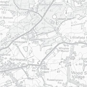
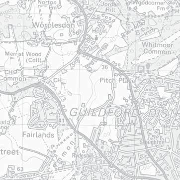
10 the Council s chosen spatial strategy, confirmed growth requirements and how the Council interprets the requirement to meet their objectively assessed housing needs. For this reason, Potential Development Areas have been identified, and retained, within some mid and higher sensitivity parcels. This does not imply that all such areas should be allocated for development within the Council s subsequent Local Plan Document, but identifies those areas that might be appropriate if there is a need to introduce development to those more sensitive parts of the Green Belt in order to meet the Council s growth requirements. 4.5 In assessing additional parcels around the main urban edge it has become apparent that the vast majority that were not assessed against sustainability and environmental capacity previously, are unable to accommodate development due to inadequate environmental capacity. In particular, the AONB to the south of Guildford, floodplains to the north and south, and notable areas of common land to the north-west of Guildford and north-east of Ash, mean that the ability to introduce any significant scale of development to many of the newly assessed parcels does not exist. 4.6 New PDAs were however identified at the following parcels; Land Parcel J1, Land at Liddington Hall Farm 4.7 The parcel adjoins the north-west edge of Guildford. It includes two roads supporting residential development towards its centre, and is partly contained by residential development on Sime Close, Findlay Drive and Gravetts Lane to the north, the latter of which also includes some commercial development. The parcel was highlighted as being potentially sensitive in terms of coalescence with Fairlands to the west. However, a strong area of woodland would be maintained between any development within the western part of the parcel and the eastern edge of Fairlands, meaning the visual connectivity between the two settlements could be limited appropriately. 4.8 Any proposed development would need to take account of the relationship with the common land at the southern corner of the parcel, and the impact upon the SNCI within it. The Green Belt boundary could be re-aligned to follow the line of Gravetts Lane to the north-west and Aldershot Road to the south-west, before entering the parcel to follow the line of the common land. 4.9 The PDA covers an area of approximately 28 ha, and could accommodate in the region of 625 dwellings. The PDA scored 8.57 against the sustainability April 2014 BNL.0287 Page 7
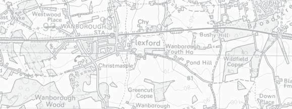
11 credentials and would therefore be ranked in the middle of those main urban edge parcels identified for PDAs, as indicated at Appendix 6. Land Parcel K3, Land south of Poyle Road, Tongham 4.10 The parcel adjoins the southern edge of Tongham, stretching from Poyle Road at its northern boundary to the A31 to the south, which follows the Hog s Back. Significantly, the parcel does not lie within the Green Belt at present, and is instead designated as lying within Countryside Beyond the Green Belt, in the Local Plan Due to the considerable area within the southern half of the parcel that is designated as AONB, a PDA across the entirety of the parcel would be inappropriate and an area has instead been identified to the north of the parcel. The PDA relates to Poyle Road, and incorporates land either side of the recreation ground and a woodland block. Development proposals will need to give consideration to any impact upon nearby areas of ancient woodland, the setting of nearby listed buildings, the SNCI to the east, and the potential for enhancement of planting along the southern edge to assist with an appropriate relationship with the AONB further to the south on the Hog s Back The PDA covers an area of approximately 24 ha, and could accommodate in the region of 572 dwellings. The PDA scored against the sustainability credentials and would therefore be ranked at the higher end of those main urban edge parcels identified for PDAs, as indicated at Appendix 6. April 2014 BNL.0287 Page 8
12 Appendix 1 Green Belt Purposes Schedule April 2014 BNL.0287
13 Appendix 2 Green Belt Purposes Sensitivity Plan April 2014 BNL.0287
14 Appendix 3 Environmental Capacity Analysis April 2014 BNL.0287
15 Appendix 4 Environmental Designation and Local Plan Policy Mapping April 2014 BNL.0287
16 Appendix 5 Sustainability Walking Distances for Land Parcels J1 and K3 April 2014 BNL.0287
17 Appendix 6 Sustainability Assessment Scoring April 2014 BNL.0287
18 Appendix 7 Residential Capacity Calculations April 2014 BNL.0287
19 Appendix 8 Updated Potential Development Areas (PDAs) surrounding Urban Areas April 2014 BNL.0287
GUILDFORD BOROUGH GREEN BELT AND COUNTRYSIDE STUDY
 GUILDFORD BOROUGH GREEN BELT AND COUNTRYSIDE STUDY Volume V On behalf of Guildford Borough Council PPG Ref : BNL.0287 April 2014 COPYRIGHT The conents of this document must not be copied or reproduced
Oxford Green Belt Study. Summary of Final Report Prepared by LUC October 2015
 Oxford Green Belt Study Summary of Final Report Prepared by LUC October 2015 Project Title: Oxford Green Belt Study Client: Oxfordshire County Council Version Date Version Details Prepared by Checked by
LEEDS SITE ALLOCATIONS PLAN MATTER 3 GREEN BELT KCS DEVELOPMENT AUGUST 2017
 LEEDS SITE ALLOCATIONS PLAN MATTER 3 GREEN BELT KCS DEVELOPMENT AUGUST 2017 Smith Limited Suite 9C Joseph s Well Hanover Walk Leeds LS3 1AB T: 0113 2431919 F: 0113 2422198 E: planning@peacockandsmith.co.uk
Proposed Sheffield City Region Combined Green Belt Review A Common Approach August 2014
 Proposed Sheffield City Region Combined Green Belt Review A Common Approach August 2014 1.1 Purpose To achieve the principles of Duty to Cooperate, it is beneficial for all Local Authorities within the
Plumpton Neighbourhood Development Plan Revised Pre Submission Document - Regulation 14 Consultation
 REPRESENTATIONS... Plumpton Parish Council Plumpton Neighbourhood Development Plan Revised Pre Submission Document - Regulation 14 Consultation Representations submitted on behalf of: Cala Homes (South
Site Assessment Technical Document Appendix A: Glossary
 Central Bedfordshire Council www.centralbedfordshire.gov.uk Site Assessment Technical Document Appendix A: Glossary July 2017 1.1.11-1 - ii Appendix A: Glossary Term Agricultural Land Classification AONB
Cookham Parish Council s Response to The Draft Local Borough Plan
 Cookham Parish Council s Response to The Draft Local Borough Plan As Agreed at the Planning Committee Meeting on 10 th January 2017. Designation of Poundfield as a Local Green Space The Parish Council
UTT/17/2075/FUL - (BERDEN) (Referred to Committee by Councillor Janice Loughlin. Reason: In the Public Interest)
 (Referred to Committee by Councillor Janice Loughlin. Reason: In the Public Interest)") UTT/17/2075/FUL - (BERDEN) (Referred to Committee by Councillor Janice Loughlin. Reason: In the Public Interest) PROPOSAL: LOCATION: APPLICANT: Amendments to the design of a scheme for a 49.99MW battery
UTT/17/2075/FUL - (BERDEN) (Referred to Committee by Councillor Janice Loughlin. Reason: In the Public Interest) PROPOSAL: LOCATION: APPLICANT: Amendments to the design of a scheme for a 49.99MW battery
Babergh and Mid Suffolk Joint Draft Local Plan Consultation, August 2017, Public Consultation
 Babergh and Mid Suffolk Joint Draft Local Plan Consultation, August 2017, Public Consultation Having reviewed the documents, the Society has made the following response: Housing Delivery Q 7. Do you agree
Settlement Boundaries Methodology North Northumberland Coast Neighbourhood Plan (August 2016)
") Introduction This background paper sets out a methodology for the definition of settlement boundaries in the North Northumberland Coast Neighbourhood Plan. The neighbourhood plan is planning positively
Introduction This background paper sets out a methodology for the definition of settlement boundaries in the North Northumberland Coast Neighbourhood Plan. The neighbourhood plan is planning positively
Draft Hailey Neighbourhood Plan
 Persimmon Homes (Wessex) Draft Hailey Neighbourhood Plan Representations to West Oxfordshire District Council s Regulation 16 Consultation December 2018 2 Copyright 2018 Persimmon Homes Ltd. All rights
Suffolk Coastal Local Plan Review Issues and Options, August 2017, Public Consultation
 Suffolk Coastal Local Plan Review Issues and Options, August 2017, Public Consultation Having reviewed the issues and options documents, the Society has made the following response: Part 1 - Strategic
viii Figure ES1: Recommended changes to Green Belt boundaries in Waverley
 viii Figure ES1: Recommended changes to Green Belt boundaries in Waverley 50 3.4 Elstead (segments W5, W11, W18, W19) 3.4.1 Area of search 51 3.4.2 Assessment against Green Belt criteria Segment W5: land
Development in the setting of the Cotswolds AONB
 COTSWOLDS CONSERVATION BOARD POSITION STATEMENT Development in the setting of the Cotswolds AONB.1. Introduction Areas of Outstanding Natural Beauty (AONBs) are designated by the Government for the purpose
DUNSFOLD NEIGHBOURHOOD PLAN Site Selection Policies
 DUNSFOLD NEIGHBOURHOOD PLAN Site Selection Policies The criteria for assessing sites for future housing and business development in Dunsfold are set out below. (Development criteria, covering what it is
GREEN BELT ASSESSMENT OF HOLLANDS FARM, BOURNE END AND SURROUNDING AREA
 27 November 2017 SHF/AC P17-1325 KBEG OF HOLLANDS FARM, BOURNE END AND SURROUNDING AREA PREPARED ON BEHALF OF KEEP BOURNE END GREEN (KBEG) Prepared by: SARAH HAMILTON FOYN BSc (Hons) Dip TP MRTPI ANDREW
Toddington Central Bedfordshire Stage 3 Green Belt Study December 2017
 Toddington Central Bedfordshire Stage 3 Green Belt Study December 2017 Site: ALP086 - Middle Lakes, Toddington Site size (ha): 2.83 Site: ALP086 - Middle Lakes, Toddington Site size (ha): 2.83 Site description
LONGDEN VILLAGE DEVELOPMENT STATEMENT
 LONGDEN VILLAGE DEVELOPMENT STATEMENT 2017-2027 1 Longden Development Statement 2017-2027 15/01/18 1. Background 1.1 Longden Village Longden village is a very rural and traditional community first mentioned
ROCHFORD LOCAL DEVELOPMENT FRAMEWORK: Sustainability Appraisal/ Strategic Environmental Assessment. Rochford Core Strategy Preferred Options Document
 ROCHFORD LOCAL DEVELOPMENT FRAMEWORK: Sustainability Appraisal/ Strategic Environmental Assessment Non Technical Summary Rochford Core Strategy Preferred Options Document October 2008 SUSTAINABILITY APPRAISAL
Great Easton Sustainable Housing Development Sites - Site Seven, Broadgate extension site SHLAA Ref HSG/03)
") Great Easton Sustainable Housing Development Sites - Site Seven, Broadgate extension site SHLAA Ref HSG/03) 1. Introduction The Great Easton Neighbourhood Plan Group are preparing a Neighbourhood Plan
Great Easton Sustainable Housing Development Sites - Site Seven, Broadgate extension site SHLAA Ref HSG/03) 1. Introduction The Great Easton Neighbourhood Plan Group are preparing a Neighbourhood Plan
Replacement Golf Course Facilities and Residential Development, Churston. Environmental Statement Non-Technical Summary
 Replacement Golf Course Facilities and Residential Development, Churston Environmental Statement Non-Technical Summary July 2011 Reproduced from the Ordnance Survey s map with the permission of the Controller
Joint Core Strategy Rushden Sustainable Urban Extension
 Date Page 1 of 18 Report Originator Title Planning Manager Joint Core Strategy Rushden Sustainable Urban Extension 1. PURPOSE OF REPORT 1.1 To consider representations received on the emerging Joint Core
EAST OF ENGLAND OFFICE
 Mr Philip Isbell Direct Dial: 01223 582751 Mid Suffolk District Council 131 high Street Our ref: P00524468 Needham Market Ipswich Suffolk IP6 8DL 18 January 2017 Dear Mr Isbell T&CP (Development Management
Guildford Borough. Flood Risk Sequential and Exception Test. May 2016
 Guildford Borough Flood Risk Sequential and Exception Test May 2016 Contents Relevant documents 3 Introduction 3 Background 3 What is the Sequential Test? 4 Stages of the Sequential Test 6 How should the
The analysis of key visual characteristics and attributes that contribute to variations in the
 15.0 CHIGWELL/CHIGWELL ROW 15.1 Overview 15.1.1 Chigwell and Chigwell Row settlements are situated in the south of Epping Forest District, to the south of Abridge and southwest of Stapleford Abbotts. Both
SOUTH EAST LINCOLNSHIRE LOCAL PLAN: HOUSING PAPER DONINGTON (JUNE 2016)
") SOUTH EAST LINCOLNSHIRE LOCAL PLAN: HOUSING PAPER DONINGTON (JUNE 2016) 1 DONINGTON S PLACE IN THE SPATIAL STRATEGY 1.1 Policy 2 of the South East Lincolnshire Local Plan 2011-2036 Draft for Public Consultation
SOUTH EAST LINCOLNSHIRE LOCAL PLAN: HOUSING PAPER DONINGTON (JUNE 2016) 1 DONINGTON S PLACE IN THE SPATIAL STRATEGY 1.1 Policy 2 of the South East Lincolnshire Local Plan 2011-2036 Draft for Public Consultation
About 10% of the Borough's population lives in the seven rural parishes. Population figures from the 1991 census are given below:-
 8. THE DISTRICT VILLAGES 8.1 Population About 10% of the Borough's population lives in the seven rural parishes. Population figures from the 1991 census are given below:- Village No. of Persons Cottingham
Droitwich Spa 6. Reasoned Justification
 87 Droitwich Spa 6 Reasoned Justification 6.1 Droitwich Spa is identified in the settlement hierarchy (Policy SWDP1) as a main town being the largest settlement in Wychavon District with an estimated population
Effingham Neighbourhood Plan 1. Basic Conditions Statement
 Effingham Neighbourhood Plan 1 Basic Conditions Statement Effingham Neighbourhood Plan 2016: Basic Conditions Statement 2 Contents This statement has been prepared by Effingham Parish Council to accompany
Neighbourhood Plan Representation
 Date: 10 th November 2017 Neighbourhood Plan Representation Land to the east of Callow Hill Road, Alvechurch Introduction This representation has been prepared by RPS Planning and Development on behalf
Historic England Advice Report 26 August 2016
 Case Name: Kingsland Castle Case Number: 1435892 Background Historic England has been asked to review the scheduling for Kingsland Castle. The land on which the monument lies is understood to be for sale.
Totternhoe Central Bedfordshire Stage 3 Green Belt Study December 2017
 Totternhoe Central Bedfordshire Stage 3 Green Belt Study December 2017 Site description The site is comprised of a single arable field on the southern side of the washed over settlement of Totternhoe.
DONCASTER METROPOLITAN BOROUGH COUNCIL. PLANNING COMMITTEE - 15th October Expiry Date:
 DONCASTER METROPOLITAN BOROUGH COUNCIL PLANNING COMMITTEE - 15th October 2013 Application 3 Application Number: 13/01158/FUL Application Expiry Date: 31st July 2013 Application Type: Full Application Proposal
Derry City and Strabane District Council Planning Committee Report
 Derry City and Strabane District Council Planning Committee Report COMMITTEE DATE: 23 rd March 2016 APPLICATION No: APPLICATION TYPE: PROPOSAL: LOCATION: APPLICANT: LA11/2015/0395/F Residential Development
Test Valley Borough Council Southern Area Planning Committee 8 January 2019
 ITEM 11 APPLICATION NO. 18/02218/FULLS APPLICATION TYPE FULL APPLICATION - SOUTH REGISTERED 23.08.2018 APPLICANT Rugby Football Union SITE The Trojans Club, Stoneham Lane, Eastleigh, SO50 9HT, CHILWORTH
Land to the North of Main Road, Wybunbury
 Land to the North of Main Road, Wybunbury Environmental Statement Non-Technical Summary November 2014 Land to the North of Main Road, Wybunbury Environmental Statement Non-Technical Summary Prepared on
Land East of Cromwell Lane
 Land East of Cromwell Lane VISION DOCUMENT AUGUST 2016 The proposals for Land East of Cromwell Lane will be defined by existing landscape features, ensuring that the development offers a quality place
DEVELOPMENT MANAGEMENT REPORT
 ITEM A08-1 DEVELOPMENT MANAGEMENT REPORT TO: BY: DATE: DEVELOPMENT: SITE: WARD: APPLICATION: APPLICANT: Development Management Committee Development Manager Proposed live/work unit in connection with existing
PLANNING COMMITTEE REPORT
 PLANNING COMMITTEE REPORT TO: BY: Planning Committee South Head of Development DATE: 19 December 2017 DEVELOPMENT: SITE: WARD: APPLICATION: APPLICANT: Conversion of existing water storage reservoir to
Strategic Green Belt Review
 Gre Strategic Green Belt Review Final Report South West Regional Assembly February 2006 Strategic Green Belt Review Final Report South West Regional Assembly February 2006 Strategic Green Belt Review Final
Perth and Kinross Council Development Management Committee 20 February 2013 Report of Handling by Development Quality Manager
 Perth and Kinross Council Development Management Committee 20 February 2013 Report of Handling by Development Quality Manager 4(4)(iii) 13/81 Erection of sports hall, associated changing facilities, offices
North Hertfordshire Green Belt Review
 North Hertfordshire Green Belt Review July 2016 North Hertfordshire Local Plan 2011-2031 Evidence Base Report 2 Contents 1. Background and Approach to the Review. PART ONE: ASSESSMENT OF THE CURRENT GREEN
Examination of South Cambridgeshire Local Plan
 Matter SC6A - Policy SS/5 Waterbeach New Town Historic England( formerly English Heritage) 874 Rep Nos 59748, 60250, 60253 Examination of South Cambridgeshire Local Plan Historic England, Hearing Statement
St Michaels C of E Junior & Infant School, Nantmel Grove, Bartley Green, Birmingham, B32 3JS
 Committee Date: 06/03/2014 Application Number: 2013/08595/PA Accepted: 19/11/2013 Application Type: Full Planning Target Date: 14/01/2014 Ward: Bartley Green St Michaels C of E Junior & Infant School,
SOUTH CAMBRIDGESHIRE DISTRICT COUNCIL. Director of Development Services
 SOUTH CAMBRIDGESHIRE DISTRICT COUNCIL REPORT TO: Development and Conservation Control Committee 1 st June 2005 AUTHOR/S: Director of Development Services S/0743/05/F - Great Shelford Extension and Conversion
Pegasus Group PEGASUS GROUP PLANNING OUR SERVICES
 Pegasus Group PEGASUS GROUP PLANNING OUR SERVICES PLANNING DESIGN ENVIRONMENT ECONOMICS ABOUT US Pegasus Group was established in 2003 and has grown to become a leading independent national planning consultancy,
Planning Position Statement Dunsfold Park. Dunsfold Airport Ltd
 Planning Position Statement Dunsfold Park Dunsfold Airport Ltd Quality Assurance Site name: Client name: Dunsfold Park Dunsfold Airport Ltd Type of report: Planning Position Statement Prepared by: Tim
GUILDFORD BOROUGH GREEN BELT & COUNTRYSIDE STUDY
 May 2014 BNL.0287 GUILDFORD BOROUGH GREEN BELT & COUNTRYSIDE STUDY Volume VI Insetting of Gypsy and Traveller Sites and defining Green Belt Boundaries within Guildford Borough Reference: BNL.0287 Date:
South East Bedfordshire WARD COUNCILLORS Cllr Ruth Gammons & Cllr Richard Stay
 Item No. 10 SCHEDULE A APPLICATION NUMBER CB/10/01265/OUT LOCATION Wyevale Garden Centres Plc, Dunstable Road, Caddington, Luton, LU1 4AN PROPOSAL Erection of new garden centre and office accommodation.
And now... The KEY Arguments in. Greater Detail
 And now... The KEY Arguments in Greater Detail 'Exceptional Circumstances' Are Needed to Change the Green Belt EBC justification to build on Green Belt is based on: SHMA guestimate of housing needs for
Statement of Community Involvement LAND OFF SOUTHDOWN ROAD HORNDEAN, HAMPSHIRE
 LAND OFF SOUTHDOWN ROAD HORNDEAN, HAMPSHIRE CONTENTS Page 1. Introduction 3 2. Pre-application Discussions 4 3. The Consultation Process 5 4. Consultation Feedback 7 5. Responses to Consultation Feedback
SOUTH CAMBRIDGESHIRE DISTRICT COUNCIL. Planning and New Communities Director
 SOUTH CAMBRIDGESHIRE DISTRICT COUNCIL REPORT TO: Planning Committee 9 January 2013 AUTHOR/S: Planning and New Communities Director S/2270/12/FL FEN DRAYTON 850m long flood defence embankment ranging in
Neighbourhood Planning Guidance Local Green Spaces
 Neighbourhood Planning Guidance Local Green Spaces Introduction This guidance note has been produced for communities preparing neighbourhood plans in North Dorset to help them to identify, assess and designate
Schedule of Planning Applications Committee Date: 23 May Reference: 06/17/0726/F Parish: Hemsby Officer: Mr J Beck Expiry Date:
 Schedule of Planning Applications Committee Date: 23 May 2018 Reference: 06/17/0726/F Parish: Hemsby Officer: Mr J Beck Expiry Date: 22-05-2018 Applicant: Proposal: Site: Mr Gillett Change of use to the
Development of land adjacent to Braggs Farm Lane and Rumbush Lane, Dickens Heath. Welcome. Today s exhibition. The proposal site
 Welcome Welcome to this event to discuss the development of land adjacent to Braggs Farm Lane. is currently in the preliminary stages of designing proposals to sensitively develop this site with high-quality
There are two assessment methods used. The first is according to the criteria set out in the Neighbourhood Plan which are set out below.
 Background Paper 4 Site Assessments Context This background paper has been compiled to support the Gotham Neighbourhood Plan and is intended to document the viability of sites around Gotham with respect
REFERENCE: B/03745/12 Received: 02 October 2012 Accepted: 05 October 2012 WARD(S): Totteridge Expiry: 30 November 2012.
: Totteridge Expiry: 30 November 2012.") LOCATION: 15A Pyecombe Corner, London, N12 7AJ REFERENCE: B/03745/12 Received: 02 October 2012 Accepted: 05 October 2012 WARD(S): Totteridge Expiry: 30 November 2012 Final Revisions: APPLICANT: PROPOSAL:
LOCATION: 15A Pyecombe Corner, London, N12 7AJ REFERENCE: B/03745/12 Received: 02 October 2012 Accepted: 05 October 2012 WARD(S): Totteridge Expiry: 30 November 2012 Final Revisions: APPLICANT: PROPOSAL:
Urban Growth Boundaries
 Urban Growth Boundaries Discussion Document July 2008 Contents page Introduction... 3 What are urban growth boundaries?... 3 The need to manage growth... 3 Purpose of urban growth boundaries... 4 How will
Public Consultation. Land at Monks Farm, North Grove. Welcome
 Welcome Welcome to our public exhibition for development on Land at Monks Farm, orth Grove. Gallagher Estates and Gleeson Strategic Land are preparing an outline planning application for new homes, open
Councillor John Kingsbury Woking Borough Council Civic Offices Gloucester Square Woking Surrey GU21 6YL
 Councillor John Kingsbury Woking Borough Council Civic Offices Gloucester Square Woking Surrey GU21 6YL Dear Cllr Kingsbury Introduction LDA Design has been appointed by the Pyrford Neighbourhood Forum
Development in the Green Belt
 Supplementary Planning Document: Development in the Green Belt Consultation Draft February 2013 Local Development Framework How to comment This document was published on 21st March 2013 and comments should
Blandford Forum Town Council, Blandford St Mary Parish Council and Bryanston Parish Council
 Blandford Forum Town Council, Blandford St Mary Parish Council and Bryanston Parish Council Blandford + Neighbourhood Plan 2 Pre-Submission Plan Consultation (November 2018) Representations submitted on
INTRODUCTION CURRENT APPLICATION
 05/01805/FUL & 05/01807/LBC ERECTION OF A SINGLE DWELLING HOUSE WITH ANCILLARY ACCOMMODATION AT Flamingo Zoological Gardens, Olney Road, Weston Underwood FOR Mr A J Crowther (as amended by letter dated
UTT/16/1466/DFO GREAT DUNMOW MAJOR
 UTT/16/1466/DFO GREAT DUNMOW MAJOR PROPOSAL: LOCATION: APPLICANT: AGENT: Reserved matters approval for the accesses to the site and principal roads within the site including spine road following outline
LAND EAST OF HORNDEAN. 1. Welcome. Morrisons supermarket. Keydell Nurseries A3(M)
") 1. Welcome Bloor Homes welcomes you to today s Public Exhibition relating to development proposals for Land to the East of Horndean. Idsworth Close Rowlands Castle Road Roa d Dell Piece East J2 Pyle Farm
1. Welcome Bloor Homes welcomes you to today s Public Exhibition relating to development proposals for Land to the East of Horndean. Idsworth Close Rowlands Castle Road Roa d Dell Piece East J2 Pyle Farm
SITE ASSESSMENTS. September 2018 SOUTHWATER PARISH COUNCIL BEESON HOUSE, 26 LINTOT SQUARE, SOUTHWATER, RH13 9LA
 September 2018 SITE ASSESSMENTS PREPARED TO ASSIST THE PREPERATION OF THE SOUTHWATER NEIGHBOURHOOD PLAN SOUTHWATER PARISH COUNCIL BEESON HOUSE, 26 LINTOT SQUARE, SOUTHWATER, RH13 9LA INTRODUCTION TABLE
Sustainability Statement. Whitby Business Park Area Action Plan
 Sustainability Statement Whitby Business Park Area Action Plan November 2014 Contents Page 1. Introduction 1 2. Scoping 3 3. Sustainability Appraisal of Options 6 4. Assessment of Draft Area Action Plan
Longmore House Salisbury Place Edinburgh EH9 1SH. 18 January 2008
 We safeguard the nation s historic environment and promote its understanding and enjoyment Martin Dean Access and Countryside Projects Officer Development and Environmental Services Clackmannanshire Council
Neighbourhood Planning Local Green Spaces
 Neighbourhood Planning Local Green Spaces Introduction... 2 1. Why green space is important... 4 2. Neighbourhood plans and green space... 6 3. Evidence... 8 Statutory designations... 9 Green space audit...
A Quick Guide to The Green Belt
 Page 0 of 9 Working together to build the homes we need A Quick Guide to The Green Belt October 2017 Page 1 of 9 What is the Green Belt? The modern Green Belt dates back to the Town and Country Planning
2014/0590 Reg Date 26/06/2014 Chobham
 2014/0590 Reg Date 26/06/2014 Chobham LOCATION: PROPOSAL: TYPE: APPLICANT: OFFICER: ASCOT PARK POLO CLUB, WESTCROFT PARK FARM, WINDLESHAM ROAD, CHOBHAM, WOKING, GU24 8SN Erection of a two storey detached
Planning and Regulatory Committee 20 May Applicant Local Councillor Purpose of Report
 Planning and Regulatory Committee 20 May 2014 7. APPLICATION FOR PLANNING PERMISSION FOR THE CARRYING-OUT OF DEVELOPMENT PURSUANT TO PLANNING PERMISSION REFERENCE NUMBER 603451 DATED 28 FEBRUARY 2007 WITHOUT
Designations protecting the historic designed landscape
 Historic Landscape Project Designations protecting the historic designed landscape A. Key national designations affecting the historic environment: 1. Listed buildings 2. Scheduled Monuments (generally
Perth and Kinross Council Development Management Committee 24 April 2013 Report of Handling by Development Quality Manager
 Perth and Kinross Council Development Management Committee 24 April 2013 Report of Handling by Development Quality Manager Alterations,Carpenter House, Carpenter Street, Perth, PH1 5GB Ref. No: 13/00303/FLL
Kibworth Harcourt. Introduction. Introduction
 Introduction Introduction Welcome to this public exhibition on the proposals for the delivery of new homes on land at The Kibworths. The purpose of today s exhibition is to give you the opportunity to
Alder View. Introduction. Alder View. Harwell. The Vision. The Team. Taylor Wimpey
 Introduction Welcome to the public exhibition for, a development by Taylor Wimpey on the land south of Grove Road,. This exhibition will provide an overview of the development proposals for the site and
an Inspector appointed by the Secretary of State for Communities and Local Government
 Appeal Decision Site visit made on 6 November 2017 by Rachel Walmsley BSc MSc MA MRTPI an Inspector appointed by the Secretary of State for Communities and Local Government Decision date: 19 th January
STATEMENT OF OBJECTION TO THE PROPOSED DEVELOPMENT OF LAND AT CHURCH CLIFF DRIVE FILEY
 STATEMENT OF OBJECTION TO THE PROPOSED DEVELOPMENT OF LAND AT CHURCH CLIFF DRIVE FILEY You will be aware that Scarborough borough council have adopted a new local plan that includes land at Church Cliff
The targets do not adhere to the government projections or methodology, being aspirational rather than achievable.
 Question 1: Preferred Growth Option (see pages 7-9 of the consultation document) Do you agree with the preferred growth option for the Joint Local Plan? The targets do not adhere to the government projections
Variation No 1: Dundalk & Environs Development Plan Core Strategy
 Variation No 1: Dundalk & Environs Development Plan 2009-2015 Core Strategy Adopted on 29 th August 2011 CONTENTS Page Section 1 1.0 Synopsis 1 1.1 Background Document 1 1.2 Variation of Dundalk and Environs
Tandridge Local Plan Assessing the Ecological Suitability of 183 sites considered for development Tandridge District Council, Surrey
 Tandridge Local Plan Assessing the Ecological Suitability of 183 sites considered for development Tandridge District Council, Surrey PLANNING I DESIGN I ENVIRONMENT 1.0 INTRODUCTION TEP conducted Site
Everton s Neighbourhood Plan. Site Allocation - Assessment Criteria
 Everton s Neighbourhood Plan Site llocation - ssessment Criteria Introduction 1.1 This report assesses all the sites identified through the emerging Neighbourhood Plan for Everton and their potential for
WELCOME. Land west of Great Canfield Road, Takeley. Welcome. Have your say. Pegasus Urban Design
 01 WELCOME Welcome Gladman Developments Ltd have successfully invested in communities throughout the UK over the past 20 years, developing high quality and sustainable residential, commercial and industrial
Representation to East Lothian Council Local Development Plan, Main Issues Report
 Representation to East Lothian Council Local Development Plan, Main Issues Report CALA Management Ltd - In respect of land at Pinkie Mains Farm, Inveresk Question 11: Musselburgh Cluster The Site The site
Evesham 7. Reasoned Justification
 95 Reasoned Justification 7.1 Evesham is situated within the Vale of Evesham and has an estimated population of 22,800 (2009 Mid-Term Population Estimates). As a main town it provides a wide range of services
Ward: Southbourne. White Croft 14 Breach Avenue Southbourne West Sussex PO10 8NB
 Parish: Southbourne Ward: Southbourne Proposal Site SB/15/01827/FUL Erection of a detached chalet bungalow. White Croft 14 Breach Avenue Southbourne West Sussex PO10 8NB Map Ref (E) 477023 (N) 106593 Applicant
46 Burley Street, Leeds, LS3 1LB Retail Statement
 , LS3 1LB Retail Statement , LS3 1LB Retail Statement October 2014 Indigo Planning Indigo Planning Limited Toronto Square Leeds LS1 2HJ Tel: 0113 380 0270 Fax: 0113 380 0271 info@indigoplanning.com indigoplanning.com
REFERENCE: B/00601/12 Received: 11 February 2012 Accepted: 21 February 2012 WARD(S): High Barnet Expiry: 17 April 2012
: High Barnet Expiry: 17 April 2012") LOCATION: 37 Kings Road, Barnet, Herts, EN5 4EG REFERENCE: B/00601/12 Received: 11 February 2012 Accepted: 21 February 2012 WARD(S): High Barnet Expiry: 17 April 2012 Final Revisions: APPLICANT: PROPOSAL:
LOCATION: 37 Kings Road, Barnet, Herts, EN5 4EG REFERENCE: B/00601/12 Received: 11 February 2012 Accepted: 21 February 2012 WARD(S): High Barnet Expiry: 17 April 2012 Final Revisions: APPLICANT: PROPOSAL:
Peter Brett Associates LLP (PBA) act on behalf of db symmetry ltd in respect of the proposed symmetry park, Kettering development (the Site).
 act on behalf of db symmetry ltd in respect of the proposed symmetry park, Kettering development (the Site).") Our ref: 30062 2 nd August 2017 Kettering Borough Council Planning Department Municipal Offices Bowling Green Rd Kettering NN15 7QX 61 Oxford Street Manchester M1 6EQ T: +44 (0)161 245 8900 E: manchester@peterbrett.com
Our ref: 30062 2 nd August 2017 Kettering Borough Council Planning Department Municipal Offices Bowling Green Rd Kettering NN15 7QX 61 Oxford Street Manchester M1 6EQ T: +44 (0)161 245 8900 E: manchester@peterbrett.com
1. Nantwich - Planning for a Sustainable Future
 1. Nantwich - Planning for a Sustainable Future Cheshire East Council is charged with preparing its Development Plan to guide housing and other growth over the period to 2030. The Council intends to publish
Dormouse Method Statement
 , Northamptonshire A Report on behalf of April 2013 CONTENTS 1.0 Introduction 1.1 Purpose of this Method Statement 1.2 Site Background 1.3 Dormouse Ecology & Legal Protection 2.0 Methodology 2.1 Tool Box
PROPOSED CARE HOME & ASSISTED LIVING DEVELOPMENT (C2), PYRTON LANE, WATLINGTON
, PYRTON LANE, WATLINGTON") Welcome - Meet the Team ABOUT BEECHCROFT Beechcroft has over 30 years experience of assisted living and retirement development and is one of the few house builders that specialise in this type of accommodation.
Welcome - Meet the Team ABOUT BEECHCROFT Beechcroft has over 30 years experience of assisted living and retirement development and is one of the few house builders that specialise in this type of accommodation.
Ipswich Issues and Options for the Ipswich Local Plan Review, August 2017, Public Consultation
 Ipswich Issues and Options for the Ipswich Local Plan Review, August 2017, Public Consultation Having reviewed the issues and options documents, the Society has made the following response: Part 1 Strategic
SOUTH CAMBRIDGESHIRE DISTRICT COUNCIL. Planning and New Communities Director
 SOUTH CAMBRIDGESHIRE DISTRICT COUNCIL REPORT TO: Planning Committee 5 June 2013 AUTHOR/S: Planning and New Communities Director S/0747/13/FL HISTON Construction of Car Park at Histon Baptist Church, Station
PART 2 SOUTH DOWNS NATIONAL PARK AUTHORITY SECTION 1 SCHEDULE OF APPLICATION RECOMMENDATIONS
 42 PART 2 SOUTH DOWNS NATIONAL PARK AUTHORITY PLANNING COMMITTEE REPORT OF THE SERVICE MANAGER PLANNING DEVELOPMENT Applications to be determined by the council on behalf of the South Downs National Park
Services Department B September 10, 2007
 Report To: Development Services Committee Item: Date of Report: DS-07-246 September 5, 2007 From: Commissioner, Development File: Date of Meeting: Services Department B7200-0001 September 10, 2007 Subject:
Reserved Matters application for a site that straddles the boundary between CBC and BBC
 BBC APPLICATION 15/02682/MAR NUMBER CBC APPLICATION CB/15/04294/RM NUMBER LOCATION Wixams Land at former storage depot, Bedford Road, Wilstead Bedfordshire PROPOSAL Reserved Matters Application for Strategic
BEDFORD BOROUGH COUNCIL PLAN IMPLEMENTATION MONITORING REPORT
 BEDFORD BOROUGH COUNCIL PLAN IMPLEMENTATION MONITORING REPORT 2017-18 Summary 1 Progress on local development documents 1 Local development documents adopted in the monitoring period 1st April 2017 31st
By to: 30 March Thank you for the opportunity to respond to this important consultation.
 70 Cowcross Street London EC1M 6EJ Tel: 0207 253 0300 Fax: 0207 490 3001 office@cprelondon.org.uk www.cprelondon.org.uk Environment, Housing & Regeneration London Borough of Sutton 24 Denmark Road Carshalton
A GUIDE TO THE FEES FOR PLANNING APPLICATIONS IN ENGLAND
 A GUIDE TO THE FEES FOR PLANNING APPLICATIONS IN ENGLAND These fees apply from 17 January 2018 onwards. This document is based upon The Town and Country Planning (Fees for Applications, Deemed Applications,