4.0 Zones and Overlays
|
|
|
- Julian Nelson Alexander
- 5 years ago
- Views:
Transcription


1 4.0 Zones and Overlays The following section details the existing zones and overlays within the Mooroopna West Growth Corridor. Revision 1 7 July 2009 Page 27
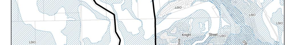
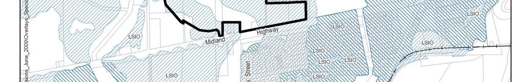
2 Due to the overall size (260 ha) and geographical location of the Mooroopna West growth corridor, a range of zones and overlays apply to the Mooroopna West OPD area. Refer to Figures 6, 7 and 8. The existing planning zone and overlay controls are summarised within Table 4. Table 4: Mooroopna West Growth Corridor Zones and Overlays Zones Overlays Residential 1 Land Subject to Inundation Farming Development Plan Schedule 1 Business 4 Rural Floodway Urban Floodway VicRoads PAO Revision 1 7 July 2009 Page 28


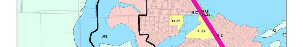
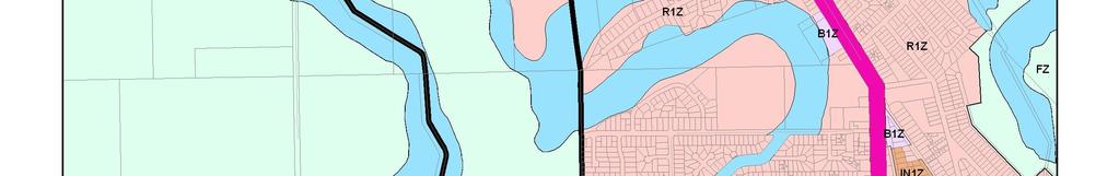
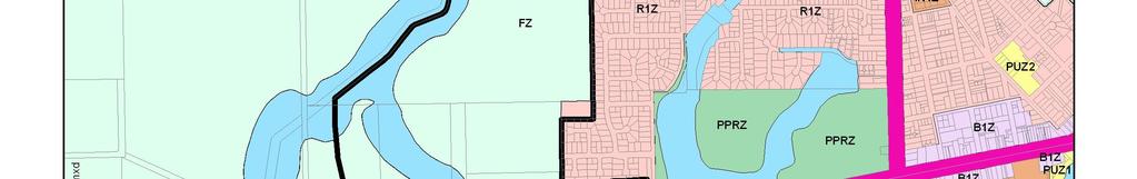
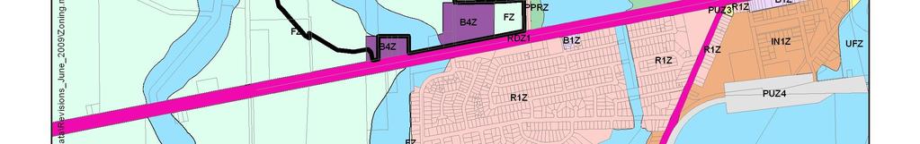
3 Figure 6: Zoning Plan Revision 1 7 July 2009 Page 29


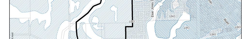
4 Figure 7: Flood Overlay Plan Revision 1 7 July 2009 Page 30


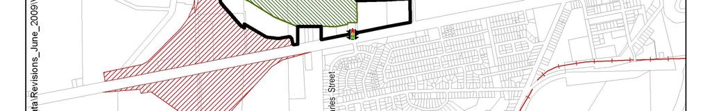
5 Figure 8: PAO & DPO1 Overlay Plan Revision 1 7 July 2009 Page 31


6 5.0 Identifying Developable Land This section provides a starting point in the overall strategic planning for the Mooroopna West Growth Corridor by way of the identification of developable land. It is noted within this section that a significant portion of the land can be classified as non developable due to major flooding constraints. In setting the future urban landscape for Mooroopna West, developable land has been identified within the following section via a set of precincts. Revision 1 7 July 2009 Page 32
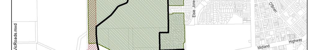
7 The precincts denoted within Figure 8, are land units that reflect localised topographical and flooding conditions. The precincts are not based on land ownership arrangements. A significant portion of the Mooroopna West Growth Corridor can be classified as non developable as it comprises land contained within an Urban Floodway Zone. The Urban Floodway Zone essentially traverses the corridor in a north-south alignment. A significant portion of the balance of the Mooroopna West Growth Corridor is affected by the Land Subject to Inundation Overlay and the Floodway Overlay but it remains developable subject to adequately addressing flood mitigation matters. Land situated in the south-western corner of the Mooroopna West Growth Corridor is identified by way of the Public Acquisition Overlay for future road purposes in association with the Goulburn Valley Highway Shepparton Bypass and on this basis, has not been included in future land development within the corridor.. The precinct areas are summarised within Table 5. Table 5: Mooroopna West Growth Corridor Development Precincts Precinct Gross Area (Hectares) A B C D Revision 1 7 July 2009 Page 33
8 Figure 9: Precincts Revision 1 7 July 2009 Page 34


9 6.0 Development Opportunities and Constraints The prevailing development opportunities and constraints within the Mooroopna West Growth Corridor have been identified within the following section to provide an existing conditions snapshot or a base line context for future land use and development. The form, extent and locations of land use and development within the Mooroopna West Growth Corridor will be inextricably linked to the pre-existing opportunities and constraints. At a micro level, these issues will need upfront consideration by proponents in preparing and lodging permit planning applications. Revision 1 7 July 2009 Page 35
10 6.1 Development Opportunities The Mooroopna West Growth Corridor is characterised by the following land use and development opportunities. These opportunities will influence, to varying degrees, the form and extent of future development through the growth corridor. Where appropriate, a subdivision or development plan within the Mooroopna West Structure Plan should address these considerations Existing Subdivisions A key opportunity for new residential development within the Mooroopna West Growth Corridor is the capacity to integrate in a permeable manner with existing residential areas at the periphery Mooroopna. The existing residential areas are located to the north of the Midland Highway and to the west of the Echuca Mooroopna Road. Existing roads such as Knight Street and Mac Isaac Road, as the main collector roads, can be used to service the Mooroopna West Growth Corridor. The alignment and design of these roads ensure that they have the capacity to link in with the proposed North-South Road within the Mooroopna West Growth Corridor. Existing public open space areas have generally been configured along the floodway and Ardmona Drain alignments. This presents an opportunity to provide active and passive open space linkages with new subdivisions within the Mooroopna West Growth Corridor Land Supply Limitations Land available for development within Mooroopna is limited, predominantly by natural constraints such as flood prone areas but also by man-made physical boundaries such as the future Goulburn Valley Highway - Shepparton Bypass alignment. When combined, these create a limitation on the supply of residential allotments. Additional residential lots and housing must be brought on line to address the demand side of the equation. Individual land owner tenure expectations need to be managed in a coordinated manner to avoid out of sequence development Proximity to the Commercial Centres The proximity of the Mooroopna West Growth Corridor to the main commercial centres of Shepparton and Mooroopna represents an opportunity for future residential development. Shepparton is the key commercial and business centre for the local region. The Central Business District of Shepparton provides a range of higher and lower order goods and services for not only the urban area but also the surrounding rural and township areas. The main shopping centre for Mooroopna is conveniently located along McLennan Street. It provides the township and immediately surrounding area with a range of goods and services. A number of nonresidential uses such as a petrol station, a supermarket and a performing arts community centre are located along Echuca Mooroopna Road. New commercial development to service the Mooroopna West Growth Corridor should be established. An objective of the Council is to ensure that local, small scale convenience shopping centres are available for new residential areas. Retail facilities should be made accessible through walking and cycling networks, served by public transport, located on the North-South Road. Retail opportunities should be an appropriate size to accommodate uses that meet local community needs and oriented to support active street frontages, street -based community interaction and pedestrian safety. Investigation by ADR indicates that there is an opportunity to establish retail clusters within Precinct A and C to service the growth corridor and provide a mix of uses to meet the growth corridors needs. The cluster in Precinct A should be secondary to the cluster in Precinct C. The ADR Report is Appendix D to this report. Revision 1 7 July 2009 Page 36
11 6.1.4 Flora and Fauna The Mooroopna West Growth Corridor has a highly disturbed natural environment and as a consequence possesses minimal flora and fauna attributes. Extensive tree clearing and cattle grazing throughout the growth corridor has impacted on native vegetation coverage. A cluster of Grey Box situated along Excelsior Road comprises the only native vegetation of note. The cluster of Grey Box have been excluded from the developable area in order to protect its environmental values. Any development in the vicinity of the vegetation will need to be in accordance with DSE requirements. Opportunities exist to link open space areas within the Mooroopna West Growth Corridor with Gemmill Wildlife Reserve on the eastern side of Echuca Mooroopna Road. Given the overall degree of non developable land due to flooding; there is significant scope to introduce plants, shrubs and trees in these particular areas Public Open Space Provision The Mooroopna West Growth Corridor provides significant scope to accommodate a high quality, integrated public open space network. The public open space opportunity is primarily derived from the Ardmona (Community Drain) 7P running south north through the Mooroopna West Growth Corridor which although it is a key land development constraint, it provides scope to satisfy various open space planning objectives. The floodway area extending throughout the growth corridor has been designated for the provision of a linear open space network. The size and distribution of public open space relative to future urban development will support and encourage a variety and diversity of uses, particularly through the provision of a shared pathway network. Public open space provision within the Mooroopna West Growth Corridor will also accommodate drainage mitigation measures, water sensitive urban design and enhancement of the local landscape values through native vegetation planting. The linear network also provides opportunity to link to other active and passive open space areas including Gemmills Wildlife Reserve, Craigmuir Lake and John Gray Reserve as well as new dedicated open space areas (i.e. local parks and playgrounds) within the Mooroopna West Growth Corridor. Landscaping of POS is a requirement of the Development Plan Community Infrastructure Existing facilities that currently make up the community infrastructure servicing the Mooroopna population are either at capacity or very close to being fully utilized by the existing population base. The development of the Mooroopna Hub, which was a $2.5 million dollar redevelopment to co-locate and upgrade the community house, preschool, occasional childcare, maternal and child health, senior citizens facilities and an expanded community library, is an example of a response to the need to upgrade and extend existing facilities to meet current needs and expectations. The future population and household growth expected within the Mooroopna West Growth Corridor will bring with it a need to extend existing and create new community infrastructure to satisfy local needs and expectations for community services. Future subdivisions will need to ensure that accessibility and connectivity is provided to the new Mooroopna West community hub and local public transport services. The Demographic and Community Centre Analysis by Maunsell indicates that it is appropriate for there to be an additional hub within the Mooroopna West Growth Corridor. The Structure Plan sets aside an area of land for this future hub. In accordance with the Ministers Direction on Development Contribution Plans under Section 46M (1) of the Planning and Environment Act 1987, the DCP will only fund the part of the hub that relates to children s services. A copy of this report is given in Appendix E. Revision 1 7 July 2009 Page 37

12 6.1.7 New Mooroopna West Primary School The Department of Education and Training (DET) has indicated that the expected level of population growth within the Mooroopna West Growth Corridor will necessitate the provision of a new primary school given the limited number of places currently available at Mooroopna s two existing State primary schools. As a general rule, a primary school is required for every 3,000 dwellings and a high school for every 10,000 dwellings. To accommodate the establishment of a new primary school, a site should incorporate the following: A minimum site area of 3.5 hectares; Preferably 3 road frontages; Be integrated with the local neighbourhood centres and community facilities; Be located on walking and cycling networks; Adjoin public open space network and community sporting and other recreation facilities; Include the provision of indented, parallel parking, drop off zones, bus stops; Have a bus stop located along the school site boundary; Be located on land that is not affected by physical, environmental or other constraints; and For primary schools, be located on connector streets. The preferred location for the establishment of a new primary school within the Mooroopna West Growth Corridor is within Precinct A. This precinct, given its location and physical area, provides the best all-round scope to accommodate a new primary school in conjunction with a new local commercial hub (or local centre). 6.2 Development Constraints The Mooroopna West Growth Corridor is characterised by the following constraints and these issues all serve to impact on the future development and land supply at Mooroopna West. Identified constraints within the growth corridor such as drainage channels may also provide opportunities such as the provision of high quality public open space Flooding and Drainage Infrastructure The convergence of a number of river systems in the region of Mooroopna and Shepparton means that the Mooroopna West Growth Corridor is highly susceptible to flooding. Gemmill Swamp, Craigmuir Lake and the Goulburn River are the main waterways within and in close proximity to Mooroopna. The physical extent of flooding with the Mooroopna West Growth Corridor has implications for the type, form and location of drainage infrastructure that needs to be provided. In addition to riverine flooding, the flat topographical nature of the area generally makes it a difficult to dispose of local stormwater. Existing flood channels and storage areas need to be maintained with new urban development. Development must avoid areas of flooding depth in excess of 300mm above natural ground level. Figure 10: Gemmill Swamp Facing South East from Little Road Revision 1 7 July 2009 Page 38
13 Allied with the problem of riverine flooding and local stormwater is the need to protect and enhance Mooroopna s waterways. Stormwater development within the existing residential areas abutting the Mooroopna West Growth Corridor is directed to Gemmill Swamp via a series of pipe outlets. Nutrient levels need to be managed otherwise floral species in receiving areas such as Gemmill Swamp can be affected. Due to the flood prone nature of the land, riverine flood mitigation works, drainage infrastructure and stormwater management will present a significant cost impost on subdivision and development Other Existing Physical Infrastructure Services To accommodate the anticipated residential growth within the Mooroopna West Growth Corridor, augmentation of infrastructure may be necessary. The existing capacity of physical infrastructure servicing Mooroopna West and future growth issues for each servicing authority is summarised overleaf. Gas Origin Energy has indicated that a good supply gas is available to the Mooroopna West area. Existing reticulated gas infrastructure has sufficient capacity to be able to supply the 2500 new homes without any reinforcement to the reticulation system. Power The Mooroopna West Growth Corridor is in the area supplied by Mooroopna zone substation (MNA). The substation is located on the Echuca-Mooroopna Road, opposite Gange Street. The substation is supplied by two 66 kv lines, one directly from the terminal, and one via Shepparton zone substation (STN). Based on present load forecasts and planning policy, Powercor expects in 2013 there will be a need to carry out works to avoid unacceptable overloads and load at risk for supply to customers ex MNA. The station rating and both 66 kv line ratings will be an issue. The exact timing and scope of augmentation depends, in part, on load growth - where, when and how much. Load forecasts are reviewed biannually. Powercor has a number of existing assets in the Corridor. These assets include: At the northern end there is a 22 kv power line off Cornish Road, extending about 530 m into the property; and Along MacIsaac Road there is a 22 kv line on the south side, and a single pole line on the north side carrying both a 66 kv and 22 kv circuit. Lines along MacIsaac Road are in the road easement. Sewerage Goulburn Valley Water has advised that a recent assessment of the sewerage system has indicated that there is limited capacity available in the existing sewerage network. Therefore, extensive development to the West of Mooroopna is likely to require an independent sewerage network that will connect into the existing outfall rising main on Echuca Road which delivers waste to the Waste Management Facility situated to the north of Mooroopna. However, it is also likely that development of the scale being considered will also require augmentation of this outfall rising main as well. Water Goulburn Valley Water has prepared a Water Supply Master Plan. The 2002 Master Plan prepared for the Shepparton and Mooroopna water supply system had a 20-year outlook and assumed compounding growth of 1.0% per annum for Mooroopna. At this growth rate and from a base of approximately 3200 connected properties, an additional 720 properties could be connected to the Mooroopna water supply system by The Master Plan determined that development of this order could be accommodated with little modification to the existing water supply system. Revision 1 7 July 2009 Page 39
14 6.2.3 Goulburn Valley Highway - Shepparton Bypass The proposed Shepparton Bypass will involve approximately 30 kilometres of dual carriageway road. The Shepparton Bypass is to link the Goulburn Valley Highway at Arcadia in the south with the Congupna area to the north. It is anticipated that the Shepparton Bypass will reduce overall traffic volumes, particularly heavy vehicle traffic within the township areas of Mooroopna and Shepparton. The Goulburn Valley Highway runs from Seymour through to Tocumwal and forms part of the National Highway network. In relation to the Mooroopna West Growth Corridor, the alignment of the proposed Shepparton Bypass forms the westernmost boundary. The Shepparton Bypass alignment runs along the eastern side of Excelsior Avenue. In effect, it will provide a hard edge to residential development and the outward expansion of Mooroopna. The location of the proposed east bound off ramp onto the Midland Highway will significantly encroach upon developable land within the south-western section of the Mooroopna West Growth Corridor. The use of an overpass over the Midland Highway however effectively dictates the positioning of the off ramp. The Shepparton Bypass alignment not only represents a physical constraint on the western and southwestern edge of the Mooroopna West Growth Corridor, it also forms a major consideration in determining the layout and alignment of future internal road networks and intersectional arrangements Interface with Agricultural Land The interface between residential areas and surrounding agricultural landholdings at the township fringe has the potential for land use conflict. Physical buffers are generally used to mitigate negative externalities for new residential development. Issues such as dust, spray drift, noise and odour emissions have the potential to impact on sensitive receptors such as dwellings. Whilst the Mooroopna West Growth Corridor generally has hard edged boundaries such as the Midland Highway to the south and existing residential development, there is scope in the northern and western sections of the growth corridor for agricultural interface issues to arise. Revision 1 7 July 2009 Page 40
GREENBANK DEVELOPMENT MASTERPLAN
 DEVELOPMENT MASTERPLAN POTENTIAL TRAIN STATION COMMUNITY CENTRE Greenbank will be a connected masterplanned community providing easy access to local and surrounding amenity. Affordable quality homes, green
Draft Ada Street Cardiff Area Plan
 Draft Ada Street Cardiff Area Plan (Draft Amendment to Lake Macquarie Development Control Plan 2014) Exhibition: The draft Area Plan is on public exhibition from 29 February 2016 to 29 March 2016. Submissions:
Introduction How to read this document Land to which this Precinct Structure Plan applies Background information...
 Introduction... 4 How to read this document... 6 Land to which this Precinct Structure Plan applies... 6 Background information... 6 Shepparton North East Development Contributions Plan... 7... 8 OUTCOMES...
I615. Westgate Precinct
 I615. Westgate Precinct I615.1. Precinct Description The Westgate Precinct is located approximately 18km west of the Auckland city centre. There are seven Sub-precincts in the Westgate Precinct: Sub-precinct
I403 Beachlands 1 Precinct
 I403. Beachlands 1 I403.1. Precinct Description Beachlands is a rural and coastal village located on the eastern side of Auckland, adjoining the Tamaki Strait coastline. The original Beachlands village
Part 12 Precinct Area Plans - Wyee West
 TABLE OF CONTENTS 1 INTRODUCTION... 1 1.1 BACKGROUND... 1 1.2 EXTENT OF AREA PLAN... 1 1.3 EXISTING CHARACTER... 2 1.4 ENVIRONMENTAL ATTRIBUTES AND CONSTRAINTS... 2 1.5 DESIRED FUTURE CHARACTER... 3 1.6
Northern Territory Compact Urban Growth Policy
 Northern Territory Compact Urban Growth Policy A Reference Policy Document to clause 2.7 (Reference to Policy) of the NT Planning Scheme May 2015 Table of Contents 1 Policy Setting... 3 1.1 Context for
DRAFT TARNEIT WEST Outline Development Plan MAY 2007
 DRAFT TARNEIT WEST Outline Development Plan MAY 2007 Department of Strategy and Tourism Draft May 2007 Page 1 Table of Contents 1.0 Introduction...4 1.1 Overview...4 1.2 Land and Locality...4 1.3 Purpose
Barwon Heads Road. REGIONAL ACTIVE PUBLIC OPEN SPACE - Indicative Concept Only FIGURE C. Armstrong Creek East Precinct Structure Plan
 0 50 150 metres KEY Arterial Road (existing) Walking / Cycling link Residential Conventional Mixed Use Residential Medium Density Farming Drainage and Floodway Public Open Space Armstrong Creek Watercourse
I539. Smales 2 Precinct
 I539. Smales 2 Precinct I539.1. Precinct Description The Smales 2 Precinct applies to a 4.8 hectare block of land located on the southern side of Northcote Road and fronting Lake Pupuke, Takapuna. The
Shepparton North East Precinct Structure Plan. February 2018
 Shepparton North East Precinct Structure Plan February 2018 Contents 1.0 INTRODUCTION 5 1.1 How to read this document 7 1.2 Land to which this Precinct Structure Plan applies 7 1.3 Background information
Tāhuhu whakaruruhau ā-taone The sheltering ridge pole
 B2. Tāhuhu whakaruruhau ā-taone - Urban growth and form B2.1. Issues Tāhuhu whakaruruhau ā-taone The sheltering ridge pole Auckland s growing population increases demand for housing, employment, business,
Section 3b: Objectives and Policies Rural Environment Updated 19 November 2010
 Page 1 of Section 3b 3b RURAL ENVIRONMENT 3b.1 Introduction The Rural Environment comprises all the land outside of the Residential, Town Centre and Industrial Environments. Most land within the District
4 RESIDENTIAL ZONE. 4.1 Background
 4 RESIDENTIAL ZONE 4.1 Background The residential areas within the City are characterised by mainly lowrise dwellings sited on individual allotments. Past architectural styles, settlement patterns and
QUEENSTOWN LAKES DISTRICT COUNCIL SUBDIVISION DESIGN GUIDELINES
 Attachment C: Draft QLDC Subdivision Design Guidelines QUEENSTOWN LAKES DISTRICT COUNCIL DESIGN GUIDELINES A DESIGN GUIDE FOR AND DEVELOPMENT IN THE URBAN ZONES QUEENSTOWN OFFICE 10 Gorge Road Queenstown
I609. Penihana North Precinct
 I609. Penihana North Precinct I609.1. Precinct description The Penihana North Precinct is located south of the Swanson Railway Station, adjacent to the Rural Urban Boundary (RUB) and Waitakere Ranges Heritage
RECREATION AND OPEN SPACE ELEMENT GOALS, OBJECTIVES, AND POLICIES
 RECREATION AND OPEN SPACE ELEMENT GOALS, OBJECTIVES, AND POLICIES Goal 7 To provide park facilities, recreation programs, and open space resources that are safe, adequate, and accessible to all City residents,
Part 10 Other plans
 Contents of Part 10 Part 10 Other plans... 10-1 10.1 Preliminary... 10-1 10.2 Palmview Structure Plan... 10-2 10.2.1 Preliminary... 10-2 10.2.2 Master Strategic Framework... 10-6 10.2.3 Master Precincts
The West Vaughan Employment Area Secondary Plan Policies
 Part 2: The West Vaughan Employment Area Secondary Plan Policies 2.1 General Policies It is the policy of Council: 2.1.1. That the West Vaughan Employment Area (the WVEA), identified on Schedule 1, will
Section Three, Part 16 Takanini Structure Plan Area
 PART 16 TAKANINI STRUCTURE PLAN AREA 16.1 Residential 8 zone 16.1.1 Objectives and Policies 16.1.2 Rules: General 16.1.3 Rules: Activity Status Subdivision (Except within the Addison Neighbourhood Centre)
ESSENTIAL ENGINEERING FOR PLANNERS
 ESSENTIAL ENGINEERING FOR PLANNERS Presented By Graham Coles, Urban Development Manager (Qld), Arcadis Australia Pacific 7 th March, 2017 Why Me? Biography A ground up background with over 17 years experience
Site layout, density and housing type
 Site layout, density and housing type How can the high densities (up to 30 lots/hectare) be justified in this area and protect adjoining neighbourhood character? The overall site density (15-18 lots/ha)
and services The protection and conservation of environmentally significant and sensitive natural heritage features and functions.
 6. Land Use 6.0 Preamble A healthy and livable city is one in which people can enjoy a vibrant economy and a sustainable healthy environment in safe, caring and diverse neighbourhoods. In order to ensure
HOROWHENUA DEVELOPMENT PLAN June create a safe crossing for children moving to and from the school and other areas. 7.8 Ohau
 7.8 Ohau create a safe crossing for children moving to and from the school and other areas. Ohau has a traditional village form with a collective of school, church and reserve at the main road intersection.
Infrastructure Servicing Report Barwon Heads Road, Armstrong Creek
 Infrastructure Servicing Report 892-990 Barwon Heads Road, Armstrong Creek May 2015 urban design planning engineering surveying landscape architecture project management www.smec.com DOCUMENT/REPORT CONTROL
sm` Planning Report in support of s96a application KINGFISHER ESTATE - FIRST DEVELOPMENT STAGES June 170 LANCEFIELD ROAD, SUNBURY
 sm` Planning Report in support of s96a application June 2015 KINGFISHER ESTATE - FIRST DEVELOPMENT STAGES 170 LANCEFIELD ROAD, SUNBURY TPG Ref: 1595 Client: Wincity Development Pty Limited ADVISE I PLAN
6 Growth Management Challenges and Opportunities
 6 Growth Management Challenges and Opportunities The Town has established a goal of attaining a 50% participation rate with respect to employment opportunities versus residential population. The Town s
Subdivision and Development
 Subdivision and Development 8.0 Introduction - Subdivision and Development The principle purpose of subdivision is to provide a framework for land ownership so that development and activities can take
Plan Modification to Chapter B2 of the Auckland Unitary Plan(AUP) Operative in part (15 November 2016)
 Operative in part (15 November 2016)") UNITARY PLAN UPDATE REQUEST MEMORANDUM TO FROM Phill Reid Linley Wilkinson DATE 25 September 2018 SUBJECT Plan Modification to Chapter B2 of the Auckland Unitary Plan(AUP) Operative in part (15 November
UNITARY PLAN UPDATE REQUEST MEMORANDUM TO FROM Phill Reid Linley Wilkinson DATE 25 September 2018 SUBJECT Plan Modification to Chapter B2 of the Auckland Unitary Plan(AUP) Operative in part (15 November
DRAFT FOR YOUR FEEDBACK DRAFT LOGAN RESERVE PLAN
 DRAFT FOR YOUR FEEDBACK CONTENTS INTRODUCTION... BACKGROUND... State Government... Council... PLANNING LEGISLATION AND RULES... CONSULTATION PROCESS...... ENVIRONMENT AND CONSERVATION... HOUSING... Proposed
WELLINGTON HOSPITAL DESIGN GUIDE TABLE OF CONTENTS
 WELLINGTON HOSPITAL DESIGN GUIDE TABLE OF CONTENTS 1.0 Introduction Page 2 The Place of Wellington Hospital 2 The Future of the Hospital 2 2.0 The Intention of the Design Guide 3 3.0 Analysis 4 General
Memorial Business Park Site. Proposed Future Development. Design guidelines. August
 Memorial Business Park Site Proposed Future Development Design guidelines August 2014 www.designenvironment.co.nz 0064 3 358 3040 Contents 1.0 Background 1.1 Introduction 3 1.2 Objectives 4 2.0 Context
I611. Swanson North Precinct
 I611. Swanson North Precinct I611.1. Precinct Description Swanson North is located in the north eastern foothills of the Waitakere Ranges. It is outside the Waitakere Ranges Heritage Area Act and the Waitakere
15 Rural Residential Zone
 15 Rural Residential Zone Section 15A 15A Purpose of the Rural Residential Zone... 1 15A.1 Objectives and Policies of the Rural Residential Zone... 1 15A.2 Activity Status Rules... 5 15A.3 Permitted Activity
Chapter 13 Residential Areas: Appendices APPENDIX 1 Residential Areas
 Chapter 13 Residential Areas: Appendices Page 1 Chapter 13 Residential Areas: Appendices APPENDIX 1 Residential Areas Design Code for Intensive Housing INTRODUCTION DESIGN ELEMENTS A NEIGHBOURHOOD DESIGN
OCEAN GROVE STRUCTURE PLAN
 OCEAN GROVE STRUCTURE PLAN December 2015 1 WWW.GEELONGAUSTRALIA.COM.AU 2 Contents Part A Structure Plan 1 Introduction... 5 1.1 Purpose of the Structure Plan 5 1.2 How will this plan be used? 5 1.3 Plan
9 th Street Sub Area Plan
 9 th Street Sub Area Plan In the 1990 s, when the Township prepared the last Master Plan, the 9 th Street corridor was studied as part of a larger 9 th Street Focus Area that included the West Main Street
The Proposed Auckland Unitary Plan (notified 30 September 2013)
") 3 Business zones Introduction There are 10 business zones in the Unitary Plan: City Centre Metropolitan Centre Town Centre Local Centre Neighbourhood Centre Mixed Use General Business Business Park Light
3 Business zones Introduction There are 10 business zones in the Unitary Plan: City Centre Metropolitan Centre Town Centre Local Centre Neighbourhood Centre Mixed Use General Business Business Park Light
RURAL ZONE - POLICY. Rural Zone Policy. Issue: Rural Environment. Ruapehu District Plan Page 1 of 8
 Rural Zone Policy RU2 RURAL ZONE - POLICY RU2.1 Introduction The natural resources of the rural environment in the Ruapehu District provide the basis for the existing and potential character, intensity
Wingecarribee Shire Council
 Connell Wagner Pty Ltd ABN 54 005 139 873 2 Palmer Street North Parramatta New South Wales 2151 Australia Telephone: +61 2 8896 4100 Facsimile: +61 2 9890 3558 Email: cwpar@conwag.com www.conwag.com Moss
TIDAPA Structure Plan
 TIDAPA Structure Plan Prepared by Tract Consultants 28 MARCH 2017 0217-0074 Table of Contents 01 STRATEGIC CONTEXT Executive Summary Regional Context Page 3 Page 4 02 LOCAL CONTEXT Aerial Photograph Local
our greater future settlement and housing 11 Greater Shepparton 2030 focusing on the future
 our greater future 5 settlement and housing Shepparton, Mooroopna and Tatura will be bigger and more compact Urban areas will bustle with an expanded population base and will take up land identified for
North Oakville East Parks Facilities Distribution Plan. November, 2009
 North Oakville East November, 2009 POLICY CONTEXT 1) Purpose a) The purpose of this document is to be a guide for the location, configuration, design and development of the parks system for the North Oakville
Site Option 3: Te Matai
 Site Option 3: Te Matai Location Napier Drain looking south east Description The Te Matai growth option is located between the existing residential boundary (Ruamahanga Crescent) Napier Road (State Highway
Public Consultation. Land at Monks Farm, North Grove. Welcome
 Welcome Welcome to our public exhibition for development on Land at Monks Farm, orth Grove. Gallagher Estates and Gleeson Strategic Land are preparing an outline planning application for new homes, open
Chapter 5: Natural Resources and Environment
 NATURAL RESOURCES AND ENVIRONMENT 5-1 5 Chapter 5: Natural Resources and Environment BACKGROUND AND INTENT Urban expansion represents the greatest risk for the future degradation of existing natural areas,
SCHEDULE THREE TO THE DEVELOPMENT PLAN OVERLAY EASTERN GOLF COURSE KEY REDEVELOPMENT SITE
 DD/MM/YY SCHEDULE THREE TO THE DEVELOPMENT PLAN OVERLAY Shown on the planning scheme map as DPO3 EASTERN GOLF COURSE KEY REDEVELOPMENT SITE 1.0 A permit may be granted before a development plan has been
Urban Stormwater: Best Practice Environmental Management Guidelines. CSIRO This electronic edition published by CSIRO PUBLISHING, 2006.
 Urban Stormwater: Best Practice Environmental Management Guidelines. Chapter 5 Water Sensitive Urban Design Key references Department of Planning, 1993, Better Drainage: Guidelines for the Multiple Use
Leduc Industrial Outline Plan SE W4
 Leduc Industrial Outline Plan SE 1-50-25-W4 Within the North Leduc Industrial ASP Prepared for: Leduc Energy Park Ltd. Prepared by: Stantec Consulting Ltd. File No. 1161 104655 V5 Table of Contents 1.0
Division 13 Local Business and Industry Buffer Zone: Assessment Criteria and Assessment Tables
 Division 13 Local Business and Industry Buffer Zone: Assessment Criteria and Assessment Tables 4.13.1 Local Business and Industry Buffer Zone The provisions in this division relate to the Local Business
Section 12C Subdivision in the Rural Residential Zone
 Section 12C 12C Subdivision in the Rural Residential Zone The Rural Residential Zone provides part of the range of residential opportunities within the City. Land zoned rural residential is considered
Complete Neighbourhood Guidelines Review Tool
 Complete Neighbourhood Guidelines Review Tool Prepared By: City of Regina Planning Department October 2014 Page 1 of 14 Community Development Review Checklist for Secondary Plans and Concept Plans The
Former Rockcliffe Airbase Community Design Plan Guiding Design Vision and Principles December 4, 2013
 APPENDIX 5 - Guiding Design Vision and Principles Former Rockcliffe Airbase Community Design Plan Guiding Design Vision and Principles December 4, 2013 Vision Statement The redevelopment of the former
4 Residential and Urban Living Zones
 4 Residential and Urban Living Zones Refer to Chapters 11 to 20 for additional rules that may apply to these zones. 4.1 OBJECTIVES AND POLICIES Objective Res1 Policy 1 Policy 2 Policy 3 Policy 4 Policy
LAND AT DALESTON, MAMBOURIN
 LAND AT DALESTON, MAMBOURIN Planning Report in Support of s96a Application Application for Subdivision Daleston, Mambourin October 2014 Daleston, Mambourin Our ref: 01486 Client: Phileo Australia Limited
SECTION 2.4 URBAN DEVELOPMENT AND STRATEGIC URBAN DIRECTIONS
 SECTION 2.4 URBAN DEVELOPMENT AND STRATEGIC URBAN DIRECTIONS 2.4.1 INTRODUCTION In 1993/94 the Hastings District Council completed the Hastings Urban Development Strategy. The purpose of this study was:
Manor Lakes - Development Contributions Plan
 BALLAN RD FUTURE PSP RURAL CONSERVATION ZONE INVESTIGATION AREA Active Open Space Government Primary School P-6 AREA E EUREKA DRIVE Active Open Space MANOR LAKES BOULEVARD P-12 School and Special College
BRAMPTON FLOWERTOWN SECONDARY PLAN Area 6
 BRAMPTON FLOWERTOWN SECONDARY PLAN Area 6 October 2018 EXPLANATORY NOTES Brampton Flowertown Secondary Plan Area 6 General i. Secondary plans form part of the Official Plan and are to be read in conjunction
Subdivision Design Criteria. Penihana North GUIDELINES TO THE RULES
 Created September 2013 Penihana North Subdivision Design Criteria GUIDELINES TO THE RULES This part of the Plan sets out the design criteria for subdivision in Penihana North. The criteria will be considered
Amendments to the Palmview Structure Plan (amended text)
") Appendix A Amendments to the Palmview Structure Plan (amended text) Part 10 Other Plans 10.3 Palmview Structure Plan 10.3.1 Preliminary 10.3.1.1 Introduction This Part comprises the Palmview Structure
Appendix A Amendments to the Palmview Structure Plan (amended text) Part 10 Other Plans 10.3 Palmview Structure Plan 10.3.1 Preliminary 10.3.1.1 Introduction This Part comprises the Palmview Structure
Amendment C146 Melton Planning Scheme Expert Evidence Statement Traffic & Transport Beattys Road, Plumpton
 235 311 Beattys Road, Plumpton 16585REP001C-F 21 November 2016 onemilegrid.com.au 1/59 Keele Street, Collingwood, VIC 3066 (03) 9939 8250 onemilegrid ABN: 79 168 115 679 (03) 9939 8250 1/59 Keele Street
Appendix H: Easement cross sections
 Appendix H: Easement cross sections SHARED PATH 1.5m FOOTPATH NATURE STRIP 7.3m CARRIAGEWAY 2.7m NATURE STRIP EXISTING PIPELINE 150mm DIA 5.0m (approx.) LOCAL ACCESS ROAD EXISTING PIPELINE 500mm DIA 2.7m
LEOPOLD LAND CAPABILITY AND BAY ACCESS REPORT
 LEOPOLD LAND CAPABILITY AND BAY ACCESS REPORT JULY 2015 Prepared by Spiire for City of Greater Geelong This report has been prepared by the office of Spiire Level 2 10 Moorabool Street PO Box 4032 Geelong
The Uplands Area Structure Plan. City of Cold Lake, NE & SE W4
 City of Cold Lake, NE & SE 13-63-2-W4 July 2009 1 Contents 1 Background information... 1 1.1 Foreword... 1 1.2 Purpose... 1 1.3 Plan Area and Location... 1 1.4 Ownership... 2 2 Factors Influencing Development...
COMMUNITY DESIGN. GOAL: Create livable and attractive communities. Intent
 COMMUNITY DESIGN Intent An attractive, well-designed County will attract quality development, instill civic pride, improve the visual character of the community, and create a strong, positive image for
12 Subdivision, Services and Infrastructure
 12 Subdivision, Services and Infrastructure Section 12A 12A Purpose of Subdivision Provisions... 1 12A.1 General Subdivision Objectives and Policies... 2 12A.2 Activity Status Rules... 4 12A.3 General
Part 9 Specific Land Uses - Housing on Small and Narrow Lots
 19 HOUSING ON SMALL AND NARROW LOTS This section of the DCP applies where development for the purpose of a dwelling house, attached dwellings, or semi-detached dwellings is or are proposed in the R2 Low
C176. Amendment C176 Riverdale Precinct Structure Plan List of Document Changes for Planning Panels Victoria. Version th November 2013
 C176 Amendment C176 Riverdale Precinct Structure Plan List of Document Changes for Planning Panels Victoria Version 1.0 18 th November 2013 Amendment C176 Riverdale Precinct Structure Plan List of Document
MAYFIELD WEST SECONDARY PLAN PHASE 2
 MAYFIELD WEST SECONDARY PLAN PHASE 2 Public Open House #3 February 25, 2010 Draft Preferred Land Use Scenario TOWN OF CALEDON PLANNING & DEVELOPMENT DEPARTMENT Open House Agenda TOWN OF CALEDON 1. Welcome
SEQ Strategic Stabling Investigation Working paper: Northern corridor site selection - Town planning assessment
 SEQ Strategic Stabling Investigation Working paper: Northern corridor site selection - Town planning assessment July 2012 Department of Transport and Main Roads Parsons Brinckerhoff Australia Pty Limited
QUEEN-RIVER SECONDARY PLAN
 34 QUEEN-RIVER SECONDARY PLAN 34. QUEEN RIVER SECONDARY PLAN 1. INTRODUCTION The Queen-River area is approximately 6.4 hectares and is located at the eastern edge of the Downtown as shown on Map 34-1.
SOUTH EAST LINCOLNSHIRE LOCAL PLAN: HOUSING PAPER DONINGTON (JUNE 2016)
") SOUTH EAST LINCOLNSHIRE LOCAL PLAN: HOUSING PAPER DONINGTON (JUNE 2016) 1 DONINGTON S PLACE IN THE SPATIAL STRATEGY 1.1 Policy 2 of the South East Lincolnshire Local Plan 2011-2036 Draft for Public Consultation
SOUTH EAST LINCOLNSHIRE LOCAL PLAN: HOUSING PAPER DONINGTON (JUNE 2016) 1 DONINGTON S PLACE IN THE SPATIAL STRATEGY 1.1 Policy 2 of the South East Lincolnshire Local Plan 2011-2036 Draft for Public Consultation
REMARKABLES PARK ZONE
 .10 Remarkables Park Zone.10.1 Resources, Activities and Values The Remarkables Park Area comprises approximately 150 hectares of perimeter urban land in the vicinity of Frankton and occupies a strategic
6 PORT SYDNEY SETTLEMENT AREA
 Section 6 Port Sydney Page 61 6 PORT SYDNEY SETTLEMENT AREA 6.1 Basis and Principles Village of Port Sydney Waterfront Community Existing Services 6.1.1 Port Sydney is an historic settlement that has developed
I404 Beachlands 2 Precinct
 I404. Beachlands 2 I404.1. Precinct Description The Beachlands 2 precinct covers approximately 6 hectares of land at the corner of Beachlands and Whitford Maraetai Roads. Its purpose is to provide for
TABLE OF CONTENTS. Human Habitats, 155 Dorcas St South Melbourne, Victoria 3205
 TARNEIT JUNCTION Town Planning Report DECEMBER 2013 TABLE OF CONTENTS Table of contents... 1 1 Introduction... 2 2 SIte context and surrounds... 4 2.1 Site Features... 4 2.2 Surrounding land uses... 4
Draft Western District Plan
 Powered by TCPDF (www.tcpdf.org) Draft Western District Plan Submission_id: 31440 Date of Lodgment: 15 Dec 2017 Origin of Submission: Online Organisation name: Goodman Property Services Australia Pty Ltd
CITY OF FREMANTLE LOCAL PLANNING SCHEME NO. 4 AMENDMENT NO. 68 SCHEME AMENDMENT REPORT
 CITY OF FREMANTLE LOCAL PLANNING SCHEME NO. 4 AMENDMENT NO. 68 SCHEME AMENDMENT REPORT CITY OF FREMANTLE PLANNING AND DEVELOPMENT SERVICES 8 WILLIAM STREET FREMANTLE WA 6160 PLANNING AND DEVELOPMENT ACT
LAND USE ELEMENT. Purpose. General Goals & Policies
 LAND USE ELEMENT Purpose This Land Use Element contains the goals and policies necessary to support the City s responsibility for managing land resources and guiding development through implementing regulations,
AOTEA SUPERMARKET ZONE. Zone Introduction
 C18 AOTEA SUPERMARKET ZONE Zone Introduction C18.1 Objective This zone identifies a specific area in Aotea for a stand alone supermarket. The zone is site specific and has a range of objectives, policies
Appendix 1 Structure plan guidelines
 Appendix 1 Structure plan guidelines This appendix forms part of the regional policy statement [rps]. 1.1. Introduction Structure plans are an important method for establishing the pattern of land use
STRATEGIC ADVICE REPORT
 1 STRATEGIC ADVICE REPORT BERWICK WATERWAYS PSP (PSP 09) PREPARED BY TAYLORS DEVELOPMENT STRATEGISTS P/L GROWTH AREAS AUTHORITY JULY 2010 DRAFT VERSION 0.1 TABLE OF CONTENTS EXECUTIVE SUMMARY... 3 1 INTRODUCTION...
D R A F T. Shepparton North East Growth Area ODP and DCP Open Space and Recreation Assessment
 Shepparton North East Growth Area ODP and DCP Open Space and Recreation Assessment Commercial-in-Confidence Nordic Pty Ltd D t N Open Space and Recreation Assessment Prepared for Nordic Pty Ltd Prepared
UNIVERSITY TOWN NEIGHBOURHOODS 5.5 HOUSING MELBOURNE CAMPUS MASTER PLAN 2014
 5.5 169 EXISTING CONDITIONS & VISION NEIGHBOURHOOD VISION The provision of on-campus housing into the future will continue to be an important element of the La Trobe University experience. A long-term
14.5 HOPEFIELD: (REFER PLAN 39 AND PLAN 40)
") URBAN DYNAMICS WESTERN CAPE INC. 248 14.5 HOPEFIELD: (REFER PLAN 39 AND PLAN 40) FIGURE 83: LOCALITY - HOPEFIELD Within the context of the Saldanha Bay Municipal area, Hopefield, an historical agricultural
URBAN DYNAMICS WESTERN CAPE INC. 248 14.5 HOPEFIELD: (REFER PLAN 39 AND PLAN 40) FIGURE 83: LOCALITY - HOPEFIELD Within the context of the Saldanha Bay Municipal area, Hopefield, an historical agricultural
Regency Developments. Urban Design Brief. Holyrood DC2 Rezoning
 Regency Developments Urban Design Brief Holyrood DC2 Rezoning Stantec Consulting Ltd. 7-31-2017 1. Overview Regency Developments intends to rezone the lands located at 8510 and 8511 93 Avenue, within the
5.0 Community Design Plan
 5.0 Community Design Plan The Community Design Plan for the Mer Bleue area is a composite of three plans: Land Use Plan Transportation Plan Municipal Servicing Plan Read together, these Plans and associated
PUBLIC NOTICE UNDER CLAUSE 5 OF SCHEDULE 1 OF THE RESOURCE MANAGEMENT ACT 1991 PLAN CHANGE 12 TO THE OPERATIVE CITY OF NAPIER DISTRICT PLAN
 PUBLIC NOTICE UNDER CLAUSE 5 OF SCHEDULE 1 OF THE RESOURCE MANAGEMENT ACT 1991 PLAN CHANGE 12 TO THE OPERATIVE CITY OF NAPIER DISTRICT PLAN Public notice is given in accordance with Clause 5 of Schedule
Ten Mile Creek Planning Area
 PLANNING AREA POLICIES TEN MILE CREEK Ten Mile Creek Planning Area Location and Context The Ten Mile Creek Planning Area ( Ten Mile Creek area ) is located south of the current Boise AOCI, generally south
Brampton. Secondary Plan. Review. Bram West. A New Direction in Planning & Public Consultation
 Brampton Bram West Secondary Plan Review A New Direction in Planning & Public Consultation Introduction The Bram West Secondary Plan Review offers an important opportunity for the community to define a
Amendment C147 Melton Planning Scheme Expert Evidence Statement Traffic & Transport , Taylors Road, Plumpton
 905 959, 961 1025 Taylors Road, Plumpton 16520REP001B-F 22 November 2016 onemilegrid.com.au 1/59 Keele Street, Collingwood, VIC 3066 (03) 9939 8250 onemilegrid ABN: 79 168 115 679 (03) 9939 8250 1/59 Keele
COLVER ROAD INDUSTRIAL CONCEPT PLAN
 COLVER ROAD INDUSTRIAL CONCEPT PLAN A CONCEPTUAL LAND USE AND TRANSPORTATION PLAN FOR TA-4 AN URBAN RESERVE AREA OF THE CITY TALENT City of Talent Adopted by City Council Resolution No., June, 2015 PART
SCHEDULE 10 TO THE URBAN GROWTH ZONE. Shown on the planning scheme map as UGZ10. Truganina Precinct Structure Plan. 1.0 The Plan
 SCHEDULE 10 TO THE URBAN GROWTH ZONE Shown on the planning scheme map as UGZ10 Truganina Precinct Structure Plan 1.0 The Plan Map 1 shows the future urban structure proposed in the Truganina Precinct Structure
Section 12B 12B Subdivision in Residential Zones
 Section 12B 12B Subdivision in Residential Zones The Residential Zones provide for a range of infill and greenfield living opportunities across the City for the community to accommodate current and future
SPECIAL 35 (HIBISCUS COAST GATEWAY) ZONE
 ZONE") `` 12.8.35 SPECIAL 35 (HIBISCUS COAST GATEWAY) ZONE 12.8.35.1 Issues The following provisions relate to the Hibiscus Coast Gateway Zone. This zone is located at Silverdale in the area bounded by State
`` 12.8.35 SPECIAL 35 (HIBISCUS COAST GATEWAY) ZONE 12.8.35.1 Issues The following provisions relate to the Hibiscus Coast Gateway Zone. This zone is located at Silverdale in the area bounded by State
Rural (Urban Expansion) Environment
 Environment") RUEE.1 Rural (Urban Expansion) Environment Index RUEE.1 RUEE.1.1 RUEE.1.2 RUEE.1.3 RUEE.1.4 RUEE.2 RUEE.2.1 RUEE.2.2 RUEE.2.3 RUEE.2.4 RUEE.3 Rural (Urban Expansion) Environment Description and Expectations
RUEE.1 Rural (Urban Expansion) Environment Index RUEE.1 RUEE.1.1 RUEE.1.2 RUEE.1.3 RUEE.1.4 RUEE.2 RUEE.2.1 RUEE.2.2 RUEE.2.3 RUEE.2.4 RUEE.3 Rural (Urban Expansion) Environment Description and Expectations
H7 Open Space zones. (a) provide for the needs of the wider community as well as the needs of the community in which they are located;
 provide for the needs of the wider community as well as the needs of the community in which they are located;") H7. Open Space zones H7.1. Background The majority of land zoned as open space is vested in the Council or is owned by the Crown. However some areas zoned open space are privately owned. While the open
H7. Open Space zones H7.1. Background The majority of land zoned as open space is vested in the Council or is owned by the Crown. However some areas zoned open space are privately owned. While the open
Next Steps / Development Process. Structure Plan. June submitted to City of Fremantle. Structure Plan. July supported for advertising
 overview What is today about? In July 0, the City of Fremantle resolved that the be advertised for public comment. Today is about: Understanding the history and context of the site Having your say on the
H14. Business General Business Zone
 H14. Business General Business Zone H14.1. Zone description The Business General Business Zone provides for business activities from light industrial to limited office, large format retail and trade suppliers.
MASTER PLAN NO. 60 (SITE DEVELOPMENT PLAN EASTBANK/REGATTA NORTH PRECINCTS 2 4) 2008
 2008") Page 2 TABLE OF CONTENTS PAGE 1 PRELIMINARY... 5 1.1 CITATION... 5 1.2 TYPE OF MASTER PLAN... 5 1.3 LEGAL REQUIREMENT FOR MASTER PLAN... 5 1.4 LEGAL EFFECT OF THE MASTER PLAN... 5 2 DESCRIPTION OF LAND...
Page 2 TABLE OF CONTENTS PAGE 1 PRELIMINARY... 5 1.1 CITATION... 5 1.2 TYPE OF MASTER PLAN... 5 1.3 LEGAL REQUIREMENT FOR MASTER PLAN... 5 1.4 LEGAL EFFECT OF THE MASTER PLAN... 5 2 DESCRIPTION OF LAND...