Conservation Corridor Planning and Green Infrastructure Themes
|
|
|
- Brenda Andrews
- 5 years ago
- Views:
Transcription


1 Conservation Corridor Planning and Green Infrastructure Themes Prepared by the Green Infrastructure Center Inc. and the Northern Virginia Regional Commission February 22, 2011

2 Brief Overview Project Background Green Infrastructure Principles and Planning Base Map Theme overlays examples of heritage and nature based recreation


3 Donors make it all possible! This project is funded in part by the Virginia Coastal Zone Management Program at the Department of Environmental Quality through Grant #NAO9NOS of the U.S. Department of Commerce, National Oceanic and Atmospheric Administration, under the Coastal Zone Management Act of 1972, as amended.

4 Projected Growth Northern Virginia has been growing by about 35-38,000 people per year, on average, for more than 30 years By 2020, our population will reach 2.5 million Population growth is equivalent to adding a new county every eight years, with a population equivalent to the number living in Loudoun today about 300,000 GREEN INFRASTRUCTURE


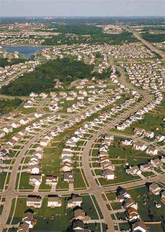
5 What Can We Expect? GREEN INFRASTRUCTURE
6 Conservation Corridor Planning in Northern Virginia GREEN INFRASTRUCTURE Refine state analyses using local data and priorities. Identify & map high value cores and corridors across the region. Highlight opportunities for regional connections. Quantify benefits of these areas. Develop specific themed overlay maps to highlight relationship of green infrastructure and uses Develop model language for incorporation of GI/CC into local planning efforts. Develop communication products and strategy for promoting conservation opportunities to elected officials and the public.
7 Green Infrastructure Principles

: the")


8 Infrastructure: What s in a name? Infrastructure (n): the substructure or underlying foundation on which the continuance and growth of a community or state depends.
 (right). Source: American Forests")
9 What is Green Infrastructure? A planimetric map of a Washington DC shows a neighborhood s gray infrastructure including buildings and roads (left). Classified high-resolution satellite imagery adds a green infrastructure data layer (trees and other vegetation) (right). Source: American Forests
10 Green Infrastructure Principles An interconnected network of a wide range of landscape elements that support native species, maintain natural ecological processes, sustain air and water resources, and contribute to the health and quality of life for communities and people. Source: Green Infrastructure: Linking Landscapes and Communities, Benedict and McMahon (2006)


11 Green Infrastructure Network GREEN INFRASTRUCTURE A green infrastructure network is made up of connected core habitats and connecting corridors that help animals, seeds, and people move across the landscape.

12 Larger patches = large benefits more interior species, larger populations, more habitat types Smaller patches = supplemental benefits act as stepping stones for species movement Image source: Dramstad, Wenche E., et al. Landscape Ecology Principles in Landscape Architecture and Land Use Planning. Washington D.C., Island Press, 1996.


13 Who prefers interior forest cores? Birds, e.g. cerulean warbler, Scarlet tanager Mammals, e.g. black bear, bobcat, n. flying squirrel Amphibians, e.g. spotted salamander GREEN INFRASTRUCTURE


14 Which forests intact now and future? Small parcels fragment forest into many owners Large parcels create contiguous forest blocks We use local parcel data to determine current and future intactness. Timber Asset = Contiguous Large Forested Parcels (>20 acres). A wildlife asset = > 100 acres

15 Benefits of Conserving Green Infrastructure Combating global warming (carbon sequestration) and improving air quality. Protects and preserves water quality and supply. Provides stormwater management, hazard mitigation. Preserves biodiversity and wildlife habitat. Improves quality of life and fitness by access to recreation. GREEN INFRASTRUCTURE
16 Where to develop? Smart Growth = Using Existing (grey) Infrastructure But is this enough?
17 Typical Plan = Save ½ Build ½ While this approach is simple, it does not conserve our best resources.
18 Need to consider: What are all the assets? Grey + Green = Smart + Green

19 Here s the problem when cluster developments don t look outside the parcel: GREEN INFRASTRUCTURE

20 Green infrastructure approach helps keep corridors intact. Undeveloped parcel: PDR, TDR, Easement?
21 Virginia s Comprehensive Planning Comp Plans reviewed at least once every 5 years. careful and comprehensive surveys and studies of the existing conditions and trends of growth, and of the probable future requirements of its territory and inhabitants. guiding and accomplishing a coordinated, adjusted and harmonious development which will, in accordance with present and probable future needs and resources, promote the health, safety, morals, order, convenience, prosperity and general welfare of the inhabitants Zoning must be in accordance with comprehensive plans so comp plans should include maps of key natural assets.

22 GI Planning Steps 1) Asset Mapping (what are the existing ecological, cultural and economic assets) 2) Risk Assessment (which of the assets above are at risk) 3) Opportunities (what kind of community do we want? what projects, programs, policies to ensure assets conserved?) 4) Policy Implementation (adoption of asset maps, strategy maps, integrate into comprehensive plans, park plans etc.)
23 Green Infrastructure Planning Applications Park and open space planning Identify lands for PDR or TDR programs New ordinance development Species protection Heritage tourism and viewsheds Ag and Forestal Districts Transportation planning: roads/trails Public Regulatory Private Voluntary
24 In Summary, Green Infrastructure Planning Helps localities make better decisions about where, when and how to grow. Strengthens and integrates existing planning efforts. Provides an inventory of natural assets that are critical to healthy communities. Protects valuable community resources and character. Makes economic sense = smart green growth!
25 New Virginia Modeling Tools VA Natural Landscape Assessment Forest Habitats Cultural Model Historic Resources Vulnerability Model -- -Growth predictions and threats Forest Economics Model Economically viable forests Agricultural Model Lands suitable for farming Recreation Model Trails, Parks, Hunting and Fishing Watershed Integrity Model Ecological Integrity Priority Conservation Assessment (multiple species) GREEN INFRASTRUCTURE For general information: For simple maps:
26 VaNLA GREEN INFRASTRUCTURE
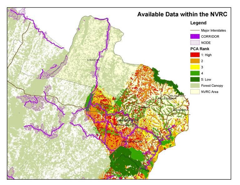
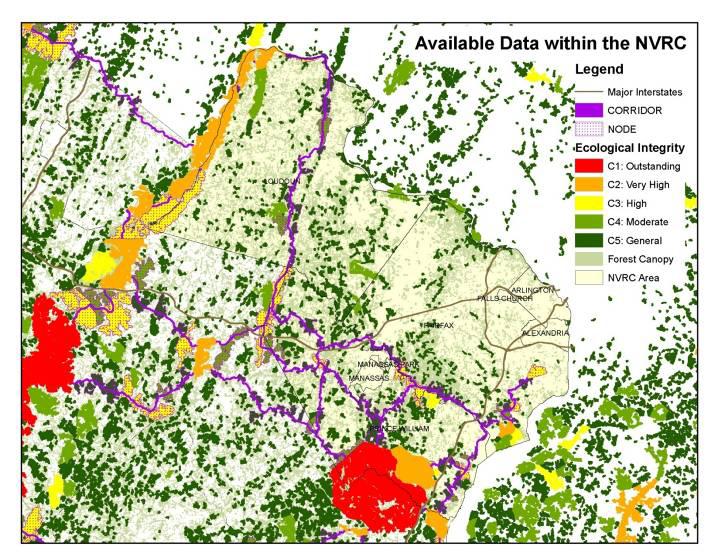
27 PCA GREEN INFRASTRUCTURE
28 High Priority Conservation Areas + Connected, Good Quality Landscapes + Contributing Landscapes Base Green Infrastructure Network
29 Developing a Northern Virginia Base Map Data Sources Virginia Department of Forestry Land Cover & Forest Cover Virginia Department of Conservation and Recreation VaNLA, Conserved Lands USGS National Hydrology Dataset FWS National Wetland Inventory Local GIS Managers CBPA, streams, parks, etc.
30 Layer Source GREEN INFRASTRUCTURE Base Green Infrastructure Network High Value Cores Natural Land Network Contributing Landscapes Tree Canopy Land Cover Rural Lands Urban Developed Lands Major Rivers Lakes/Ponds Streams NVRC DCR-DNH DCR-DNH VDOF VDOF (2005) USGS - NHD USGS - NHD USGS - NHD Neighbors Stafford County Cores DC Maryland GreenPrint State Forest Cover Northern Virginia Region Boundary Roads GWRC NVRC MD DNR VDOF NVRC VDOT
31 High value resources currently unprotected? Opportunities to expand buffer along conserved lands? DRAFT
32 An example of a cross-county opportunity DRAFT


 87.4 percent (738.")
33 845 acres acres of Tier 1 Habitat DoI = 300 acres 4 Elements of Occurrence Loudoun County GREEN INFRASTRUCTURE Fairfax County % Tree Canopy Lbs of Air Pollutants removed Tons of Carbon Stored Tons of Carbon Sequestered Cu. Ft of Stormwater Retained (estimated) 87.4 percent (738.8 acres) 74,416 ($199,246) 31, ,832,337 cu. ft ($28,994,024)
34 What is a theme? Essentially a theme refers to the a type of information that we want to overlay on the base map to see new relationships. Any land use issue could be come a theme. The purpose is to highlight new relationships. To use for planning and prioritizing conservation. Could also be used to look for conflicts or challenges. Themes determined for this project include, agriculture, nature based recreation, heritage and water resources. Wildlife and forest habitats are included within the base map. Following are some examples from other projects

35 New Kent County 2007

36 Watershed Protection: Riparian Corridors GREEN INFRASTRUCTURE
 and areas needing special attention for")
37 Accomack County: Priority habitat and wildlife conservation areas. Protected or least likely to change (purple) and areas needing special attention for conservation (green).

38 Accomack County: fishery and recreation economy Components include: Water access Watersheds SAV Oyster, clam beds Fishery mgmt. areas

39 Accomack Storm Surge Zones GREEN INFRASTRUCTURE

40 Green Assets: Water GREEN INFRASTRUCTURE

41 Green Assets: Water - Challenges GREEN INFRASTRUCTURE

42 Green Assets: Water - Recommendations Protect forested land adjacent to headwaters Increase forest cover adjacent to proposed reservoir by 200%. Restrict steep slope development.

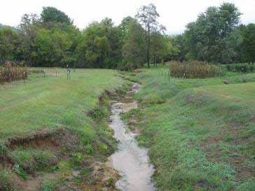
43 Green Assets: Water - Recommendations Protect riparian buffer along wildlife corridor waterways. Concentrate stream bank restoration along impaired waterways lacking forest cover.

44 Green Assets: Water - Recommendations Require developers to mitigate tree removals. Restore or conserve the riparian buffer in urban areas. Require LID for all development + redevelopment.
45 End Northern Virginia Regional Commission Green Infrastructure Center
Conservation Corridor Base and Thematic Maps
 Conservation Corridor Base and Thematic Maps August 20, 2010 This project is funded in part by the Virginia Coastal Zone Management Program at the Department of Environmental Quality through Grant #NAO9NOS4190163
Green Infrastructure Policies and Ordinances
 Green Infrastructure Policies and Ordinances October 23, 2013 By Karen Firehock, Green Infrastructure Center 2013 Georgia Urban Forest Council s 23 rd Annual Conference The mission of the nonprofit Green
Blue/Green Infrastructure Study Accomack County, VA
 Blue/Green Infrastructure Study Accomack County, VA Draft Asset Maps March 8-9, 2010 Green Infrastructure Center, Inc. 2 Overview What is Green and Blue Infrastructure Project Timeline & Tasks Literature
Using Green Infrastructure Planning To Support And Enhance Healthy Ecosystems and Communities
 Using Green Infrastructure Planning To Support And Enhance Healthy Ecosystems and Communities by Karen Firehock, Executive Director Green Infrastructure Center Inc. www.gicinc.org A Presentation to Master
Green Infrastructure. by Karen Engel, NYS DEC. NYS Department of Environmental Conservation
 Green Infrastructure by Karen Engel, NYS DEC What is Green Infrastructure? For some it s all about water Green Infrastructure techniques use soils and vegetation to infiltrate, evapotranspirate, and/or
Map Development 5/15/2012. New Virginia Modeling Tools
 Regional Green Infrastructure Base Map Development 5/15/2012 RRRC Land Use & Environment Committee New Virginia Modeling Tools VA Natural Landscape Assessment Forest Habitats Cultural Model Historic Resources
Green (and blue) Infrastructure Planning in VA
 Infrastructure Planning in VA") Green (and blue) Infrastructure Planning in VA Presentation to Rural Resiliency Forum By Karen Firehock Oct. 23, 2018 Green Infrastructure Center 2018 Slide Show Topics Definitions: Resilience Green Infrastructure
Green (and blue) Infrastructure Planning in VA Presentation to Rural Resiliency Forum By Karen Firehock Oct. 23, 2018 Green Infrastructure Center 2018 Slide Show Topics Definitions: Resilience Green Infrastructure
Countywide Green Infrastructure
 Montgomery County s Countywide Green Infrastructure F U N C T I O N A L M A S T E R P L A N The Maryland National Capital Park and Planning Commission INFRASTRUCTURE An underlying base or foundation especially
Green Planning in Albemarle and Charlottesville
 Green Planning in Albemarle and Charlottesville Presentation to League of Women Voters February 10, 2019 By Karen Firehock, Executive Director Green Infrastructure Center 2019 The Green Infrastructure
National Association of Conservation Districts. Kris Hoellen Vice President, Sustainable Programs The Conservation Fund September 19, 2013
 National Association of Conservation Districts Kris Hoellen Vice President, Sustainable Programs The Conservation Fund September 19, 2013 Our Mission The Conservation Fund forges partnerships to conserve
Virginia DCR- Natural Heritage Program. Tools for Linking Conservation and Transportation Planning
 Virginia DCR- Natural Heritage Program Tools for Linking Conservation and Transportation Planning November 9, 2009 MISSION: to conserve Virginia's biodiversity through statewide biological inventory, protection,
Town of Peru Comprehensive Plan Executive Summary
 Town of Peru Comprehensive Plan Executive Communities that plan grow by choice, not by chance. A plan makes growth thoughtful, understandable, and predictable. A plan shows that a community is managing
Green Infrastructure. NYS Department of Environmental Conservation
 Green Infrastructure Green infrastructure is an interconnected network of natural areas and open spaces that sustains ecosystems. Benedict, M.A. and E.T. McMahon. 2006. Green Infrastructure Linking Landscapes
Community Conservation Workshop. Lake Placid
 Community Conservation Workshop Lake Placid 2 Community Conservation Program Welcome! We have designed a Community Conservation Program that listens to the needs of community members. We are conducting
Minnesota Department of Natural Resource - Natural Resource Guidance Checklist Conserving Natural Resources through Density Bonuses
 Minnesota Department of Natural Resource - Natural Resource Guidance Checklist Conserving Natural Resources through Density Bonuses NRDB Why Use Density Bonuses & This Checklist Local units of government
WASHINGTON COUNTY OREGON
 WASHINGTON COUNTY OREGON LONG RANGE PLANNING DIVISION North Bethany Subarea Stream Corridors: Existing Regulations In Oregon, there is a distinct difference between the land use rules that apply in rural
Oakland County s Green Infrastructure Vision. L. Brooks Patterson Oakland County Executive
 Oakland County s Green Infrastructure Vision L. Brooks Patterson Oakland County Executive Southeast Michigan 20 miles northwest of Detroit Consists of 910 square miles Population of 1.2 million More than
Staff will be providing an overview of the project need, purpose and intent for consideration as part of the Amendment cycle.
 Agenda Item D-2 City of Tacoma Planning and Development Services To: Planning Commission From: Stephen Atkinson, Planning Services Division Subject: Open Space Corridors Project Meeting Date: March 1,
Planning for and Managing Open Space and Natural Areas
 Planning for and Managing Open Space and Natural Areas Increasingly, development proposals in Delaware include large amounts of open space and natural areas. While open space is important as a community
COMMUNITY ENVIRONMENTAL MANAGEMENT
 COMMUNITY ENVIRONMENTAL MANAGEMENT CEM HANDBOOK FOR COMMUNITY CONSERVATION PLANNING ----- Draft ----- Prepared by the CENTER FOR COMMUNITY ENVIRONMENTAL MANAGEMENT in association with the NEW YORK STATE
Benchmark Nonpoint Source Management Approaches In Other States
 Governor s Environmental Advisory Council 2007 Nonpoint Source Pollution Control Initiative Benchmark Nonpoint Source Management Approaches In Other States Governor s Environmental Advisory Council April
Community Conservation Workshop. Saranac River Basin Communities
 Community Conservation Workshop Saranac River Basin Communities 2 Community Conservation Program Welcome! We have designed a Community Conservation Program that listens to the needs of community members.
One County s Success in Linking Watershed Protection and Land Use Planning
 One County s Success in Linking Watershed Protection and Land Use Planning Bob Thompson Porter County Plan Commission March 28, 2012 Indiana Watershed Leadership Academy Population 160,000 Approximately
Protecting Farmland. The Future of Agriculture in Prince George s County
 Protecting Farmland As demonstrated in the previous section, farmland in Prince George s County is disappearing at a rapid pace. If the loss of farmland continues at this rate, no farmland will be left
Preface. Erie. Scranton. Allentown. Pittsburgh. Harrisburg. Philadelphia
 The Southern Alleghenies Region The Southern Alleghenies Region spans the Laurel Highlands and Allegheny Front in the west across the Appalachians to the east. It is comprised of Blair, Bedford, Cambria,
NEW GRANTS PROGRAM. Today I will describe what green infrastructure planning entails, how the model works and the importance of the work to planners!
 NEW GRANTS PROGRAM The South Carolina Forestry Commission received funds from the USDA Forest Service s Southern Region to build a green infrastructure landscape scale model and to fund several implementation
City of Missoula and Missoula County Open Space Planning Open House
 City of Missoula and Missoula County Open Space Planning Open House FEBRUARY 6, 2018 The following slides contain the display board content from the open house. Please use boards to answer questions in
Riparian Buffer on the Bushkill Creek. Policies
 Riparian Buffer on the Bushkill Creek Riparian buffers provide numerous benefits to landowners and the community by protecting groundwater recharge areas, providing flood control, providing stormwater
Gloucester County s Comprehensive Plan. The Community Connection
 Gloucester County s Comprehensive Plan The Community Connection Current Comp Plan Adopted in 1991 with a 20 year planning horizon Updated in 1995 with Part V- Implementation Recommendations and Appendix
systems is available on the Colorado Wetland Information Center (CWIC) website.
 website.") Colorado Natural Heritage Program Wetland Program Plan -- Dec 2015 Status Update and Addendum -- The Colorado Natural Heritage Program (CNHP) developed a Wetland Program Plan (WPP) in 2010 for the planning
Colorado Natural Heritage Program Wetland Program Plan -- Dec 2015 Status Update and Addendum -- The Colorado Natural Heritage Program (CNHP) developed a Wetland Program Plan (WPP) in 2010 for the planning
Chapter 5: Natural Resources and Environment
 NATURAL RESOURCES AND ENVIRONMENT 5-1 5 Chapter 5: Natural Resources and Environment BACKGROUND AND INTENT Urban expansion represents the greatest risk for the future degradation of existing natural areas,
SECTION II SECTION II STATEMENT OF GOALS, OBJECTIVES, PRINCIPLES, ASSUMPTIONS, POLICIES AND STANDARDS
 STATEMENT OF GOALS, OBJECTIVES, PRINCIPLES, ASSUMPTIONS, POLICIES AND STANDARDS 1 2 STATEMENT OF GOALS, OBJECTIVES, PRINCIPLES, ASSUMPTIONS, POLICIES AND STANDARDS INTRODUCTION The New Jersey Municipal
CHAPTER 4 FUTURE LAND USE AND URBAN SERVICES DISTRICTS
 CHAPTER 4 FUTURE LAND USE AND URBAN SERVICES DISTRICTS Introduction This chapter discusses how Benzie County should grow and change in the future. A community can grow and change in many different ways.
COMMUNITY DESIGN. GOAL: Create livable and attractive communities. Intent
 COMMUNITY DESIGN Intent An attractive, well-designed County will attract quality development, instill civic pride, improve the visual character of the community, and create a strong, positive image for
GIS to Estimate Archaeological Site Loss and Develop Conservation Strategies
 GIS to Estimate Archaeological Site Loss and Develop Conservation Strategies Terry Jackson Office of Decision Support Systems Planning and Environmental Management Division Georgia Department of Community
Table of Contents TABLE OF CONTENTS SECTION TITLE PAGE
 TABLE OF CONTENTS SECTION TITLE PAGE 1 INTRODUCTION AND OVERVIEW 1-1 1.1 Purpose and Need 1-1 1.2 Goals and Objectives 1-3 1.3 Overview of the Planning Process 1-5 1.4 Federal and State Requirements and
CONSERVATION ELEMENT GOALS, OBJECTIVES, AND POLICIES
 CONSERVATION ELEMENT GOALS, OBJECTIVES, AND POLICIES Goal 4 To conserve, manage, appropriately use and protect the natural resources of the City ensuring continued resource availability and environmental
Presentation Outcomes
 Green Infrastructure Rappahannock-Rapidan Living Lands Planning Workshop September 17, 2009 Presentation Outcomes Define green infrastructure principles and concepts (video). How are green infrastructure
Greenways as an alternative to traditional infrastructure. Green Infrastructure
 Greenways as an alternative to traditional infrastructure Green Infrastructure What is a Greenway? Little (1990) - A linear open space along a natural or human made corridor. Fabos - linked corridors nature
Regional Open Space Conservation Plan. Regional Staff Committee January 18, 2018
 Regional Open Space Conservation Plan Regional Staff Committee January 18, 2018 Schedule We are here Task 1 - Stakeholder Input & Work Plan Dev. v z 2016 2017 2018 Oct Nov Dec Jan Feb Mar Apr May Jun Jul
Arlington, Virginia is a worldclass
 EXECUTIVE S U M M A RY Arlington maintains a rich variety of stable neighborhoods, quality schools and enlightened land use policies, and received the Environmental Protection Agency s highest award for
TOWN OF SPRINGFIELD, NEW HAMPSHIRE
 TOWN OF SPRINGFIELD, NEW HAMPSHIRE NATURAL RESOURCES INVENTORY EXECUTIVE SUMMARY March 2008 Prepared by: Watershed to Wildlife, Inc. Natural Resource Consultants 42 Mill Street, Suite 3 Littleton, NH 03561
Article 6 Tree Protection
 Article 6 Tree Protection 8.1 Purpose 8.2 Applicability 8.2.1 General Provisions 8.2.2 Exemptions 8.3 Permitting Procedure 8.4 Planting Procedure 8.5 Performance Guarantee Required for Belated Planting
TOWN OF BETHLEHEM OPEN SPACE CONSERVATION PLAN PUBLIC MEETING: OCTOBER 12, 2017
 TOWN OF BETHLEHEM OPEN SPACE CONSERVATION PLAN PUBLIC MEETING: OCTOBER 12, 2017 Welcome and Agenda 6:00 6:45: Open House, Part One 6:45 7:15: Presentation and Questions 7:15 8:00: Open House, Part Two
Rural Land Use Designations Kittitas County December 6, 2007 Draft
 KITTITAS COUNTY COMMUNITY DEVELOPMENT SERVICES 411 N. Ruby St., Suite 2, Ellensburg, WA 98926 CDS@CO.KITTITAS.WA.US Office (509) 962-7506 Fax (509) 962-7682 Rural Land Use Designations Kittitas County
RECREATION, OPEN SPACE AND GREENWAYS ELEMENT GOALS, OBJECTIVES, AND POLICIES
 RECREATION, OPEN SPACE AND GREENWAYS ELEMENT GOALS, OBJECTIVES, AND POLICIES GOAL R-1: DEVELOP A RECREATION, OPEN SPACE AND GREENWAYS SYSTEM AS AN INTEGRAL COMPONENT OF AN OVERALL, COUNTY-WIDE ECONOMIC
Planning for Staten. Habitat Restoration and Green Infrastructure. Island s North Shore
 Habitat Restoration and Green Infrastructure Planning for Staten Island s North Shore Community Board 1 March 1, 2018 NYC Parks Forestry, Horticulture, and Natural Resources Funded by the NYS Department
Working Group Meeting
 April 4,, 2017 Parks Operations Bldg Working Group Meeting Arts Districts Overview Stormwater/RPA/Stream Considerations First Principles Agenda 7:00pm 7:05pm 7:10pm 7:40pm 8:30pm 9:40pm 9:45pm Welcome
DRAFT MAP AMENDMENT FLU 04-4
 DRAFT MAP AMENDMENT FLU 04-4 SW 24 TH AVENUE ROADWAY CORRIDOR The University of Florida participates with the Metropolitan Transportation Planning Organization (MTPO) in its responsibilities for the continuing,
Exhibit A. 8:9 Scuffletown Rural Conservation District
 Exhibit A 8:9 Scuffletown Rural Conservation District 8:9.1 Intent and Purpose The Scuffletown Rural Conservation (SRC) District is intended to provide for residential development that supports the development
3-2 Environmental Systems
 3-2 Environmental Systems 3.0 ENVIRONMENTAL SYSTEMS CONTENTS 3.1 GREENWAY SYSTEM 3.1.1 General Policies 3.1.2 Natural Heritage Network 3.1.3 Natural Heritage Network Enhancement Lands 3.1.4 Rouge Watershed
Executive Summary Purpose of the Plan Defining Open Space and Greenways
 Executive Summary Bucks County possesses a vast array of open space resources including natural areas, parks, farmland and historic and cultural resources that contribute to a high quality of life valued
PSRC REVIEW REPORT & CERTIFICATION RECOMMENDATION
 PSRC REVIEW REPORT & CERTIFICATION RECOMMENDATION KITSAP COUNTY COUNTYWIDE PLANNING POLICIES July 2, 2012 BACKGROUND A major emphasis of the Washington State Growth Management Act (GMA) is the need to
Chapter 10 IMPLEMENTATION RECOMMENDATIONS
 Chapter 10 IMPLEMENTATION RECOMMENDATIONS The recommended land use plan presented in the previous chapter provides a design for the attainment of the urban and rural development and open space preservation
Albion Hills Conservation Area Master Plan. Public Information Session
 Albion Hills Conservation Area Master Plan Public Information Session 1 03.25.2014 Meeting Agenda 1. Project Introduction Property History Current Use Master Plan Process 2. Draft Vision Goals and Objectives
Shared History, Shared Future
 Open Space is Shared History, Shared Future Builds upon past and current regional planning: PSP Action Agenda, Vision 2040, the Cascade Agenda, and Mountains to Sound Greenway The ROSS Approach Building
{Best Practices. Summary of Tools, Strategies and Best Practices from 11 Michigan Case Study Communities
 Case Studies Michigan Coastal Community Working Waterfronts { Summary of Tools, Strategies and from 11 Michigan Case Study Communities Table of Contents Zoning...2 Community and Stakeholder Collaboration
Woodland Conservation and the Master Plan
 1 WHAT IS A MASTER PLAN? A Vision for the Future of Your Community Woodland Conservation and the Master Plan Goals Objectives Strategies 2 How Will Your Community Look? TREE PRESERVATION AND THE MASTER
An Introduction to the Far North Land Use Strategy
 An Introduction to the Far North Land Use Strategy December, 2013 Ministry of Natural Resources Table of Contents PREFACE... 3 About the Far North... 3 Evolution of Land Use Planning in the Far North...
Whitemarsh Township Greenway Plan
 Whitemarsh Township Greenway Plan Prepared for: Whitemarsh Township August 16, 2007 Table of Contents Table of Contents... i Introduction... 1 Study Area Setting... 2 Regional Setting... 2 Township Character...
Environment and Sustainability. Environment and Sustainability
 4 Environment and Sustainability Environment and Sustainability ENVIRONMENT AND SUSTAINABILITY 4.1 CLIMATE CHANGE AND AIR QUALITY... 4-5 4.1.1 OBJECTIVES... 4-6 4.1.2 POLICIES... 4-6 4.2 NATURAL HERITAGE
INTEGRATING PROTECTED AREAS INTO THE WIDER LANDSCAPE, SEASCAPE AND RELATED SECTORS. An Overview
 INTEGRATING PROTECTED AREAS INTO THE WIDER LANDSCAPE, SEASCAPE AND RELATED SECTORS An Overview USING AN EXAMPLE FROM NORTHEAST US Relationship of IPAWLS guide to other planning and assessment processes
THREE-STEP DESIGN PROCESS FOR OPEN SPACE SUBDIVISIONS
 00216106.DOC NMA/RRK 1/30/14 THREE-STEP DESIGN PROCESS FOR OPEN SPACE SUBDIVISIONS Open space subdivisions, sometimes called cluster developments, maintain a significant portion of a development site in
Aquatic, Terrestrial and Landscape Conservation Design Tools and Products of the North Atlantic LCC
 Aquatic, Terrestrial and Landscape Conservation Design Tools and Products of the North Atlantic LCC Scott Schwenk Science Coordinator, North Atlantic LCC Chesapeake Bay FWS Partners Meeting Annapolis,
Public Review Draft Oceanside Subarea Habitat Conservation Plan/ Natural Communities Conservation Plan
 Oceanside Subarea Habitat Conservation Plan/ Natural Communities Conservation Plan Prepared for City of Oceanside Planning Department 300 N. Coast Highway Oceanside, CA 92054 Prepared by Ogden Environmental
GREEN NETWORK APPLICATIONS IN ESTONIA
 GREEN NETWORK APPLICATIONS IN ESTONIA Kalev Sepp, Tuuli Veersalu, Martk Külvik Estonian University of Life Sciences 1 WHY? BACKGROUND - POLITICAL By adopting the Pan-European Biological and Landscape Diversity
Green Infrastructure Planning for Sustainability and Resiliency
 Green Infrastructure Planning for Sustainability and Resiliency Linking Lands and Communities in the Land-of-Sky Region SAMAB Conference - November 18, 2010 www.linkinglands.org Linda Giltz, AICP, Regional
Recommendations for Municipalities
 Protecting the Kayaderosseras Creek through Better Buffers Recommendations for Municipalities Conservation Committee October 2005 Introduction The Kayaderosseras Creek is a superb natural resource that
PRESENTATION ON JOHANNESBURG S BIODIVERSITY PROGRAMME
 PRESENTATION ON JOHANNESBURG S BIODIVERSITY PROGRAMME Member of Mayoral Committee: Cllr Prema Naidoo Environmental Management & Johannesburg City Parks PRESENTATION OVERVIEW Jo burg Overview & Context
The City shall enhance and improve the accessibility of parks and recreational facilities while protecting their quality. by:
 GOALS, OBJECTIVES AND POLICIES GOAL 1: To provide open space and recreation as an essential element needed for the betterment of the City s character and quality of urban life. The City shall plan for
Portage County Parks, Trails and Greenways Plan
 Portage County Parks, Trails and Greenways Plan Agenda for Local Planning Meeting Introductory Presentation Why we need a Plan Plan project goals and process Benefits Overview of local planning region
Brockton. Produced in This report and associated map provide information about important sites for biodiversity conservation in your area.
 CONSERVING THE BIODIVERSITY OF MASSACHUSETTS IN A CHANGING WORLD Brockton Produced in 2012 This report and associated map provide information about important sites for biodiversity conservation in your
2018 Northampton Township Comprehensive Plan
 2018 BUCKS COUNTY, PENNSYLVANIA What is a? A comprehensive plan is a municipality s main policy document that details the collective vision for the future, the historic, environmental, and cultural facilities
Stafford County Strategic Plans
 Stafford County Strategic s Strategic Department Description Date Adopted Board of Supervisors Priorities Fiscal Responsibility Education Public Safety Infrastructure Economic Development Service Excellence
City of Tacoma Planning and Development Services
 Agenda Item D-1 City of Tacoma Planning and Development Services To: Planning Commission From: Elliott Barnett, Planning Services Division Subject: Application #2014-08 Open Space Element Update Meeting
Location. Need GOAL 14 URBAN GROWTH BOUNDARY. Urban Planning in Oregon 7/8/2015
 Urban Planning in Oregon June 24, 2015 Redmond, Oregon Gordon Howard, DLCD Urban Planning Specialist GOAL 14 URBAN GROWTH BOUNDARY To provide for an orderly and efficient transition from rural to urban
I. STAFF POLICY RECOMMENDATIONS. The following RMP policy strategies are proposed by staff in support of a Scenic Resource Protection Program:
 Policy Consideration: Scenic Resource Protection Program Status: For Consideration by the Highlands Council at September 14, 2006 Work session Date: September 12, 2006 I. STAFF POLICY RECOMMENDATIONS The
INTEGRATING PROTECTION OF ECOSYSTEM SERVICES INTO THE PLANNING PROCESS IN FLORIDA
 INTEGRATING PROTECTION OF ECOSYSTEM SERVICES INTO THE PLANNING PROCESS IN FLORIDA Clay Henderson Institute for Water and Environmental Resilience - Stetson University Elizabeth Porter Economics Department,
This page intentionally blank.
 This page intentionally blank. Parks, Recreation, and Open Space Chapter Relationship to Vision Vision Parks, Recreation and Open Space Chapter Concepts County Government. County government that is accountable
Draft Stillwater 2030 Comprehensive Plan- Goals and Policies
 Draft Stillwater 2030 Comprehensive Plan- Goals and Policies Instructions- Review each goal and policy and discuss with group any changes, deletions for additions to the list using your groups pen. Keep
Terra Nova Rural Park Plan
 Terra Nova Rural Park Plan Part 1 Getting to know the land The Surrounding Area North Side Airport, River, Trail East Side - Residential West Side- Sturgeon Banks, West Dyke Trail South Side:Terra Nova
NORTH KINGSTOWN PILOT PROJECT May 9, 2016 North Kingstown Town Council
 Engaging RI Local Governments in Hazard Mitigation and Coastal Resilience NORTH KINGSTOWN PILOT PROJECT May 9, 2016 North Kingstown Town Council Teresa A. Crean, AICP University of Rhode Island Coastal
2016 Comprehensive Plan Amendments C OMPREHENSIVE P LAN T EXT AND M AP A MENDMENT
 2016 Comprehensive Plan Amendments T EXT A MENDMENTS D ISTILLERIES IN R URAL P OLICIES #844110 LID POLICIES #844112 M AP A MENDMENTS B ETHEL S CHOOL D ISTRICT #844237 P ARKS AND R ECREATION #844305 C OMPREHENSIVE
Best Practices Appendix: Waterfront Communities
 Redevelopment Ready Communities Best Practices Appendix: Waterfront Communities revised September 2014 Waterfront RRC defined The purpose of these additional criteria is to provide waterfront communities
INTRODUCING THE BALTIMORE CITY GREEN NETWORK VISION PLAN
 INTRODUCING THE BALTIMORE CITY GREEN NETWORK VISION PLAN GOALS OF THE GREEN NETWORK PLAN Protect and enhance the unique ecological resources of our city Support economic growth and sustainable redevelopment
Chapter 13: Implementation Plan
 Implementation A. Introduction The Implementation Plan, in table form on the following pages, provides a summary of all the Action Items recommended in Chapters 2 through 12. The table also indicates which
Brice Prairie Master Plan
 Brice Prairie Master Plan Town of Onalaska Community Meeting #1 Sand Lake Elementary School January 28, 2006 9 am 11 am Agenda Background What is a Master Plan? Brice Prairie Capacity Reports Starter Ideas
HOT SPRINGS COMPREHENSIVE PLAN OUTLINE
 HOT SPRINGS COMPREHENSIVE PLAN OUTLINE 7/28/2015 Draft outline - Hot Springs Comprehensive Plan Draft outline of topics to be discussed at public hearings and in planning sessions. Order and topics and
IV. Development in the Rural Overlay District
 Intracoastal Waterway Route 17 Route 168 Great Dismal Swamp VIRGINIA NORTH CAROLINA IV. Development in the Rural Overlay District IV-1 Route 17 in Chesapeake s Rural Overlay District affords distant views
Mapping and Planning for Green Infrastructure
 Mapping and Planning for Green Infrastructure Karen Firehock, Executive Director TransportiCA Webinar Series August 30, 2018 Today 1. Green infrastructure defined 2. Mapping green infrastructure in rural
CHATHAM COUNTY S PATH TO SUSTAINABILITY - THE NATURAL RESOURCES SIDE
 CHATHAM COUNTY S PATH TO SUSTAINABILITY - THE NATURAL RESOURCES SIDE GEORGIA ENVIRONMENTAL CONFERENCE SAVANNAH, GEORGIA AUGUST 23, 2012 Jackie Jackson Teel Chatham County-Savannah Metropolitan Planning
STREAM BUFFERS
 88-415 STREAM BUFFERS 88-415-01 PURPOSE In the Kansas City region and throughout the nation, vegetated stream buffers have been clearly shown to protect stream stability and related infrastructure, improve
Cooperative Extension s Role in Land Use Planning and Conservation. Sabrina Drill UCCE- Los Angeles/Ventura Integrated Hardwood Range Mgmt.
 Cooperative Extension s Role in Land Use Planning and Conservation Sabrina Drill UCCE- Los Angeles/Ventura Integrated Hardwood Range Mgmt. Program Cooperative Extension Land Grant Universities: 1862 Agricultural
THE PROTECTION OF CHATHAM COUNTY S NATURAL RESOURCES - THE POLICY SIDE
 THE PROTECTION OF CHATHAM COUNTY S NATURAL RESOURCES - THE POLICY SIDE SEA GRANT TIDAL CREEK SUMMIT CHARLESTON, SOUTH CAROLINA DECEMBER 5, 2011 Jackie Jackson Teel Chatham County-Savannah Metropolitan
2040 LUP is a part of the Comprehensive Plan and carries the same legal authority. Economic Challenges
 1.1. Guiding Anchorage s Growth Where will new residents settle over the next two decades? Where will people work, shop, and play? Will there be enough room to grow? How will Anchorage look? Will growth
Innovative Land Use Techniques
 Innovative Land Use Techniques A Handbook for Sustainable Development Eric Williams, Assistant Administrator, NHDES Carolyn Russell, Principal Planner, NHDES Cliff Sinnott, Executive Director, RPC Jill
4. What are the goals of the Kawarthas, Naturally Connected project? 7. What are watersheds and why are they being used as the project boundaries?
 Frequently Asked Questions (FAQs) 1. What are Natural Heritage Systems (NHS)? 2. Why are they important? 3. Which areas of the province have undertaken NHS projects? 4. What are the goals of the Kawarthas,
DANE COUNTY COMPREHENSIVE PLAN 5-YEAR UPDATE. Madison Area Surveyors March 12, 2014 Resource Protection Corridors
 DANE COUNTY COMPREHENSIVE PLAN 5-YEAR UPDATE Madison Area Surveyors March 12, 2014 Resource Protection Corridors Resource Protection Corridors Part 1: Purposes and Concepts Resource Protection Corridors
Figure 1. Proposed Strategic Habitat Conservation Areas for Florida
 Figure 1. Proposed Strategic Habitat Conservation Areas for Florida Critical Lands and Waters Identification Project (CLIP) Cooperative Effort Century Commission for Sustainable Florida Florida Natural
But What About the People? The Role of Urban Planning and Green Infrastructure
 But What About the People? The Role of Urban Planning and Green Infrastructure The Southeast Conservation Adaptation Strategy: A Model for Collaborative Conservation David Rouse, FAICP, ASLA Managing Director,