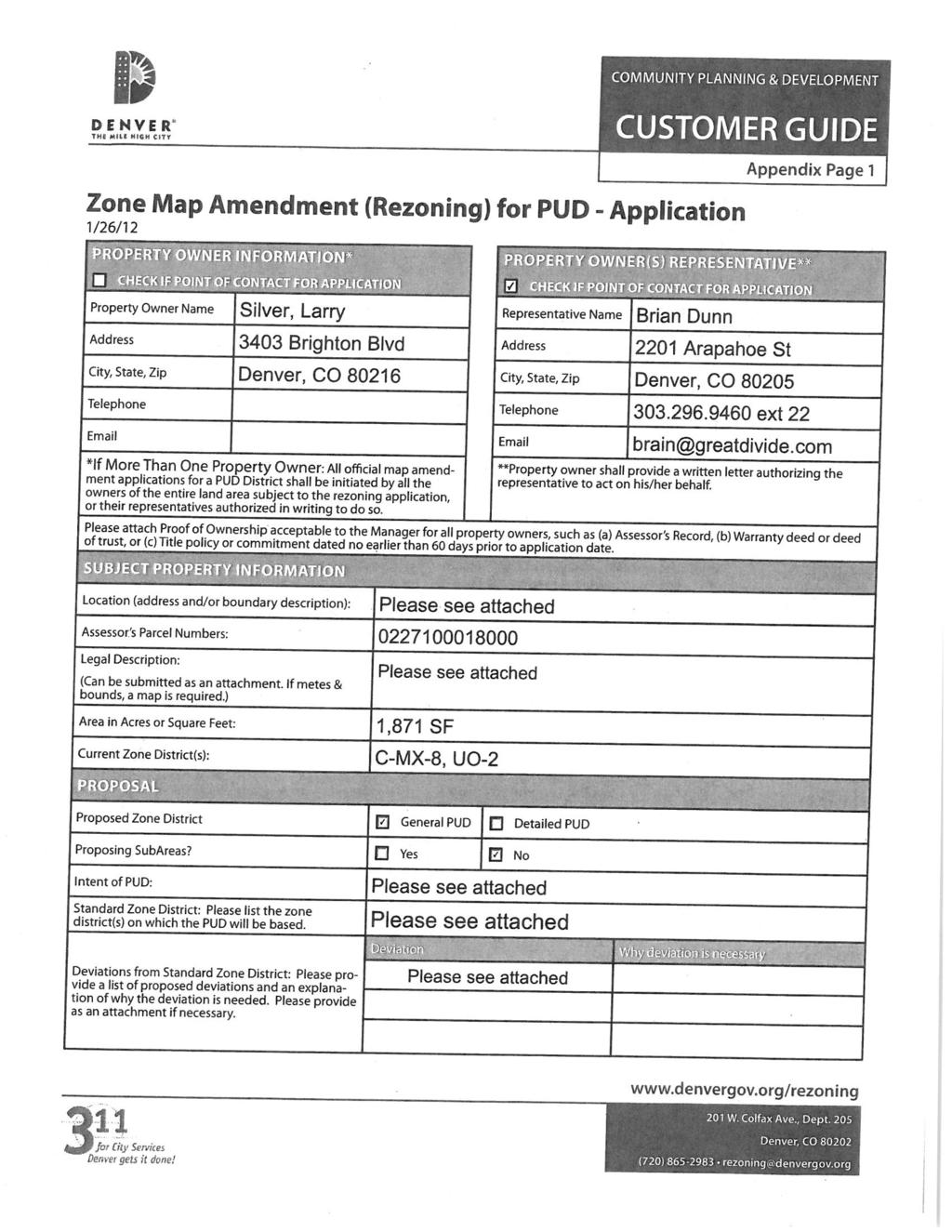
Staff Report and Recommendation
|
|
|
- Lily Wiggins
- 5 years ago
- Views:
Transcription
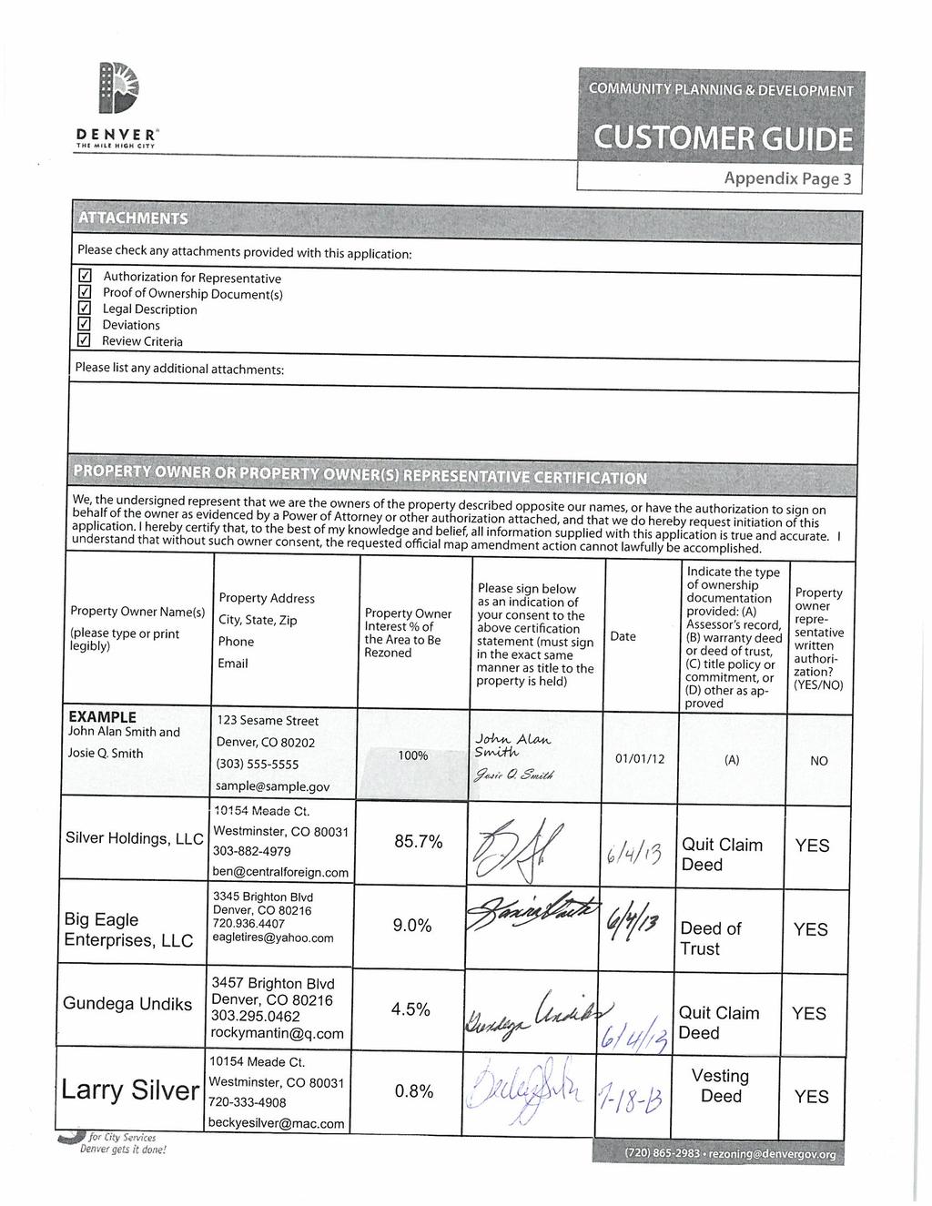
1 Community Planning and Development Planning Services 201 W Colfax Ave, Dept 205 Denver, CO p: f: TO: LUTI FROM: Steve Nalley, Senior City Planner DATE: August 20, 2013 RE: Zoning Map Amendment #2013I , 3403, 3457 Brighton Blvd - Rezoning from C-MX-8, UO-2 to PUD-G, UO-2 Staff Report and Recommendation Based on the criteria for review in the Denver Zoning Code, Staff recommends approval for proposed map amendment #2013I for a rezoning from C-MX-8, UO-2 to PUD-G, UO-2. Request for Rezoning Proposed map amendment: #2013I Address: 3345, 3403, 3457 Brighton Blvd Neighborhood/Council District: Five Points / Council District #9 RNOs: River North Denargo Brighton Blvd Association, United Community Action Network Inc., Elyria Swansea/Globevile Business Association, RiNo - River North Art District, RiNo Neighbors, North Community Congress for Education, Denver Neighborhood Association Inc., Inter- Neighborhood Cooperation Area of property: 5.1 acres Current zoning: C-MX-8, UO-2 Proposed zoning: PUD-G, UO-2 Property owner: Brian Dunn Great Divide Brewing Company Contact person: Brian Dunn


2 Proposed Map Amendment #2013I /20/13 Page 2 Citywide map subject site represented in red. Council district map the subject site is located in Council District #9 and is represented in red.

3 Proposed Map Amendment #2013I /20/13 Page 3 Neighborhood map the subject site is located in the Five Points neighborhood and is represented in red.

4 Proposed Map Amendment #2013I /20/13 Page 4 Summary of Rezoning Request The properties proposed for rezoning are generally located between what would be 33 rd St. and 35 th St. along the north west side of Brighton Blvd. The site is made up of multiple property owners and uses.


5 Proposed Map Amendment #2013I /20/13 Page 5 The corner of 35 th and Brighton is an industrial use, Rocky Mountain Retinning. See image below. Image source: Google, image date: August 2011 Moving south along Brighton is an auto recycling use, Central Foreign Auto Parts. See image below. Image source: Google, image date: August 2011 Continuing south along Brighton Blvd. is an automobile services use, Eagle Tires. Image source: Google, image date: August 2011

6 Proposed Map Amendment #2013I /20/13 Page 6 The general purpose of this PUD-G is to allow for an expanded mix of uses including industrial uses, in a building form that contributes to the planned vision for the River North neighborhood and the Brighton Boulevard corridor. The specific intent of this PUD-G is to: allow the I-MX-8 zone district uses with a modification of limitations on brewing, malt beverage, wines, brandy, distilled and blended spirits manufacturing uses; utilize the Urban Center Neighborhood Context and the C-MX-8 Zone District building form standards; and establish additional building form standards to anticipate planned infrastructure improvements surrounding the PUD-G site, such as a future park space along the South Platte River, Arkins Court street realignment, and a potential new connection along 35 th St. (See map below for additional details). The map below highlights City projects immediately adjacent to the site. These projects include a planned future park; a realigned Arkins Ct.; 35 th St. as an improved connection to the 38 th and Blake station and across the S. Platte River; a new outfall and a potential street at 33 rd ; and a new Brighton Blvd street cross section. These projects have varying timeframes, planning, level of design and funding sources. The proposed PUD-G requires a high level of ground story activation, creating a pedestrian friendly environment along a realigned Arkins Ct., 35 th St and along Brighton Blvd. See the attached Draft PUD-G for specific standards.
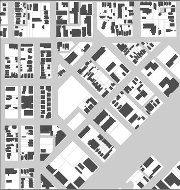
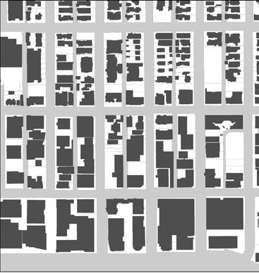
7 Proposed Map Amendment #2013I /20/13 Page 7 Existing Context The following table summarizes the existing context proximate to the subject site: Existing Block, Lot, Street Existing Zoning Existing Land Use Blueprint Denver Pattern Mixed Use Area Incomplete grid of Site C-MX-8, UO-2 Industrial of Change streets; Block sizes and North Mixed Use Area shapes are inconsistent, C-MX-12, UO-2 Retail/industrial/office east of Change but mostly rectangular. South Mixed Use Area Vehicle parking is in the C-MX-12, UO-2 Industrial west of Change front, rear or side of South Mixed Use Area buildings with mixed alley I-MX-8, UO-2 Industrial east of Change access. North west I-MX-5, UO-2 Vacant owned by the city for future planned park space/bicycle impound Mixed Use Area of Change 1. Existing Zoning The existing zoning for the site is C-MX-8, UO-2, approved in 2010 as part of the new zoning code effort. Prior to the new code, the site was zoned I-2, heavy industrial. The current zoning allows mixed use development up to 8 stories and requires a high level of ground story activation, but allows very few industrial uses. The UO-2 portion of the zone district is a use overlay allowing billboards. 2. Existing Land Use Map The existing land use of the subject site is industrial. The uses on site range from automobile services, warehouse, auto recycling, and fabrication. Transition from predominately industrial uses to mixed-use and creative spaces has ensued in River North over the past decade, with the addition of art galleries, multifamily residential development and commercial office space. The transition also incorporates a healthy mix of existing and new industrial uses.


8 Proposed Map Amendment #2013I /20/13 Page 8 Existing Zoning Map Existing Land use Map


9 Proposed Map Amendment #2013I /20/13 Page 9 3. Existing Building Form and Scale Looking south west along Brighton Blvd. Image source: Google, image date: August 2011 Looking north east along Brighton Blvd. Image source: Google, image date: August 2011 Looking north west along 35 th St. Image source: Google, image date: August 2011
10 Proposed Map Amendment #2013I /20/13 Page 10 Summary of City Agency Referral Comments As part of the DZC review process, the rezoning application is referred to potentially affected city agencies and departments for comment. A summary of agency referral responses follows: Asset Management: Approve No comments. Denver Fire Department: Approve Rezoning Only will require additional information at site plan review. Development Services Wastewater: Approved DS Wastewater has no objection to the rezone; however applicant should be under notice that Public Works will not approve any development of this property without assurance that there is sufficient sanitary and storm sewer capacity. A sanitary study and drainage study may be necessary. These studies may results in a requirement for the developer to install major infrastructure improvements or a limit to development if current infrastructure is insufficient. Development Services Project Coordinator: Conditional Please continue to work through the site planning process. Development Services Transportation: Approved DS Transportation approves the subject zoning change. The applicant should note that redevelopment of this site may require additional engineering, ROW dedication to the City, access changes, traffic studies and/or right of way improvements. The extent of the required design and improvements will be determined once this property begins the redevelopment process. The results of any traffic studies may require the construction of off-site mitigation or may limit the proposed density of the project. Denver Parks and Recreation: Approved Forestry Comments Rezoning is approved. As site is redeveloped; refer to Landscape Planning Checklist for formal submittal landscape plan requirements. Checklist can be accessed via Forestry website: ( rytrees/landdeveloperresources/tabid/443717/default.aspx). Public Works City Surveyor: Approved No comment Public Review Process CPD staff provided Informational notice of receipt of the rezoning application to affected members of City Council and registered neighborhood organizations on July 23, Planning Board notification process o The property was legally posted for a period of 15 days announcing the August 7, 2013 Denver Planning Board public hearing, and written notification of the hearing was sent to all affected registered neighborhood organizations and City Council members. LUTI notification process:
11 Proposed Map Amendment #2013I /20/13 Page 11 o Written notification of the hearing was sent to all affected registered neighborhood organizations and City Council members. Criteria for Review / Staff Evaluation The criteria for review of this legislative rezoning proposal are found in DZC, Sections , as follows: DZC Section Consistency with Adopted Plans 2. Uniformity of District Regulations and Restrictions 3. Public Health, Safety and General Welfare DZC Section Justifying Circumstances 5. Consistency with Neighborhood Context Description, Zone District Purpose and Intent Statements DZC Section Additional review criteria for rezoning to PUD District 1. Consistency with Adopted Plans The following adopted plans apply to this property: Denver Comprehensive Plan 2000 Blueprint Denver (adopted in 2002) River North Plan (adopted in 2003) 38 th and Blake St (adopted in 2009) Denver Comprehensive Plan 2000 The Denver Comprehensive Plan (2000) provides goals, policies and objectives to support future development in the City. This rezoning proposal is consistent with many Denver Comprehensive Plan strategies, including: Environmental Sustainability Strategy 2-F Conserve land by promoting infill development with Denver at sites where services and infrastructure are already in place; designing mixed use communities and reducing sprawl so that residents can live, work and play within their own neighborhoods. Land Use chapter, Strategy 3-B is to Encourage quality infill development that is consistent with the character of the surrounding neighborhood Mobility Strategy 4-E Continue to promote mixed-use development, which enables people to live near work, retail and services. The proposed map amendment would enable the option for mixed-use development on an infill location where services and infrastructure are already in place. The proposed PUD-G
12 Proposed Map Amendment #2013I /20/13 Page 12 broadens the variety of allowed uses. The rezoning is consistent with Comp Plan 2000 recommendations. Blueprint Denver (adopted in 2002) According to the 2002 Plan Map adopted in Blueprint Denver, the site has a concept land use of Mixed Use and is located in an Area of Change. Future Land Use Mixed use areas have a sizeable employment base as well as housing. Intensity is higher in mixed-use areas than in other residential areas. Land uses are not necessarily mixed in each building or development or even within each block but are mixed within walking distance of each other. Area of Change / Area of Stability The purpose of Areas of Change is to channel growth where it will be beneficial and can best improve access to jobs, housing and services with fewer and shorter auto trips. Areas of Change are parts of the city where most people agree that development or redevelopment would be beneficial Blueprint identifies Brighton Blvd as an area of change with considerable potential for development and states a mixture of housing, retail services and office development is ideally suited for redeveloping this sub-area [Brighton Blvd]. However, some warehousing and distribution uses may remain. This also will entail converting this industrial street to a mixed-use street. Brighton s role as an entry to downtown, as well as its proximity to neighborhoods and its interstate access, creates considerable potential for back office services, neighborhood serving retail and a variety of housing types. The proximity of the Platte River greenway to the Brighton sub-area will provide opportunities to enhance the greenway edges, locate development along it, and use it as a major bicycle and pedestrian connection to downtown. Street Classifications According to Blueprint Denver, Brighton Blvd has a concept street classification of Mixed Use - Arterial. Arterial streets are designed for a high degree of mobility connecting major points throughout commercial and residential developments. The proposed rezoning to PUD-G broadens the variety of allowed uses and requires pedestrian friendly, active ground story development to relate to Brighton as the gateway onto downtown. The rezoning is consistent Blueprint Denver recommendations.


13 Proposed Map Amendment #2013I /20/13 Page 13 Blueprint Denver maps: Small Area Plan: River North Area Plan (adopted in 2003) Two key chapters of the River North Plan apply to the subject site, Corridors and the Land Use Concept. Corridors Brighton Boulevard forms one of two central spines for the River North neighborhood the other being the Platte River. This plan s vision for Brighton is to become an attractive gateway to Downtown Denver from I-70 and the North Denver neighborhoods. A mix of business uses especially retail and office uses but including some auto oriented uses and some industrial uses is envisioned, but in such a way that the buildings are oriented to Brighton Boulevard. Land Use Concept The River North Plan reinforces the Blueprint Denver vision, by designating the subject site as Commercial Mixed Use. This designation calls for a healthy mix of uses and strong zoning design standards to create an active, pedestrian friendly and visually appealing development. By expanding the allowed mix of uses and requiring stronger form standards, this rezoning is consistent with River North Plan recommendations.

14 Proposed Map Amendment #2013I /20/13 Page 14 Small Area Plan: 38th and Blake Station Area Plan (adopted in 2009) The subject property is within the 38th and Blake TOD Influence area, providing added benefit when the East Corridor line opens in The 38th and Blake Station Area Plan indicated mixed use residential for this area, a concept still supported by the PUD-G although a different emphasis than in the River North Plan. The 38 th & Blake Station Area Plan (2009) places strong emphasis on the potential of 36 th St. for station access, inter-neighborhood connectivity, redevelopment, and placemaking. The plan identifies 36 th St. as a primary pedestrian route to the station, and advocates for the RTD pedestrian bridge at 38 th St. to be relocated to 36 th Street, going so far as to identify this move as the single most important recommendation in the plan. In coordinated moves, the plan further recommends: Creating a TOD node at 36 th and Brighton Adding a traffic signal at 36 th and Brighton to facilitate crossing along this pedestrian route Locating a pedestrian bridge over the South Platte River on the 36 th St. alignment.
15 Proposed Map Amendment #2013I /20/13 Page 15 The plan s emphasis of the importance of 36 th extends from an assumption that only one bridge over the UPRR tracks would be constructed. The plan does not anticipate a scenario where two pedestrian bridges are constructed, which is the City s current strategy in this station area. Under a two bridge scenario, one bridge is constructed at 38 th St, and a second bridge is constructed to the south, likely at 35 th street. If constructed at 35 th, the coordinated moves outlined above would need to be re-evaluated and likely re-located to the 35 th Street alignment, as there is a high value associated with providing pedestrians with a singular, navigable straight shot across the various barriers in this area, as was done with great success along the 16 th Street alignment in the Central Platte Valley. The mix of uses allowed and the strong building form standards required in the proposed PUD-G are consistent with the 38 th and Blake Station Area Plan recommendations. 2. Uniformity of District Regulations and Restrictions The proposed rezoning to PUD-G will result in the uniform application of zone district building form, use and design regulations. 3. Public Health, Safety and General Welfare The proposed official map amendment furthers the public health, safety, and general welfare of the City primarily through implementation of the City s adopted land use plan. 4. Justifying Circumstances The application identifies changed or changing conditions as the Justifying Circumstance under DZC Section A.4, The land or its surrounding environs has changed or is changing to such a degree that it is in the public interest to encourage a redevelopment of the area or to recognize the changed character of the area. As mentioned above, this site is designated as an Area of Change in Blueprint Denver. The changes and new investment occurring in the area justify zoning that will encourage redevelopment. In addition, the proposed zoning recognizes the vision established in the River North Plan and the 38 th and Blake Station Area Plan. 5. Consistency with Neighborhood Context Description, Zone District Purpose and Intent The proposed PUD-G rezoning would lead to development that is consistent with the Urban Center Neighborhood Context description, and the purpose and intent of the C-MX-8 Zone District. 6. Additional review criteria for rezoning to PUD District The PUD District is consistent with the intent and purpose of such districts stated in Article 9, Division 9.6 (Planned Unit Development) of this Code
16 Proposed Map Amendment #2013I /20/13 Page 16 o The proposed scale and timing of the development project demands a more customized zoning approach to achieve a successful, phased development. The manufacturing use, allowed by the PUD-G may expand overtime to accommodate future production. In addition, the City has planned improvements on all sides of the subject site, including a future Brighton Blvd. cross section, potential Arkins Ct. realignment and associated park, and future outfall projects. To anticipate these infrastructure improvements, a customized zoning approach is needed. The PUD District and the PUD District Plan comply with all applicable standards and criteria stated in Division 9.6 o The General PUD complies with all standards and criteria stated in Division 9.6. The development proposed on the subject property is not feasible under any other zone district and would require an unreasonable number of variances or waivers and conditions o The General PUD District is necessary because there is no zone district available that allows this use and also requires ground story activation consistent with adopted plans. In addition, no zone district requires ground story activation along a planned street and/or park, only existing streets. The PUD District, the PUD District Plan establish permitted uses that are compatible with existing land uses adjacent to the subject property o The General PUD District utilizes the C-MX-8 building forms and the I-MX-8 use list to ensure land uses, height, siting, and ground story activation are compatible with the surrounding properties. o In addition, the City is anticipating updates to the Denver Zoning Code to allow for brewery operations to expand and reinvest in themselves within the City of Denver. The PUD District, the PUD District Plan establish permitted building forms that are compatible with adjacent existing building forms or which are made compatible through appropriate transitions at the boundaries of the PUD District Plan o The General PUD District utilizes modified building forms and standards to achieve the vision established in adopted plans. Planning Board At its regular meeting held August 7, 2013, the Denver Planning Board unanimously recommended approval of this map amendment. Staff Recommendation Based on the analysis set forth above, CPD staff finds that the application for rezoning for the property at 3345, 3403, 3457 Brighton Blvd to PUD-G, UO-2 meets the requisite review criteria. Accordingly, staff recommends approval.

17 2013I Page 1 of 42 June 4, 2013

18 2013I Page 2 of 42 June 4, 2013
19 2013I Page 3 of 42 June 4, 2013

20 2013I Page 12 of 42 June 4, 2013

21 2013I Page 38 of 42 June 4, 2013
22
23
24 PUD-G #
25 Contents PUD-G # Chapter 1. Establishment and intent... 1 Section 1.1 PUD-G # Established... 1 Section 1.2 PUD-G # General Purpose... 1 Section 1.3 PUD-G # Specific Intent... 1 Chapter 2. Urban Center Neighborhood Context Description... 2 Chapter 3. Districts... 3 Chapter 4. Design Standards... 4 Chapter 5. Uses And required minimum parking... 5 Section 5.1 USES... 5 Section 5.2 REQUIRED MINIMUM PARKING... 5 Chapter 6. Additional Standards... 6 Section 6.1 Article 1 of the Denver Zoning Code... 6 Section 6.2 Article 10 of the Denver Zoning Code... 6 Section 6.3 Article 11 of the Denver Zoning Code... 6 Section 6.4 Article 12 of the Denver Zoning Code... 6 Section 6.5 Article 13 of the Denver Zoning Code... 6 PUD-G # adoption date TBD
26 PUD-G # Chapter 1. Establishment and intent Section 1.1 PUD-G # Established The provisions of this PUD-G # apply to the land depicted on the Official Zoning Map with the label PUD-G #, which is approximately a 5-acre property located within a portion of the southeast ¼ of Section 22, Township 3 south, Range 69 west of the 6th P.M. The PUD-G # is a single area with no subareas established. Section 1.2 PUD-G # General Purpose The general purpose of PUD-G # is to allow for an expanded mix of uses in a building form that contributes to the planned vision for the River North neighborhood and the Brighton Boulevard corridor. Section 1.3 PUD-G # Specific Intent PUD-G # is intended to: Allow I-MX-8 zone district uses with a modification of limitations on brewing, malt beverage, wines, brandy, distilled and blended spirits manufacturing uses Utilize the Urban Center Neighborhood Context and the C-MX-8 Zone District building form standards Establish additional building form standards to anticipate planned infrastructure improvements surrounding the this PUD-G # site, such as a future park space along the South Platte River, Arkins Court street realignment, storm water improvements and reconfiguration of Brighton Boulevard. PUD-G # adoption date TBD 1 of 8
27 PUD-G # Chapter 2. Urban Center Neighborhood Context Description All development within this PUD-G # shall conform to the Denver Zoning Code, Division 7.1, Neighborhood Context Description, as amended from time to time. 2 of 8 PUD-G # adoption date TBD
28 PUD-G # Chapter 3. Districts Development in this PUD-G # shall conform to the Denver Zoning Code, Division 7.2, Districts, as specifically applicable to the C-MX-8 Zone District, as amended from time to time. PUD-G # adoption date TBD 3 of 8
29 PUD-G # Chapter 4. Design Standards Development in this PUD-G # shall comply with the Denver Zoning Code, Division 7.3, Design Standards, as specifically applicable to the C-MX-8 Zone District, and as amended from time to time, with the following exception: A. The Required Build-To standard applicable to a designated Side Street Zone Lot line shall be 50% within 0 minimum and 15 maximum. This Required Build-To shall apply regardless of building form applied to a development within PUD-G #. (See Chapter 6, Section 6.5, for designation of all zone lot lines within this PUD-G #.) 4 of 8 PUD-G # adoption date TBD
30 PUD-G # Chapter 5. Uses And required minimum parking Section 5.1 USES Primary, accessory and temporary uses allowed in this PUD-G # shall be those same uses allowed in the I-MX-8 Zone District, as stated in the Denver Zoning Code, Section 9.1.4, Uses and Required Minimum Parking, as amended from time to time, with the addition of the following primary uses, which shall be allowed: A. Manufacturing, Fabrication & Assembly, Heavy, but limited to the following specific use subtypes only as defined in the Denver Zoning Code, Article 11, Division 11.12, Use Definitions: 1. SIC Code Malt beverage manufacturing of over sixty thousand (60,000) barrels per year, 2. SIC Code Wines, brandy and brandy spirits, and 3. SIC Code Distilled and blended liquors. B. The specific Manufacturing, Fabrication and Assembly, Heavy, uses listed in subsection A. above are allowed subject to the following limitations and review procedure: 1. The uses must be established, operated and maintained within a completely enclosed structure, except that the following closed equipment used directly in the manufacture of malt beverages shall be considered completely enclosed structures and not outdoor storage subject to section of this PUD-G # District: a. tanks for conditioning, brightening, CO 2, and/or fermentation b. grain silos, and c. similar closed equipment. 2. Malted barley shall not be produced on site. 3. The uses are allowed only if reviewed and approved according to the zoning permit process requirements stated in Denver Zoning Code, Section , Zoning Permit Review. Section 5.2 REQUIRED MINIMUM PARKING All new uses established in this PUD-G # shall comply with the Denver Zoning Code, Section 9.1.4, Uses and Required Minimum Parking, as amended from time to time, as specifically applicable to uses allowed in the I-MX-8 zone district, except the manufacture of malt beverage, wines, brandy and brandy spirits, and distilled and blended liquors uses shall comply with the parking standards required for these same uses in the I-A zone district. PUD-G # adoption date TBD 5 of 8
31 PUD-G # Chapter 6. Additional Standards Section 6.1 Article 1 of the Denver Zoning Code Applicability Development in this PUD-G # shall conform to Article 1, General Provisions of the Denver Zoning Code, as amended from time to time. Section 6.2 Article 10 of the Denver Zoning Code Applicability Development in this PUD-G # shall comply with the Denver Zoning, Code Article 10, General Design Standards, as specifically applicable to the C-MX-8 Zone District, as amended from time to time Minimum Spacing Between Buildings Development of multiple buildings on the same zone lot in this PUD-G # shall be exempt from the Denver Zoning Code, Section , Minimum Spacing Between Buildings, as amended from time to time Compliance with Build-to Ground Story Activation Standards Denver Zoning Code Section A.2, regarding surface parking location on a zone lot with multiple buildings, as amended from time to time, shall apply to this PUD-G # Outdoor Storage Outdoor and unenclosed storage of products, materials, and/or equipment used in and/or customary to the manufacture of malt beverage, wines, brandy and brandy spirits, and distilled and blended liquors, including, but not limited to, pallets and kegs, shall be considered Limited Outdoor Storage, and not General Outdoor Storage as defined by the Denver Zoning Code in Section , as amended from time to time. Section 6.3 Article 11 of the Denver Zoning Code Applicability Establishment of uses in this PUD-G# shall comply with the Denver Zoning Code, Article 11, Use Limitations and Definitions, as specifically applicable to the I-MX-8 Zone District, as amended from time to time. Section 6.4 Article 12 of the Denver Zoning Code Applicability All development in this PUD-G # shall comply with the Denver Zoning Code, Article 12, Procedures and Enforcement, as amended from time to time, with the following exceptions/additions: A. Official Map Amendment This PUD-G # may be amended by subarea, platted lots, or metes and bounds parcels, as allowed in the Denver Zoning Code, Section , Amendment to Approved PUD District Plans. Section 6.5 Article 13 of the Denver Zoning Code Applicability Development in this PUD-G # shall comply with the Denver Zoning Code, Article 13, Rules of Measurement and Definitions, as amended from time to time, with the following modifications and additions: 6 of 8 PUD-G # adoption date TBD
32 PUD-G # A. Definitions This PUD-G # zone district shall be considered a Mixed Use Commercial Zone District, as defined in Article 13, as amended from time to time. B. Siting Form Standards 1. Determination of Primary Street Zone Lot Line, Side Street Zone Lot Line and Side Interior Zone Lot Line Determination of zone lot lines provide a reference of measurement for standards related to form and building placement (e.g. Build-to, Transparency), as referenced in Chapter 4 of this PUD-G #. Accordingly, the following zone lot line determinations shall apply to development within PUD-G #, and administrative adjustments or variances to such determinations are not allowed: a. The south eastern zone lot line ((A) on the reference graphic), abutting Brighton Boulevard, is designated a Primary Street zone lot line. b. The north eastern zone lot line ((B) on the reference graphic), abutting 35th Ave, is designated a Side Street zone lot line. c. The north western zone lot line ((C) on the reference graphic), abutting land anticipated for a future public park, is designated as a Side Street zone lot line. d. All of the zone lot lines on the south western portion of the zone lot ((D) on the reference graphic), abutting neighboring private property, are designated as Side Interior zone lot lines. 35TH AVE (D) Side Interior Zone Lot Designation (C) Side Street Zone Lot Designation (A) Primary Street Zone Lot Designation BRIGHTON BLVD (B) Side Street Zone Lot Designation Not to Scale. Illustrative Only. PUD-G # adoption date TBD 7 of 8
33 PUD-G # this page left intentionally blank 8 of 8 PUD-G # adoption date TBD
Staff Report and Recommendation
 Community Planning and Development Planning Services 201 W. Colfax Ave., Dept. 205 Denver, CO 80202 p: 720.865.2915 f: 720.865.3052 www.denvergov.org/cpd TO: City Council Neighborhoods and Planning Committee
Staff Report and Recommendation Based on the criteria for review in the Denver Zoning Code, Staff recommends approval for Application #2018I
 Community Planning and Development Planning Services 201 W. Colfax Ave., Dept. 205 Denver, CO 80202 p: 720.865.2915 f: 720.865.3052 www.denvergov.org/cpd TO: Denver Planning Board FROM: Sara White, AICP,
Official Zoning Map Amendment Application #2018I-00047
 Community Planning and Development Planning Services 201 W. Colfax Ave., Dept. 205 Denver, CO 80202 p: 720.865.2915 f: 720.865.3052 www.denvergov.org/cpd TO: Denver Planning Board FROM: Chandler Van Schaack,
Official Zoning Map Amendment Application #2018I-00077
 Community Planning and Development Planning Services 201 W. Colfax Ave., Dept. 205 Denver, CO 80202 p: 720.865.2915 f: 720.865.3052 www.denvergov.org/cpd TO: Denver Planning Board FROM: Scott Robinson,
REZONING GUIDE. Zone Map Amendment (Rezoning) - Application. Rezoning Application Page 1 of 3. Return completed form to
 - Application. Rezoning Application Page 1 of 3. Return completed form to") Zone Map Amendment (Rezoning) - Application COMMUNITY PLANNING & DEVELOPMENT REZONING GUIDE Rezoning Application Page 1 of 3 PROPERTY OWNER INFORMATION* CHECK IF POINT OF CONTACT FOR APPLICATION Property
Zone Map Amendment (Rezoning) - Application COMMUNITY PLANNING & DEVELOPMENT REZONING GUIDE Rezoning Application Page 1 of 3 PROPERTY OWNER INFORMATION* CHECK IF POINT OF CONTACT FOR APPLICATION Property
Denver Land Use, Transportation and Infrastructure Committee FROM: Andrew Webb, Senior City Planner DATE: March 22, 2018 RE:
 Community Planning and Development Planning Services 201 W. Colfax Ave., Dept. 205 Denver, CO 80202 p: 720.865.2915 f: 720.865.3052 www.denvergov.org/cpd TO: Denver Land Use, Transportation and Infrastructure
Staff Report and Recommendation Based on the criteria for review in the Denver Zoning Code, Staff recommends approval for Application #2017I
 TO: Denver City Council Land Use, Transportation and Infrastructure Committee FROM: Theresa Lucero, Senior City Planner DATE: RE: Official Zoning Map Amendment Application #2017I-00149 Staff Report and
2 nd & St Paul, LLC and BAH-PLA, LLC
 Community Planning and Development Planning Services 201 W. Colfax Ave., Dept. 205 Denver, CO 80202 p: 720.865.2915 f: 720.865.3052 www.denvergov.org/cpd TO: Denver City Council FROM: Theresa Lucero, Senior
, C-MS I June 3, 2016 $1500 pd chk #216918
 , C-MS-8 LOTS 21 THROUGH 40, INCLUSIVE, BLOCK 299 CLEMENTS ADDITION TO THE CITY OF DENVER SOUTHEAST QUARTER OF SECTION 34, TOWNSHIP 3 SOUTH, RANGE 68 WEST, SIXTH PRINCIPAL MERIDIAN, CITY
Official Zoning Map Amendment Application #2018I-00075
 Community Planning and Development Planning Services 201 W. Colfax Ave., Dept. 205 Denver, CO 80202 p: 720.865.2915 f: 720.865.3052 www.denvergov.org/cpd TO: Denver Planning Board FROM: Scott Robinson,
TO: Staff Report and Recommendation
 Community Planning and Development Planning Services 201 W. Colfax Ave., Dept. 205 Denver, CO 80202 p: 720.865.2915 f: 720.865.3052 www.denvergov.org/cpd TO: City Council Neighborhoods and Planning Committee
TO: Denver Planning Board FROM: Analiese Hock, Senior City Planner DATE: March 13, 2018 RE:
 Community Planning and Development Planning Services 201 W. Colfax Ave., Dept. 205 Denver, CO 80202 p: 720.865.2915 f: 720.865.3052 www.denvergov.org/cpd TO: Denver Planning Board FROM: Analiese Hock,
To: S-MX-8 AIO, S-MX-8A AIO, S-MX-12 AIO, C-MX-8 AIO, C-MX-12 AIO, and S-CC-5 AIO
 Community Planning and Development Planning Services 201 W. Colfax Ave., Dept. 205 Denver, CO 80202 p: 720.865.2915 f: 720.865.3052 www.denvergov.org/cpd TO: City Council Neighborhoods and Planning Committee
September 25th, 2018 $2000 fee pd CC
 2.7267 acres 2018I-00075 September 25th, 2018 $2000 fee pd CC Rezoning Review Criteria Analysis - Map Amendment Application Number: 2018I-00075 805 W. 38 th Avenue October 19, 2018 (amd.) September 17,
Staff Report and Recommendation
 Community Planning and Development Planning Services 201 W. Colfax Ave., Dept. 205 Denver, CO 80202 p: 720.865.2915 f: 720.865.3052 www.denvergov.org/cpd TO: Denver City Council FROM: Steve Nalley, Neighborhood
DENVER DESIGN DISTRICT GDP
 DENVER DESIGN DISTRICT GDP Urban Design Standards and Guidelines November 17, 2008 Amended February 3, 2016 City and County of Denver CF Property Management, Inc. C/O Denver Design District - Starboard
Planning Services Community Planning and Development 201 W. Colfax Ave., Dept. 205 Denver, CO p
 TO: Denver Planning Board, Julie Underdahl, Chair FROM: Theresa Lucero, Senior City Planner DATE: RE: Official Zoning Map Amendment Application #2017I-00042 Staff Report and Recommendation Based on the
ARTICLE 6: Special and Planned Development Districts
 ARTICLE 6: Special and Planned Development Districts 6-10 Traditional Neighborhood Development (TND) District 6-10.10 Purpose and Intent The Traditional Neighborhood Development (TND) District provides
CITY OF PUYALLUP. Background. Development Services
 CITY OF PUYALLUP Development Services 333 South Meridian Puyallup WA 98371 To: City Council From: Katie Baker, AICP, Planning Division Re: South Hill Neighborhood Plan Adoption Date: (Meeting date: February
ORDINANCE WHEREAS, this Ordinance is consistent with the City of Winter Garden Comprehensive Plan; and
 ORDINANCE 17-06 AN ORDINANCE OF THE CITY COMMISSION OF THE CITY OF WINTER GARDEN, FLORIDA, CREATING ARTICLE XIV OF CHAPTER 118 OF THE CITY OF WINTER GARDEN CODE OF ORDINANCES PROVIDING FOR THE EAST PLANT
CHAPTER 7: VISION AND ACTION STATEMENTS. Noble 2025 Vision Statement
 CHAPTER 7: VISION AND ACTION STATEMENTS This chapter presents the vision, policy and action statements that transform the comprehensive planning study, an analysis of Noble s past, future trends and community
Tyvola & Archdale Transit Station Area Plan. May 15, 2008
 Tyvola & Archdale Transit Station Area Plan First Public Meeting May 15, 2008 Presentation Outline 1. Purpose and Process 2. Station Area Overview 3. Plan Recommendations Vision Land Use Transportation
17.11 Establishment of Land Use Districts
 17.11 Establishment of Land Use Districts 17.11.010 Purpose. To promote the health, safety, and general welfare of City residents and those who come to South Salt Lake to work, exchange commerce and recreate.
CPD Rules and Regulations. Arapahoe Square Zoning and Design Standards/Guidelines
 CPD Rules and Regulations Arapahoe Square Zoning and Design Standards/Guidelines Denver Planning Board May 4 th, 2016 Sponsor & Community Partners Sponsored by Albus Brooks, Council District 9 Developed
#2017I E-RH-2.5 Highland Ventures Holdings, LLC and Irving Estates, LLC
 TO: Denver Planning Board - Joel Noble, Chair FROM: Theresa Lucero, Senior City Planner DATE: RE: Official Zoning Map Amendment Application #2017I-00178 1080 and 1090 King Street Rezoning from E-SU-D1x
Danvers High Street I-1 District Study
 Danvers High Street I-1 District Study Presentation of Final Recommendations Planning Board Presentation June 26 th, 2018 1 Introductions Metropolitan Area Planning Council Sam Cleaves AICP, Principal
Steering Committee Meeting
 Neighborhood Planning Initiative NPI EAST CENTRAL AREA PLAN Steering Committee Meeting November 9, 2017 6:00PM 8:00PM Tears McFarlane House East Central Area Plan Steering Committee Meeting 11/9/17 AGENDA
PLANNED UNIT DEVELOPMENT STAFF REPORT Date: June 2, 2016
 # 9 ZON2016-01032 PLANNED UNIT DEVELOPMENT STAFF REPORT Date: June 2, 2016 DEVELOPMENT NAME JJT Properties LLC LOCATION 1147 & 1151 East I-65 Service Road South and 1180 Sledge Drive (Southeast corner
Gold Line Bus Rapid Transit Transit Oriented Development (BRTOD) Helmo Station Area Plan
 Helmo Station Area Plan") Appendix F Gold Line Bus Rapid Transit Transit Oriented Development (BRTOD) Helmo Station Area Plan Introduction and Purpose of the Plan The Gold Line Bus Rapid Transit facility is an eleven-mile dedicated
Appendix F Gold Line Bus Rapid Transit Transit Oriented Development (BRTOD) Helmo Station Area Plan Introduction and Purpose of the Plan The Gold Line Bus Rapid Transit facility is an eleven-mile dedicated
4 LAND USE DESIGNATIONS
 4 LAND USE DESIGNATIONS Chapter 4 describes the land use designations and densities that will implement the development vision for North Burlingame outlined in Chapter 3. Land use densities are described
East Corridor Final Environmental Impact Statement
 East Corridor Final Environmental Impact Statement Alternatives Considered Operating Plan The requirements for opening day operations versus year 2030 are based on ridership and operations. Opening day
Planning & Zoning Commission Staff Report
 Planning & Zoning Commission Staff Report Meeting Date: May 26, 2015 Drafted by: Katherine Harrison-Rogers CASE # Z2886 PROJECT NAME: APPLICANT/ REPRESENTATIVE: Shawna Runyan PROPERTY OWNER: 1840 (previously
City Of Sparks Planning Commission Item
 Page 1 of 12 City Of Sparks Planning Commission Item Meeting Date: May17, 2012 Subject: PCN12009, Public Hearing, Consideration and possible action on a Master Plan Amendment and Rezoning request to change
Planning Commission April 4, 2013 BOCC Workshop Page 1
 Planning Commission April 4, 2013 BOCC Workshop Page 1 Planning Commission April 4, 2013 BOCC Workshop Page 2 Planning Commission April 4, 2013 BOCC Workshop Page 3 Planning Commission April 4, 2013 BOCC
PLANNED UNIT DEVELOPMENT & SUBDIVISION STAFF REPORT Date: May 18, 2017
 & PUD-0000102-2017 PLANNED UNIT DEVELOPMENT & SUBDIVISION STAFF REPORT Date: May 18, 2017 NAME SUBDIVISION NAME Dauphin Creek Estates Subdivision Dauphin Creek Estates Subdivision LOCATION CITY COUNCIL
Baumgarten MPUD. Exhibit 3 Evaluation Criteria
 Pursuant to LDC subsections 10.02.13 B, 10.02.08 F and Chapter 3 G. of the Administrative Code, staff s analysis and recommendation to the Planning Commission, and the Planning Commission s recommendation
Glenborough at Easton Land Use Master Plan
 Implementation 114 9.0 IMPLEMENTATION 9.1 OVERVIEW This chapter summarizes the administrative procedures necessary to implement the proposed land use plan, infrastructure improvements, development standards,
REZONING GUIDE. Zone Map Amendment (Rezoning) - Application. Rezoning Application Page 1 of 3. Return completed form to
 - Application. Rezoning Application Page 1 of 3. Return completed form to") Zone Map Amendment (Rezoning) - Application COMMUNITY PLANNING & DEVELOPMENT REZONING GUIDE Rezoning Application Page 1 of 3 PROPERTY OWNER INFORMATION* CHECK IF POINT OF CONTACT FOR APPLICATION Property
Zone Map Amendment (Rezoning) - Application COMMUNITY PLANNING & DEVELOPMENT REZONING GUIDE Rezoning Application Page 1 of 3 PROPERTY OWNER INFORMATION* CHECK IF POINT OF CONTACT FOR APPLICATION Property
SECTION II SECTION II STATEMENT OF GOALS, OBJECTIVES, PRINCIPLES, ASSUMPTIONS, POLICIES AND STANDARDS
 STATEMENT OF GOALS, OBJECTIVES, PRINCIPLES, ASSUMPTIONS, POLICIES AND STANDARDS 1 2 STATEMENT OF GOALS, OBJECTIVES, PRINCIPLES, ASSUMPTIONS, POLICIES AND STANDARDS INTRODUCTION The New Jersey Municipal
N Watt Avenue Corridor Plan. STOREFRONT WORKSHOP May 15-17, 2007
 N Watt Avenue Corridor Plan STOREFRONT WORKSHOP May 15-17, 2007 Workshop Overview May 15 12 & 2 pm General Overview/3D Modeling 4 pm Special Topic: Market Study 6 pm Special Topic: McClellan May 16 12
East Central Area Plan
 East Central Area Plan Steering Committee Meeting March 8 th, 2018 CHUN Tears McFarlane House Vision Statement Development Opportunities Analysis Vision Elements 1. Equitable, Affordable and Inclusive
Chapter 1.0 Introduction
 Chapter 1.0 Introduction 1.1 Background The North Metro commuter rail line is part of the RTD FasTracks regional transit system expansion program to build more than 100 miles of rail transit throughout
Staff Report to the North Ogden City Planning Commission
 Staff Report to the North Ogden City Planning Commission SYNOPSIS / APPLICATION INFORMATION Application Request: Concept review on a legislative application to rezone land located at approximately 1750
TO: Denver Planning Board FROM: Chandler Van Schaack, Senior City Planner DATE: March 27, 2019 RE:
 Community Planning and Development Planning Services W. Colfax Ave., Dept. Denver, CO 0 p:.. f:..0 www.denvergov.org/cpd TO: Denver Planning Board FROM: Chandler Van Schaack, Senior City Planner DATE:
The transportation system in a community is an
 7 TRANSPORTATION The transportation system in a community is an important factor contributing to the quality of life of the residents. Without a sound transportation system to bring both goods and patrons
LU Encourage schools, institutions, and other community facilities that serve rural residents to locate in neighboring cities and towns.
 Application No. 891627: Comprehensive Plan Text Amendment - Rural School Policies - Amend policies consistent with State Legislation allowing schools in the rural area and extension of sewer service to
REPORT OF THE PLANNING AND DEVELOPMENT DEPARTMENT FOR APPLICATION FOR REZONING ORDINANCE TO PLANNED UNIT DEVELOPMENT AUGUST 18, 2016
 REPORT OF THE PLANNING AND DEVELOPMENT DEPARTMENT FOR APPLICATION FOR REZONING ORDINANCE TO PLANNED UNIT DEVELOPMENT AUGUST 18, 2016 AWH The Planning and Development Department hereby forwards to the Planning
AWH REPORT OF THE PLANNING AND DEVELOPMENT DEPARTMENT FOR APPLICATION FOR REZONING ORDINANCE TO PLANNED UNIT DEVELOPMENT
 AWH REPORT OF THE PLANNING AND DEVELOPMENT DEPARTMENT FOR APPLICATION FOR REZONING ORDINANCE TO PLANNED UNIT DEVELOPMENT MAY 8, 2014 The Planning and Development Department hereby forwards to the Planning
S A C R A M E N T O C O U N T Y JACKSON HIGHWAY & GRANT LINE EAST VISIONING STUDY
 JACKSON HIGHWAY & GRANT LINE EAST S A C R A M E N T O C O U N T Y P L A N N I N G D E P A R T M E N T SUMMARY AND WORKBOOK November 19, 2008 History of the Visioning Study Sacramento County has two growth
A. WHAT IS A GENERAL PLAN?
 I. Introduction A. WHAT IS A GENERAL PLAN? A general plan is the planning guideline for the future of a city. It contains goals and policies which regulate urban development, the protection of the natural
A. Background Summary of Existing Challenges and Potential Possibilities. 1. Summary of Existing Assets and Potential Opportunities
 A. Background 1 A Main Street Master Plan Study was performed and completed in October of 2007. The study was initiated to review current land uses and development patterns along Main Street, from Parrish
Drexel, Barrell & Co.
 Drexel, Barrell & Co. June 18, 2018 Engineers/Surveyors Boulder Colorado Springs Greeley 3 South 7 th Street Colorado Springs, Colorado 80905-1501 719 260-0887 719 260-8352 Fax El Paso County Planning
VILLAGE OF CLEMMONS PLANNING BOARD DRAFT STAFF REPORT
 VILLAGE OF CLEMMONS PLANNING BOARD DRAFT STAFF REPORT PETITION INFORMATION Docket # C-226 Staff Megan Ledbetter Petitioner(s) JBJH Properties, LLC Owner(s) JBJH Properties, LLC Subject Property 5892-49-1766
CHARLES PUTMAN CHARLES PUTMAN AND ASSOCIATES, INC
 MEMORANDUM CHARLES PUTMAN & ASSOCIATES, INC. LAND DEVELOPMENT CONSULTANTS PLANNING ZONING PERMITTING 4722 NW Boca Raton Boulevard, Suite C-106 Boca Raton, Florida 33431 Phone: 561/994-6411 FAX: 561/994-0447
SECTION UNIFIED DEVELOPMENT ORDINANCE SECTION Part 1 Ordinance. ARTICLE 1 Zoning Districts
 SECTION 1-100 UNIFIED DEVELOPMENT ORDINANCE SECTION 1-300 Part 1 Ordinance SECTION 1-100. Introduction. ARTICLE 1 Zoning Districts Crystal Lake strives to maintain a balance of various land uses for a
Illustration of Eastlake Farmer s Cooperative Grain Elevator. Chapter 5: implementation 5-1
 Illustration of Eastlake Farmer s Cooperative Grain Elevator Chapter 5: implementation 5-1 chapter 5: implementation Introduction The Eastlake Subarea Plan includes a wide range of recommendations intended
City of Welland Commercial Policies. Public Information Centre March 25 th, 2009
 City of Welland Commercial Policies Public Information Centre March 25 th, 2009 Presentation Outline Presentation will address the following four areas: Purpose of this Public Information Centre? Why does
LEED-ND 101: Practical Strategies for Achieving Sustainability Goals. Travis Parker Lakewood Planning Director
 LEED-ND 101: Practical Strategies for Achieving Sustainability Goals Travis Parker Lakewood Planning Director Metro Vision Idea Exchange Oct 11, 2012 West Corridor Stations West Corridor Overview West
SUBDIVISION, PLANNED UNIT DEVELOPMENT, PLANNING APPROVAL, REZONING & SIDEWALK WAIVER STAFF REPORT Date: February 7, 2013
 SUBDIVISION, PLANNED UNIT DEVELOPMENT, PLANNING APPROVAL, REZONING & SIDEWALK WAIVER STAFF REPORT Date: February 7, 2013 APPLICANT NAME SUBDIVISION NAME DEVELOPMENT NAME LOCATION S. E. Cemeteries of AL
2040 LUP is a part of the Comprehensive Plan and carries the same legal authority. Economic Challenges
 1.1. Guiding Anchorage s Growth Where will new residents settle over the next two decades? Where will people work, shop, and play? Will there be enough room to grow? How will Anchorage look? Will growth
CITY OF BELLINGHAM PLANNING DEPARTMENT STAFF REPORT
 1 1 1 1 1 1 1 1 0 1 0 1 0 1 0 CITY OF BELLINGHAM PLANNING DEPARTMENT STAFF REPORT Agenda Topic: For: Staff Contact: I. Project Summary Review of the Waterfront District subarea plan and associated documents,
Scope of Services. River Oaks Boulevard (SH 183) Corridor Master Plan
 Corridor Master Plan") Scope of Services River Oaks Boulevard (SH 183) Corridor Master Plan PROJECT AREA The project area consists of the River Oaks Boulevard (SH 183) corridor bounded by SH 199 at the northern end and the Trinity
Scope of Services River Oaks Boulevard (SH 183) Corridor Master Plan PROJECT AREA The project area consists of the River Oaks Boulevard (SH 183) corridor bounded by SH 199 at the northern end and the Trinity
COMMUNITY DESIGN. GOAL: Create livable and attractive communities. Intent
 COMMUNITY DESIGN Intent An attractive, well-designed County will attract quality development, instill civic pride, improve the visual character of the community, and create a strong, positive image for
EXISTING COMPREHENSIVE PLAN
 EXISTING COMPREHENSIVE PLAN Town Center Land Use Element: V. LAND USE POLICIES Town Center Mercer Island's business district vision as described in "Your Mercer Island Citizen-Designed Downtown" was an
RESIDENTIAL DISTRICTS
 RESIDENTIAL DISTRICTS The residential district standards have been revised to reflect on-the-ground conditions, while continuing to respect the use patterns established within the neighborhoods. This will
Policies and Code Intent Sections Related to Town Center
 Policies and Code Intent Sections Related to Town Center The Town Center Vision is scattered throughout the Comprehensive Plan, development code and the 1994 Town Center Plan. What follows are sections
PLANNED UNIT DEVELOPMENT & SUBDIVISION STAFF REPORT Date: March 15, 2012
 PLANNED UNIT DEVELOPMENT & SUBDIVISION STAFF REPORT Date: March 15, 2012 DEVELOPMENT NAME SUBDIVISION NAME LOCATION OSR Subdivision OSR Subdivision 5559 Old Shell Road (South side of Old Shell Road, 570
9 th Street Sub Area Plan
 9 th Street Sub Area Plan In the 1990 s, when the Township prepared the last Master Plan, the 9 th Street corridor was studied as part of a larger 9 th Street Focus Area that included the West Main Street
Applicant Name Phone / Fax / Address City State Zip Code . Property Owner Phone / Fax / Address City State Zip Code
 Master Development Plan Application Community Development Department City of Redmond 411 SW 9 th Street Redmond, Oregon 97756 541-923-7721 541-548-0706 FAX Master Development Plan Fee $38,862.52 File Number
Urban Planning and Land Use
 Urban Planning and Land Use 701 North 7 th Street, Room 423 Phone: (913) 573-5750 Kansas City, Kansas 66101 Fax: (913) 573-5796 Email: planninginfo@wycokck.org www.wycokck.org/planning To: From: City Planning
12 January 12, 2011 Public Hearing APPLICANT: TAILWIND DEVELOPMENT GROUP,LLC PROPERTY OWNER: CITY OF VIRGINIA BEACH
 12 January 12, 2011 Public Hearing APPLICANT: TAILWIND DEVELOPMENT GROUP,LLC PROPERTY OWNER: CITY OF VIRGINIA BEACH STAFF PLANNER: Faith Christie REQUEST: Conditional Change of Zoning (from PD-H1 Planned
Northwest Rail Corridor and US 36 BRT Development Oriented Transit Analysis 4.4 STATION AREA FINDINGS
 4.4 STATION AREA FINDINGS Each station is different, and each one requires a separate set of recommendations based on the vision for the site. This section outlines an initial TOD strategy and recommendations
1INTRODUCTION. Purpose of the Truckee Railyard Master Plan
 1INTRODUCTION Purpose of the Truckee Railyard Master Plan The purpose of the Truckee Railyard Master Plan is to capture and describe the Town s vision for the Railyard Area and to guide its future redevelopment.
WHEREAS, the current Comprehensive Plan was adopted in 2005; and
 RESOLUTION 2018-06 RESOLUTION TO AMEND THE CITY S COMPREHENSIVE PLAN TO (1) AMEND CHAPTER 4 TO ADD A SPECIAL REVITALIZATION DISTRICT FOR EDUCATION AND ECONOMIC DEVELOPMENT ; (2) DESIGNATE ON THE FUTURE
BUILDING SCALE AND SETBACKS 5 ELEMENTS:... 5 FAÇADES (COMMERCIAL/RESIDENTIAL) 5
 5") VISION STATEMENT 3 UTILIZATION OF THE GUIDELINES 3 IMPLEMENTATION 3 PROCEDURES FOR DESIGN REVIEW 3 LAND USE AND ZONING 4 LAND USE 4 ELEMENTS:... 4 ZONING 4 ELEMENTS:... 4 BUILDING SCALE AND SETBACKS 5
VISION STATEMENT 3 UTILIZATION OF THE GUIDELINES 3 IMPLEMENTATION 3 PROCEDURES FOR DESIGN REVIEW 3 LAND USE AND ZONING 4 LAND USE 4 ELEMENTS:... 4 ZONING 4 ELEMENTS:... 4 BUILDING SCALE AND SETBACKS 5
Appendix C: Interim Mixed-Use Evaluation Criteria
 Appendix C: Interim Mixed-Use Evaluation Criteria C-1 Appendix C: Interim Mixed-Use Evaluation Criteria PURPOSE: The implementation of numerous policies contained within the Master Plan hinges on the creation
City of Redmond. Urban Holding Area Master Planning Requirements and Approval Process
 City of Redmond Urban Holding Area Master Planning Requirements and Approval Process June 21, 2006 City of Redmond: Urban Holding Area Master Planning Requirements and Approval Process Table of Contents
C. Westerly Creek Village & The Montview Corridor
 C. Westerly Creek Village & The VISION Community Vision When the goals of the city are achieved Westerly Creek Village, a distinctive community defined by Montview Boulevard and Westerly Creek, is a strong
RULES AND REGULATIONS FOR GENERAL DEVELOPMENT PLANS
 RULES AND REGULATIONS FOR GENERAL DEVELOPMENT PLANS IN THE MIXED-USE ZONE DISTRICTS OS-1, R-MU-20, R-MU-30, C-MU-10, C-MU-20, C-MU-30, T-MU-30 Jointly adopted by the Departments of Community Planning and
Introduction. Chapter 1. Purpose of the Comprehensive Plan Plan Organization Planning Process & Community Input 1-1
 Chapter 1 Introduction Lakewood 2025: Moving Forward Together Purpose of the Comprehensive Plan Plan Organization Planning Process & Community Input 1-1 Purpose of the Comprehensive Plan The Comprehensive
4.1.3 LAND USE CATEGORIES
 4.1.3 LAND USE CATEGORIES a. City Center District The City Center District incorporates the existing character and mix of uses in downtown Belmont to encourage redevelopment and new development in keeping
City of Royalton Comprehensive Land Use Plan 2005 to Revision February 8, 2011
 City of Royalton Comprehensive Land Use Plan 2005 to 2015 2011 Revision February 8, 2011 PART ONE: INTRODUCTION TO THE COMPREHENSIVE PLAN 1.0 Purpose and Introduction The Comprehensive Land Use Plan provides
EXECUTIVE SUMMARY DRAFT CHAPTER 1 INTRODUCTION EXECUTIVE SUMMARY
 CHAPTER 1 EXECUTIVE SUMMARY INTRODUCTION Through the joint efforts of the City of Tulsa planning staff and the Land Services division of Indian Nations Council of Governments (INCOG), the Berryhill Land
Chapter 10 IMPLEMENTATION RECOMMENDATIONS
 Chapter 10 IMPLEMENTATION RECOMMENDATIONS The recommended land use plan presented in the previous chapter provides a design for the attainment of the urban and rural development and open space preservation
COMMISSION ACTION FORM
 ITEM #: 6 DATE: 09-06-17 COMMISSION ACTION FORM REQUEST: Introduction and Initial Review of Proposed Amendments to the Ames Urban Fringe Future Land Map for the North Growth Gap Area BACKGROUND INFORMATION:
Rapid City Planning Commission Rezoning Project Report
 Rapid City Planning Commission Rezoning Project Report July 21, 2016 Applicant Request(s) Case # 16RZ022 Rezoning from Office Commercial District to Light Industrial District Companion Case(s): 16RZ023-Rezoning
Tyvola & Archdale Transit Station Area Plan. June 5, 2008
 Tyvola & Archdale Transit Station Area Plan Second Public Meeting June 5, 2008 Presentation Outline 1. Purpose and Process 2. Station Area Overview 3. Plan Recommendations 4. Comments Received and Proposed
PINE CURVE REZONING. BACKGROUND Purchased as two parcels in 2001 and 2002
 BACKGROUND Purchased as two parcels in 2001 and 2002 WHAT THE PROJECT IS AND IS NOT A Rezoning establishes the land use standards for Annexed and Zoned Greater Downtown District Historic Center September
Review of Opportunity Area C Draft Comprehensive Plan and Draft BOS Follow-On Motions. Special Working Group Meeting March 4, 2015
 Review of Opportunity Area C Draft Comprehensive Plan and Draft BOS Follow-On Motions Special Working Group Meeting March 4, 2015 The slides that follow identify where the draft Comprehensive Plan has
New Partners for Smart Growth Conference February 5, 2010
 Dan Stroh, Planning Director City of Bellevue Planning and Community Development Bellevue, WA New Partners for Smart Growth Conference February 5, 2010 Summary of Project Long-range plan update for Bel-Red
Implementation Guide Comprehensive Plan City of Allen
 Implementation Guide 2030 Comprehensive Plan City of Allen DRAFT 2015 Implementation Guide Allen 2030 Comprehensive Plan INTRODUCTION The Comprehensive Plan serves as a guide for the growth and development
Asbury Chapel Subdivision Sketch Plan
 Asbury Chapel Subdivision Sketch Plan PART 1: PROJECT SUMMARY Applicant: NVR Inc. Project Size: +/- 76.13 acres Parcel Numbers: 02101112,02116101,02116112, 02116113 Current Zoning: Transitional Residential
East Bench Master Plan Update
 Community & Economic Development Office of the Director East Bench Master Plan Update To: From: Planning Commission Wayne Mills, Senior Planner Date: November 18, 2015 CC: Re: Nora Shepard, City Planning
General Location Annex, Rezone & Preliminary Plat Lansdowne Addition, Unit Three
 NEWFOUNDLAND I-5 Agricultural District Subject Site SUNDANCE ANDERSON Single Family Residential CHRISTY PUD Agricultural District Highway Business General Location Annex, Rezone & Preliminary Plat Lansdowne
Blueprint Denver A BLUEPRINT FOR AN INCLUSIVE CITY. Executive Summary
 Blueprint Denver A BLUEPRINT FOR AN INCLUSIVE CITY Executive Summary PUBLIC REVIEW DRAFT 2 1/7/2019 DENVERIGHT BLUEPRINTDENVER Blueprint Denver: A Blueprint for an Inclusive City An Equitable City Planning
Sheridan Boulevard S TAT I O N A R E A P L A N S H E R I D A N B O U L E VA R D S TAT I O N A R E A P L A N
 Sheridan Boulevard S TAT I O N A R E A P L A N 1 City of Lakewood Adopted November, 2006 S H E R I D A N B O U L E VA R D S TAT I O N A R E A P L A N The Vision The City of Lakewood s overall vision is
CITY OF COLWICH COMPREHENSIVE PLAN LAND USE LAND USE 1
 LAND USE LAND USE 1 WHAT YOU WILL FIND IN THIS CHAPTER: Discussion of today s conditions and tomorrow s projections Discussion of challenges and opportunities Discussion of the environmental quality goals,
Be it enacted by the Town Board of the Town of Guilderland that the following new A (Transit Oriented Development (TOD) District) is adopted:
 District) is adopted:") Local Law No. 4 of 2018 (Adoption of 280-18A (Transit Oriented Development District) Be it enacted by the Town Board of the Town of Guilderland that the following new 280-18A (Transit Oriented Development
Local Law No. 4 of 2018 (Adoption of 280-18A (Transit Oriented Development District) Be it enacted by the Town Board of the Town of Guilderland that the following new 280-18A (Transit Oriented Development
Planned Development Review Revisions (Project No. PLNPCM )
") Planned Development Review Revisions (Project No. PLNPCM2014-00139) Standard residential development Planned Development Example: Smaller lot sizes than what is allowed to create open space amenity. What
Planned Development Review Revisions (Project No. PLNPCM2014-00139) Standard residential development Planned Development Example: Smaller lot sizes than what is allowed to create open space amenity. What
SUBJECT: GO Station Mobility Hubs Preferred Concepts: Aldershot GO, Burlington GO and Appleby GO. Planning and Development Committee - Public Meeting
 Page 1 of Report PB-76-17 SUBJECT: GO Station Mobility Hubs Preferred Concepts: Aldershot GO, Burlington GO and Appleby GO TO: FROM: Planning and Development Committee - Public Meeting Planning and Building