PUBLIC HEARING. DRAFT Environmental Impact Statement. Matthews Memorial Baptist Church Washington, DC October 18, National Capital Region
|
|
|
- Marvin Hopkins
- 5 years ago
- Views:
Transcription
1 National Capital Region DRAFT Environmental Impact Statement PUBLIC HEARING Matthews Memorial Baptist Church Washington, DC October 18, 2007
2 Introduction Welcome and team introduction Hearing procedures NEPA and Sections 106 and 110 of NHPA processes Site history Project history DHS need Purpose and need for the action Alternatives Impacts Public comment 2
3 Hearing Procedures GSA presentation Public comment If you did not sign-up in advance of tonight to speak, please sign-up in the back of the room. When you come up front, speak and spell your name clearly into the microphone. Limit comments to three (3) minutes for individuals and five (5) for organizations. 3
4 NEPA Under the National Environmental Policy Act (NEPA) Federal agencies must: Prepare an environmental impact statement for actions that may have significant environmental impacts, and consider alternative ways of meeting objectives Use a systematic, interdisciplinary approach in analyzing environmental impacts Factor environmental considerations into decisions 4
5 NEPA Where we are today Notice of Intent/Scoping Final EIS Environmental Analysis Public Comments/Hearing Public Review Draft EIS Record of Decision


6 Section 106 Under Section 106 of the National Historic Preservation Act: Federal agencies must take into account the effects of their actions on archaeological and architectural resources listed or eligible for listing in the National Register of Historic Places. 6
7 Section 110 Under Section 110(f) of the National Historic Preservation Act: Federal agencies shall, to the maximum extent possible, undertake such planning and actions as may be necessary to minimize harm to such landmark. 7

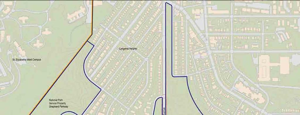
8 Site History St. Elizabeths West Campus 176 acres Established in 1852 Located in Southeast DC. Part of Ward 8 neighborhoods National Historic Landmark 1.1 million gross square feet of existing structures Proximate to the Capitol and White House 8
9 Project History 2004 Site transferred to GSA from Department of Health and Human Services 2005 GSA began preparing a master plan for the redevelopment of the site Coast Guard identified as first tenant 2006 DHS headquarters, including Coast Guard, identified as entire site tenant 9

10 DHS Need Employees scattered in about 70 buildings throughout National Capital Region. Current housing diminishes the agency s ability to perform its mission in an effective and efficient manner. Dispersion also adversely impacts critical communication, coordination and cooperating among DHS components. Consolidation will foster one-dhs culture 10
11 Purpose and Need for Action Purpose of the action: Development 4.5 million gross square feet (GSF) of office space plus 1.8 million GSF parking for a total of 6.3 million GSF to accommodate consolidated DHS Need for action: Support DHS collocation requirement 11


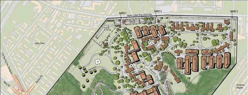
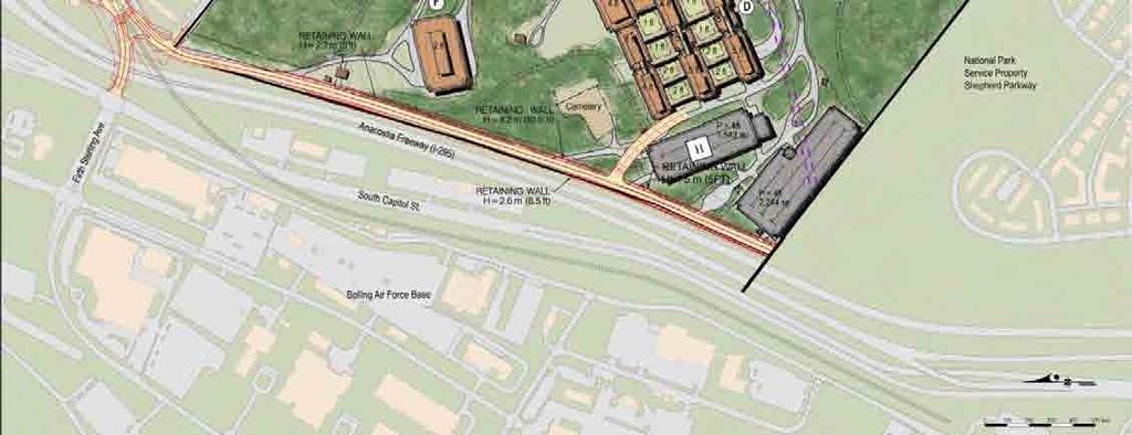
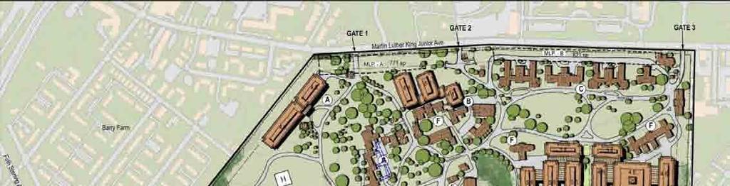
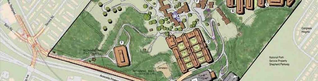
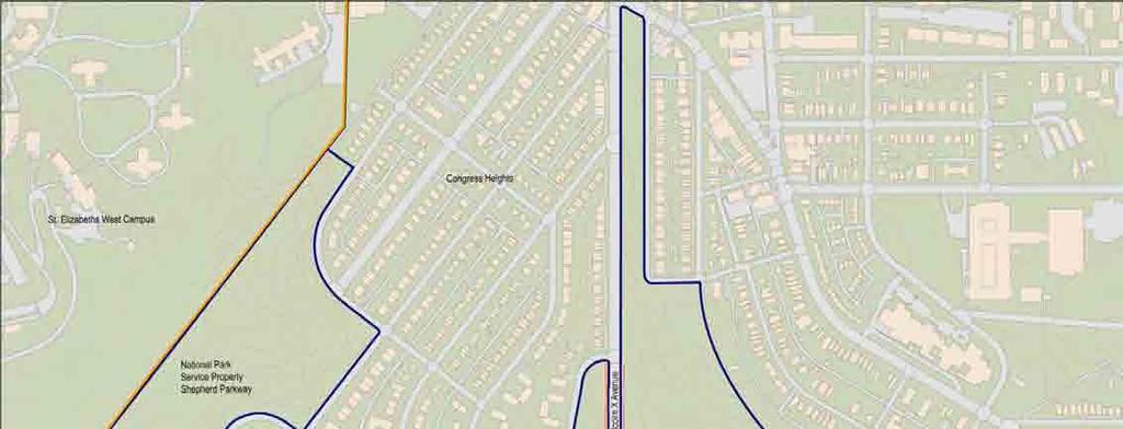
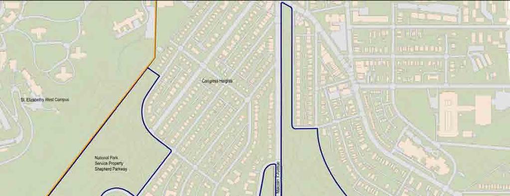
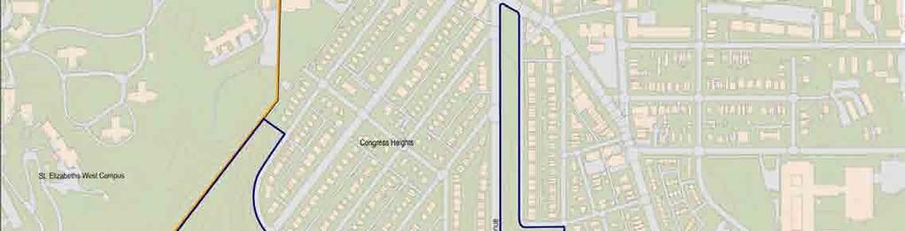
12 St. Elizabeths West Campus Greenhouse Gate 1 Martin Luther King Jr. Ave Gate 2 Lettered Bldgs. Gate 3 Barry Farm The Point Pavilion Center Building Ravine Warehouse Congress Heights I-295 Shepherd Parkway 12


13 No Action Alternative DHS Headquarters would not be consolidated DHS inefficiencies would continue St. Elizabeths West Campus would not be redeveloped Buildings would be mothballed with minimal maintenance GSA would study retaining or disposing of property 13
14 Redevelopment Goals Achieve the maximum build-out of the site for federal use, while maintaining the historic character of the West Campus Provide a world-class federal workplace planned and designed by the nation s leading architects Use federal development in ways that consider community development goals and efforts Satisfy federal security requirements in a manner that remains sensitive to neighboring communities 14
15 Redevelopment Goals Provide facilities that meet the programmatic needs of the U.S. Coast Guard and the DHS Preserve, to a practicable extent, the natural context of the site Promote sustainable development by achieving a Silver Leadership in Energy and Environmental Design (LEED) rating Facilitate an open and inclusive process Improve transportation access to the campus Optimize the federal investment 15
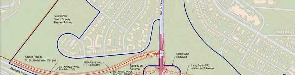
16 Redevelopment Alternatives 4.5 million gross square feet of office, operations, and shared-use space New and existing buildings 14,000 DHS employees 1.8 million gross square feet of parking 1 parking space for every 3 employees New access road between Firth Sterling Ave to Malcolm X Ave 16
17 Site and Program Parameter 100 foot security setback Parking at the perimeter of the site; no parking under buildings 30% vehicles from Martin Luther King, Jr. Avenue 70% vehicles from new access road between Firth Sterling and Malcolm X 17
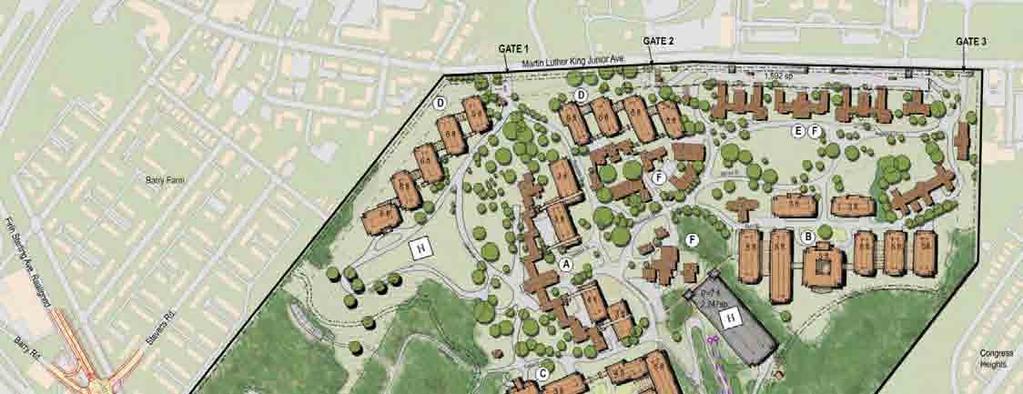
18 Alternative 1 18
19 Alternative 2 19
20 Alternative 3 20
21 Alternative 4 21

22 Impacts All development alternatives would impact Cultural resources Natural environment Social and economic environment Air quality Noise Utilities Environmental contamination Traffic 22
23 Historic Buildings Alternative 1 Alternative 2 Alternative 3 Alternative 4 Total Contributing Buildings Demolished 30 (48%) 29 (47%) 25 (40%) 18 (29%) Total Contributing Buildings Sq Ft Demolished 206,925 (23%) 199,256 (22%) 165,240 (18%) 100,306 (11%) Total Contributing Buildings Retained 32 (52%) 33 (53%) 37 (60%) 44 (71%) Total Contributing Buildings Sq Ft Retained 705,822 (77%) 713,491 (78%) 747,507 (82%) 812,441 (89%) 23
24 Cultural Landscape Alternative 1 Alternative 2 Alternative 3 Alternative 4 Total Landscape Features Total Adversely Affected Features Total Features Not Affected


25 Views St. Elizabeths Hospital location chosen for therapeutic views of rivers and downtown Views would be affected by new buildings Affected views include: To and from Center Building From south lawn From Congress Heights From West Campus Cemetery To the Shepherd Parkway 25
26 Archeological Resources Foundation of Hospital Gardener s House Foundation of Oakes Building Area between Martin Luther King, Jr. Avenue and Buildings #72 and #75 26


27 Natural Resources Geology, topography, and soils Surface waters Wetlands Vegetation and wildlife Protected species 27
28 Water Resources Existing Stream Length (Linear Feet) Stream Impacts (Linear Feet) Alternative 1 Alternative 2 Alternative 3 Alternative 4 2, ,070 1,092 Existing Wetlands (Acreage) Alternative 1 Wetland Impacts (Acreage) Alternative 2 Alternative 3 Alternative Shepherd Parkway Wetland Impacts 4,200 square feet 28
29 Vegetation Cover Type Herbaceous Rangeland Shrub and Brush Rangeland Acres Existing Alternative 1 Alternative 2 Alternative 3 Alternative Deciduous Forested Malcolm X/I-295 Interchange Impacts Alternative I-1 Alternative I-2 Alternative I-3 Alternative I-4 Deciduous Forested

30 Wildlife Minor loss of habitat Larger species may relocate to adjacent lands Smaller species would move within site during construction Temporary noise impacts during construction 30

31 Protected Species No species protected under the Endangered Species Act on or adjacent to the West Campus Bald Eagle nest located near the campus Protected under Bald and Golden Eagle Protection Act and Migratory Bird Treaty Act GSA is complying with the National Bald Eagle Management Guidelines 31


32 Social & Economic Resources Land Use Planning Population and Housing Economy, Employment and Income Community Facilities and Services Safety and Security 32
33 Land Use Planning Comprehensive Plan for the National Capital Two Elements: Federal Elements District Elements 33
34 Land Use Planning No Action Alternative inconsistent with plans Redevelopment alternatives are consistent with plans Reuse existing resources Locate federal employees near mass transit and central business area Facilitate economic growth Include parking ratio of 1 space for 3 employees Impact open space and natural features Limit public access to campus Redevelopment alternatives are inconsistent with plans Reduce size of Shepherd Parkway Reuse and demolish historic buildings 34
35 Population & Housing 74 percent of land near West Campus is public Housing and property values may increase 35
36 Environmental Justice Executive Order 12898, Environmental Justice Low-income and minority populations are in local neighborhoods Redevelopment alternatives would not have adverse ecological or human health effects 36
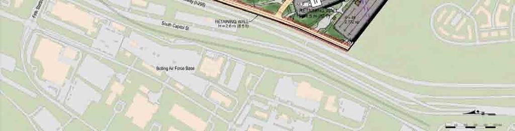
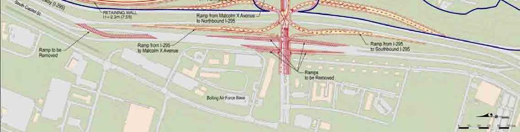
37 Economy & Employment Redevelopment of West Campus may create beneficial economic changes to Congress Heights Construction may generate employment opportunities for 26,655 in Metropolitan area Payroll earnings $931 million Total economic output $2.9 billion 37
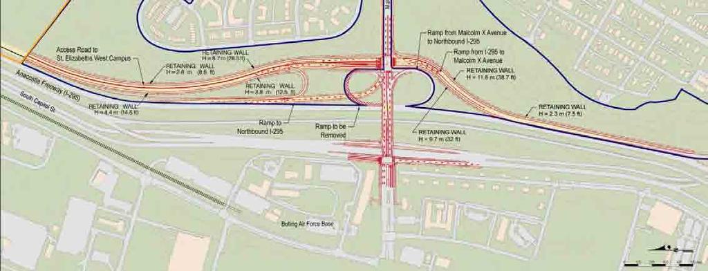
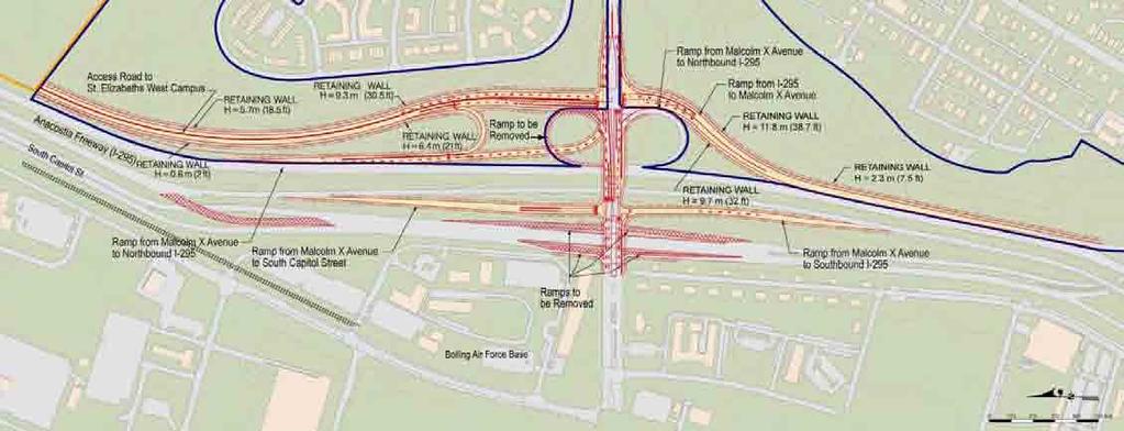
38 Community Facilities & Services Redevelopment alternatives would increase usage of: Public transportation Fire and Emergency Medical Services Police Services Community facilities such as libraries, education/childcare facilities, parks, and religious facilities 38
39 Safety & Security Security provided by Federal Protective Services Controlled access to Point during special events West Campus Cemetery outside security fence Security features designed to deter threats 39
40 Air Quality Redevelopment consistent with Clean Air Act Mobile sources, such as vehicles, would not exceed National Ambient Air Quality Standards Stationary sources, such as building equipment, would not exceed New Source Review limits Construction would create minor, short-term adverse impacts to air quality 40
41 Noise Noise levels modeled at 11 locations on and off-site Increases in noise levels would be imperceptible Construction would create minor, shortterm adverse impacts to noise levels 41
42 Utilities Installed from 1850s to 1990s and are in poor condition No stormwater management on-site All utilities would be replaced under redevelopment Solid waste would increase during construction and operation Stormwater management would be included in site design 42
43 Environmental Contamination Buildings contain asbestos, lead paint Fly ash used as insulation in at least one building Groundwater contamination has been remediated Fly ash on southern and western portion of site contains heavy metals and dioxin 43


44 Traffic 44 So. Capitol St. Malcolm X I-295 Firth Firth Sterling Sterling Martin Luther King Suitland Parkway Suitland Parkway
45 Malcolm X/I-295 Interchange To be reconstructed to allow for access to the West Campus from Malcolm X Reconstruction would be undertaken by FHWA and DDOT Four alternatives considered in Draft EIS 45
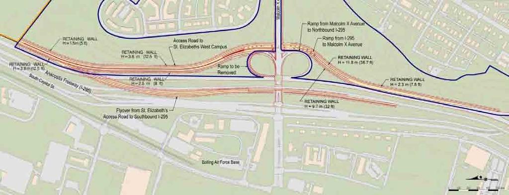
46 Alternative I-1 46
47 Alternative I-2 47
48 Alternative I-3 48
49 Alternative I-4 49
50 Traffic Planned Development Anacostia Gateway Salvation Army East of the River Corps Bolling Air Force Barry Farm redevelopment St. Elizabeths East Campus redevelopment 50
51 Traffic Planned Transportation Projects Suitland Parkway/MLK Avenue Interchange South Capital Street Bridge Reconstruction 11 th Street Bridges I-295/Suitland Parkway Interchange Anacostia Streetcar 51
52 Traffic Level of Service measured as A through F 19 intersections studied Only the Malcolm X/I-295 interchange ramps currently operates at LOS F in AM 52
53 Traffic No Action Levels of Service: Malcolm X/I-295 interchange would continue to fail in AM By 2013, Firth Sterling Avenue/Suitland Parkway and Suitland Parkway/South Capital Street would fail in PM By 2015, I-295 SB/Suitland Parkway would fail in PM 53
54 Traffic Redevelopment Alternatives GSA has proposed to reduce impacts to traffic through mitigation measures, such as turn lanes on MLK Reconstruction of Malcolm X/I-295 interchange would have beneficial impacts on traffic conditions Increased use of mass transit services All the West Campus Alternatives include sidewalks and bicycle access around and on the campus 54
55 Comments Public comment If you did not sign-up in advance of tonight to speak, please sign-up in the back of the room. When you come up front, speak and spell your name clearly into the microphone. Limit comments to three (3) minutes for individuals and five (5) for organizations. 55
56 Comments Written comments due by: November 13, 2007 May submit comments to: 56
57 Thank you
Transportation Improvements
 Transportation Improvements 0 0 Volume II of the Final EIS for the DHS Headquarters consolidation at St. Elizabeths includes analysis to transportation improvements for the DHS Headquarters Consolidation
2 Transportation Improvement Alternatives
 Transportation Improvement Alternatives Transportation Improvement Alternatives 5 6 7 8 9 0 5 6 7 8 9 0 5 6 This section documents the development of alternatives for transportation improvements in support
St Elizabeths Master Plan
 Department of Homeland Security Consolidated Headquarters at St. Elizabeths Washington, DC Presentation to CFA St Elizabeths Master Plan November 20, 2008 Preserving The Legacy / Realizing Potential 1
January 29, 2015 Page 1 of Annual Status Report St. Elizabeths Programmatic Agreement. PA Ref. Line Begin End. Description Timeframe Category
 2014 Annual Report Page 1 of 7 60 64 Finalize deed conveyance per Exchange Not Specified Recitals Completed. Agreement to Transfer Five Buildings and Related Land From DC to GSA 71 74 Finalize Occupancy
SUBJECT: PREDEVELOPMENT PLAN REVIEW OF PROJECT LOCATED AT 2632 EAST WASHINGTON BOULEVARD ('ST. LUKE MEDICAL CENTER')
") TO: FROM: Honorable Mayor and City Council Planning & Community Development Department SUBJECT: PREDEVELOPMENT PLAN REVIEW OF PROJECT LOCATED AT 2632 EAST WASHINGTON BOULEVARD ('ST. LUKE MEDICAL CENTER')
TO: FROM: Honorable Mayor and City Council Planning & Community Development Department SUBJECT: PREDEVELOPMENT PLAN REVIEW OF PROJECT LOCATED AT 2632 EAST WASHINGTON BOULEVARD ('ST. LUKE MEDICAL CENTER')
vi. master plan amendment concept
 vi. master plan amendment concept vi. master plan AMENDMENT concept Overview of the Planning Process The Master Plan for the Federal Use Parcel of the East Campus of St. Elizabeths is an Amendment to
Chapter 22. Alternatives to the Proposed Project
 Page 22-1 Chapter 22. Alternatives to the Proposed Project Introduction This chapter assesses the potential environmental effects of alternatives to the Proposed Project. The alternatives analyzed include
SUMMARY. Support the Southeast Arkansas Regional Intermodal Facility.
 SUMMARY THE I-69 LOCATION STUDY The proposed I-69 Location Study from El Dorado to McGehee, Arkansas, represents one section (Section of Independent Utility No. 13) of the nationally designated I-69 Corridor
2013 Annual Status Report St. Elizabeths Programmatic Agreement. January 29, 2014 Page 1 of 8. PA Ref. Line Begin End. Description Timeframe Category
 Page 1 of 8 60 64 Finalize deed conveyance per Exchange Recitals Completed. Agreement to Transfer Five Buildings and Related Land From DC to GSA 71 74 Finalize Occupancy Agreements Recitals Completed.
East River Waterfront Esplanade and Piers New York, New York Draft Environmental Impact Statement
 East River Waterfront Esplanade and Piers New York, New York Draft Environmental Impact Statement October 12, 2006 CEQR No.: TO COME ULURP Nos.: TO COME Lead Agency: Lower Manhattan Development Corporation
WELCOME! 8 8:30 6: TH STREET IMPROVEMENTS. Open House. Presentation & Q&A
 WELCOME! 168 TH STREET IMPROVEMENTS 6:30 Open House 7 8 Presentation & Q&A 8 8:30 Open House WELCOME Todd Pfitzer City of Omaha Engineer Bob Stubbe City of Omaha Public Works Director Jon Meyer Project
Meeting Display Boards for Public Hearing on the Wilson Transfer Station Project held Tuesday, February 18, 2014.
 Meeting Display Boards for Public Hearing on the Wilson Transfer Station Project held Tuesday, February 18, 2014. Board 1: Welcome Welcome to the Wilson Transfer Station Project Public Hearing. The purpose
B. DESCRIPTION OF THE PROPOSED ACTION
 Executive Summary A. INTRODUCTION Metro-North Commuter Railroad Company ( Metro-North or the Project Sponsor ) is proposing the construction of a new, expanded parking garage at 50 Haarlem Avenue (formerly
V. PLANNING PRINCIPLES And
 V. PLANNING PRINCIPLES And Urban Design Framework V. Planning Principles And Urban Design Framework Overview The responds to the planning parameters and the development potential framework established
LITTLE ITALY UNIVERSITY CIRCLE (MAYFIELD STATION) COMMUNITY MEETING FEBRUARY 21, 2013
 COMMUNITY MEETING FEBRUARY 21, 2013") LITTLE ITALY UNIVERSITY CIRCLE (MAYFIELD STATION) COMMUNITY MEETING FEBRUARY 21, 2013 Environmental Assessment (EA) Availability Completed in Compliance with the National Environmental Policy Act (NEPA)
LITTLE ITALY UNIVERSITY CIRCLE (MAYFIELD STATION) COMMUNITY MEETING FEBRUARY 21, 2013 Environmental Assessment (EA) Availability Completed in Compliance with the National Environmental Policy Act (NEPA)
Asbury Chapel Subdivision Sketch Plan
 Asbury Chapel Subdivision Sketch Plan PART 1: PROJECT SUMMARY Applicant: NVR Inc. Project Size: +/- 76.13 acres Parcel Numbers: 02101112,02116101,02116112, 02116113 Current Zoning: Transitional Residential
PARTNERSHIP FOR COLLABORATIVE INNOVATION
 RESPONDENT TEAM: PARTNERSHIP FOR COLLABORATIVE INNOVATION THORON CAPITAL Phase I redevelopment PRESENTATIONS Saint Elizabeths east campus September 30, 2014 The Team Roles and Responsibilities MASTER DEVELOPER
St. Elizabeths East - 5 Year Anticipated Use Plan
 Agenda 1. Introductions 2. St Elizabeths East Overview 3. Stage One Infrastructure Improvements 1. Role of the D.C. Department of General Services and D.C. Department of Transportation 2. DC Water Tower
Planning & Zoning Commission Staff Report
 Planning & Zoning Commission Staff Report Meeting Date: May 26, 2015 Drafted by: Katherine Harrison-Rogers CASE # Z2886 PROJECT NAME: APPLICANT/ REPRESENTATIVE: Shawna Runyan PROPERTY OWNER: 1840 (previously
Ann Arbor Intermodal Station Environmental Review
 Ann Arbor Intermodal Station Environmental Review Park Advisory Commission September 19, 2017 AGENDA 1. Project Update 2. Draft Environmental Assessment 3. Draft Preferred Alternative 4. Next Steps 5.
APPENDIX D: Visual and Aesthetic Conditions for NCCU Station Refinement. Durham-Orange Light Rail Transit Project
 APPENDIX D: Visual and Aesthetic Conditions for NCCU Station Refinement Durham-Orange Light Rail Transit Project October 2016 1. Introduction The Combined FEIS/ROD summarizes the effects of the D-O LRT
V. PLANNING PRINCIPLES And
 V. PLANNING PRINCIPLES And Urban Design Framewo rk V. PLANNING PRINCIPLES AND URBAN DESIGN FRAMEWORK Gate 1 Gate 2 Overview The St. Elizabeths West Campus Master Plan responds to the planning parameters,
Open House Public Involvement Meeting Howland High School Cafeteria, 200 Shaffer Drive NE, Warren, Ohio. Informational Handout
 Open House Public Involvement Meeting Howland High School Cafeteria, 200 Shaffer Drive NE, Warren, Ohio SR 46 (Niles Cortland Road) and SR 82 Proposed Improvements Howland Township, Trumbull County, Ohio
Draft Evaluation of Alignment Alternatives Methodology and Results Report. 3 nd Draft. May 2011(rev June 17, 2011)
") Draft Evaluation of Alignment Alternatives Methodology and Results Report 3 nd Draft May 2011(rev June 17, 2011) Draft Evaluation of Alignment Alternatives Methodology and Results Report Table of Contents
Draft Evaluation of Alignment Alternatives Methodology and Results Report 3 nd Draft May 2011(rev June 17, 2011) Draft Evaluation of Alignment Alternatives Methodology and Results Report Table of Contents
WEST OAKLAND SPECIFIC PLAN & DRAFT ENVIRONMENTAL IMPACT REPORT
 WEST OAKLAND SPECIFIC PLAN & DRAFT ENVIRONMENTAL IMPACT REPORT Landmarks Preservation Advisory Board Public Hearing February 10, 2014 1 Specific Plan Overview Plan Area is generally bounded by I-580 to
Goal 1 To establish and follow land use patterns for the long-range development of the campus.
 ELEMENT 4 FUTURE LAND USE Goal 1 To establish and follow land use patterns for the long-range development of the campus. Objective 1A Correct existing incompatible campus land uses. Policy 1A-1 Reduce
Goal 1: To Encourage the Orderly, Harmonious and Judicious Use of University Resources in the Development of University Land.
 2.0 Future Land Use Goal 1: To Encourage the Orderly, Harmonious and Judicious Use of University Resources in the Development of University Land. Objective 1.1: Make available future building sites that
Overview of Southwestern Pennsylvania Commission s (SPC) 2040 Long Range Transportation Plan (LRTP)
 2040 Long Range Transportation Plan (LRTP)") Overview of Southwestern Pennsylvania Commission s (SPC) 2040 Long Range Transportation Plan (LRTP) Presented to Pennsylvania Agency Coordination Meeting May 27, 2015 Doug Smith & Ryan Gordon 1 Southwestern
Overview of Southwestern Pennsylvania Commission s (SPC) 2040 Long Range Transportation Plan (LRTP) Presented to Pennsylvania Agency Coordination Meeting May 27, 2015 Doug Smith & Ryan Gordon 1 Southwestern
PROJECT BACKGROUND. Preliminary Design Scope and Tasks
 PROJECT BACKGROUND Preliminary Design Scope and Tasks The purpose of this Study is the development of preliminary designs for intersection improvements for Trunk Highway (TH) 36 at the intersections of
Project Overview. Get Involved. Public Information Meeting. Contact Information
 Get Involved VDOT representatives will review and evaluate information received as a result of this meeting. Please fill out the comment sheet provided in this brochure if you have any comments or questions.
Welcome. South Seminole Heights Civic Association, Inc. Tampa Interstate Study Supplemental Environmental Impact Statement.
 Welcome South Seminole Heights Civic Association, Inc. October 17, 2018 Tampa Interstate Study Supplemental Environmental Impact Statement 1 Stephen Benson Opening FDOT District Seven 2 3 Our solutions
University of the District of Columbia Van Ness Campus Master Plan Community Open House 3. December 8, 2010
 University of the District of Columbia Van Ness Campus Master Plan Open House 3 December 8, 2010 Introductions Sequence of Work: Campus Master Plan BEGIN: INTRODUCE AND START WORK Project Initiation Team
Ashland BRT Environmental Assessment: logos of CTA, CDOT, Chicago Department of Housing and Economic Development
 Ashland BRT Environmental Assessment: logos of CTA, CDOT, Chicago Department of Housing and Economic Development Overview The Chicago Transit Authority (CTA), in partnership with the Chicago Department
City of Meriden Harbor Brook Flood Control Project Overview
 City of Meriden Harbor Brook Flood Control Project Overview Updated August 2013 OVERVIEW The center of Meriden, including the HUB site is the low point of the town which is ringed by basalt ridges. Running
COMMUNITY DESIGN. GOAL: Create livable and attractive communities. Intent
 COMMUNITY DESIGN Intent An attractive, well-designed County will attract quality development, instill civic pride, improve the visual character of the community, and create a strong, positive image for
DRAFT SECTION 4(f) EVALUATION INTERSTATE 73 FEIS: I-95 to I-73/I-74 in North Carolina
 EVALUATION INTERSTATE 73 FEIS: I-95 to I-73/I-74 in North Carolina") DRAFT SECTION 4(f) EVALUATION INTERSTATE 73 FEIS: I-95 to I-73/I-74 in North Carolina 1.0 INTRODUCTION Section 4(f) of the Department of Transportation Act of 1966, 49 U.S.C. 303, requires that prior to
DRAFT SECTION 4(f) EVALUATION INTERSTATE 73 FEIS: I-95 to I-73/I-74 in North Carolina 1.0 INTRODUCTION Section 4(f) of the Department of Transportation Act of 1966, 49 U.S.C. 303, requires that prior to
OVERVIEW OF PLANS FOR THE JEFFERSON COUNTY COUNTRYSIDE FARM In the Context of Quality Place Characteristics
 OVERVIEW OF PLANS FOR THE JEFFERSON COUNTY COUNTRYSIDE FARM In the Context of Quality Place Characteristics By Steve Grabow, Professor and Community Development Educator University of Wisconsin-Extension,
City of Los Angeles Department of Public Works
 City of Los Angeles Department of Public Works Environmental Scoping Meeting for the Proposed Sixth Street Park, Arts, River & Connectivity Improvements (PARC) Project May 3, 2017 1 Agenda Introductions
Chesapeake Bay Critical Area Conservation Plan
 The Maryland-National Capital Park and Planning Commission Prince George s County Planning Department Development Review Division 301-952-3530 Note: Staff reports can be accessed at www.mncppc.org/pgco/planning/plan.htm.
DOMINION BOULEVARD CORRIDOR STUDY AND ECONOMIC DEVELOPMENT STRATEGIC PLAN A MODEL FOR CHESAPEAKE S FUTURE
 DOMINION BOULEVARD CORRIDOR STUDY AND ECONOMIC DEVELOPMENT STRATEGIC PLAN A MODEL FOR CHESAPEAKE S FUTURE Overview I. Draft Plan Process II. Draft Plan Overview a. Market Analysis b. Master Land Use Plan
PROJECT STATEMENT LOCATION/DESIGN PUBLIC HEARING. 19 th AVENUE NORTH EXTENSION PROJECT FROM SPRINGDALE DRIVE TO NORTH 2 ND STREET/U.S.
 PROJECT STATEMENT LOCATION/DESIGN PUBLIC HEARING 19 th AVENUE NORTH EXTENSION PROJECT FROM SPRINGDALE DRIVE TO NORTH 2 ND STREET/U.S. 67 HEARING LOCATION: ERICKSEN COMMUNITY CENTER 1401 11 TH AVENUE NORTH
California Environmental Quality Act (CEQA) Environmental Review Process
 Environmental Review Process") California Environmental Quality Act (CEQA) Environmental Review Process Los Angeles Union Station Forecourt and Esplanade Improvements constitute a Project Los Angeles County Metropolitan Transportation
California Environmental Quality Act (CEQA) Environmental Review Process Los Angeles Union Station Forecourt and Esplanade Improvements constitute a Project Los Angeles County Metropolitan Transportation
PUBLIC HEARING. Thursday, December 14, 2017 FDOT Urban Office 2198 Edison Avenue Jacksonville, FL 32204
 DISTRICT TWO PUBLIC HEARING I 10 (SR 8) from I 295 to I 95 Project Development & Environment Study Duval County, Florida Financial Project Number 213326 2 22 01 Efficient Transportation Decision Making
Site Alternatives and Phasing
 Site Alternatives and Phasing Site Alternatives - New Library Site (preferred) Introduction The UW Tacoma Library Needs Assessment shows that the library will require approximately 80,000-100,000 gross
Town of Liberty, NY COMPREHENSIVE PLAN & ZONING UPDATES
 Town of Liberty, NY S Public Informational Meeting October 4, 2016 High School Auditorium Welcome Thank you for coming tonight. Agenda Part I Overview of Proposed Changes What is Being Prepared Anticipated
r.i.s.e demonstration center
 r.i.s.e demonstration center washington, dc r.i.s.e. demonstration center site context R.I.S.E. Demonstration Center is the adaptive reuse of the historic St. Elizabeths East Chapel to create an interim
Southeast Extension to RidgeGate Parkway Scoping Booklet
 Southeast Extension to RidgeGate Parkway Scoping Booklet PUBLIC SCOPING MEETING SCHEDULE Public Scoping Meeting Wednesday, November 2, 2011 6:00pm to 7:30pm City of Lone Tree Recreation Center Willow Room
Portage Parkway Environmental Assessment Public Information Centre No. 1
 City of Vaughan Portage Parkway Environmental Assessment Public Information Centre No. 1 November 25, 2015 Welcome to the Public Information Centre This first Public Information Centre (PIC) introduces
Bus Rapid Transit Environmental Assessment and Section 4(f) Evaluation Summary
 Evaluation Summary") Bus Rapid Transit Environmental Assessment and Section 4(f) Evaluation Summary S.0 SUMMARY August 25, 2000 As a grantee of the Federal Transit Administration (FTA), the Greater Cleveland Regional Transit
Bus Rapid Transit Environmental Assessment and Section 4(f) Evaluation Summary S.0 SUMMARY August 25, 2000 As a grantee of the Federal Transit Administration (FTA), the Greater Cleveland Regional Transit
Subject: Hendry County Evaluation and Appraisal Report Letter of Understanding - Identification of Major Issues
 HENDRY COUNTY PLANNING & ZONING DEPARTMENT POST OFFICE BOX 2340 165 S. LEE STREET LABELLE, FLORIDA 33975 (863) 675-5240 FAX: (863) 675-5317 SUNCOM 744-4750 November 16, 2007 Mr. Mike McDaniel, Chief Office
124 Subarea Visions. Vision Plan. A. Nelessen Associates, INC I Visioning I Planning I Urban Design
 Subareas 124 Subarea Visions The next seven sections describe specific recommendations tailored to each subarea. Each subarea is discussed separately except for certain aspects of 95th Street and Antioch
Knoxville Area Transit (KAT) Transit Development Plan Corridor Analysis
 Transit Development Plan Corridor Analysis") Knoxville Area Transit (KAT) Transit Development Plan Submitted to: Knoxville-Knox County Metropolitan Planning Commission Submitted by: PB Americas, Inc. Under contract to: The Corradino Group, Inc. October
Knoxville Area Transit (KAT) Transit Development Plan Submitted to: Knoxville-Knox County Metropolitan Planning Commission Submitted by: PB Americas, Inc. Under contract to: The Corradino Group, Inc. October
Access to the University of North Carolina at Chapel Hill, UNC Hospitals, and Chapel Hill Transit.
 M 1/ 4 1/ 2 E IL M E IL Station Family: County: City: UNC Hospitals WHY THIS STATION? University Village Orange Chapel Hill Access to the University of North Carolina at Chapel Hill, UNC Hospitals, and
ALIGNMENT SEGMENTS & OPERATIONALLY INDEPENDENT SECTIONS
 ALIGNMENT SEGMENTS & OPERATIONALLY INDEPENDENT SECTIONS During the Draft SEIS it was anticipated that the Preferred Alternative would be constructed in stages or operationally independent sections (OIS).
Public Information Centre #1
 and Highway 401 Interchange Improvements WELCOME Public Information Centre #1 Veterans Memorial Parkway Extension and Highway 401 Interchange Improvements Study May 23, 2012 4 p.m. to 7 p.m. Brief Overview
The Atlanta BeltLine. Quarterly Briefing March @atlantabeltline. Reynoldstown Senior Affordable Housing
 The Atlanta BeltLine Quarterly Briefing March 30, 2017 @atlantabeltline @atlantabeltline @atlantabeltline Reynoldstown Senior Affordable Housing Framework for a multi-use and transit corridor in the heart
3.8 CUMULATIVE IMPACTS
 TIER II DRAFT ENVIRONMENTAL IMPACT STATEMENT 3.8 CUMULATIVE IMPACTS 3.8.1 What are the results of the Cumulative Impacts analysis? The No Action Alternative along with the four action alternatives were
Planned Development Review Revisions (Project No. PLNPCM )
") Planned Development Review Revisions (Project No. PLNPCM2014-00139) Standard residential development Planned Development Example: Smaller lot sizes than what is allowed to create open space amenity. What
Planned Development Review Revisions (Project No. PLNPCM2014-00139) Standard residential development Planned Development Example: Smaller lot sizes than what is allowed to create open space amenity. What
UCONN Athletic District Improvements Scoping Meeting
 UCONN Athletic District Improvements Scoping Meeting Paul Ferri, Environmental Compliance Professional, UCONN Scott Bighinatti, Lead Environmental Scientist, Milone & MacBroom, Inc. CEPA Scoping Meeting
THE GEORGE WASHINGTON UNIVERSITY MOUNT VERNON CAMPUS
 THE GEORGE WASHINGTON UNIVERSITY MOUNT VERNON CAMPUS CAMPUS PLAN AMENDMENT AND FURTHER PROCESSING APPLICATION: PRE-HEARING SUBMISSION PELHAM REPLACEMENT PROJECT FILED WITH THE ZONING COMMISSION OF THE
Transportation. Strategies for Action
 Transportation A major priority for the Overlake Neighborhood is to develop a multimodal transportation system. To achieve this system, a balance has to be found among travel, circulation and access needs;
Clay Street Bridge Replacement Project
 Clay Street Bridge Replacement Project Frequently Asked Questions (FAQs) No. 2 April 4, 2018 The project is located in downtown Placerville on Clay Street between US Highway 50 and Main Street and Cedar
Central Corridor Light Rail Transit. Environmental Assessment Three Infill Stations. Western, Victoria, and Hamline
 Central Corridor Light Rail Transit Environmental Assessment Three Infill Stations Western, Victoria, and Hamline Metropolitan Council January 2010 ABSTRACT The Metropolitan Council on behalf of the Federal
KING GEORGE COUNTY BOARD OF SUPERVISORS. Update on Governor Harry W. Nice Bridge Replacement Project February 6, 2018
 KING GEORGE COUNTY BOARD OF SUPERVISORS Update on Governor Harry W. Nice Bridge Replacement Project February 6, 2018 Tonight s Goals Project Design and Schedule Update Noise Analysis Results Determine
The Trinity River Corridor Project Update
 The Trinity River Corridor Project Update Councilmember Carolyn A. Davis Community Meeting October 14, 2008 The project covers 20 miles of the Trinity River, approx. 10,000 acres 2 Trinity River Corridor
Land Use Amendment in Southwood (Ward 11) at and Elbow Drive SW, LOC
 at and Elbow Drive SW, LOC") 2018 November 15 Page 1 of 10 EXECUTIVE SUMMARY This land use amendment application was submitted by Rick Balbi Architect on 2017 August 31 on behalf of Sable Developments Ltd, and with authorization from
2018 November 15 Page 1 of 10 EXECUTIVE SUMMARY This land use amendment application was submitted by Rick Balbi Architect on 2017 August 31 on behalf of Sable Developments Ltd, and with authorization from
St. Elizabeths Hospital/West Campus Landscape Character-Defining Features
 The following list of landscape character-defining features is taken directly from Chapter VII of the 2007 St. Elizabeths West Campus Cultural Landscape Report by Heritage Landscapes and Robinson & Associates,
PSRC REVIEW REPORT & CERTIFICATION RECOMMENDATION
 PSRC REVIEW REPORT & CERTIFICATION RECOMMENDATION KITSAP COUNTY COUNTYWIDE PLANNING POLICIES July 2, 2012 BACKGROUND A major emphasis of the Washington State Growth Management Act (GMA) is the need to
SOUTHWEST CORRIDOR EXTENSION. Environmental Evaluation and Basic Engineering Results PUBLIC MEETING/OPEN HOUSE November 18, 2009
 SOUTHWEST CORRIDOR EXTENSION Environmental Evaluation and Basic Engineering Results PUBLIC MEETING/OPEN HOUSE November 18, 2009 AGENDA I. Welcome/Introductions II. Project Review and Status III. Environmental
PIKE PINE RENAISSANCE: ACT ONE. October 19, 2017
 PIKE PINE RENAISSANCE: ACT ONE October 19, 2017 WATERFRONT SEATTLE PROGRAM PROJECT INTRODUCTION Pike and Pine streets, between First and Melrose avenues Pedestrian and streetscape improvements Budget:
Description of Preferred Alternative
 Chapter 2 Description of Preferred Alternative 2.1 Introduction This chapter of the programmatic Sammamish Town Center Sub-area Plan Final EIS provides a more detailed description of the Preferred Alternative
DRAFT MAP AMENDMENT FLU 04-4
 DRAFT MAP AMENDMENT FLU 04-4 SW 24 TH AVENUE ROADWAY CORRIDOR The University of Florida participates with the Metropolitan Transportation Planning Organization (MTPO) in its responsibilities for the continuing,
178 Carruthers Properties Inc.
 178 Carruthers Properties Inc. Planning Rationale for 178 Carruthers Avenue Site Plan Control Application June 2014 Table of Contents 1.0 Introduction 2.0 Overview of Subject Property 3.0 Current Zoning
Right-of-Way Acquisitions and Relocations Technical Memorandum
 Right-of-Way Acquisitions and Relocations Technical Memorandum Southeast Extension Project Lincoln Station to RidgeGate Parkway Prepared for: Federal Transit Administration Prepared by: Denver Regional
US-69 McAlester. Anthony Echelle, P.E. ODOT Division II Engineer
 US-69 McAlester US-69 from the US-270 junction south approximately 2 miles to Fourteenth Street, including the Village Road (Kinkead Road) interchange and adjacent frontage roads. Anthony Echelle, P.E.
NOTICE OF PREPARATION
 NOTICE OF PREPARATION DATE: January 6, 2016 TO: LEAD AGENCY: Responsible Agencies, Organizations, and Interested Parties Contact: Tyler Barrington, Principal Planner Planning Department Community Development
Gold Line Bus Rapid Transit Transit Oriented Development (BRTOD) Helmo Station Area Plan
 Helmo Station Area Plan") Appendix F Gold Line Bus Rapid Transit Transit Oriented Development (BRTOD) Helmo Station Area Plan Introduction and Purpose of the Plan The Gold Line Bus Rapid Transit facility is an eleven-mile dedicated
Appendix F Gold Line Bus Rapid Transit Transit Oriented Development (BRTOD) Helmo Station Area Plan Introduction and Purpose of the Plan The Gold Line Bus Rapid Transit facility is an eleven-mile dedicated
ALTERNATIVES. NCDOT made an early decision to first determine how to build the project (construction method) followed by what to build (alternatives).
 followed by what to build (alternatives).") III. ALTERNATIVES A. CONSTRUCTION METHOD ALTERNATIVES NCDOT made an early decision to first determine how to build the project (construction method) followed by what to build (alternatives). One of the
III. ALTERNATIVES A. CONSTRUCTION METHOD ALTERNATIVES NCDOT made an early decision to first determine how to build the project (construction method) followed by what to build (alternatives). One of the
I-70/71 Innerbelt Project
 I-70/71 Innerbelt Project Project Progress Meeting and Design Enhancement Update November 9, 2009 Ohio Department of Transportation MS Consultants MSI Design Overview of Presentation 1. Recap Recent Project
Welcome to the Oakridge Centre Open House
 Welcome to the Oakridge Centre Open House Why is the City hosting this event? This open house is to inform you of a rezoning application submitted to the City of Vancouver to amend the existing CD-1 (Comprehensive
Learning Objectives. Introduction. Design at an Ecodistrict Scale can Change Washington, DC s Landscape
 Learning Objectives Design at an Ecodistrict Scale can Change Washington, DC s Landscape Presenters Elizabeth Miller, ASLA, National Capital Planning Commission Diane Sullivan, National Capital Planning
Reclaiming Old West Broad Street: I-16 Ramp Removal Study
 Reclaiming Old West Broad Street: I-16 Ramp Removal Study Community Meeting Summary July 15, 2014 The first community meeting for Phase II of the I-16 Ramp Removal Study was held on July 15, 2014, at the
NORTH CLAYMONT AREA MASTER PLAN COMMUNITY WORKSHOP #1 FEBRUARY 3, 2016
 NORTH CLAYMONT AREA MASTER PLAN COMMUNITY WORKSHOP #1 FEBRUARY 3, 2016 1. Introduction To the team and to the Plan Planning Partners The Claymont Community WILMAPCO New Castle County Claymont Renaissance
MAYFIELD WEST SECONDARY PLAN PHASE 2
 MAYFIELD WEST SECONDARY PLAN PHASE 2 Public Open House #3 February 25, 2010 Draft Preferred Land Use Scenario TOWN OF CALEDON PLANNING & DEVELOPMENT DEPARTMENT Open House Agenda TOWN OF CALEDON 1. Welcome
FINAL MITIGATION PLAN to address
 CENTRAL CORRIDOR LRT STATE CAPITOL MALL HISTORIC FINAL MITIGATION PLAN February 2010 FINAL MITIGATION PLAN to address Adverse Effects of the Central Corridor LRT Project on the State Capitol Mall Historic
4. ENVIRONMENTAL IMPACT ANALYSIS 7. LAND USE AND PLANNING
 4. ENVIRONMENTAL IMPACT ANALYSIS 7. LAND USE AND PLANNING 4.7.1 INTRODUCTION The following analysis discusses the consistency of the Proposed Project with the corresponding land use and zoning designations
Rapid Transit Implementation Working Group
 Rapid Transit Implementation Working Group October 12, 2017 1 Agenda 1. Consultation Update 2. Technical Work Update 3. LTC Rapid Transit Integration 4. Next Steps 2 Consultation Update 3 Consultation
Secrest Short Cut and Monroe Expressway Small Area Plan AUGUST 29, 2018
 Secrest Short Cut and Monroe Expressway Small Area Plan AUGUST 29, 2018 Background and Process Monroe Expressway will be open by the end of 2018 Union County and Indian Trail identified a need to revisit
Atlanta BeltLine. Subareas 9 & 10. Master Plan Updates. March 26, Washington Park Jamboree 1
 Atlanta BeltLine Subareas 9 & 10 Master Plan Updates March 26, 2018 Washington Park Jamboree 1 22 miles, connecting 45 neighborhoods 22 MILES of transit 46 MILES of streetscapes and complete streets 33
Northern Branch Corridor SDEIS March Table of Contents
 Table of Contents Executive Summary... ES-1 ES.1 Introduction... ES-1 ES.2 Project Background... ES-1 ES.3 Purpose and Need... ES-5 ES.4 Alternatives... ES-6 ES.5 Operating Plan... ES-11 ES.6 Cost Analysis...
STATE UNIVERSITY CONSTRUCTION FUND Lead Agency, State Environmental Quality Review Act
 UNIVERSITY AT BUFFALO SCHOOL OF MEDICINE AND BIOMEDICAL SCIENCES SEQRA FINAL SCOPING DOCUMENT FOR THE Draft Environmental Impact Statement STATE UNIVERSITY CONSTRUCTION FUND Lead Agency, State Environmental
Senator Sieben SF Representative Schoen HF Presentation Guide
 Senator Sieben SF 1179 Representative Schoen HF 1374 Presentation Guide Appearance Transportation and Public Safety, Room 15 of the Capitol. 3-5:30 PM on Wednesday, March 13 Speakers Honorable Senator
AUTO CIRCULATION & PARKING
 CHAPTER 5 Chapter 5 Auto Circulation & Parking AUTO CIRCULATION & PARKING Parking use and automobile circulation have been topics of many discussions on street corners as well as at public workshops and
Atlanta BeltLine Corridor Environmental Study. Scoping Meeting August 2008
 Atlanta BeltLine Corridor Environmental Study Scoping Meeting August 2008 What Will We Be Discussing Today? Study Overview - How Did We Get Here? - What Is the Study About? - Who Is Involved? - Where Is
LAND USE AMENDMENT DOWNTOWN COMMERCIAL CORE (WARD 7) MACLEOD TRAIL SE AND 5 AVENUE SE BYLAW 254D2017
 MACLEOD TRAIL SE AND 5 AVENUE SE BYLAW 254D2017") Page 1 of 10 EXECUTIVE SUMMARY This Land Use Amendment application seeks to redesignate a full downtown block (currently the YWCA site) from a Direct Control based on the CM-2 District (Land Use Bylaw
Page 1 of 10 EXECUTIVE SUMMARY This Land Use Amendment application seeks to redesignate a full downtown block (currently the YWCA site) from a Direct Control based on the CM-2 District (Land Use Bylaw
Asheville Design Center March 2010
 Community-Based Design Update Asheville Design Center March 2010 www.ashevilledesigncenter.org 1 introduction contents 1. Introduction 2. Background 3. ovember Design Charrette 4. January Work Session
PURPOSE: The purpose is to provide commercial facilities in the Vancouver and Clark County vicinity.
 US Army Corps of Engineers Seattle District Joint Public Notice Application for a Department of the Army Permit and a Washington Department of Ecology Water Quality Certification and/or Coastal Zone Management
STATE OF TENNESSEE DEPARTMENT OF TRANSPORTATION ENVIRONMENTAL DIVISION
 STATE OF TENNESSEE DEPARTMENT OF TRANSPORTATION ENVIRONMENTAL DIVISION Suite 900 - James K. Polk Building 505 Deaderick Street Nashville, Tennessee 37243-0334 MEMORANDUM TO: FROM: Files Joe W. Matlock,
RIVER ARTS DISTRICT TRANSPORTATION PROJECT
 RIVER ARTS DISTRICT TRANSPORTATION PROJECT A section of the Public Meeting #3 December 6, 2012 The RiverWay Plan The Wilma Dykeman RiverWay is a 17 mile corridor along the French Broad and Swannanoa Rivers.
Blackfriars Bridge Municipal Class Environmental Assessment. Public Information Centre #1 November 19 th, 2014
 Blackfriars Bridge Municipal Class Environmental Assessment Public Information Centre #1 November 19 th, 2014 Why are you here tonight? To determine the future requirements of the river crossing at Blackfriars