White Hart Lane - Environmental Improvements
|
|
|
- Carol Porter
- 5 years ago
- Views:
Transcription


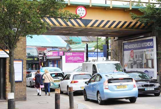
1 White Hart Lane - Environmental Improvements Today s event is one of a number of information sessions held in the area, to ensure that local people are informed about the projects planned for White Hart Lane and to give you the opportunity to comment on the proposal. The designs and plans presented reflect conversations that have taken place with local residents, community groups, businesses and land owners. About White Hart Lane White Hart Lane is a place where people live and work, a place where children grow up. White Hart Lane has a community of independent shop keepers and businessess and has a rich history. There is an invisible river beneath the pavement and there is the potential to be a much greener place. White Hart Lane is a strategic route; one of the few east west roads that can be used by high sided vehicles because of the low railway bridges on surrounding roads. However an over emphasis on the use of the road by cars has undermined the environmental quality of the neighbourhood for people walking, using public transport or cycling. In addition the junction with the High Road is an accident spot and the pavements throughout are narrow and are poorly designed for people with mobility issues. What we are trying to do The aim of this project is to make White Hart Lane more attractive and welcoming, to make it a better place to live, to support the existing shops and to encourage more businesses to come to the area. The illustrations on the following boards show early design principles for altering the junction, widening the pavements and traffic calming, sustainable drainage, greening the street and the proposed materials. Once we have the final survey information and have gathered feedback from you, the community, businesses and other partners we will finalise the design. North Tottentham is Changing The improvements to White Hart Lane are part of the much bigger plans for major investment and regeneration in the area that includes: The High Road West Development - the building of a sustainable neighbourhood to the north and south of White Hart Lane with over,000 new homes set around a new square, library and learning centre and existing workspace as part of new leisure hub. White Hart Lane Station - the 1m+ refurbishment will make the station safer and more accessible with a new entrance and improved access to platforms. Plans for the regeneration of Northumberland Park and Love Lane Estate combined with the new Tottenham Hotspur Football Club Stadium development will improve the health, wellbeing and prospects for local residents, including providing health centres and schools; create thousands of new jobs; and it will deliver high quality community facilities at the heart of the area.
2 White Hart Lane - Proposed Improvements Plan of White Hart Lane showing the proposed improvements from the junction with the High Road to Creighton Road roundabout a 4 a Creighton Road roundabout textured road surface level with pavement to slow vehicles Rain gardens throughout to filter the pollution washed off the road and stop flooding Wider pavements, the dashed red line shows the existing width of the pavement Permeable pavements throughout to let the rain soak through to help prevent flooding Permeable road surface on Penshurt Road and Love Lane to let the rain soak through to help prevent flooding Textured road surface raised to pavement level to slow traffic and make places for people to cross and to replace existing crossing a Boundary to Love Lane estate moved south to ensure the existing trees are protected as part of White Hart Lane Pavement continues over side street junctions to make crossings level with the pavement Junction at High Road remodelled to reduce accidents and improve crossing for pedestrian Width of road narrowed to enforce 0mph speed limit and keep traffic moving White Hart Lane station entrance as part of improvements delivered in a separate scheme Station forecourt as part of improvements delivered in a separate scheme Drop off and disabled parking for station West bound bus stop located further west East bound bus stop remains in the same location Extent of White Hart Lane improvements 11 High Road West masterplan indicative building footprint Exisitng shops and businesses

3 35 White Hart Lane - Environmental Improvements to Reduce the Impact of Traffic White Hart Lane now White Hart Lane is well served by public transport with the overground station and an extensive district network of bus routes that converge in the area. In addition, the Cycle Super Highway 1 is situated 800m south of the station, connected to the site via the local cycle network. However, although traffic numbers on White Hart Lane are relatively low outside peak hours, the road is a hostile environment for pedestrians, people accessing public transport and cyclists. Traffic regularly exceeds the 0mph speed limit and the road is congested due to the complicated interdependent traffic lights at the High Road junction. This results in an increased risk of collisions and high levels of pollution. In a Ward where many people don t own cars this disproportionately impacts the people who actually live here, as much of the traffic is passing through east to west. How Can White Hart Lane Become a Better Environment for People? The key aim is to accommodate the traffic but not to let it dominate. This will be achieved by two principle design moves: 1.Reduction of the width of the carriageway so cars have less room and pedestrians have more room.. Inclusion of features which the motorist has to negotiate in stages, so they pay attention to what is immediately in front of them and are less likely to speed. The carriageway width is reduced from 4800mm to 3400mm, the difference is shown in the drawings below, in addition a central pattern runs along the centre of the road giving the impression the road is narrower than it is. This width was agreed with Transport for London who run the buses, the emergency services, to ensure ambulances have room to pass, and Haringey 14%, the local access group. Reducing the carriageway will increase the width of the pavement all along White Hart Lane. At intervals along the road we will raise the road up to the same level as the pavement. In these sections the road is treated with a contrasting material. The combination of the ramp up and down and the visual patterning reduces the tendency to speed and keeps traffic within the 0mph limit. Existing road layout outside the Grange All dimensions and levels to be checked on site before commencing work. Any discrepancies shall be immediately notified to the architect in writing. Do not scale from this drawing, use figured dimensions only. If in doubt consult the architect Existing low pressure gas main 54 Ø Gas pipe Existing Medium pressure Gas main 355Ø PE pipe inside 00 Ø Cast Iron Walkway Carriageway Carriageway Footway Walkway Existing Sewer 375 Ø Assumed construction of existing Culverted river. 01 Existing Section Proposed road layout outside the Grange All dimensions and levels to be checked on All site dimensions and levels to be checked on site before commencing work. All before dimensions commencing and levels work. Any discrepancies shall be immediately notified to be checked on site before Any discrepancies commencing shall work. be immediately notified to the architect in writing. Any to the discrepancies architect in shall writing. be immediately notified Do not scale from this drawing, use figured to Do the not architect scale from in writing. this drawing, use figured dimensions only. Do dimensions not scale from only. this drawing, use figured If in doubt consult the architect. dimensions If in doubt consult only. the architect. If in doubt consult the architect. A REVISION For Information DESCRIPTION DATE ~ 1:70 ~ 1: ~ 1:70 ~ 1: ~ 1:70 ~ 1: :5 drawing title Typical Existing & Proposed Sections drawing no revision 1.3-L-114 / scale at A1 creation date 1: project number project name 1.3 White Hart Lane 01 Existing Section 01 Existing Section client Haringey Council Proposed Section Proposed road layout west of the Grange muf muf architecture/art LLP 7-74 Mare Street London E8 4RT T E studio@muf.co.uk W3 Tottenham W3 Tottenham W3 Tottenham A REVISION A For Information DESCRIPTION DATE For Information REVISION DESCRIPTION DATE A REVISION For Information DESCRIPTION DATE ~ 1:70 ~ 1: :70 ~ 1: ~ ~ 1:70 ~ 1: :5 1:5 1:5 drawing title drawing Typical title Existing & Proposed Sections Typical Existing & Proposed Sections drawing no revision drawing title drawing 1.3-L-114 no revision / Typical Existing & Proposed Sections 1.3-L-114 / scale at A1 creation date drawing no revision scale at A1 creation date 1: L-114 1:5 / project number project name scale at A1 creation date 1: project number project name project number project name 1.3 White Hart Lane 1.3 White Hart Lane client 1.3 White Hart Lane client Haringey Council Haringey Council Central patterned strip to give the impression the road is narrower than it is Raised table with a ramp up and down and a pattern surface to break of the linearity of the road Narrower carriageway results in wider pavements Pavement continues over side streets to make level crossings 0 Proposed Section 0 Proposed Section client Haringey Council muf architecture/art LLP 7-74 Mare Street London muf muf muf architecture/art LLP muf 7-74 architecture/art Mare StreetLLP 7-74 London Mare Street London E8 4RT E8 4RT T T E studio@muf.co.uk E studio@muf.co.uk muf E8 4RT T E studio@muf.co.uk


 as do levels of mono-nilimit trogen oxides (NOx).")
4 Improvements to the Junction with the High Road Currently the junction of White Hart Lane and the High Road is an accident hotspot because of the lane layouts. In addition the phasing of the traffic lights causes congestion along White Hart Lane. Existing Plan of Junction as it is today at White Hart Lane and High Road Proposed Plan for White Hart Lane and High Road Junction to help reduce the number of accidents. LOOK LEFT LOOK RIGHT LOOK LEFT Junction as it is Today White Hart Lane Collision Pollution Levels Study Area Study Area LOOK RIGHT Pedal Cycle Nitrogen Dioxide Levels on White Hart Lane are at above the EU permissible level of 40 µg/m3 Bus/coachor excldng minibus POLLUTION per metre cubed). Taxi (microgrammes Goods vehicles Pollution Levels STO AR P KEE CLE The junction of White Hart Lane and High Road has Nitrogen Dioxide Levelsthe on permissible White Hart Lane are at levels of NOX exceeding levels. Car or above the EU permissible level of 40 µg/m3 Powered Wheeler (microgrammes per metre cubed). P BUS 014 LOOK LEFT P Powered Wheeler Other LOOK LEFT POLLUTION T LOOK RIGH STO Car BUS Collision Locations 015 UNKNOWN G0.90 H1 Pedal Cycle S Particulate Matter PM 10 & PM.5 are below the The junction of White Hart Lane and High Road has permissible levels however any long term Bus/coachEU excldng minibus levels of NOX exceeding the permissible levels. Taxi exposure to PMs at any level is damaging to health. Goods Vehicles Other Harringey 013.xlsx Car Pedal cycle Particulate Matter PM 10 & PM.5 are below the EU permissible levels however any long term exposure to PMs at any level is damaging to health. Powered Wheeler Bus/coach excldng minibus The junction between White Hart lane and the High Road is the nd worst accident spot in the borough. Between , eight pedestrians have been injured, two classified as serious, four cyclists have been involved in collisions of which two are classified as serious EU Limit Levels of Nitrogen Dioxide exceed EU levels at 40 Ug/m3 EU (microgrammes per metre cubed) as do levels of mono-nilimit trogen oxides (NOx). The left turn lane from White Hart Lane is too narrow for turning vehicles The left hand turn lane into White Hart Lane is too narrow for turning vehicles Removal of the right turn lane from White Hart Lane to the High Road, to make a single wider lane will give more room for turning vehicles so they don t mount the pavement. Widening of the pavement on both sides of White Hart Lane at the High Road junction to give more space for pedestrians. The red dashed line shows the width of the existing pavement. Reducing three lanes to two will give the left turn lane from the High Road to White Hart Lane a wider lane for turning vehicles so they don t mount the pavement or pull out into the oncoming traffic lane. Traffic lights programmed to give pedestrians longer crossing times with larger islands in the centre of the road. Phasing will also reduce congestion of traffic heading east from White Hart Lane


, help slow stop storm water deliver the benefits of")


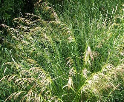


5 White Hart Lane - Environmental Improvements Greening the Street Greening White Hart Lane Preserving and Planting Trees We plan to increase the amount of planting on White Hart Lane, helping We will protect and improve conditions for the existing trees, for to mark the route of the Moselle. It will also act as an informal green link example by removing tarmac from around the base of the trunks. Our joining White Hart Lane to the Cemetery and Bruce Castle Park. ambition is to plant more trees, but this may be limited by the pipes under the pavement. There are already some mature trees of varying size trees on White Hart Lane and the Love Lane Estate and some smaller, younger trees by Trees will be planted in the rain gardens and we aim to plant the most the station. In areas with heavy traffic trees help reduce noise and the amount of dust and airborne grit pollution by between 7-4%. Trees also mature and therefore largest trees possible that the project budget will allow. While younger trees have a lower cost, it takes longer for them to Lobelia Ornamental grass have a cooling effect of up to C (3.F), help slow stop storm water deliver the benefits of more mature trees. runoff and absorb carbon. Creating Rain Gardens The mature trees were planted by the previous generation, they are an important link from the past to the future and are part of the character The rain gardens will be planted with low maintenance ornamental and heritage of the area. grasses and flowering perennial plants as well as shrubs and trees. The plants will be chosen to naturally thrive in conditions where they will be We plan to increase the amount of planting on White Hart Lane, helping occasionally flooded and can withstand pollution. to mark the route of the Moselle. It will also act as an informal green link joining White Hart Lane to the Cemetery and Bruce Castle Park. Tree species can include Birch, Cherry and Rowans. Ornamental grasses will cover the ground and deter weeds. There will also be sea- Dog Rose Ornamental grass sonal plants such as Dog Roses, Dogwood, Phlomis, Crocosmia and Lobelia. Ornamental grass Siberian Dog wood This is the existing state of the mature tree shown in the illustration above, it is trapped by the tarmac, the proposals is to remove the surrounding hard surfaces and give the tree roots room to breath and access to water Tottenham Cemetery Bruce Castle Park All Hallows Church yard Birch Black elder White Hart Lane Tottenham Cemetery Bruce Castle Park Much of the existing greenness of WHL is opportunistic and incidental, including the railway embankment, the yard in front of the Grange and even the greengrocers display The route to Tottenham Cemetery and Bruce Castle Park Cherry Rowan


6 White Hart Lane - Environmental Improvements Sustainable Urban Drainage Sustainable Urban Drainage Strategy What is Sustainable Urban Drainage (SuDS) SuDs is the practice of managing surface water by designing ground conditions to act like a sponge, holding water, filtering it and releasing slowly to rivers or the sewer to protect them from pollution and flooding. Since Victorian times rain has been seen as a problem rather than a vital resource that supports our city s green spaces and wildlife. Normally rainfall is directed as quickly as possible to drains. As we build more and more hard surfaces, during heavy or long storms the rain runoff to drains can overwhelm both the sewer system and rivers and cause flooding Rain garden to catch the water flowing off the road and act as a sponge to slow, cool and filter out We want to manage rainwater as close as possible to where it falls and help the rainwater soak though to the layers below. Paving slabs will be laid with small gaps between them. The gaps are filled with pollution-cleaning grit through which the water drains to the layers below which act as a sponge slowing the flow of the water into the Why should we have SuDS Rain garden layout on the south east side of White Hart Lane How are SuDS part of the WHL design Moselle. This helps improve the quality of the water that will eventually flow into the Moselle River. SuDS and Rain Gardens Although it is possible to have permeable roads using a special surface, it is very expensive. The proposed solution is to drain the rainwater What happens if we don t have SuDS running off the road surface into road side bioretention rain gardens. Directing rainwater to drains does not just cause flooding. Rain runoff The water runs into the rain gardens where it soaks through special from roads, pavements and roofs discharged into rivers causes soil, grit and gravel filtration layers to remove pollutants and is stored environmental damage in two ways. Firstly, runoff from urban areas in these layers before being released slowly to the Moselle. In smaller contains petrochemical and heavy metal pollutants that harm or destroy storms most water will be soaked up by the soil, soak into the ground wildlife in rivers. Secondly in warm weather, our roads and pavements below or be used by the plants in the rain gardens. Rain gardens are absorb heat from the sun and if it rains the rainwater is heated up. The planted with plants and trees that tolerate getting soaked from time to warm water that flows into rivers holds less oxygen which suffocates life time so rain gardens also make the streets look greener. A section through the WHL pavement and road showing how rain falls on the road is washed into the rain garden, the pollutants are filtered out and the cool and cleaner water then enters the Moselle culvert. in the river. the pollution before letting the run off into the Moselle culvert Natural rock along the edge of the rain garden marking the route of the Moselle River Permeable grit jointed paving, rain can pass through to soak into the layers of ground beneath. Fish in the Lea River killed by a summer downpour of pollution and depleted the oxygen. The Moselle River before it flows underground into White Hart Lane showing a fungus that lives on sewage. Water running off the road into a rain garde A section through the road, rain garden and pavement Another cause of environmental damage is through domestic pipe Will the SuDs on WHL entirely prevent flooding and pollution and why misconnections. Because our rainwater is hidden in pipes that doesn t everywhere have SuDS disappear underground, people frequently connect foul water pipes (toilets, sinks, dishwashers, etc) into the rainwater pipes. This means that instead of sewage flowing to a treatment plant it discharges directly into our rivers killing wildlife. A section through the pavement showing the granular build up that acts as a sponge New planning laws require that all new developments have SuDS. What is more difficult is fitting SuDS into roads that already exist. Rain gardens and permeable drainage need space underground for layers of grit to act as the sponge. This underground space is often full of pipes carrying water, gas, electricity and internet cables. These pipes have to SuDS and the Moselle be protected from the rainwater and from the roots of trees, so a rain The Moselle river is the watery heart of the proposed development area garden cannot be directly above where pipes are running under the and gives White Hart Lane its distinctive curves. The river now flows pavement. WHL has many, many pipes running along the street and the beneath the south side of the road but is visible just to the west as it SuDS has to work around these. We are using a radar survey to locate all flows through the cemetery and is obviously polluted with domestic the pipes to enable as much permeable surface as possible. effluent; detergents from dishwashers, washing machines and sewage from toilets. We want the sustainable drainage used in this project to be a benchmark in best practice for all future development. This project will also help raise awareness of the impact of misconnected pipes and start the process to fix this problem. Workmen covering over the Moselle to create a culvert in WHL at the end of the C19th Pipes under the pavement A typical rain garden during a down pour.


7 White Hart Lane - The Materials The proposed materials for White Hart Lane are durable and easy to replace. The street furniture and lighting design will be part of the next stage of design. 1. Permeable, grit jointed, artificial stone flag stone paving. Permeable, grit jointed, artificial stone block paving where cars overrun junctions 3. Granite kerbs to pavement and rain gardens 4. Natural stone on edges of rain gardens to mark the route of the Moselle River 5. White road markings or imprinted asphalt on the raised tables and centre line.. Asphalt William Street Example of a blended crossing where a side street meets the main road, the crossing is raised to remain at the same level as the pavement and is paved in a similar material. Example of a contrast in the colour and surface materials of the road with a central strip as a way to slow the traffic. Conventional road markings used in an unconventional way. A similar approach is proposed to visually break up the linear dominance of the road and so slow the traffic, especially on the crossings.
8 White Hart Lane - Environmental Improvements - What do you think? Would wider footpaths encourage you to walk more? Would increasing the number of crossings make it safer for you to cross the road? Would you feel comfortable crossing at a courtesy crossing, this is where the road is at level with the pavement and cars go up a ramp, like a speed bump, to slow them down? Would replacing the existing zebra crossing with more courtesy crossings be better or worse? Would a narrower road with slower moving traffic encourage you to cycle? What s your favourite idea of all the ideas we ve suggested? Do you feel that greenery, like that proposed, is important in a street? Would you like to see more schemes like this? What else should the designers be thinking about? What else are you thinking about in terms of the future of the street and the area? Please leave your comments on Post It Notes on this or other boards and/or talk to a member of the design team Next Steps The illustrations on these boards show early stage design principles for altering the junction, widening the pavements and traffic calming, sustainable drainage and greening the street and the material palette. Once we have more survey information about the location of underground pipes and have completed the engagement including your feedback we can finalise the design. Please leave your comments or talk to the project team members at the consultation or call or Lauren Schnieder or lauren. schnieder@haringey.gov.uk with any questions or comments.
9
Alma Road Rain Gardens, London
 Alma Road Rain Gardens, London SuDS used Rain gardens Permeable paving Tree planting Benefits 1. Location Reduction in flooding from intense rainfall. Reduced surface water pollution to receiving water
GREATER CAMBRIDGE CITY DEAL. Urban Design Guidance for Transport Infrastructure Projects
 GREATER CAMBRIDGE CITY DEAL Urban Design Guidance for Transport Infrastructure Projects KEY OBJECTIVES OF CITY DEAL The City Deal aims to help Greater Cambridge maintain and grow its status as a prosperous
BROWNFIELD REGENERATION LONDON
 P A V I N G CASE STUDY October 2015 Edition 2 Uniclass 572/1677 Public realm regeneration Iconic conservation area Shared surfaces Designing in detail BROWNFIELD REGENERATION www.paving.org.uk Introduction
Welcome to our public exhibition
 About Our Scheme Welcome to our public exhibition This exhibition gives you the chance to view and comment upon our emerging proposals for a new residential development of 68 new homes on the site of the
Public Consultation. Land at Monks Farm, North Grove. Welcome
 Welcome Welcome to our public exhibition for development on Land at Monks Farm, orth Grove. Gallagher Estates and Gleeson Strategic Land are preparing an outline planning application for new homes, open
Welcome to our public exhibition
 About our development Welcome to our public exhibition This exhibition gives you the chance to view and comment on our proposals for a new residential development of 165 high-quality homes, along with
Springhill Cohousing Development, Springfield Road, Stroud, Gloucestershire
 Springhill Cohousing Development, Springfield Road, Stroud, Gloucestershire SuDS used Swales Permeable paving Sub-base replacement geocellular storage Rill surface channel collection and conveyance Pond
Homeowners Guide to Stormwater BMP Maintenance
 Homeowners Guide to Stormwater BMP Maintenance What You Need to Know to Take Care of Your Property Rain Barrel Dry Well Rain Garden Pervious Asphalt Porous Pavers City of El Monte Stormwater BMP Management
Former North Works, Lickey Road, Longbridge, Birmingham
 Committee Date: 14/11/2013 Application Number: 2013/06431/PA Accepted: 27/08/2013 Application Type: Full Planning Target Date: 26/11/2013 Ward: Longbridge Former North Works, Lickey Road, Longbridge, Birmingham
Springhill Cohousing Development, Springfield Road, Stroud, Gloucestershire
 Springhill Cohousing Development, Springfield Road, Stroud, Gloucestershire Location: Springhill Cohousing Development, Springfield Road, Stroud, Gloucestershire Description: A dynamic SuDS scheme defines
water that enters our streams during storms. Any water the rain garden can t accept will continue into the storm sewer system.
 North Kensington Street and 32 nd Street North Green Street and Sewer Capacity Meeting Friday, July 20 and Monday, July 23, 2012 Summary of Citizen Questions and Concerns Thank you for participating in
Why we need the Counters Creek storm relief sewer
 Counters Creek storm relief sewer Why we need the Counters Creek storm relief sewer The problem The sewer network we operate today has been much improved and vastly extended over the years and remains
The Gwennap Parish Vision Statement
 QUICK GUIDE What is a Neighbourhood Development Plan? Ultimately it is a document used by developers or anyone wishing to submit a planning application that describes the vision, strategy, plans, regeneration,
PUTTING THE HEART INTO BATTERSEA. A vision
 PUTTING THE HEART INTO BATTERSEA A vision INTRODUCTION This document is a vision for creating a Battersea that its community can be proud of and it is about putting Battersea on the map. It is being proposed
Raingardens. Conserving and Protecting Water L
 L-5482 08-08 Raingardens Justin Mechell, Extension Assistant, and Bruce Lesikar, Extension Program Leader for Biological and Agricultural Engineering,The Texas A&M University System A raingarden is an
Welcome to our public exhibition
 About our scheme Welcome to our public exhibition Taylor Wimpey East Anglia intends to submit a detailed planning application for a new residential development of 39 high-quality homes at the B&M Concrete
HS2 Interchange Station Design
 Working on behalf of HS2 Interchange Station Design October 2018 www.hs2.org.uk 1 Interchange Station, Solihull Introduction In February 2018, HS2 Ltd appointed Arup to take forward the design of Interchange
Welcome to our public exhibition
 About our development Welcome to our public exhibition This public exhibition gives you the opportunity to view and comment on our proposals to create a new residential development on land adjacent to
Toronto Complete Streets Guidelines
 Toronto Complete Streets Guidelines 108 110 7.1 Green Infrastructure Design Principles 112 7.2 Context-Sensitive Green Streets 114 7.3 Key Green Street Elements Green infrastructure refers to natural and
Drainage. Alignment K:\D (D102241) SHERFORD\CONSOLIDATED PLANNING DOCUMENTS\MAIN STREET\SHERFORD MAIN STREET NARRATIVE REVISION
 SHERFORD\CONSOLIDATED PLANNING DOCUMENTS\MAIN STREET\SHERFORD MAIN STREET NARRATIVE REVISION") The Main Street therefore provides a key link for a HQPT bus system between the Park and Ride, through Sherford onto the A379 and Plymouth City Centre. There is no definitive description of an HQPT system,
The Main Street therefore provides a key link for a HQPT bus system between the Park and Ride, through Sherford onto the A379 and Plymouth City Centre. There is no definitive description of an HQPT system,
A VISION FOR ST DAVIDS. Agreed by the community at the SDRBA meeting on Monday 22 nd March 2004 at Exeter Community Centre
 A VISION FOR ST DAVIDS Agreed by the community at the SDRBA meeting on Monday 22 nd March 2004 at Exeter Community Centre This Vision Statement has been prepared after consultation with the residents,
Welcome. Site/11/04. Site/11/03. Proposed Site. 11,400 new homes needed in east Cambs
 Welcome Welcome to our consultation on our proposals for new homes on land north east of Soham Road, Fordham. Members of the project team are available to answer any questions you have and listen to feedback.
Priors Farm Estate SuDS Retrofitting Project, Cheltenham
 Priors Farm Estate SuDS Retrofitting Project, Cheltenham SuDS used Detention basins Bioretention Planters Rain Gardens Benefits Reduction of surface water flooding 1. Location Priors Farm Estate, Oakley,
LAND SECURITIES REDEVELOPMENT OF NEWNHAM COURT SHOPPING VILLAGE, MAIDSTONE
 LAND SECURITIES REDEVELOPMENT OF NEWNHAM COURT SHOPPING VILLAGE, MAIDSTONE Land at Environmental Statement: Non-Technical Summary Introduction Land Securities plc is applying to Maidstone Borough Council
Renfrew Close, London
 Renfrew Close, London SuDS used Rain gardens Shallow rainwater conveyance channel Shallow detention basin Conveyance channels Benefits 1. Location Effective reduction in flood risk. Creation of attractive,
Newcourt Masterplan. November Exeter Local Development Framework
 Newcourt Masterplan November 2010 Exeter Local Development Framework Background The Exeter Core Strategy Proposed Submission sets out the vision, objectives and strategy for the development of Exeter up
A detailed Access Guide to The Iron Bridge & Tollhouse
 A detailed Access Guide to The Iron Bridge & Tollhouse This Guide contains an overview of Access for: Visitors with physical and sensory disabilities Assistance Dogs are welcome at all Museum sites. www.ironbridge.org.uk
Meridian Water Phase 1 Application
 Meridian Water Phase 1 Application MW11 Environmental Statement Non-Technical Summary London Borough of Enfield March 2016 Contents 1 Introduction 1 2 The proposed development 2 3 Evolution of the proposed
Stratford Neighbourhood Plan Questionnaire
 Stratford Neighbourhood Plan Questionnaire Please tick the appropriate box or answer in the space provided. If you require further copies of the questionnaire, as more than one person in the household
WELCOME. Welcome and thank you for visiting today.
 WELCOME Welcome and thank you for visiting today. Bellway Homes Ltd (Yorkshire) are preparing a reserved matters planning application for a residential development of 293 homes at land North of Yew Tree
tinyan lee the hastings experience masterplan : hastings corridor individual design sustainable urbanism : the hastings corridor
 tinyan lee the hastings experience masterplan : hastings corridor individual design Research Context Managing urban growth in Burnaby has become an increasing challenge. Burnaby currently has an estimated
Full Name /title*. Address 1. Address 2 Post Code* *.. Phone* *Required fields for draw
 You can return this later to post boxes at: the Parish Council Office, Rowney Green Village Hall, The Petrol Station at Hopwood, or the Library. Closing date 14 th March: Draw on 14 th April 2014 at Alvechurch
Public Realm Improvements: background
 Page 1 Public Realm Improvements: background In Autumn 2012 we worked with public realm designers to develop ideas to enhance Worcester Park town centre Enhance greenery on the street with micro parks
REPORT BACK BROADSHEET 3 May 2016
 Paddington Place REPORT BACK BROADSHEET May 06 Architects and planners should work with the community first and then thinking about developers profits second. - Quote from participant at Paddington Place
To the Lord Mayor and Report No. 312/
 To the Lord Mayor and Report No. 312/2017 Members of Dublin City Council Report of the Chief Executive Dublin City Council -----------------------------------------------------------------------------------------------------------
SOUTH EAST LINCOLNSHIRE LOCAL PLAN: HOUSING PAPER DONINGTON (JUNE 2016)
") SOUTH EAST LINCOLNSHIRE LOCAL PLAN: HOUSING PAPER DONINGTON (JUNE 2016) 1 DONINGTON S PLACE IN THE SPATIAL STRATEGY 1.1 Policy 2 of the South East Lincolnshire Local Plan 2011-2036 Draft for Public Consultation
SOUTH EAST LINCOLNSHIRE LOCAL PLAN: HOUSING PAPER DONINGTON (JUNE 2016) 1 DONINGTON S PLACE IN THE SPATIAL STRATEGY 1.1 Policy 2 of the South East Lincolnshire Local Plan 2011-2036 Draft for Public Consultation
An Introduction to Sustainable Drainage
 An Introduction to Sustainable Drainage Systems (SuDS) This resource has been produced by Newground who work in partnership with the Environment Agency Last reviewed: Nov 2018 For more information visit:
Welcome to our exhibition
 Welcome to our exhibition housing development A46 Wildmoor Alcester Road Canal Quarter A422 Town Centre housing development Warwickshire-based IM Properties, one of the UK s largest privately owned property
Greenscape Challenge Toolkit
 Greenscape Challenge Toolkit Take the Greenscape Challenge: https://www.surveymonkey.com/r/greenscapechallenge Yard maintenance and water quality When it rains, fertilizers, pesticides and other chemicals
Welcome to our public consultation
 About our development Welcome to our public consultation This exhibition gives you the chance to view and comment on our proposals for a residential development of up to 187 high-quality homes, along with
WEST BLACKHALL STREET PUBLIC REALM + TOWN CENTRE CONNECTIONS Public Exhibition 28 th June 2018
 WEST BLACKHALL STREET PUBLIC REALM + TOWN CENTRE CONNECTIONS Public Exhibition 28 th June 2018 Welcome Introduction Design Your Involvement Thank you for coming Engagement We would like to gather to this
Kibworth Harcourt. Introduction. Introduction
 Introduction Introduction Welcome to this public exhibition on the proposals for the delivery of new homes on land at The Kibworths. The purpose of today s exhibition is to give you the opportunity to
INTRODUCTION THE VISION HALTON HEALTHY NEW TOWN WELCOME
 WELCOME INTRODUCTION Castlefields Welcome and thank you for visiting this exhibition on the emerging Masterplan. The Slopes Halton Village is one of ten demonstrator sites across the UK chosen to represent
97 Lea Bridge Road, Leyton, E10 7QL London Borough of Waltham Forest December 2015
 97 Lea Bridge Road, Leyton, E10 7QL London Borough of Waltham Forest December 2015 Public Realm and Landscape Proposals LEA BRIDGE ROAD, WALTHAMSTOW Public Realm & Landscape Proposals BDP(90)RPT001 December
Greening streets, retrofit rain gardens, Nottingham
 Greening streets, retrofit rain gardens, Nottingham SuDS used Rain gardens Benefits Proven surface water capture and infiltration leading to reduced pressure on downstream sewer and watercourse. Increased
WELCOME. We are interested in your ideas and feedback, so please fill out one of our feedback forms.
 WELCOME WE ARE PLEASED TO PRESENT OUR LATEST PROPOSALS FOR A NEW AND ENHANCED WALTHAMSTOW TOWN CENTRE The purpose of this exhibition is to update you on how the scheme has been developed, incorporating
Preventing Storm Water Pollution
 Storm Water Runoff occurs during rainfall events or snow melt, causing 1000s of gallons of storm water to enter the City of Belpre s storm drain system. The storm drain system is made up of catch basins,
10 Proposed Redevelopment, Tewkesbury Road, Cheltenham SCHEME EVOLUTION STARBUCKS
 SCHEME EVOLUTION STARBUCKS The proposed Starbucks Drive Thru alongside the proposed food store provides an appropriate mix of uses, suitable for this location. The proposed store is bespoke, designed specifically
A NEW LOOK FOR THE BISHOP CENTRE. Land Securities. Our environment. Our communities
 Welcome Welcome to this exhibition of our new plans for redeveloping the Bishop Centre. If you have any questions please ask a member of the project team - we look forward to hearing your views. Land Securities
Ward: West Wittering. Proposal Change of use from public highway pavement to residential garden use.
 Parish: West Wittering Ward: West Wittering WW/17/03295/FUL Proposal Change of use from public highway pavement to residential garden use. Site Izora 1 Watersedge Gardens West Wittering PO20 8RA Map Ref
Welcome to our exhibition
 Welcome to our exhibition The Homes & Communities Agency (HCA) welcomes you to this public exhibition explaining our proposals for the redevelopment of the former Lea Castle Hospital site. About the Homes
Proposed Credit Program
 Proposed Credit Program What is the credit program? The proposed credit program will provide property owners with the opportunity to reduce their annual Stormwater Utility bill by up to 40% by managing
Streets for All East of England
 Streets for All East of England Summary In 2017 Historic England published an updated national edition of Streets for All, a practical guide for anyone involved in planning and implementing highways and
Preventing Storm Water Pollution
 Storm Water Runoff occurs during rainfall events or snow melt, causing 1000s of gallons of storm water to enter the City of Belpre s storm drain system. The storm drain system is made up of catch basins,
WELCOME. North East Haverhill. The Planning Process
 WELCOME North East The site to the North East of, known as Great Wilsey Park, is identified by St Edmundsbury Borough Council in its Core Strategy as capable of delivering a Sustainable Urban Extension.
The journey so far. The new masterplan for Dargavel Village
 The journey so far Our vision for Dargavel Village began over ten years ago when the original masterplan for transforming the former Royal Ordnance Factory site into a thriving community was established.
GREENFORD HALL & ADJOINING LAND
 GREENFORD HALL & ADJOINING LAND CONTENTS 1. Introduction 1. Introduction 2. Urban Context 2.1 The Site and Surroundings 2.2 Urban Context Map 2.3 Access and Movement 3. Planning Context 3.1 Planning History
TarmacDry the asphalt porous paving system. Take control of rainwater management.
 TarmacDry the asphalt porous paving system. Take control of rainwater management. We ve only got to look back to the floods of 2007 to respect the power of even the UK s moderate climate. And it s from
CAERNARFON DEPENDENCY CATCHMENT AREA
 CAERNARFON DEPENDENCY CATCHMENT AREA GWYNEDD UNITARY DEVELOPMENT PLAN - HOUSING Map not to scale Dependency Catchment Area Location 2 Caernarfon Topic Housing To the rear of Bro Eglwys, Bethel. Grid Ref.
Welcome. Proposals for land at Smug Oak Lane BRICKET WOOD
 Proposals for land at Smug Oak Lane BRICKET WOOD Previous Linden Homes and Wates Developments scheme Welcome Welcome to Linden Homes and Wates Developments public exhibition. Working together as joint
CITY OF SANTA ANA Public Works Agency. PARKWAYS..What are they, and why are they important?
 PARKWAYS..What are they, and why are they important? A parkway generally refers to the narrow piece of land between the street and sidewalk. They are also sometimes called tree lawns, parking strips or
1. Creating a liveable, vibrant, safe and inclusive city centre for the benefit of people of all ages to live, work, learn and enjoy.
 City Centre Framework - Summary Bristol City Council has produced a draft City Centre Framework document. The Framework is a planning and transport document that outlines what the city centre could be
Public Consultation 23 January Peel Hall, Warrington Board 1. A message from Satnam... Site history...
 Board 1 A message from Satnam... Thank you for attending today s public consultation about proposals to develop a new residential neighbourhood at. The display boards show why the development is needed
Proposed Amendment to the
 Proposed Amendment to the Carrigaline Electoral Area Local Area Plan Amendment No 1: Carrigaline (T-02, O-02 & U-02) August 2012 Proposed Amendment to the Carriagline Electoral Area Local Area Plan 2011
WELCOME. ORPINGTON. Welcome to this exhibition of our proposals for the redevelopment of Bassetts Campus.
 WELCOME Welcome to this exhibition of our proposals for the redevelopment of Bassetts Campus. The site has been vacant since 2013 and in 2014 NHS Property Services previously brought forward plans for
Section 4 - Public Realm & Landscape proposals Landscape Masterplan. Section 4 52
 - Public Realm & Landscape proposals Landscape Masterplan 52 Proposed Masterplan - Green Infrastructure Strategy District Park 4.33 Ha to provide Passive and active recreation with a large play area which
A46 Coventry Junctions Public information exhibitions
 A46 Coventry Junctions Public information exhibitions February 2017 We re making journeys better in the Midlands by operating, maintaining and modernising major A roads and motorways delivering an extensive
A new park will be delivered as part of the Elephant Park regeneration.
 A new park will be delivered as part of the Elephant Park regeneration. The exhibition boards presented here introduce the first phase of the new park that is scheduled to open in spring 2017 that has
LEADING INNOVATIONS IN SUSTAINABLE URBAN DRAINAGE
 LEADING INNOVATIONS IN SUSTAINABLE URBAN DRAINAGE FLEXIBLE POROUS PAVING Trailflex is a low cost and completely SUDS compliant water management solution. Trailflex uses recycled car tyre and stone bound
East Grove Public Realm
 H - - MP - Elephant Park Public Realm RO EY DN NEW KENT ROAD E AC PL The public realm has been designed to create an environment which is easy to move through, accessible to all, safe and playful. The
Copyright Nigel Deeley and licensed for reuse under this Creative Commons Licence
 1 Copyright Nigel Deeley and licensed for reuse under this Creative Commons Licence Prepared by the Neighbourhood Plan Steering Group on behalf of Garway Parish Council with assistance from 2 Table of
GREENVALE CENTRAL PRECINCT STRUCTURE PLAN
 76 Conservation area boundary. Low Fence to exclude vehicles but allow pedestrian access Front boundary of allotment 5.0m MINIMUM SETBACK Path providing public access to dwellings fronting Conservation
Rotherhithe Rotherhithe Area Vision Map
 Area Vision Map CWAAP1 Improved pedestrian and cycle links to the wider area Improved link from town centre to River Thames and docks CWAAP2 Brunel Museum NSP79 CWAAP3 Proposed Thames Crossing Station
Appendix D: Locality Office panels
 Crest Nicholson Developments Ltd and Sainsbury s Proposed Redevelopment: East Street, Farnham Public Consultation Report Appendix D: Locality Office panels May 2008 Halogen New planning application Our
Welcome to our Public Consultation
 About our development This exhibition gives you the chance to view and comment on our emerging plans for a proposed residential development located on land to the West of Alwyn Road, Rugby. Welcome to
History of the Harringay Passage
 History of Part One: Before Ladder Harringay Park as it was in 1880s. Copyright British Library Board; Maps 3465.36 The Harringay Ladder was built across land that was once estate of Harringay House, which
FANSHAWE PARK ROAD/RICHMOND STREET INTERSECTION IMPROVEMENTS. PUBLIC INFORMATION CENTRE 2 June 16, 2016
 FANSHAWE PARK ROAD/RICHMOND STREET INTERSECTION IMPROVEMENTS Municipal Class Environmental Assessment PUBLIC INFORMATION CENTRE 2 June 16, 2016 ACCESSIBILITY Under the Accessibility Standards 2015 for
Landscape Design. earth-wise guide to. earth-wise guide to
 earth-wise guide to earth-wise guide to Landscape Design The purpose of this fact sheet is to provide background information on creating a green garden for either the do-it-yourselfer of for those working
West Blackhall Street Public Realm Public Exhibition
 West Blackhall Street Public Realm Public Exhibition Welcome Introduction Thank you for coming to this public engagement, your input is sought to help to deliver high quality public realm improvements
rainwise Working with communities to manage rainwater
 rainwise Working with communities to manage rainwater RAINWISE At Northumbrian Water we are working with communities and our partners to manage the amount of surface water (rainwater from roofs, roads
Kittson Parkway / Watershed Park Parking Lot
 Kittson Parkway / Watershed Park Parking Lot Date Constructed: Summer 2005 Site Location / Description: Kittson Parkway, North Delta, British Columbia. Permeable parking lot adjacent to Watershed Park;
TRAFALGAR PLACE LONDON
 January 2017 Uniclass L534:L217 Award-winning and Stirling Prize shortlisted Urban regeneration high density housing scheme Exemplary public realm with precast concrete paving Careful detailing carried
REDEFINING QUEENSWAY CONCEPT DESIGN DESIGN RATIONALE
 DESIGN RATIONALE INTRODUCTION The council and its partners are passionate about Queensway and we are excited about the opportuni es to redefine it as part of these streetscape proposals. We would like
3.13. Development Guidelines
 3.3 Landscaping Elements Landscaping should be used to frame and soften structures, define site functions, enhance the quality of the environment, and screen undesirable views. Safety, environmental impacts,
St Andrews Park, Uxbridge
 St Andrews Park, Uxbridge SuDS used Permeable Paving Swale Detention Basins Benefits Source and Regional Controls Aesthetic for residents 1. Location St Andrews Park, Uxbridge 2. Description The 44 hectare
Response to the London Bridge Area Vision and Site Allocations within the New Southwark Plan
 1 Melior Place London SE1 3SZ 020 7407 4701 teamlondonbridge.co.uk info@teamlondonbridge.co.uk 28 April 2017 Response to the London Bridge Area Vision and Site Allocations within the New Southwark Plan
WELCOME. Land North of STEVENAGE. We would like to thank you for attending our public exhibition today.
 WELCOME We would like to thank you for attending our public exhibition today. The purpose of this event is to share our proposals and hear your thoughts on our ideas. Members of the project team are on
SCHEDULE 12 TO THE DESIGN AND DEVELOPMENT OVERLAY GLEN WAVERLEY ACTIVITY CENTRE STRUCTURE PLAN
 DD/MM/YY Proposed C120 SCHEDULE 12 TO THE DESIGN AND DEVELOPMENT OVERLAY Shown on the planning scheme map as DDO12. GLEN WAVERLEY ACTIVITY CENTRE STRUCTURE PLAN 1.0 Design objectives DD/MM/YY Proposed
Cross City Cycling Ditton Lane and Links to East Cambridge Proposed FDPC Response to Consultation for agreement FDPC meeting Feb 2 nd
 Cross City Cycling Ditton Lane and Links to East Cambridge Proposed FDPC Response to Consultation for agreement FDPC meeting Feb 2 nd NB Outcome of public consultation received up to and incld. Feb 2nd
Heron Court Rain Garden, London
 Heron Court Rain Garden, London SuDS used Rain Gardens Benefits Increased infiltration of water reduced quantity of runoff and improved quality Increased amenity value, social cohesion and wellbeing of
Callendar Park Management Plan Consultation Phase 2
 Callendar Park Management Plan Consultation Phase 2 In February 2015 Falkirk Community Trust asked the public about how they used Callendar Park, as the first stage in developing a plan for how the park
Water Sensitive Urban Design Site Development Guidelines and Practice Notes. Appendix
 Water Sensitive Urban Design Site Development Guidelines and Practice Notes Appendix 108 Appendix A Water sensitive developments involve simple design and management practices that take natural site features
Welcome to this public consultation event for the proposed South Western Relief Road. Thank you for taking the time to come along.
 WELCOME Welcome to this public consultation event for the proposed South Western Relief Road. Thank you for taking the time to come along. The South Western Relief Road (SWRR) route is proposed in Stratford-on-Avon
Chapter 27 Route Window SE7 Church Manorway Bridge. Transport for London
 Chapter 27 Route Window SE7 Church Manorway Bridge Transport for London CHURCH MANORWAY BRIDGE 27 Route Window SE7 Church Manorway bridge Introduction 27.1 The North Kent Line will be converted to four
WELCOME TO THE NEW WILTON PARK
 WELCOME TO THE NEW WILTON PARK VISION HISTORY OF WILTON PARK TOWARDS A PLANNING APPLICATION Our objective is to create a truly outstanding environment at Wilton Park. At the heart of our proposals is a
NORTH CIRCULAR ROAD - REGENERATION IN ACTION
 NORTH CIRCULAR ROAD - REGENERATION IN ACTION Notting Hill Housing is a social enterprise which has been at the forefront of vibrant urban regeneration since 1963. Notting Hill has over 25,000 homes across
Introduction. Welcome to this consultation regarding the draft redevelopment proposals for the former CeramTec factory on Sidmouth Road, Colyton.
 Introduction Welcome to this consultation regarding the draft redevelopment proposals for the former CeramTec factory on Sidmouth Road, Colyton. We are currently considering options for the mixed-use redevelopment
RESIDENTIAL ROAD DESIGN GUIDE Rev 0 06/85. Residential Road. Design Guide
 Residential Road Design Guide CONTENTS Section 1 1.1 Principles of Design Section 2 2.1 Road Hierarchy Section 3 3.1 3A Local Distributor Road 3.5 3B Transitional Road Section 4 4.1 4A Collector Road 4.5
Thank you for coming. We want to hear your views on proposed improvements to the A1 between junction 65 (Birtley) and junction 67 (Coal House).
 and junction 67 (Coal House).") Welcome Thank you for coming. We want to hear your views on proposed improvements to the between junction 65 (Birtley) and junction 67 (Coal House). This is your opportunity to provide comments on our
Welcome Thank you for coming. We want to hear your views on proposed improvements to the between junction 65 (Birtley) and junction 67 (Coal House). This is your opportunity to provide comments on our
Am I at risk of flooding?
 Am I at risk of flooding? Crindau Flood History he dangers of flooding are nothing new to the community of Crindau. he low lying area has flooded a number of times in the past. Most notably in 1981 when