Snail Lake Overflow/Grass Lake Optimization Studies. May 2, Ramsey-Washington Metro Watershed District.
|
|
|
- Luke Austin
- 5 years ago
- Views:
Transcription

1 Snail Lake Overflow/Grass Lake Optimization Studies May 2, 2018 Ramsey-Washington Metro Watershed District.
2 Purpose Purpose: 1. Summarize what s been done 2. Update board on cost vs. benefits of various options 3. Discuss recommendations with board 4. Seek board approval of path forward

3 New Existing Condition Snail Grass West Vadnais East Vadnais
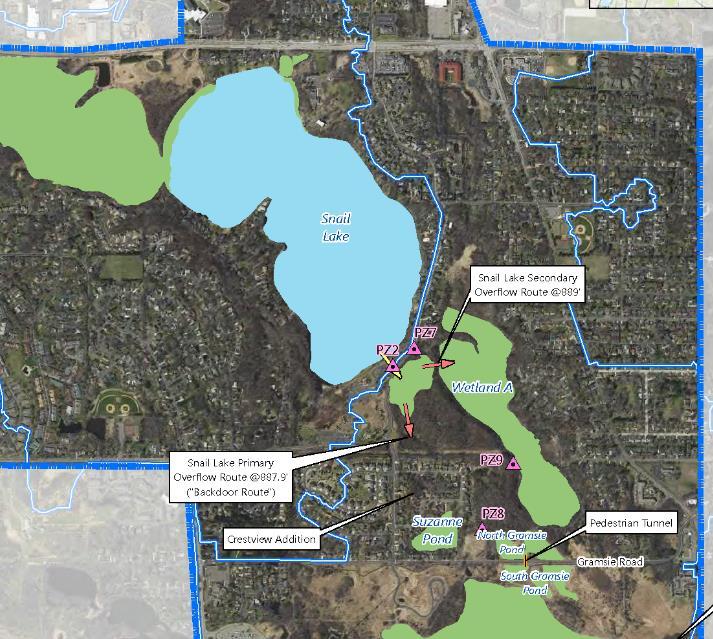
4 Snail Lake Snail Lake is land-locked (a.k.a. no piped outlet) Lake levels have been steadily rising over past several years Causing concerns for Snail Lake home flooding Causing concerns for potential overland overflow (should a very large event occur) that would likely flood homes in Crestview Addition

5 Grass Lake
6 Snail Lake Historical Elevations (source: MnDNR's Lake Finder website, elevations in 1912 datum) Annual Precipitation source: MN State Climatology Working Group /1/2009 5/16/2010 9/28/2011 2/9/2013 6/24/ /6/2015 3/20/2017 0
7 Elevation (ft, NAVD88) 894 Snail Lake Water Surface Elevation 2017 NAVD88 Datum Low Home Surveyed Elevation for 4322 Lake Point Ct: Snail Lake water levels Low Home Surveyed Elevation for 668 Highway 96W: Low Home Surveyed Elevation for 4154 Lake Point Ct: Low Home Surveyed Elevation for 4324 Lake Point Ct: Low Home Surveyed Elevation for 4320 Lake Point Ct: EXISTING OVERLAND OVERFLOW (a.k.a. : 887.9) Low Home Surveyed Elevation for 4380 Reiland Lane: Beach becomes unusable: Mar 25-Apr 14-Jun 3-Aug 22-Sep
8
9
10 Look for areas to: Store more flood water: Send discharge water to:

11 Study: Increase flood storage by creating a connection between Snail Lake and the wetland to the northwest of Snail Lake
")
12 Snail Lake Marsh (a.k.a. Little Snail)

13 Sign at the channel between Snail Lake and the wetland area to its northwest, indicating a fish spawning area
14 Conclusion and Recommendation Snail Lake Marsh is already being used to store Snail Lake flood water and has been properly accounted for in our hydrologic modeling. Recommendation: Do nothing further.
15 Evaluate the current level of risk of future flood levels on Snail Lake that could cause damage to habitable structures; evaluate these risks for three different management scenarios: 1) Do nothing further/implement Emergency Response Plan. 2) Lower West Vadnais Lake s 15-inch outlet under Highway 694 to an elevation of 881 to create more and add a Snail Lake outlet to Grass Lake. 3) Pump Snail Lake flood water to Sucker Lake.
16 Scenario 1 Do Nothing/Implement Emergency Response Plan
17 Scenario 1 Do Nothing/Implement Emergency Response Plan
18 Scenario 2 Pipe Snail and Lower West Vadnais Snail Ramsey County Parks VLAWMO Wetland A MN DNR SPRWS CITY OF SHOREVIEW Grass West Vadnais East Vadnais $620,000
19 Scenario 3 Pump Snail Lake Flood Water to Sucker Lake Snail Pump Sucker Ramsey County Parks VLAWMO MN DNR SPRWS CITY OF SHOREVIEW Grass West Vadnais East Vadnais $2,500,000+
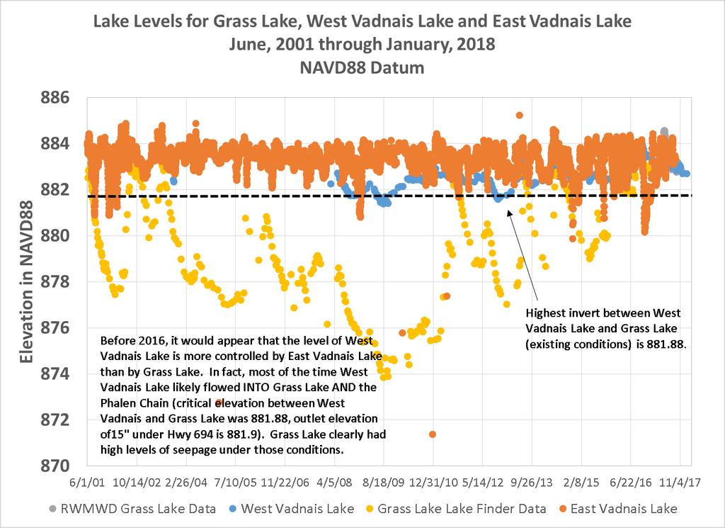
20 Conclusion and Recommendation Recommendations: Partner with the city of Shoreview to prepare and implement an emergency response plan for Snail Lake. Partner with the city of Shoreview and Ramsey County Parks and Recreation to install an off-peak drawdown pipeline that connects Snail Lake to Grass Lake. Include in the Emergency Response Plan actions to divert Snail Lake overland overflow from the backdoor path to Wetland A.
21 Wetland A Wetland A is land-locked (no piped outlet) and is the lowest point in the area. Water levels have remained high in Wetland A after Grass Lake flooded the wetland in Causing concerns for trail closures in park and limiting full usage of park.

22 April 24, 2018

23 Wetland A trail impacts
24 Wetland A Provide guidance for Ramsey County Parks and Recreation regarding the future levels in wetland A to inform future placement of trails.
25 Wetland A and Snail Lake water surface elevations shows a close correlation between the water level in these water bodies and associated groundwater tables. Elevation (ft, NAVD88) Water Surface Elevations of Wetland A and Area Piezometers Mar-17 5-May-17 4-Jul-17 2-Sep-17 1-Nov Dec-17 1-Mar Apr Jun-18 Wetland A Piezometer 8 Piezometer 9 Crestview Pond Piezometer 7 Piezometer 2 Snail Lake Snail Lake has been tracking with piezometer 2 Wetland A has been tracking just above piezometers 8 and 9
26 Recommendation for Wetland A Recommendation: Assist Ramsey County Parks and Recreation in choosing an alternative path alignment through the north and east sides of Wetland A that elevates the pathway to approximately elevation 876 (final elevation to be confirmed after the county conducts a soil and vegetation survey to better define the future alignment).
27 Grass Lake Evaluate flood management options: 1. Do nothing further. 2. Lower West Vadnais Lake s 15-inch outlet under Highway 694 to elevation 881.
28 West Vadnais Lake to East Vadnais Lake How do existing lake level conditions compare? East ~883 Existing East Vadnais West Existing West Vadnais Proposed Target for West Vadnais
29 Grass Lake Do nothing further
30 Grass Lake Lower West Vadnais Snail Ramsey County Parks VLAWMO MN DNR SPRWS CITY OF SHOREVIEW Grass West Vadnais East Vadnais $40,000
31 Grass Lake Lower West Vadnais (and Pipe Snail) Snail Ramsey County Parks VLAWMO Wetland A MN DNR SPRWS CITY OF SHOREVIEW Grass West Vadnais East Vadnais $40,000 + ($620,000)
32 Grass Lake Lower West Vadnais and Lower East Vadnais Lake Snail Ramsey County Parks VLAWMO MN DNR SPRWS CITY OF SHOREVIEW Grass West Vadnais East Vadnais Cost?
33 Recommendations Recommendation: Continue to pursue lowering the 15-inch pipe under Highway 694 with the DNR and VLAWMO to elevation But, only implement if East Vadnais Lake can be operated also at that elevation (881.0) to minimize the seepage of East Vadnais Lake water into West Vadnais Lake.
34 Grass Lake Evaluate decreasing draw down time 1. Do nothing further 2. Pump water from West Vadnais to East Vadnais 3. Promote infiltration of water from West to East, laterally, through the existing berm
35 Grass Lake/West Vadnais Lake Model estimated Drawdown Times No Pumping, 137 days 100 yr x 96 hr Target Peak WSE Note: the WSE of Grass Lake and West Vadnais Lake equalize 20 cfs, 36 days 10 cfs, 58 days 40 cfs, 19 days Target NWL
36
37
38 Grass Lake Pump West Vadnais to East Vadnais Snail Ramsey County Parks VLAWMO MN DNR SPRWS CITY OF SHOREVIEW Grass West Vadnais East Vadnais $2,500,000+
39 Grass Lake/West Vadnais Lake Model estimated Drawdown Times No Pumping, 137 days 100 yr x 96 hr Target Peak WSE Note: the WSE of Grass Lake and West Vadnais Lake equalize 20 cfs, 36 days 10 cfs, 58 days 40 cfs, 19 days Target NWL
40 Grass Lake Lower West Vadnais, Lower East Vadnais below West Vadnais Snail Ramsey County Parks VLAWMO MN DNR SPRWS CITY OF SHOREVIEW Grass West Vadnais East Vadnais Cost?
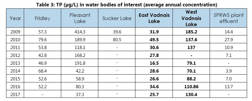
41 Next steps: Water quality and seepage assessment In-Lake Aeration In-Lake FeCl 3 addition 2017 Annual Average TP 60 µg/l Goal 130 µg/l West Vadnais Lake East Vadnais Lake TP Goal: 25 µg/l 27.5 µg/l
42 Recommendation Recommendation: 1. Continue to pursue further lowering of East Vadnais below West Vadnais with the SPRWS 2. Complete the proposed scope of work -West Vadnais Lake to East Vadnais Lake Gravity Flow Feasibility Evaluation per scope summary
43 North Gramsie Pond Manage the water level in North Gramsie Pond to Elevation 877 or lower and protect it from Grass Lake overflows (above Grass Lake elevation 884)
44 North Gramsie Pond - conclusions The data and modeling inferred that Wetland A can be as high as Elevation 880 with little to no measureable impact on groundwater levels in the vicinity of the Crestview Addition The North Gramsie Pond does influence groundwater levels in Crestview Addition. Manage at elevation 877 or lower to minimize related groundwater impacts. Suzanne Pond does influence groundwater levels in Crestview Addition. Manage at elevation 873 or lower to minimize related groundwater impacts.
45 North Gramsie Pond - recommendations Develop an emergency response plan to implement flow diverting, in the event Grass Lake overflows. Partner with the city of Shoreview to install a pipeline at elevation 877 with a manual gate valve to link the North Gramsie Pond to Suzanne Pond. Partner with the city of Shoreview to inspect the Suzanne Pond pumps and lift station and consider upgrading the pumps to increase their dependability and longevity. Partner with the city of Shoreview to prepare/agree on an operation and maintenance plan for Suzanne Pond pumping and North Gramsie gate valve operations.

46 Please refer to this summary table in the packet
47 If approved, what s next? Meet with the city and county to discuss potential partnering and cost implications associated with the recommended options. Prepare ERPs for Snail and Grass Lake and seek formal agreements by city to implement. Make formal request to SPRWS to operate EVL at for interim. Prepare scope of work for information and studies and discuss with DNR. Conduct seepage study per scope of work in handout.
48 Additional Slides


49 Studied Options Summary 1 of 6 2 of 6 3 of 6 4 of 6 5 of 6 6 of 6 Lower West Vadnais Pipe Snail and Lower West Vadnais Pump Snail Lower East Vadnais Lower East Vadnais & Lower West Vadnais Pump West Vadnais $40,000 $620,000 $2,500,000+?? $2,500,000+ Ramsey Co. Parks Ramsey Co. Parks Ramsey Co. Parks Ramsey Co. Parks VLAWMO VLAWMO VLAWMO VLAWMO VLAWMO VLAWMO MNDNR MNDNR MNDNR MNDNR MNDNR MNDNR Shoreview SPRWS SPRWS SPRWS SPRWS Shoreview
50 Incremental Implementation Study Complete Alternative Responses to Mitigating Flood Risk Raise Berm and Trail along Gramsie Road Lower Grass Lake Outlet to (2018 project) Cleanout channel to West Vadnais Outlet 15-Inch at 694: elevation Snail Lake to Grass Lake 15 Gravity Pipe (1.2 cfs) and Lower West Vadnais 15 Outlet to Pump Snail Lake Water to Sucker Lake Pump West Vadnais Water to East Vadnais Lower East Vadnais Water Level Emergency Flood Response Plan & Temporary Measures by City of Shoreview Benefits Lessens risk of Grass overflows to Wetland A Optimize Flow Capacity to West Vadnais Optimize Flow Capacity out of West Vadnais More flood storage More flood storage, active management of high lake levels More flood storage More flood storage Protect homes & infrastructure
 MnDNR")
51 Permitting needs 2 Cities Shoreview Vadnais Heights 3 Water Jurisdictions RWMWD VLAWMO SPRWS (Drinking Water) Crossing Two State Aid Roadways Wetlands at Pumping Inlet & Outlet Invasives Species East Vadnais (EWM, ZM) MnDNR Appropriations
52 How do existing water quality conditions compare? 93 µg/l Pumping from Mississippi River at Fridley Pleasant Lake 37.3 µg/l In-Lake Aeration 30 µg/l Snail Lake Grass Lake Sucker Lake In-Lake FeCl 3 addition 2017 Annual Average TP 60 µg/l Goal 130 µg/l West Vadnais Lake East Vadnais Lake TP Goal: 25 µg/l 27.5 µg/l
53
54 Next Steps Incremental Implementation Raise Berm and Trail along Gramsie Road benefits Lower Grass Lake Outlet to Cleanout channel to W. Vadnais Outlet 15-Inch at 694 West Vadnais water quality assessment for SPRWS (TP + MCL) West Vadnais to East Vadnais seepage assessment Emergency Response Plans City of Shoreview Snail emergency overflow change Study Underway Future? Lower East Vadnais Lake Level Study Complete Future? - Lower West Vadnais 15 Outlet to Study Complete Future? - Snail Lake to Grass Lake 15 Gravity Pipe etc.

55 What option(s) will best manage lake levels? Pumping? Berm Raise Optimize Outlet Grass Pumping? Outlet Cleanout/modification

56 West Vadnais Lake and East Vadnais Lake System Pumping and Related drawdown times For the critical event: 100 yr x 96 hr East Vadnais Lake NWL 883 ± 1 10 cfs 375 million gallons 58 day drawdown 408 lbs TP / year 20 cfs 462 million gallons 36 day drawdown 502 lbs TP / year West Vadnais Lake NWL cfs 489 million gallons 19 day drawdown 531 lbs TP / year
57 West Vadnais Lake to East Vadnais Lake Pumping Evaluation Model estimated West Vadnais Lake Drawdown No Pumping, 137 days 100 yr x 96 hr Target Peak WSE Note: the WSE of Grass Lake and West Vadnais Lake equalize 20 cfs, 36 days 10 cfs, 58 days 40 cfs, 19 days Target NWL
58 Can we pump West Vadnais Lake water to Saint Paul Regional Water Services (SPRWS)? From W. Vadnais
 Grass Lake Evaluated pumping Snail to Sucker Two alignment concepts 1.2 cfs, 10.0 cfs and 20.")
59 Snail Lake to Sucker Lake Pumping Evaluation Existing Snail Lake Augmentation pumping system Snail Lake pumping Sucker Lake Existing pumping Sucker to Snail Along Snail Lake Road 1,800 gpm (4 cfs) Grass Lake Evaluated pumping Snail to Sucker Two alignment concepts 1.2 cfs, 10.0 cfs and 20.0 cfs options Lake Owasso
60 Snail Lake to Sucker Lake Pumping Evaluation Model estimated Snail Lake Drawdown No Pumping, 200 days 1.2 cfs, 100 days, $1.0 million ($0.5 million to $2.2 million), 8 + pipe 20 cfs 10 cfs 882 Target 10 cfs, 24 days, $2.2 million ($1.0 million to $4.8 million), 1x24 pipe 20 cfs, 13 days, $3.5 million ($1.6 million to $7.6 million), 2x24 pipes Days
 100 yr x 96 hr Target Peak WSE Landlocked* lake with a wide range of surface elevations *No outlet below elevation 887.")
61 Snail Lake to Sucker Lake Pumping Evaluation Critical Event 100-yr, 96-hour EXISTING OVERLAND OVERFLOW (a.k.a. : 887.9) 100 yr x 96 hr Target Peak WSE Landlocked* lake with a wide range of surface elevations *No outlet below elevation overflow to Grass Lake
62 Can we pump Snail Lake water to Saint Paul Regional Water Services (SPRWS)? 38 million gallons (SPRWS avg. daily use) From Snail 80 million gallons (1.2 cfs critical event drawdown, 100 days) 160 million gallons (10 cfs critical event drawdown, 24 days) 170 million gallons (20 cfs critical event drawdown, 13 days)

63
Fisher Slough Tidal Marsh Restoration Project Scaling Down the Restoration Planning & Analysis Framework to Evaluate Project Alternatives
 Fisher Slough Tidal Marsh Restoration Project Scaling Down the Restoration Planning & Analysis Framework to Evaluate Project Alternatives Project Sponsor/Partners The Nature Conservancy Dike District #3
Lake Nokomis Shoreline Enhancement Project
 Lake Nokomis Shoreline Enhancement Project Community Meeting 2 February 13, 2018 Agenda Current Problems Project Goals Project Status Existing Conditions Community Input Draft Schematic Design Long-term
elm creek Watershed Management Commission
 elm creek Watershed Management Commission ADMINISTRATIVE OFFICE 3235 Fernbrook Lane Plymouth, MN 55447 PH: 763.553.1144 FAX: 763.553.9326 Email: judie@jass.biz Hickory Drive Utility & Street Improvements
PROJECT BACKGROUND. Preliminary Design Scope and Tasks
 PROJECT BACKGROUND Preliminary Design Scope and Tasks The purpose of this Study is the development of preliminary designs for intersection improvements for Trunk Highway (TH) 36 at the intersections of
Hydrologic Assessment of using Low Impact Development to Mitigate the Impacts of Climate Change. Chris Jensen, AScT Master of Science Thesis
 Hydrologic Assessment of using Low Impact Development to Mitigate the Impacts of Climate Change Chris Jensen, AScT Master of Science Thesis Bowker Creek Initiative April 12, 2012 Outline 1. Future Impacts
LOW IMPACT DEVELOPMENT GUIDANCE MANUAL AND LID WORKING GROUP ACTIVITIES. Powerpoint Templates. MS4 Statewide Stormwater Summit June 18, 2013
 LOW IMPACT DEVELOPMENT GUIDANCE MANUAL AND LID WORKING GROUP ACTIVITIES MS4 Statewide Stormwater Summit June 18, 2013 Powerpoint Templates Evan Canfield, Ph.D, P.E. Pima County Regional Flood Control Outline
Information for File MVP MMJ; CSAH 10 Reconstruction (Waconia and Watertown Townships)
") Information for File MVP-2014-03830-MMJ; Reconstruction (Waconia and Watertown Townships) Applicant: Carver County Corps Contact: Melissa Jenny Address: 180 Fifth Street East, Suite 700, St. Paul, MN 55101
Information for File MVP-2014-03830-MMJ; Reconstruction (Waconia and Watertown Townships) Applicant: Carver County Corps Contact: Melissa Jenny Address: 180 Fifth Street East, Suite 700, St. Paul, MN 55101
Southeast Extension to RidgeGate Parkway Scoping Booklet
 Southeast Extension to RidgeGate Parkway Scoping Booklet PUBLIC SCOPING MEETING SCHEDULE Public Scoping Meeting Wednesday, November 2, 2011 6:00pm to 7:30pm City of Lone Tree Recreation Center Willow Room
The Benefits and Challenges Associated with Green Infrastructure Practices
 The Benefits and Challenges Associated with Green Infrastructure Practices Thomas M. Evans ASLA, LEED AP Regional Green Infrastructure Design Services Director OWEA Technical Conference, June 20, 2013
1.0 INTRODUCTION 1.1 TH 14 WEST STUDY AREA Project Description Functional Classification Purpose of the Project
 1.0 INTRODUCTION 1.1 TH 14 WEST STUDY AREA 1.1.1 Project Description The Trunk Highway (TH) 14 West Corridor is a two-lane roadway approximately 22 miles in length. Located in Nicollet County, the corridor
Selecting Least Cost Green Infrastructure. James W. Ridgway, PE September 29, 2015
 Selecting Least Cost Green Infrastructure James W. Ridgway, PE September 29, 2015 Integrated Water Management?? IS GREEN INFRASTRUCTURE LESS COSTLY THEN GRAY INFRASTRUCTURE? Cost of Green Infrastructure
City of Elmhurst. City of Elmhurst. Storm Sewer System Workshop November 22, 2010
 City of Elmhurst City of Elmhurst Storm Sewer System Workshop November 22, 2010 1 City of Elmhurst Watershed divide (green dashed line) through Elmhurst Area east of divide drains to Addison Creek Area
I-494 Rehabilitation Project SP (I-394 to Fish Lake Interchange) June 2014 Section 4(f) De Minimis Determination
 June 2014 Section 4(f) De Minimis Determination") I-494 Rehabilitation Project SP 2785-330 (I-394 to Fish Lake Interchange) June 2014 Section 4(f) De Minimis Determination State Project Number 2785-330 Federal Project No. NHPP-I494 (002) Trunk Highway:
I-494 Rehabilitation Project SP 2785-330 (I-394 to Fish Lake Interchange) June 2014 Section 4(f) De Minimis Determination State Project Number 2785-330 Federal Project No. NHPP-I494 (002) Trunk Highway:
4/8/2015 Item #10D Page 1
 MEETING DATE: April 8, 2015 PREPARED BY: Christy Villa, Associate Civil Engineer DEPT. DIRECTOR: Glenn Pruim DEPARTMENT: Public Works CITY MANAGER: Larry Watt SUBJECT: NORTH COAST HIGHWAY 101 STREETSCAPE
Welcome. Tannery and Waterworks Parks Shoreline Improvements Environmental Assessment. Public Information Centre #1 November 27, pm to 8 pm
 Welcome Tannery and Waterworks Parks Shoreline Improvements, Environmental Assessment Tannery and Waterworks Parks Shoreline Improvements Environmental Assessment #1 6 pm to 8 pm Why We Are Here Tannery
Low Impact Development Calculations using the Source Loading and Management Model (WinSLAMM)
") Low Impact Development Calculations using the Source Loading and Management Model (WinSLAMM) Robert Pitt Department of Civil, Construction, and Environmental Engineering The University of Alabama, Tuscaloosa,
Low Impact Development Calculations using the Source Loading and Management Model (WinSLAMM) Robert Pitt Department of Civil, Construction, and Environmental Engineering The University of Alabama, Tuscaloosa,
Roof Runoff Harvesting Benefits for Regional Conditions in Low Density and Medium Density Residential Areas. Leila Talebi 1 and Robert Pitt 2
 Roof Runoff Harvesting Benefits for Regional Conditions in Low Density and Medium Density Residential Areas Leila Talebi 1 and Robert Pitt 2 1Graduate Student, Department of Civil, Construction, and Environmental
Regional Open Space Conservation Plan. Regional Staff Committee January 18, 2018
 Regional Open Space Conservation Plan Regional Staff Committee January 18, 2018 Schedule We are here Task 1 - Stakeholder Input & Work Plan Dev. v z 2016 2017 2018 Oct Nov Dec Jan Feb Mar Apr May Jun Jul
Public Meeting #3 May 9, 2009 MVVA Team
 Public Meeting #3 May 9, 2009 MVVA Team Welcome to the third Public Meeting for the Lower Don Lands Municipal Class Environmental Assessment (EA) Infrastructure Master Plan and Keating Channel Precinct
Purpose of Open House #3
 Public Meeting #3 May 9, 2009 MVVA Team Purpose of Open House #3 The main purpose of this Open House is to present and seek input on the: Evaluation of transportation and infrastructure design alternatives
Don t Flood The Rodeo! Preparing for Fort Worth s New Arena
 Don t Flood The Rodeo! Preparing for Fort Worth s New Arena T F M A S P R I N G C O N F E R E N C E APRI L 27 2017 Scott Hubley, P.E., CFM Justin Oswald, P.E., CFM Christopher Johnson, P.E., CFM PHOTO
Welcome to the. Open House
 Welcome to the 5th Street to Kinsman Road Open House November 14 5:30 7:00 p.m. Please sign in Project Overview In December 2016, City Council adopted SW 5th Street as the preferred alignment to connect
Sustainable Hot Water: Better Design, Delivery, and Use
 Sustainable Hot Water: Better Design, Delivery, and Use March 24, 2009 Don Fisher Amin Delagah Fisher-Nickel, inc. PG&E Food Service Technology Center The Food Service Technology Center (FSTC) program
Peace River Water Use Plan Dinosaur Reservoir Management Plan
 Peace River Water Use Plan Dinosaur Reservoir Management Plan Monitoring Programs and Physical Works Annual Report 2016 Implementation Period: June 2015 to May 2016 GMSMON-14 DNR Tributary Habitat Review
Brigitte A. Berger, Director of Engineering
 Brigitte A. Berger, Director of Engineering Wilmette s Sewer System Overview of Wilmette s Sewer System Green vs. Gray? Stormwater Action Plan Regulatory Compliance Why Homes Flood What can
STAFFORD TRACT NORTH OF US90A 1.0 INTRODUCTION 1.1 OBJECTIVE
 1.0 INTRODUCTION 1.1 OBJECTIVE This report, prepared for submittal to TxDOT, analyzes existing and proposed detention facilities draining into the TxDOT US90A storm sewer system. The results of the detailed
Energy & Water Savings in Commercial Food Service
 Energy & Water Savings in Commercial Food Service Don Fisher Manager Food Service Technology Center 925-866-5770 dfisher@fishnick.com The Food Service Technology Center (FSTC) program is funded by California
Copyright 2003 IBACOS, Inc. All rights reserved.
 Domestic Hot Water Research Research conducted by Bill Rittelmann Presented by Duncan Prahl Partners for High Performance Homes Meeting Westminster, CO, June 23, 2005 DHW Systems: Current Technologies
Severn River Sub-Watershed: BMP 09-Retrofit
 Project ID: BMP_09 Total Treated Drainage Area: 4.57 acres Total Treated Impervious Area: 2.9 acres Total Water Quality Volume (WQv): ~10,300 cubic feet; 0.236 acre-foot Rainfall Depth Treated (Pe): 1
WHAT IS THE PURPOSE OF THE OPEN HOUSE?
 WHAT IS THE PURPOSE OF THE OPEN HOUSE? OPEN HOUSE PURPOSE The purpose of the open house is to provide an update on the study process and introduce the preliminary concept alternatives. The open house provides
Section 1 TABLE OF CONTENTS
 Section 1 TABLE OF CONTENTS... [M]ineral fertilizer is essential to feed around half of the world s population, and will be fundamental to ensure global food security through the 21 st century. 2013 U.N.
Green Roofs and Stormwater Management Virginia Stovin
 Green Roofs and Stormwater Management Virginia Stovin Department of Civil and Structural Engineering Pennine Water Group University of Sheffield Outline Urban stormwater management Conventional solutions,
PROJECT SCOPE OF WORK CITY OF TOWN AND COUNTRY STORMWATER PROGRAM
 PROJECT SCOPE OF WORK CITY OF TOWN AND COUNTRY STORMWATER PROGRAM Project Name: 362 Featherstone Dr Project ID Number: 27-3 Problem: Anecdotal evidence suggests a natural spring exists in the backyard
Green. Clean Water. Trees, Roots, and their Role in Stormwater Management. By John Bilotta
 Green Infrastructure for Clean Water Trees, Roots, and their Role in Stormwater Management By John Bilotta Green Infrastructure for Clean Water: Trees, Roots, and their Role in Stormwater Management September
Strategies for Summer Utility Savings. Residential Environmental Program Series May 15, 2013
 Strategies for Summer Utility Savings Residential Environmental Program Series May 15, 2013 Are FC Summers Getting Hotter? 200 Fort Collins Annual Hours 90 F or Above 150 100 50 1970 1980 1990 2000 2010
BASS PONDS, MARSH, & WETLAND HABITAT RESTORATION PROJECT
 FACT SHEET BASS PONDS, MARSH, & WETLAND HABITAT RESTORATION PROJECT MINNESOTA VALLEY NATIONAL WILDLIFE REFUGE, MINNESOTA ENVIRONMENTAL MANAGEMENT PROGRAM LOCATION Three areas located on the Minnesota Valley
WLAC Facilities Committee Meeting. September 18, 2017
 Campus Program Report WLAC Facilities Committee Meeting September 18, 2017 Page 1 DSA approved the plans on May 15, 2017. Notice to Proceed was issued June 8, 2017 and the project remains on schedule for
Identification of Aberrant Railroad Wayside WILD and THD Detectors: Using Industry-wide Railroad Data. June 10, 2014
 Identification of Aberrant Railroad Wayside WILD and THD Detectors: Using Industry-wide Railroad Data June 10, 2014 1 Agenda Background / Overview Solution Approach Groupings Criteria Sites Speed Weight
Pond Siting Report Update
 Pond Siting Report Update Prepared for: Florida Department of Transportation District 5 CR 46A Realignment from SR 46 to North of Arundel Way Lake County, Florida FPID No. 238275-8-32-02 October 2013 (Draft
TOWN OF NEW CASTLE - Master Plan Update
 Our Presentation Today (1) Recap the Master Planning Process To Date (2) Present the Outline of the Master Planning Work Plan (3) Present the Calendar for the Master Plan (4) Outline the scope of a Downtown
Old Mill Community Association Bioretention Facility
 Project Overview This project will install a bioretention facility in a community recreation area owned by the Old Mill Community Association, Inc. Drainage from the area is currently unmanaged and has
Mendota-Lebanon Hills Greenway Master Plan Executive Summary. August draft for more information visit
 Mendota-Lebanon Hills Greenway Master Plan Executive Summary August 2013 draft for more information visit www.hkgi.com/projects/dakota INTRODUCTION The Mendota-Lebanon Hills Greenway Master Plan portrays
South Bismarck Watershed Model Update and Stormwater Improvement Project
 Preliminary Engineering Report Bismarck Tribune South Bismarck Watershed Model Update and Stormwater Improvement Project City of Bismarck, ND January 2017 14.105.0046 1.0 Executive Summary The focus of
Keele Campus Storm Drainage. Presented by Mark Hagesteijn September 24, 2013
 Keele Campus Storm Drainage Presented by Mark Hagesteijn September 24, 2013 1 Presentation Overview Urbanization Impact on the Hydrologic Cycle Why Do We Manage Stormwater? Typical Stormwater Management
COMMUNITY DEVELOPMENT DEPARTMENT POLICY DRAINAGE FOR RESIDENTIAL PROJECTS WITH ONE OR TWO UNITS REVISED JANUARY 4, 2018
 COMMUNITY DEVELOPMENT DEPARTMENT POLICY DRAINAGE FOR RESIDENTIAL PROJECTS WITH ONE OR TWO UNITS REVISED JANUARY 4, 2018 A. California Residential Code Requirement - Construction plans shall indicate how
Southeast Michigan Council of Governments
 Southeast Michigan Council of Governments SEMCOG Green Infrastructure Activities Regional Green Infrastructure Vision GLRI Green Streets EPA Technical Assistance MDOT Grants Green Infrastructure Vision
RESPONSES TO PUBLIC CONCERNS AND QUESTIONS
 RESPONSES TO PUBLIC CONCERNS AND QUESTIONS Stations and Summary Questions for Public Meeting #2 June 23, 2015 General Questions / Concerns: 1. Is there any way this development can raise revenue for the
Draft Rhode Island Stormwater Design and Installation Standards Manual
 Draft Rhode Island Stormwater Design and Installation Standards Manual Summary The May 2009 Public Review Draft version of the RI Stormwater Design and Installation Standards Manual consists of approximately
The Effects of Woody Vegetation on Levees
 The Effects of Woody Vegetation on Levees Maureen K. Corcoran Assistant Technical Director, Water Resources Infrastructure Vicksburg, MS 26 February 2010 US Army Corps of Engineers Problem Statement What
Rainwater Harvesting: Where does the Rainfall Go?
 Rainwater Harvesting: Where does the Rainfall Go? Justin Mechell Extension Assistant Department of Biological and Agricultural Engineering Texas A&M University Objectives Understand a watershed and how
SOUTH FOX MEADOW STORMWATER IMPROVEMENT PROJECT
 VILLAGE OF SCARSDALE WESTCHESTER COUNTY, NEW YORK COMPREHENSIVE STORM WATER MANAGEMENT SOUTH FOX MEADOW STORMWATER IMPROVEMENT PROJECT In association with WESTCHESTER COUNTY FLOOD MITIGATION PROGRAM Rob
2012 Saginaw Bay Watershed Conference
 2012 Saginaw Bay Watershed Conference March 16, 2012 Russ Beaubien, P.E., CFM Low Impact Development Fundamentals Summary LID overview Education on LID Fundamentals of LID Examples of LID practices Other
LAKE JOHANNA FIRE DEPARTMENT
 LAKE JOHANNA FIRE DEPARTMENT 2017 ANNUAL FIRE REPORT REPORT PREPARED BY: DEBI KRAUSE OFFICE MANAGER & TIM BOEHLKE FIRE CHIEF Lake Johanna Fire Department 2017 Annual Fire Report In 2017 the Lake Johanna
Development and Design of Cost-Effective, Real-Time Implementable Sediment and Contaminant Release Controls
 Development and Design of Cost-Effective, Real-Time Implementable Sediment and Contaminant Release Controls Richard Warner, Ph.D. Biosystems and Agricultural Engineering Department University of Kentucky
TENNESSEE GAS PIPELINE COMPANY, L.L.C.
 TENNESSEE GAS PIPELINE COMPANY, L.L.C. HYDROLOGIC AND HYDRAULIC CALCULATIONS FOR ACCESS ROADS ALONG THE CONNECTICUT PIPELINE EXPANSION PROJECT CONNECTICUT LOOP Submitted by: Tennessee Gas Pipeline Company,
SF REC & PARK STANYAN STREET IMPROVEMENT. Supervisor London Breed District 5. Project Manager Dan Mauer Recreation and Parks Department
 SF REC & PARK STANYAN STREET IMPROVEMENT PLANNING PRESENTATION WEDNESDAY, OCTOBER 19, 2016 Supervisor London Breed District 5 Project Manager Dan Mauer Recreation and Parks Department Design Team William
MASTER PLAN KICK-OFF Open House #1A, April 28, 2015
 "The beginning is the most important part of the work." Plato, The Republic MASTER PLAN KICK-OFF Open House #1A, April 28, 2015 YOUR CAMPUS PLANNING TEAM Campus Planners Landscape Architects Urban Designers
PRE-DESIGN CONCEPT REPORT GRAND CANAL RESTORATION
 PRE-DESIGN CONCEPT REPORT GRAND CANAL RESTORATION Project Background November 19, 2007 Executive Summary The Grand Canal is an important tidal waterway in the Venice community of Los Angeles, California,
SF REC & PARK MOSCONE RECREATION CENTER: EAST SITE. Supervisor Mark Farrell District 2. Project Manager Dan Mauer Recreation and Parks Department
 SF REC & PARK MOSCONE RECREATION CENTER: EAST SITE COMMUNITY WORKSHOP: MEETING #3 WEDNESDAY, FEBRUARY 10, 2016 Supervisor Mark Farrell District 2 Project Manager Dan Mauer Recreation and Parks Department
water resource specialists
 Vaughn Collins, PE, CFM, Northwest Hydraulic Consultants Brad Livingston, Oregon Department of Transportation Melissa Reich, North Coast Land Conservancy Location Necanicum River 75 sq mi watershed Active
STORMWATER MANAGEMENT PLAN: ERAND GARDENS X70
 STORMWATER MANAGEMENT PLAN: ERAND GARDENS X70 Client: Central Developments 09 April 2018 _ Rev00 Report no: SWMP/410/00 SWMP FOR ERAND GARDENS X70 TABLE OF CONTENTS 1 INTRODUCTION... 1 2 GENERAL INFORMATION...
Information for File # MMW
 Information for File #07-0870-MMW Applicant: Menards (Tyler Edwards) Corps Contact: Mariah Weitzenkamp Address: 80 Fifth Street East, Suite 700, Saint Paul, MN 0-78 E-Mail: Mariah.M.Weitzenkamp@usace.army.mil
Low Impact Development. Charlene LeBleu Auburn University Landscape Architecture (334)
") Low Impact Development Charlene LeBleu Auburn University Landscape Architecture leblecm@auburn.edu (334) 844-0192 What is Low Impact Development? Infiltrate Filter Store Evaporate Detain An innovative
Low Impact Development Charlene LeBleu Auburn University Landscape Architecture leblecm@auburn.edu (334) 844-0192 What is Low Impact Development? Infiltrate Filter Store Evaporate Detain An innovative
TIRZ 17/Redevelopment Authority Capital Improvements Plan Projects
 Gessner Widening: T-1701 What: Widen the road from a six-lane divided boulevard to an eight-lane divided boulevard street section, increase turn lanes, update traffic signal system, improve drainage by
7.0 SOCIAL, ECONOMIC, AND ENVIRONMENTAL ISSUES
 7.0 SOCIAL, ECONOMIC, AND ENVIRONMENTAL ISSUES The following list of social, economic, and environmental issues have been identified based on a preliminary inventory of resources in the project area, an
Stormwater Retrofitting: The Art of Opportunity. Presented by the Center for Watershed Protection
 Stormwater Retrofitting: The Art of Opportunity Presented by the Center for Watershed Protection What Are Stormwater Retrofits? Retrofits are stormwater management measures inserted in an urban or ultra-urban
Goals and Strategies. Goals. Strategies. Long-term Beach and Shoreline Management Program
 Goals and Strategies Goals Long-term Beach and Shoreline Management Program Qualify for and Maintain Static-line Exception Qualify for and Maintain FEMA Engineered Beach Lockwoods Folly Inlet Management
4.5 City of Indianapolis Stormwater Green Infrastructure Guidance: Bioretention (rain gardens) Bioretention Fact Sheet Bioretention Technical Design
 Bioretention Fact Sheet Bioretention Technical Design") 4.5 City of Indianapolis Stormwater Green Infrastructure Guidance: Bioretention (rain gardens) Bioretention Fact Sheet Bioretention Technical Design Specification Bioretention O & M Manual Draft Green
4.5 City of Indianapolis Stormwater Green Infrastructure Guidance: Bioretention (rain gardens) Bioretention Fact Sheet Bioretention Technical Design Specification Bioretention O & M Manual Draft Green
Evaluation of How O&M Costs Vary for Alternative Flood Control Strategies
 Evaluation of How O&M Costs Vary for Alternative Flood Control Strategies Fargo-Moorhead Diversion Channel ASFPM Conference June 13, 2013 Matt Redington, PE Jeremy Cook HDR Engineering Red River of the
WASHINGTON COUNTY OREGON
 WASHINGTON COUNTY OREGON LONG RANGE PLANNING DIVISION North Bethany Subarea Stream Corridors: Existing Regulations In Oregon, there is a distinct difference between the land use rules that apply in rural
BRISBANE BAYLANDS INFRASTRUCTURE PLAN FEBRUARY 2011 APPENDIX O DRAFT
 BRISBANE BAYLANDS INFRASTRUCTURE PLAN FEBRUARY 2011 APPENDIX O DRAFT PRELIMINARY STORM DRAIN CALCULATIONS ASSOCIATED WITH BRISBANE BAYLANDS REDEVELOPMENT BRISBANE, CALIFORNIA Prepared by BKF Engineers
RESILIENCY, ADAPTATION, & SUSTAINABILITY AT THE CITY OF ST. AUGUSTINE
 RESILIENCY, ADAPTATION, & SUSTAINABILITY AT THE CITY OF ST. AUGUSTINE PROGRAM UPDATE JANUARY 14, 2019 MICHAEL G. CULLUM, P.E. DIRECTOR, PUBLIC WORKS PROGRESSION OF PLANNING FOR RESILIENCY / ADAPTATION
Potential Outdoor Water Savings of Los Angeles Abstract Introduction
 Potential Outdoor Water Savings of Los Angeles Tsukiko Jerger, Nicole Puma, Andrew Tom, Nargis Walai Section A02 Abstract In Southern California, water is in short supply and in high demand. This is sharply
Port of San Diego Sea Level Rise Ad Hoc Committee Meeting 1 of 3.. September 18, 2018
 Port of San Diego Sea Level Rise Ad Hoc Committee Meeting 1 of 3. September 18, 2018 Agenda Welcome Introductions Rules of the Ad-Hoc Presentation Background Vulnerability Assessment Results Non-Agenda
7th Avenue Creek Master Plan Development Project. City of St. Charles, IL. IAFSM CONFERENCE March 14, 2018 MARKET
 7th Avenue Creek Master Plan Development Project MARKET City of St. Charles, IL IAFSM CONFERENCE March 14, 2018 7 TH AVENUE CREEK PROJECT AREA 2 2008 RAIN EVENT 3 RESIDENTIAL STRUCTURE FLOODING COMMERCIAL
Mississippi Skyway Preliminary Engineering Report
 EXECUTIVE SUMMARY Mississippi Skyway Preliminary Engineering Report CITY OF RAMSEY, MINNESOTA DECEMBER 2014 City of RAMSEY EXECUTIVE SUMMARY Project Need and Intent The Mississippi Skyway pedestrian bridge
MassDOT Highway ACEC State Markets Conference April 4, Jonathan Gulliver, Highway Administrator
 MassDOT Highway ACEC State Markets Conference April 4, 2019 Jonathan Gulliver, Highway Administrator About MassDOT Highway 9,561 Lane Miles of Interstate, Numbered Routes, and Toll Roads 60% of all trips
Modeling Cumulative LID Features for Floodplain Impacts in an Urban Watershed in Houston, TX
 Modeling Cumulative LID Features for Floodplain Impacts in an Urban Watershed in Houston, TX Christina Hughes, Phil Bedient cmhughes@rice.edu May 2, 2014 1 Modeling Cumulative LID Features for Floodplain
Blue/Green Infrastructure Study Accomack County, VA
 Blue/Green Infrastructure Study Accomack County, VA Draft Asset Maps March 8-9, 2010 Green Infrastructure Center, Inc. 2 Overview What is Green and Blue Infrastructure Project Timeline & Tasks Literature
The West Vaughan Employment Area Secondary Plan Policies
 Part 2: The West Vaughan Employment Area Secondary Plan Policies 2.1 General Policies It is the policy of Council: 2.1.1. That the West Vaughan Employment Area (the WVEA), identified on Schedule 1, will
Heritage Park Irrigation System Inspection Review of Water Use Estimated Water Budget Potential for Savings
 Heritage Park Irrigation System Inspection Review of Water Use Estimated Water Budget Potential for Savings Site Visit: January 17, 2008 Address: 611 Village Drive, Suisun City Key Action Items Re-nozzle
Highlights from WERF Stormwater Research and Future Opportunities
 Highlights from WERF Stormwater Research and Future Opportunities Jeff Moeller, P.E. Director of Water Technologies Water Environment Research Foundation jmoeller@werf.org WEFTEC 2013 Stormwater Pavilion
Storm Water Management Workshop
 Storm Water Management Workshop The following questions were asked during the breakout sessions for the Storm Water Management Workshops held on February 26, 2018 and March 2, 2018. Wildlife / Vegetation
New Westminster Downtown Parking Strategy Public Open House #1 September 13, 2012
 New Westminster Downtown Parking Strategy Public Open House #1 September 13, 2012 The City is preparing a strategy for parking in Downtown New Westminster. The study team and a group of key stakeholders
Our Wetland Restoration Plan
 Our Wetland Restoration Plan Name/Property name Date Wetland Restoration/Management Template SITE DETAILS Owner Occupier (if different to owner) Location (e.g. access/street address, topographic grid reference
SECTION 4(f) DE MINIMIS DOCUMENTATION
 DE MINIMIS DOCUMENTATION") SECTION 4(f) DE MINIMIS DOCUMENTATION Illinois Route 60/83 IL 176 to the intersection of IL 60 (Townline Road) Lake County P-91-084-07 Mundelein Park and Recreation District Project Limit SECTION 4(f)
SECTION 4(f) DE MINIMIS DOCUMENTATION Illinois Route 60/83 IL 176 to the intersection of IL 60 (Townline Road) Lake County P-91-084-07 Mundelein Park and Recreation District Project Limit SECTION 4(f)
April 11, 2016 Park Board Chair and Commissioners General Manager Vancouver Board of Parks and Recreation New Brighton Salt Marsh - Preferred Concept
 TO: FROM: SUBJECT: April 11, 2016 Park Board Chair and Commissioners General Manager Vancouver Board of Parks and Recreation New Brighton Salt Marsh - Preferred Concept RECOMMENDATION A. THAT the Vancouver
Leduc Industrial Outline Plan SE W4
 Leduc Industrial Outline Plan SE 1-50-25-W4 Within the North Leduc Industrial ASP Prepared for: Leduc Energy Park Ltd. Prepared by: Stantec Consulting Ltd. File No. 1161 104655 V5 Table of Contents 1.0
Irrigating Olives. Janet Caprile UCCE Farm Advisor Alameda & Contra Costa Counties
 Irrigating Olives Janet Caprile UCCE Farm Advisor Alameda & Contra Costa Counties Olive Production Basics: Introduction to Irrigation Management Sunday, July 21, 1 3:30 pm, Livermore Why do olives need
Public Information Centre # 2 Coronation Park Drainage Improvements Town of Oakville Municipal Class Environmental Assessment
 November 26, 2014 Public Information Centre # 2 Coronation Park Drainage Improvements Town of Oakville Municipal Class Environmental Assessment Study Area & Drainage System Legend Coronation Project Park
13 Maintenance and Operations Plan 223
 222 13 Operations Maintenance and Plan 223 Chapter 13 MAINTENANCE AND OPERATIONS PLAN 13.1 Stewardship The Minneapolis Park and Recreation Board (MPRB) is the steward of a nationally-acclaimed park system.
Access. Chapel Parking & Entry Loop Snowbridge Square Skier/Visitor Parking. Dumpster Access. 3 Entry Monument Future Chapel Park
 EXHIBIT 1.1: RENDERED PLAN & CHARACTER Surrounding landscape patterns reach into the site connecting the new hotel to the surrounding resort. Guests are lead towards the hotel entry via the aspen wave
DRAFT SECTION 4(f) EVALUATION INTERSTATE 73 FEIS: I-95 to I-73/I-74 in North Carolina
 EVALUATION INTERSTATE 73 FEIS: I-95 to I-73/I-74 in North Carolina") DRAFT SECTION 4(f) EVALUATION INTERSTATE 73 FEIS: I-95 to I-73/I-74 in North Carolina 1.0 INTRODUCTION Section 4(f) of the Department of Transportation Act of 1966, 49 U.S.C. 303, requires that prior to
DRAFT SECTION 4(f) EVALUATION INTERSTATE 73 FEIS: I-95 to I-73/I-74 in North Carolina 1.0 INTRODUCTION Section 4(f) of the Department of Transportation Act of 1966, 49 U.S.C. 303, requires that prior to
Importance of Master Planning Marcy Colclough
 Importance of Master Planning Marcy Colclough Senior Planner Southwest Michigan Planning Commission WHERE and HOW we develop Land affects Water Quality! 43.2 Acres total 20 Homes 35.8 Acres of open space
Kimberly Rollins, Professor, Department of Economics, University of Nevada, Reno
 Modeling Multiple Factors of Residential Water Demand to Assess Price and Non-Price Instruments under Climate Change: An Application to Las Vegas, Nevada Kimberly Rollins, Professor, Department of Economics,
Patrick E. Lindemann INGHAM COUNTY DRAIN COMMISSIONER. Towar Rain Garden Drains A Low-Impact Urban Retrofit
 : A Michigan Urban Retrofit Low Impact Stormwater Management System What Color is Your Infrastructure? 2011 LID Symposium Philadelphia September 28, 2011 Twenty percent of the world s available fresh water
WQ-23 MOUNTAINOUS AND STEEP SLOPE SITES
 Greenville County Technical Specification for: WQ-23 MOUNTAINOUS AND STEEP SLOPE SITES 1.0 Mountainous and Steep Slope Sites 1.1 Description The geographic locations of portions of Greenville County are
Sustainable Stormwater Management with Low Impact Development (LID)
") Sustainable Stormwater Management with Low Impact Development (LID) Chui Ting Fong, May Department of Civil Engineering The University of Hong Kong HKIE Seminar Nov 27, 2014 1 Hydrologic Impact of Urbanization
Sustainable Stormwater Management with Low Impact Development (LID) Chui Ting Fong, May Department of Civil Engineering The University of Hong Kong HKIE Seminar Nov 27, 2014 1 Hydrologic Impact of Urbanization
Analogue to Digital Telecare. Technical Advisory Board. 21 st June 2017 Work Stream 3 Procurement
 Analogue to Digital Telecare Technical Advisory Board 21 st June 2017 Work Stream 3 Procurement Euan Kidd Senior Procurement Specialist Euan.kidd@scotland-excel.org.uk 1 Purpose of Work stream 3 - procurement
Three Rivers Park District Administration Center Rain Garden
 Three Rivers Park District Administration Center Rain Garden Introduction There are significant changes to the hydrologic regime and nutrient loading following urban and industrial development. The post-development