December 13, 2005 Meeting Status of NPDES Post Fire BMPs
|
|
|
- Clare Walton
- 6 years ago
- Views:
Transcription
1 December 13, 2005 Meeting Status of NPDES Post Fire BMPs Agenda Overview of Current Operations At SSFL Impacts of Fire At SSFL Rebuilding & Improvement of BMPs Future Activities Site Tour Close-out 1

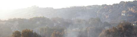
2 Santa Susana Field Laboratory Regional Map 2
3 SSFL Operations Generating Discharges Current & Future Operations Rocket Engine Testing 2005 Approximately 17 engine tests 2006 Possibly one more Sewage Treatment Plant Operations Two days of operation due to high volume of flow from rain None expected due to sewer line repairs and capping of old sewer lines. Groundwater Treatment Systems 2005 Treatment occurred using some systems Resumption of treatment to be coordinated with DTSC. 3
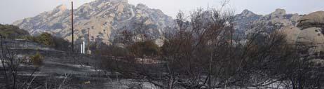
4 Impact To SSFL as a Result of September 2005 Fire 4

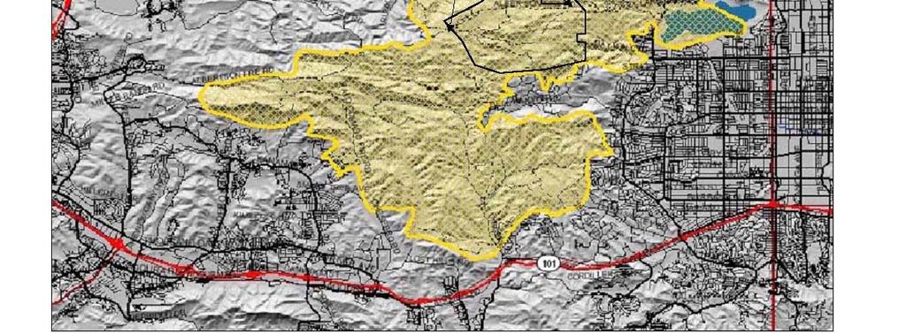
5 2005 Fire Boundary 5


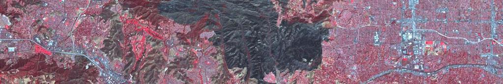
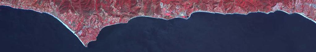
6 October 4 th NASA IR-Image 6

7 Fires Not Uncommon in Area 7
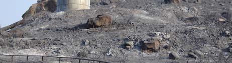
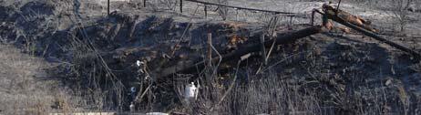
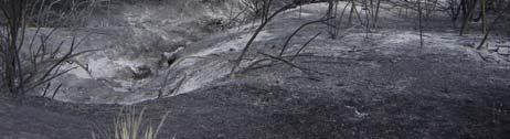
8 Impact of September 2005 at SSFL Brush burned on over 2,000 acres of the site. 10 of the 200 structures were damaged by fire with 7 destroyed. Over 300 telephone and power poles were destroyed. High Density Polyethylene (HDPE) pipelines from the groundwater remediation systems were destroyed. DTSC, DOE, DHS, VCEHD, RWQCB and various fire departments have been on site to inspect and assess the fire damage. 8

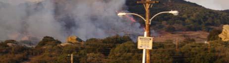

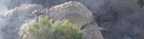
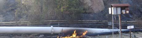


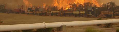

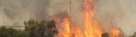

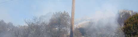
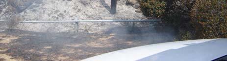
9 September 2005 Fire At SSFL 9

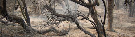
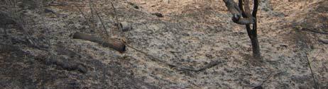

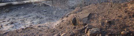


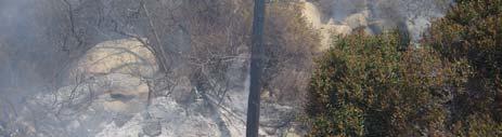

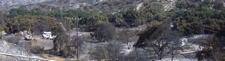
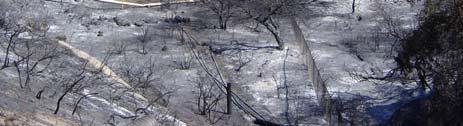
10 A Few Days After 10
11 Post Fire Re-building Efforts Debris from destroyed buildings removed. Electricity restored to the site, phone & internet connections still being restored. Telephone poles being removed. BMPs re-built & improved. 11


12 Santa Susana Field Laboratory Surface Water NPDES Outfall Locations N SIMI VALLEY Black Canyon Woolsey Canyon Undeveloped Land BELL CANYON 970xxxxc.ppt aw/jhs 12
. Dense natural vegetation along entire length of drainage.")
13 Outfall 001 (Southeast) Before 2005 Fire BMPs In Place Upstream settling pond (Perimeter Pond). Dense natural vegetation along entire length of drainage. 13

14 Outfall 001 (Southeast) After 2005 Fire BMPs Damaged Vegetation along streambed either completely destroyed or heavily damaged. Hillsides along drainage covered in ash that is known to contain elevated levels of naturally occurring metals and dioxins. 14

15 Outfall 001 (Southeast) 2 Months after 2005 Fire BMPs Implemented Straw wattles installed along burned areas of drainage. Straw bales placed in 001 streambed. Straw bales placed in tributary streambeds. Straw wattles and bales placed upstream. 15
")


16 Outfall 002 (Southwest) Before 2005 Fire BMPs In Place Upstream settling ponds (R-2 Pond). Dense natural vegetation along entire length of drainage. 16

17 Outfall 002 (Southwest) After 2005 Fire BMPs Damaged All vegetation along streambed either completely destroyed or heavily damaged. Hillsides along drainage covered in ash known to contain elevated levels of naturally occurring metals and dioxins. 17

18 Outfall 002 (Southwest) 2 Months after 2005 Fire BMPs Implemented Straw wattles installed along burned areas of drainage. Straw bales placed in 002 streambed. Straw bales placed in tributary streambeds. Straw wattles and bales placed upstream. 18
19 Outfall 003 (RMHF) Before 2005 Fire BMPs in place Dense natural vegetation along entire length of drainage and hillsides. Silt fencing in place. Filter bags including vermiculite and activated carbon. 19

20 Outfall 003 (RMHF) After 2005 Fire BMPs Damaged All vegetation along northern side of drainage heavily damaged. Hillsides along drainage covered in ash known to contain elevated levels of naturally occurring metals and dioxins. All BMPs completely destroyed. 20

21 Outfall 003 (RMHF) 2 Months after 2005 Fire BMPs Implemented Straw wattles installed along burned areas of drainage and hillside. Straw bales placed at toe of hill. Loose gravel to diffuse flow Silt fence. Activated carbon filter bags. 21

22 Outfall 004 (SRE) Before 2005 Fire BMPs in place Dense natural vegetation along entire length of drainage and hillsides. Plastic sheeting covering potentially impacted areas. Silt fencing in place. Filter bags including vermiculite and activated carbon. 22

23 Outfall 004 (SRE) After 2005 Fire BMPs Damaged All vegetation around drainage heavily damaged. Hillsides along drainage covered in ash known to contain elevated levels of naturally occurring metals and dioxins. All BMPs completely destroyed. 23


24 Outfall 004 (SRE) 2 Months after 2005 Fire BMPs Implemented Straw wattles and silt fence installed along burned areas of drainage and hillside. Plastic sheeting replaced. Sand filter with underdrain. Activated carbon filter bags. 24
25 Outfall 005 (FSDF 1) Before 2005 Fire BMPs in place Dense seeded vegetation above drainage Plastic sheeting. Silt fencing in place. Filter bags including vermiculite and activated carbon. 25

26 Outfall 005 (FSDF 1) After 2005 Fire BMPs Damaged All vegetation around drainage heavily damaged. Hillsides along drainage covered in ash known to contain elevated levels of naturally occurring metals and dioxins. All BMPs completely destroyed. 26

27 Outfall 005 (FSDF 1) 2 Months after 2005 Fire BMPs Implemented Straw wattles installed along burned areas of hillside. Sand filter trenches with underdrain. Straw wattles installed upstream and downstream of the trenches to protect system until vegetation can take root. Activated carbon filter bags. 27
28 Outfall 006 (FSDF 2) Before 2005 Fire BMPs in place Rip rap swale Plastic sheeting. Multiple silt fences in place. Filter bags including vermiculite and activated carbon. 28


29 Outfall 006 (FSDF 2) After 2005 Fire BMPs Damaged All vegetation around drainage heavily damaged. Hillsides along drainage covered in ash known to contain elevated levels of naturally occurring metals and dioxins. All BMPs completely destroyed. 29


30 Outfall 006 (FSDF 2) 2 Months after 2005 Fire BMPs Implemented Rip rap installed upstream. Sand filter with underdrain. Activated carbon filter bags. Straw wattles installed around entire system until vegetation can take root. 30
31 Outfall 007 (B/100) Before 2005 Fire BMPs in place Dense seeded vegetation above drainage. Silt fencing in place. Filter bags including vermiculite and activated carbon. 31

32 Outfall 007 (B/100) After 2005 Fire BMPs Damaged All vegetation around drainage heavily damaged. Hillsides along drainage covered in ash known to contain elevated levels of naturally occurring metals and dioxins. All BMPs completely destroyed. 32

33 Outfall 007 (B/100) 2 Months after 2005 Fire BMPs Implemented Straw wattles installed upstream Staw wattles and Silt fence around drainage. Activated carbon filter bags. 33


34 Outfall 008 (Happy Valley) Before 2005 Fire BMPs in place Extensive Interim measure perchlorate clean up. Rip rap beds. Straw hay bales installed. Tributary to Outfall 34


35 Outfall 008 (Happy Valley) After 2005 Fire BMPs Damaged All vegetation around drainage heavily damaged. Hillsides along drainage covered in ash known to contain elevated levels of naturally occurring metals and dioxins. All BMPs completely destroyed. Tributary to Outfall 35


36 Outfall 008 (Happy Valley) 2 Months after 2005 Fire BMPs Implemented Rip rap installed upstream Straw wattles and straw bales lining drainage and former source area. Multiple silt fences installed. Straw wattles lining drainage and tributaries until vegetation can take root. Drainage vacuumed to removed accumulated ash Tributary to Outfall 36


37 Outfall 009 (WS 13) Before 2005 Fire BMPs in place Rip rap at upstream Area 2 landfill. Straw wattles and straw bales at Area 2 landfill. Silt fences in place below Area 2 landfill. Area 2 Landfill 37

38 Outfall 009 (WS 13) After 2005 Fire BMPs Damaged All vegetation around drainage heavily damaged. Hillsides along drainage covered in ash known to contain elevated levels of naturally occurring metals and dioxins. Most BMPs completely destroyed. Outfall 009 Area 2 Landfill 38


39 Outfall 009 (WS 13) 2 Months After 2005 Fire BMPs Implemented Straw bales, Straw wattles and silt fences replaced at Area 2 landfill. Land based hydro-seeding at Area 2 landfill and Outfall 009. Outfall 009 Area 2 Landfill 39


40 Outfall 010 (B/203) Before 2005 Fire BMPs in place Extensive Interim measure to remove mercury impacted soil. Gunite retaining wall and water retention basin. Coco mat reseeding. Straw bales around retention basin. Vermiculite filter bags in S.S. box. 40


41 BMPs Damaged Outfall 010 (B203) After 2005 Fire All vegetation around drainage heavily damaged. Hillsides along drainage covered in ash known to contain elevated levels of naturally occurring metals and dioxins. All BMPs damaged. 41


42 Outfall 010 (B203) 2 Months After 2005 Fire BMPs Implemented Added Rip rap below gunite. Added rocks to dissipate flow. Installed straw wattles. Installed silt fence around retention basin. Installed carbon filter bags. 42

43 Outfall 011 (Perimeter) Before 2005 Fire BMPs in place Dense natural vegetation along entire length of drainage and hillsides. Settling pond to aid sediment retention. 43


44 Outfall 011 After 2005 Fire BMPs Damaged All vegetation around drainage heavily damaged. Hillsides along drainage covered in ash known to contain elevated levels of naturally occurring metals and dioxins. 44

45 Outfall 011, 2 Months After 2005 Fire BMPs Implemented Silt fence installed at discharge to Perimeter Pond. Installed gravel on road to prevent muddy conditions. Installed stainless steel gravity filter structure. Straw wattles, straw bales and hydromulching. 45
46 Outfall 018 Before 2005 Fire BMPs in place Dense natural vegetation along entire length of drainage and hillsides. Settling pond to aid in sedimentation retention. Pilot sand/carbon duel media filter system being tested. 46

47 Outfall 018 After 2005 Fire BMPs Damaged Vegetation around drainage heavily damaged. Hillsides along drainage covered in ash known to contain elevated levels of naturally occurring metals and dioxins. 47

48 Outfall 018, 2 Months After 2005 Fire BMPs Implemented Repaired Pilot filter piping and electrical. Upstream placement of straw wattles, straw hay bales and hydromulching. Need picture 48
49 Additional Activities Vacuumed drainage areas. Nearly 7 miles of straw wattles installed. Over 430 straw bales placed. 6 acres of hydromulch applied around SWMUs. 610 acres of hydromulching to be aerially applied by late December/early January Carbon filter bags being used for additional solids removals. 49
 Total soil excavated: ~8,000 cubic yards")
 confirm success of perchlorate driven Interim")
50 Recent Cleanup Projects: Soil Removal Near Outfall 008 (Happy Valley Area) Perchlorate Interim Measure (Boeing Area 1) Total soil excavated: ~8,000 cubic yards Backfilling, re-vegetation and installation of erosion control measures completed Surface water monitoring (Outfall 008) confirm success of perchlorate driven Interim Measure 50

 2004 soil removal action 3,000 cubic")
51 Recent Cleanup Projects: Soil Removal near Outfall 010. (Building 203) Mercury Interim Measure (NASA Area 2) 2004 soil removal action 3,000 cubic yards of soil removed M5554#.ppt ml 51

 2000 soil removal action")

52 Recent Cleanup Projects: Soil Removal Near Outfalls 005 & 006 (Former Sodium Completion of DOE (Area 4) FSDF Interim Measure Disposal Facility) 2000 soil removal action 14,900 tons of soil/sediment removed Helicopter lift Onsite soil borrow area FSDF M5554#.ppt ml 52
53 Compliance History SSFL has experienced and reported storm water violations for: - TCDD - Lead - Mercury - Manganese - Copper - Sulfate -ph -TDS - Iron - Surfactants Exceedances are generally sporadic, and reveal no clear patterns. 53
54 Boeing s Source Testing Program Testing has been expanded to include: On-site soils, ash, and rainfall Off-site soils, ash, and storm water runoff From Topanga fire area, but off-site From Burbank fire area Preliminary (unvalidated) results indicate similar concentrations on and off-site. Literature review from other post-fire data collection programs. Testing not required, but Boeing is undertaking proactively 54
55 Boeing s Source Testing Program Goal is to understand sources and variability of constituent concentrations in storm water, and to use this information to improve BMP effectiveness. 55
56 Boeing s BMP Testing Program Concentrations of key constituents in runoff through various BMP materials has been measured in lab tests: Aggregate and sand Hay Runoff from plastic tarps Hydromulch materials Testing not required, but Boeing is undertaking proactively 56
57 Boeing s BMP Testing Program Goal is to select cleanest BMP materials and to understand the potential contribution of BMP materials to storm water runoff 57
EROSION & SEDIMENT CONTROL
 EROSION & SEDIMENT CONTROL Surface Water Protection During Well Site Construction Kelly Kees, PE WVDEP, Office of Oil and Gas SEDIMENT & EROSION CONTROL PLANS Per West Virginia State Code 22-6-6(d) 22-6A-7(c),
A. Install all temporary erosion control measures (in accordance with MNDOT General Conditions 2573) prior to site disturbance.
 prior to site disturbance.") The language provided in these specifications is meant to serve as a reminder and provide a generic example of the type of language that should be provided in final construction documents. This language
The language provided in these specifications is meant to serve as a reminder and provide a generic example of the type of language that should be provided in final construction documents. This language
Shelbyville, KY Stormwater Best Management Practices. Section 2 EROSION PREVENTION AND SEDIMENT CONTROL PLAN
 Section 2 EROSION PREVENTION AND SEDIMENT CONTROL PLAN 2.1 Requirements The City of Shelbyville, KY will require an Erosion Prevention and Sediment Control (EPSC) Plan for most types of development construction.
Landfill Closure, Intermediate Cover & Post-Closure Care. Municipal League Meeting
 Landfill Closure, Intermediate Cover & Post-Closure Care Municipal League Meeting 9-7-17 Gated and Closed Landfill Gated means no longer accepting waste. Closed means gated and final cover has been installed
Structural Storm Water Best Management Practices (BMPs)
") Structural Storm Water Best Management Practices (BMPs) Storm Water Permitting: The SWPPP Revealed By Deron Austin, PE January 11, 2006 3:30-5:00 PM Orlando, Florida Presentation Outline Preface About
Structural Storm Water Best Management Practices (BMPs) Storm Water Permitting: The SWPPP Revealed By Deron Austin, PE January 11, 2006 3:30-5:00 PM Orlando, Florida Presentation Outline Preface About
SUPPORTING DOCUMENT STORMWATER POLLUTION PREVENTION PLAN (SWPPP) NARRATIVE
 NARRATIVE") SUPPORTING DOCUMENT STORMWATER POLLUTION PREVENTION PLAN (SWPPP) NARRATIVE Please complete this narrative form and submit with your SWPPP drawings. Refer to Kitsap County Stormwater Design Manual Vol.
SUPPORTING DOCUMENT STORMWATER POLLUTION PREVENTION PLAN (SWPPP) NARRATIVE Please complete this narrative form and submit with your SWPPP drawings. Refer to Kitsap County Stormwater Design Manual Vol.
IMPROVED STORMWATER MANAGEMENT BMPS AND FLOOD PREPAREDNESS FOR 2016 EL NIÑO STORMS
 IMPROVED STORMWATER MANAGEMENT BMPS AND FLOOD PREPAREDNESS FOR 2016 EL NIÑO STORMS Denise Yaffe, Southern California Edison, Rosemead, CA Julia Lakes, Southern California Edison, Rosemead, CA Chijioke
MW7H. 4 v. and OUtfall Location s / 1. i d, DRAINAGE TO M[ILR CAN ON DRAINAGE TO ARRO'OSI\II. 1 ~a,a Iz irrlrr v DRAINAGE TO BELL CANYO N //I~~ ~^7~
 DRAINAGE TO M[ILR CAN ON DRAINAGE TO ARRO'OSI\II Alf f ~./ T A 1 ~a,a Iz irrlrr v, 1000, / 1 i ~ VIA.0000, 0 N / I IJ :\ ~ I III \KI :,1\\~ :\1 DRAINAGE - TO \Rl :,i } DAYTON CANTO N 4 * ~ynnllnrlnl v~i
NPDES Permit limits, daily maximum benchmark limits, and receiving water limits in the First Quarter 2017.
 ~DEING The Boeing Company Santa Susana Field Laboratory 5800 Woolsey Canyon Road Canoga Park, CA 91304-1148 Via FedEx In reply refer to Information Technology Unit Regional Water Quality Control Board,
SILT FENCE MACHINE SLICED ERO-1A STEEL FENCE POST (T-POST), MINIMUM 5' LONG, 6' MAXIMUM SPACING.
, MINIMUM 5' LONG, 6' MAXIMUM SPACING.") STEEL FENCE POST (T-POST), MINIMUM 5' LONG, 6' MAXIMUM SPACING. ATTACH FABRIC TO POSTS WITH MINIMUM 3 ZIP TIES (50 LB. TENSILE) PER POST IN TOP 8" OF FABRIC. MONOFILAMENT GEOTEXTILE FABRIC PER MNDOT TABLE
STEEL FENCE POST (T-POST), MINIMUM 5' LONG, 6' MAXIMUM SPACING. ATTACH FABRIC TO POSTS WITH MINIMUM 3 ZIP TIES (50 LB. TENSILE) PER POST IN TOP 8" OF FABRIC. MONOFILAMENT GEOTEXTILE FABRIC PER MNDOT TABLE
CHAPTER 102 REQUIREMENTS CRITCAL STAGES DURING CONSTRUCTION ACTIVITIES
 CHAPTER 102 REQUIREMENTS CRITCAL STAGES DURING CONSTRUCTION ACTIVITIES TOPICS Steps Prior to construction Pre-Construction Meeting Defining the Critical Stages with the Contractor Brady s Run Lake Site
Butte Creek Canyon. The New Road Built in April of 2015 by Signalized Intersection West, LLC. Presentation slides from December 2015 through June 2016
 Butte Creek Canyon The New Road Built in April of 2015 by Signalized Intersection West, LLC Presentation slides from December 2015 through June 2016 1 Dry Creek Bed: Because there is no culvert, rainwater
Piles, Trenching, Inverters, Cables, Material Deliveries
 Agricultural Inspection Report General Information Project Name Albany Date of Inspection 20161012 Start/End Time 7:50 am Inspector s Name(s) Inspector s Title(s) Describe present phase of construction
ATTACHMENT 1 WILSON MINE LECROY AREA SEMIPERMANENT DEWATERING SYSTEM
 ATTACHMENT 1 WILSON MINE LECROY AREA SEMIPERMANENT DEWATERING SYSTEM Reclamation plans for the Wilson Mine Lecroy area were approved by the Arkansas Department of Environmental Quality with a passive barrier
Guidance on Preparation of Construction and Maintenance Costs
 INVER GROVE HEIGHTS Northwest Area Appendix F Guidance on Preparation of Construction and Maintenance Costs Northwest Area (NWA) Inver Grove Heights Stormwater Manual Guidance on Preparation of Construction
WQ-23 MOUNTAINOUS AND STEEP SLOPE SITES
 Greenville County Technical Specification for: WQ-23 MOUNTAINOUS AND STEEP SLOPE SITES 1.0 Mountainous and Steep Slope Sites 1.1 Description The geographic locations of portions of Greenville County are
City of Stoughton Erosion Control Permit Application (effective 2/6/2018)
") City of Stoughton Erosion Control Permit Application (effective 2/6/2018) Incomplete applications will not be accepted Project Name: Address of subject property: Landowner Name(s): Applicant Name: Landowner
City of Stoughton Erosion Control Permit Application (effective 2/6/2018) Incomplete applications will not be accepted Project Name: Address of subject property: Landowner Name(s): Applicant Name: Landowner
EROSION PREVENTION BMP SUGGESTED USES MATRIX
 EROSION PREVENTION SUGGESTED USES MATRIX Processed Based Tools Software Aids Slope Waterway Surface Concentrated Flows Large Flat Stock Pile Borrow Adjacent Property Impacts Erosion Prevention Measures
2.1.4 Roof Downspout Rain Gardens
 2008 SWMM, 2010 Revision City of Tacoma 2.1.4 Roof Downspout Rain Gardens Purpose and Definition Bioretention areas are shallow stormwater retention facilities designed to mimic forested systems by controlling
Preventing Storm Water Pollution: What We Can Do
 Preventing Storm Water Pollution: What We Can Do ~Employee Training Series~ Land Disturbances PREPARED IN COOPERATION WITH THE Texas Commission on Environmental Quality AND U.S. ENVIRONMENTAL PROTECTION
Town of Essex Small Site Erosion Control Guide
 Town of Essex Small Site Erosion Control Guide Why do we need to protect against erosion? Water Quality: Erosion and the transport of sediment and pollutants impacts the water quality of nearby streams
KENT COUNTY STORMWATER MAINTENANCE DISTRICT STORMWATER BMPs MAINTENANCE TASKS AND RESPONSIBILITIES GUIDANCE DOCUMENT BIO-RETENTION FACILITIES
 BIO-RETENTION FACILITIES (for all basins / BMPs) Annually Prepare Operation and Maintenance Plan. Clearly outline how vegetation in the facility and its buffer area will be managed or harvested in the
Bioretention. Matt Scharver Northeast Ohio Regional Sewer District. #ProjectCleanLake
 Bioretention Matt Scharver Northeast Ohio Regional Sewer District Stormwater Management Training for MS4 Municipal Employees Training Session Agenda Pre-Training Survey Presentation & Site Visit Post-Training
Severn River Sub-Watershed: BMP 09-Retrofit
 Project ID: BMP_09 Total Treated Drainage Area: 4.57 acres Total Treated Impervious Area: 2.9 acres Total Water Quality Volume (WQv): ~10,300 cubic feet; 0.236 acre-foot Rainfall Depth Treated (Pe): 1
BIORETENTION FACILITY
 ILLINOIS URBAN MANUAL PRACTICE STANDARD BIORETENTION FACILITY (feet) CODE 800 Source: Jessica Cocroft, Winnebago Soil and Water Conservation District DEFINITION Facility that utilizes a soil media, mulch,
Tour of Nonpoint Source Pollution Reduction Projects in the Western Lake Superior Watershed
 Tour of Nonpoint Source Pollution Reduction Projects in the Western Lake Superior Watershed On September 8 th, 2006 Minnesota's Lake Superior Coastal Program and the South St Louis Soil and Water Conservation
Storm Water Basics for Construction Sites Presented by Representatives from the City of Grass Valley and Nevada County
 September 22nd, 2015 3:30PM Sign up at: www.stormwaterawareness.org Workshop is free! Nevada County Contractor s Association 149 Crown Point Ct. Grass Valley, CA 95945 Storm Water Basics for Construction
Wisconsin Contractors Institute Continuing Education
 Wisconsin Contractors Institute Continuing Education Erosion & Sediment Control Course # 12775 2 hours Wisconsin Contractors Institute N27 W23953 Paul Road, Suite 203 Pewaukee, WI 53072 Website: www.wicontractorsinstitute.com
A. Install all temporary erosion control measures (in accordance with MNDOT General Conditions 2573) prior to site disturbance.
 prior to site disturbance.") The language provided in these specifications is meant to serve as a reminder and provide a generic example of the type of language that should be provided in final construction documents. This language
The language provided in these specifications is meant to serve as a reminder and provide a generic example of the type of language that should be provided in final construction documents. This language
2008 SWMM, 2010 Revision City of Tacoma
 2008 SWMM, 2010 Revision City of Tacoma 2.2.3.1 BMP L630 Rain Gardens Purpose and Definition Bioretention areas are shallow stormwater retention facilities designed to mimic forested systems by controlling
CITY OF TUMWATER 555 ISRAEL RD. SW, TUMWATER, WA (360) (360) (FAX)
 (360) (FAX)") CITY OF TUMWATER 555 ISRAEL RD. SW, TUMWATER, WA 98501 (360) 754-4180 (360) 754-4126 (FAX) Email: cdd@ci.tumwater.wa.us APPENDIX II-C SHORT FORM CONSTRUCTION STORMWATER POLLUTION PREVENTION PLAN (SWPPP)
CITY OF TUMWATER 555 ISRAEL RD. SW, TUMWATER, WA 98501 (360) 754-4180 (360) 754-4126 (FAX) Email: cdd@ci.tumwater.wa.us APPENDIX II-C SHORT FORM CONSTRUCTION STORMWATER POLLUTION PREVENTION PLAN (SWPPP)
Post Construction BMP Inspection. Scott Taylor, P.E. Stormwater
 Post Construction BMP Inspection Scott Taylor, P.E. Learning Objectives To Understand: Types of post construction BMPs Typical construction process of BMPs Construction errors that impact BMP operation
Jill Stachura STORMWATER BMP AND STREAM RESTORATION IN A CITY PARK. October 2013 Southeast Stormwater Association Annual Conference, Charlotte, NC
 Jill Stachura STORMWATER BMP AND STREAM RESTORATION IN A CITY PARK October 2013 Southeast Stormwater Association Annual Conference, Charlotte, NC Project Location Gwinnett County, GA: Population: 825,000
Erosion Control for Home Builders in the. City of Jacksonville
 Erosion Control for Home Builders in the City of Jacksonville Eroding construction sites are a leading cause of water quality problems in Jacksonville. For every acre under construction, about a dump truck
 3" TO 4" OF TOPSOIL 2:1 MIRAFI HP 565 GEO FABRIC OR EQUIVALENT 9' SPILLWAY EL=7147 2:1 SPILLWAY SECTION N.T.S. TOP OF POND EL=7149' RIP-RAP D 50 8" WRAPPED IN FILTER FABRIC 45 MIL HDPE POND LINER OR EQUIVALENT
5/15/2013. Basin Area. Vegetation. Rainfall & Runoff. Soil Type. Topics. Factors Influencing Erosion. Factors Influencing Erosion
 Topics Erosion, TESC and Construction sequencing Procedures and timing Remedies for failing sites Curtis Hinman WSU Extension and Bio Systems Eng. Faculty Low Impact Development Specialist chinman@wsu.edu
SOIL EROSION AND SEDIMENT CONTROL
 SOIL EROSION AND SEDIMENT CONTROL SECTION 1: AUTHORITY, TITLE AND PURPOSE 11. STATUTORY AUTHORIZATION This ordinance is adopted pursuant to the provisions of the Federal Water Pollution Control Act 86
FEDERAL ENERGY REGULATORY COMMISSION FIELD INSPECTION REPORT
 FIELD INSPECTION REPORT Date September 19, 2018 Project Northern Natural Gas Company (Northern) Cedar Station Upgrade Project Dakota County, Minnesota Authority: Section 7(c) Personnel FERC Staff: Company
Information for File # JTF
 Information for File # 2013-04665-JTF Applicant Corps Contact Enbridge Energy, Limited Partnership Josh Fitzpatrick Address 1554 Highway 2, Suite 2, Two Harbors, MN 55616 E-Mail joshua.t.fitzpatrick@usace.army.mil
Operations and Maintenance Plan
 Civil Engineering Land Surveying Environmental Consulting Landscape Architecture Operations and Maintenance Plan for Solar Panel Facility Haverhill, MA Prepared By: Hancock Associates #19168 Prepared For:
CHAPTER 4. SPECIAL CONDITION EROSION CONTROL MEASURES
 CHAPTER 4. SPECIAL CONDITION EROSION CONTROL MEASURES 4.1 INFILTRATION BASIN AND TRENCH Figure 4.1. Infiltration basin and trench (Source: Department of Civil, Construction, and Environmental Engineering,
Site Formation Excavation - 6' depth square yard $8.00 $0.00 Grading square yard $1.50 $0.00 Hauling off-site - 6' depth square yard $10.00 $0.
 SURFACE SAND FILTER COST ESTIMATE WORKSHEET 2005 Prices Project Title Owner Location Project Number Date Description Units Quantity Unit Cost Total Estimated Price Site Preparation Tree removal - up to
Poisoned Park? How Exide s Lead Contamination Risks Frisco s Grand Park
 Frisco City Hall has big plans to transform Stewart Creek into a Grand Park with lots of water features for kids to play in. Poisoned Park? How Exide s Lead Contamination Risks Frisco s Grand Park But
Methods, approaches, and procedures to minimize active agricultural land impacts during pipeline construction, surface restoration, and pipeline
 Agricultural Impact Minimization Plan Methods, approaches, and procedures to minimize active agricultural land impacts during pipeline construction, surface restoration, and pipeline operation. PennEast
The Low Risk Site Handbook
 The Low Risk Site Handbook for Erosion Prevention and Sediment Control The content of this Handbook is adapted from the New York State Standards and Specifications for Erosion and Sediment Control-August
Why a new Food & Farm Ordinance?
 Growing for Kane Why a new Food & Farm Ordinance? 1. Growing obesity issue 64% of Kane adults are overweight or obese 2. Low rates of fruit & vegetable consumption Healthy diets include more fruits & veggies.
Use of Best Management Practices
 Use of Best Management Practices Presented at the ANJEC Flood Hazard Workshop Bordentown, NJ March 13, 2008 Stormwater BMPs "a technique, measure or structural control that is used for a given set of conditions
Alternative Names: Erosion Control Matting, Erosion Control Netting, Rolled Erosion Control Products (RECP)
") 4.5-s EROSION CONTROL BLANKET SYSTEM Alternative Names: Erosion Control Matting, Erosion Control Netting, Rolled Erosion Control Products (RECP) DESCRIPTION Erosion control blanket systems are woven or
4.5-s EROSION CONTROL BLANKET SYSTEM Alternative Names: Erosion Control Matting, Erosion Control Netting, Rolled Erosion Control Products (RECP) DESCRIPTION Erosion control blanket systems are woven or
MANUAL OF DESIGN, INSTALLATION, AND MAINTENANCE REQUIREMENTS FOR STORMWATER MANAGEMENT PLANS
 MANUAL OF DESIGN, INSTALLATION, AND MAINTENANCE REQUIREMENTS FOR STORMWATER MANAGEMENT PLANS May 2007 SECTION 1 Responsibility of Applicant TABLE OF CONTENTS A. Stormwater Management Plan Required Information
Department of Agriculture. Conservation Service. United States. Natural Resources REVISED 8/26/16
 GENERAL NOTES: SYMBOL LEGEND 1. All work shall comply with the constriction specifications, drawings, project-specific quality assurance plan and other contract requirements. 2. All notes on the drawings
Tips for Maintaining and Enhancing Stormwater Management Areas
 4 4 N. Second Street, Denton, Md. 21629 (410) 479-3625 (410) 479-3534 fax www.dentonmaryland.com Tips for Maintaining and Enhancing Stormwater Management Areas Information provided by the Town of Denton
Eric Konzelmann, CPESC, CPSWQ Assistant District Manager. Montgomery County Conservation District
 Eric Konzelmann, CPESC, CPSWQ Assistant District Manager Montgomery County Conservation District Topics Covered E&S Conveyance & Inlet Protection Soil Stabilization Requirements & Effectiveness Soil Compaction
5. FINAL DEVELOPMENT PLAN APPROVAL MENORAH MEDICAL CENTER OFFICE BUILDING Vicinity of the southwest corner of 119 th Street and Nall Avenue
 5. FINAL DEVELOPMENT PLAN APPROVAL MENORAH MEDICAL CENTER Avenue 1. APPLICANT: Hoefer Wysocki Architects, L.L.C., is the applicant for this request. 2. REQUESTED ACTION: The applicant is requesting final
6.1 Bioretention Areas
 SAN MATEO COUNTYWIDE WATER POLLUTION PREVENTION PROGRAM 6.1 Bioretention Areas Figure 6-1. Bioretention Area. Source: City of Brisbane Bioretention areas 1, or rain gardens, are concave landscaped areas
M-231 and Water Quality. Ottawa County Water Quality Forum November 21, 2016 James Fortney, MDOT
 M-231 and Water Quality Ottawa County Water Quality Forum November 21, 2016 James Fortney, MDOT M-231 Facts: 7-Miles long 2-Lane Limited Access Highway Connects I-96 and M-45 M-231 Facts: Includes Michigan
CHAPTER 9 STORM DRAINAGE. Minimum Requirements for New Development and Redevelopment
 CHAPTER 9 STORM DRAINAGE 9.01 General The standards established by this chapter are intended to represent the minimum standards for the design and construction of storm drainage facilities. 9.02 Design
4. CONCEPT PLAN DEVELOPMENT
 4. CONCEPT PLAN DEVELOPMENT Concept Plan Step 1: Identify Site Constraints and Opportunities Review the existing site to identify constraints and opportunities for GI Practices to meet the RRv. Constraints
Project: Mooney Lake Preserve Received: Location: 300 Sixth Ave. N., Orono Complete: Noticed:
 Permit Application No.: 15-445 Rules: Erosion Control, Wetland Protection, & Stormwater Management Applicant: BPS Properties, LLC Project: Mooney Lake Preserve Received: 8-24-15 Location: 300 Sixth Ave.
APPENDIX H BMP SITE RANKING ANALYSIS
 APPENDIX H BMP SITE RANKING ANALYSIS SSFL WATERSHED 008 AND 009 BMP SITE RANKING ANALYSIS July 26, 2011 SSFL Stormwater Expert Panel Geosyntec Consultants TABLE OF CONTENTS Executive Summary... 1 1. Introduction...
Illinois Urban Manual
 Illinois Urban Manual Jim Nelson: Association of Illinois Soil and Water Conservation Districts (AISWCD) Funding for this project provided, in part, by the Grand Victoria Foundation of Elgin IL, the Governor
VALLEY VIEW POND Q&A. This item will be discussed under the First Reading portion of the agenda at the July 17, 2012 Village Council meeting.
 VALLEY VIEW POND Q&A This item will be discussed under the First Reading portion of the agenda at the July 17, 2012 Village Council meeting. 1. Please provide a history of the pond including Village maintenance
Methods, approaches, and procedures to minimize active agricultural land impacts during pipeline construction, surface restoration, and pipeline
 Agricultural Impact Minimization Plan Methods, approaches, and procedures to minimize active agricultural land impacts during pipeline construction, surface restoration, and pipeline operation. PennEast
APPENDIX C: STORMWATER CONTROL PLAN
 APPENDIX C: STORMWATER CONTROL PLAN STORM WATER MANAGEMENT PLAN FOR PLEASANT HILL, CALIFORNIA Prepared for Compliance with the Clean Water Program (C.3) and the San Francisco Bay Regional Water Quality
The proper use of erosion and sediment controls will allow the following objectives to be met:
 Chapter 5 5.0 Introduction During construction activities, soil is typically moved or disturbed in a way that affects stormwater drainage. The use of Best Management Practices (BMPs) during construction
The following general requirements will be met for all planter box installations:
 Greenville County Technical Specification for: WQ-25 PLANTER BOX 1.0 Planter Box 1.1 Description Planter boxes are designed to capture and temporarily store stormwater runoff. Planter Boxes are intended
Chapter 14. Stormwater Quality Introduction
 14.0 Introduction This chapter addresses requirements and design criteria related to post-construction stormwater best management practices (requirements for construction erosion and sediment control are
2018 Annual Landfill Inspection Report
 2018 Annual Landfill Inspection Report Landfill H.W. Pirkey Plant Southwestern Electric Power Company Hallsville, Texas December 17, 2018 Prepared for: Southwestern Electric Power Company H.W. Pirkey Plant
Post Construction BMPs
 Post Construction BMPs Why are Post Construction BMPs important? With increased development brings the increase of impervious cover Parking lots, rooftops, driveways Storm water runoff volume increases
UPLAND EROSION CONTROL, REVEGETATION, AND MAINTENANCE PLAN
 UPLAND EROSION CONTROL, REVEGETATION, AND MAINTENANCE PLAN 01/17/2003 VERSION UPLAND EROSION CONTROL, REVEGETATION, AND MAINTENANCE PLAN TABLE OF CONTENTS I. APPLICABILITY... 1 II. SUPERVISION AND INSPECTION...
Lesson 2: Stormwater Best Management Practices (BMPs)
") Lesson 2: Stormwater Best Management Practices (BMPs) Environmental Stewards Class Christopher C. Obropta, Ph.D., P.E. Extension Specialist in Water Resources 732-932-9800 ext. 6209 obropta@envsci.rutgers.edu
Lesson 2: Stormwater Best Management Practices (BMPs) Environmental Stewards Class Christopher C. Obropta, Ph.D., P.E. Extension Specialist in Water Resources 732-932-9800 ext. 6209 obropta@envsci.rutgers.edu
Piles, inverters, trenching, cabling, assembly.
 Agricultural Inspection Report General Information Project Name Montrose Date of Inspection 11/9/2016 Start/End Time 7:00 am Inspector s Name(s) Inspector s Title(s) Describe present phase of construction
Final Report: Appendix G. LID Driveway Retrofit and Teaching Tool at Bristol County Agricultural High School, Dighton - Supporting Information
 Bridgewater State University Virtual Commons - Bridgewater State University Phase II Final Report Taunton River Watershed Project 2011 Final Report: Appendix G. LID Driveway Retrofit and Teaching Tool
Final Report: Appendix F. LID Driveway Retrofit at Ocean Spray Processing Facility, Middleboro Supporting Information
 Bridgewater State University Virtual Commons - Bridgewater State University Phase II Final Report Taunton River Watershed Project 2011 Final Report: Appendix F. LID Driveway Retrofit at Ocean Spray Processing
Retrofit of the Gwinnett County DWR Facility Using Low Impact Development Practices SESWA 2012 Annual Conference October 19, 2012
 Retrofit of the Gwinnett County DWR Facility Using Low Impact Development Practices SESWA 2012 Annual Conference October 19, 2012 Jeff Herr, P.E., D.WRE National Stormwater Leader jherr@brwncald.com Acknowledgements
continues in the watershed, additional flood control and water quality / natural system improvements may be required in the future.
 The Duck Pond Watershed is located in northern Hillsborough County in an area in which a number of land and water management issues are currently being addressed by citizen's action groups and state, regional
2016 Annual Inspection Report
 2016 Annual Inspection Report for Compliance with the Coal Combustion Residuals Rule (40 CFR Part 257) Hayden Station 13125 U.S. Highway 40 Hayden, Colorado 81638 January 18, 2017 Table of Contents Certification...
Rainwater Harvesting: Soil Storage and Infiltration Systems
 Rainwater Harvesting: Soil Storage and Infiltration Systems Justin K. Mechell Texas Cooperative Extension Department of Biological and Agricultural Engineering Texas A&M University How Rainwater Harvesting
Integrating Innovative Stormwater Management Technology Into A Mixed Use Community
 Lincoln Center: Integrating Innovative Stormwater Management Technology Into A Mixed Use Community A. Hayes 1, J. Heisler 2, E. Laramore 3, M. Clar 3 1 ForeSite Associates Inc., 208, Delaware Street, New
Part IV(a): BMPs for Erosion, Sediment, Velocity Control
: BMPs for Erosion, Sediment, Velocity Control") Part IV(a): BMPs for Erosion, Sediment, Velocity Control Find Design Standards and Specifications for Iowa Erosion and Sediment Control Practices at: www.iowasudas.org Erosion Control Keeping the soil
Part IV(a): BMPs for Erosion, Sediment, Velocity Control Find Design Standards and Specifications for Iowa Erosion and Sediment Control Practices at: www.iowasudas.org Erosion Control Keeping the soil
HEALTH SCIENCES BUILDING REDEVELOPMENT PROJECT
 INTRODUCTION In recent years, the University of Cincinnati (University) has demonstrated a commitment to identifying and implementing sustainable goals and objectives throughout University s Uptown Campuses.
MUNICIPAL SEPARATE STORM SEWER SYSTEM 2009 ANNUAL REPORT
 MUNICIPAL SEPARATE STORM SEWER SYSTEM 2009 ANNUAL REPORT Permit Number 85 03 0 04 March 2010 Prepared by: Iowa State University Department of Environmental Health and Safety 2809 Daley Drive Ames, Iowa
Lincoln 270. City of Lincoln. Stormwater Management Plan. April 2, 2013
 Lincoln 270 City of Lincoln Stormwater Management Plan April 2, 2013 # 2005.48 Prepared By: Civil Engineering Solutions, Inc. 590 E Street Lincoln, Ca 95648 (916) 645 5700 1.0 Background: The project site
CITY OF OZARK STANDARD DRAWING DETAILS FOR PUBLIC IMPROVEMENTS
 CITY OF OZARK STANDARD DRAWING DETAILS FOR PUBLIC IMPROVEMENTS 2010 EDITION CITY OF OZARK, MISSOURI REVISIONS TO THE 2009 EDITION The following revisions have been made to the 2009 edition of the city
SITE PLAN REVIEW ITEMS - REFERENCE CHECKLIST
 City of Seminole 9199 113 th Street N. Seminole, FL 33772 Ph: (727) 392-1966 Fx: (727) 319-6583 SITE PLAN REVIEW ITEMS - REFERENCE CHECKLIST Note: This checklist is designed to aid designers in the review
OPERATIONS & MAINTENANCE MANUAL FOR POST CONSTRUCTION MEASURES
 OPERATIONS & MAINTENANCE MANUAL FOR POST CONSTRUCTION MEASURES THE CARMONY BUILDING PARAGON REALTY NORTH GREEN STREET BROWNSBURG, HENDRICKS COUNTY INDIANA 8365 Keystone Crossing, Suite 201 Indianapolis,
General Information. Site Conditions. 9b 9b. 9a 1b. Best Management Practices Illustration
 Model Construction SWPPP Planning & Development Services 1800 Continental Place Mount Vernon WA 98273 voice 360-416-1320 inspections 360-416-1330 www.skagitcounty.net/stormwaterpermitting Permit #: General
SOP 6: Erosion and Sedimentation Control SOP 6: EROSION AND SEDIMENTATION CONTROL
 Standard Operating Procedures Central Massachusetts Regional Stormwater Coalition SOP 6: Erosion and Sedimentation Control SOP 6: EROSION AND SEDIMENTATION CONTROL Erosion and sedimentation from land-disturbing
Feet. Overland. Drainage Area Boundary. To Swale. Swale. To Catch Basin. Culvert Pipe. To Drain Outfall. NRCS Soil Area Boundary
 0 25 50 00 Feet Parcel Boundary, Approximate 202 LIDAR 2 FT CONTOURS, VCGI BING AERIAL NRCS SOIL MAPPING MMI FIELD DATA Culvert Pipe Swale 0 Scale: "=40' SOURCE(S): NRCS Soil Area Boundary Overland st
RAIN GARDEN ILLINOIS URBAN MANUAL PRACTICE STANDARD. (feet) CODE 897 DEFINITION
 CODE 897 DEFINITION") ILLINOIS URBAN MANUAL PRACTICE STANDARD RAIN GARDEN (feet) CODE 897 Source: Kendall County Soil and Water Conservation District DEFINITION Rain gardens are small, shallow, flat bottomed depressions constructed
ILLINOIS URBAN MANUAL PRACTICE STANDARD RAIN GARDEN (feet) CODE 897 Source: Kendall County Soil and Water Conservation District DEFINITION Rain gardens are small, shallow, flat bottomed depressions constructed
Analyzing the Bioretention Construction Sequence
 Analyzing the Bioretention Construction Sequence Avoiding future problems through careful installation procedures, construction inspection and first year maintenance 20 Steps to Better Bioretention Step
STANDARD SPECIFICATIONS SECTION TEMPORARY EROSION AND SEDIMENT CONTROL
 STANDARD SPECIFICATIONS SECTION 01570 TEMPORARY EROSION AND SEDIMENT CONTROL PART 1 GENERAL 1.1 DESCRIPTION A. Section includes requirements, procedures, and methods related to responsibilities for providing
A DIVISION OF L & M SUPPLY EROSION CONTROL BLANKETS, WATTLES AND LOGS
 A DIVISION OF L & M SUPPLY EROSION CONTROL BLANKETS, WATTLES AND LOGS S SERVICE QUALITY INTEGRITY ABOUT U.S. EROSION CONTROL PRODUCTS U.S. EROSION CONTROL PRODUCTS was founded on the basis of bringing
STORM WATER MANAGEMENT PLAN APPLICATION Manheim Borough
 STORM WATER MANAGEMENT PLAN APPLICATION Manheim Borough DATE Application is hereby made to Manheim Borough for the issuance of a Storm Water Management Plan approval pursuant to the Manheim Borough Storm
Urban Conservation Practice Physical Effects ESTABLISHMENT, GROWTH, AND HARVEST NUTRIENT MANAGEMENT
 NOT WELL 800 - Urban Stormwater Wetlands A constructed system of shallow pools that create growing conditions for wetland plants to lessen the impacts of stormwater quality and quantity in urban areas.
Table 4.7.1: Swales Potential Application and Storm Water Regulation
 4.7. Swales A swale is a vegetated open channel, planted with a combination of grasses and other herbaceous plants, shrubs, or trees. A traditional swale reduces peak flow at the discharge point by increasing
DC Clean Rivers Project - Green Infrastructure Program. ACEC What s New at DC Water?
 District of Columbia Water and Sewer Authority George S. Hawkins, General Manager Briefing on: DC Clean Rivers Project - Green Infrastructure Program Briefing for: ACEC What s New at DC Water? April 7,
Lilburn, GA STORMWATER BMP AND STREAM RESTORATION IN A CITY PARK. July 2013 Jill Stachura
 Lilburn, GA STORMWATER BMP AND STREAM RESTORATION IN A CITY PARK July 2013 Jill Stachura Project Location Gwinnett County, GA: Population: 825,000 Area: 437 sq. miles 1,300 miles storm drainage system
POST CONSTRUCTION STORMWATER MANAGEMENT FOR "WHITE OAK SEWER INTERCEPTOR"
 POST CONSTRUCTION STORMWATER MANAGEMENT PLAN FOR "WHITE OAK SEWER INTERCEPTOR" Located in Newberry Township, York County March 21, 2008 Prepared by: Mellott Engineering, Inc. 7500 Devonshire Heights Road
THE OBJECTIVES OF ROUTINE ROAD CUTS AND FILLS
 Chapter 11 Slope Stabiliza bilization and Stability of Cuts and Fills THE OBJECTIVES OF ROUTINE ROAD CUTS AND FILLS are 1) to create space for the road template and driving surface; 2) to balance material
POLE BRIDGE ROAD NEAR FIVE LOT FARM
 Drainage Improvements Village of Avon Pole Bridge Road near Five Lot Farm December 2014 POLE BRIDGE ROAD NEAR FIVE LOT FARM Pole Bridge Road is the eastern border of the Village south of NYS route 5 &