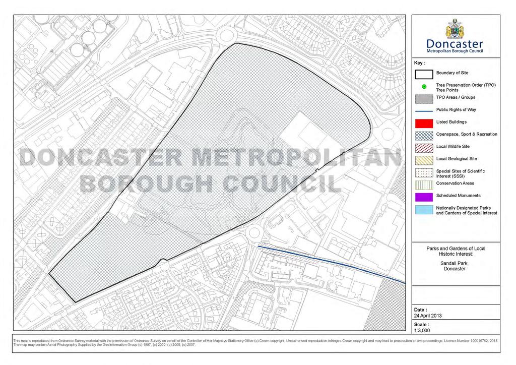
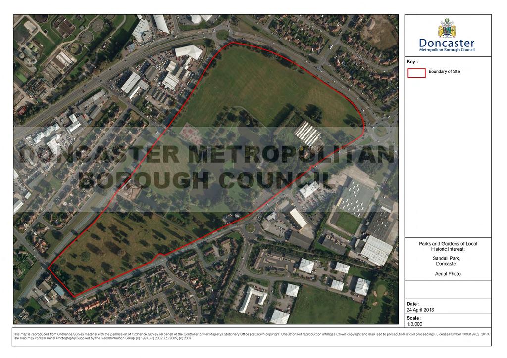
Sandall Park, Doncaster
|
|
|
- Darleen Greene
- 6 years ago
- Views:
Transcription
1 Sandall Park, Doncaster History The site was marked as the Sandall Brick and Tile Works on the 1854 and 1892 OS maps. It appeared on the 1906, 1930 and :2500 maps similarly marked but also disused. On 20 May 1938 a Ministry of Health Inquiry was held at the Mansion House about works proposed at the Sandall brickyards, a site of acres. There was a budget of 4,000. The successful tender for the lake works was won by Frank Haslam who quoted 3,033. The contract was to re-form the various pools, some up to 10 ft deep, into a single boating lake 4 ft deep. Doncaster Gazette Tenders were also invited for the construction of a boathouse and public conveniences. The boathouse tender price was 975. Doncaster Gazette The Ministry of Health gave the go-ahead for the work. Doncaster Gazette Work started on site. Doncaster Gazette carried photos of the existing pools being pumped dry to allow formation works to begin. In 1940, although war had broken out, the lake was opened as a park The 1960 OS map shows Sandall Park, the Boating Lake, the Boat House and the Landing Stage. Description The park comprises open space around a large lake, a number of recreational facilities and trees. The most significant feature is the lake. Significance The park is an example of an urban park with strong social links. It includes important park features including the lake, and original layout, planting beds and informal tree planting. However, it is not currently considered to be of sufficient significance to be a park and garden of local historic interest although if additional information does become available it may make this worth re-examining.


2 The boathouse in use probably in the 1950s The tower and flagpole of the boathouse. The flat-roofed building to the right is thought to probably be the public conveniences The disused boat house with all of its openings bricked up, prior to demolition Photos from the Friends of Sandall Park website and Google Images.
3
4
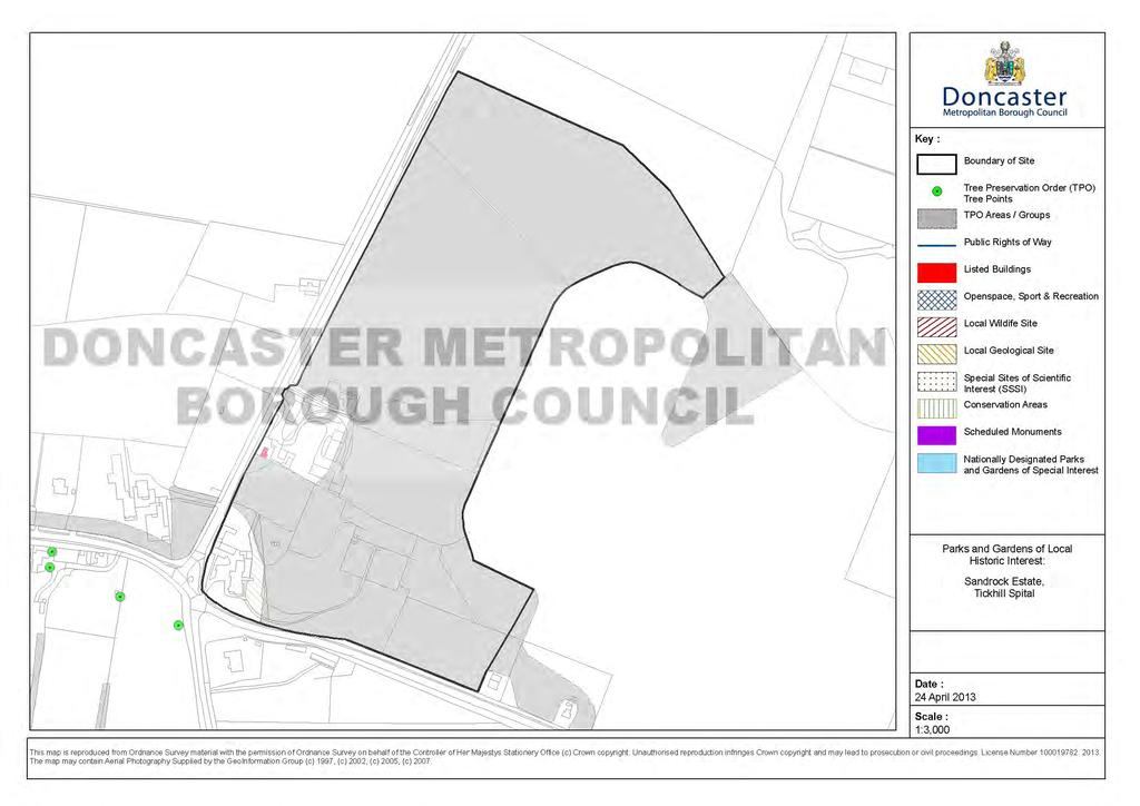
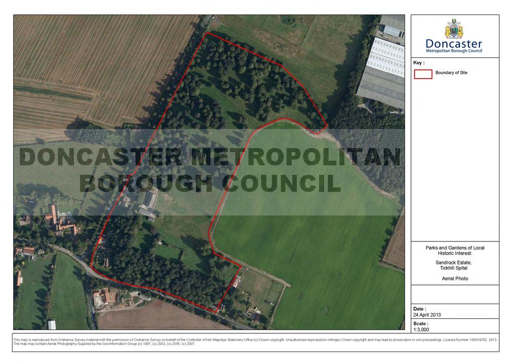
5 Sandrock Estate, Tickhill Spital History The Park seems to have been amalgamated into the grounds of Sandrock House a Late Victorian/Early Edwardian Manse home to Benjamin Heywood Brooksband JP (c.1870 to 1915). The grounds formerly included farm cottages (one of which is now a Grade II listed building) as well as other farm buildings (although these seem to now be independent of The Park) and previously a windmill. Description The grounds include dense planting along Bawtry Road which at its eastern end includes former Game Keeper s dwelling(s). To the north and adjacent to the Rossington Road there are extensive parkland with informal planting of individual trees and clumps. The parkland was originally much more extensive and included kennels and a pheasantry and was clearly a shooting estate. From historic maps this seems to have declined after the Second World War but still retains some of its previous character. Significance The grounds make up the wider (original) grounds of Sandrock House and incorporates important garden features including the listed cottage and woodlands. However, it is not currently considered to be of sufficient significance to be a park and garden of local historic interest although if additional information does become available it may make this worth reexamining.
6
7
8 Skellow Grange Grounds (now known as Burghwallis Grange), Skellow History The site was originally called Newsome Grange, owned in 1707 by Darcy Rawson of Bentley. It passed into the ownership of George Smyth and his family between 1741 and 1760, and was then conveyed several times until it was eventually sold to Godfrey Higgins Esq. in 1770 (Hunter 1831). Higgins also purchased the Manor of Skellow (a small 17 th century house in the village) and land surrounding Skellow Grange from George Anne Esq. of Burghwallis (Gordon Smith 1966/Klemperer 2010). Higgins (ob.1794) built himself a new mansion on the site in the 1770s which become known as Skellow Grange. The Higgins family lived here until the 19 th century. Since then it has been owned by a variety of people (Klemperer 2010). The house was demolished c when it was replaced with a modern dwelling. Description Skellow Grange (now Burghwallis Grange) lies on the Magnesian Limestone dip-slope. The 18 th century Skellow Grange built by Godfrey Higgins was a two storey, five-bay, stuccoed house, with two bay wings and Roman Doric columns around the central door (Klemperer 2010). A new house now occupies the site. Higgins also made a landscape park to the south and west and a fine sheet of water in the front of his house (Miller 1804). In addition Skellow Grange, set on a terrace above the parkland, had formal gardens and a pond to the east, and walled kitchen gardens, along with an orchard to the north east (Klemperer 2010). In the later 19 th century, contemporary photographs show a small conservatory on the side of the house, a gothic summerhouse/gazebo, classical statuary and a small parterre/knot garden centred on a classical statue in the gardens (Tuffrey 2000). The site was bordered with shelter belts, and the carriage drive, passing by the lake formed by the mill dam, had a lodge to protect its entrance (Klemperer 2010). The estate lodge, avenues of trees, plantations, parkland with tree clumps, terracing, and some 19 th century ornamental planting are still in evidence (Klemperer 2010) however it has been re-landscaped in the latter half of the 20 th century, including the reformation of the large lake. The gazebo and a knot garden are also understood to no longer remain. Significance The grounds make up the wider setting of the demolished Skellow Grange and incorporates important garden features including the lodge and woodlands/tree planting but much has recently been re-landscaped, although seemingly on similar lines to the original.


9 Whilst the previous parkland and its layout is still apparent, given the doubtful nature of how the recent landscaping compares with its original form it is not currently considered to be of sufficient significance to be a park and garden of local historic interest although if additional information does become available it may make this worth re-examining. Sketch map of 'Skellow Grange' based on a map drawn by Joseph Colbeck in 1763 which shows the property of William Turber Esq. Ordnance Survey First Edition 1854

10 Old photographs of Skellow Grange (now demolished)
11
12
.")
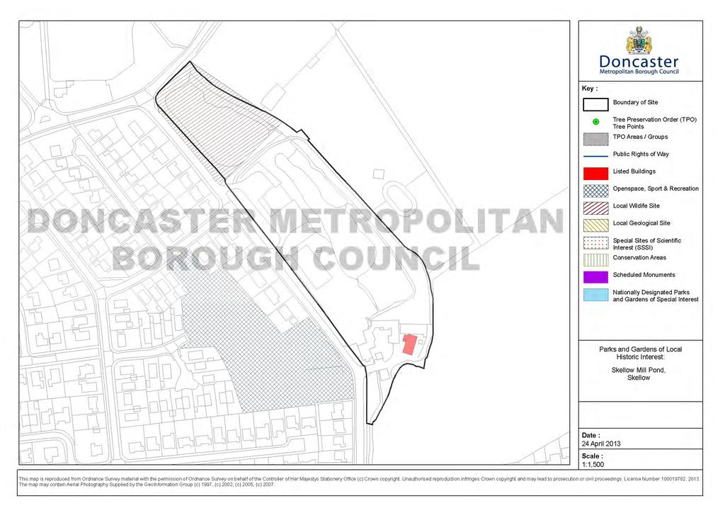
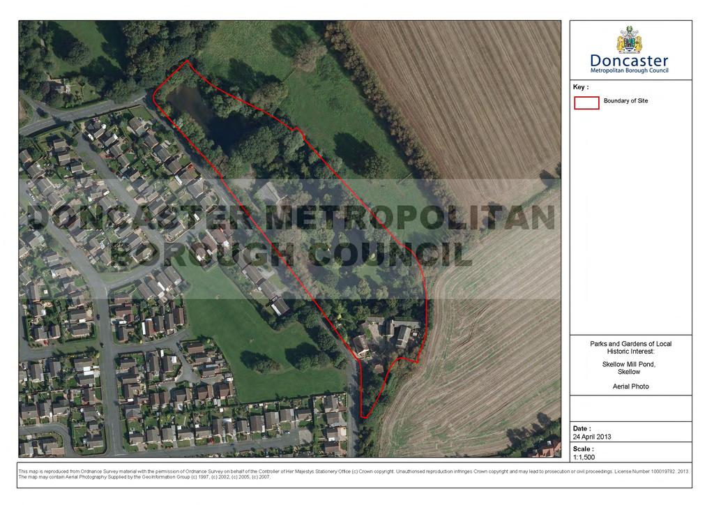
13 Skellow Mill Pond, Skellow History The existing water mill dates from c1800 and is of three storeys, in limestone rubble with stone slate roof. It is Grade II listed. Description The area makes up the grounds of the mill and includes ponds and mill race. The northern pond with its weir is shown in early maps ( ). The southern pond appears in later maps ( ). The grounds are well treed around the edge. Significance The grounds make up the wider setting of the listed mill and incorporates important landscape features including the mill run and its ponds and tree planting. It is however not considered to be of sufficient significance to be a park and garden of local historic interest but is important to the setting of the mill. Ordnance Survey First Edition 1854
14
15
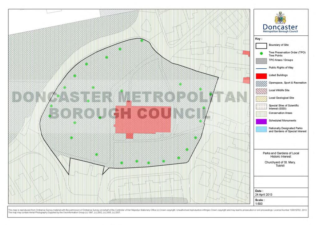
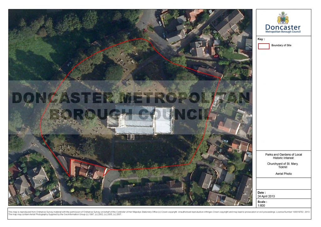
16 St. Mary s Churchyard, Tickhill History The church may possibly be built on the site of a Domesday Chapel, although it could also have started as a chapel/church to the castle that was transferred to the village. The earliest surviving material is the lower stage of the tower, which is of early 13th century date, the northeast chapel is of early 14th century date and the rest of the building was probably built not long after. The church is built of Magnesian limestone. It is grade I listed and lies within Tickhill Conservation Area. The churchyard was expanded in 1867 when the lane around the churchyard was diverted to form New Road. Description The churchyard is bounded by stone walls and fringed with lime trees with the church dominant in its centre, with a few specimen trees within the grounds. The churchyard is generally densely packed, although the area around the war memorial is open which is situated close to the principle entrance to the north. This area of the churchyard also has the most elaborate graves. Significance The church yard makes up the immediate setting of the Listed church and incorporates important features including the stone walls, monuments and grave stones and trees. It is also an important space in the Tickhill Conservation Area. It is however not considered to be of sufficient significance to be a park and garden of local historic interest but is important to the setting of the church and the conservation area.
17
18
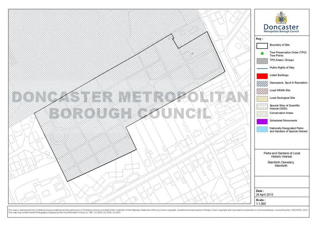
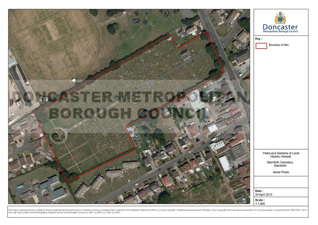
19 Stainforth Cemetery, Stainforth History The oldest record book for the cemetery is dated January 1st 1886 and lists each burial at the cemetery since that date. It is thought that the cemetery's first "occupants" were moved from another cemetery which was situated on a small area of land in the Thorne Road - Briars Lane area ( The War Memorial was erected c and sculptured by Tyas and Guest of Swinton. The cemetery is principally for the burial of Stainforth s former residents. Description Rectangular in shape with long (roughly) east-west axis (site has annexe on south side to back of site). Mortuary chapel to eastern end of site near to entrance. In front of mortuary chapel is war memorial. Several mature tress on frontage. Regular/orthogonal arrangement of paths and graves with little planting within apart from circular garden feature at end of central pathway. Oldest graves nearest to front with currently empty plots to rear. Significance The cemetery makes up the immediate setting of the mortuary chapel, with the listed war memorial in front and incorporates important features including the monuments, grave stones and trees. It is however not therefore considered to be of sufficient significance to be a park and garden of local historic interest but is an important community facility.
20
21
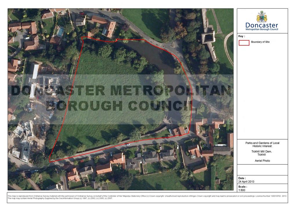
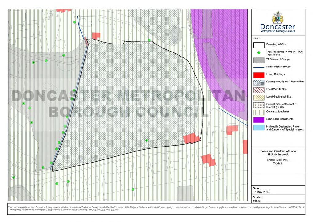
22 Tickhill Mill Dam, Tickhill History The mill is doubtless a site of antiquity but the present building dates from 18 th and 19 th century. The mill dam also feeds the moat of the neighbouring castle. Description The mill pond is the most conspicuous feature and with the stream that enters and exits the ponds encloses a meadow, both features being fringed with trees. The mill pond provides a setting for the mill as well as the castle, church and Rowland Bridge House. Significance The mill dam makes up the setting of the Listed mill (Grade II), castle (scheduled monument and Grade II*) and church (Grade I), and incorporates important landscape features including the pond, mill race, stream, grade II listed clapper bridge, stone walls and trees. It is also an important space in the Tickhill Conservation Area. It is however not considered to be of sufficient significance to be a park and garden of local historic interest but is important in the setting of several listed buildings, scheduled monument and the conservation area.
23
24
Lincoln Townscape Assessment. Boultham Park Inherited Character Area Statement
 Lincoln Townscape Assessment Boultham Park Inherited Character Area Statement January 2008 Page 2 of 12 Table of Contents Page Overview 2 Historical Development 2 Urban form 3 Views 5 Condition of Buildings
DACORUM GOLDEN PARSONAGE Great Gaddesden Brief Description Principal Building: Approach: Stable block other utilitarian buildings: Walled Garden:
 HERTFORDSHIRE GARDENS TRUST LOCAL LIST: DACORUM Present Name of Site GOLDEN PARSONAGE Historic Name (if known) Parish/Town Great Gaddesden National Grid Reference of Principal Building: TL051 125 Present
National Character Area 70 Melbourne Parklands
 Summary The are a landscape of rolling farmland, parkland and woodland on the northern flanks of the ridge between Burton upon Trent and Swadlincote. The land slopes down to the River Trent, which borders
SITE VISIT OFFICE MEETING TELEPHONE NOTES
 SITE VISIT OFFICE MEETING TELEPHONE NOTES Our Reference: Assigned to HB12 15 012 Date of meeting and site visit: 03/11/2016 Present: Edith Logue: HM Development and Change Branch Terence Reeves Smyth:
WELCOME TO THE NEW WILTON PARK
 WELCOME TO THE NEW WILTON PARK VISION HISTORY OF WILTON PARK TOWARDS A PLANNING APPLICATION Our objective is to create a truly outstanding environment at Wilton Park. At the heart of our proposals is a
Lancaster Conservation Area Appraisal. Character Area 8. Cathedral
 Lancaster Conservation Area Appraisal Character Area 8. Cathedral March 2013 118 3.8 Character Area 8. Cathedral 3.8.1. Definition of Special Interest "This character area is distinctive for the fine group
duncan heather & Associates GREYSTONE COLMORE LANE KINGWOOD OXON RG9 5NA
 duncan heather & Associates GREYSTONE COLMORE LANE KINGWOOD OXON RG9 5NA t:+44 (0)1491 628972 e: info@garden-design.org w: www.garden-design.org Feasibility Study For: Mr & Mrs David Yates The New House
7.1 Area 1: Haslemere Conservation Area
 7.1 Area 1: Haslemere Conservation Area Detailed map of Haslemere Town Conservation Area as of 2006 Crown copyright and database right 2011 Ordnance Survey LA100025451 27 The Conservation Area is characterised
Appraisal of proposed alterations to the boundary of Helmsley Conservation Area
 Appraisal of proposed alterations to the boundary of Helmsley Conservation Area Elmslac Road: Elmslac Road was constructed in the early 1950s in two or three stages by the Helmsley Rural District Council.
Historic England Advice Report 26 August 2016
 Case Name: Kingsland Castle Case Number: 1435892 Background Historic England has been asked to review the scheduling for Kingsland Castle. The land on which the monument lies is understood to be for sale.
2bPlanning Scheme. Appendix. Conservation - Removal of Structures. Grangegorman
 Appendix 2bPlanning Scheme Grangegorman Conservation - Removal of Structures Innovative Urban Quarter Contemporary Healthcare Facilities Modern Education Hub Accessible Public Spaces Appendix 2b: Purpose
Stanwick Neighbourhood Plan
 Stanwick Neighbourhood Plan Heritage Audit Stanwick Neighbourhood Plan Steering Group August 2015 Purpose of the Heritage Audit It is a core planning principle within National Planning Policy Framework
Gazetteer of Non-Designated Heritage Assets in Cressing Parish
 Gazetteer of Non-Designated Heritage Assets in Cressing Parish 1 Rainbow House, Polecat Lane, Cressing. Appears on the OS map for 1875. Included in the Conservation Appraisal as a Building of Townscape
The Park, Adwick-le-Street
 The Park, Adwick-le-Street History Originally forming the grounds of Adwick Hall, the family home of the Washington family. The hall was built in 1673 for Richard Washington and was a vernacular building
Badgers Hurst, Near Petersfield, Hampshire GU31 5RF
 Badgers Hurst, Near Petersfield, Hampshire GU31 5RF Badgers, Hurst, Near Petersfield, Hampshire GU31 5RF A charming period farmhouse of great character, together with a separate single storey cottage,
INTRODUCTION. Land West of Main Road, Stanton Harcourt THE SITE. Why is the Site Suitable for Development?
 0 INTRODUCTION THE SITE Application Boundary Gladman Developments Ltd has successfully invested in communities throughout the UK over the past 0 years, developing high quality and sustainable residential,
Alresford Grange. a l r e s f o r d n c o lc h e s t e r n e s s e x
 Alresford Grange a l r e s f o r d n c o lc h e s t e r n e s s e x 1 2 Alresford Grange a l r e s f o r d n c o l c h e s t e r n e s s e x Superbly positioned Edwardian country house with exceptional
U p p e r L a n g d a l e s F a r m h o u s e C R E E T I N G S T M A R Y 8 S U F F O L K
 U p p e r L a n g d a l e s F a r m h o u s e C R E E T I N G S T M A R Y 8 S U F F O L K Upper Langdales Farmhouse Creeting St Mary, Suffolk, IP6 8QF R E S T O R E D P E R I O D F A R M H O U S E I N
Stowey Sutton Parish Council. Stowey Sutton Parish Council Placemaking Plan Assets of Community Value June 2014
 Stowey Sutton Parish Council Placemaking Plan Assets of Community Value June 2014 1 2 Contents Identifying natural & built environment assets... 5 Natural & built environment asset: Lovell Mill... 7 Natural
The Miller s House. Rode Hill, Rode, Somerset, BA11 6PS
 The Miller s House Rode Hill, Rode, Somerset, BA11 6PS The Miller s House Rode Hill, Rode, Somerset, BA11 6PS A beautiful Grade II* listed Queen Anne former dye house set in over 2 acres Entrance Hall,
Nucleated Rural Settlements Zone
 Nucleated Rural Settlements Zone Each character area within this zone, equating to an individual settlement core, has been described and mapped separately in the Nucleated Settlement Gazetteer. As a result,
East Riding Historic Designed Landscapes. 1.3 Administrative area: Bridlington Civil Parish, East Riding of Yorkshire Unitary Authority
 YORKSHIRE GARDENS TRUST East Riding Historic Designed Landscapes SEWERBY HALL Report by David and Susan Neave May 2013 1. CORE DATA 1.1 Name of site: Sewerby Hall, Sewerby 1.2 Grid reference: TA 203691
DISTINCTION IN BUILDING AWARDS 2016
 DISTINCTION IN BUILDING AWARDS 2016 The award scheme was introduced in 1992 with the aims of encouraging high standards of design and workmanship in developments in Worthing, and giving public recognition
Appendix 1: Site Inventory Form
 Appendix 1: Site Inventory Form Wapsi Valley Archaeology, Inc. Anamosa, IA 56 X Cemetery Washington 83 24 2 NE X 1 5 approx. 200 approx. 201 unknown unknown Historic Resources Evaluation: 07A: Cemetery
Case Studies; Meitheal Clusters Applied to Villages and Rural Settlements
 Case Studies; Meitheal Clusters Applied to Villages and Rural Settlements 23.3.9 (ii) Case Studies, Meitheal Clusters applied to villages and rural settlments Fig 22.3.12 Cluster site plan; church opposite
GARDENS AND ESTATES HORTON COUNTRY HOUSE LONGCROSS ESTATE LA GRANDE MAISON SUDELEY LAWN BARN NEAR BRIXWORTH WINGROVE HOUSE
 Our garden and estate work encompasses both traditional and contemporary design, informed by our skills in historic landscape conservation, and has been consistently well received. We like to work closely
MEDLANDS FARM Combe Lane, Shere, Guildford, Surrey
 MEDLANDS FARM Combe Lane, Shere, Guildford, Surrey MEDLANDS FARM Combe Lane, Shere Guildford, Surrey GU5 9TD SHERE VILLAGE - 0.75 mile Guildford (Waterloo 38 mins) - 5 miles Set in 37 acres of pastureland
The analysis of key visual characteristics and attributes that contribute to variations in the
 15.0 CHIGWELL/CHIGWELL ROW 15.1 Overview 15.1.1 Chigwell and Chigwell Row settlements are situated in the south of Epping Forest District, to the south of Abridge and southwest of Stapleford Abbotts. Both
Neighbourhood Planning Guidance Local Green Spaces
 Neighbourhood Planning Guidance Local Green Spaces Introduction This guidance note has been produced for communities preparing neighbourhood plans in North Dorset to help them to identify, assess and designate
Ordnance Street 110 Plan OS Lot 413 B202; parts of Lot 412 and portion of Lot 413
 Ordnance Street 110 Plan OS Lot 413 B202; parts of Lot 412 and portion of Lot 413 110 Ordnance Street has cultural heritage value under 3 categories Physical built in 1886, it is an example of late 19
Warwickshire County Council. Upper and Lower Brailes. Landscape Study
 Warwickshire County Council Upper and Lower Brailes Landscape Study Produced by WCC Landscape Architects March 2016 Landscape Assessment of Potential Development Sites within the parish of Brailes 1.0
THE CITY OF LAKE FOREST HISTORIC PRESERVATION COMMISSION LOCAL LANDMARK NOMINATION INSTRUCTIONS
 THE CITY OF LAKE FOREST HISTORIC PRESERVATION COMMISSION LOCAL LANDMARK NOMINATION INSTRUCTIONS This application is for the nomination of individual properties as Local Historic Landmarks within the City
NATIONAL REGISTER OF HISTORIC PLACES MULTIPLE PROPERTY DOCUMENTATION FORM CONTINUATION SHEET ASSOCIATED PROPERTY TYPES
 Section F, Page 1 ASSOCIATED PROPERTY TYPES Six common property types are identified with the 48 cemeteries surveyed in the Town of Southampton. These six property types are identified as being associated
Houses on the Forest Edge
 Houses on the Forest Edge Vivien Hill 1 Contents 3 Introduction 4 Pavilion Cottages 5 Oak Tree Cottage 6 Arts and Crafts Style 7 Laura House 8 Hillview 9 Bryle House 10 William Wells and the 1851 Census
CITY OF MIAMI CEMETERY 1800 N.E. 2 AVENUE
 CITY OF MIAMI CEMETERY 1800 N.E. 2 AVENUE Designation Report City of Miami REPORT OF THE CITY OF MIAMI PLANNING DEPARTMENT TO THE HERITAGE CONSERVATION BOARD ON THE POTENTIAL DESIGNATION OF CITY OF MIAMI
History of the Cranley Road Area. What is The Cranley Road Area
 History of the Cranley Road Area. What is The Cranley Road Area The Cranley Road Area lies to the east of Guildford. It was originally developed as large Victorian villas by the 4 th Earl of Onslow. It
The Mill House Isfield, East Sussex
 The Mill House Isfield, East Sussex An impressive and well-appointed Grade II listed country house set in beautiful grounds of 4.904 acres, with a cottage, tennis court, swimming pool and Sussex Barn.
Introduction. Welcome to this consultation regarding the draft redevelopment proposals for the former CeramTec factory on Sidmouth Road, Colyton.
 Introduction Welcome to this consultation regarding the draft redevelopment proposals for the former CeramTec factory on Sidmouth Road, Colyton. We are currently considering options for the mixed-use redevelopment
ENVIRONMENTAL INVENTORY
 Hungarton Neighbourhood Plan ENVIRONMENTAL INVENTORY Sites scoring 25/36 or more (70%) are judged to be the most important environmental and community sites and are proposed as Local Green Space. Other
Persimmon Homes Thames Valley Date received: 2 nd April week date(major): 2 nd July 2014 Ward: Nascot
: 2 nd July 2014 Ward: Nascot") PART A Report of: DEVELOPMENT MANAGEMENT SECTION HEAD Date of Committee: 26 th June 2014 Site address: Rounton, 28, Nascot Wood Road Reference Number: 14/00497/REM Description of Development: Reserved
PART A Report of: DEVELOPMENT MANAGEMENT SECTION HEAD Date of Committee: 26 th June 2014 Site address: Rounton, 28, Nascot Wood Road Reference Number: 14/00497/REM Description of Development: Reserved
Environmental and Landscape Mapping
 Environmental and Landscape Mapping In support of the Calveley Neighbourhood Plan November 2016 Project Name and Number: Calveley Neighbourhood Plan 16-025 Document Name and Revision: Environmental and
Built in 1984, the meeting house is the third meeting house on a site acquired in 1668 as a burial ground. The building has low heritage significance.
 Friends Meeting House, Reigate 47 Reigate Road, Reigate, Surrey, RH2 0QT National Grid Reference: TQ 26184 50219 Statement of Significance Built in 1984, the meeting house is the third meeting house on
Doncaster Christ Church Conservation Area
 Doncaster Christ Church Conservation Area Review June 2017 www.doncaster.gov.uk/conservationareas Doncaster Christ Church Conservation Area Review Since the appraisal was finalised in February 2011, the
Sunday's Well Proposed Architectural Conservation Area
 1 Sunday's Well Proposed Architectural Conservation Area D A E C B F Old City Gaol Saint Vincent s RC Church Saint Albert s Former Good Shepherd Convent Boundary of Area Sunday's Well is an area located
BORRISOKANE SETTLEMENT PLAN
 BORRISOKANE SETTLEMENT PLAN 1.0 General Introduction and Development Context Location Borrisokane is located 15km north of Nenagh on the N52. While the town is primarily residential, it acts as a market
Groby Pool and Bradgate Park. Circular walks around Leicestershire. Lin and John
 Groby Pool and Bradgate Park Bradgate House Lin and John A circular walk from Groby Pool via Anstey Village, Bradgate Park and Newtown Linford Village. Duration - 2 ½ to hours 3½ hours Distance - 9¼ kilometres
Character Area 1: Town Core
 Character Area 1: Town Core Map S 354 Copyright Cotswold District Council 109 Character Area 1: Town Core Key Characteristics 355 356 357 358 359 360 361 362 363 364 365 366 367 368 369 370 Copyright Cotswold
Parish Derry Slopes ITM Coordinates ; NG Coordinates C House B1 and farm buildings B2; Registered Garden L061
 Asset Ref No. HB/01/27/018A-C, Ballyarnett & Farm; Registered Historic Garden L061 Heritage Type Location Protection Status Condition Ownership (if known) Built Post-Medieval house & farm OS 6-inch map
ENVIRONMENTAL AND LANDSCAPE MAPPING
 APPENDIX IV : Environmental and Landscape Mapping ENVIRONMENTAL AND LANDSCAPE MAPPING Calveley Neighbourhood Plan November 2016 ENVIRONMENTAL AND LANDSCAPE MAPPING Calveley Neighbourhood Plan Calveley
5.1 INTRODUCTION 5.2 EXISTING CONDITIONS
 Chapter 5: Aesthetic Resources 5.1 INTRODUCTION This chapter considers the potential of the Proposed Action to impact the visual character and aesthetic resources of the project area and the surrounding
Clifton Mill. Clifton Oxfordshire
 Clifton Mill Clifton Oxfordshire Clifton Mill Clifton Oxfordshire Approximate distances: Banbury 8 miles (London Marylebone by rail from 55 minutes) Bicester 11 miles (London Marylebone from 40 minutes)
CGT visit to Godolphin 11 th May 2016
 CGT visit to Godolphin 11 th May 2016 The garden at Godolphin Is one of Cornwall s most important medieval gardens and is on the national Register of Parks and Gardens as II*. The Register summary states
STRENSALL RAILWAY BUILDINGS CONSERVATION AREA APPRAISAL. In association with Strensall with Towthorpe Parish Council
 STRENSALL RAILWAY BUILDINGS CONSERVATION AREA APPRAISAL In association with Strensall with Towthorpe Parish Council CONTENTS Page 1 Introduction 2 2 Location and Context 3 3 Topography and Setting 4 4
Evidential value The meeting house site is likely to have low archaeological potential and the building has low evidential value.
 Friends Meeting House, Colwyn Bay 21 Erskine Road, Colwyn Bay, LL29 8EU National Grid Reference: SH 85406 78739 Statement of Significance The 1899 meeting house is an attractive late Victorian building
Toddington Central Bedfordshire Stage 3 Green Belt Study December 2017
 Toddington Central Bedfordshire Stage 3 Green Belt Study December 2017 Site: ALP086 - Middle Lakes, Toddington Site size (ha): 2.83 Site: ALP086 - Middle Lakes, Toddington Site size (ha): 2.83 Site description
Moor Hall Stoke by Clare, Suffolk
 Moor Hall Stoke by Clare, Suffolk Moor Hall, Stoke by Clare, Sudbury, Suffolk CO10 8HJ Stoke by Clare is a pretty and highly regarded village. Picturesque cottages and houses surround the village green
CLAYTON PRIORY London Road Hassocks West Sussex BN6 9NE
 CLAYTON PRIORY London Road Hassocks West Sussex BN6 9NE CLAYTON PRIORY Clayton Priory is Listed Grade II*, being of particularly important 'historic and architectural interest', and is a superb example
6. Bermondsey 6.1. Bermondsey Area Vision
 6. 6.1. Area Vision 6.1.1. is: An inner-london neighbourhood characterised by modest worker ho associated with the historic Rotherhithe docks and local manufacturing industries such as biscuits, jam, vinegar
Friends Meeting House, Broughton. Meeting House Lane, Little Broughton, Cockermouth, CA13 0YQ. National Grid Reference: NY
 Friends Meeting House, Broughton Meeting House Lane, Little Broughton, Cockermouth, CA13 0YQ National Grid Reference: NY 07832 31740 Statement of Significance The modest building has medium significance
CHESHIRE HISTORIC TOWNS SURVEY
 CHESHIRE HISTORIC TOWNS SURVEY Frodsham Archaeological Strategy 2003 CHESHIRE HISTORIC TOWNS SURVEY Frodsham Archaeological Strategy 2003 Environmental Planning Cheshire County Council Backford Hall Backford
INTRODUCTION CURRENT APPLICATION
 05/01805/FUL & 05/01807/LBC ERECTION OF A SINGLE DWELLING HOUSE WITH ANCILLARY ACCOMMODATION AT Flamingo Zoological Gardens, Olney Road, Weston Underwood FOR Mr A J Crowther (as amended by letter dated
East Harptree Landscape & Character Assessment
 East Harptree Landscape & Character Assessment Produced by East Harptree Parish Council in consultation with local residents September 2014 Contents The Parish of East Harptree: Objective Introduction
New Swimming Pool,West Meon House, West Meon, Hampshire
 New Swimming Pool,West Meon House, West Meon, Hampshire An Archaeological watching brief and building recording for Mr and Mrs Younger by Danielle Milbank Thames Valley Archaeological Services Ltd Site
Paynes Farm Uplowman, Tiverton, Devon
 Paynes Farm Uplowman, Tiverton, Devon Paynes Farm Uplowman, Tiverton, Devon, EX16 7LY Tiverton about 5 miles Wellington about 15 miles Taunton about 19 miles Exeter about 22 miles (Distances are approximate)
DESIGN & ACCESS STATEMENT
 . DESIGN & ACCESS STATEMENT Site Adjacent to The Manor House, Upper Street,, Kingsdown, Deal, Kent. DESIGNS ARCHITECTURE + PLANNING CONTENTS Design and Access Statement Introduction Site and Location Planning
DESIGN AND ACCESS STATEMENT LAND AT UNDERCLIFF, CLEADON LANE PROPOSED PROVISION OF PERMANENTLY SITED STABLE BLOCK AND GRASSED PADDOCK AREA
 DESIGN AND ACCESS STATEMENT LAND AT UNDERCLIFF, CLEADON LANE PROPOSED PROVISION OF PERMANENTLY SITED STABLE BLOCK AND GRASSED PADDOCK AREA 1.0 APPLICATION This application is for full planning permission
Urban Design Brief Woodland Cemetery Funeral Home 493 Springbank Drive
 Urban Design Brief Woodland Cemetery Funeral Home The Incorporated Synod of the Diocese of Huron April 15, 2016 Urban Design Brief April 15, 2016 TABLE OF CONTENTS Page No. INTRODUCTION... 1 SECTION 1
Capability Brown at Sherborne Castle
 Capability Brown at Castle Capability Brown s lake Castle Estates From 1753 Capability Brown landscaped the grounds at in two phases, creating the beautiful lake that dominates the park and later remodelling
Misterton Neighbourhood Plan
 Misterton Neighbourhood Plan Neighbourhood Profile Neighbourhood Character Profile TABLE OF CONTENTS 1. Introduction... 3 2. How to use this Report... 4 3. Neighbourhood Profiles: Zone 1... 6 4. Neighbourhood
List of Buildings of Local Architectural or Historic Interest BUCKHURST HILL PARISH
 List of Buildings of Local Architectural or Historic Interest BUCKHURST HILL PARISH 1. ST. STEPHEN'S CHURCH Albert Road /Buckhurst Way Attractive, albeit modest, late 19th century church (date stone 1876)
Understanding Historic Parks and Gardens in Buckinghamshire
 Understanding Historic Parks and Gardens in Buckinghamshire The Buckinghamshire Gardens Trust Research & Recording Project Denham Grove (formerly Durdent Court/ Tile House) April 2016 Bucks Gardens Trust
Stapleford Grange STAPLEFORD ; CAMBRIDGESHIRE
 Stapleford Grange STAPLEFORD ; CAMBRIDGESHIRE Stapleford Grange stapleford ; CAMBRIDGESHIRE Shelford 0.9 mile Cambridge city centre 4 miles (London Liverpool Street 70 mins/kings Cross 50 mins) Newmarket
Greenfields Farm WYCK RISSINGTON GLOUCESTERSHIRE
 Greenfields Farm WYCK RISSINGTON GLOUCESTERSHIRE Greenfields Farm WYCK RISSINGTON GLOUCESTERSHIRE A 5 bedroom Cotswold stone house sitting in a private edge of village setting with woodland and a paddock
STRATFIELD SAYE HAMPSHIRE
 The Well House STRATFIELD SAYE HAMPSHIRE The Well House STRATFIELD SAYE HAMPSHIRE A charming Grade II listed country house set in stunning gardens in an attractive rural setting. Accommodation and amenities
Lincoln Townscape Assessment. Sherbrooke Inherited Character Area Statement
 Lincoln Townscape Assessment Sherbrooke Inherited Character Area Statement June 2008 Page 2 of 15 Table of Contents Page Overview 2 Historical Development 3 Urban form 4 Views 8 Condition of Buildings
Butler s Farm, St Mary Bourne, Hampshire
 Butler s Farm, St Mary Bourne, Hampshire On the market for the first time in 47 years Lying on a quiet country lane, a 17th century Grade II listed farmhouse, beautifully maintained, with a magnificent
HERITAGE REPORT: REASONS FOR HERITAGE DESIGNATION. 62 Union Street. Prepared By:
 L 3-1 1 Brampton Heritage Board Date: January 18, 2011 HERITAGE REPORT: REASONS FOR HERITAGE DESIGNATION 62 Union Street Prepared By: Prepared by: Antonietta Minichillo, Heritage Coordinator Planning,
Stowford Mill, Ivybridge Introduction
 Stowford Mill, Ivybridge Introduction 1. What is the purpose of this exhibition? Burrington Estates would like residents and interested parties to have the opportunity to review updated proposals for the
Conservation Area Designation, amendments and Review
 Conservation Area Designation, amendments and Review Location: Any area largely confined to Park Road and St. James Avenue which includes the following properties: St. James Church, St. James Road; No.
Exploring Abergavenny
 11 Majors Barn36 Ysguborwen Exploring Abergavenny 2 ysguborwen EXPLORING ABERGAVENNY For several years the Abergavenny and District Civic Society has been studying the streets, spaces and buildings of
New Homes at Winton East
 View toward Winton East from Caerketton Hill Aerial photograph of South Edinburgh: Winton East Site Location Indicative proposal Welcome Thank you for coming to the Winton East public exhibition. We would
WELCOME. Olney Road, Lavendon INTRODUCTION. The Site. The Application. The Need for Housing. A Sustainable Location LAVENDON TURVEY OLNEY ROAD
 0 WELCOME INTRODUCTION Gladman Developments Ltd have successfully invested in communities throughout the UK over the past 0 years, developing high quality and sustainable residential, commercial and industrial
CALA HO ME S WELCOME
 WELCOME Welcome to this public consultation event for our proposed residential development of 56 high quality homes on land to the north east of Station Road in Earls Colne. Thank you for taking the time
WOOLMERS MANNINGS HEATH WEST SUSSEX
 WOOLMERS MANNINGS HEATH WEST SUSSEX WOOLMERS MANNINGS HEATH WEST SUSSEX A wonderful property which originates back to 1590, not listed and assembled in beautiful grounds including lakes, parkland and
Chiswick High Road, Chiswick, London W4 5TF [00248/ /P1; P/2014/3288]
![Chiswick High Road, Chiswick, London W4 5TF [00248/ /P1; P/2014/3288]](/thumbs/75/72156720.jpg "Chiswick High Road, Chiswick, London W4 5TF [00248/ /P1; P/2014/3288]") 1 408-430 Chiswick High Road, Chiswick, London W4 5TF [00248/408-430/P1; P/2014/3288] Summary of Friends of Turnham Green's view Whilst Friends of Turnham Green are in principle open to sustainable development
1 408-430 Chiswick High Road, Chiswick, London W4 5TF [00248/408-430/P1; P/2014/3288] Summary of Friends of Turnham Green's view Whilst Friends of Turnham Green are in principle open to sustainable development
Berkeley House Boughton Hill, Dunkirk, Faversham, Kent ME13 9LE
 Berkeley House Boughton Hill, Dunkirk, Faversham, Kent ME13 9LE Berkeley House Boughton Hill, Dunkirk Faversham, Kent ME13 9LE 1,100,000 Guide Price Boughton 0.5 mile M2 1.8 miles Faversham Station 4.4
1 THE OLD VICARAGE MANOR ROAD F GORING ON THAMES F OXFORDSHIRE
 1 THE OLD VICARAGE MANOR ROAD F GORING ON THAMES F OXFORDSHIRE 1 THE OLD VICARAGE MANOR ROAD F GORING ON THAMES F OXFORDSHIRE Pangbourne on Thames 5 miles F Reading 10 miles F Newbury 13 miles F Oxford
THE OLD House FRENSHAM SURREY
 THE OLD House FRENSHAM SURREY THE OLD HOUSE FRENSHAM SURREY A beautifully presented Grade II listed country house with stunning gardens, situated on the edge of a highly sought after village and with
Highfield House. Wilton, Wiltshire
 Highfield House Wilton, Wiltshire Highfield House Wilton, Wiltshire A magnificent renovated Country House in about 5.4 acres of private grounds. Marlborough 8 miles, Great Bedwyn 2.6 miles with mainline
SANDPIT FARM BRUISYARD 8 SUFFOLK
 SANDPIT FARM BRUISYARD 8 SUFFOLK SANDPIT FARM Bruisyard, Suffolk GRADE II LISTED COUNTRY HOUSE OFF A QUIET COUNTRY LANE SURROUNDED BY UNDULATING COUNTRYSIDE WITH ATTRACTIVE GARDENS, STUDIO ANNEXE, TRADITIONAL
DRAFT/02. Our Place. Westbury-on-Trym. City Design Group. July 2013 City Design Group
 DRAFT/02 City Design Group Contents Preface 1. Introduction 2. Character and distinctiveness 3. Character Areas 1 Henbury Road environs 2 Commercial core 3 College and Church Road environs 4 Channell
East Riding Historic Designed Landscapes. Report by David and Susan Neave February 2013
 YORKSHIRE GARDENS TRUST East Riding Historic Designed Landscapes GRIMSTON GARTH Report by David and Susan Neave February 2013 1. CORE DATA 1.1 Name of site: Grimston Garth, East Garton 1.2 Grid reference:
Memo. B R A Y H e r i t a g e
 6 1 3. 5 4 2. 3 3 9 3 6 1 3. 5 4 9. 6 2 3 1 c a r l @ b r a y h e r i t a g e. c o m Memo To: Jennifer Murray, Windmill Development Corporation From: Carl Bray, Bray Heritage Date: Monday, June 5, 2017
DESIGN & ACCESS STATEMENT
 DESIGN & ACCESS STATEMENT January 2016 Contents Introduction section 1 Section 1 - Introduction Section 2 - Assessment Section 3 - Involvement Section 4 - Evaluation Section 5 - Design Section 6 - Layout
Cottage Grove. Conservation Area. Character Appraisal
 Positive People - Positive Leadership - Positive Partnerships Cottage Grove Conservation Area Character Appraisal Consideration of Proposal to Designate Grove Avenue and Park Road Chilwell as a Conservation
Key development locations along the route of the scheme are identified in Chapter 4.
 6 Land Use 6.1 Introduction This chapter describes the effects of the proposed Edinburgh Tram Line One on land uses, including property and community land along the route. In particular it: reviews the
Laurieston. Chedworth Gloucestershire
 Laurieston Chedworth Gloucestershire Laurieston Chedworth Gloucestershire A delightful family house with beautiful gardens in a desirable Cotswold village Entrance hall Cloakroom Sitting room Conservatory
Supplementary Heritage Appraisal Syon & Osterley Parks
 Supplementary Heritage Appraisal Syon & Osterley Parks February 2017 Prepared by Montagu Evans All Ordnance Survey Plans are Crown Copyright. All rights reserved. Licence Number: 100007624 Copyright 2017.
GREENSPACES MANAGEMENT
 GREENSPACES MANAGEMENT 3-year Strategy Routine Management & Improvement Plan covering the 25 sites owned and/or managed by Stroud Town Council. A three-year plan to run from financial year - 2013/14 THE
Conservation Area Designation, amendments and Review
 Conservation Area Designation, amendments and Review Location: No.s 37-49 (odd) Twickenham Road Date Assessed: January 2018 Adjacent Conservation Area Significance: Teddington Lock CA. The Teddington Lock