The Conservation Area Appraisal should be read in junction with the following documents or their successors:
|
|
|
- Curtis Floyd
- 5 years ago
- Views:
Transcription
1 (draft)( ) Character Appraisal May 2017 Nor rth Park Roa ad and Sou uth Park Road Con nservation Areas
2 MAY 2017 Foreword The Conservation Area Appraisal should be read in junction with the following documents or their successors: North Park Road and South Park Road Conservation Areas Management Plan (2017); The National Planning Policy Framework (2012); National Planning Practice Guidance; Knowsley Local Plan: Core Strategy (2016) including saved policies from the Knowsley Unitary Development Plan (2006); Adopted Supplementary Planning Guidance. The omission of mention of any building, site or feature should not be taken to imply that it is of no interest. This document has been written and prepared by Knowsley Metropolitan Borough Council. Planning Services, Knowsley Metropolitan Borough Council, Yorkon Building, Archway Road, Huyton, Knowsley Merseyside L36 9FB Telephone:
3 CONTENTS CONTENTS 1 INTRODUCTION North Park Road and South Park Road Conservation Areas Planning Policy Context LOCATION AND LANDSCAPE SETTING Location and Setting Topography and Geology HISTORICAL DEVELOPMENT AND ARCHAEOLOGY Historical Development Archaeology SPATIAL ANALYSIS Layout and Patterns of Development Open Spaces, Trees and Landscaping Focal Buildings and Views Public Realm ARCHITECTURE, DETAILS AND MATERIALS Building Age and Uses Architecture Building Materials and Details Listed Buildings Locally Listed Buildings SUMMARY OF KEY CHARACTERISTICS ISSUES AND OPPORTUNITIES FOR ENHANCEMENT Conservation Area Boundary Review Design of Development Alterations to Features Setting of Conservation Area Traffic and Pedestrian Movement Vacancy and Condition Enforcement Issues
4 MAY Article 4 Directions Opportunities for Enhancement REFERENCES APPENDIX APPENDIX APPENDIX APPENDIX APPENDIX APPENDIX APPENDIX APPENDIX

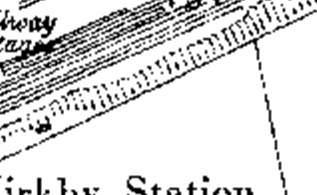
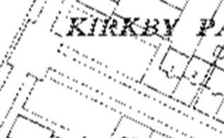
5 1 INTRODUCTION 1 INTRODUCTION 1.1 North Park Road and South Park Road Conservation Areas North Park Road and South Park Road exist as two separate conservation areas located in Kirkby, in the Metropolitan Borough of Knowsley. Kirkby is situated some eight miles North West of Huyton town centre and the conservation areas are easily accessible, being a short walk away from Kirkby Railway Station and close to the M57 and the A580, the Liverpool East Lancashire Road. The two conservation areas have a similar suburban character featuring residential houses from the 1860s onwards, with mature trees lining the roads. The properties in both conservation areas range from Victorian villas to modern 20 th century flats; these are generally set within well sized gardens with defined boundary treatments. Several of the older villas are listed at Grade II. Both North Park Road Conservation Area and South Park Road Conservation Area were designated on 21 st March Figure 1 Map showing the location of North Park Road and South Park Road Conservation Areas in the Liverpool City Region context, indicated by the blue star. 5
6 MAY Planning Policy Context Conservation areas are designated under Section 69 of the Planning (Listed Buildings and Conservation Areas) Act The overall definition of a Conservation Area is stated within the same Act as, an area of special architectural or historic interest, the character or appearance of which it is desirable to preserve or enhance. Section 71 of the Planning (Listed Buildings and Conservation Areas) Act 1990 makes it the duty of any Local Planning Authority to formulate and publish proposals for the preservation and enhancement of their conservation areas. Additionally, Section 72 specifies that in making a decision on an application for development within a conservation area, special attention must be paid to the desirability of preserving or enhancing the character or the appearance of that area. National government policy regarding conservation areas is set out within the National Planning Policy Framework (2012) (NPPF) supported by National Planning Practice Guidance (NPPG). Knowsley Council has also set out its local policy through the Local Plan Core Strategy (2016), particularly Policy CS20: Managing the Borough s Historic Environment and DQ5: Development in Conservation Areas which is a saved policy within the Unitary Development Plan (2006). In recognition of the statutory requirement stated within the Act and the policies of the NPPF, this appraisal identifies and assesses the special architectural and historic interest of the North Park Road and South Park Road Conservation Areas, in line with Historic England s Advice Note 1: Conservation Area Designation, Appraisal and Management. 6
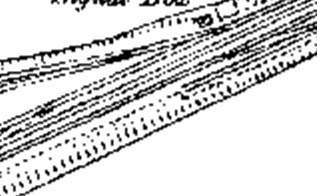
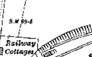
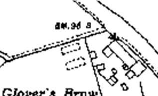
7 2 LOCATION AND LANDSCAPE SETTING 2 LOCATION AND LANDSCAPE SETTING 2.1 Location and Setting Traditionally part of Lancashire, Kirkby is an urban settlement located in the County of Merseyside, in the Borough of Knowsley. Kirkby is located approximately eight miles from Liverpool City Centre and lies within a mile of the M57. It has a railway station with good links to Liverpool and Manchester. The River Alt flows through the extreme south west of the town, with the Kirkby Brook tributary passing through the centre. The town of Huyton is located approximately eight miles South of Kirkby. The Conservation Areas are centred on the Kirkby Park residential area that was built to the North of Kirkby railway station concurrently with the introduction of the railway line, which is located North West of Kirkby Town Centre. North Park Road Conservation Area runs from the junction of Glover s Brow/ Mill Lane to Park Road. South Park Road Conservation Area runs from Glover s Brow to the junction of Sefton Close. The conservation areas run parallel to each other but are separated by the 1950s Park Estate development, connected only by Glovers Brow which runs perpendicular to the eastern entrances of the North Park Road and South Park Road conservation areas. The tree lined streets are characterised by several high status Victorian villas and early 20 th century semi-detached houses. Today the conservation areas are enclosed by post-war housing estates built to accommodate the planned relocation of population from Liverpool. Prior to this dramatic change, the surroundings of Kirkby Park were rural, with scattered farmsteads and isolated plantations. Some of the land had been reclaimed from flat peaty areas known as mosses and, indeed, Kirkby Moss and Simonswood Moss survive to this day, slightly to the east of the built up area. The countryside to the North of the conservation areas is designated as Green Belt extending along the M57 corridor North towards Melling and Simonswood. This designation has helped to preserve the landscape setting north of the conservation areas. North Park Road and South Park Road Conservation Areas lie at the convergence of a number of routes and the area can be accessed from several roads: Glovers Brow from the North and South; Kirkby Row from the South and Mill Lane from the east. The close proximity of the railway is an important setting to the conservation areas and is reminiscent of the area s development evolving with the introduction of the railway. 7

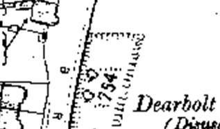
8 MAY 2017 Figure 2 Location of North Park Road and South Park Road in a wider area context. 2.2 Topography and Geology Kirkby lies upon a raised area of land elevated some feet above sea level. To the east the land rises further on the approach to the foothills of the Pennines. North Park Road and South Park Road Conservation Areas occupy relatively flat areas of the town with little undulation evident in the townscape. Much of Kirkby consists of stratified pebble beds dating from the Triassic period known as Bunter Sandstone, and this was used as building material in a number of the town s early buildings such as St Chad s Church, situated a short walk from the conservation areas. Up until the 1870s, the land to East of Glover s Brow just outside the conservation area was the site of an early 19 th century stone quarry, known as Dearbolt or Deerbough Delf. The quarry is no doubt the source of stone from which some of the buildings in the conservation area were built, adding to the buildings local character. 8
9 3 HISTORICAL DEVELOPMENT AND ARCHAEOLOGY 3 HISTORICAL DEVELOPMENT AND ARCHAEOLOGY 3.1 Historical Development The name Kirkby derived from the Norse meaning Church and Settlement ; however the settlement of Kirkby is believed to have originated prior to the Norse who are believed to have arrived via Ireland around 900 A.D. An early surviving artefact of the period is a red sandstone Norman font which is now located inside St Chad s Church, located in the nearby Old Hall Lane Conservation Area. In the Domesday Survey of 1086, Kirkby was mentioned as Cherchebi, one of the six manors held by Uctred; the others being Roby, Knowsley, Crosby, Maghull, and Aughton. In the 11th Century, the area now known as South Lancashire was identified as the land between the Ribble and the Mersey. This land was divided into six Hundreds or Wapentakes, Kirkby being part of the Derbei Wapentake, or West Derby Hundred. It is believed that this Hundred originally contained around thirty settlements with a total population of around 2,000 people. Kirkby has for most of its history been primarily rural with dispersed settlement until the 12 th century. The importance of farming and agricultural employment is evidenced in historic records as the number of farms and land for agricultural uses in high in comparison with other local areas. At its peak medieval Kirkby had 36 farms and 19 cottages (Cowell, R., 1982). Over the centuries, the ownership of land around the Kirkby settlement passed through the hands of many families and it was not until the Molyneux family purchased the manor lands in their entirety in the 16 th century that any stability occurred. The family were staunch Catholics who retained their religious beliefs despite the pressures of the English Reformation. Their patronage of Kirkby was lost though in 1747 as a result of the head of the Molyneux family taking up holy orders in the Catholic Church. Conversion to the Church of England came with the marriage of Charles William Molyneux in 1768 and a few years later in 1771, he was created Earl of Sefton. Kirkby remained a small rural, agricultural parish until the mid-19 th century with small gatherings of buildings sparsely scattered across the countryside, with poor access in and out of the settlement. This development pattern is locally distinctive and still exists in neighbouring parishes like Simonswood, Bickerstaffe and Lathom. The introduction of the Liverpool, Bolton and Bury Railway in 1848 brought new travel opportunities to the people of the area. Fashionable residential properties were developed near to the new station on an expanse of land known as Kirkby Park. This had a boundary stretching from Glover s Brow to modern day Mount Road. Streets such as North Park Road and South Park Road 9
10 MAY 2017 began to appear to house the middle classes, many of whom were Liverpool businessmen, who were looking to move out of increasingly unpleasant urban areas, while still being easily able to reach their businesses in town. Land surrounding the then cul-de-sacs of North Park Road and South Park Road were allocated for housing in the early 1940s with the creation of several new residential streets including Sefton Close, Park Close and Sefton Drive. The mass building of housing was influenced by the influx of workers needed for the Royal Ordnance Filling Factory. This munitions factory was an enormous complex, which consisted of over 1000 buildings and 18 miles of road networks. The Earl of Sefton continued to own almost all of Kirkby until 1947, when the majority of land was sold to the Liverpool Corporation for industrial development. Despite a slow initial response, industrialists gradually moved into the existing buildings whilst others built new factories and Kirkby Industrial Estate was born. It steadily expanded through the 1950's and 1960's to become one of the largest in the country. At its peak in 1971, the estate employed over 26,000 people. Alongside expansion of the industrial estate came large scale housing developments by Liverpool City Council, which were intended to relieve problems in Liverpool such as overcrowding and unsanitary dwellings. Consequently Kirkby, with the new developments in the areas of Southdene, Westvale and Northwood, lost their old image of a rural farming community and became new suburban settlements. Greater control over the area's future came with the creation of Kirkby Urban District Council in Further re-organisation in 1974 brought Kirkby into the newly created Metropolitan Borough of Knowsley. 3.2 Archaeology There is significant evidence to suggest ancient Bronze Age settlement in the area of Kirkby. A 1995 excavation of the vicarage aimed at locating the early medieval chapel of St Chad revealed a Bronze Age site which included evidence of a structure, charcoal, small quantities of Bronze Age pottery and stone tools. Archaeologists have previously found a Bronze socketed axe, to the east of nearby Kirkby Row and an undated spearhead found in the churchyard in the late nineteenth century. A pollen analysis undertaken suggested that in the early medieval period the town was densely wooded. 10

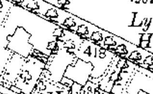
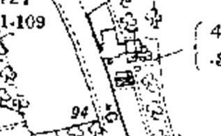
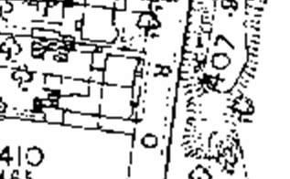
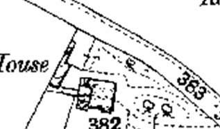
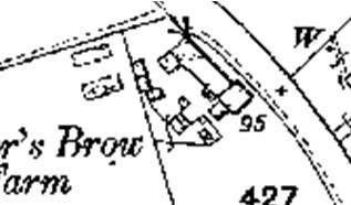
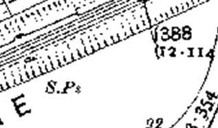
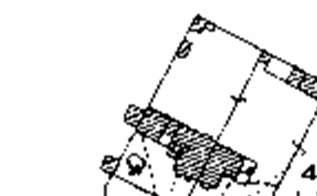
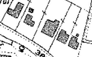
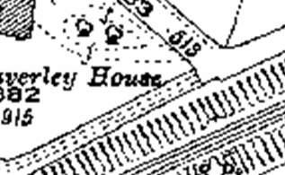
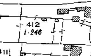
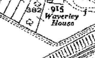
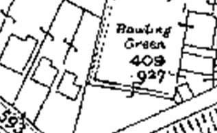
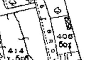
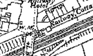
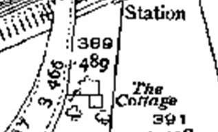
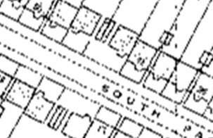
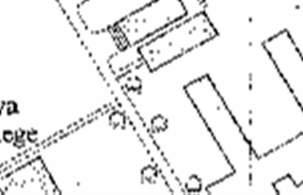
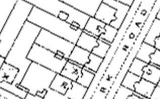
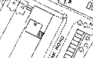
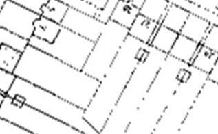
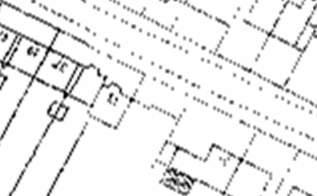
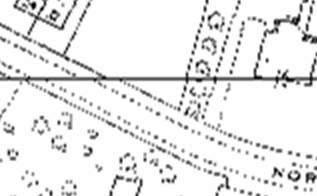
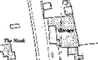
11 4 SPATIAL ANALYSIS 4 SPATIAL ANALYSIS 4.1 Layout and Patterns of Development Originally Kirkby was agricultural in character with numerous farms and fields scattered across the landscape. This aspect of the area s historic character is no longer evident in the layout and no built features within the conservation areas offer any hint of this stage of the area s development. Mid-19 th century maps depict a loose arrangement of settlement along Kirkby Row and Glover s Brow, centering on Kirkby station as the area began to develop as a suburb. North Park Road and South Park Road were developed as cul-de-sacs that branched west from Glover s Brow. Properties were built fronting onto the roads, in well-spaced regular plots, with properties built to infill vacant plots throughout the early 20 th century. This arrangement remains evident within the conservation areas, despite a few of the earlier buildings being replaced with modern flats and housing. The buildings in the conservation areas are of differing scales, predominately of semidetached houses with some large villas remaining, which are by far the most substantial structures in the conservation areas. The earlier Victorian Villas at No 16 (Lytham House) and 38 & 40 North Park Road are of very generous proportions and set within larger plots than their neighbours. Glover s Brow features a row of four semi-detached Victorian houses; Pemberton Villa and Homer Lea are positioned tightly against the pavement facing onto the main road, while its neighbours Stanley Villa and Inglehurst are set further back. In comparison the road here seems rather close to the front elevations of these properties but this has always been the arrangement, and may reflect a comparatively less planned origin. Waverley House and Nos 14 & 16 South Park Road are arguably the most dominant properties in the area, sat in extensive plots and vertically tower over adjacent properties due to their substantial proportions. These higher status buildings add considerably to the character of the area and serve as important reminders of the grander character the original development presented. Figure 3 - Extract from the 1939 Ordnance Survey Map, showing the extensive plot size of Waverley House, relative to the semi-detached properties in the South Park Road Conservation Area. 11
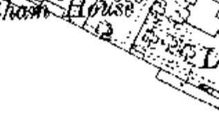
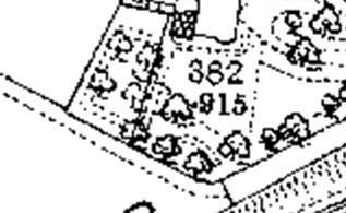
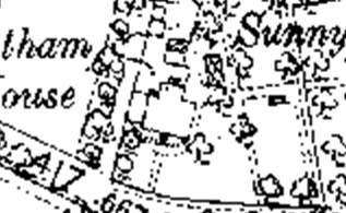
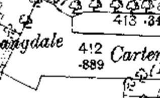
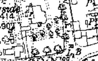
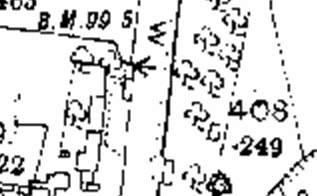
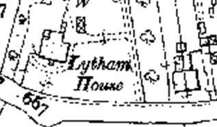
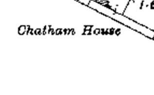
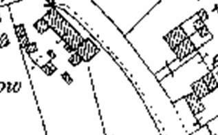
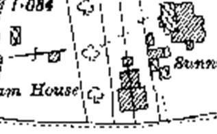
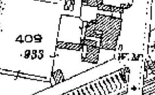
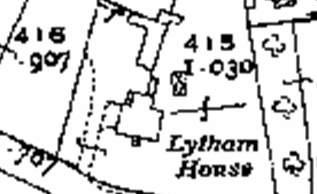
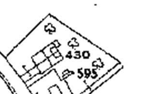
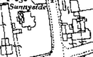
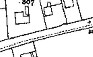
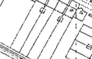
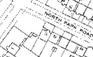
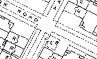
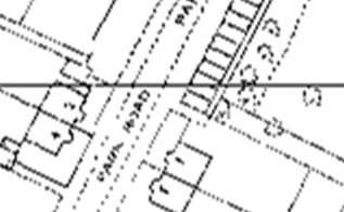
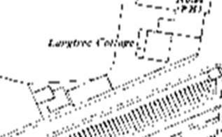
12 MAY 2017 Figure 4 - Extract from the 1927 Ordnance Survey Map, showing the extensive plot sizes of Langdale, Chatham House, Carlton House, Lytham House and Sunnyside in the North Park Road Conservation Area. Generally the earliest development is the most spacious, with development gradually becoming of lesser proportions with the progression of time. Maps from the early 20 th Century depict a wave of development within both conservation areas with the building of a number of smaller semi-detached dwellings. A number of detached properties were also built opposite Waverley House in South Park Road spaced at regular intervals. These buildings are set back from the road with small gardens or hard standing to the front, and large gardens to the rear. Although the early 20 th century development does not match the high status of the Victorian development as was originally intended for the area, the retention of deep plots and the measure of spaciousness means that the overall form of the Kirkby Park as was envisaged by its founders, is preserved to some extent. More recent infill development on gardens is less successful particularly where the spatial qualities of the former plots have been wholly undermined such as at Lytham House and Carlton House and therefore have been particularly harmful. The significant massing of these buildings and the less generously spaced and uncharacteristic layout of the plots and access roads breaks with the consistency of the historic form of development and as a result these appear as jarring elements within the conservation areas. The properties which positively contribute to the character of the conservation areas are set forward within their plots directly facing onto the road on a strong building line. In detached properties spaced at regular intervals. Both North Park Road and South Park Road are wide tree lined roads that run parallel to one another. North Park Road features a gentle curve in the road preventing views directly through the conservation area. A section of South Park Road between South Park Court and Waverley House one way westbound, which means that traffic, must exit the conservation area via Sefton Drive to return onto Glover s Brow. 12


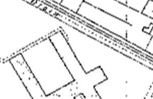
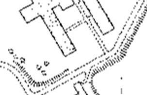
13 4 SPATIAL ANALYSIS Figure 5 An original brick boundary wall still exists at 14 & 16 South Park Road, with stone gate posts marking out the access to the properties. This boundary is a good example within the conservation area and is a significant component of the streetscape. Property boundaries are formed through a mixture of hedgerows, low wooden panel fencing, palisade fencing, railings and low walls of varying ages and styles. These directly abut the pavement. A number of original walls and gateposts remain associated with some of the original villa buildings. Their position helps to define the planned and formal layout and nature of the conservation areas, however losses to boundary walls, e.g. for accesses and wider driveways, and the poorer quality and inappropriate designs of some of the more recent elements undermines the consistency and quality of both conservation areas. It is likely the original Victorian properties here would have had outbuildings and stables situated within their grounds, but it appears that only 4 North Park Road has retained such a building which can be clearly be seen from the Anchor-Millview Retirement Home. Figure 6 An example of the remaining outbuilding at 4 North Park Road, as visible from the Anchor- Millview Retirement Home. 13

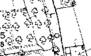
14 MAY Open Spaces, Trees and Landscaping Despite the suburban nature of the conservation areas, the planted character of the streets and private gardens contribute substantially to the character of both Conservation areas. The gardens differ in size relative to the scale of the principal property to which they relate and have been planted and laid out in a suburban style which fits in with the wider setting. The planned and formal design of the garden plots contributes to the suburban feel of the conservation areas. Where planting has been lost to parking, and particularly where large areas of hardstanding have been constructed on frontages, such as is associated with the modern flats, this detracts from the character of the streets. There are no public open spaces within the conservation areas; however the open views into gardens and their soft landscaped nature, play a major part in creating a sense of seclusion within the conservation areas. Both North Park Road and South Park Road have overhanging trees, positioned on the periphery of private gardens and/or on grassed verges that line the road. Cumulatively the trees help to create an attractive leafy corridor through the conservation areas. Within the public realm the grassed verges and street trees enhance the green and well-planted character of the conservation areas. It appears that similar verges and trees have unfortunately been removed in front of South Park Road. Mature trees can be found within the grounds of Waverley House, some of which overhang the public realm above a row of railings. Figure 7- Looking eastbound into North Park Road, showing the extensive tree cover and greenery that lines the road to give a sense of a leafy corridor through the North Park Road conservation area. 14

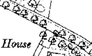
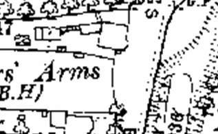
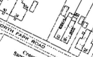
15 4 SPATIAL ANALYSIS 4.3 Focal Buildings and Views There are a number of important focal buildings within the North Park Road and South Park Road Conservation Areas, which naturally are the substantial villa properties which are prominent buildings on the streetscape. In North Park Road Conservation Area, the Carter s Arms stands at the corner of Glover s Brow. The Grade II listed property is one of the oldest public houses in Kirkby and would have once been an important part of community life. The building stands in a prominent position at the junction or Glover s Brow, North Park Road and Mill Lane. To the south of the public house stand four large semi-detached Victorian villas which make a significant contribution to the character of the locality. These buildings face onto Glover s Brow overlooking more modern houses and commercial premises situated on Station Mews. This creates a distinctive sense of juxtaposition between the old and the new and provides a highly visible link to the Victorian heritage in this part of town. The grand scale of Lytham House (16 North Park Road) creates a further focal building, w building as it of a grand scale. The building is one of the original Victorian villas to be constructed here. Its appearance is particularly grand and is indicative of the polite style of architecture that would have once been prevalent in this part of Kirkby. At the western entrance to North Park Road Conservation Area 38 & 40 North Park Road is also a focal building as a symmetrical pair of well-preserved, generously proportioned semi-detached Victorian houses. The building stands on the edge of the conservation boundary and starkly contrasts to the neighbouring post-war and modern infill housing. Alongside Lytham House (16 North Park Road) these properties would have been indicative of the type of wealthy residences to be found in this area of Kirkby in the town s formative years. Figure 8 The Carter s Arms Public House stands as a focal building on Glover s Brow within the eastern entrance to the North Park Road Conservation Area. 15

16 MAY 2017 The most significant buildings in terms of townscape in South Park Road Conservation Area are Waverley House and 14 & 16 South Park Road. These are also the most substantial buildings within that conservation area and due to their large size, Italianate influenced design, and the large plots in which they are positioned. Both buildings are significant assets of the conservation area, and positively contribute to the character and appearance of the conservation area. Views within the North Park Road conservation area are predominantly restricted to views along North Park Road itself. From the junction of Mill Lane the view of Carters Arms serves as the first indication as to the historic origins of the area. This view is attractively complemented by the tall trees that line North Park Road, trees within the garden of Anchor-Millview Retirement home and mature trees to the rear of the public house. The opposite view from within the eastern portion of North Park Road provides a similar outlook across the junction, with views towards The Smithy at the junction of Mill Lane. These buildings are Grade II listed and although they are not within the North Park Road Conservation Area, they significantly contribute to the setting and views in and out of the conservation area. Views within South Park Road conservation area are predominantly restricted to views along South Park Road itself. On entering from Glover s Brow, the townscape opens up with views across the gardens of the imposing Waverley House through the row of railings which permit easy views through the site. The view from Sefton Close looking into the conservation area is dominated by the tower of 16 South Park Road. This stands tall over the adjacent property and the semi-detached residences standing opposite. In the distance the tower of Waverley House can be seen on the skyline. The tower is therefore a feature which adds greatly to views within and towards the conservation areas. Figure 9 Views east out of the North Park Road Conservation Area look out towards the Grade II listed 1 & 3 Mill Lane and The Smithy, which contribute to the historic setting of the conservation area. 16

17 4 SPATIAL ANALYSIS 4.4 Public Realm Although North Park Road and South Park Road are generally quiet suburban roads, access to the Park Estate to the west has low permeability and therefore access must be gained via North Park Road and South Park Road. Both North Park Road and South Park Road are accessed off Glover s Brow via a traffic lighted junction and a marked junction respectively. North Park Road has a two-way traffic flow and is wide enough to accommodate typical traffic flows. South Park Road has a one-way traffic flow westbound from South Park Court to Waverley House, opening up to a two-way traffic flow for the remainder of the road. Glover s Brow is the busiest road within the conservation area and is a two-way suburban route linking Kirkby town centre to Melling Mount and Simonswood further north. The public realm elements of both conservation areas are limited to the roads and pavements, with some short sections of grassed verge. Roads within the conservation areas are surfaced with tarmac bounded with raised tarmac pavements to either side; the kerbstones appear relatively low to the ground. Vehicles can often be seen parked partly on the pavement in addition to the placing of refuse bins. At the crossroads of North Park Road, Glover s Brow and Mill Lane there is a metal guard rail that is not sympathetic to the character and appearance of the conservation area, being of standard design and suggestive of a greater traffic flow typical of an urban environment. Road markings in both the conservation area limited to the respective eastern entrances, with yellow line markings only as far as 43 North Park Road in the North Park Road Conservation Area, and as far as 17 South Park Road in the South Park Road Conservation Area. The double yellow lines are of standard colour and proportions, which is not wholly sympathetic to the sensitive character of the area. Figure 10 A view along North Park Road eastbound shows the low kerbed pavements and the unmarked tarmac road. 17

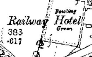
18 5 ARCHITECTURE, DETAILS AND MATERIALS 5 ARCHITECTURE, DETAILS AND MATERIALS 5.1 Building Age and Uses The buildings within the conservation areas date from the Victorian era onward. It is mainly characterised by mid-late 19th century villas, early 20th century semi-detached houses and a number of more recent late 20th and early 21st century infills. The majority of the buildings are purpose-built residential properties. The exceptions to this are the Carter s Arms Public House, Glover s Brow and Waverley House which has previously been used as the Kirkby Conservative Club. The boundary excludes modern developments of different character which sit alongside the conservation area, such as the properties found in Anchor-Millview retirement home and Millerscroft in North Park Road which are located in the former sites of demolished Victorian villas. 5.2 Architecture The oldest buildings within the conservation areas are built of styles typical to a suburban, railway influenced Victorian estate development. Italianate influences are particularly evident in the mid-late 19 th century Villas, emphasising the original wealth and grandeur of the estate. There is no clear uniformity to the style of buildings in either conservation area; construction has taken place over a long period and the styles used are those which were fashionable at the time of construction. There are remnants of pre-existing development around the conservation areas, such as old gate pillars and brick garden walls. These are highly beneficial in allowing people to read the history of the area and its wider setting. These features are also significant to the heritage and appearance of individual buildings and contribute positively to the character of the conservation areas. Figure 7 The former Conservative Club on South Park Road known as Waverley House, dates to the 1800s and is a Grade II listed building. The site appears to be unoccupied and has been subject to neglect, in addition to some earlier poor quality extensions that detract from the building. 18

19 MAY 2017 North Park Road In North Park Road Conservation Area buildings follow a number of architectural styles which can be grouped by their style and age. The early 20 th century semi-detached dwellings are rather modest and simple in appearance, in-keeping with suburban nature of this part of Kirkby. These properties offer a stark contrast to the earlier Victorian villas of North Park Road, of which a number have been demolished. These larger villas were built for the merchant classes, constructed on a grander scale, set in large gardens with imposing architectural features and stately facades. Lytham House (16 North Park Road) remains as a good example of the earlier appearance of the original buildings of North Park Road. It is a double fronted Victorian residence built of brick, with decorative stucco applied to the ground elevation. Houses in large grounds of a similar grandeur previously lined the street; these can be seen on historic maps and were named Sunnyside, Langdale and Carlton House. These would have undoubtedly possessed an equally impressive appearance. In North Park Road near to the junction of Glover s Brow there appears to be a surviving portion of a historic sandstone wall, this could be associated with the former Sunnyside that sat at the junction of Glover s Brow, and North Park Road. The house was originally sited within a large plot area, which reached to Lytham House with a stone wall bounding the site. Short rows of early 20 th century semi-detached properties stand at North Park Road built between 1927 and They are constructed of deep red brick, with slate roofs and have Edwardian style detailing, despite their relatively later date. The properties are smaller than the earlier simple Edwardian semi-detached houses at North Park Road, but do benefit from relatively large plots which are a characteristic element of the conservation area. Most have been extended, though one fortunately retains its original garage with stepped parapet.nos North Park Road although simple in design displays decorative crested roof ridges and blue brick string courses. Figure 8 30 & 32 North Park Road, built in the 1900s display a good example of the smaller scale late Victorian development, with stone headers and sills to the windows. 19

20 5 ARCHITECTURE, DETAILS AND MATERIALS Some of the more recent properties built in North Park Road are situated in Lytham Court. This small cul-de-sac features four modern houses each with their own individual appearance. In Park Court and Glover s Court, retirement home complexes have been built sites previously occupied by Victorian houses. The design of the newer buildings fails to reflect the architectural appearance and plot characteristics of the conservation area South Park Road In South Park Road there are fewer buildings of grandeur with the majority of buildings built in the 1920s and 1930s as small bungalows and small semi-detached houses. The scale of properties contrasts significantly from the large Victorian villa, Waverley House to the 1920s bungalows at 2, 4, 8 and 10 South Park Road. Waverley House is a grand Italianate Victorian villa of brick with stone dressings and a slate roof. The property boasts a large 3 storey square tower on angle with rich architectural features that reflect the high-status of the original occupants. The villa is located within significantly sized gardens, bounded by mature trees and high metal fences. Built around the same time 14 and 16 South Park Road is a symmetrical pair of grand semi-detached houses, built in the late 19 th century with richly detailed Italianate and gothic features. The properties are of brick in Flemish bond with stone dressings. Standing at 3 storeys high they offer an imposing presence, towering over the surrounding houses. In the 1920s the area saw further development with a number of properties built in similar styles typical of that period, the development comprised of bungalows and a 2 storey detached property in pebble-dash, red brick with brick quoins. Figure 9 No 4 South Park Road, a single storey 1920s infill, that changes the line of elevation within the conservation area, located opposite the much grander Victoria villa, Waverley House. 20
21 MAY 2017 Located west of Waverley House are South Park Road which were built between and are noticeably different from buildings in the street being of a largely consistent design and positioned closer together with less space between them. The rear gardens are unexpectedly elongated to match the depth of the plot at Waverley House, with small gardens to their fronts. Nos are of red engineered brick to the front elevations with common brick to the sides and rear. The properties have pitched slate roofs and single storey square bay windows with lean-to roofs. Nos and North Park Road opposite, are of similar style with hipped roofs and are fronted with a mixture of red brick and pebbledash. No have a two storey flat-topped bay window with brick arched porches and recessed doors. The properties retain their original front walls which are of good quality and add character at this the entrance to the conservation area. Later alterations to the semis that reduce the similarities, rhythm of development and visual relationships between them have been of detriment. In front of both these sets of properties are grassed verges, that within South Park Road has trees planted within it. This additional landscaping helps to compensate for the lesser size of the gardens, albeit some sections have unfortunately been removed. This layout marks them out as the continuation of the earlier phase of suburban development, prior to the mid-20 th century estates being developed in the surroundings of the conservation area 5.3 Building Materials and Details The materials evident within the conservation area signify the importance of the railway line and better transport links which came with industrial growth in the late 19 th century. The opening of the nearby railway undoubtedly assisted with the procurement of the building materials used in the construction of the older properties in this part of Kirkby, signifying a trend away from the use of local materials and vernacular styles. Buildings with the conservation area are typically constructed of red brick with slate roofs, with variant levels of decorative detailing ranging from the Italianate decorated villas to the simple late Victoria semi-detached houses. Regardless of the building material and style implemented, lime mortar/ sand pointing would have been used. It is unfortunately the case that a number of buildings have been repointed in cement/sand pointing which is harmful from both a physical and aesthetic point of view. Original stucco/render is relatively rare within the conservation areas but examples can be seen at North Park Road, and Lytham House where render has been added later it is generally a jarring feature. Pebble dash is also rare within the conservation areas but is used on the upper storeys of and South Park Road, but this material is not considered as a defining feature of the conservation area. Stucco, as seen on the front elevations of 38 & 40 North Park Road indicates the ostentatious nature of housing during the formative years of Kirkby, when owners aimed to more cheaply replicate higher quality materials of more expensive properties. Earlier houses within the conservation areas tended 21
22 5 ARCHITECTURE, DETAILS AND MATERIALS to be more elaborately decorated, such decoration and architectural detailing is proportional to their size and status. Slate is used for roofs regardless of the age or status of the building and is a unifying feature. Where alternatives such as a concrete tiles have been used, these detract from the architectural character of the older buildings in the locality. Chimney stacks and pots add interest and variety to the skyline to the conservation areas and add to the individuality of the properties. The chimneys of the four Victorian properties in Glover's Brow are particularly prominent on the skyline being considerably robust and stout in stature. Timber windows and doors would have once been prevalent throughout the conservation areas but many of these have since been replaced with modern upvc which are aesthetically harmful as their detail lack authenticity as the thickness of frames, their constructional and opening details and finishes of those used fail to replicate that of the timber originals. The size and positions of openings and the overall arrangement of glazing bars in a many replacement windows fail to reflect the original sash styles, which detracts from the character and appearance of the conservation area. New windows have been inserted into some buildings, though this is fortunately limited. Changes have also been made to many of the front doors of properties in both conservation areas where timber originals have been replaced with a variety of modern upvc designs which do not respect the architectural style or period of the buildings. Many houses have lost their original brick garden walls. Where original walls remain they make a positive contribution to the appearance of the streetscape. Hedges complement the green planted character of the area and are also a positive element of the area. Despite the loss of historic boundary treatments some properties have at least retained their original stone gate pillars which are attractive features in themselves and complement the buildings they front. Boundaries are now mainly defined by a mix of brick walls, hedges, railings and fencing. The walled boundaries are considered as a key element of the conservation area, and further degradation of these elements would be additionally harmful. 5.4 Listed Buildings There are several Grade II listed buildings in the conservation areas; these heritage assets are nationally important and add significantly to local interest. 14 & 16 (Ivylea) South Park Road Dating from the late 19 th century, these are a pair of semi-detached Victorian houses of three storeys, with flanking square towers over doorways. They are built of red brick laid in Flemish Bond with decorative brick and stone dressings around the openings. This detail is rare within the conservation areas and contributes positively to the conservation area. 22
23 MAY 2017 Lytham House, 16 North Park Road Lytham House was built in the late 1860's by Christopher Wade who named it after his birthplace. It is a detached Victorian two storey house built of brick and the ground floor stuccoed with horizontal grouting. It was one of the original buildings to be constructed in Kirkby Park and is one of only a small number which survive from that period. 38 & 40 North Park Road A pair of late Victorian semi-detached houses, of two storeys with painted stucco, and slate roofs. The large symmetrical form of these buildings adds to the sense of the planned layout of the conservation area, and is exemplar of the imposing nature early houses here would have exhibited. The Carters Arms, Glover s Brow The 19 th century two storey public house is of scored stucco with a slate roof hipped on the right. Despite having undergone a series of alterations, the building still retains its grand architectural style and remains as a local landmark within the area. This would have been the centre of village life before the influx of new residents in the 20 th century. Waverley House, South Park Road Waverley House is one of the earliest buildings remaining in the conservation developed in the mid-late 19 th century. It is a large and imposing Victorian villa set within its own grounds of brick with stone dressings and a slate roof. The villa evokes a sense of the wealth of the Liverpool businessmen who developed speculative villa suburbs along the Liverpool, Bolton and Bury railway line. The grand villa has a three-storey square tower of Italianate influenced architecture, which adds visual interest to views within and outside of the conservation area as a landmark feature. 5.5 Locally Listed Buildings A present Knowsley Council does not have a Local List. However, the Council is in the process of collating a list of locally important buildings which are significant to the local area and the Borough. Potential inclusions for the local list include: Chatham House, North Park Road. Inclusion on a local list does not give statutory protection and therefore development would not always require planning permission, however where applications are required close scrutiny will be given to any development that may affect the significance and/or setting of a locally listed building. 23
24 6 SUMMARY OF KEY CHARACTERISTICS 6 SUMMARY OF KEY CHARACTERISTICS North Park Road and South Park Road conservation areas were developed in the mid-19 th century as suburbs for the middle classes. However development was slow and as the town grew throughout the later 19 th Century and the early 20 th century new properties were constructed as some larger properties were lost. Today the conservation areas boast a mixture of architectural styles owing to the piecemeal pattern of development. The layout and streetscape of the conservation areas has largely survived despite the town s growth and the development of the Park Estate which encloses the conservation areas to the west. The most notable features of the conservation areas are the surviving original villas, walled boundaries and mature tree cover. A number of plots fortunately retain their original size, with many properties enjoying unusually large rear gardens which add to the sense of status of the area. The key characteristics of the conservation areas can be summarised as: Both Conservation areas are mid-19 th century suburbs developed concurrently with the coming of the railway; The most notable and positive features of the conservation areas are the grand Victorian villas, their notably large plots, and well-spaced layout Mature trees and well planted gardens; Early 20 th development is generally of good quality and adds to the architectural variety and promotes understanding of the historic development of the area; The sites that contribute positively to the conservation area often have large plot sizes, with many properties enjoying unusually large rear or proportionately larger than average gardens; Properties have a consistent building line and all face on to North Park Road, South Park Road or Glover s Brow, where this not occur e.g. the cul-de-sac infill, the character of the road is interrupted; The seven large Grade II listed buildings that date from the mid-late 19 th century including the Victorian Villas, large semi-detached houses and a public house are focal buildings; Waverley House is a large and imposing Grade II Victorian Villa set within large grounds. Its distinctive square tower at the eastern gateway of South Park Road provides a striking landmark; The use of brick and slate; Low front boundaries are set directly on the back of the pavement, the few original brick and / or sandstone walls remaining are of particular interest. 24
25 7 ISSUES AND OPPORTUNITIES FOR ENHANCEMENT 7 ISSUES AND OPPORTUNITIES FOR ENHANCEMENT 7.1 Conservation Area Boundary Review The North Park Road Conservation Area boundary as it currently stands would benefit from review in accordance with Historic England Advice Note 1 (2011) Conservation Area Designation, Appraisal and Management. The existing boundary designated in 1978, is now outdated, following infill development and illogical boundary. There are no suggested boundary amendments to the South Park Road Conservation Area as the existing boundaries remain relevant. Suggested Boundary Amendments Proposed Additions 31 & 33 North Park Road The current boundary extends only to include parts of curtilage to 33 North Park Road and 9-12 Glover s Court and does not include the full boundary of these properties, due to the creation of new boundaries caused by the partial demolition of the Convent for the Sacred Heart of Mary Convent and the new development at Millerscroft. It is recommended that the conservation area boundary be extended to the full property boundaries. This would be a coherent and logical approach consistent with Historic England Advice Note 1 (paragraph 66), which states that a unified approach is desirable to their management as well as suggesting that in almost all situations the conservation area boundary runs around rather than through a space or plot. Public Realm to the south of North Park Road To the south of North Park Road the conservation area boundary excludes North Park Road itself making the boundary ill-defined by features on the ground. The extension of the conservation area is suggested to include the full extent of the road and surrounding pavement up to the property boundaries of 5 & 6 Millerscroft and aligned to the western boundary of 40 North Park Road. This approach would comply with paragraph 17 of the Historic England Advice Note 1 (2011) and paragraph 66 which states that conservation area boundaries will generally be defined by physical features. Public Realm to the east of The Carter s Arms To the east of The Carter s Arms the conservation area boundary extends partly out into the public pavement on the western side of Glover s Brow, but this boundary is ill-defined by features on the ground. The extension of the conservation area is suggested to include the full extent of the pavement up to the road. This approach would comply with current national guidance as outlined above. 25
26 MAY Design of Development Previous changes to historic buildings within the conservation area have not always been sympathetic to the character of the area. For example infill development and creation of hardstanding in the former gardens of the larger villas has harmed the spacious and green qualities of their gardens. Extensions and garage conversions should take into account the historic design if the host building, seeking to enhance this where possible. The layout and positioning of dome development fails to harmonise with the historic street pattern and plot sizes. The cul-de-sac form of Lytham Court is of an alien layout which detracts from the established historic layout. The open plan nature of the development and new road with large corner radii to the junction is additionally uncharacteristic. More recent blocks of flats such as Park Court and Glovers Court are of a massing which do not relate to the historic forms of development, or respond positively to established building lines; these also have significant and clearly visible areas of hardstanding for parking. 7.3 Alterations to Features Not all changes to historic buildings are sympathetic to the character of the conservation areas. For example, replacement upvc windows and doors detract from the architectural character of the properties. Where replacement features include Wood effect finishes and designs which noticeably differ from the originals the impacts are especially harmful. Changes to buildings should take into account the historic design, age and character of the host building, seeking to enhance this where possible. 7.4 Setting of Conservation Area The conservation areas are surrounded to the west and divided by mid-20th century estate housing developments, where repeated forms are prevalent and are wholly different in character to the conservation areas. The wider setting of the railway is particularly significant in regards to the historic development of the area and opportunities to promote the relationship between the conservation areas and the railway line should be maximised. 7.5 Traffic and Pedestrian Movement North Park Road and South Park Road are relatively quiet areas with low traffic flows. Glover s Brow is a busier road controlled by traffic lights and speed bumps; however traffic does not appear to be unduly heavy during non-peak times. Generally, highways signs and line marking are minimal; this should be maintained and further simplifications undertaken where permissible. Permeability between the two conservation areas is poor, especially for pedestrians, with no clear route connecting the two. The pedestrian footpaths are wide enough to accommodate most uses, however at some times this is compromised by on pavement parking and inconsiderate location of refuse bins. 26
27 7.6 Vacancy and Condition 7 ISSUES AND OPPORTUNITIES FOR ENHANCEMENT Some of the larger properties within the conservation areas would benefit from maintenance works. Waverley House, South Park Road is of significant interest, however appears to be vacant and in worsening condition. It would benefit from a new use to avoid dereliction. The plot of land between 10 & 12 South Park Road is vacant and overgrown. It appears never to have been developed since the area was laid out. 7.7 Enforcement Issues Some properties have had some inappropriate alterations, such as the installation of inappropriate doors and windows. It would be beneficial to undertake a survey to check that existing features benefit from the appropriate permissions, and provide a baseline from which future changes to the conservation area can be monitored. 7.8 Article 4 Directions The conservation areas do not currently have Article 4 Directions in place. The creation of an Article 4 Direction would enable the local planning authority to exercise planning control over a greater range of minor alterations to residential properties which could otherwise be carried out by a property owner without planning permission under their permitted development rights. Alterations such as the installation of replacement doors and windows, re-roofing in modern materials, the removal of chimneys, creation of dormer windows, the addition of porches, the demolition of boundary walls etc., can all be controlled by Article 4 Directions. The conservation area is not currently under an Article 4 direction but this may be a step to be considered in the near future due to the noticeable impact that these minor changes are having within the area. Given the significant loss to features which is evident already, adoption of these measures would have greater impact if there was demonstrable public support. 7.9 Opportunities for Enhancement There are a number of opportunities to enhance the character and appearance of the conservation area. Further details will be set out in the Conservation Area Management Plan for the North Park Road and South Park Road Conservation Areas. The key areas that would benefit from enhancement area: Reinstating the lost grass verges and trees along the roads as this would add to the planted and suburban character of the street; 27
28 MAY 2017 Some buildings and structures would benefit from suitable maintenance and repairs, e.g. localised repair and maintenance using appropriate materials; Some properties would benefit from the reinstatement of traditional architectural details to buildings, e.g. replacing upvc with traditional timber frame windows; The vacant site at 12 South Park Road would benefit from general tidying and upkeep; its development with suitably designed development of a nature and scale which complements and enhances the character of the conservation area would be supported, as this would complete the street scene. The provision of heritage interpretation materials detailing the significance of the area and its history; Some of the public footpaths in the area would benefit from repair and maintenance, where cracked and in poor condition; Provision of specific design guidance for additions and alterations; One building identified in this Conservation Area Appraisal would benefit from being locally listed and included on a local list. The building for consideration is: Chatham House (North Park Road). Further details will be set out in the Conservation Area Management Plan for the North Park Road and South Park Road Conservation Areas. 28
29 8 REFERENCES 8 REFERENCES Cowell, R. (1982). Knowsley Rural Fringes Report Survey Report. Merseyside County Museums: Liverpool. Eckwall, E. (1960). The Concise Oxford Dictionary of English Place-Names. London: Oxford University Press. 4 th Edition. Griffiths, Michael (1995). Kirkby & Knowsley. Gloucestershire: Nonsuch. Jensen, Finn (2007). The English Semi-detached House. Huntingdon: Ovolo Publishing. National Museums Liverpool (2011). Merseyside Historic Characterisation Project. Liverpool Museums: Liverpool. Pevsner, N. (1969). The Buildings of South Lancashire. Harmondsworth: Penguin. Roberts, Joan (1976). Kirkby: A Short History. Liverpool: Knowsley MBC. 29


30 APPENDIX 1 APPENDIX 1 Historic Map


31 APPENDIX 2 APPENDIX 2 Historic Map 1893 A 31


32 APPENDIX 3 APPENDIX 3 Historic Map


33 APPENDIX 4 APPENDIX 4 Historic Map 1927 A 33


34 APPENDIX 5 APPENDIX 5 Historic Map


35 APPENDIX 6 APPENDIX 6 Historic Map 1962 A 35

36 APPENDIX 7 APPENDIX 7 36

37 APPENDIX 8 APPENDIX 8 37
STRENSALL RAILWAY BUILDINGS CONSERVATION AREA APPRAISAL. In association with Strensall with Towthorpe Parish Council
 STRENSALL RAILWAY BUILDINGS CONSERVATION AREA APPRAISAL In association with Strensall with Towthorpe Parish Council CONTENTS Page 1 Introduction 2 2 Location and Context 3 3 Topography and Setting 4 4
Lancaster Conservation Area Appraisal. Character Area 8. Cathedral
 Lancaster Conservation Area Appraisal Character Area 8. Cathedral March 2013 118 3.8 Character Area 8. Cathedral 3.8.1. Definition of Special Interest "This character area is distinctive for the fine group
Conservation Area Designation, amendments and Review
 Conservation Area Designation, amendments and Review Location: Any area largely confined to Park Road and St. James Avenue which includes the following properties: St. James Church, St. James Road; No.
Conservation Area Designation, amendments and Review
 Conservation Area Designation, amendments and Review Location: No.s 37-49 (odd) Twickenham Road Date Assessed: January 2018 Adjacent Conservation Area Significance: Teddington Lock CA. The Teddington Lock
MATURE SUBURBS RESIDENTIAL DEVELOPMENT GUIDELINES
 MATURE SUBURBS RESIDENTIAL DEVELOPMENT GUIDELINES DRAFT FEBRUARY 2005 BIRMINGHAM CITY COUNCIL 1 Introduction Mature Suburbs Residential Development Guidelines - Interim Supplementary Planning Advice -
Appraisal of proposed alterations to the boundary of Helmsley Conservation Area
 Appraisal of proposed alterations to the boundary of Helmsley Conservation Area Elmslac Road: Elmslac Road was constructed in the early 1950s in two or three stages by the Helmsley Rural District Council.
5 Gratton Terrace London NW2 6QE. Reference: 17/5094/HSE Received: 4th August 2017 Accepted: 7th August 2017 Ward: Childs Hill Expiry 2nd October 2017
 Location 5 Gratton Terrace London NW2 6QE Reference: 17/5094/HSE Received: 4th August 2017 Accepted: 7th August 2017 Ward: Childs Hill Expiry 2nd October 2017 Applicant: WSD (Gratton) Ltd Proposal: The
DESIGN & ACCESS STATEMENT
 . DESIGN & ACCESS STATEMENT Site Adjacent to The Manor House, Upper Street,, Kingsdown, Deal, Kent. DESIGNS ARCHITECTURE + PLANNING CONTENTS Design and Access Statement Introduction Site and Location Planning
DRAFT CONSERVATION AREA APPRAISAL CHAILEY GREEN DESIGNATED
 DRAFT CONSERVATION AREA APPRAISAL CHAILEY GREEN DESIGNATED 16.06.76 DRAFT CHAILEY GREEN CONSERVATION AREA APPRAISAL 1 SUMMARY 1.1 Key Positive Characteristics 1.2 Recommendations 2 INTRODUCTION 2.1 The
UPPER GORDON ROAD TO CHURCH HILL, CAMBERLEY CONSERVATION AREA
 Introduction This leaflet explains the purpose of conservation areas and the implication of their designation for residents, property owners and the Council. It provides you with a plan of the area and
GREAT WESTERN SQUARE & ENVIRONS
 GREAT WESTERN SQUARE & ENVIRONS Draft Architectural Conservation Area Report Character Appraisal and Policy Framework 20 1 Architectural Conservation Area Report: GREAT WESTERN SQUARE & ENVIRONS Draft
PLANNING COMMITTEE. 14 October 2014
 AGENDA ITEM NO 8 PLANNING COMMITTEE 14 October 2014 APPLICATION NUMBER : CA//14/01744/FUL PROPOSAL : Extension and conversion of roof space of an existing detached bungalow together with enhanced parking
1 The development hereby permitted shall be carried out in accordance with the following approved plans:
 Location 59 Greenway Close London N20 8ES Reference: 16/00011/HSE Received: 30th December 2015 Accepted: 7th January 2016 Ward: Totteridge Expiry 3rd March 2016 Applicant: Mr Ankit Shah Proposal: Part
7.1 Area 1: Haslemere Conservation Area
 7.1 Area 1: Haslemere Conservation Area Detailed map of Haslemere Town Conservation Area as of 2006 Crown copyright and database right 2011 Ordnance Survey LA100025451 27 The Conservation Area is characterised
Character Area 1: Town Core
 Character Area 1: Town Core Map S 354 Copyright Cotswold District Council 109 Character Area 1: Town Core Key Characteristics 355 356 357 358 359 360 361 362 363 364 365 366 367 368 369 370 Copyright Cotswold
Reference: 16/1447/FUL Received: 7th March 2016 Accepted: 7th March 2016 Ward: East Finchley Expiry 2nd May 2016
 Location 374B Long Lane London N2 8JX Reference: 16/1447/FUL Received: 7th March 2016 Accepted: 7th March 2016 Ward: East Finchley Expiry 2nd May 2016 Applicant: Ms Katrin Hirsig Proposal: Single storey
Environmental and Landscape Mapping
 Environmental and Landscape Mapping In support of the Calveley Neighbourhood Plan November 2016 Project Name and Number: Calveley Neighbourhood Plan 16-025 Document Name and Revision: Environmental and
National Character Area 70 Melbourne Parklands
 Summary The are a landscape of rolling farmland, parkland and woodland on the northern flanks of the ridge between Burton upon Trent and Swadlincote. The land slopes down to the River Trent, which borders
Case Studies; Meitheal Clusters Applied to Villages and Rural Settlements
 Case Studies; Meitheal Clusters Applied to Villages and Rural Settlements 23.3.9 (ii) Case Studies, Meitheal Clusters applied to villages and rural settlments Fig 22.3.12 Cluster site plan; church opposite
ENVIRONMENTAL AND LANDSCAPE MAPPING
 APPENDIX IV : Environmental and Landscape Mapping ENVIRONMENTAL AND LANDSCAPE MAPPING Calveley Neighbourhood Plan November 2016 ENVIRONMENTAL AND LANDSCAPE MAPPING Calveley Neighbourhood Plan Calveley
Conservation Area Designation, amendments and Review
 Conservation Area Designation, amendments and Review Location: Are area largely confined to Cowley Road and North Warpole Way and incorporating the following properties: No.s 2-120 (even) & 61 123 (odd)
3 Abbey View Mill Hill London NW7 4PB
 Location 3 Abbey View Mill Hill London NW7 4PB Reference: 15/03203/HSE Received: 26th May 2015 Accepted: 16th June 2015 Ward: Mill Hill Expiry 11th August 2015 Applicant: Proposal: Mr Richard Benson Alterations
DEVELOPMENT MANAGEMENT REPORT
 ITEM A08-1 DEVELOPMENT MANAGEMENT REPORT TO: BY: DATE: DEVELOPMENT: SITE: WARD: APPLICATION: APPLICANT: Development Management Committee Development Manager Proposed live/work unit in connection with existing
Land Adj. 63 Sunny Bank Road, Sutton Coldfield, Birmingham, B73 5RJ
 Committee Date: 11/07/2013 Application Number: 2013/03520/PA Accepted: 20/05/2013 Application Type: Full Planning Target Date: 15/07/2013 Ward: Sutton Vesey Land Adj. 63 Sunny Bank Road, Sutton Coldfield,
Exploring Abergavenny
 11 Majors Barn36 Ysguborwen Exploring Abergavenny 2 ysguborwen EXPLORING ABERGAVENNY For several years the Abergavenny and District Civic Society has been studying the streets, spaces and buildings of
Lincoln Townscape Assessment. Sherbrooke Inherited Character Area Statement
 Lincoln Townscape Assessment Sherbrooke Inherited Character Area Statement June 2008 Page 2 of 15 Table of Contents Page Overview 2 Historical Development 3 Urban form 4 Views 8 Condition of Buildings
Status of Supplementary Planning Guidance OLD WOKING CONSERVATION AREA Character Appraisal and design Guidance
 Status of Supplementary Planning Guidance OLD WOKING CONSERVATION AREA Character Appraisal and design Guidance Status This Planning Guidance which is supplementary to Policy BE9 of the Woking Borough Local
an Inspector appointed by the Secretary of State for Communities and Local Government
 Appeal Decision Site visit made on 23 January 2017 by Gareth Wildgoose BSc (Hons) MSc MRTPI an Inspector appointed by the Secretary of State for Communities and Local Government Decision date: 6 February
LONGDEN VILLAGE DEVELOPMENT STATEMENT
 LONGDEN VILLAGE DEVELOPMENT STATEMENT 2017-2027 1 Longden Development Statement 2017-2027 15/01/18 1. Background 1.1 Longden Village Longden village is a very rural and traditional community first mentioned
Character Area 9. Residential: South West
 Lancaster Conservation Area Appraisal Character Area 9. Residential: South West March 2013 128 3.9 Character Area 9. Residential: South West 3.9.1. Definition of Special Interest "This character area is
Neighbourhood Planning Local Green Spaces
 Neighbourhood Planning Local Green Spaces Introduction... 2 1. Why green space is important... 4 2. Neighbourhood plans and green space... 6 3. Evidence... 8 Statutory designations... 9 Green space audit...
Part 11 Heritage Area Plans West Wallsend / Holmesville
 TABLE OF CONTENTS: PART 1 WEST WALLSEND / HOLMESVILLE HERITAGE AREA PLAN... 3 1.1 INTRODUCTION... 3 1.2 BACKGROUND... 3 1.3 LAND TO WHICH THIS PLAN APPLIES... 3 PART 2 WEST WALLSEND / HOLMESVILLE HERITAGE
Public Consultation. Land at Monks Farm, North Grove. Welcome
 Welcome Welcome to our public exhibition for development on Land at Monks Farm, orth Grove. Gallagher Estates and Gleeson Strategic Land are preparing an outline planning application for new homes, open
30. Riverstown Mini-Plan
 County Development Plan 2017-2023 Consolidated Draft + Adopted Amendments August 2017 Volume 2, Chapter 30 Riverstown Mini-Plan 30. Riverstown Mini-Plan Village profile Riverstown is located approximately
Wide asphalt driveway abutting school property. garage built with incompatible materials, too close to park. incompatible fencing materials
 Wide asphalt driveway abutting school property incompatible fencing materials garage built with incompatible materials, too close to park Lack of plantings as a buffer between private property and open
Character Appraisal Zone 1: Charlotteville. i Topography, Views and Vistas
 Conservation Area Study and 3 Zone 1: Charlotteville For boundaries, please refer to Map 2 in the Appendices at the rear of this document. Charlotteville has a strong identity distinct from other parts
INTRODUCTION CURRENT APPLICATION
 05/01805/FUL & 05/01807/LBC ERECTION OF A SINGLE DWELLING HOUSE WITH ANCILLARY ACCOMMODATION AT Flamingo Zoological Gardens, Olney Road, Weston Underwood FOR Mr A J Crowther (as amended by letter dated
STATEMENT OF OBJECTION TO THE PROPOSED DEVELOPMENT OF LAND AT CHURCH CLIFF DRIVE FILEY
 STATEMENT OF OBJECTION TO THE PROPOSED DEVELOPMENT OF LAND AT CHURCH CLIFF DRIVE FILEY You will be aware that Scarborough borough council have adopted a new local plan that includes land at Church Cliff
Lincoln Townscape Assessment. Boultham Park Inherited Character Area Statement
 Lincoln Townscape Assessment Boultham Park Inherited Character Area Statement January 2008 Page 2 of 12 Table of Contents Page Overview 2 Historical Development 2 Urban form 3 Views 5 Condition of Buildings
Purpose of the Variation: The purpose of an ACA is to protect and enhance the special character of the ACA by:
 To the Lord Mayor and Report No. 202/2017 Members of Dublin City Council Report of the Assistant Chief Executive Proposed Draft Variation (No. 2) of Dublin City Development Plan 2016 2022 Designating Hollybrook
HERITAGE COUNTS 2017 East of England
 HERITAGE COUNTS 2017 East of England Introduction Heritage Counts 2017 is the sixteenth annual survey of the state of England s historic environment. This Regional Report is prepared by Historic England
BROADHEMBURY DESIGN STATEMENT
 BROADHEMBURY DESIGN STATEMENT As drawn up by Broadhembury Parish Council during the development of a Parish Plan and adopted at its meeting on 17 th May 2010 BROADHEMBURY DESIGN STATEMENT Contents Introduction
DESIGN GUIDANCE NOTE NO: 5 EXTENSIONS TO HOUSES
 DESIGN GUIDANCE NOTE NO: 5 EXTENSIONS TO HOUSES This note is one of a series providing design guidance for development in the borough. It explains the criteria used by the council to decide planning applications
INCREMENTAL CHANGE AREA REVIEW March 2015 Page 1
 INCREMENTAL CHANGE AREA REVIEW March 2015 Page 1 Table of Contents Introduction... 3 Background to Review... 3 Comparison of the Schedules to the General Residential Zone... 7 Methodology... 7 Policy Context...
WINDSOR GLEN DESIGN GUIDELINES
 WINDSOR GLEN DESIGN GUIDELINES Adopted by Council, 2006 WINDSOR GLEN REDEVELOPMENT DESIGN GUIDELINES August 2006 1.0 Master Plan Organization For this area of the Coquitlam Town Centre, a mix of high,
Derry City and Strabane District Council Planning Committee Report
 Derry City and Strabane District Council Planning Committee Report COMMITTEE DATE: 23 rd March 2016 APPLICATION No: APPLICATION TYPE: PROPOSAL: LOCATION: APPLICANT: LA11/2015/0395/F Residential Development
an Inspector appointed by the Secretary of State for Communities and Local Government
 Appeal Decision Site visit made on 6 November 2017 by Rachel Walmsley BSc MSc MA MRTPI an Inspector appointed by the Secretary of State for Communities and Local Government Decision date: 19 th January
APP/G1630/W/15/
 Appeal Decision Site visit made on 20 October 2015 by William Fieldhouse BA (Hons) MA MRTPI an Inspector appointed by the Secretary of State for Communities and Local Government Decision date: 20 November
Yorkshire Dales National Park Authority
 Yard 1 2 Plane Tree The Reading Room Yorkshire Dales National Park Authority Application Code: Committee Date: 08/12/2015 Location: Prospect, Und FW Blea Head Path Track Track Bridge Path Und New Cowside
DRAFT/02. Our Place. Westbury-on-Trym. City Design Group. July 2013 City Design Group
 DRAFT/02 City Design Group Contents Preface 1. Introduction 2. Character and distinctiveness 3. Character Areas 1 Henbury Road environs 2 Commercial core 3 College and Church Road environs 4 Channell
Schedule of Planning Applications Committee Date: 23 May Reference: 06/17/0726/F Parish: Hemsby Officer: Mr J Beck Expiry Date:
 Schedule of Planning Applications Committee Date: 23 May 2018 Reference: 06/17/0726/F Parish: Hemsby Officer: Mr J Beck Expiry Date: 22-05-2018 Applicant: Proposal: Site: Mr Gillett Change of use to the
Warren Farm, Ampthill
 1 Welcome The developers of the Warren Farm site, Bloor Homes and Connolly Homes, are holding this exhibition on the emerging Design Codes for the development prior to their formal submission to Central
WELLINGTON HOSPITAL DESIGN GUIDE TABLE OF CONTENTS
 WELLINGTON HOSPITAL DESIGN GUIDE TABLE OF CONTENTS 1.0 Introduction Page 2 The Place of Wellington Hospital 2 The Future of the Hospital 2 2.0 The Intention of the Design Guide 3 3.0 Analysis 4 General
Extract from Whitehorse Planning Scheme - LOCAL PLANNING POLICIES - CLAUSE Preferred Character Statements
 Extract from Whitehorse Planning Scheme - LOCAL PLANNING POLICIES - CLAUSE 22.03 22.03-5 Preferred Character Statements Bush Environment The streetscapes will be dominated by vegetation with subservient
Reference: 16/1234/HSE Received: 25th February 2016 Accepted: 2nd March 2016 Ward: High Barnet Expiry 27th April 2016
 Location 7 Sunset View Barnet EN5 4LB Reference: 16/1234/HSE Received: 25th February 2016 Accepted: 2nd March 2016 Ward: High Barnet Expiry 27th April 2016 Applicant: Proposal: Mr & Mrs Peter & Anny Woodhams
ACTION TAKEN BY CABINET MEMBER (EXECUTIVE FUNCTION) 26 September 2013
 26 September 2013") ACTION TAKEN BY CABINET MEMBER (EXECUTIVE FUNCTION) Subject Finchley Garden Village Conservation Area Character Appraisal, Management Proposals and Design Guidance Cabinet Member Date of Decision 26 September
ACTION TAKEN BY CABINET MEMBER (EXECUTIVE FUNCTION) Subject Finchley Garden Village Conservation Area Character Appraisal, Management Proposals and Design Guidance Cabinet Member Date of Decision 26 September
Eastern Golf Course, Doncaster Road, Doncaster
 , 463-535 Road, Heritage Assessment in accordance with Schedule to the Development Plan Overlay July 2013 bryce raworth conservation urban design 19 Victoria Street St Kilda Vic 3182 , 463-535 Road, Heritage
LETTER OF OBJECTION LAND TO THE SOUTH WEST OF FORGE GARAGE, HIGH STREET, PENSHURST, KENT, TN11 8BU
 Senior Planning Officer Andrew Byrne Sevenoaks District Council Community & Planning Services PO Box 183 Argyle Road Sevenoaks Kent TN13 1GN 04 November 2011 Your Ref: 11/02258/FUL For the attention of
Parish Derry Slopes ITM Coordinates ; NG Coordinates C House B1 and farm buildings B2; Registered Garden L061
 Asset Ref No. HB/01/27/018A-C, Ballyarnett & Farm; Registered Historic Garden L061 Heritage Type Location Protection Status Condition Ownership (if known) Built Post-Medieval house & farm OS 6-inch map
Tennis Court Rear Of 3-5 Corringway London NW11 7ED
 Location Tennis Court Rear Of 3-5 Corringway London NW11 7ED Reference: 18/4122/FUL Received: 3rd July 2018 Accepted: 3rd July 2018 Ward: Garden Suburb Expiry 28th August 2018 Applicant: Ms Sarah Robinson
2014/0590 Reg Date 26/06/2014 Chobham
 2014/0590 Reg Date 26/06/2014 Chobham LOCATION: PROPOSAL: TYPE: APPLICANT: OFFICER: ASCOT PARK POLO CLUB, WESTCROFT PARK FARM, WINDLESHAM ROAD, CHOBHAM, WOKING, GU24 8SN Erection of a two storey detached
PLANNING STATEMENT. Market House Market Place Kingston upon Thames KT1 1JS
 PLANNING STATEMENT To support planning and listed building consent applications for change of use from Class A1 shop and Class A3 cafe to Class A3 restaurant at: Market House Market Place Kingston upon
List of Buildings of Local Architectural or Historic Interest BUCKHURST HILL PARISH
 List of Buildings of Local Architectural or Historic Interest BUCKHURST HILL PARISH 1. ST. STEPHEN'S CHURCH Albert Road /Buckhurst Way Attractive, albeit modest, late 19th century church (date stone 1876)
Draft Part 11 Heritage Area Plans West Wallsend / Holmesville
 TABLE OF CONTENTS: PART 1 WEST WALLSEND / HOLMESVILLE HERITAGE AREA PLAN... 3 1.1 INTRODUCTION... 3 1.2 BACKGROUND... 3 1.3 LAND TO WHICH THIS PLAN APPLIES... 3 PART 2 WEST WALLSEND / HOLMESVILLE HERITAGE
Doncaster Christ Church Conservation Area
 Doncaster Christ Church Conservation Area Review June 2017 www.doncaster.gov.uk/conservationareas Doncaster Christ Church Conservation Area Review Since the appraisal was finalised in February 2011, the
Ipswich Issues and Options for the Ipswich Local Plan Review, August 2017, Public Consultation
 Ipswich Issues and Options for the Ipswich Local Plan Review, August 2017, Public Consultation Having reviewed the issues and options documents, the Society has made the following response: Part 1 Strategic
REFERENCE: B/03745/12 Received: 02 October 2012 Accepted: 05 October 2012 WARD(S): Totteridge Expiry: 30 November 2012.
: Totteridge Expiry: 30 November 2012.") LOCATION: 15A Pyecombe Corner, London, N12 7AJ REFERENCE: B/03745/12 Received: 02 October 2012 Accepted: 05 October 2012 WARD(S): Totteridge Expiry: 30 November 2012 Final Revisions: APPLICANT: PROPOSAL:
LOCATION: 15A Pyecombe Corner, London, N12 7AJ REFERENCE: B/03745/12 Received: 02 October 2012 Accepted: 05 October 2012 WARD(S): Totteridge Expiry: 30 November 2012 Final Revisions: APPLICANT: PROPOSAL:
6. Design and Architectural Guidance
 6. Design and Architectural Guidance The following Design Guidelines are proposed to apply to all areas of Haslemere. They are intended to enhance and maintain the character and scale of the area. Principles
Colchester Northern Gateway Master Plan Vision Review Draft. July 2016
 Colchester Northern Gateway Master Plan Vision Review Draft July 2016 Contents Introduction 4 Context 8 Purpose of the Report 8 Strategic Position 9 Overview of the Process 11 2012 Master Plan Vision 12
4.0 URBAN DESIGN FRAMEWORK. The vision for the future development of the plan area is to:
 4.0 The vision for the future development of the plan area is to: Create a new neighbourhood that focuses on the highly valued natural and aesthetic features of the lands and provides good quality homes,
Chapter 8: BEACH SOUTH OF ATLANTIC AVENUE NEIGHBORHOOD PLANNING AREA ANALYSIS
 Chapter 8: BEACH SOUTH OF ATLANTIC AVENUE NEIGHBORHOOD PLANNING AREA ANALYSIS The Beach South of Atlantic Avenue Neighborhood Planning Area includes the parcels adjacent to S Fletcher Avenue from Atlantic
Settlement Boundaries Methodology North Northumberland Coast Neighbourhood Plan (August 2016)
") Introduction This background paper sets out a methodology for the definition of settlement boundaries in the North Northumberland Coast Neighbourhood Plan. The neighbourhood plan is planning positively
Introduction This background paper sets out a methodology for the definition of settlement boundaries in the North Northumberland Coast Neighbourhood Plan. The neighbourhood plan is planning positively
PUBLIC REALM STRATEGY
 CONSULTATION DRAFT PUBLIC REALM STRATEGY Trenchard Street & Frogmore Street City Design Group Place Directorate Public Realm Strategy Trenchard Street & Frogmore Street Contents 1. Introduction 2. Understanding
Site north of Hattersley Road West (east of Fields Farm Road), Hattersley
, Hattersley") Application Number 17/00982/REM Proposal Site Applicant Recommendation Reason for report Application for the approval of reserved matters (means of access, landscaping, layout, scale and appearance) relating
Application Number 17/00982/REM Proposal Site Applicant Recommendation Reason for report Application for the approval of reserved matters (means of access, landscaping, layout, scale and appearance) relating
COURTHOUSE CAMPUS BARNSLEY Executive Summary March 2010
 COURTHOUSE CAMPUS BARNSLEY Executive Summary March 2010 Estell Warren Cartwright Pickard Buro Happold King Sturge BWA Barnsley Metropolitan Borough Council introduction Courthouse Campus is the last major
24 Park Crescent. Exploring Abergavevnny
 24 Park Crescent Exploring Abergavevnny Cover: Park Crescent and the Blorenge 2 park crescent EXPLORING ABERGAVENNY For several years the Abergavenny and District Civic Society has been studying the streets,
Ground Floor Flat 15 Redbourne Avenue London N3 2BP
 Location Ground Floor Flat 15 Redbourne Avenue London N3 2BP Reference: 17/4160/FUL Received: 28th June 2017 Accepted: 29th June 2017 Ward: West Finchley Expiry 24th August 2017 Applicant: Proposal: Mr
Tazewell Pike. Neighborhood Conservation Overlay District Design Guidelines
 Tazewell Pike Neighborhood Conservation Overlay District Design Guidelines Knoxville Knox County Metropolitan Planning Commission November 2, 2000 These design guidelines were: Adopted by the Knoxville
Ward: West Wittering. Proposal Change of use from public highway pavement to residential garden use.
 Parish: West Wittering Ward: West Wittering WW/17/03295/FUL Proposal Change of use from public highway pavement to residential garden use. Site Izora 1 Watersedge Gardens West Wittering PO20 8RA Map Ref
Persimmon Homes Thames Valley Date received: 2 nd April week date(major): 2 nd July 2014 Ward: Nascot
: 2 nd July 2014 Ward: Nascot") PART A Report of: DEVELOPMENT MANAGEMENT SECTION HEAD Date of Committee: 26 th June 2014 Site address: Rounton, 28, Nascot Wood Road Reference Number: 14/00497/REM Description of Development: Reserved
PART A Report of: DEVELOPMENT MANAGEMENT SECTION HEAD Date of Committee: 26 th June 2014 Site address: Rounton, 28, Nascot Wood Road Reference Number: 14/00497/REM Description of Development: Reserved
17. Coolaney-Rockfield Mini-Plan
 County Development Plan 2017-2023 Consolidated Draft + Adopted Amendments - August 2017 17. Coolaney-Rockfield Mini-Plan Village profile Coolaney is located approximately 23 km to the south-west of Sligo
Linby Neighbourhood Plan Masterplan Safeguarded Land Top Wighay Farm March Linby Neighbourhood Development Plan Masterplan 1
 Linby Neighbourhood Plan Masterplan Safeguarded Land Top Wighay Farm March 2017 Linby Neighbourhood Development Plan Masterplan 1 Linby Neighbourhood Development Plan Masterplan 2 Contents: Section 1:
SOUTH CAMBRIDGESHIRE DISTRICT COUNCIL. Executive Director (Operational Services) Corporate Manager (Planning and New Communities)
 Corporate Manager (Planning and New Communities)") SOUTH CAMBRIDGESHIRE DISTRICT COUNCIL REPORT TO: Planning Committee 12 January 2011 AUTHOR/S: Executive Director (Operational Services) Corporate Manager (Planning and New Communities) Notes: S/1848/10
SOUTH CAMBRIDGESHIRE DISTRICT COUNCIL REPORT TO: Planning Committee 12 January 2011 AUTHOR/S: Executive Director (Operational Services) Corporate Manager (Planning and New Communities) Notes: S/1848/10
HERITAGE STATEMENT AND IMPACT ASSESSMENT HILLBARK FARMHOUSE FRANKBY
 HILLBARK FARMHOUSE HERITAGE STATEMENT AND IMPACT ASSESSMENT HILLBARK FARMHOUSE FRONT ENTRANCE CONTENTS Executive summary 1.0 INTRODUCTION 1.1. Background to the report 1.2. Purpose of the Report 2.0 SIGNIFICANCE
SETTLEMENT ASSESSMENT PROFORMA
 SETTLEMENT ASSESSMENT PROFORMA Surveyors(s):Clare Sheridan Character Area: Park Estate = Midland Rd, Severn Rd, Festival Rd, Park Rd, Willow Rd, Rylands Rd. Date: Feb Weather: cloudy Look through all the
Development in the Green Belt
 Supplementary Planning Document: Development in the Green Belt Consultation Draft February 2013 Local Development Framework How to comment This document was published on 21st March 2013 and comments should
REFERENCE: B/00601/12 Received: 11 February 2012 Accepted: 21 February 2012 WARD(S): High Barnet Expiry: 17 April 2012
: High Barnet Expiry: 17 April 2012") LOCATION: 37 Kings Road, Barnet, Herts, EN5 4EG REFERENCE: B/00601/12 Received: 11 February 2012 Accepted: 21 February 2012 WARD(S): High Barnet Expiry: 17 April 2012 Final Revisions: APPLICANT: PROPOSAL:
LOCATION: 37 Kings Road, Barnet, Herts, EN5 4EG REFERENCE: B/00601/12 Received: 11 February 2012 Accepted: 21 February 2012 WARD(S): High Barnet Expiry: 17 April 2012 Final Revisions: APPLICANT: PROPOSAL:
CA//17/02777/FUL. Scale 1:1,250. Planning Services Canterbury City Council Military Road Canterbury Kent CT1 1YW
 O CA//17/02777/FUL Scale 1:1,250 Map Dated: 15/03/2018 Planning Services Canterbury City Council Military Road Canterbury Kent CT1 1YW AGENDA ITEM NO 16 PLANNING COMMITTEE APPLICATION NUMBER: SITE LOCATION:
49 Broughton Avenue London N3 3EN
 Location 49 Broughton Avenue London N3 3EN Reference: 17/3448/RCU Received: 30th May 2017 Accepted: 1st June 2017 Ward: Finchley Church End Expiry 27th July 2017 Applicant: Mr P Atwal Proposal: Erection
8. Camberwell 8.1. Camberwell Area Vision
 8. 8.1. Area Vision 8.1.1. is: Centred on a medieval village centre which has become a thriving modern town centre surrounded by residential streets laid out in the Georgian era; Linked by rail to central
3 Tretawn Gardens London NW7 4NP
 Location 3 Tretawn Gardens London NW7 4NP Reference: 16/7886/HSE Received: 12th December 2016 Accepted: 19th December 2016 Ward: Mill Hill Expiry 13th February 2017 Applicant: Proposal: Mr Murray Two storey
Friends Meeting House, Broughton. Meeting House Lane, Little Broughton, Cockermouth, CA13 0YQ. National Grid Reference: NY
 Friends Meeting House, Broughton Meeting House Lane, Little Broughton, Cockermouth, CA13 0YQ National Grid Reference: NY 07832 31740 Statement of Significance The modest building has medium significance
Proposed Illustrative Masterplan Cumulative Revised Proposals. Properties
 Proposed Illustrative Masterplan Cumulative Revised Proposals Earls Court Project Application 2 Royal Borough of Kensington & Chelsea Environmental Statement, Volume II - Site Wide Development Option -
HIGH LITTLETON AND HALLATROW COMMUNITY PLACEMAKING PLAN
 HIGH LITTLETON AND HALLATROW COMMUNITY PLACEMAKING PLAN DOCUMENT 3 of 4 SNAPSHOT CHARACTER SUMMARY HALLATROW Context B&NES Landscape type: Area 6 Farrington Gurney Farmland/ Area 12 Cam and Wellow Brook
DEVELOPMENT MANAGEMENT REPORT
 ITEM A07-1 DEVELOPMENT MANAGEMENT REPORT TO: BY: Development Management Committee (South) Development Manager DATE: 21 June 2016 DEVELOPMENT: SITE: WARD: APPLICATION: APPLICANT: Outline application for
DESIGN & ACCESS STATEMENT
 DESIGN & ACCESS STATEMENT Demolition of Detached Dwellinghouse and Construction of 11 Dwellinghouses with Access Road & Associated Infrastructure, Ystradgynlais, Powys On Behalf of Watree Homes Limited
History of the Cranley Road Area. What is The Cranley Road Area
 History of the Cranley Road Area. What is The Cranley Road Area The Cranley Road Area lies to the east of Guildford. It was originally developed as large Victorian villas by the 4 th Earl of Onslow. It
SOUTH CAMBRIDGESHIRE DISTRICT COUNCIL. Director of Development Services
 SOUTH CAMBRIDGESHIRE DISTRICT COUNCIL REPORT TO: Development and Conservation Control Committee 5 th April 2006 AUTHOR/S: Director of Development Services S/2290/05/F Haslingfield House (Revised Design)
SOUTH CAMBRIDGESHIRE DISTRICT COUNCIL. Planning and New Communities Director
 SOUTH CAMBRIDGESHIRE DISTRICT COUNCIL REPORT TO: Planning Committee 5 June 2013 AUTHOR/S: Planning and New Communities Director S/0747/13/FL HISTON Construction of Car Park at Histon Baptist Church, Station
26 Park West Exploring Abergavenny
 26 Park West Exploring Abergavenny Cover: Park Avenue 2 park west EXPLORING ABERGAVENNY For several years the Abergavenny and District Civic Society has been studying the streets, spaces and buildings