WILLIAM STREET STORM SEWER OUTFALL. PUBLIC INFORMATION CENTRE March 23, 2017
|
|
|
- Daniela Dixon
- 5 years ago
- Views:
Transcription


1 WILLIAM STREET STORM SEWER OUTFALL Municipal Class Environmental Assessment PUBLIC INFORMATION CENTRE March 23, 2017
2 ACCESSIBILITY Under the Accessibility Standards 2015 for Customer Service Regulation (2008), the City of London (City) is committed to ensuring that public participation opportunities are accessible to all participants. This Public Information Centre (PIC) incorporates the following accessibility features: Accessible venue location for persons with disabilities, including wheelchair ramps, accessible washrooms, parking and elevators For persons requiring assistance, project team members will: o Explain presentation board content o Assist with the preparation and submission of comment forms Reading aids are available, including magnifying glasses. 2


3 WELCOME The City s Old North Servicing Strategy identified the need to improve drainage in the Old North neighbourhood, which will include constructing a new trunk storm sewer on William Street between Huron Street and Grosvenor Street. The storm sewer will be constructed over a number of years, with the first phase including upgrades to the existing outlet at the end of William Street., in Huron Street Woods. OUTLINE the Class EA process and why the Old North/William Street Trunk Storm Sewer Class EA Study was initiated by the City SUMMARIZE existing conditions in the Study Area IDENTIFY alternatives considered and the recommended alternative RECEIVE public and agency input on the recommended alternative OUTLINE the next steps in the study 3


4 CLASS ENVIRONMENTAL ASSESSMENT PROCESS PHASE 1: Problem/ Opportunity PHASE 2: Alternative Solutions PHASE 3: Design Options for Preferred Solution PHASE 4: Environmental Study Report (ESR) PHASE 5: Implementation Identify problems/ opportunities to be addressed in the planning and design process Prepare a Problem Statement Develop alternative design solutions to address problems/opportunities Overview of existing and future conditions Consultation with review agencies and the public Complete an impact assessment of the preferred alternative Prepare report documenting the study process Identify design options for the preferred solution Detailed overview of existing/future conditions Evaluate design options and select a preferred design option Consultation with review agencies and the public Complete an impact assessment of the preferred design option Document the decisionmaking process in an ESR for a Schedule C project Design and construction phase Project must be designed and constructed as outlined in the ESR WE ARE HERE PUBLIC INFORMATION CENTRE March 23, 2017 The Study is following the requirements of the Municipal Class Environmental Assessment (EA) (2015). The study was initiated as a Schedule B project, which follows Phases 1 and 2 of the Class EA process. The Class EA schedule will be confirmed when the preferred alternative is selected. There is potential for the project to be re-classified as a Schedule A+ project, which is considered pre-approved and a Class EA is not required. The Class EA process ensures: All relevant social, environmental and engineering factors are considered in the planning and design process Public and agency input is integrated into the EA process. 4

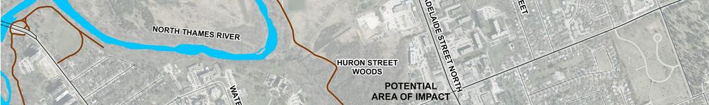
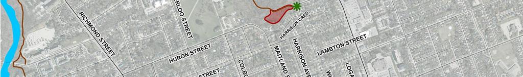
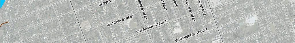
5 STUDY AREA -5


6 PROBLEM/OPPORTUNITY The Old North Servicing Strategy was completed in 2014 to develop a storm, sanitary and water servicing strategy for the Old North neighbourhood. Improvements to the existing Huron Creek storm outfall and natural channel were identified as a priority in the strategy. Problem/Opportunity: The Cheapside Street corridor, William Street and several other local streets in Old North require the combined sewers to be separated. The existing outfall structure and channel in Huron Street Woods does not have the capacity to accommodate additional flows from the new storm sewers. The outfall structure and channel need to be improved to accommodate increased flows and mitigate environmental impacts. 6


7 EXISTING CONDITIONS 2015 Channel and outfall cannot handle existing flows. Conditions include flooding and deterioration of multiuse pathway Open/aquatic swamp is a pond feature created by beaver activity Significant changes in the area between 2015 and The existing open pond/swamp feature has the potential to impact the Thames Valley Parkway during significant storm events. 7


 to occur in")


8 EXISTING CONDITIONS NATURAL ENVIRONMENT Ecological investigations in the potential impact area will be used to develop the recommended alternative. An Environmental Impact Study will be completed to document the investigation. Amphibian survey completed spring 2016 Surveys of plants, birds and fish will be completed in spring 2017 Potential for several Species at Risk (SAR) to occur in the area, which will be confirmed Huron Street Woods is a Significant Woodland that includes deciduous forest and open/aquatic swamp habitats. Photo credit: Walter Muma Native and exotic plants identified in 2016 survey. Flows from the outfall eventually reach the North Thames River. Photo credit: Ontario Wildflowers New England Aster Common Buckthorn 8

9 EXISTING CONDITIONS BEAVERS There is evidence of significant beaver activity in the vicinity of the outfall. Council has adopted a Beaver Protocol to implement the City s Humane Urban Wildlife Conflict Policy. The protocol balances competing priorities, including: Respect and protect beavers in their natural habitat Allow for enhancements to biodiversity and the creation of wetland environments Study Area Educate the public about the value of beaver created wetlands Protect critical infrastructure Protect people and property from flooding Maintain the use of the City s pathway and trail system. The Beaver Protocol will be applied to works required for this project. Photo Credit: Wikipedia


10 CONSTRAINTS/OPPORTUNITIES The following was considered when developing alternatives to address the problem/opportunity: Constraints Poor soil conditions for construction work Slope stability north of Harrison Crescent, some of Study Area which is on private property Existing critical trunk transmission watermain in the area Opportunities Provide storm sewers to areas where they currently don t exist Improve the environment by eliminating combined sewer flows Allow reconstruction and upgrading of local infrastructure Flooding and beaver activity near Thames Valley Parkway Existing outfall channel 10

11 ALTERNATIVE 1 - RECOMMENDED Description: Basic channel improvements from the existing headwall to the maintenance road Replace existing culvert with a larger culvert or bridge Maintain existing open aquatic/swamp feature but eliminate significant water ponding Pros Reduce flooding and standing water on the Thames Valley Parkway Minimal impact on existing watermain Minimal impact on natural environment Improved drainage Lowest construction cost Construction practical despite soil conditions Eliminate standing water at top of slope at rear of Harrison Crescent properties. Legend Multi-Use Path Existing Storm Maintenance Hole Existing Water Drain Chamber Structure Existing 1800 mm Storm Sewer Existing 600mm Watermain Low Flow Channel Water Grading Cons Potential for culvert to be impacted by beaver activity in the future 11


12 ALTERNATIVE 2 NOT RECOMMENDED Description Remove existing headwall Extend storm sewer approximately 35m Install new energy dissipating headwall Replace existing culvert with a larger culvert or bridge Maintain existing open aquatic/swamp feature but eliminate significant water ponding Pros Reduce flooding and standing water on the Thames Valley Parkway Impacts of increased flow are reduced (i.e. storm flow is contained in sewer longer) Minimal impact on natural environment Legend Multi-Use Path New Storm Maintenance Hole Existing Storm Maintenance Hole Existing Water Drain Chamber Structure New Storm Sewer Existing 1800mm Storm Sewer Existing 600mm Watermain Low Flow Channel Water Grading Cons Potential for culvert to be impacted by beaver activity Construction not cost effective due to existing soil conditions Impact on existing watermain due to poor soil conditions (i.e. high water table and approximately 2.5m thick organic layer) 12


13 ALTERNATIVE 3 NOT RECOMMENDED Description Remove existing headwall and culvert Extend storm sewer under maintenance road before outletting to the existing channel Install new energy dissipating headwall Maintain existing open aquatic/swamp feature but eliminate significant water ponding Pros Reduce flooding and standing water on the Thames Valley Parkway Reduce standing water Legend Multi-Use Path New Storm Maintenance Hole Existing Storm Maintenance Hole Existing Water Drain Chamber New Inlet Structure New Storm Sewer Existing 1800 mm Storm Sewer Existing 600mm Watermain Low Flow Channel Grading Cons Greater impact on natural environment Construction not cost effective due to existing soil conditions Greater impact on existing watermain due to poor soil conditions (i.e. high water table and approximately 2.5m thick organic layer) 13


14 ALTERNATIVE 4 NOT RECOMMENDED Description Remove existing headwall and culvert Extend storm sewer under maintenance road before outletting to the existing channel Install new energy dissipating headwall Install drain to direct overland flow to the storm sewer Grade and plant existing open aquatic/swamp feature using native species Pros Reduce flooding and standing water on the Thames Valley Parkway Legend Multi-Use Path New Storm Maintenance Hole Existing Storm Maintenance Hole Existing Water Drain Chamber Ditch Inlet Catch Basin Structure New Storm Sewer Existing Storm Sewer Existing 600mm Watermain Low Flow Channel Naturalized Area Grading Cons Greatest impact on natural environment Construction not cost effective due to existing soil conditions Impact on existing watermain due to poor soil conditions (i.e. high water table and approximately 2.5m thick organic layer) 14
15 RECOMMENDED ALTERNATIVE Alternative 1 is recommended: Meets objective to improve the storm sewer outfall and channel to accommodate increased flows Lowest impact on the natural environment and watermain Practical to construct despite soil conditions Lowest construction cost. Alternative 1 provides a balance between accommodating increased stormwater flows and minimizing disturbance in the Huron Street Significant Woodlot. Due to the limited impact and scope of work, this alternative is identified as a Schedule A+ activity under the Class EA. It is considered pre-approved and does not require an environmental assessment report to be prepared. The public will be advised prior to the implementation of the project. 15

16 NEXT STEPS THANK YOU FOR ATTENDING! Spring Summer Fall Winter Spring Summer Fall Your input is important to the outcome of this project. RESPOND TO INPUT PROVIDED Please complete and return a comment form by April 6, 2017 COMPLETE FIELD INVESTIGATIONS COMPLETE EA STUDY DETAILED DESIGN POTENTIAL CONSTRUCTION START Jason Johnson, P.Eng. Project Manager Dillon Consulting Limited 130 Dufferin Ave. Suite 1400 London, ON, N6A 4W7 Tel: Ext WilliamStreet@dillon.ca Kyle Chambers, P.Eng., Wastewater and Drainage Engineering City of London P.O. Box Dufferin Ave. London, ON, N6A 4L9 Tel: Ext kjchambe@london.ca Personal information collected and recorded at the Public Information Centre or submitted in writing on this subject is collected under the authority of the Municipal Act, 2011 and will be used by members of Council and City of London staff in their review of this matter. With the exception of personal information, all comments will become part of the public record. Questions about this collection should be referred to the City Clerk s office at
Vaughan Metropolitan Centre (VMC) Black Creek Renewal CLASS ENVIRONMENTAL ASSESSMENT
 Black Creek Renewal CLASS ENVIRONMENTAL ASSESSMENT") PUBLIC INFORMATION CENTRE Vaughan Metropolitan Centre (VMC) Black Creek Renewal Wednesday, May 10, 2017 6:00 p.m. to 8:00 p.m. Add photo Project Management, Environmental Assessment, Stormwater Management
PUBLIC INFORMATION CENTRE Vaughan Metropolitan Centre (VMC) Black Creek Renewal Wednesday, May 10, 2017 6:00 p.m. to 8:00 p.m. Add photo Project Management, Environmental Assessment, Stormwater Management
FANSHAWE PARK ROAD/RICHMOND STREET INTERSECTION IMPROVEMENTS. PUBLIC INFORMATION CENTRE 2 June 16, 2016
 FANSHAWE PARK ROAD/RICHMOND STREET INTERSECTION IMPROVEMENTS Municipal Class Environmental Assessment PUBLIC INFORMATION CENTRE 2 June 16, 2016 ACCESSIBILITY Under the Accessibility Standards 2015 for
Public Information Centre # 2 Coronation Park Drainage Improvements Town of Oakville Municipal Class Environmental Assessment
 November 26, 2014 Public Information Centre # 2 Coronation Park Drainage Improvements Town of Oakville Municipal Class Environmental Assessment Study Area & Drainage System Legend Coronation Project Park
Recreational Pathway Crossing of Richmond Street Municipal Class Environmental Assessment. Public Information Centre #2 April 22, 2015
 Recreational Pathway Crossing of Richmond Street Municipal Class Environmental Assessment Public Information Centre #2 April 22, 2015 1. Study Process PHASE 1 PHASE 2 PHASE 3 PHASE 1 : Problem/Opportunity
Blackfriars Bridge Municipal Class Environmental Assessment. Public Information Centre #1 November 19 th, 2014
 Blackfriars Bridge Municipal Class Environmental Assessment Public Information Centre #1 November 19 th, 2014 Why are you here tonight? To determine the future requirements of the river crossing at Blackfriars
Bostwick Road. Municipal Class Environmental Assessment. Public Information Centre #2 June 14, City of London
 Bostwick Road Municipal Class Environmental Assessment Public Information Centre #2 June 14, 2017 Welcome! Welcome to the 2 nd Public Information Centre for the. Representatives from the and the consulting
Bostwick Road. Municipal Class Environmental Assessment. October 13, City of London. Bostwick Road Municipal Class Environmental Assessment
 Bostwick Road Municipal Class Environmental Assessment October 13, 2016 Welcome! Welcome to the first Public Information Centre for the Bostwick Road Municipal Class Environmental Assessment. Representatives
Better Cycling. The City will update the cycling master plan (London ON Bikes) based on the approved BRT network.
 based on the approved BRT network.") Better Cycling Dedicated bike facilities will be constructed along BRT corridors where space is available. Nearby bike routes will also be upgraded to ensure a complete network is available for cyclists.
Better Cycling Dedicated bike facilities will be constructed along BRT corridors where space is available. Nearby bike routes will also be upgraded to ensure a complete network is available for cyclists.
Baby Point Wastewater Pumping Station Forcemain Class Environmental Assessment Study
 Baby Point Wastewater Pumping Station Forcemain Class Environmental Assessment Study Public Drop-in Event 1 Thursday, October 12, 2017 6:00 p.m. to 8:00 p.m. Humbercrest United Church Welcome Welcome to
Improvements Municipal Class Environmental Assessment. Public Information Centre #1 June 11, 2015
 Western Road & Sarnia Road/Philip Aziz Avenue Improvements Municipal Class Environmental Assessment Public Information Centre #1 June 11, 2015 1. Welcome We re hosting this Public Information Centre (PIC)
Public Information Centre. Welcome
 Transportation Improvements from the Beaver Creek Bridge to the Entrance of Santa s Village District of Muskoka Municipal Class Environmental Assessment Welcome Please sign in Take a comment sheet Staff
Mavis Road Class Environmental Assessment
 Mavis Road Class Environmental Assessment Public Information Centre #2 Wednesday November 9, 2016 6:00 to 8:00 p.m. Please sign in and complete a comment sheet Review the displays on your own or join in
Biodiversity Conservation
 Biodiversity Conservation and Site Plan Review Biodiversity conservation principles Threats to biodiversity Location of development Reviewing site plans Lunch Reviewing site plans (continued) LEED and
City of Kitchener Integrated Stormwater Management Master Plan (ISWM-MP) Public Open House No. 2 April 28, 2016
 Public Open House No. 2 April 28, 2016") City of Kitchener Integrated Stormwater Management Master Plan (ISWM-MP) Public Open House No. 2 April 28, 2016 Open House Format 20-30 min presentation Facilitated questions and answer session following
City of Kitchener Integrated Stormwater Management Master Plan (ISWM-MP) Public Open House No. 2 April 28, 2016 Open House Format 20-30 min presentation Facilitated questions and answer session following
Municipal Class EA Study Public Information Centre No. 1 December 13, :00 pm 7:00 pm. Please sign in so we can keep you updated on this study
 Reconstruction of Regional Road 45 (Creek Road) Between Regional Road 27 (River Road) and Regional Road 63 (Canborough Road) in the Township of Wainfleet Municipal Class EA Study Public Information Centre
Cherry Beach Shoreline Protection Infrastructure Conceptual Design and Class EA
 Welcome Cherry Beach Shoreline Protection Infrastructure Conceptual Design and Class EA May 3, 2012 Study Area Cherry Beach neighbourhood is located in lower Stoney Creek on Lake Ontario, east of Millen
Welcome. Date: Thursday March 2, 2017 Time: 6:30 p.m. 9:00 p.m. Location: Woodview School Gym, 69 Flatt Road, Burlington Presentation Time: 7:00 p.m.
 Welcome Public Information Centre No.2 City of Burlington, City of Hamilton, Region of Halton Waterdown Road Widening Detailed Design Craven Avenue to Mountain Brow Road Date: Thursday March 2, 2017 Time:
City of Cornwall Municipal Class Environmental Assessment. Proposed Improvement and Extension of Lemay Street
 Welcome City of Cornwall Municipal Class Environmental Assessment Proposed Improvement and Extension of Lemay Street Redevelopment and Design of the Municipal Works Yard Public Information Centre #1 Thursday,
West London Dyke, April 1947 Flood. Forks of the Thames, July 2000 Flood. Source: UTRCA
 This Public Information Centre is the 1 st of 2. Its purpose is to inform the public and to receive input with regards to the West London Dyke Master Repair Plan. The following panels describe the history,
Highlands Region Stormwater Management Program Guidance
 DRAFT Highlands Region Stormwater Management Program Guidance Release Date: January 2016 Abstract This guidance document provides an overview of the Highlands Stormwater Management Program. It is intended
Working Group Meeting
 April 4,, 2017 Parks Operations Bldg Working Group Meeting Arts Districts Overview Stormwater/RPA/Stream Considerations First Principles Agenda 7:00pm 7:05pm 7:10pm 7:40pm 8:30pm 9:40pm 9:45pm Welcome
Public Information Centre #1
 and Highway 401 Interchange Improvements WELCOME Public Information Centre #1 Veterans Memorial Parkway Extension and Highway 401 Interchange Improvements Study May 23, 2012 4 p.m. to 7 p.m. Brief Overview
APPENDIX 1: SCOPED ENVIRONMENTAL IMPACT STATEMENT (EIS) FORM
 FORM") APPENDIX 1: SCOPED ENVIRONMENTAL IMPACT STATEMENT (EIS) FORM This form is intended for use by applicants (primarily private landowners) who need to conduct a Scoped EIS in support of minor development
APPENDIX 1: SCOPED ENVIRONMENTAL IMPACT STATEMENT (EIS) FORM This form is intended for use by applicants (primarily private landowners) who need to conduct a Scoped EIS in support of minor development
City of Greater Sudbury Subwatershed Study Program. Public Open House Tom Davis Square, C-13 A and B March 9, 2016
 City of Greater Sudbury Subwatershed Study Program Public Open House Tom Davis Square, C-13 A and B March 9, 2016 Welcome to the City of Greater Sudbury Subwatershed Study Program Public Open House Tom
WASHINGTON COUNTY OREGON
 WASHINGTON COUNTY OREGON LONG RANGE PLANNING DIVISION North Bethany Subarea Stream Corridors: Existing Regulations In Oregon, there is a distinct difference between the land use rules that apply in rural
WELCOME. Land North of STEVENAGE. We would like to thank you for attending our public exhibition today.
 WELCOME We would like to thank you for attending our public exhibition today. The purpose of this event is to share our proposals and hear your thoughts on our ideas. Members of the project team are on
GLEN ROAD PEDESTRIAN BRIDGE ENVIRONMENTAL ASSESSMENT STUDY PUBLIC INFORMATION CENTRE #2 OCTOBER 24, 2017
 GLEN ROAD PEDESTRIAN BRIDGE ENVIRONMENTAL ASSESSMENT STUDY PUBLIC INFORMATION CENTRE #2 OCTOBER 24, 2017 Glen Road Pedestrian Bridge Class Environmental Assessment 1 WELCOME! Welcome to the second Public
Master Environmental Servicing Plan & Secondary Plan
 East Side Lands Stage 2 1 Master Environmental Servicing Plan & Secondary Plan Public Information Centre #1 June 16, 2016 Welcome! Today s Agenda Please sign in at the front desk. 5:30 pm 6:30 pm: Open
Public Information Centre
 Public Information Centre Sunnidale Road Highway 400 Transmission i Watermain Crossing January 31, 2012 Sir Robert Barrie Room, 2 nd Floor, City Hall 4:00 pm to 7:00 pm As part of the Environmental Assessment
Second Line West Pedestrian/Cyclist Crossing of Highway 401 Class EA. Second Line West Pedestrian/Cyclist Crossing of Highway 401 Class EA
 1 1 Purpose of Public Information Centre #2 To provide interested and/or potentially affected stakeholders with an opportunity to participate in the planning and decision-making process for this Municipal
Chapter 5: Natural Resources and Environment
 NATURAL RESOURCES AND ENVIRONMENT 5-1 5 Chapter 5: Natural Resources and Environment BACKGROUND AND INTENT Urban expansion represents the greatest risk for the future degradation of existing natural areas,
Edgeley Pond + Park Public Meeting
 Edgeley Pond + Park Public Meeting February 21, 2017 Purpose of the meeting This Public Meeting is an opportunity for you to review the project background, process and provide input. City of Vaughan staff
Chapter 3 Site Planning and Low Impact Development
 CHAPTER 3 Site Planning and Low Impact Development Chapter 3 Site Planning and Low Impact Development 3.0 Introduction The City of Charleston requires that major residential, large commercial (>1 acre),
Station Expansion Project
 Streetsville Reservoir and Pumping Station Expansion Project Public Information Centre Paul Dagenais, P.Eng. AECOM September 23, 2010 Erin Meadows Community Centre Purpose of Tonight s Meeting Update residents
Checklists. Project Name: Location: File Number: Date of Submittal: Reviewer: Date: Applicant: Contact Name: Phone Number:
 Applicant: Contact Name: Phone Number: Email: Project Name: Location: File Number: Date of Submittal: Reviewer: Date: Concept Plan Requirements: I. General Project Information 1. Address or parcel number
USF System Campus Master Plan Updates Goals, Objectives and Policies
 2015-2025 USF System Campus Master Plan Updates Goals, Objectives and Policies Tampa Goals, Objectives, and Policies Table of Contents Executive Summary 2015 2025 USF Campus Master Plan Update Introduction
Commissioners Road West Realignment Environmental Assessment
 City of London Commissioners Road West Realignment Environmental Assessment Public Information Centre No. 1 March 30, 2017 Welcome to the Public Information Centre This first Public Information Centre
STREAM BUFFERS
 88-415 STREAM BUFFERS 88-415-01 PURPOSE In the Kansas City region and throughout the nation, vegetated stream buffers have been clearly shown to protect stream stability and related infrastructure, improve
Ashbridges Bay Erosion and Sediment Control Project
 Ashbridges Bay Erosion and Sediment Control Project Project Brief Overview Toronto and Region Conservation Authority, in partnership with the City of Toronto, intends to carry out remedial erosion control
South Bismarck Watershed Model Update and Stormwater Improvement Project
 Preliminary Engineering Report Bismarck Tribune South Bismarck Watershed Model Update and Stormwater Improvement Project City of Bismarck, ND January 2017 14.105.0046 1.0 Executive Summary The focus of
Welcome. Tannery and Waterworks Parks Shoreline Improvements Environmental Assessment. Public Information Centre #1 November 27, pm to 8 pm
 Welcome Tannery and Waterworks Parks Shoreline Improvements, Environmental Assessment Tannery and Waterworks Parks Shoreline Improvements Environmental Assessment #1 6 pm to 8 pm Why We Are Here Tannery
Stormwater Regulations & Considerations Morse Study Area. Pam Fortun, P.E. CFM Senior Stormwater Treatment Engineer Engineering Services Division
 Stormwater Regulations & Considerations Morse Study Area Pam Fortun, P.E. CFM Senior Stormwater Treatment Engineer Engineering Services Division Stormwater Regulations Development Considerations Floodplain
OVERMOUNTAIN VICTORY TRAIL BURKE CALDELL CORRIDOR FEASIBLITY STUDY REQUEST FOR QUALIFICATIONS CALDWELL COUNTY PATHWAYS
 OVERMOUNTAIN VICTORY TRAIL BURKE CALDELL CORRIDOR FEASIBLITY STUDY REQUEST FOR QUALIFICATIONS CALDWELL COUNTY PATHWAYS Caldwell County Pathways along with our co-partners City of Lenoir, Town of Gamewell,
Rapid Transit Implementation Working Group September 14, 2017
 Rapid Transit Implementation Working Group September 14, 2017 BACKGROUND Council approved the Rapid Transit Master Plan and Updated Business Case on July 25, 2017. Approval of the RTMP confirmed the BRT
Western Road/Wharncliffe Road North Widening from Platts Lane to Oxford Street. Municipal Class Environmental Assessment Public Information Centre #1
 Western Road/Wharncliffe Road North Widening from Platts Lane to Oxford Street Municipal Class Environmental Assessment Public Information Centre #1 June 11, 2014 Welcome Welcome to the first Public Information
MASTER DEVELOPMENT DRAINAGE PLAN FOR MONUMENT HEIGHTS
 MASTER DEVELOPMENT DRAINAGE PLAN FOR MONUMENT HEIGHTS DRAINAGE REPORT STATEMENT ENGINEER'S STATEMENT: The attached drainage plan and report were prepared under my direction and supervision and are correct
The purpose of tonight s PIC is to:
 The purpose of tonight s PIC is to: Provide an overview of the work completed to date and a summary of the Class EA process being followed; Provide a summary of public input received so far, including
Design Specifications & Requirements Manual
 11 PARKS & OPEN SPACES 11.1 DEFINITIONS... 1 11.1.1 Neighbourhood Parks... 1 11.1.2 District Parks... 1 11.1.3. Sport Parks... 1 11.1.4 Urban Parks... 1 11.1.5 Civic Spaces... 1 11.1.6 Open Space System...
Southwest Fleetwood Enclave
 Southwest Fleetwood Enclave Development Concept Plan Southwest Fleetwood Enclave 1 st Land Owners Meeting April 30 th, 2012 Presentation Overview Why the Plan? ; Overview & Purpose of Study; Constraints
Design Specifications & Requirements Manual
 11 PARKS & OPEN SPACES 11.1 DEFINITIONS... 1 11.1.1 Neighbourhood Parks... 1 11.1.2 District Parks... 1 11.1.3. Sport Parks... 1 11.1.4 Urban Parks... 1 11.1.5 Civic Spaces... 1 11.1.6 Open Space System...
HS2 Environment. Protecting the environment
 HS2 Environment Protecting the environment Approach to mitigation EIA Regulations require an ES to include a description of the measures envisaged in order to avoid, reduce and, if possible, remedy significant
Executive Committee Meeting Addendum. #7/15 July 3, :30 A.M. HEAD OFFICE, 101 EXCHANGE AVENUE, VAUGHAN Members:
 Executive Committee Meeting Addendum #7/15 July 3, 2015 9:30 A.M. HEAD OFFICE, 101 EXCHANGE AVENUE, VAUGHAN Members: Maria Augimeri Michael Di Biase David Barrow Ronald Chopowick Vincent Crisanti Glenn
SUMMARY ASSESSMENT MATRIX
 ASSESSMENT MATRIX Legend: Least Preferred Most Preferred Natural Environment Terrestrial Ecosystems Avoids regulated SAR habitat. Avoids regulated SAR habitat. Avoids creating a new crossing of the features.
Thorncrest Village Neighbourhood Improvements Public Drop-In Event
 Thorncrest Village Neighbourhood Improvements 2018-2020 Public Drop-In Event Thorncrest Village Clubhouse February 27 th 2018 Drop-In From 3:30 5:00 or 7:00 9:00 0 1 Purpose of the Drop-In Event The purpose
WELCOME! 8 8:30 6: TH STREET IMPROVEMENTS. Open House. Presentation & Q&A
 WELCOME! 168 TH STREET IMPROVEMENTS 6:30 Open House 7 8 Presentation & Q&A 8 8:30 Open House WELCOME Todd Pfitzer City of Omaha Engineer Bob Stubbe City of Omaha Public Works Director Jon Meyer Project
Meeting Agenda. City of Guelph. River Systems Advisory Committee. Agenda Items. Item 1, 2 and 3. Item 4 Ward to Downtown Pedestrian Bridge
 Meeting Agenda City of Guelph River Systems Advisory Committee September 19, 2018 City Hall, Meeting Room B From 4:00 to 6:00 p.m. Meeting Chair: Mariette Pushkar Agenda Items Welcome to all Item 1, 2
THREE-STEP DESIGN PROCESS FOR OPEN SPACE SUBDIVISIONS
 00216106.DOC NMA/RRK 1/30/14 THREE-STEP DESIGN PROCESS FOR OPEN SPACE SUBDIVISIONS Open space subdivisions, sometimes called cluster developments, maintain a significant portion of a development site in
The Planning Partnership Baird + Associates TCI Management Consultants Ltd. Plan B Natural Heritage Wills Consulting Engineers Poulos & Chung Limited
 Little Lake Master Plan The Planning Partnership Baird + Associates TCI Management Consultants Ltd. Plan B Natural Heritage Wills Consulting Engineers Poulos & Chung Limited May 26, 2009 Purpose of Study
GEOMETRIC IMPROVEMENTS AND WATERMAIN LOOPING MUNICIPAL CLASS ENVIRONMENTAL ASSESSMENT
 GEOMETRIC IMPROVEMENTS AND WATERMAIN LOOPING MUNICIPAL CLASS ENVIRONMENTAL ASSESSMENT Veterans Way (previously Powerline Road) and Klondike Park Road Wasaga Beach Welcome Please sign in Take a comment
STORM SEWER OUTFALLS AND CONNECTING OUTFALL CHANNELS. General Submission Requirements
 COMPLETE APPLICATION CHECKLIST Jan 2016 STORM SEWER OUTFALLS AND CONNECTING OUTFALL CHANNELS The following checklist has been compiled to assist the applicant in preparing their application for approval
CHECKLIST FOR PHASE II DRAINAGE REPORT
 I. COVER SHEET CHECKLIST FOR PHASE II DRAINAGE REPORT A. Name of Project B. Address C. Owner D. Developer E. Engineer F. Submittal date and revision dates as applicable II. GENERAL LOCATION AND DESCRIPTION
elcome Public Information Centre No. 3 May 12, 2009 Burnhamthorpe Road East From Arista Way to Dixie Road Class Environmental Assessment (EA) Study
 Study") W elcome to Public Information Centre No. 3 for the Burnhamthorpe Road East From Arista Way to Dixie Road Class Environmental Assessment (EA) Study You can participate in this study by: Signing the attendance
W elcome to Public Information Centre No. 3 for the Burnhamthorpe Road East From Arista Way to Dixie Road Class Environmental Assessment (EA) Study You can participate in this study by: Signing the attendance
Commissioners Road West Realignment Environmental Assessment
 City of London Commissioners Road West Realignment Environmental Assessment Public Information Centre No. 2 November 29, 2017 Welcome to the Public Information Centre This 2 nd Public Information Centre
RFP DRAINAGE OUTFALL DESIGN AND PERMITTING. Mandatory Meeting for Proposers August 15, 2015
 RFP 2018-02 DRAINAGE OUTFALL DESIGN AND PERMITTING Mandatory Meeting for Proposers August 15, 2015 IMPORTANT DATES August 15 th, 2:00pm August 17 th, 5:00pm August 22 nd, 5:00pm September 5 th, 2:00pm
Tigard. City TIGARD STORMWATER. ofn MASTER PLAN. Respect and Care Do the Right Thing Get it Done. Tualatin River Watershed Council
 City ofn Tigard Respect and Care Do the Right Thing Get it Done TIGARD STORMWATER MASTER PLAN Tualatin River Watershed Council January 4, 2017 Tigard Stormwater Master Plan Why It s Needed Long Overdue:
Level 1 Downstream Analysis
 Level 1 Downstream Analysis Newcastle Way Apartments Newcastle, Washington King County April 14, 2014 Revised July 10, 2014 Prepared by: Dean A. Furr, P.E. Reviewed by: Donald Scarberry, P.E. Coffman Engineering,
Portage Parkway Environmental Assessment Public Information Centre No. 1
 City of Vaughan Portage Parkway Environmental Assessment Public Information Centre No. 1 November 25, 2015 Welcome to the Public Information Centre This first Public Information Centre (PIC) introduces
TERRESTRIAL NATURAL HERITAGE SYSTEM STRATEGY APPENDIX F: MODEL POLICIES FOR THE IMPLEMENTATION OF THE TARGET TERRESTRIAL NATURAL HERITAGE SYSTEM
 TERRESTRIAL NATURAL HERITAGE SYSTEM STRATEGY APPENDIX F: MODEL POLICIES FOR THE IMPLEMENTATION OF THE TARGET TERRESTRIAL NATURAL HERITAGE SYSTEM C H A P T E R 1 M O D E L P O L I C I E S F O R I M P L
The Gore Road Queen Street East to Castlemore Road
 Municipal Class Environmental Assessment The Gore Road Queen Street East to Castlemore Road Public Open House # 1 Date: Thursday May 29, 2014 Time: 5:30pm to 8:30pm Location: Gore Meadows Community Centre
Public Information Centre No. 1 King-Vaughan Road Bridge Replacement Municipal Class Environmental Assessment City of Vaughan
 Public Information Centre No. 1 King-Vaughan Road Bridge Replacement Municipal Class Environmental Assessment City of Vaughan Date: April 7, 2016 Location: Al Palladini Community Centre, Meeting Room #1
When planning stormwater management facilities, the following principles shall be applied where possible.
 2.0 Principles When planning stormwater management facilities, the following principles shall be applied where possible. 2.0.1 Drainage is a regional phenomenon that does not respect the boundaries between
Heritage Road Improvements from Steeles Avenue to Rivermont Road
 The Corporation of the City of Brampton Heritage Road Improvements from Steeles Avenue to Rivermont Road Class Environmental Assessment Study (Schedule C) September 19, 2013 The Corporation of the City
Public Consultation. Land at Monks Farm, North Grove. Welcome
 Welcome Welcome to our public exhibition for development on Land at Monks Farm, orth Grove. Gallagher Estates and Gleeson Strategic Land are preparing an outline planning application for new homes, open
St. Clair Avenue West Area Transportation Master Plan
 1 (Between Keele Street and Old Weston Road) Public Information Centre 1 December 2, 2015 2 Welcome Welcome to the first Public Information Centre for the St. Clair Avenue West Area. The panels will present
AMENDMENT NO. 30 TO THE OFFICIAL PLAN OF THE TOWN OF MILTON
 AMENDMENT NO. 30 TO THE OFFICIAL PLAN OF THE TOWN OF MILTON Subject: Boyne Survey Secondary Plan and Related Official Plan Amendments The following text and schedules constitute Amendment No. 30 to the
MDOT Stormwater BMPs: The Challenge of Design. Janeen McDermott, PE Dan DeVaun, PE
 MDOT Stormwater BMPs: The Challenge of Design Janeen McDermott, PE Dan DeVaun, PE June 25, 2018 Outline Water Quality Treatment Water Quality Treatment Volume Guidelines Example Project BMP Design Challenges
WELCOME TO OPEN HOUSE TWO November 28, 2018
 Langstaff Road Weston Road to Highway 7 Class Environmental Assessment Study WELCOME TO OPEN HOUSE TWO November 28, 2018 Please sign in and join our mailing list Study Overview York Region is conducting
Caledon Villas Corp. c/o Mr. John Spina 55 Blue Willow Drive Woodbridge, ON L4L 9E8 May 14, Floodplain Characteristics, Old Church Road
 Caledon Villas Corp. c/o Mr. John Spina 55 Blue Willow Drive Woodbridge, ON L4L 9E8 May 14, 2013 Re: Floodplain Characteristics, Old Church Road This letter serves to confirm that I, Linda Sober, have
DEVELOPMENT PERMIT SENSITIVE ECOSYSTEMS
 DEVELOPMENT PERMIT SENSITIVE ECOSYSTEMS What is the Sensitive Ecosystem Development Permit Area (SEDPA)? Surrey s SEDPA is made up of two distinct classifications of the natural environment: Streamside
Phase I Ecological Network Report Terms of Reference
 Phase I Ecological Network Report Terms of Reference INTRODUCTION In 2007, the City of Edmonton created a new Natural Area Systems Policy (C-531) and a strategic plan, Natural Connections. Together, these
Chapter 4 - Preparation of Stormwater Site Plans
 Chapter 4 - Preparation of Stormwater Site Plans The Stormwater Site Plan is the comprehensive report containing all of the technical information and analysis necessary for the City to evaluate a proposed
Draft Rhode Island Stormwater Design and Installation Standards Manual
 Draft Rhode Island Stormwater Design and Installation Standards Manual Summary The May 2009 Public Review Draft version of the RI Stormwater Design and Installation Standards Manual consists of approximately
Community Engagement Committee Meeting #1 December 10, :30pm-8:30pm
 Community Engagement Committee Meeting #1 December 10, 2014 6:30pm-8:30pm Welcome and Introductions Dana Murdoch Minneapolis Park and Recreation Board Project Manager Ryan French Walker Art Center Director
Project Output Indicators for Federal Gas Tax Investments
 Municipalities are required to report results achieved through the investment of federal Gas Tax funds under the Municipal Funding Agreement. AMO uses the indicators listed below to capture the outputs
Public Meeting #3 May 9, 2009 MVVA Team
 Public Meeting #3 May 9, 2009 MVVA Team Welcome to the third Public Meeting for the Lower Don Lands Municipal Class Environmental Assessment (EA) Infrastructure Master Plan and Keating Channel Precinct
Purpose of Open House #3
 Public Meeting #3 May 9, 2009 MVVA Team Purpose of Open House #3 The main purpose of this Open House is to present and seek input on the: Evaluation of transportation and infrastructure design alternatives
HUNTSVILLE PHYSICAL SERVICES DEPARTMENT
 HUNTSVILLE PHYSICAL SERVICES DEPARTMENT URBAN DEVELOPMENT SITE PLAN CONTROL DRAWING DESIGN GUIDE April, 2000 (Revised June, 2003) TABLE OF CONTENTS Part A. General Information Page 1 Part B. Site Servicing
FY STATEWIDE TRANSPORTATION IMPROVEMENT PROGRAM New Jersey Department of Transportation Projects
 ROUTE/ Project ID No. TIP No. Burlington County Computerized Signal Control, IV D9911 D9911 This ITS project will be a traffic responsive signal system, consisting of 24 intersections--9 on CR 607, 4 on
HAZARD MITIGATION GOALS AND OBJECTIVES
 SEWRPC Community Assistance Planning Report No. 282, 2nd Edition CITY OF MILWAUKEE ALL HAZARDS MITIGATION PLAN UPDATE Chapter IV HAZARD MITIGATION GOALS AND OBJECTIVES [NOTE: Throughout this plan update
Dundas Place Flexible Street Public Information Centre
 WELCOME TO THE DUNDAS PLACE DESIGN REVEAL Dundas Place Flexible Street Public Information Centre November 8, 2017 This project is funded by the City of London with support from the Government of Canada
DEPARTMENT OF PUBLIC WORKS & UTILITIES
 CITY OF PORT ANGELES DEPARTMENT OF PUBLIC WORKS & UTILITIES URBAN SERVICES STANDARDS AND GUIDELINES January 2017 Craig Fulton, P.E., Director TABLE OF CONTENTS "URBAN SERVICES STANDARDS AND GUIDELINES"
TRCA Field Staking Protocol December 2016
 Page 1 of 6 TRCA Field Staking Protocol December 2016 This Protocol describes TRCA staff s current practice for field staking the physical top of bank, the physical toe of slope, and the limit of existing
TORONTO TRANSIT COMMISSION AND THE REGIONAL MUNICIPALITY OF YORK
 TORONTO TRANSIT COMMISSION AND THE REGIONAL MUNICIPALITY OF YORK NOTICE OF PREPARATION OF AN ADDENDUM REPORT TO THE HIGHWAY 7 CORRIDOR AND VAUGHAN NORTH-SOUTH LINK ENVIRONMENTAL ASSESSMENT & RESPONSE TO
APPENDIX F: EXTERNAL APPROVALS
 1.0 RESPONSIBILITIES When the City is constructing the Park or Open Space Development lands (OPTION I), after the subdivision construction process is completed by the Developer, Open Space Development
E16: MAINTENANCE OF LANDSCAPED AREAS
 HIGH SPEED TWO INFORMATION PAPER E16: MAINTENANCE OF LANDSCAPED AREAS This paper outlines the proposed approach to the maintenance of landscaped areas created for HS2 Phase One. It will be of particular
STILL CREEK CD-1 GUIDELINES (BY-LAW NO. 6654) Adopted by City Council April 24, 1990
 Adopted by City Council April 24, 1990") $2 City of Vancouver Land Use and Development Policies and Guidelines Community Services, 453 W. 12th Ave Vancouver, BC V5Y 1V4 F 604.873.7344 fax 873.7060 planning@city.vancouver.bc.ca STILL CREEK CD-1
$2 City of Vancouver Land Use and Development Policies and Guidelines Community Services, 453 W. 12th Ave Vancouver, BC V5Y 1V4 F 604.873.7344 fax 873.7060 planning@city.vancouver.bc.ca STILL CREEK CD-1
MAYFIELD WEST SECONDARY PLAN PHASE 2
 MAYFIELD WEST SECONDARY PLAN PHASE 2 Council Information Workshop February 16, 2010 Draft Preferred Land Use Plan TOWN OF CALEDON PLANNING & DEVELOPMENT DEPARTMENT Workshop Agenda TOWN OF CALEDON 1. Welcome
Linden Homes Proposals for land off Ringwood Road, Verwood
 Welcome Welcome to Linden Homes first public exhibition displaying proposals for new homes on land off Ringwood Road in Verwood. Award-winning house builder Linden Homes, part of the Galliford Try Group,
Arkansas River Corridor
 Planning for Access Welcome to the Access Project. This project is a recreational planning effort in response to an interest by regional communities along the Arkansas River corridor. The project plan
Flooding Hearing: Long and Short Term Strategies
 Services of the San Francisco Public Utilities Commission Flooding Hearing: Long and Short Term Strategies Presentation to San Francisco Board of Supervisors Public Safety and Neighborhood Services Subcommittee